Article

Fusion of Airborne, SLAM-Based, and iPhone LiDAR for Accurate Forest Road Mapping in Harvesting Areas

by
Evangelia Siafali
1,
Vasilis Polychronos
2 and
Petros A. Tsioras
3,*
1
Laboratory of Mechanical Science and Topography, School of Forestry and Natural Environment, Aristotle University of Thessaloniki, 541 24 Thessaloniki, Greece
2
Geosense, Geoinformatics Company, 570 13 Oreokastro, Greece
3
Laboratory of Forest Utilization, School of Forestry and Natural Environment, Aristotle University of Thessaloniki, 541 24 Thessaloniki, Greece
*
Author to whom correspondence should be addressed.
Land 2025, 14(8), 1553; https://doi.org/10.3390/land14081553
Submission received: 15 June 2025 / Revised: 15 July 2025 / Accepted: 26 July 2025 / Published: 28 July 2025

Abstract

This study examined the integraftion of airborne Light Detection and Ranging (LiDAR), Simultaneous Localization and Mapping (SLAM)-based handheld LiDAR, and iPhone LiDAR to inspect forest road networks following forest operations. The goal is to overcome the challenges posed by dense canopy cover and ensure accurate and efficient data collection and mapping. Airborne data were collected using the DJI Matrice 300 RTK UAV equipped with a Zenmuse L2 LiDAR sensor, which achieved a high point density of 285 points/m2 at an altitude of 80 m. Ground-level data were collected using the BLK2GO handheld laser scanner (HPLS) with SLAM methods (LiDAR SLAM, Visual SLAM, Inertial Measurement Unit) and the iPhone 13 Pro Max LiDAR. Data processing included generating DEMs, DSMs, and True Digital Orthophotos (TDOMs) via DJI Terra, LiDAR360 V8, and Cyclone REGISTER 360 PLUS, with additional processing and merging using CloudCompare V2 and ArcGIS Pro 3.4.0. The pairwise comparison analysis between ALS data and each alternative method revealed notable differences in elevation, highlighting discrepancies between methods. ALS + iPhone demonstrated the smallest deviation from ALS (MAE = 0.011, RMSE = 0.011, RE = 0.003%) and HPLS the larger deviation from ALS (MAE = 0.507, RMSE = 0.542, RE = 0.123%). The findings highlight the potential of fusing point clouds from diverse platforms to enhance forest road mapping accuracy. However, the selection of technology should consider trade-offs among accuracy, cost, and operational constraints. Mobile LiDAR solutions, particularly the iPhone, offer promising low-cost alternatives for certain applications. Future research should explore real-time fusion workflows and strategies to improve the cost-effectiveness and scalability of multisensor approaches for forest road monitoring.

1. Introduction

Forest roads are crucial for accessing, managing, and exploiting forested areas. They enable the cost-effective and efficient movement of timber from logging sites to processing and concentration locations, enhancing the forest-industry logistics and transportation infrastructure, and they also contribute to the development of mountainous regions. These roads are crucial for economic access to forest resources and minimizing environmental impacts [1,2,3,4,5,6,7,8,9,10,11]. They are often constructed as logging roads to facilitate the transit of equipment and wood during harvesting and are planned, constructed, and designed based on terrain morphology, forest use, and ecosystem habitat and stand characteristics. In addition, they are connected to other management activities such as stand establishment, maintenance, monitoring, or surveying [3,12,13,14] as well as high-quality recreational activities in the form of hiking trails [15].
Forest road network design—its position and alignment with topography and soils—is the most significant variable in long-term sustainability [16,17,18]. Maintenance needs may vary based on road regulations, construction materials, traffic volume, and extreme weather events due to changes in frequency and patterns induced by climate change [19]. Thus, regular monitoring is necessary to assess the wear and repair condition of forest roads before they develop into more difficult-to-solve problems [20,21].
Forest road monitoring is predominantly conducted by manual inspection, which is labor-intensive and costly [19,21,22,23]. Financial obstacles significantly impact road maintenance initiatives, making it difficult to finance essential repairs and improvements. Furthermore, the reduction in timber harvests and evolving environmental design standards have increased costs for drainage systems and forest constructions [21,24]. In recent years, it has been reported that government organizations also have fewer professionals available to evaluate and supervise maintenance tasks [3,24]. Complete and regularly updated information on the road surface is crucial for forest management [25] and harvesting operations [26], especially considering that, in some countries, transportation expenses in forestry account for 45% of operating costs [22]. From a conservation standpoint, the primary environmental concern lies in soil erosion, a complex and irreversible phenomenon involving multiple components [27,28]. Forest operations, especially skidding, compact forest soil and alter its physical and chemical qualities [29,30,31,32,33,34,35,36]. The sustainability of a certain wood extraction technology is determined not only by its cost-effectiveness but also by its capacity to minimize disruption to forest soil and natural ecosystems [37].
Accurate spatial information on forest road network elements is important. Field surveys, which are labor-intensive and expensive, and accurate data collection can be challenging to collect. Traditional remote sensing techniques often become inefficient due to the density of forest canopies [38]. To effectively manage forest road networks, a combination of datasets from various sources, like field observations, LiDAR data, and remote sensing information, needs to be integrated with GIS to optimize reporting, analysis, and planning [39,40].
Techniques such as Terrestrial Laser Scanning (TLS), UAV photogrammetry, and LiDAR have enabled detailed topographic mapping [15,37,41]. Unmanned Aerial Vehicles (UAVs) have been proven to be highly effective equipment for acquiring reliable data in identifying road deformations in an accurate and cost-efficient manner [2,42,43,44]. UAV aerial photography has advanced rapidly over the last decade and, due to its ability to take off and land vertically, lack of sensitivity to different environments, high mobility and stability, and ease of operation, can produce high-quality, reliable, and accurate results [45,46]. Accurate spatial information on forest roads is important for forest management [15,47], harvesting operations [48], and infrastructure monitoring [25].
Recent advancements have enhanced remote sensing in forest inventory, notably with mobile LiDAR systems used under dense canopies. These face GNSS signal limitations, which Simultaneous Localization and Mapping (SLAM)-based georeferencing helps overcome [49]. Studies show that LiDAR sensors can detect minor road surface deformations [50] and that smartphone-integrated LiDAR, such as in the iPhone 13 Pro, offers fast, cost-effective mapping without GNSS coverage [25,51,52,53]. While these tools are promising, their precision compared to professional equipment remains under evaluation [25,54,55].
Graph-SLAM and SLAM-based methodologies are progressively used for road surveillance and forest mapping [40,47,56,57,58,59,60,61]. UAV-based photogrammetry demonstrates potential for detecting road surface deterioration with high spatial precision [7,62,63,64]. Despite technological advancements, affordable LiDAR and mobile scanning technologies frequently fail to reach the precision of conventional methods due to environmental factors such as dense canopy cover, variable terrain, and lighting conditions [15,65,66,67,68,69]. Integrating point clouds from UAVs, SLAM, and smartphone LiDAR enhances Digital Elevation Model (DEM) accuracy and road visualization, facilitating informed forestry decisions. Nonetheless, the co-registration of such varied data sources remains undervalued and challenging [59,70].
Nevertheless, technical standards for forest road maintenance have not yet been adapted to utilize these emerging technologies, limiting their systematic integration into practice. Mapping accuracy today depends on factors like camera quality, GPS signal, image overlap, ground control, and processing software, among others. Traditional criteria based on map or film scale no longer apply to modern geospatial methods [71]. In this context, the modern mapping and monitoring technologies may facilitate bridging the existing gaps between forestry and new technological advancements to the benefit of forest management.
The aim of this study is to merge point clouds derived from three distinct technologies (LiDAR UAV, SLAM-based handheld mapping, and iPhone LiDAR) and combinations of equipment that include consumer-grade devices such as the iPhone 13 Pro Max for its LiDAR sensor. The merged point clouds were used to produce DEMs that were assessed for their accuracy using ALS data as the reference dataset and data derived from the GNSS RTK method. Additionally, the sensor performance was evaluated under varying terrain conditions. The primary goal is to enhance forest management by developing a cost-effective monitoring framework that optimizes optimal sensor and equipment selection for specific physiogeographical conditions.

2. Materials and Methods

2.1. Study Area Description

The study area (Figure 1) is located on Olympus Mountain and covers an area of 7.78 ha. Olympus became the first National Park in 1938 and has been designated as a Biosphere Reserve since 1981 by the UNESCO Man and the Biosphere Program. Nowadays, the study area is managed by the Greek Forestry Service.
We investigated a forest road (4,447,302.32 N 362,659.96 E to 4,447,559.52 N 363,013.54 E), which spans a total length of 608 m, with an elevation ranging from 381 m to 436 m (Table 1). The road passes through timber harvesting areas. The research was conducted in July 2024. The weather during the data collecting day was characterized by temperatures ranging from 20 to 30 °C, and the sky was clear.
The focus initially was on the condition of the road surface. Surface flatness is one of the most important characteristics; however, it cannot be assessed in isolation from other factors such as surface wear, structural condition, and seasonal damage. These factors contribute to road surface unevenness, as potholes and tire tracks do. The input data consisted of Digital Elevation Models (DEMs) with a spatial resolution of 0.2 m.

2.2. Aerial Laser Scanning Acquisition Data and Processing

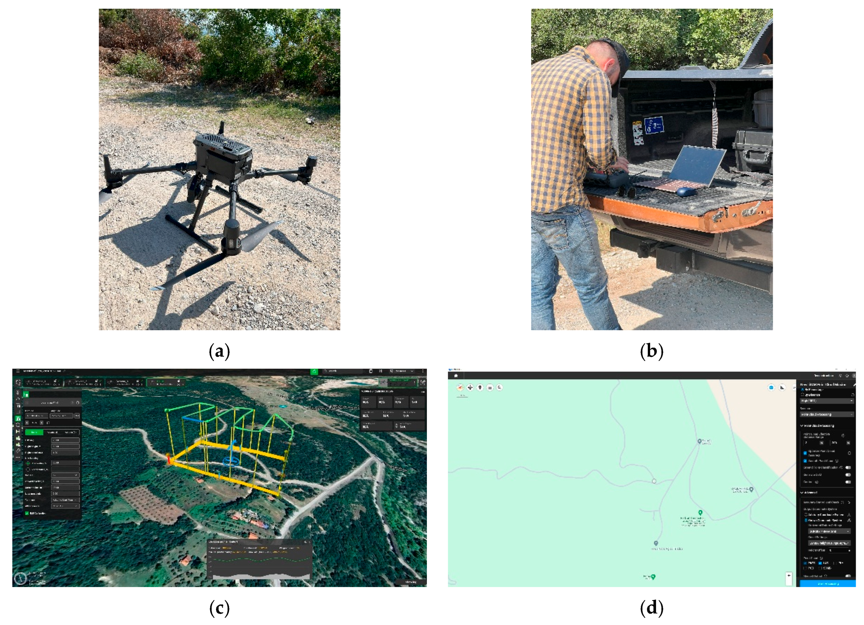
Airborne Laser Scanning (hereafter ALS) data acquisition was completed by means of a DJI Matrice 300 Real-Time Kinematic (RTK) Unmanned Aerial Vehicle (UAV) equipped with the DJI Zenmuse L2 Lidar camera (SZ DJI Technology Co., Ltd., Shenzhen, China) that exhibits five beam returns at 240 Hz and at a 90° beam angle (Appendix A). The UAV (Figure 2a–d) flew over the study area at an altitude of 80 m, at 6 m/sec flying speed, 70% and 80% side and front overlap, respectively, and a 40 m margin with repetitive pattern, acquiring a total of 114 images (point density of 285 points/m2. Four ground control points (GCPs) were set (three were needed for georeferencing a point cloud, and one more was added for control purposes [72]) with a GNSS device and RTK method. The GCPs were necessary for georeferencing the BLK2GO (Leica Geosystems AG, Heerbrugg, Switzerland), the Handheld Personal Laser System (hereafter HPLS) device, and the iPhone 13 Pro Max (hereafter iPhone) LiDAR point clouds.
First, the UAV LiDAR point cloud was processed in DJI Terra software version 5.0.1 (SZ DJI Technology Co., Ltd., Shenzhen, China) (Figure 2a–d) in order to optimize its accuracy and smooth and georeference it to GGRS87 (Greek Grid). The processing workflow continued by setting the geoid to the EGM96 height and generating an LAS point cloud and a True Digital Orthophoto (TDOM). The validity of the coordinates was confirmed in LiDAR360 V8.2 (GreenValley International Inc. (GVI), Berkeley, CA 94710, USA), where the LAS file was imported and the GCPs were checked. Next, a ground classification was performed, resulting in two classes, “Never Classified” and “Ground”. Then, a TIN was generated from the classified category “Ground” to confirm the classification process. A Digital Elevation Model (DEM) and a Digital Surface Model (DSM) were generated at a spatial resolution of 0.2 m, a necessary step for proceeding to the DEM accuracy assessment. The latter was conducted using the elevation mode, which generates an elevation error report between the point cloud and the GCPs. Finally, in PIX4Dmapper version 4.6.4 (Pix4D Inc., Denver, CO, USA), the acquired images were georeferenced to the local datum, and an orthomosaic was subsequently generated.

2.3. Mobile Laser Scanning Data Collection and Preprocess

The next step involved scanning the forest road with the BLK2GO HPLS device (Leica Geosystems AG, Heerbrugg, Switzerland) that combines three powerful SLAM methods—LiDAR, SLAM, and Visual SLAM—along with an Inertial Measurement Unit (IMU). BLK2GO was used as an MLS (Mobile Laser Scanner) to collect the spatial data of the surface road within the research site. The reported range of the sensor is 0.5 m to 25 m, with a system performance (GrandSLAM-based) accuracy of ±10 mm (Appendix A). The LiDAR data acquisition speed is up to 420,000 points per sec (pts/sec).
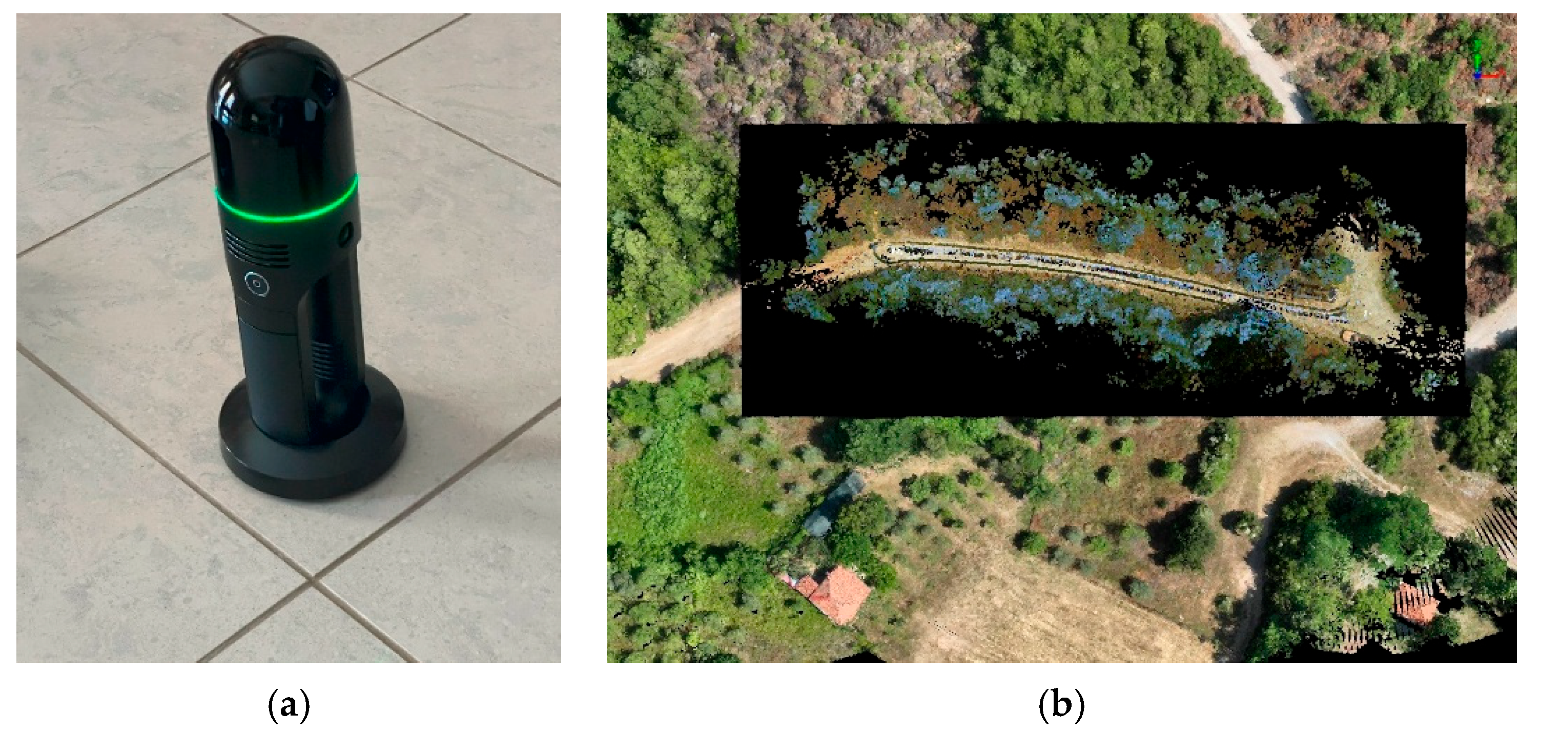
The MLS operator walked along the forest road at a speed of approximately 3 km/h, holding the instrument at a height of 1.40 m above the ground. The collected data were later extracted using the Cyclone REGISTER 360 PLUS (BLK Edition) TL software. HPLS systems usually do not have a GNSS receiver to provide absolute positioning; therefore, HPLS point clouds are usually produced in the local coordinate frame, which can be further georeferenced, i.e., rotated and translated, to a global geographical coordinate system in post-processing. The alignment, georeferencing, clipping, and cleaning of the SLAM point cloud were performed in LiDAR360 V8.2 based on the ALS LAS data and the four GCPs (Figure 3).

2.4. iPhone-Based Data Collection and Preprocessing

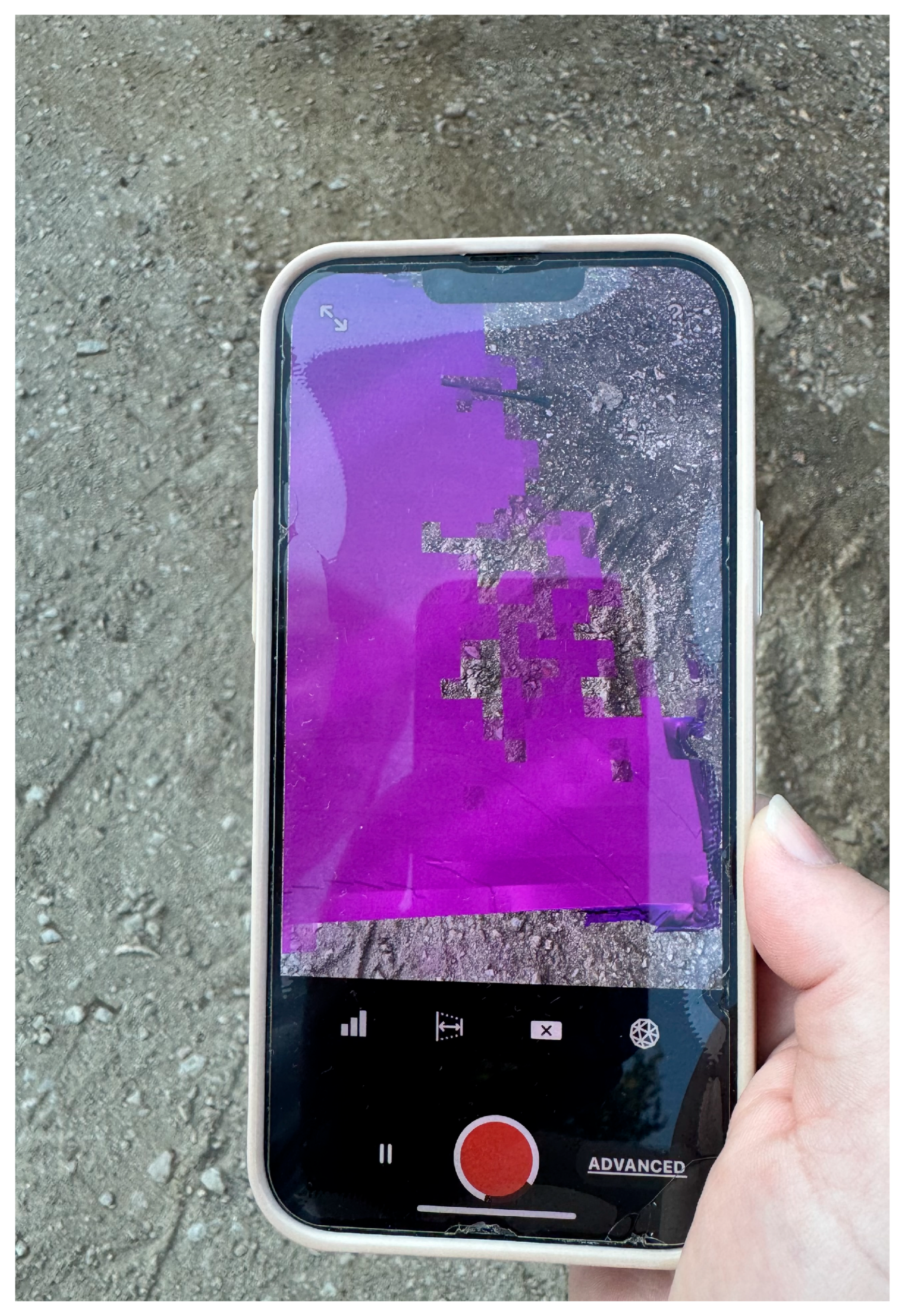
The forest road surface was scanned using an iPhone 13 Pro Max equipped with a LiDAR sensor (Appendix A) along with the 3D Scanner app for data acquisition (Figure 4). The collected LiDAR data were processed using CloudCompare (version 2.12.4). Initially, noise was removed using the statistical outlier removal (SOR) tool, and then the cleaned point cloud was aligned and georeferenced based on the ALS-derived LAS dataset.

2.5. Data Fusion of All Point Clouds

There are two main LiDAR data integration approaches: data-level fusion and feature-level fusion. In data-level fusion, datasets from different sensors (e.g., terrestrial and aerial LiDAR) are merged during preprocessing, before classification or feature extraction. Reference points are used to allow point cloud-to-point cloud alignment [73]. The quality of fused data is affected by the number of terrestrial scans, the scanner’s distance from the targeted locations, and forest conditions. Reflective targets can improve co-registration by mixing RGB pixel colors with terrestrial image and point cloud coordinates [74]. On the contrary, in feature-level fusion, data integration takes place after classification [75].
In this study, a data-level fusion approach was employed. The LAS files were merged in LiDAR360 (version 8.2) using the Point Cloud Tools, and outliers were removed. Then the data were smoothed with a maximum distance of 1 m and a search radius of 2 m using elevation smoothing, and ground points were classified by employing the CSF algorithm. Furthermore, DEMs and DSMs were generated with a cell size of 0.2 m using the Inverse Distance Weighting (IDW) and Kriging interpolation techniques to provide a comparative analysis of the two methodologies for the DEMs. A total of six point clouds were generated for further analysis: ALS, HPLS, iPhone, ALS + HPLS, ALS + iPhone, and HPLS + iPhone.

2.6. Data Collection Validation

The elevation accuracy of the forest road surface DEMs derived from ALS, SLAM, and iPhone 13 Pro Max LiDAR data was assessed through (a) comparison with ground-truth data obtained from field-measured GCPs using a GNSS device with the RTK method and (b) statistical analysis conducted using the LiDAR360 (version 8.2) software (Figure 5a,b).
To assess the suitability of these alternative methods for road design applications, it is necessary to consider the recommended accuracy standards for similar tasks. LiDAR data should be validated against a reference dataset of higher accuracy, such as data acquired through traditional surveying methods or high-resolution satellite imagery [76]. The point cloud density, which refers to the number of LiDAR points acquired per area unit, directly influences the level of detail and accuracy that can be achieved in the resulting road models. The resolution of the DTM or the DEM generated from the LiDAR point cloud determines the level of detail that can be captured in the terrain representation, influencing the accuracy of slope calculations, drainage analysis, and other applications [77].

3. Results

3.1. Comparative Analysis of Point Cloud Data

The UAV-derived LiDAR data offered extensive canopy-penetrating coverage with a consistent and high-density point cloud. The HPLS captured ground-level features with high spatial resolution, especially useful in areas under dense canopy, where UAV returns were comparatively sparse. The iPhone LiDAR, although limited in range and density compared to the other devices, contributed supplementary data for immediate visual feedback and accessible mapping.

3.1.1. Aerial Laser Scanning Data Generation

The UAV-generated point cloud consisted of 58,122,783 points, having a Mean Intensity of 60.565 ± 32.819. The generated TIN was later used for the production of the respective DEM, DSM, and Canopy Height Model (CHM), with the maximum tree height reaching 14.207 m in the study area (Figure 6a–d).

3.1.2. Comparison of Measurement Methods for Forest Road DEMs

The road profiles generated from each sensor are presented in Figure 7a–c as well as from the fused datasets, and their 3D visualizations are presented in Figure 8a–c.
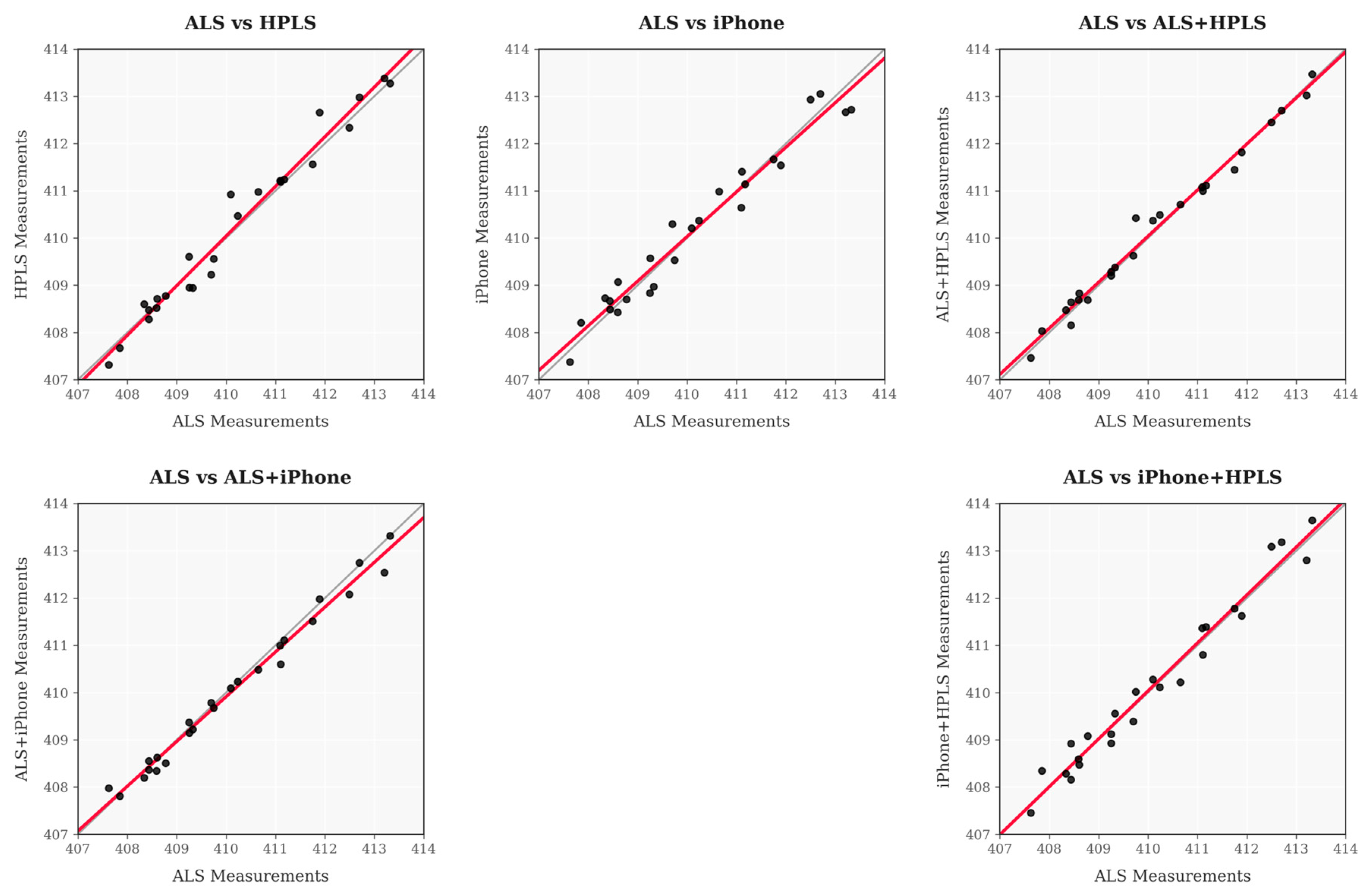
Figure 9 presents scatter plots comparing the elevation values of each method with those derived from ALS data. The black line represents perfect agreement (y = x), while the red line shows the actual regression line. The close alignment of these lines and the tight clustering of points around them indicate a strong level of agreement between the compared methods. It should be noted that the ALS + iPhone combination exhibits a particularly tight clustering around the perfect agreement line.
The pairwise comparison analysis (Table 2) between ALS data and each alternative method revealed notable differences in elevation between methods. ALS + iPhone showed the smallest deviation from ALS (MAE = 0.011, RMSE = 0.011, RE = 0.003%), whereas HPLS showed the largest deviation from ALS (MAE = 0.507, RMSE = 0.542, RE = 0.123%).

3.1.3. Sensor Performance Analysis for Forest Road Cross Sections

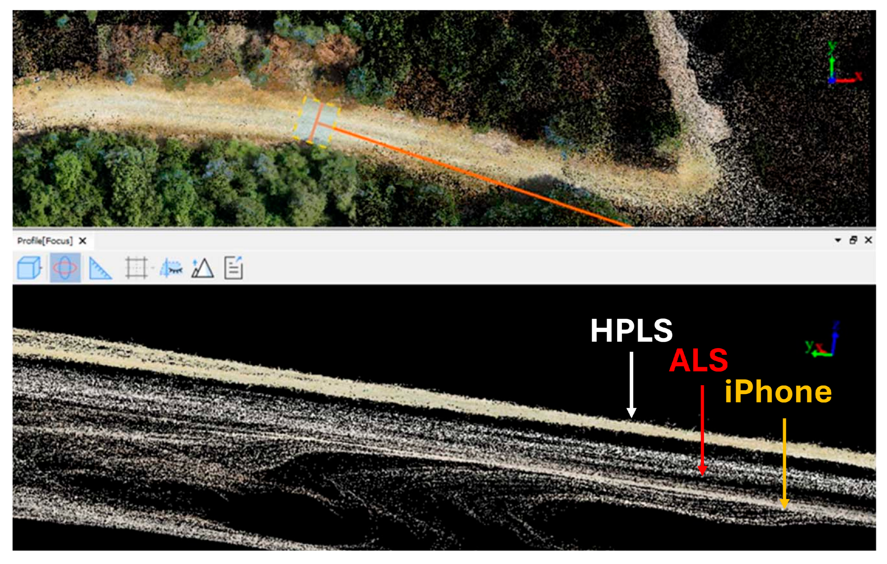
Cross-section profiles of the forest road acquired with different sensors, compared to ALS data, are visualized in Figure 9. Τhe HPLS point cloud is the most dense; however, the iPhone point cloud seems to be more closely aligned with the ALS point cloud (Figure 10).
Table 3 presents a comprehensive comparison of different sensor and interpolation method combinations for elevation measurements. The analysis includes correlation with other methods, consistency metrics, and overall reliability assessment.
ALS/IDW-Kriging shows the highest mean correlation (0.78), followed by iPhone + HPLS/IDW-Kriging (0.76) and ALS + iPhone/IDW-Kriging (0.72). Two iPhone-based methods, iPhone/Kriging and iPhone/IDW, show the lowest standard deviation (~0.007 m) but also the lowest range (~0.025 m), whereas ALS + iPhone/IDW-Kriging exhibits the highest standard deviation (0.077 m) and range (0.203 m) values. Local variation is relatively consistent across methods, with iPhone-based methods showing the lowest values, close to 0.002 m, and ALS + iPhone IDW-Kriging showing the highest (range 0.009–0.013 m).

3.1.4. Sensor Performance Analysis Across Different Terrain Conditions

Finally, sensor performance was analyzed (Table 4) across varying terrain conditions (Figure 11) by examining the data patterns and variations and considering elevation measurement consistency, slope calculation accuracy, and performance variation across different terrain types.
Performance analysis reveals that, on flat terrain (0–1% slope), median errors are very low (range 0.002–0.008 m/m), and gentle slopes (1–3%) show a modest error increase (range 0.015–0.03 m/m). Moderate slopes (3–5%) have medians of 0.035–0.05 m/m with narrow data spreads, whereas steep slopes (>5%) exhibit the highest variability, with median errors from 0.07 m/m up to roughly 0.22 m/m and maximum values near 0.32 m/m. This clear numerical progression confirms that terrain slope serves as a primary determinant of sensor accuracy, with measurement reliability declining proportionally as topographical complexity increases across all terrain categories.

3.2. Accuracy Analysis of Forest Road DEMs Based on GNSS RTK Measurements

The accuracy assessment of the generated DEMs was conducted using high-precision GNSS RTK measurements of the four GCPs (Table 5). The ALS + HPLS fusion yielded the highest precision, with an RMSE of 0.032 m, a mean error of 0.028 m, and a standard deviation of 0.020 m. The ALS dataset (forest road area) followed closely with an RMSE of 0.029 m. The ALS full-area dataset maintained reliable accuracy (RMSE: 0.057 m), supporting its use in broader forest road applications.
The HPLS-only dataset showed the highest RMSE (0.179 m), due to increased noise, despite its detailed ground capture. The iPhone LiDAR alone produced lower accuracy (RMSE: 0.111 m) and higher variability (SD: 0.121 m), while the iPhone + HPLS and ALS + iPhone combinations showed moderate improvement (RMSEs: 0.106 m and 0.108 m, respectively).

4. Discussion

An accurate representation of the terrain is essential for the design and maintenance of forest roads. Our study presents an in-depth evaluation of multiple LiDAR-based technologies, including Airborne Laser Scanning (ALS) using an UAV, Simultaneous Localization and Mapping (SLAM) using a Handheld Personal Laser Scanning (HPLS), and smartphone-based iPhone LiDAR, in addition to interpolation approaches such as Inverse Distance Weighting (IDW) and Kriging.
Previous studies compared laser scanning methods, such as TLS and SLAM, for (a) assessing forest road wearing course damage [25,54], (b) evaluating the elevation accuracy of DTMs in forest inventories and forest road characteristics derived from Aerial Imaging, Airborne Laser Scanning (ALS), and Mobile Laser Scanning (MLS) data [78,79,80], and (c) investigating forest stand attributes using TLS, MLS, and PLS data for the estimation of DBH, tree position, stem straightness and lean, detecting trees, tree height, crown base height (CBH), and crown projection area radii (CPAR), among others [72,81,82]. In contrast to these studies, our study focused on mapping a forest road and gravel and soil terrain using fused point clouds. The accuracy of the fused point clouds was assessed using (a) the ALS point cloud as reference data and (b) GCPs measured with a GNSS RTK device.
We first conducted a pairwise comparison analysis between ALS data (reference) and each alternative method to detect differences in elevation. The ALS + iPhone pairing showed the lowest deviation from ALS, with an extremely low MAE (0.011 m), RMSE (0.011 m), and RE (0.003%). These results suggest that the ALS and iPhone point clouds are compatible and of high quality. The iPhone’s consistent point distribution and reliable sensor calibration likely contribute to this result, making it a suitable complement to ALS for generating accurate DEMs. Two studies assessed forest road wearing course damage: Forkuo and Borz [54] also found strong compatibility between the iPhone 13 Pro Max and the professional Zeb Revo scanner (RMSE = 0.017 to 0.025 m for the 3D Scanner app), and Mikita et al. [25], using the Polycam with the iPhone 13 Pro, found RMSE values around 0.03 m. However, they emphasized that the iPhone 13 Pro equipped with LiDAR technology could be promising in capturing forest road surfaces with sufficient local accuracy; nevertheless, improvements are needed for length accuracy.
In comparison to ALS, HPLS exhibited the highest MAE (0.507 m), RMSE (0.542 m), and RE (0.13%) (See Table 2).
We also analyzed the reliability of elevation measurements using cross-section profiles of forest road. ALS alone demonstrated the highest mean correlation (0.7796), indicating excellent spatial consistency and reliability, making it the gold standard reference point cloud. ALS + iPhone data fusion maintained a strong performance (correlation = 0.7194), while having a higher variability (SD = 0.0771 m), suggesting that the integration of iPhone data preserves most of ALS’s quality but adds some noise. iPhone + HPLS fusion achieved a surprisingly high correlation (0.7570), nearly matching ALS performance. This finding indicates that data fusion using consumer-grade sensors can produce professional-quality and cost-effective results. In contrast, ALS + HPLS fusion showed the lowest correlation (0.4378) despite the employment of professional-grade equipment. This suggests that HPLS-derived data errors may significantly degrade the combined dataset quality. Nevertheless, our fused datasets maintained more realistic terrain heterogeneity compared to those obtained from individual sources.
Individual iPhone performance between interpolation methods, both IDW (0.4820) and Kriging (0.4875), shows similar correlations but extremely low variability metrics (SD = 0.0075–0.0076 m, 0.0021 m local variation), indicating highly consistent but potentially smoothed surfaces. HPLS alone shows moderate correlation (0.5556) with low variability, suggesting internal consistency but also an offset from reference data. In general, our results agree with Kardoš et al. [78], who found that interpolation techniques could be interchanged without significantly affecting elevation accuracy. These results demonstrate that data fusion can enhance DEM quality when compatible datasets are combined. If a dataset, such as HPLS, exhibits significant biases, these can distort the integrated result, as seen by the lower correlation in the ALS + HPLS fusion (Table 3).
Another important consideration was terrain slope. iPhone-based point clouds performed consistently on level ground (0–1% slope), but their accuracy suffered on steeper gradients. With HPLS providing useful cross-validation, ALS outperformed all other techniques for modest to high slopes (>3%). On gently sloping terrain (1–3%), combined methods showed the greatest benefit in balancing the strengths of several sensors. The research thus recommends the use of a terrain-specific method selection, involving the use of different equipment based on the performance of each sensor per gradient category (Table 4).
Another factor assessed was the accuracy of forest road DEMs based on GNSS RTK data for each method, including the quality of georeferencing and the accuracy of the forest road models. Our study revealed that HPLS alone demonstrated the highest error and variability, with a mean error of 0.119 m, a standard deviation of 0.163 m, and an RMSE of 0.179 m. This level of error suggests that HPLS may not be suitable for applications requiring high precision, as its measurements are both biased and inconsistent.
When ALS is combined with HPLS, performance improves dramatically. The ME drops to 0.028 m, SD to 0.020 m, and RMSE to 0.032 m. This indicates that integrating ALS with HPLS not only reduces bias but also narrows the spread of errors, making it highly reliable for precision-demanding tasks.
The iPhone, when used alone, shows moderate accuracy (ME = 0.036 m, RMSE = 0.111 m, SD = 0.121 m). iPhone LiDAR is good at capturing the height of roads, though it is not as precise in length measurements. Overall, iPhone LiDAR could be a very useful and affordable way to survey roads, and it offers fast data collection and mapping capabilities. Mikita et al. [25] suggest that the HPLS scanners (GeoSLAM ZEB Horizon and iPhone 13 Pro with apps) were able to accurately capture the current shape of forest road cross profiles but were not suitable for the design or material measurement needed for wearing course repair due to increased errors in horizontal (length) measurements.
Combining the iPhone with HPLS (ME = 0.054 m, RMSE = 0.106 m, SD = 0.105 m) or ALS (ME = 0.036 m, RMSE = 0.108 m, SD = 0.118 m) does not significantly improve performance, indicating that the iPhone’s limitations persist even when paired with other sensors. Using the ALS to map the full area offers a balanced solution (ME = −0.028 m, SD = 0.056 m, RMSE = 0.057 m). This level of accuracy is sufficient for most practical applications. The best performer in our research is using the ALS to map the forest road, which achieved the lowest errors across all metrics (ME = 0.021 m, SD = 0.025 m, RMSE = 0.029 m). These results are comparable to the results of a previous research, which reported RMSE values of ±0.03 m to ±0.04 m [78]. This system is exceptionally well suited for tasks demanding the highest accuracy and reliability, supporting the conclusions of Craven and Wing [79], who found that airborne LiDAR can accurately estimate forest road characteristics (RMSE = 0.28 m) (see Table 5).
Based on the measured error metrics and terrain analysis, our results can be used for practical sensor selection in forest road maintenance. ALS delivered the highest accuracy across all terrain types (RMSE~0.03 m), making it the preferred option for detailed planning and prioritization of repair work, particularly in steep or critical segments. iPhone LiDAR, with moderate error (RMSE~0.11 m), offered cost-effective and rapid assessment capabilities suitable for routine inspections or flat and gently sloping road sections where minor wearing is acceptable. HPLS, despite higher errors when used alone (RMSE~0.18 m), contributed valuable detail in canopy-covered areas when fused with ALS data, suggesting its role as a supplementary sensor in demanding forest conditions. These findings underscore the importance of selecting and combining technologies based on terrain complexity, maintenance goals, and available resources.
To further interpret these accuracy results in the context of forest road maintenance, typical thresholds for acceptable surface wear often range around 3–5 cm/m slope deviation to maintain safe drainage and vehicle access. Our ALS and ALS + iPhone fusion methods produced errors well below these thresholds (RMSE~0.03 m), supporting their suitability for planning and maintaining road segments where precise grading is essential. In contrast, iPhone-only scans may be adequate for identifying larger deformations or conducting fast inspections on flat to gently sloping sections, while HPLS alone may exceed acceptable limits on steeper slopes. Therefore, sensor selection should explicitly account for the required level of maintenance detail and local operational standards.

5. Conclusions

This study evaluated the operational effectiveness, accuracy, and overall performance of various LiDAR-based elevation and interpolation methods—both individually and through point cloud fusion—for forest road monitoring. No significant differences were observed between interpolation methods (IDW and Kriging). ALS data proved the most reliable, showing the highest correlation with ground control and balancing terrain sensitivity with consistency. Integrating ALS with iPhone 13 Pro Max or BLK2GO improved spatial data accuracy in complex terrain. However, standalone BLK2GO had the highest error, while iPhone data, despite the demonstrated low variance, tended to oversmooth topographic features.
Low-cost mobile LiDAR, particularly the iPhone 13 Pro Max with the 3D Scanner app, produced sufficiently accurate data for forest road surface mapping. Sensor performance varied by terrain: iPhone-based methods were best for flat areas, ALS for moderate slopes, and ALS-HPLS integration for steep terrain. Cross-validation using ALS data was essential for quality assurance in integrated workflows.
The results of this study indicate that higher sensor costs do not necessarily translate to greater accuracy. ALS-based methods, especially when ALS was used to map the forest road, provided the best cost–performance balance, while more expensive options like HPLS did not guarantee improved outcomes. For low-relief or short-term tasks, ALS and iPhone-based approaches offered strong accuracy-to-cost efficiency.
These results are also meaningful in a practical context, since the ALS and ALS + iPhone fusion methods achieved error levels well below typical maintenance thresholds (3–5 cm/m), supporting their use for planning and maintaining road segments with precise grading requirements.
iPhone LiDAR accuracy was found to be comparable to that of professional scanners such as BLK2GO and UAV LiDAR, confirming its potential as a cost-effective tool for road mapping in forest environments. However, this study was limited by the scarcity of comparable literature on fusion-based approaches using ALS, HPLS, and iPhone data. More analysis on the topic would be beneficial for forest managers to support their equipment purchase decisions. Furthermore, future research should explore real-time fusion workflows and evaluate long-term accuracy trends across different terrain conditions, forest road types, and vegetation scenarios.

Author Contributions

Conceptualization, E.S.; methodology, E.S.; software, E.S.; validation, E.S.; formal analysis, E.S. and V.P.; investigation, E.S.; writing—original draft preparation, E.S., V.P. and P.A.T.; writing—review and editing, E.S., V.P. and P.A.T.; visualization, E.S.; supervision, E.S. All authors have read and agreed to the published version of the manuscript.

Funding

This research received no external funding.

Data Availability Statement

Data are contained within the article.

Conflicts of Interest

The authors declare no conflict of interest.

Abbreviations

The following abbreviations are used in this manuscript:
LiDARLight Detection and Ranging
SLAMSimultaneous Localization and Mapping
HPLSHandheld Laser Scanner
DEMDigital Elevation Model
DSMDigital Surface Model
TDOMTrue Digital Orthophoto Map
ALSAirborne Laser Scanner
TLSTerrestrial Laser Scanning
UAVUnmanned Aerial Vehicle
GNSSGlobal Navigation Satellite System
RTKReal-Time Kinematic
GCPGround Control Point
IDWInverse Distance Weighting
CHMCanopy Height Model
MAEMean Absolute Error
RMSERoot Mean Square Error

Appendix A

Table A1. Sensor parameters.
ParameterEquipment
DJI Zenmuse L2 LiDAR SensorLeica BLK2GO HPLSiPhone 13 Pro Max LiDAR
ManufacturerDJILeica GeosystemsApple
Sensor TypeLivox LiDAR module (non-repetitive scanning)Multi-line (High-Speed) Pulsed Laser ScannerVCSEL-based ToF LiDAR
Laser ClassClass 1 (Eye-safe)Class 1 (Eye-safe)Class 1 (Eye-safe)
Wavelength905 nm830 nm ~940 nm
Range≤450 m (reflectivity-dependent)Up to 25 mUp to ~5 m (typical use)
Accuracy±5 cm @ 150 m10–20 mm @ 10 m~±1–2 cm (short-range, under ideal conditions)
Field of View70.4° × 77.2° (FOV of scanner)360° horizontal, ~270° vertical~120° horizontal
Scan Rate/Points per Second (pts/s)Max 240,000 pts/sUp to 420,000 pts/s~600,000 pts/s (raw capture)
Measurement PrincipleHybrid Time-of-Flight with APD receiverDirect time-of-flight pulsed laser scanningIndirect ToF (modulated VCSEL)
Inertial Measurement Unit (IMU)Integrated high-accuracy IMUHigh-grade SLAM IMU for 3D path trackingBuilt-in phone IMU (consumer-grade)
SLAM CapabilitySupported (RTK/IMU assisted)Yes (real-time 3D mapping)Software-based, limited (ARKit)
Weight~905 g (sensor only)~775 gEntire phone ~238 g
Power SourcePowered by drone Internal rechargeable battery (~45 min runtime)Phone battery
Primary Use CaseAerial LiDAR mapping with drone integrationMobile indoor/outdoor mapping, constructionAR apps, room scanning, small-scale modeling
Data OutputPoint cloud (LAS), intensity, GPS/IMU dataPoint cloud (E57, LAS, etc.)Depth map (ARKit), .USDZ, or .OBJ via apps

References

  1. Boston, K. The Potential Effects of Forest Roads on the Environment and Mitigating their Impacts. Curr. For. Rep. 2016, 2, 215–222. [Google Scholar] [CrossRef]
  2. Dadrasjavan, F.; Zarrinpanjeh, N.; Ameri, A. Automatic Crack Detection of Road Pavement Based on Aerial UAV Imagery. preprint 2019, 2019070009 (v1). [Google Scholar] [CrossRef]
  3. Dodson, E.M. Challenges in Forest Road Maintenance in North America. Croat. J. For. Eng. 2021, 42, 107–116. [Google Scholar] [CrossRef]
  4. Kweon, H.; Seo, J.I.; Lee, J.-W. Assessing the Applicability of Mobile Laser Scanning for Mapping Forest Roads in the Republic of Korea. Remote Sens. 2020, 12, 1502. [Google Scholar] [CrossRef]
  5. Marchi, E.; Chung, W.; Visser, R.; Abbas, D.; Nordfjell, T.; Mederski, P.S.; McEwan, A.; Brink, M.; Laschi, A. Sustainable Forest Operations (SFO): A new paradigm in a changing world and climate. Sci. Total Environ. 2018, 634, 1385–1397. [Google Scholar] [CrossRef]
  6. Picchio, R.; Latterini, F.; Mederski, P.S.; Tocci, D.; Venanzi, R.; Stefanoni, W.; Pari, L. Applications of GIS-Based Software to Improve the Sustainability of a Forwarding Operation in Central Italy. Sustainability 2020, 12, 5716. [Google Scholar] [CrossRef]
  7. Tan, Y.; Li, Y. UAV Photogrammetry-Based 3D Road Distress Detection. ISPRS Int. J. Geo-Inf. 2019, 8, 409. [Google Scholar] [CrossRef]
  8. Toscani, P.; Sekot, W.; Holzleitner, F. Forest Roads from the Perspective of Managerial Accounting—Empirical Evidence from Austria. Forests 2020, 11, 378. [Google Scholar] [CrossRef]
  9. Xu, Q.; Li, M.; Jiang, X.; Zhang, Z.; Jiao, J.; Jian, J.; Li, J.; Yan, X.; Liang, Y.; Chen, T.; et al. Response of rill erosion to rainfall types and maintenance on the Loess Plateau: Implications for road erosion control. Catena 2022, 219, 106642. [Google Scholar] [CrossRef]
  10. Korpinen, O.-J.; Aalto, M.; Venäläinen, P.; Ranta, T. Impacts of a High-Capacity Truck Transportation System on the Economy and Traffic Intensity of Pulpwood Supply in Southeast Finland. Croat. J. For. Eng. 2019, 40, 89–105. [Google Scholar]
  11. Siafali, E.; Tsioras, P.A. Surface Deformation Monitoring in Forest Road Networks: A High Precision UAV Real-Time Kinematic Approach. In Proceedings of the Research and Practice in Forest Ecology, Kórnik, Poland, 8–12 May 2024; p. 181. [Google Scholar]
  12. Heinimann, H.R. Forest Road Network and Transportation Engineering–State and Perspectives. Croat. J. For. Eng. 2017, 38, 155–173. [Google Scholar]
  13. Stefanović, B.; Stojnić, D.; Danilović, M. Multi-criteria forest road network planning in fire-prone environment: A case study in Serbia. J. Environ. Plan. Manag. 2016, 59, 911–926. [Google Scholar] [CrossRef]
  14. Latterini, F.; Dyderski, M.K.; Horodecki, P.; Picchio, R.; Venanzi, R.; Lapin, K.; Jagodziński, A.M. The Effects of Forest Operations and Silvicultural Treatments on Litter Decomposition Rate: A Meta-analysis. Curr. For. Rep. 2023, 9, 276–290. [Google Scholar] [CrossRef]
  15. Siafali, E.; Tsioras, P.A. An Innovative Approach to Surface Deformation Estimation in Forest Road and Trail Networks Using Unmanned Aerial Vehicle Real-Time Kinematic-Derived Data for Monitoring and Maintenance. Forests 2024, 15, 212. [Google Scholar] [CrossRef]
  16. Marion, Y.F.; Eagleston, H.; Burroughs, K. A review and synthesis of recreation ecology research findings on visitor impacts to wilderness and protected natural areas. J. For. 2016, 114, 352–362. [Google Scholar] [CrossRef]
  17. Leung, Y.F.; Newburger, T.; Jones, M.; Kuhn, B.; Woiderski, B. Developing a monitoring protocol for visitor-created informal trails in Yosemite National Park, USA. Environ. Manag. 2011, 47, 93–106. [Google Scholar] [CrossRef]
  18. Ramos-Scharrón, C.E.; Alicea-Díaz, E.E.; Figueroa-Sánchez, Y.A.; Viqueira-Ríos, R. Road cutslope erosion and control treatments in an actively-cultivated tropical montane setting. Catena 2022, 209, 105814. [Google Scholar] [CrossRef]
  19. Acuna, M. Timber and Biomass Transport Optimization: A Review of Planning Issues, Solution Techniques and Decision Support Tools. Croat. J. For. Eng. 2017, 38, 279–290. [Google Scholar]
  20. Siafali, E.; Tsioras, P.A. Uav-Enabled Deformation Classification and Earthworks Assessment For Sustainable Wood Extraction Management. In Proceedings of the FORMEC 2024: Timber Harvesting: The Reality of Offsetting the Needs of Industry Against Those of the Environment, Gdańsk, Poland, 11–14 June 2024; p. 167. [Google Scholar]
  21. Siafali, E. Implementation of Innovative Technologies in Surveying, Projecting, and Managing Hiking Trails. Ph.D. Thesis, Aristotle University of Thessaloniki, Thessaloniki, Greece, 2023. [Google Scholar]
  22. Mederski, P.S.; Borz, S.A.; Đuka, A.; Lazdiņš, A. Challenges in Forestry and Forest Engineering: Case Studies from Four Countries in East Europe. Croat. J. For. Eng. 2021, 42, 117–134. [Google Scholar] [CrossRef]
  23. Malladi, K.T.; Quirion-Blais, O.; Sowlati, T. Development of a decision support tool for optimizing the short-term logistics of forest-based biomass. Appl. Energy 2018, 216, 662–677. [Google Scholar] [CrossRef]
  24. Karagiannis, E. Evaluation of road opening up in Greek forests. In Scientific Yearbook; School of Forestry and Natural Environment: Thessaloniki, Greece, 2008; pp. 714–727. [Google Scholar]
  25. Mikita, T.; Krausková, D.; Hrůza, P.; Cibulka, M.; Patočka, Z. Forest Road Wearing Course Damage Assessment Possibilities with Different Types of Laser Scanning Methods including New iPhone LiDAR Scanning Apps. Forests 2022, 13, 1763. [Google Scholar] [CrossRef]
  26. Talbot, B.; Astrup, R. A review of sensors, sensor-platforms and methods used in 3D modelling of soil displacement after timber harvesting. Croat. J. For. Eng. 2021, 42, 149–164. [Google Scholar] [CrossRef]
  27. Akgul, M.; Yurtseven, H.; Akburak, S.; Demir, M.; Cigizoglu, H.K.; Ozturk, T.; Eksi, M.; Akay, A.O. Short term moniterning of forest road pavement degradation using terrestrial laser scanning. Measurement 2017, 103, 283–293. [Google Scholar] [CrossRef]
  28. Akgul, M.; Akburak, S.; Yurtseven, H.; Akay, A.O.; Cigizoglu, H.K.; Demir, M.; Ozturk, T.; Eksi, M. Potential Impacts of Weather and Traffic Conditions on Road Surface Performance in Terms of Forest Operations Continuity. Appl. Ecol. Environ. Res. 2019, 17, 2533–2550. [Google Scholar] [CrossRef]
  29. Mercier, P.; Aas, G.; Dengler, J. Effects of skid trails on understory vegetation in forests: A case study from Northern Bavaria (Germany). For. Ecol. Manag. 2019, 453, 117579. [Google Scholar] [CrossRef]
  30. Correia, P.; Oliveira, H. Automatic Road Crack Segmentation Using Entropy and Image Dynamic Thresholding. In Proceedings of the European Signal Processing Conference (EUSIPCO 2009), Glasgow, UK, 24–28 August 2009. [Google Scholar]
  31. Sadeghi, S.; Ahmad, S.; Tsioras, P.A. Effects of traffic intensity and travel speed on forest soil disturbance at different soil moisture conditions. Int. J. For. Eng. 2022, 33, 146–154. [Google Scholar] [CrossRef]
  32. Jourgholami, M.; Hansson, L.J.; Högbom, L.; Jourgholami, M.; Laschi, A. Strategies to Mitigate the Effects of Soil Physical Disturbances Caused by Forest Machinery: A Comprehensive Review. Curr. For. Rep. 2022, 8, 20–37. [Google Scholar] [CrossRef]
  33. Jourgholami, M.; Majnounain, B.; Etehadi Abari, M. Effects of tree-length timber skidding on soil compaction in the skid trail in Hyrcanian forests. For. Syst. 2014, 23, 288–293. [Google Scholar] [CrossRef]
  34. Marchi, R.; Spinelli, R.; Verani, S.; Venanzi, R.; Certini, G.E.; Picchio, R. Environmental impact assessment of different logging methods in pine forests thinning. Ecol. Eng. 2014, 70, 429–436. [Google Scholar] [CrossRef]
  35. Solgi, A.; Naghdi, R.; Zenner, E.K.; Hemmati, V.; Behjou, F.K.; Masumian, A. Evaluating the Effectiveness of Mulching for Reducing Soil Erosion in Cut Slope and Fill Slope of Forest Roads in Hyrcanian Forests. Croat. J. For. Eng. 2021, 42, 259–268. [Google Scholar] [CrossRef]
  36. Gibson, K.S.; Neher, D.A.; Johnson, N.C.; Parmenter, R.R.; Antoninka, A.J. Heavy Logging Machinery Impacts Soil Physical Properties More than Nematode Communities. Forests 2023, 14, 1205. [Google Scholar] [CrossRef]
  37. Picchio, R.; Mederski, P.S.; Tavankar, F. How and How Much, Do Harvesting Activities Affect Forest Soil, Regeneration and Stands? Curr. For. Rep. 2020, 6, 115–128. [Google Scholar] [CrossRef]
  38. Sherba, J.; Blesius, L.; Davis, J. Object-Based Classification of Abandoned Logging Roads under Heavy Canopy Using LiDAR. Remote Sens. 2014, 6, 4043–4060. [Google Scholar] [CrossRef]
  39. Waga, K.; Tompalski, P.; Coops, N.C.; White, J.C.; Wulder, M.A.; Malinen, J.; Tokola, T. Forest Road Status Assessment Using Airborne Laser Scanning. For. Sci. 2020, 66, 501–508. [Google Scholar] [CrossRef]
  40. Kiss, K.; Malinen, J.; Tokola, T. Forest road quality control using ALS data. Can. J. For. Res. 2015, 45, 1636–1642. [Google Scholar] [CrossRef]
  41. Luetzenburg, G.; Kroon, A.; Bjørk, A.A. Evaluation of the Apple iPhone 12 Pro LiDAR for an Application in Geosciences. Sci. Rep. 2021, 11, 22221. [Google Scholar] [CrossRef]
  42. Aldea, S.E.; Le Hégarat-Mascle, S. Robust crack detection for unmanned aerial vehicles inspection in an 409 a-contrario decision framework. J. Electron. Imaging 2015, 24, 061119. [Google Scholar] [CrossRef]
  43. Grandsaert, P.J. Integrating Pavement Crack Detection and Analysis Using Autonomous Unmanned Aerial Vehicle Imagery; Air Force Institute of Technology: Greene, OH, USA, 2015.
  44. Sankarasrinivasan, S.; Balasubramanian, E.; Karthik, K.; Chandrasekar, U.; Gupta, R.S. Health Monitoring of Civil Structures with Integrated UAV and Image Processing System. In Proceedings of the 11th International Multi-Conference on Information Processing, Bangalore, India, 21–23 August 2015; pp. 508–515. [Google Scholar]
  45. Alfio, V.S.; Costantino, D.; Pepe, M. Influence of Image TIFF Format and JPEG Compression Level in the Accuracy of the 3D Model and Quality of the Orthophoto in UAV Photogrammetry. J. Imaging 2020, 6, 30. [Google Scholar] [CrossRef]
  46. Manajitprasert, S.; Tripathi, N.K.; Arunplod, S. Three-Dimensional (3D) Modeling of Cultural Heritage Site Using UAV Imagery: A Case Study of the Pagodas in Wat Maha That, Thailand. Appl. Sci. 2019, 9, 3640. [Google Scholar] [CrossRef]
  47. Kim, I.; Seo, J.; Woo, H.; Choi, B. Assessing Rutting and Soil Compaction Caused by Wood Extraction Using Traditional and Remote Sensing Methods. Forests 2025, 16, 86. [Google Scholar] [CrossRef]
  48. Kweon, H. Comparisons of Estimated nCircuity Factor of Forest Roads with Different Vertical Heights in Mountainous Areas, Republic of Korea. Forests 2019, 10, 1147. [Google Scholar] [CrossRef]
  49. Hoseini, M.; Puliti, S.; Hoffmann, S.; Astrup, R. Pothole detection in the woods: A deep learning approach for forest road surface monitoring with dashcams. Int. J. For. Eng. 2024, 35, 303–312. [Google Scholar] [CrossRef]
  50. Biçici, S.; Zeybek, M. An approach for the automated extraction of road surface distress from a UAV-derived point cloud. Autom. Constr. 2021, 122, 103475. [Google Scholar] [CrossRef]
  51. Baiocchi, V.; Del Pizzo, S.; Monti, F.; Pugliano, G.; Onori, M.; Robustelli, U.; Troisi, S.; Vatore, F.; León Trujillo, F.J. Solutions and limitations of the geomatic survey of an archaeological site in hard to access areas with a latest generation smartphone: The example of the Intihuatana stone in Machu Picchu (Peru). Acta IMEKO 2022, 11, 8. [Google Scholar] [CrossRef]
  52. Díaz-Vilariño, L.; Tran, H.; Frías, E.; Balado, J.; Khoshelham, K. 3D mapping of indoor and outdoor environments using Apple smart devices. Int. Arch. Photogramm. Remote Sens. Spat. Inf. Sci. 2022, XLIII-B4-2022, 303–308. [Google Scholar] [CrossRef]
  53. Zhu, L.; Zhang, H.; Li, X.; Zhu, F.; Liu, Y. GNSS Timing Performance Assessment and Results Analysis. Sensors 2022, 22, 2486. [Google Scholar] [CrossRef]
  54. Forkuo, G.O.; Borz, S.A. Accuracy and inter-cloud precision of low-cost mobile LiDAR technology in estimating soil disturbance in forest operations. Front. For. Glob. Change 2023, 6, 1224575. [Google Scholar] [CrossRef]
  55. Nakagomi, H.; Fuse, Y.; Nagata, Y.; Hosaka, H.; Miyamoto, H.; Yokozuka, M.; Kamimura, A.; Watanabe, H.; Tanzawa, T.; Kotani, S. Forest road surface detection using LiDAR-SLAM and U-Net. In Proceedings of the 2021 IEEE/SICE International Symposium on System Integration, SII 2021, Iwaki, Japan, 11–14 January 2021; pp. 727–732. [Google Scholar]
  56. Tomaštík, J.; Tomaštík, J.; Saloň, Š.; Piroh, R. Horizontal accuracy and applicability of smartphone GNSS positioning in forests. For. Int. J. For. Res. 2016, 90, 187–198. [Google Scholar] [CrossRef]
  57. Kukko, A.; Kaijaluoto, R.; Kaartinen, H.; Lehtola, V.V.; Jaakkola, A.; Hyyppä, J. Graph SLAM correction for single scanner MLS forest data under boreal forest canopy. ISPRS J. Photogramm. Remote Sens. 2017, 132, 199–209. [Google Scholar] [CrossRef]
  58. Shao, J.; Zhang, W.; Mellado, N.; Wang, N.; Jin, S.; Cai, S.; Luo, L.; Lejemble, T.; Yan, G. SLAM-aided forest plot mapping combining terrestrial and mobile laser scanning. ISPRS J. Photogramm. Remote Sens. 2020, 163, 214–230. [Google Scholar] [CrossRef]
  59. Zhou, T.; Zhao, C.; Wingren, C.P.; Fei, S.; Habib, A. Forest feature LiDAR SLAM (F2-LSLAM) for backpack systems. ISPRS J. Photogramm. Remote Sens. 2024, 212, 96–121. [Google Scholar] [CrossRef]
  60. Pierzchała, M.; Giguère, P.; Astrup, R. Mapping forests using an unmanned ground vehicle with 3D LiDAR and graph-SLAM. Comput. Electron. Agric. 2018, 145, 217–225. [Google Scholar] [CrossRef]
  61. Azizi, Z.; Najafi, A.; Sadeghian, S. Forest Road Detection Using LiDAR Data. J. For. Res. 2014, 25, 975–980. [Google Scholar] [CrossRef]
  62. Türk, Y.; Özçelik, V.; Akduman, E. Capabilities of using UAVs and close range photogrammetry to determine short-term soil losses in forest road cut slopes in semi-arid mountainous areas. Environ. Monit. Assess. 2024, 196, 149. [Google Scholar] [CrossRef] [PubMed]
  63. Hruza, T.; Tyagur, N.; Krejza, Z.; Cibulka, M.; Procházková, A.; Patocka, Z. Detecting Forest Road Wearing Course Damage Using Different Methods of Remote Sensing. Remote Sens. 2018, 10, 492. [Google Scholar] [CrossRef]
  64. Buján, S.; Guerra-Hernández, J.; González-Ferreiro, E.; Miranda, D. Forest Road Detection Using LiDAR Data and Hybrid Classification. Remote Sens. 2021, 13, 393. [Google Scholar] [CrossRef]
  65. Yadav, Y.; Kushwaha, S.K.P.; Mokros, M.; Chudá, J.; Pondelík, M. Intergration of iPhone LiDAR with quadcopter and fixed wing UAV Photogrammetry for the forest applications. Int. Arch. Photogramm. Remote Sens. Spat. Inf. Sci. 2023, XLVIII-1/W3-2023, 213–218. [Google Scholar] [CrossRef]
  66. Khanal, M.; Hasan, M.; Sterbentz, N.; Johnson, R.; Weatherly, J. Accuracy Comparison of Aerial Lidar, Mobile-Terrestrial Lidar, and UAV Photogrammetric Capture Data Elevations over Different Terrain Types. Infrastructures 2020, 5, 65. [Google Scholar] [CrossRef]
  67. Qian, C.; Liu, H.; Tang, J.; Chen, Y.; Kaartinen, H.; Kukko, A.; Zhu, L.; Liang, X.; Chen, L.; Hyyppä, J. An Integrated GNSS/INS/LiDAR-SLAM Positioning Method for Highly Accurate Forest Stem Mapping. Remote Sens. 2016, 9, 3. [Google Scholar] [CrossRef]
  68. Zhou, R.; Sun, H.; Ma, K.; Tang, J.; Chen, S.; Fu, L.; Liu, Q. Improving Estimation of Tree Parameters by Fusing ALS and TLS Point Cloud Data Based on Canopy Gap Shape Feature Points. Drones 2023, 7, 524. [Google Scholar] [CrossRef]
  69. Muhojoki, J.; Tavi, D.; Hyyppä, E.; Lehtomäki, M.; Faitli, T.; Kaartinen, H.; Kukko, A.; Hakala, T.; Hyyppä, J. Benchmarking Under- and Above-Canopy Laser Scanning Solutions for Deriving Stem Curve and Volume in Easy and Difficult Boreal Forest Conditions. Remote Sens. 2024, 16, 1721. [Google Scholar] [CrossRef]
  70. Chen, J.; Zhao, D.; Zheng, Z.; Xu, C.; Pang, Y.; Zeng, Y. A clustering-based automatic registration of UAV and terrestrial LiDAR forest point clouds. Comput. Electron. Agric. 2024, 217, 108648. [Google Scholar] [CrossRef]
  71. Bugday, E.; Akay, A.E. Determination of the Forest Road Alignment in Landslide-Prone Areas based on Landslide Susceptibility Map Generated by Machine Learning Approaches. In Proceedings of the COFE-FETEC 2023—Forest Operations: A Tool for Forest Management, Flagstaff, AZ, USA, 23–25 May 2023. [Google Scholar]
  72. Balenović, I.; Liang, X.; Jurjević, L.; Hyyppä, J.; Seletković, A.; Kukko, A. Hand-Held Personal Laser Scanning: Current Status and Perspectives for Forest Inventory Application. Croat. J. For. Eng. 2021, 42, 165–183. [Google Scholar] [CrossRef]
  73. Balestra, M.; Tonelli, E.; Vitali, A.; Urbinati, C.; Frontoni, E.; Pierdicca, R. Geomatic Data Fusion for 3D Tree Modeling: The Case Study of Monumental Chestnut Trees. Remote. Sens. 2023, 15, 2197. [Google Scholar] [CrossRef]
  74. Dandois, J.P.; Baker, M.; Olano, M.; Parker, G.G.; Ellis, E.C. What is the Point? Evaluating the Structure, Color, and Semantic Traits of Computer Vision Point Clouds of Vegetation. Remote. Sens. 2017, 9, 355. [Google Scholar] [CrossRef]
  75. Dalponte, M.; Ørka, H.O.; Ene, L.T.; Gobakken, T.; Næsset, E. Tree crown delineation and tree species classification in boreal forests using hyperspectral and ALS data. Remote Sens. Environ. 2014, 140, 306–317. [Google Scholar] [CrossRef]
  76. Morais, J.D.; Faria, T.S.; Elmiro, M.A.T.; Nero, M.A.; Silva, A.A.; Nobrega, R.A.A. Altimetry assessment of aster GDEM v2 and SRTM v3 digital elevation models: A case study in urban area of Belo Horizonte, MG, Brazil. Bol. Cienc. Geod. 2017, 23, 654–668. [Google Scholar] [CrossRef]
  77. White, R.A.; Dietterick, B.C.; Mastin, T.; Strohman, R. Forest Roads Mapped Using LiDAR in Steep Forested Terrain. Remote Sens. 2010, 2, 1120–1141. [Google Scholar] [CrossRef]
  78. Kardoš, M.; Sačkov, I.; Tomaštík, J.; Basista, I.; Borowski, Ł.; Ferenčík, M. Elevation Accuracy of Forest Road Maps Derived from Aerial Imaging, Airborne Laser Scanning and Mobile Laser Scanning Data. Forests 2024, 15, 840. [Google Scholar] [CrossRef]
  79. Craven, M.; Wing, M.G. Applying airborne LiDAR for forested road geomatics. Scand. J. For. Res. 2014, 29, 174–182. [Google Scholar] [CrossRef]
  80. Mikita, T.; Janata, P.; Surový, P. Forest Stand Inventory Based on Combined Aerial and Terrestrial Close-Range Photogrammetry. Forests 2016, 7, 165. [Google Scholar] [CrossRef]
  81. Ryding, J.; Williams, E.; Smith, M.J.; Eichhorn, M.P. Assessing Handheld Mobile Laser Scanners for Forest Surveys. Remote. Sens. 2015, 7, 1095–1111. [Google Scholar] [CrossRef]
  82. Cabo, C.; Del Pozo, S.; Rodríguez-Gonzálvez, P.; Ordóñez, C.; González-Aguilera, D. Comparing Terrestrial Laser Scanning (TLS) and Wearable Laser Scanning (WLS) for Individual Tree Modeling at Plot Level. Remote Sens. 2018, 10, 540. [Google Scholar] [CrossRef]
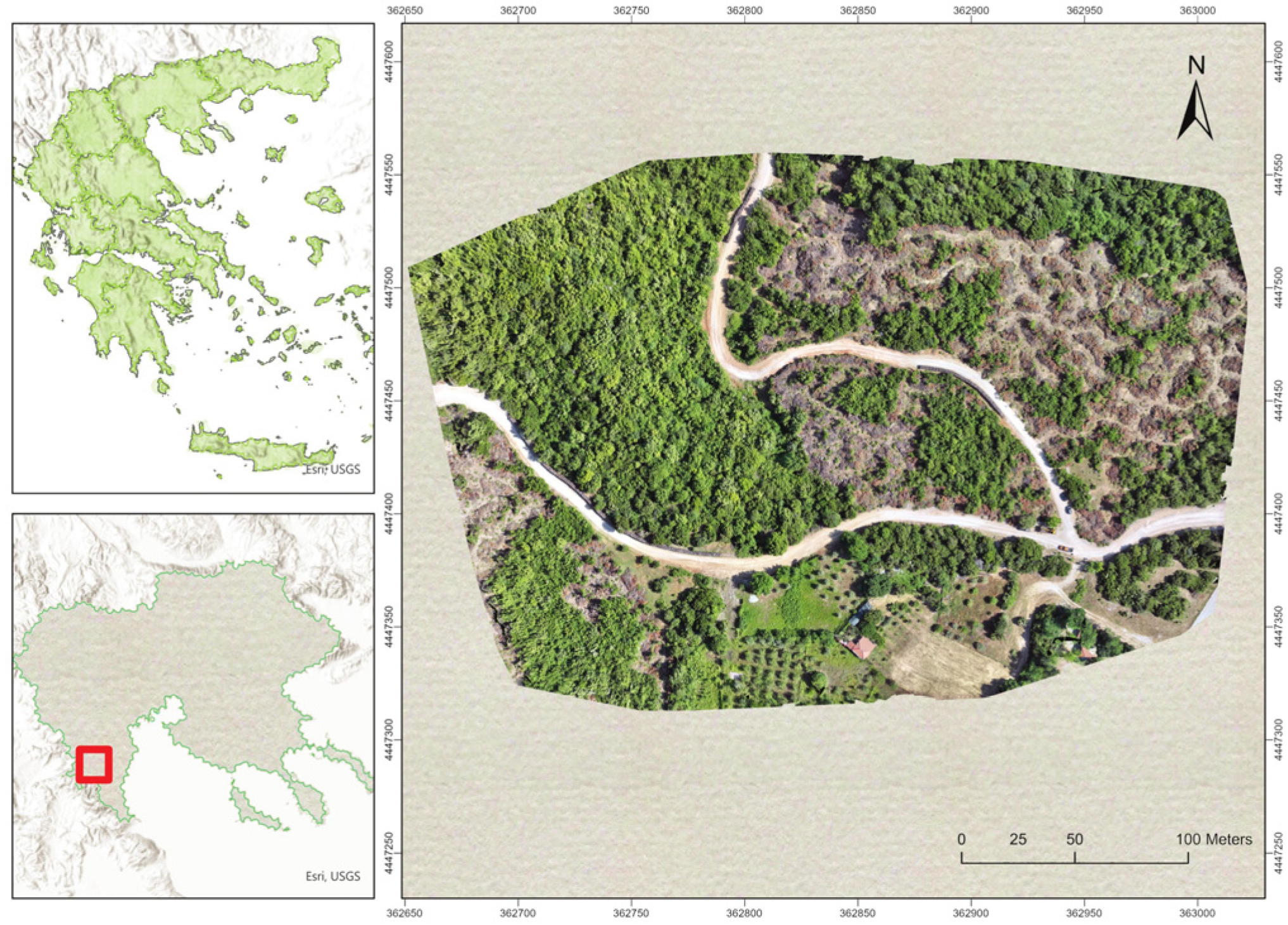
Figure 1. Study area—Mount Olympus National Park.
Land 14 01553 g001
Figure 2. (a) The DJI Matrice 300 Real-Time Kinematic (RTK) Unmanned Aerial Vehicle (UAV) equipped with the DJI Zenmuse L2 Lidar camera; (b) preparation of the flight; (c) screen capture of the UAV controller; (d) processing of the UAV LiDAR point cloud in DJI Terra software version 5.0.1.
Land 14 01553 g002
Figure 3. (a) The BLK2GO HPLS device; (b) preprocessed HPLS point cloud prior to noise filtering. The figure demonstrates that the point cloud has already been georeferenced and is precisely aligned with the ALS point cloud.
Land 14 01553 g003
Figure 4. Data collection using the LiDAR sensor of iPhone 13 Pro Max.
Land 14 01553 g004
Figure 5. (a) One of the GCPs (stacked firewood pile) used for the study; (b) zoomed image of the same GCP.
Land 14 01553 g005
Figure 6. (a) Triangulated Irregular Network (TIN) generated for the creation of the (b) Digital Surface Model (DSM), (c) Digital Elevation Model (DEM), and (d) Canopy Height Model (CHM) of the study area.
Land 14 01553 g006
Figure 7. Road profiles generated from (a) Aerial Laser Scanning, (b) the Handheld Personal Laser Scanner, and (c) the iPhone 13 Pro Max.
Land 14 01553 g007
Figure 8. Fused point cloud profiles of forest road generated from (a) ALS + HPLS; (b) iPhone + HPLS; and (c) ALS + HPLS + iPhone.
Land 14 01553 g008
Figure 9. Scatter plots comparing elevation measurements from each method with those obtained from ALS data. The black line represents perfect agreement (y = x), while the red line shows the actual regression line.
Land 14 01553 g009
Figure 10. Road cross-section profile derived from ALS, HPLS, and iPhone datasets.
Land 14 01553 g010
Figure 11. Sensor/Interpolation method combination performance across different slope conditions.
Land 14 01553 g011
Table 1. Information summary of the examined forest road.
Road class *B
Type of materialGravel and soil
Construction year1994
Year of last maintenance2023
Length (m)608
Road width (m)4–6
Maximum longitudinal downhill slope (%) 8
Maximum longitudinal uphill slope (%)6
Radius of curvature in maneuvers (m)20
Average slope (%)6
* According to technical specifications of Greece (41287/2281/22-5-73, 92833/4679/1-12-97).
Table 2. Detailed pairwise comparison statistics using ALS as reference data.
MethodMAERMSERelative Error (%)
HPLS0.5070.5420.123
iPhone0.2290.2790.056
ALS + HPLS0.3460.4870.084
ALS + iPhone0.0110.0110.003
iPhone + HPLS0.3800.4900.092
Table 3. Performance comparison of different sensor and interpolation method combinations for DEM generation.
Sensor/Interpolation Method CombinationMean CorrelationStandard Deviation
(m)
Range
(m)
Local Variation (m)
ALS/IDW-Kriging0.77960.4140.13920.0107
ALS + HPLS/IDW-Kriging0.43780.02310.08390.0093
ALS + iPhone/IDW-Kriging0.71940.07710.20320.0131
HPLS/IDW-Kriging0.55560.02430.09580.0100
iPhone/IDW0.48200.00760.02730.0021
iPhone/Kriging0.48750.00750.02480.0021
iPhone + HPLS/IDW-Kriging0.75700.04380.15320.0104
Table 4. Terrain analysis matrix of sensor performance.
Terrain ClassSlope RangeElevation
Measurement Consistency
Calculation
Accuracy
Performance
Characteristics
Flat terrain0–1%HighVery highOptimal performance
Gentle slopes1–3%GoodHighGood performance
Moderate slopes3–5%ModerateModerateRequires attention
Steep slopes>5%VariableChallengingNeeds special consideration
Table 5. Statistical analysis of errors for each sensor.
MethodMean Error (m)Std Dev (m)RMSE (m)
ALS/Full area−0.0280.0560.057
ALS/Forest road0.0210.0250.029
ALS + HPLS0.0280.0200.032
ALS + iPhone0.0360.1180.108
HPLS0.1190.1630.179
iPhone0.0360.1210.111
iPhone + HPLS0.0540.1050.106
Disclaimer/Publisher’s Note: The statements, opinions and data contained in all publications are solely those of the individual author(s) and contributor(s) and not of MDPI and/or the editor(s). MDPI and/or the editor(s) disclaim responsibility for any injury to people or property resulting from any ideas, methods, instructions or products referred to in the content.