GIS-Based Flood Susceptibility Mapping Using AHP in the Urban Amazon: A Case Study of Ananindeua, Brazil
Abstract
1. Introduction
2. Materials and Methods
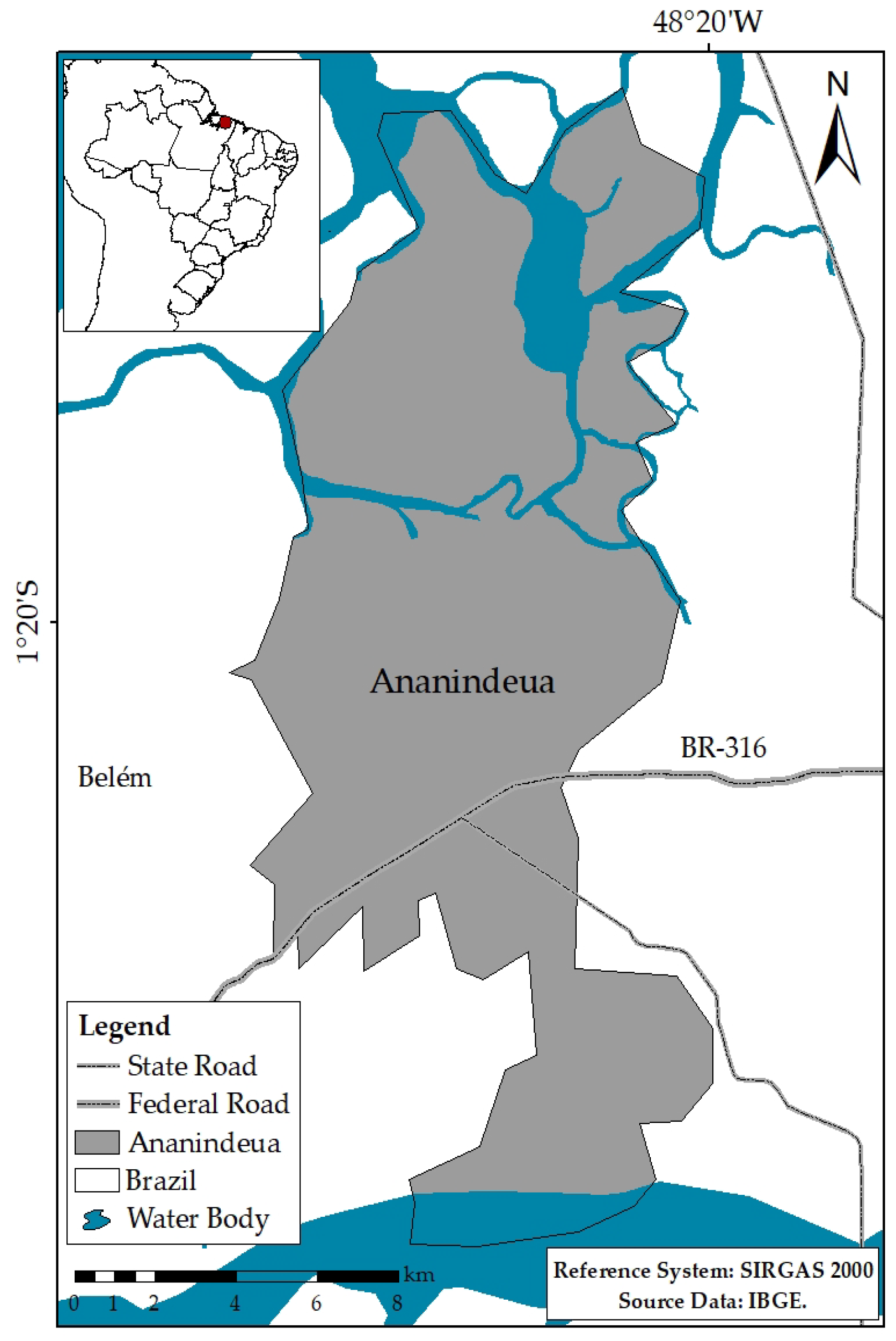
2.1. Study Area
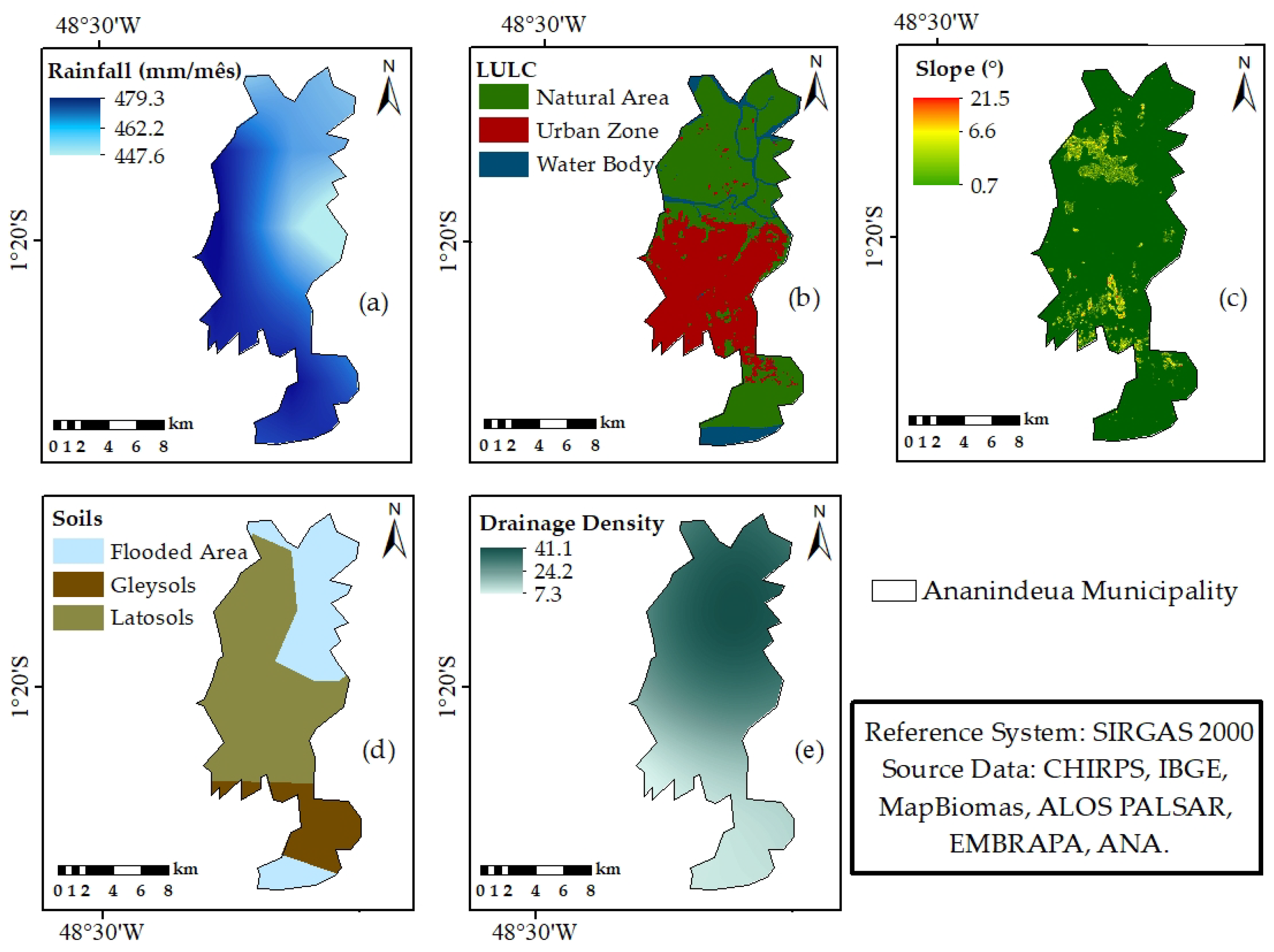
2.2. Selection and Justification of Criteria
2.3. Datasets and Data Sources
2.4. AHP and Susceptibility Calculation
2.4.1. Methodology Overview and Justification
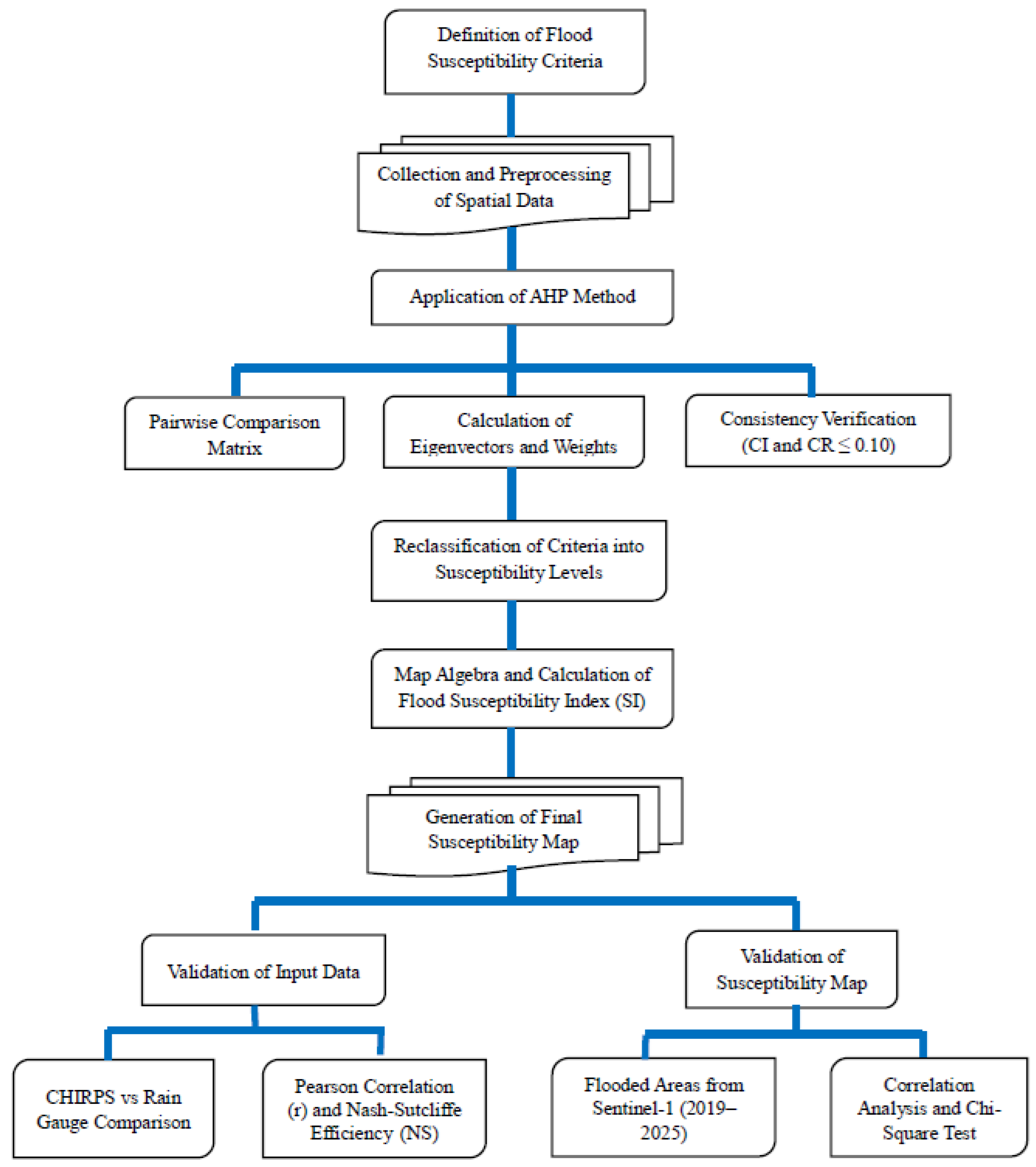
2.4.2. AHP Implementation Framework
2.4.3. Detailed Methodological Steps
- The relative importance among criteria was determined using a pairwise comparison scale (Table 4).
- A pairwise comparison matrix (PCM) was constructed, in which each element represented the relative importance of one criterion over another.
- The principal eigenvector of the PCM was calculated to derive the initial weights associated with each criterion.
- The weights were normalized by dividing each entry by its column sum and averaging the values across rows, ensuring the total equaled one.
- The consistency index (CI) was calculated using Equation (1):where λmax is the maximum eigenvalue and n is the number of criteria.CI = (λmax − n)/(n − 1)
- The consistency ratio (CR) was computed using Equation (2):where RI is the random index. A CR ≤ 0.10 indicated acceptable consistency in the judgments.CR = CI/RI
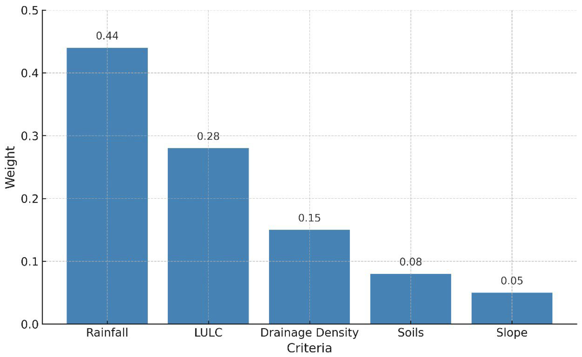
2.4.4. Weight Derivation and Validation
2.4.5. Criteria Classification and Susceptibility Levels
2.4.6. Final Map Generation
- SI = flood susceptibility index (dimensionless);
- p1 to p5 = normalized weights of each criterion;
- U, R, D, S, DD = reclassified values of land use/land cover, rainfall, slope, soil type, and drainage density, respectively.
2.5. Validation Procedures
3. Results and Discussions
3.1. Potential Susceptibility
3.2. Validation of the Flood Susceptibility Map
4. Conclusions
Author Contributions
Funding
Data Availability Statement
Acknowledgments
Conflicts of Interest
References
- Kumar, K.; Singh, D.P. Assessing the Dynamics of Urbanization: A Comprehensive Review of Associated Risks and Mitigation Strategies. J. Res. Infrastruct. Des. 2024, 6, 1–10. [Google Scholar] [CrossRef]
- Arif, M.; Sengupta, S.; Mohinuddin, S.K.; Gupta, K. Dynamics of land use and land cover change in peri urban area of Burdwan city, India: A remote sensing and GIS based approach. GeoJournal 2023, 88, 4189–4213. [Google Scholar] [CrossRef]
- Towner, J.; Ficchi, A.; Cloke, H.L.; Bazo, J.; Perez, E.C.; Stephens, E.M. Influence of ENSO and tropical Atlantic climate variability on flood characteristics in the Amazon basin. Hydrol. Earth Syst. Sci. 2021, 25, 3875–3895. [Google Scholar] [CrossRef]
- Xavier, D.R.; Barcellos, C.; Freitas, C.M. Eventos climáticos extremos e consequências sobre a saúde: O desastre de 2008 em Santa Catarina segundo diferentes fontes de informação. Ambient. Soc. 2014, 17, 273–294. [Google Scholar] [CrossRef]
- Goulart, L.P.; Matsuoka, J.V. Análise das Áreas Suscetíveis à Alagamentos E Inundações Na Área Urbana Do Município De Uberlândia—Mg Utilizando Geoprocessamento E O Método De Análise Hierárquica AHP. GETEC, v.10, n.34, p.21–44/2021. Available online: https://revistas.fucamp.edu.br/index.php/getec/article/view/2566 (accessed on 10 May 2024).
- Garcia, F.R.; Júnior, M.J.A. Comparação de MDTs a partir do acoplamento de modelo hidrológico e hidrodinâmico aplicado à identificação de áreas de inundações urbanas. Rev. Bras. De Geogr. Física 2022, 15, 783–803. [Google Scholar] [CrossRef]
- Agonafir, C.; Lakhankar, T.; Khanbilvardi, R.; Krakauer, N.; Radell, D.; Devineni, N. A review of recent advances in urban flood research. Water Secur. 2023, 19, 100141. [Google Scholar] [CrossRef]
- Gomes, D.J.C.; Nascimento, M.M.M.; Pereira, F.M.; Dias, G.F.M.; Meireles, R.R.; Souza, L.G.N.; Picanço, A.R.S.; Ribeiro, H.M.C. Flow variability in the Araguaia River Hydrographic Basin influenced by precipitation in extreme years and deforestation. Rev. Bras. De Ciências Ambient. 2022, 57, 451–466. [Google Scholar] [CrossRef]
- Gomes, D.J.C.; Beltrão, N.E.S. Impacts of ocean-atmosphere interaction phenomena on hydrometeorology of the Gurupi river watershed, Eastern Amazon. Rev. Bras. De Climatol. 2024, 34, 643–667. [Google Scholar] [CrossRef]
- Foley, J.A.; Botta, A.; Coe, M.T.; Costa, M.H. El Niño-Southern Oscillation and the climate, ecosystems and rivers of Amazonia. Glob. Biogeochem. Cycles 2002, 16, 1–17. [Google Scholar] [CrossRef]
- Ronchail, J.; Labat, D.; Callède, J.; Cochonneau, G.; Guyot, J.L.; Filizola, N.; Oliveira, E. Discharge Variability within the Amazon basin. Reg. Hydrol. Impacts Clim. Changes Hidroclimatic Var. 2005, 296, 21–30. Available online: https://iahs.info/uploads/dms/13191.07%2021-30%20Foz%20S6-2-22%20Ronchail.pdf (accessed on 10 May 2024).
- Coutinho, E.C.; Rocha, E.J.P.; Lima, A.M.M.; Ribeiro, H.M.C.; Gutierrez, L.A.C.L.; Barbosa, A.J.S.; Paes, G.K.A.A.; Bispo, C.J.C.; Tavares, P.A. Variabilidade climática da precipitação na bacia Amazônica brasileira entre 1982–2021. Rev. Bras. De Climatol. 2018, 22, 476–500. [Google Scholar] [CrossRef]
- Ministério do Meio Ambiente (MMA). Vulnerabilidade Ambiental/Rozely Ferreira dos Santos, Organizadora. 2007. Available online: https://fld.com.br/wp-content/uploads/2019/07/Vulnerabilidade_Ambiental_Desastres_Naturais_ou_Fenomenos_Induzidos.pdf (accessed on 14 May 2024).
- Zhang, J.X.; Cheng, J.W.; Philbin, S.P.; Ballesteros-Perez, P.; Skitmore, M.; Wang, G. Influencing factors of urban innovation and development: A grounded theory analysis. Environ. Dev. Sustain. 2023, 25, 2079–2104. [Google Scholar] [CrossRef]
- Andrade, M.M.N.; Bandeira, I.C.N.; Fonseca, D.D.F.; Bezerra, P.E.S.; Andrade, A.S.; Oliveira, R.S. Flood risk mapping in the Amazon. In: Theodore Hromadka and Prasada Rao. (Org.). Flood Risk Manag. 2017, 1, 41–54. [Google Scholar] [CrossRef][Green Version]
- Marengo, J.A.; Souza, C.M., Jr.; Thonicke, K.; Burton, C.; Halladay, K.; Betts, R.A.; Alves, L.M.; Soares, W.R. Changes in climate and land use over the Amazon region: Current and future variability and trends. Front. Earth Sci. 2018, 6, 1–21. [Google Scholar] [CrossRef]
- Portela, B.M.; Alves, G.B.; Silva, S.R.; Lafayette, K.P.V. Análise da vulnerabilidade à inundação na Bacia Hidrográfica do rio Sirinhaém, utilizando o Método de Análise Hierárquica. Rev. Bras. De Geogr. Física 2023, 16, 1247–1262. [Google Scholar] [CrossRef]
- Brito, A.J.; Conserva, C.S.; Araújo, C.B.; Lavinas, E.C.; Andrade, L.M.S. Expansão urbana e drenagem: Análise das soluções propostas para manejo de águas pluviais em região produtora de água na bacia do Paranoá, DF. Rev. Gestão Sustentabilidade Ambient. 2020, 9, 558. [Google Scholar] [CrossRef][Green Version]
- Li, T.; Chen, C.; Li, Q.; Liu, L.; Wang, Z. Evolution Characteristics of Landscape Patterns and the Response of Surface Runoff in a Rapid Urbanization Area: Focus on the Chang–Zhu–Tan Metropolitan Area of China. Water 2023, 15, 3467. [Google Scholar] [CrossRef]
- Eshghizadeh, M. Urban development scenarios on flood peak discharge in an arid urban watershed using the WinTR-55 hydrologic model. Int. J. Hum. Cap. Urban Manag. 2024, 9, 345–356. [Google Scholar] [CrossRef]
- Lu, X.H.; Faith, K.S.C.; Hing, K.C.; Chen, W.-Q. Mitigating flood impacts on road infrastructure and transportation by using multiple information sources. Resour. Conserv. Recycl. 2024, 206, 107607. [Google Scholar] [CrossRef]
- Ayenew, W.A.; Kebede, H.A. GIS and remote sensing based flood risk assessment and mapping: The case of Dikala watershed in Kobo Woreda Amhara region, Ethiopia. Environ. Sustain. Indic. 2023, 18, 2023. [Google Scholar] [CrossRef]
- Ghosh, A.; Chatterjee, U.; Pal, S.C.; Islam, A.R.M.T.; Alam, E.; Islam, M.K. Flood hazard mapping using GIS-based statistical model in vulnerable riparian regions of sub-tropical environment. Geocarto Int. 2023, 38, 1–18. [Google Scholar] [CrossRef]
- Miranda, F.; Franco, A.B.; Rezende, O.; Costa, B.B.F.; Najjar, M.; Haddad, A.N.; Miguez, M. A GIS-base index of physical susceptibility to flooding as a tool for flood risk management. Land 2023, 12, 1408. [Google Scholar] [CrossRef]
- Osman, S.A.; Das, J. GIS-based flood risk assessment using multi-criteria decision analysis of Shebelle river basin in Southern Somalia. SN Appl. Sci. 2023, 5, 1–17. [Google Scholar] [CrossRef]
- Trif, S.; Bilasco, S.; Petrea, D.; Rosca, S.; Fodorean, I.; Vescan, I. Spatial modelling through GIS analysis of flood risk and related financial vulnerability: Case study: Turco river, Romania. Appl. Sci. 2023, 13, 9869. [Google Scholar] [CrossRef]
- Li, Z.W.; Tang, X.G.; Li, L.; Chu, Y.; Wang, X.; Yang, D. GIS-based risk assessment of flood disaster in the Lijiang river basin. Sci. Rep. 2023, 13, 6160. [Google Scholar] [CrossRef]
- Akallouch, A.; Al Mashoudi, A.; Ziani, M.; Elhani, R. GIS application in urban flood risk analysis: Midar as a case study. Open J. Ecol. 2024, 14, 148–164. [Google Scholar] [CrossRef]
- Bullen, J.; Miles, A. Exploring local perspectives on flood risk: A participatory GIS approach for bridging the gap between modelled and perceived flood risk zones. Appl. Geogr. 2024, 163, 103176. [Google Scholar] [CrossRef]
- Efraimidou, E.; Spiliotis, M. A GIS-based flood risk assessment using the decision-making trial and evaluation laboratory approuach at a regional scale. Environ. Process. 2024, 11, 9. [Google Scholar] [CrossRef]
- Mukhtar, M.A.; Shangguan, D.; Ding, Y.; Anjum, M.N.; Banerjee, A.; Butt, A.Q.; Yadav, N.; Li, D.; Yang, Q.; Khan, A.A.; et al. Integrated flood risk assessment in Hunza-Nagar, Pakistan: Unifying big climate data analytics and multi-criteria decision-making with GIS. Front. Environ. Sci. 2024, 12, 1337081. [Google Scholar] [CrossRef]
- Ozkan, S.P.; Terhan, C. Detection of Flood Hazard in Urban Areas using GIS: Izmir Case. Procedia Technol. 2016, 22, 373–381. [Google Scholar] [CrossRef]
- Samela, C.; Albano, R.; Sole, A.; Manfreda, S. A GIS tool for cost-effective delineation of flood-prone areas. Comput. Environ. Urban Syst. 2018, 70, 43–52. [Google Scholar] [CrossRef]
- Silva, L.O.; Barbosa, K.V. Análise espacial da suscetibilidade à inundação na sub-bacia Muriaé 2, Campos dos Goytacazes (RJ). Rev. Ibero-Am. De Ciências Ambient. 2018, 9, 127–138. [Google Scholar] [CrossRef]
- Prama, M.; Omran, A.; Schroder, D.; Abouelmagd, A. Vulnerability assessment of flash floods in Wadi Dahab basin, Egypt. Environ. Earth Sci. 2020, 79, 1–17. [Google Scholar] [CrossRef]
- Mandel, L.H.; Bishop, B.W.; Orehek, A.M. A new decade of uses for geographic information systems (GIS) as a tool to research, measure and analyze library services. Libr. Hi Tech 2023, 41, 1022–1038. [Google Scholar] [CrossRef]
- Lima, A.C.C.; Faccioli, G.G.; Medeiros, F.C. Creation of a flood risk model for The Jacuípe River Basin (AL/PE) using the Analytical Hierarchical Process Method—AHP. Rev. De Gestão Soc. E Ambient. 2024, 18, 1–18. [Google Scholar] [CrossRef]
- Senouci, R.; Taibi, N.-E.; Teodoro, A.C.; Duarte, L.; Mansour, H.; Yahia Meddah, R. GIS-Based Expert Knowledge for Landslide Susceptibility Mapping (LSM): Case of Mostaganem Coast District, West of Algeria. Sustainability 2021, 13, 630. [Google Scholar] [CrossRef]
- Alarifi, S.S.; Abdelkareem, M.; Abdalla, F.; Alotaibi, M. Flash Flood Hazard Mapping Using Remote Sensing and GIS Techniques in Southwestern Saudi Arabia. Sustainability 2022, 14, 14145. [Google Scholar] [CrossRef]
- Zarghami, M.; Szidarovszky, F. Introduction to Multicriteria Decision Analysis. In Multicriteria Analysis; Springer: Berlin/Heidelberg, Germany, 2011. [Google Scholar] [CrossRef]
- Esmail, B.A.; Geneletti, D. Multi-criteria decision analysis for nature conservation: A review of 20 years of applications. Methods Ecol. Evol. 2018, 9, 42–53. [Google Scholar] [CrossRef]
- Zlaugotne, B.; Zihare, L.; Balode, L.; Kalnbalkite, A.; Khabdullin, A.; Blumberga, D. Multi-Criteria Decision Analysis Methods Comparison. Environ. Clim. Technol. 2020, 24, 454–471. [Google Scholar] [CrossRef]
- Gongora-Salazar, P.; Rocks, S.; Dphil, P.F.; Dphil, O.R.-A.; Tsiachristas, A. The Use of Multicriteria Decision Analysis to Support Decision Making in Healthcare: An Updated Systematic Literature Review. Value Health 2023, 26, 780–790. [Google Scholar] [CrossRef]
- Saaty, T.L. What is the Analytic Hierarchy Process? In Mathematical Models for Decision Support; Mitra, G., Greenberg, H.J., Lootsma, F.A., Rijkaert, M.J., Zimmermann, H.J., Eds.; NATO ASI Series; Springer: Berlin/Heidelberg, Germany, 1988; Volume 48. [Google Scholar] [CrossRef]
- Li, H.; Wang, Y.; Chen, W.; Li, H.; Tian, Y.; Chen, R. Adaptability Evaluation of Human Settlements in Chengdu Based on ArcGIS. Sustainability 2024, 16, 1989. [Google Scholar] [CrossRef]
- Kalisha, S.M.; Munthali, K.G. Multi-Factor GIS Modeling for Solid Waste Dumpsite Selection in Lilongwe, Malawi. Sustainability 2024, 16, 1202. [Google Scholar] [CrossRef]
- Fattoruso, G.; Toscano, D.; Venturo, A.; Scognamiglio, A.; Fabricino, M.; Di Francia, G. A Spatial Multicriteria Analysis for a Regional Assessment of Eligible Areas for Sustainable Agrivoltaic Systems in Italy. Sustainability 2024, 16, 911. [Google Scholar] [CrossRef]
- Swain, K.C.; Singha, C.; Nayak, L. Flood Susceptibility Mapping through the GIS-AHP Technique Using the Cloud. ISPRS Int. J. Geo Inf. 2020, 9, 720. [Google Scholar] [CrossRef]
- Nguyen, H.N.; Fukuda, H.; Nguyen, M.N. Assessment of the Susceptibility of Urban Flooding Using GIS with an Analytical Hierarchy Process in Hanoi, Vietnam. Sustainability 2024, 16, 3934. [Google Scholar] [CrossRef]
- Madzík, P.; Falát, L. State-of-the-art on analytic hierarchy process in the last 40 years: Literature review based on Latent Dirichlet Allocation topic modelling. PLoS ONE 2022, 17, e0268777. [Google Scholar] [CrossRef]
- Saaty, T.L. How to make a decision: The analytic hierarchy process. Eur. J. Oper. Res. 1990, 48, 9–26. [Google Scholar] [CrossRef]
- Robin, C.; Beck, C.; Armstrong, B.; Waite, T.D.; Rubin, G.J.; Oliver, I. Impact of flooding on health-related quality of life in England: Results from the National Study of Flooding and Health. Eur. J. Public Health 2020, 30, 942–948. [Google Scholar] [CrossRef]
- Santos, J.A.; Moreno, J.A.; Monteiro, J.B. Urban Flooding in Manaus, Northern Brazil: Extreme Events, Susceptibility, and Inequalities. In Urban Flooding in Brazil; Springer: Cham, Switzerland, 2023. [Google Scholar] [CrossRef]
- Pegado, R.S.; Blanco, C.J.C.; Roehrig, J.; Caroça, C.; Costa, F.S. Risco de Cheia e Vulnerabilidade: Uma Abordagem às Inundações Urbanas de Belém/Pará/ no Brasil. Territorium 2014, 21, 71–76. Available online: http://www.uc.pt/fluc/nicif/riscos/Territorium/numeros_publicados (accessed on 6 June 2025). [CrossRef]
- Teixeira, S.G.; Pacheco, A.A. Cartografia de Risco Geológico: Ananindeua, Pará. Fev-2023; Editor: SGB-CPRM. Available online: https://rigeo.cprm.gov.br/handle/doc/23504 (accessed on 6 June 2025).
- Campos, W.S.; Miranda, S.B.A.; Dias, G.F.M.; Costa, J.A. Uso da Ferramenta SIG Aplicado a Alagamentos: Estudo de Caso Na Cidade de Belém (PA). DELOS 2020, 13. Available online: https://ojs.revistadelos.com/ojs/index.php/delos/article/view/669 (accessed on 6 June 2025).
- Gutierrez, C.B.B.; Souza, E.B.; Gutierrez, D.M.G. Global/Regional Impacts on Present and Near-Future Climate Regimes in the Metropolitan Region of Belém, Eastern Amazon. Atmosphere 2022, 13, 1077. [Google Scholar] [CrossRef]
- Instituto Brasileiro de Geografia e Estatística (IBGE)—Cidades. Ananindeua. Available online: https://cidades.ibge.gov.br/brasil/pa/ananindeua/panorama (accessed on 14 May 2024).
- Secretaria Municipal de Planejamento (SEGEP). Anuário Belém. Tabela 21-Ranking dos 10 Maiores IDHM dos Municípios do Pará; 2020. Available online: https://anuario.belem.pa.gov.br/wp-content/uploads/2020/12/Tabela-21-Demografia.pdf (accessed on 16 April 2024).
- Companhia de Desenvolvimento Econômico do Pará (CODEC). Distritos Industriais do Estado do Pará. Available online: https://www.codec.pa.gov.br/publicacoes/distritosindustriais (accessed on 6 June 2023).
- Prefeitura Municipal de Ananindeua Geo (PMA-Geo). Ananindeua—Mapas. Available online: https://www.ananindeua.pa.gov.br/mapas/ (accessed on 6 September 2023).
- Weather Spark (WS). Clima e Condições Meteorológicas Médias em Ananindeua no ano Todo Brasil. Available online: https://pt.weatherspark.com/y/30138/Clima-caracter%C3%ADstico-em-Ananindeua-Brasil-durante-o-ano (accessed on 7 April 2023).
- Prefeitura Municipal de Ananindeua (PMA). O Município. Available online: https://cma.pa.gov.br/o-municipio/ (accessed on 7 April 2023).
- Ullah, N.; Tariq, A.; Qasim, S.; Panezai, S.; Uddin, M.G.; Abdullah-Al-Wadud, M.; Ullah, S. Geospatial analysis and AHP for flood risk mapping in Quetta, Pakistan: A tool for disaster management and mitigation. Appl Water Sci 2024, 14, 236. [Google Scholar] [CrossRef]
- Mohammed, Z.T.; Hussein, L.Y.; Abood, M.H. Potential Flood Hazard Mapping Based on GIS and Analytical Hierarchy Process. J. Water Manag. Model. 2014, 32, C528. [Google Scholar] [CrossRef]
- Ozturk, D.; Yilmaz, I.; Kirbas, U. Flood hazard assessment using AHP in Corum, Turkey. Tecnol. Y Cienc. Del Agua 2021, 12, 379–415. [Google Scholar] [CrossRef]
- Belazreg, N.E.H.; Hasbaia, M.; Sen, Z.; Ferhati, A. Flood risk mapping using multi-criteria analysis (MCA) through AHP method case of El-Ham wadi watershed of Hodna basin (Algeria). Nat. Hazards 2024, 120, 1023–1039. [Google Scholar] [CrossRef]
- Msabi, M.M.; Makonyo, M. Flood susceptibility mapping using GIS and multi-criteria decision analysis: A case of Dodoma region, central Tanzania. Remote Sens. Appl. Soc. Environ. 2021, 21, 100445. [Google Scholar] [CrossRef]
- Shekar, P.R.; Mathew, A. Chapter 7—Flood susceptibility mapping of the Peddavagu River Basin using GIS-AHP techniques. Dev. Environ. Sci. 2023, 14, 125–141. [Google Scholar] [CrossRef]
- Edamo, M.L.; Bushira, K.; Ukumo, T.Y. Flood susceptibility mapping in the Bilate catchment, Ethiopia. H2Open J. 2022, 5, 691–712. [Google Scholar] [CrossRef]
- Bokhari, B.F.; Bassam, T.; Baalousha, H.M. A analytical hierarchy process -GIS approach to flood susceptibility mapping in NEOM, Saudi Arabia. Front. Water 2024, 6, 1–14. [Google Scholar] [CrossRef]
- Sharir, K.; Lai, G.T.; Simon, N.; Ern, L.K.; Talip, M.A.; Roslee, R. Assessment of Flood Susceptibility Analysis Using Analytical Hierarchy Process (AHP) in Kota Belud Area, Sabah, Malaysia. IOP Conf. Ser. Earth Environ. Sci. 2022, 1103, 012005. [Google Scholar] [CrossRef]
- Khoeun, C.; Sok, T.; Chan, R.; Khe, S.; Ich, I.; Chan, K. Assessing Flood Hazard Index using Analytical Hierarchy Process (AHP) and Geographical Information System (GIS) in Stung Sen River Basin. IOP Conf. Ser. Earth Environ. Sci. 2022, 1091, 012031. [Google Scholar] [CrossRef]
- Seejata, K.; Yodying, A.; Wongthadam, T.; Mahavik, N.; Tantanee, S. Assessment of flood hazard areas using Analytical Hierarchy Process over the Lower Yom Basin, Sukhothai Province. Procedia Eng. 2018, 212, 340–347. [Google Scholar] [CrossRef]
- QGIS Development Team, (QGIS). Geographic Information System. Open source geospatial Foundation Project. 2015. Available online: http://qgis.osgeo.org (accessed on 1 June 2024).
- Funk, C.; Peterson, P.; Landsfeld, M.; Pedreros, D.; Verdin, J.; Shukla, S.; Husak, G.; Rowland, J.; Harrison, L.; Hoell, A.; et al. The climate hazards infrared precipitation with stations—A new environmental record for monitoring extremes. Sci. Data 2015, 2, 150066. [Google Scholar] [CrossRef]
- Hofstra, N.; Haylock, M.; New, M.; Jones, P.D. Testing E-OBS European high-resolution gridded data set of daily precipitation and surface temperature. J. Geophys. Res. 2009, 114, D21101. [Google Scholar] [CrossRef]
- Mantis, A.B.; Vaz, J.A. Mapeamento de áreas de risco de alagamento do município de Guarujá-SP utilizando método de análise hierárquica. Leopoldianum 2019, 45, 69–85. [Google Scholar] [CrossRef]
- Leal, F.C.B.S.; Barbosa, I.M.R.; Aquino, J.T. Mapeamento de áreas vulneráveis à inundação com o uso do SIG e da análise multicritério: O caso da bacia hidrográfica do rio UNA em Pernambuco. Rev. Gestão Sustentabilidade Ambient. 2020, 9, 20–40. [Google Scholar] [CrossRef]
- Kader, Z.; Islam, M.R.; Aziz, M.T.; Hossain, M.M.; Islam, M.R.; Miah, M.; Jaafar, W.Z.W. GIS and AHP-based flood susceptibility mapping: A case study of Bangladesh. Sustain. Water Resour. Manag. 2024, 10, 170. [Google Scholar] [CrossRef]
- Ashfaq, S.; Tufail, M.; Niaz, A.; Muhammad, S.; Alzahrani, H.; Tariq, A. Flood susceptibility assessment and mapping using GIS-based analytical hierarchy process and frequency ratio models. Glob. Planet. Change 2025, 251, 104831. [Google Scholar] [CrossRef]
- Pimenta, L.B.; Beltrão, N.E.S.; Oliveira, R.M.S.; Gomes, D.J.C. Multi-criteria Decision-Making methods to evaluate urban environmental quality: A scoping review. Concilium 2024, 24, 492–516. [Google Scholar] [CrossRef]
- Satty, T.L. A scaling method for priorities in hierarquical structures. J. Math. Psychol. 1977, 15, 234–281. [Google Scholar] [CrossRef]
- Magalhães, I.A.L.; Thiago, C.R.L.; Agrizzi, D.V.; Santos, A.R. Uso de Geotecnologias Para Mapeamento de Áreas de Risco de Inundação em Guaçui, ES: Uma Análise Comparativa Entre Dois Métodos. Cad. De Geociências 2011, 8, 63–70. Available online: https://periodicos.ufba.br/index.php/cadgeoc/article/view/5288 (accessed on 7 July 2024).
- Pereira, M.D.R.; Cristo, S.S.V. Análise da Susceptibilidade a Inundação na Bacia Hidrográfica do Córrego São João, Porto Nacional-TO. Rev. Interface. 2018, 16, pp. 82–96. Available online: https://sistemas.uft.edu.br/periodicos/index.php/interface/article/view/6523 (accessed on 6 May 2024).
- Dias, F.G.; Lima, A.M.M. Zoneamento hidroambiental da bacia hidrográfica do rio Acará, Amazônia Oriental. Cad. De Geogr. 2020, 30, 431–450. [Google Scholar] [CrossRef]
- Pimenta, L.B.; Beltrão, N.E.S.; Gemaque, A.M.S.; Tavares, P.A. Processo Analítico Hierárquico (AHP) em ambiente SIG: Temáticas e aplicações voltadas à tomada de decisão utilizando critérios espaciais. Interações 2019, 20, 407–420. [Google Scholar] [CrossRef]
- Castro, A.C.V.; Alvim, A.T.B. Sustainable Urbanization in Valley-Bottom Areas in Urban Settings: The Case of the Jaguaré Stream Basin, São Paulo, Brazil. Sustainability 2024, 16, 3018. [Google Scholar] [CrossRef]
- Lustosa, K.; Júnior, F.L.; Oliveira, H. The use of permeable asphalt for the benefit of drainage systems in urban areas - A literature review. ITEGAM-JETIA 2023, 9, 18–24. [Google Scholar] [CrossRef]
- Pezente, M.F.M. Relação entre urbanização e rios: Um Estudo da Cidade de Francisco Beltrão (PR). Repositório Institucional da UFSC. Dissertação. 2018. Available online: https://repositorio.ufsc.br/handle/123456789/198544 (accessed on 7 April 2025).
- Caroletti, G.N.; Coscarelli, R.; Caloiero, T. Validation of satellite, reanalysis and RCM data of Monthly rainfall in Calabria (Southern Italy). Remote Sens. 2019, 11, 1625. [Google Scholar] [CrossRef]
- Kim, S.; Lee, J.; Jeon, S.; Lee, M.; An, H.; Jung, K.; Kim, S.; Park, D. Correlation analysis between hydrologic flow metrics and Benthic Macroinvertebrates Index (BMI) in the Han River basin, South Korea. Sustainability 2021, 13, 11477. [Google Scholar] [CrossRef]
- Krakauer, N.Y.; Pradhanang, S.M.; Lakhankar, T.; Jha, A.K. Evaluating satellite products for precipitation estimation in mountain regions: A case study for Nepal. Remote Sens. 2013, 5, 4107–4123. [Google Scholar] [CrossRef]
- Lufi, S.; Ery, S.; Rispiningtati, R. Hydrological analysis of TRMM (Tropical Rainfall Measuring Mission) Data in Lesti Sub Watershed. Civ. Environ. Sci. J. 2020, 3, 18–30. [Google Scholar] [CrossRef]
- Lin, F.; Chen, X.; Yao, H. Evaluating the Use of Nash-Sutcliffe Efficiency Coefficient in Goodness-of-Fit Measures for Daily Runoff Simulation with SWAT. J. Hydrol. Eng. 2017, 22, 05017023. [Google Scholar] [CrossRef]
- Perreault, S.; Alem, A.E.; Chokmani, K.; Cambouris, A.N. Development to pedotransfer functions to predict soil physical properties in Southern Quebec (Canada). Agronomy 2022, 12, 526. [Google Scholar] [CrossRef]
- França, L.C.D.J.; Lopes, L.F.; Morais, M.S.D.; Lisboa, G.D.S.; Rocha, S.J.S.S.D.; Morais Junior, V.T.M.D.; Santana, R.C.; Mucida, D.P. Environmental Fragility Zoning Using GIS and AHP Modeling: Perspectives for the Conservation of Natural Ecosystems in Brazil. Conservation 2022, 2, 349–366. [Google Scholar] [CrossRef]
- Gomes, D.J.C.; Beltrão, N.E.S.; Lima, A.M.M. Influence of climatic phenomena and deforestation on hydroenvironmental fragility, Gurupi River watershed, Northern Brazil. Rev. Bras. De Ciências Ambient. 2023, 58, 375–385. [Google Scholar] [CrossRef]
- Moraes, R.B.F. Development of the Urban Hydrological Disasters Susceptibility Index. Doctorate Thesis, Universidade Federal de Mato Grosso do Sul, UFMS, Campo Grande, Brasil, 2023. Available online: https://repositorio.ufms.br/handle/123456789/6487 (accessed on 7 July 2025).
- Muttil, N.; Nasrin, T.; Sharma, A.K. Impacts of Extreme Rainfalls on Sewer Overflows and WSUD-Based Mitigation Strategies: A Review. Water 2023, 15, 429. [Google Scholar] [CrossRef]
- Leite, M.E.; Dias, F.T.; Almeida, J.W.L.; Santos-Neto, N.F. Land use and environmental impacts: Flood model in a medium-sized Brazilian city as a tool for urban sustainability. Environ. Sci. Policy 2024, 151, 103613. [Google Scholar] [CrossRef]
- Rözer, V.; Mehryar, S.; Surminski, S. From managing risk to increasing resilience: A review on the development of urban flood resilience, its assessment and the implications for decision making. Environ. Res. Lett. 2022, 17, 123006. [Google Scholar] [CrossRef]
- Waseem, M.; Ahmad, S.; Ahmad, I.; Wahab, H.; Leta, M.K. Urban flood risk assessment using AHP and geospatial techniques in Swat Pakisan. SN Appl. Sci. 2023, 5, 215. [Google Scholar] [CrossRef]
- Saaty, R.W. The analytic hierarchy process—What it is and how it is used. Math. Model. 1987, 9, 161–176. [Google Scholar] [CrossRef]

| Parameters | Criteria Number | Methods | Study Areas | References |
|---|---|---|---|---|
| TWI, elevation, slope, LULC, rainfall, stream distance, DD, and soil type. | 8 | AHP and GIS | Quetta city, Pakistan (urban) | [64] |
| TWI, NDVI, elevation, slope, LULC, rainfall, DD, distance from the road, and distance from river. | 9 | AHP, GIS, and Remote Sensing | Diyala city, Iraq (Urban) | [65] |
| Rainfall, distance to rivers, slope, elevation, LULC, rocks, and watershed size. | 7 | AHP and GIS | Corum city, Turkey (Urban) | [66] |
| Rainfall, DD, slope, elevation, LULC, and soil type. | 6 | AHP and GIS | El-Ham, Algeria (Watershed) | [67] |
| Rainfall, DD, flow accumulation, slope, elevation, LULC, rocks, and soil type. | 8 | AHP and GIS | Dodoma city, Tanzania (Urban) | [68] |
| TWI, elevation, slope, LULC, rainfall, distance to river, and DD. | 7 | AHP, GIS, and Remote Sensing | Peddavagu, India (Watershed) | [69] |
| LULC, TWI, STI, elevation, slope, rainfall, distance to river, and DD. | 8 | AHP and GIS | Bilate, Ethiopia (Watershed) | [70] |
| LULC, TWI, NDVI, elevation, slope, soil type, rainfall, distance to river, and DD. | 9 | FAHP and GIS | Neom, Saudi Arabia (Watershed) | [71] |
| DD, slope elevation, soil type, LULC, TWI. | 6 | AHP and GIS | Kota Belud city, Malaysia (Urban) | [72] |
| Slope, elevation, soil type, LULC flow accumulation, DD, and rainfall. | 7 | FHI, AHP and GIS | Stung Sen, Cambodia (Watershed) | [73] |
| Rainfall, slope, elevation, river density, LULC, and soil permeability. | 6 | AHP and GIS | Yom, Thailand(Watershed) | [74] |
| Criteria | Sources | SR | Year |
|---|---|---|---|
| Rainfall (mm) | Spatial distribution–Climate Hazards Group InfraRed Precipitation with Stations (CHIRPS) data set: https://www.chc.ucsb.edu/data/chirps (accessed on 14 May 2024) | 0.05° | 2022 |
| LULC | MapBiomas Project is available through Google Earth Engine from the website https://mapbiomas.org/ (accessed on 14 May 2024) | 30 m | 2023 |
| Slope | Alos Palsar (ASF): https://asf.alaska.edu/datasets/daac/alos-palsar/ (accessed on 14 May 2024) | 12.5 m | 2020 |
| Soils | Obtained from: https://geoinfo.dados.embrapa.br/catalogue/#/dataset/2350 (accessed on 14 May 2024) | 30 m | 2020 |
| Drainage Density (km.km−2) | Based on the delimitations of rivers acquired from Agência Nacional de Águas e Saneamento Básico (ANA) | 30 m | 2020 |
| Importance Relative | Degree of Importance | |
|---|---|---|
| Equal | 1 | |
| More | Few | 3 |
| Very | 5 | |
| Quite | 7 | |
| Extremely | 9 | |
| Less | Few | 1/3 |
| Very | 1/5 | |
| Quite | 1/7 | |
| Extremely | 1/9 |
| Rainfall (mm/month) | LULC | Slope(°) | Soils | Drainage Density (km.km−2) | Sum | Weights | |
|---|---|---|---|---|---|---|---|
| Rainfall (mm/month) | 1 | 5 | 3 | 3 | 0.33 | 19.00 | 0.44 |
| LULC | 0.2 | 1 | 5 | 5 | 0.2 | 14.20 | 0.28 |
| Slope (°) | 0.33 | 0.2 | 1 | 3 | 0.14 | 2.06 | 0.05 |
| Soils | 0.33 | 0.2 | 0.33 | 1 | 0.14 | 4.73 | 0.08 |
| Drainage Density (km.km−2) | 3 | 5 | 7 | 7 | 1 | 7.66 | 0.15 |
| Total | 4.86 | 11.4 | 16.33 | 19 | 1.81 | 47.65 | 1.00 |
| Class | Weights | Description |
|---|---|---|
| Low | 1 | Potential flood formation resistance |
| Medium | 2 | Moderate potential of some geoenvironmental variables that favor flood formation |
| High | 3 | Potential unstable areas extremely sensitive to the action of geoenvironmental factors that contribute to the flood |
| Low | Medium | High | |
|---|---|---|---|
| Rainfall (mm/month) | <170 | 171 > 250 | 251< |
| LULC | Natural area | - | Urban zone |
| Slope (°) | <8 | 8 > 17 | 17< |
| Soils | - | Gleisoil | Water, Latosoil |
| Drainage Density (km.km−2) | <10 | 10 > 20 | 20< |
| NS | Interpretation |
|---|---|
| ≤0 | Unacceptable |
| 0.0 ≤ 0.40 | Weak |
| 0.41 ≤ 0.60 | Moderate |
| 0.60 ≤ 0.80 | Good |
| 0.81 ≤ 1.0 | Excellent |
| Low | Medium | High | |
|---|---|---|---|
| Rainfall (mm/month) | 0 | 4.0 km2 | 184.8 km2 |
| LULC | 44.4 km2 | 0.1 km2 | 140.1 km2 |
| Soils | 0 | 105.1 km2 | 79.7 km2 |
| Slope (°) | 0 | 0.1 km2 | 184.7 km2 |
| Drainage Density (km.km−2) | 18.5 km2 | 55.3 km2 | 110.9 km2 |
Disclaimer/Publisher’s Note: The statements, opinions and data contained in all publications are solely those of the individual author(s) and contributor(s) and not of MDPI and/or the editor(s). MDPI and/or the editor(s) disclaim responsibility for any injury to people or property resulting from any ideas, methods, instructions or products referred to in the content. |
© 2025 by the authors. Licensee MDPI, Basel, Switzerland. This article is an open access article distributed under the terms and conditions of the Creative Commons Attribution (CC BY) license (https://creativecommons.org/licenses/by/4.0/).
Share and Cite
Pimenta, L.; Duarte, L.; Teodoro, A.C.; Beltrão, N.; Gomes, D.; Oliveira, R. GIS-Based Flood Susceptibility Mapping Using AHP in the Urban Amazon: A Case Study of Ananindeua, Brazil. Land 2025, 14, 1543. https://doi.org/10.3390/land14081543
Pimenta L, Duarte L, Teodoro AC, Beltrão N, Gomes D, Oliveira R. GIS-Based Flood Susceptibility Mapping Using AHP in the Urban Amazon: A Case Study of Ananindeua, Brazil. Land. 2025; 14(8):1543. https://doi.org/10.3390/land14081543
Chicago/Turabian StylePimenta, Lianne, Lia Duarte, Ana Cláudia Teodoro, Norma Beltrão, Dênis Gomes, and Renata Oliveira. 2025. "GIS-Based Flood Susceptibility Mapping Using AHP in the Urban Amazon: A Case Study of Ananindeua, Brazil" Land 14, no. 8: 1543. https://doi.org/10.3390/land14081543
APA StylePimenta, L., Duarte, L., Teodoro, A. C., Beltrão, N., Gomes, D., & Oliveira, R. (2025). GIS-Based Flood Susceptibility Mapping Using AHP in the Urban Amazon: A Case Study of Ananindeua, Brazil. Land, 14(8), 1543. https://doi.org/10.3390/land14081543


