Article

Spaceborne LiDAR Reveals Anthropogenic and Biophysical Drivers Shaping the Spatial Distribution of Forest Aboveground Biomass in Eastern Himalayas

1
Ecoresolve, San Francisco, CA 94105, USA
2
Mediterranean Forestry and Natural Resources Management, School of Agriculture, University of Lisbon, Tapada da Ajuda, 1349-017 Lisboa, Portugal
3
Department of Forestry and Biodiversity, Tripura University, Suryamaninagar, Tripura 799202, India
4
Scion, Christchurch 8011, New Zealand
5
Department of Agricultural and Forest Sciences and Engineering, University of Lleida, 25198 Lleida, Spain
6
Department of Forestry, Mizoram University, Aizawl 796004, India
*
Author to whom correspondence should be addressed.
Land 2025, 14(8), 1540; https://doi.org/10.3390/land14081540
Submission received: 25 June 2025 / Revised: 20 July 2025 / Accepted: 25 July 2025 / Published: 27 July 2025

Abstract

The distribution of forest aboveground biomass density (AGBD) is a key indicator of carbon stock and ecosystem health in the Eastern Himalayas, which represents a global biodiversity hotspot that sustains diverse forest types across an elevation gradient from lowland rainforests to alpine meadows and contributes to the livelihoods of more than 200 distinct indigenous communities. This study aimed to identify the key factors influencing forest AGBD across this region by analyzing the underlying biophysical and anthropogenic drivers through machine learning (random forest). We processed AGBD data from the Global Ecosystem Dynamics Investigation (GEDI) spaceborne LiDAR and applied filtering to retain 30,257 high-quality footprints across ten ecoregions. We then analyzed the relationship between AGBD and 17 climatic, topographic, soil, and anthropogenic variables using random forest regression models. The results revealed significant spatial variability in AGBD (149.6 ± 79.5 Mg ha−1) across the region. State-wise, Sikkim recorded the highest mean AGBD (218 Mg ha−1) and Manipur the lowest (102.8 Mg ha−1). Within individual ecoregions, the Himalayan subtropical pine forests exhibited the highest mean AGBD (245.5 Mg ha−1). Topographic factors, particularly elevation and latitude, were strong determinants of biomass distribution, with AGBD increasing up to elevations of 2000 m before declining. Protected areas (PAs) consistently showed higher AGBD than unprotected forests for all ecoregions, while proximity to urban and agricultural areas resulted in lower AGBD, pointing towards negative anthropogenic impacts. Our full model explained 41% of AGBD variance across the Eastern Himalayas, with better performance in individual ecoregions like the Northeast India-Myanmar pine forests (R2 = 0.59). While limited by the absence of regionally explicit stand-level forest structure data (age, stand density, species composition), our results provide valuable evidence for conservation policy development, including expansion of PAs, compensating avoided deforestation and modifications in shifting cultivation. Future research should integrate field measurements with remote sensing and use high-resolution LiDAR with locally derived allometric models to enhance biomass estimation and GEDI data validation.

1. Introduction

The tropical and subtropical forests of the Eastern Himalayas in northeast India are exceptionally diverse, spanning a range of vegetation types due to the region’s unique elevation gradient. From the moist deciduous forests in lowland areas of Tripura and Assam to the alpine forests at higher altitudes in northern Arunachal Pradesh and Sikkim, the region includes a rich variety of ecosystems [1,2]. These forests are part of two biodiversity hotspots (Indo-Burma and Himalayas), which are globally recognized for their high levels of species diversity and endemism [1]. For instance, among 8000 species of recorded flowering plants, 2526 species are found to be endemic [3]. The region contributes significantly to the overall forest cover and biodiversity of South Asia by providing crucial ecosystem services such as carbon sequestration, water regulation and soil stabilization. Conservation strategies in Eastern Himalayas blend formal protected areas (PAs) such as national parks, wildlife sanctuaries, and biosphere reserves, with traditional community forest management practices, including sacred groves and community-conserved forests.
This ecologically sensitive zone is also home to over 200 groups of indigenous people, many of whom depend on forest resources for their livelihood and cultural practices [2]. Traditional forest management practices such as conservation of clan forests and the protection of sacred groves have long played a role in sustainable resource use in the region [4,5]. However, these forests have been increasingly degraded due to deforestation, unsustainable levels of shifting cultivation (locally known as Jhum), and rapid population growth following the 1947 partition of India. Jhum is a traditional slash-and-burn shifting cultivation system practiced on hill slopes by clearing, burning, sowing, and rotating fields and typically growing upland rice, but also maize, pulses (soybeans, black gram, green gram, cowpea, lablab, etc.), vegetables (potatoes, pumpkins, cucumbers, eggplant, etc.), and spices (turmeric, ginger, etc.) [6]. Immigration-driven land conversion in states like Assam and Tripura over decades has significantly altered the region’s forest landscape, leading to fragmentation and subsequent urbanization [7,8]. Additionally, competition with other land uses, such as large-scale horticultural plantations (large cardamom in Sikkim; rubber and areca nut in Tripura; tea in Assam, Tripura, and North Bengal, and oil palm in almost every state), has led to forest fragmentation and biodiversity loss [9,10,11,12]. Mining activities, excessive grazing, forest fires, invasive species, hunting and overharvesting of forests have further exacerbated ecological stress [13,14]. These combined factors have placed immense pressure on the region’s ecosystems [2]. Between 2013 and 2023, northeast India lost 3132.3 km2 of forest cover, while its population grew from roughly 45.6 million to about 51.8 million, an increase of ~13.6%, highlighting significant land-use pressures [15,16].
Accurate quantification of forest biomass in this fragile and biodiverse region is critical for sustainable bioeconomy planning, carbon accounting, and achieving climate mitigation goals [17,18]. Identifying key determinants of forest productivity is necessary in the Eastern Himalayas, where diverse forest types exist across elevation and climatic gradients. Forest productivity (the rate at which a forest accumulates biomass over time) is shaped by a complex interplay of numerous biophysical factors, including both environmental conditions and stand-level characteristics. Stand-level factors like canopy height, stand density, and basal area are extensively studied, as these metrics provide a direct measure of forest productivity [19]. These attributes are critical for modeling forest biomass and understanding variations in productivity across different forest types. Stand density and age are key modulators of productivity in subtropical forests [20]. Similarly, the normalized stand height at a given age, known as site index, is a useful indicator of site productivity in even-aged stands [21]. Numerous studies have shown that all these stand-level descriptors of productivity, other than being shaped by forest management practices, are largely controlled by underlying biophysical factors like topography, soil properties, and climate [22,23].
Among the underlying biophysical factors, topography plays an important role in determining the climate and soil properties of a particular region, which in turn influences tree species distribution and forest composition [24]. Topography shapes local nutrient availability and hydrological conditions, creating a heterogeneous forest structure. Climatic conditions such as temperature and precipitation patterns, and photosynthetically active radiation (PAR), directly impact biomass accumulation and carbon sequestration [25,26]. Soil properties such as pH, bulk density, texture, and moisture also influence forest productivity by altering nutrient availability and root development [27]. Asner and Mascaro [28] highlighted the critical role of soil properties on tropical forest biodiversity and carbon storage. Human-induced activities such as deforestation, fragmentation, and agricultural encroachment further alter the natural dynamics of a forest ecosystem [29]. In particular, intensification of otherwise sustainable practices such as shifting cultivation in tropical Asia by drastically reducing the fallow cycle (<5 years) have caused increasingly similar effects to permanent land-use change from forests to agriculture. These practices have been linked to reduced forest biomass and subsequent increases in greenhouse emissions [30,31,32].
The proximity of forests to agricultural lands and built-up areas influences degradation patterns, while the presence or absence of legal protection affects long-term forest sustainability [33,34]. Although PAs generally exhibit higher biomass and lower carbon loss, they remain vulnerable to degradation due to external pressures, including socioeconomic conditions of the surrounding region and management challenges [35]. Forest management in the region is largely constrained by strict legal regulations on timber harvesting and a ban on clear-felling in state-managed reserved forests, and thus poses minimal anthropogenic disturbance compared to more direct drivers like illegal logging, deforestation, and land-use change [36,37]. However, large areas in the Eastern Himalayas also fall under community-managed forests and shifting cultivation landscapes, where tribal customary rights coexist under the Government of India’s Forest Rights Act, 2006.
The main research question guiding this study is: “What are the key biophysical and anthropogenic drivers that shape the spatial distribution of forest aboveground biomass across the Eastern Himalayas?” While some studies in northeast India have explored individual factors affecting forest biomass, these have largely focused on single variables or small local areas. For example, Ahirwal et al. [38] analyzed altitude and latitude as drivers in the Indian Himalayas. Sharma et al. [39] reported elevation–AGB relationships for Manipur, and Das et al. [40] examined biomass recovery in shifting cultivation fallows. Other studies, such as Tashi et al. [41], have linked soil pH with elevation, but did not extend these findings regionally. Similar integrated approaches have been tested internationally—for instance, regression models in Borneo, Côte d’Ivoire, and the Chinese Loess Plateau have demonstrated how combining biophysical and anthropogenic factors improves biomass estimates [42,43,44]. These insights remain fragmented for the Eastern Himalayas, and no study to date has combined both biophysical and anthropogenic drivers at the regional scale across multiple ecoregions. Moreover, traditional field-based studies in these environments face significant challenges, including dense vegetation, rugged terrain, and limited accessibility, making data collection expensive, labor-intensive, and time-consuming. These difficulties are further exacerbated by harsh weather conditions and the challenge of scaling local measurements to larger areas [45,46].
The integration of multispectral and synthetic aperture radar (SAR) imagery with machine learning algorithms has facilitated the development of highly accurate models for large-scale forest biomass estimation [45,47,48]. Machine learning algorithms can accommodate non-linear complex relationships between multiple variables, process large datasets efficiently, and handle mixed variable types and missing values [49,50]. These advantages are especially valuable for this study’s approach, which integrates diverse predictors across heterogeneous landscapes of the Eastern Himalayas. Data from multispectral, SAR, and light detection and ranging (LiDAR) sensors have shown strong correlations with field-measured biomass [48,51,52,53,54]. In particular, LiDAR data provide critical insights into vegetation structure, including canopy height, vertical distribution, and three-dimensional forest structure, which are key for quantifying aboveground biomass [55,56]. The NASA Global Ecosystem Dynamics Investigation (GEDI) mission has revolutionized biomass estimation by providing openly accessible spaceborne LiDAR data. Aboveground biomass density, i.e., the mass of all living vegetation above the soil, including trunks, branches, bark, leaves, and reproductive parts per unit area, usually expressed in oven-dry megagrams per hectare [57], can now be mapped in detail using GEDI Level 4A/B data for tropical and subtropical zones. This capability enables the expansion of LiDAR-based analysis to both regional and global scales [58,59]. GEDI has significantly enhanced large-scale forest monitoring and biomass estimation with a large number of sampled measurements spanning latitudes between 51.6° north and south [60].
The objective of this study is two-fold: (1) to model forest biomass as a function of climatic, topographic, edaphic, and anthropogenic factors by leveraging GEDI spaceborne LiDAR observations and machine learning, and (2) to assess the relative positive or negative influence of these factors on biomass variation across ten different ecoregions in the Eastern Himalayas. Drivers such as altitude, climate, soil properties, and topographic heterogeneity play a crucial role in shaping forest productivity, while anthropogenic pressures—including land-use changes to agriculture, deforestation, and resource extraction—further alter biomass distribution. Our study provides a comprehensive understanding of the relative importance of natural and human-induced influences on forest biomass dynamics in this vulnerable and biodiversity-rich region. The remainder of this paper is structured as follows: Section 2 describes the study area, data sources, and modeling framework; Section 3 presents the results; Section 4 discusses the implications with key insights and future directions; and Section 5 concludes with the main scientific contributions of this study.

2. Methods

2.1. Study Area

The Indian Eastern Himalayas are situated between a latitude of 22° and 29°30′ N and a longitude of 88° and 97°30′ E (Figure 1). This region covers approximately 275,000 km2 and accounts for 8.4% of India’s total land area. Our study area encompasses the northeastern part of India and comprises nine states: Sikkim, Assam, Arunachal Pradesh, Manipur, Meghalaya, Nagaland, Mizoram, Tripura, and five districts of northern West Bengal (Darjeeling, Kalimpong, Jalpaiguri, Cooch Bihar and Alipurduar). The region borders China, Nepal, Bhutan, Bangladesh, and Myanmar. The area is characterized by diverse climate, vegetation, and a unique elevation gradient spanning altitudes from near-sea level to 8000 m. The climate in this area is primarily monsoon-influenced humid subtropical (Cwa) with warm, moist summers and moderate winters [61]. The vegetation ranges from tropical evergreen forests in lower elevations to alpine meadows at higher altitudes along the tree line at around 4000–4500 m [62]. The region is renowned for its biodiversity richness, and is part of two global biodiversity hotspots [3,63]. The Indian Eastern Himalayas comprises ten ecoregions as defined by the Ecoregions 2017 dataset [64]. These ecoregions are: Brahmaputra valley semi-evergreen forests, Eastern Himalayan broadleaf forests, Eastern Himalayan subalpine conifer forests, Himalayan subtropical pine forests, Lower Gangetic plains moist deciduous forests, Meghalaya subtropical forests, Mizoram-Manipur-Kachin rainforests, Northeast Himalayan subalpine conifer forests, Northeast India-Myanmar pine forests, and Terai-Duar savanna and grasslands.

2.2. Data Collection

We obtained aboveground biomass density (AGBD) data from the GEDI Level 4A (L4A) dataset [60], which provides footprint-level predictions of AGBD in megagrams per hectare (Mg ha−1). The GEDI footprints (~25 m diameter) are spaced approximately 60 m along-track and 600 m cross-track and are located within the latitude band observed by the International Space Station (ISS), spanning 51.6 degrees north and south. This wide spatial coverage falls within the full range of ecoregions needed to test our research question across the Eastern Himalayas. AGBD footprints in GEDI L4A are derived from parametric ordinary least squares (OLS) models that relate simulated GEDI Level 2A (L2A) waveform relative height (RH) metrics to globally collected field plot AGBD estimates derived using allometric scaling equations. Specifically, for tropical forests in Asia, GEDI L4A used the Chave et al. [65] moist forest pantropical model Equation (1) to create field estimates of AGBD that were used for training the GEDI footprint-level AGBD models.
AGB tree = 0.0673   × ( ρ D 2 H ) 0.976
where AGBtree is the aboveground biomass per tree (Mg), ρ is wood specific gravity (g cm−3), D is diameter at breast height (cm), and H is tree height (m). The field plot AGB estimates were then summed and expressed per unit area to produce plot-level AGBD. These plot-level AGBD values were used to calibrate the GEDI footprint models by stratifying the OLS regressions by plant functional type (PFT), e.g., deciduous broadleaf (DBT), evergreen broadleaf (EBT), evergreen needleleaf (ENT), and world regions, so that model coefficients reflect structural differences among forest types [58,59]. For the Eastern Himalayas, the models used are given below as Equations (2)–(4). The calibration procedure involved training these models using quality-controlled simulated GEDI waveforms matched to the field plots, with geographically stratified cross-validation to ensure robust generalization across diverse forest types and regions.
AGBD DBT = 1.017   ×   ( - 110.059 + 5.134   ×   RH 60 + 100 + 6.172   ×   RH 98 + 100 ) 2  
AGBD EBT = 1.113   ×   ( - 104.965 + 6.802   ×   RH 50 + 100 + 3.955   ×   RH 98 + 100 ) 2
AGBD ENT = 1.018   ×   ( - 118.411 + 7.777   ×   RH 60 + 100 + 4.378   ×   RH 98 + 100 ) 2
where AGBD (Mg ha−1) is measured for each plant functional type and RHn refers to the relative height metric derived from GEDI Level 2A waveform data; for example, RH60 is the height below which 60% of the cumulative waveform energy is returned, relative to the ground. RH metrics characterize vertical canopy structure.
For this study, we retained the default calibration settings optimized for regional PFTs by initially processing 150,342 unfiltered GEDI footprints. The footprints, each a ~25 m diameter “sample” representing a laser shot’s vertical canopy structure, were then filtered via stratified random sampling by randomly selecting GEDI footprints within each state and proportionally reducing them so that sampling density matched the relative forest cover of that state [66,67]. A grid of 5 × 5 km2 sampling boxes was placed over each state using Google Earth Engine (GEE) for distributing GEDI footprints relative to forest cover. Sampling boxes are shown in red on our study area map (Figure 1).
The composite AGBD data of 2020–2024 was processed and filtered in GEE, where first the Google Dynamic World V1 composite map of 2020–2024 was used to mask the non-forest areas to retain only those pixels where trees were the most likely class (i.e., where the probability of a pixel being classified as trees is maximum). Then, we applied quality masks to select the best GEDI shots to ensure reliable AGBD estimates. These masks, including degradation flags, slope flags, and Landsat tree cover flags from 2010 (the earliest available global dataset) ensured that sampled stands were at least 10 years old [68]. To make sure that the stands being sampled were at least 10–15 years of age and to confirm the absence of disturbances over the past 15 years, we used the MODIS Burnt Area data to mask out footprints that were subject to fire between 2010–2024, as the trends of shifting cultivation are prominent in the region. Monoculture tree plantations (e.g., rubber) were excluded to sample only natural forests. This filtering process yielded 30,257 high-quality footprints for analysis, ensuring that the footprints reflect undisturbed mature forests, thereby improving model reliability (see Supplementary Table S1 for threshold values for data filtering). To formally check whether mean AGBD differed significantly across states and ecoregions, we conducted one-way and two-way ANOVA tests. Moreover, to mitigate spatial autocorrelation inherent in ecological data, the stratified random sampling design by state removed ~80% of the original GEDI footprints to minimize clustering effects and reduce sampling bias. A Moran’s I test confirmed a substantial reduction in spatial autocorrelation (from 0.47 to 0.32, p < 0.001) after filtering.
We used the Ecoregions 2017 dataset [64] to assign the collected AGBD footprints to 10 different ecoregions within the Eastern Himalayas. We then assembled 14 biophysical and 3 anthropogenic variables in GEE for each filtered footprint to analyze their effects on AGBD distribution across each ecoregion. These variables included topographic, edaphic, climatic, and anthropogenic factors, comprising 2 categorical and 15 continuous variables. Examples include elevation, slope, and aspect from the NASADEM [69]; height above nearest drainage (HAND) [70]; median 5-day precipitation and precipitation range (1984–2024) [71]; median daily land surface temperature and temperature range (2004–2024) [72]; photosynthetically active radiation (PAR) [73]; distances to agricultural and urban areas [74]; PA status [75]; and soil attributes such as moisture content [76], pH [77], bulk density [78], and texture class [79] (see Supplementary Table S2).

2.3. Model Development and Validation

We used the random forest regression model to estimate the contribution of each underlying factor towards the spatial distribution of AGBD through the ‘randomForest’ package in R programming language. Random forest is an ensemble algorithm based on decision trees that is applicable for both regression and classification tasks [80] and is robust against overfitting data, as opposed to single decision trees, because of data randomness and through weighting the average of outputs. Their ensemble, nonparametric nature provides advantages over traditional parametric regression, including the ability to learn from limited training data, handle complex nonlinear relationships and interactions more readily, and manage mixed variable types efficiently [49,50], while being computationally efficient and easier to tune for our large and diverse dataset.
We split the dataset into a 70:30 ratio with 70% (20,180 footprints, ~25 m diameter) being used for model training and 30% (9077 footprints, ~25 m diameter) for testing. The models were developed using the training dataset and their accuracy was validated using the testing dataset. Prior to model development, we conducted a feature selection process to address multicollinearity among continuous variables. We computed a correlation matrix and applied a threshold of ±0.9 to identify highly correlated pairs. For each pair exceeding this threshold, we retained the variable with greater importance, as determined by preliminary model assessments, and excluded the other less important variable [81,82]. Median temperature, which had a strong negative correlation (−0.96) with elevation, was removed from the full model (EH). Similarly, within individual ecoregions (E01–E10), correlated variables were identified and removed based on their relationships with other predictors. Supplementary Figures S1–S11 provide correlation matrices for each model.
We performed a five-fold cross-validation procedure to optimize performance during model training and fine-tuned two hyperparameters: number of decision trees in the model (ntree) and variables per splitting node of a decision tree (mtry) from a predefined grid and identified the set with the least error as the optimal configuration for model training [48,83]. For computational efficiency, we limited the maximum ntree to be roughly 10% of the rows of the training dataset and set the maximum possible mtry to the total number of independent variables (see Supplementary Table S3). We evaluated model performance using regression metrics such as the coefficient of determination (R2), root mean square error (RMSE), and relative RMSE (%) for both regional and ecoregion-level scales [48]. Additionally, we used variable importance and partial dependence plots to assess the influence of each independent variable on AGBD variation.

3. Results

3.1. Descriptive Statistics and Data Preprocessing
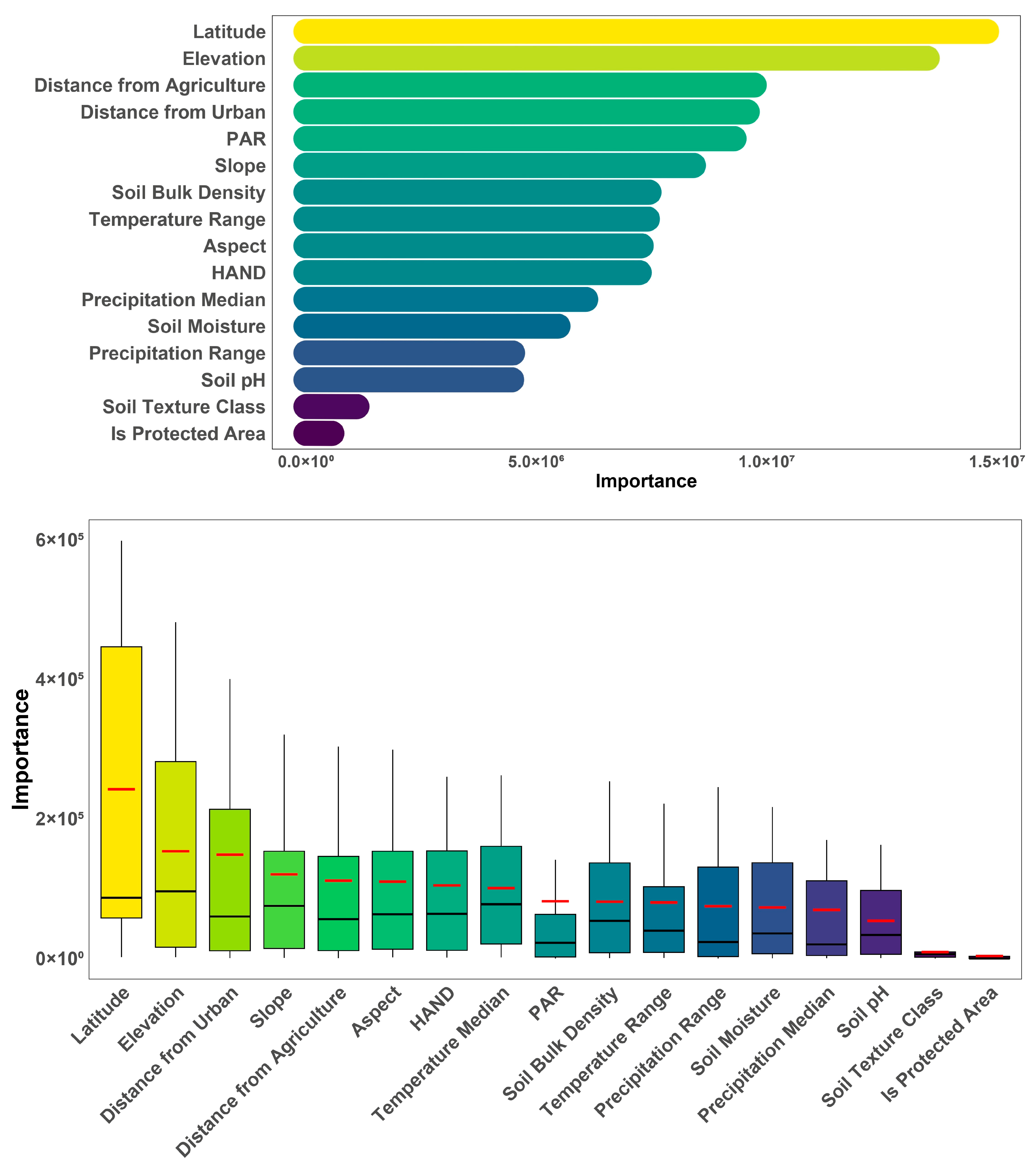
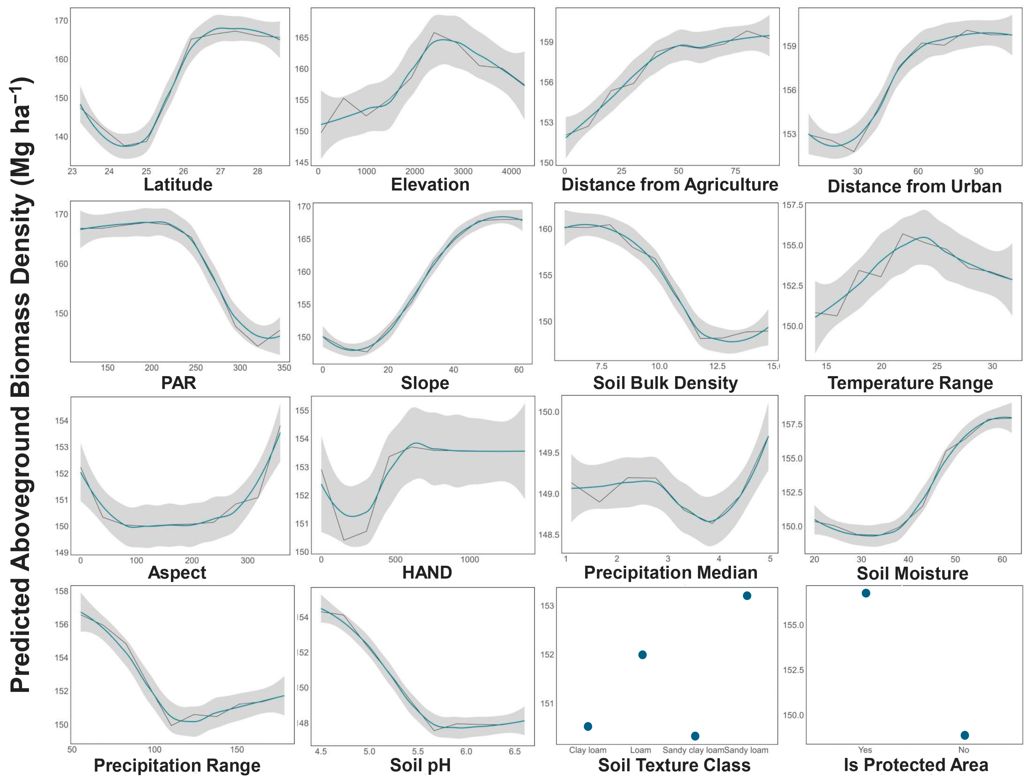
The descriptive statistics for AGBD revealed significant spatial variability across both states and ecoregions in the Eastern Himalayas (Figure 2). Among the states, Sikkim recorded the highest mean AGBD (218 Mg ha−1), whereas Manipur had the lowest mean (102.8 Mg ha−1). Arunachal Pradesh and Nagaland also exhibited relatively high AGBD, with mean AGBD exceeding 190 Mg ha−1 in both states. In contrast, Tripura, Mizoram, and northern West Bengal had lower mean AGBD values (Table 1).
Concerning the ecoregions, the Himalayan subtropical pine forests (E04) recorded the highest mean AGBD (245.5 Mg ha−1), followed by the Eastern Himalayan broadleaf forests (E02) with a mean of 219.3 Mg ha−1. The lowest AGBD values were observed in the Terai-Duar savanna and grasslands (E10), with a mean of 111.7 Mg ha−1, and in the Mizoram-Manipur-Kachin rainforests (E07), where the mean AGBD was 128.3 Mg ha−1 (Table 2). All of the sampled protected areas of the region showed a higher AGBD than the median of their respective ecoregions (see Supplementary Table S4). Among the sampled protected areas, the Dehing Patkai National Park in Assam had the highest median AGBD at 204.9 Mg ha−1.
The descriptive statistics of continuous variables collected across each sample observation in Eastern Himalayas highlight that elevation ranged from 53 to 4268 m, with a mean of 1068.1 ± 919.7 m. Median daily land surface temperature varied from 1.6 °C to 27.5 °C (mean 20.5 ± 5.3 °C). Distance from urban and agricultural areas showed wide ranges, with means of 42.4 ± 22.5 km and 22.8 ± 25.8 km, respectively. Soil properties like pH (4.5–6.6) showed that the soil was acidic, and bulk density (5.9–14.7 kg m−3) reflected diverse soil conditions. Most soils were classified as clay loam (65.3%), followed by loam (30.9%). Around 12.9% of the GEDI footprints were collected from within PAs (Table 3, Table 4). For statistics within each ecoregion, see Supplementary Tables S5a–S14b. The one-way ANOVA tests revealed significant differences in mean AGBD across both states (F = 824.2, p < 0.001) and ecoregions (F = 444.9, p < 0.001), and a two-way ANOVA further confirmed a significant interaction effect between State and Ecoregion (F = 82.4, p < 0.001) (Supplementary Tables S15–S17, Supplementary Figure S32).
Within each ecoregion, we found several variable pairs to be highly correlated. For instance, we found that latitude was highly correlated with distance from anthropogenic activities in the northern parts of the region, particularly in Sikkim, northern West Bengal, and northern Arunachal Pradesh. This pattern was especially evident in the Eastern Himalayan subalpine conifer forests (E03), the Himalayan subtropical pine forests (E04), and the Northeast Himalayan subalpine conifer forests (E08). In the Lower Gangetic plains moist deciduous forests of Assam and Tripura (E05), latitude was negatively correlated with both PAR and median temperature, while PAR exhibited a negative correlation with precipitation range. In the Mizoram-Manipur-Kachin rainforests (E07), latitude was negatively correlated with PAR, and median temperature showed a strong negative correlation with elevation. Within individual ecoregions, latitude was removed from E04, E05, and E08, while median temperature was removed from E04, E05, and E07. PAR and precipitation range were excluded from E05, and PAR was also removed from E07.

3.2. Model Results

The random forest regression model for the entire Eastern Himalayas (EH) demonstrated stronger performance compared to most individual ecoregions, with a test data R2 of 0.41, an RMSE of 60.15 Mg ha−1, and a percentage RMSE (40.29%) relative to all models developed in this study. The model was moderately effective in explaining the variability in AGBD across the region. In comparison, ecoregion-specific models showed varying performance. The E09 model (Northeast India-Myanmar pine forests) had the highest R2 of 0.59, while the E10 model (Terai-Duar savanna and grasslands) had the lowest RMSE (27.27 Mg ha−1) and percentage RMSE (24.44%). Moreover, cross-validation and test metrics were similar, indicating minimal overfitting or inflated model performance. Table 5 provides further details for each model.
The variable importance plot (Figure 3) summarizes and ranks the importance of variables fitted to the full model for Eastern Himalayas (above), while the weighted average importance plot (below) indicates the significance of each variable across individual ecoregion models. Latitude and elevation are consistently the most important variables, which indicates the dominance of geography in predicting AGBD across ecoregions. Similarly, anthropogenic variables including distance from urban and agricultural areas greatly affect biomass distribution in the region. Climatic variables such as median temperature and factors related to hydrology and topography such as HAND, slope, and aspect also have an important role in the spatial distribution of biomass across ecoregions. In the full model fit across the Eastern Himalayas, latitude and elevation remain the top contributors. Here too, anthropogenic variables including distance from agriculture and urban areas exhibit notable importance.
The partial dependence plots (PDPs) in Figure 4 provide insights into the intricate interplay of biophysical and anthropogenic factors in shaping forest biomass in the region. Elevation exhibits a nonlinear trend, with AGBD initially increasing at mid-altitudes before sharply declining at higher elevations. The partial response for latitude demonstrates higher AGBD in northern areas, such as Arunachal Pradesh and Sikkim Himalayas. Other factors such as distance from agriculture and urban areas also show clear trends, with biomass increasing and stabilizing with increasing distance from these areas. PAs consistently show higher biomass compared to unprotected areas. Climatic factors such as precipitation range indicate that regions with consistent rainfall rather than erratic patterns support higher biomass. Soil properties such as moisture and pH also significantly influence biomass, with higher soil moisture and acidic pH ranges supporting greater AGBD. Slope, HAND (height above nearest drainage), and aspect further highlight the importance of topography and hydrological conditions in determining biomass distribution.
Overall, our results highlight considerable spatial variability in AGBD across states and ecoregions driven by a combination of topographic, climatic, and anthropogenic factors. The models show that geographic variables such as latitude and elevation, along with proximity to land use such as agriculture and urban settlements, are the strongest predictors of biomass distribution. PAs consistently exhibited higher AGBD than unprotected forests.

4. Discussion

This study set out to answer the question: What are the key biophysical and anthropogenic drivers that shape the spatial distribution of forest aboveground biomass across the Eastern Himalayas? Our main objective was to model forest biomass as a function of both natural and human-induced factors by leveraging GEDI spaceborne LiDAR observations and machine learning, and to assess the relative influence of these drivers across ten different ecoregions. The Eastern Himalayas is a fragile mosaic of numerous forest ecosystems ranging from tropical evergreen forests at lower elevations to temperate broadleaf and coniferous forests at mid-elevations, and alpine meadows at higher altitudes [84]. The region contributes some of the highest forest cover percentages (43%) in south Asia [85], and includes two global biodiversity hotspots, while sustaining a population of over 50 million people representing more than 200 distinct indigenous tribes, along with their diverse cultures and traditional practices. Our findings examined the spatial variability of AGBD in this region and highlight the main drivers and management implications.
The overall mean AGBD for the Eastern Himalayas was found to be 149.6 ± 79.5 Mg ha−1, which is comparable with the estimates reported for northeast India by Bordoloi et al. [86]. The wide ranges and high standard deviations from mean AGBD suggest the presence of both high-biomass forests and areas with relatively low biomass, likely influenced by differences in land use, forest types, and environmental conditions. The descriptive statistics revealed significant differences across both states and ecoregions. This is supported by formal one-way and two-way ANOVA tests, which confirmed significant differences and a significant State × Ecoregion interaction effect (Supplementary Tables S15–S17). Trends in AGBD for each state-wise ecoregion combination are shown in Supplementary Figure S32. Among the states, Sikkim recorded the highest mean AGBD, whereas Manipur had the lowest. This high biomass density can be attributed to Sikkim’s location, where the dominance of tall coniferous and evergreen broadleaved species (Castanopsis hystrix, Castanopsis tribuloides, Quercus lamellosa) contributes to significant carbon storage with basal area being ~40–45 m2 ha−1 in high-elevation (>1700 m asl) stands [87,88]. Arunachal Pradesh and Nagaland also exhibited relatively high AGBD. The high AGBD in these states may be attributed to the prevalence of diverse forest types (tropical wet evergreen forest, tropical semi-evergreen forest, and tropical moist deciduous forest) and relatively low population densities, especially in Arunachal Pradesh where the state-wide average is under 17 people per km2, with remote districts such as Dibang Valley and Upper Siang recording as few as 4–5 people per km2 [9,89,90]. Additionally, strict traditional customary laws and clan-based regulations have played a significant role in conserving these forests [91]. On the other hand, the lower AGBD in Manipur could be related to the dominance of shifting cultivation with shorter fallow periods (3–5 years) and land-use changes in these areas [38]. A longer fallow period in the jhum cycle (20+ years) can provide adequate time for natural restoration of the site [31,32,92,93].
Ecoregion-wise, the Himalayan subtropical pine forests (E04) recorded the highest mean AGBD at 245.52 Mg ha−1, followed by the Eastern Himalayan broadleaf forests (E02) with a mean of 219.33 Mg ha−1. The lowest AGBD values were observed in the Terai-Duar savanna and grasslands (E10), Lower Gangetic plains moist deciduous forests (E05), and the Mizoram-Manipur-Kachin rainforests (E07). The higher AGBD in the Himalayan forests can be attributed to the prevalence of mature, intact forests with greater aboveground biomass [94]. The high biomass can also be linked to low population density, lower prevalence of jhum cultivation, and human disturbance, which allow forests to remain relatively undisturbed [95,96]. The lower values in the Terai and Mizoram-Manipur-Kachin regions can be linked to the dominance of degraded and fragmented forests. The low biomass in the Terai region aligns with expectations, as savanna and grassland ecosystems naturally have lower forest cover, eventually contributing to lower tree biomass compared to densely forested regions [97].
Topography is one of the most important factors affecting the spatial distribution of AGBD [98]. Our study showed that geographic factors had a positive effect on aboveground biomass, of which latitude and altitude were the most influential. Latitude was positively correlated with distance from agriculture and negatively correlated with temperature (Supplementary Figure S1), suggesting that its effect on AGBD is likely mediated by both climatic and anthropogenic factors, which influence plant photosynthesis and respiration [99,100]. Ahirwal et al. [38] also reported increasing AGBD of trees with increasing latitude and altitude in the Indian Himalayan region. We also found that AGBD was relatively low up to 25° N latitude, primarily due to the high human population density and easy accessibility in these plain and lowland areas. Human activities such as deforestation, land conversion and infrastructure expansion have significantly disturbed the forests in low-altitude regions, leading to reduced forest biomass [38,101,102]. Above 25° N, where the terrain becomes more undulating and difficult to access, population density decreases, resulting in fewer anthropogenic disturbances and higher biomass [103]. We also observed that AGBD increased up to an elevation of approximately 2000 m above mean sea level, after which it began to decrease. The shift in vegetation types along the elevation gradient, from dense subtropical and temperate forests to alpine shrubs along the tree line (Juniperus indica, Rhododendron thomsonii, etc.), can contribute to this decrease [104]. This trend is primarily driven by climatic factors, as cooler temperatures at higher elevations shorten the growing season and limit photosynthesis. Moreover, colder temperatures and frost events at elevations above 2000 m inhibit plant growth, while soil quality declines due to thinner soils and lower nutrient availability [105]. Our results also align with Sharma et al. [39], who reported a positive relationship between elevation and AGB in Manipur, with elevation explaining 54% of the variance in AGB (R2 = 0.54), and biomass accumulation peaking at around 1500 m. Similarly, Cheng et al. [106] reported a hump-shaped AGBD trend in northwestern Yunnan, where biomass peaks at mid-elevations due to favorable conditions before decreasing at higher altitudes. Our findings confirm that altitude plays a dual role: enhancing biomass accumulation at mid-altitudes due to optimal climatic conditions while limiting growth at higher altitudes.
Additionally, we observed that steeper slopes in all ecoregions except E01 and E10 tend to support higher AGBD, likely due to reduced human disturbances [107]. Aspect also played a significant role in shaping biomass distribution, with south-, southwest-, west-, and northwest-facing slopes receiving a greater amount of sunlight, leading to increased rates of photosynthesis and greater vegetation productivity, particularly in higher elevation and latitudes of north Bengal, Arunachal Pradesh, and Sikkim (E01, E02, E03, E04, E08, E10; Supplementary Figures S22–S31) [106,108]. The topographical height above nearest drainage (HAND) indicates the importance of hydrology and water availability in biomass accumulation, especially in low-lying areas (E01, E02, E05, E06, E07, E08, E09; Supplementary Figures S22–S31).
Our variable importance plots also showed that proximity factors, particularly distance from urban and agricultural areas, also played a crucial role in determining biomass density. This is similar to the findings of KC et al. [94], who reported a negative impact of road features on AGBD in Terai region of Nepal. The urban heat island (UHI) effect, air pollution, and altered precipitation patterns near cities suppress vegetation growth and biomass accumulation [109]. Urbanization leads to deforestation, habitat fragmentation, and soil degradation, which leads to lower biomass accumulation near developed areas [110]. In contrast, forests farther from cities experience fewer disturbances, better soil conditions, and stable microclimates [111]. Proximity to agricultural lands often leads to deforestation, soil degradation, and edge effects, all of which suppress biomass accumulation [112,113]. Intensive farming depletes soil nutrients, whereas undisturbed forests further from agriculture retain better soil quality [114]. Human disturbances such as logging and grazing are more prevalent near agricultural zones, further reducing biomass [115,116]. Additionally, microclimatic stability in remote forests promotes enhanced tree growth and biomass productivity [117]. Jhum remains a significant driver of biomass variation, particularly in Mizoram, Nagaland, Arunachal Pradesh, and Tripura. Our findings indicate that biomass accumulation in areas proximal to both sedentary agriculture and jhum fallows remains substantially lower than in undisturbed forests, consistent with Das et al. [40], who found that older jhum fallows (>5 years) stored significantly more biomass than younger fallows (<5 years), yet remained well below the levels of dense forests. Similarly, Gogoi et al. [118] observed that AGBD in older jhum fallows (20–25 years) remained below that of old-growth forests. Our results further support the decline of shifting cultivation in Sikkim, where it is being replaced by more permanent land uses such as large cardamom agroforestry and Alnus nepalensis plantations, while it still remains prevalent in Nagaland, Arunachal Pradesh, and Manipur [119,120].
Our result showing that PAs exhibit higher than the median AGBD of their respective ecoregions further supports the effect of anthropogenic disturbance in the Eastern Himalayas. This aligns with previous studies [121,122,123,124], which reported that PAs store up to 3.6 times more biomass than disturbed forests. PAs are shielded from anthropogenic activities that degrade forests and reduce biomass accumulation [125]. In contrast, unprotected areas are more vulnerable to human interference, leading to deforestation, habitat fragmentation, and reduced biomass. Forests in PAs can undergo natural regeneration, resulting in higher tree density and biomass accumulation [126]. In the Eastern Himalayas and northeast India, forest management operates under a combination of governance regimes, including formally designated PAs, state-managed reserved forests, and extensive community-managed forests under customary tenure systems [123,127,128]. Large tracts of forest, particularly in states like Meghalaya, Manipur, and Arunachal Pradesh, are conserved through decentralized community institutions that maintain sacred groves, clan forests, and village reserved forests, and enforce community rules to limit extraction and maintain biodiversity [128]. These traditional systems coexist with reserved forests and PAs, though conflicts can arise when formal policies do not fully recognize customary rights [127]. In this context, the significance of states was also tested as an additional predictor of forest governance during preliminary modeling. ANOVA results confirmed that differences in AGBD across states were statistically significant (Supplementary Tables S15 and S17). However, despite having a statistical significance, its relative importance was much lower compared to direct biophysical and human-induced factors, and was dropped from the final models.
Temperature and precipitation had a moderate influence on biomass distribution. While precipitation variables were included in the model, their lower importance suggests that rainfall may have an indirect effect or be less influential in the Eastern Himalayas compared to other environmental factors. Optimal temperature and precipitation conditions are essential for AGB accumulation, as their effects vary depending on other interacting factors such as soil characteristics, nutrient availability, disturbance regimes, and species composition [94]. Precipitation range data indicated that areas with higher rainfall throughout the year supported greater AGB, a pattern also observed in relation to higher soil water content [129]. These findings underscore the role of water availability in supporting plant productivity and biomass accumulation. Similarly, the partial response function for temperature shows a range of no more than 16–20 °C between maximum and minimum temperatures to be optimal for higher biomass accumulation. A decreasing trend in AGBD with increasing PAR was also observed, as PAR was negatively correlated with latitude, while AGBD increased with latitude in the Eastern Himalayas (Supplementary Figure S1). PAR is a robust measure of primary productivity, as it influences tree physiology and sap flow [25]. However, the decrease of PAR with increasing AGBD in our study suggests a masking effect of anthropogenic and other effects on AGBD over PAR, as seen by the variable importance plot (Figure 3). Nevertheless, within individual ecoregions, we witnessed an increase in AGBD with increasing PAR (E03, E06, E10, Supplementary Figures S22–S31).
Soil properties also emerged as important determinants of AGBD in the Eastern Himalayas. A decrease in AGBD with increasing soil bulk density was found. Higher soil bulk density typically indicates compacted soils, which can hinder root penetration and reduce water drainage and nutrient uptake [130]. Compacted soils also negatively affect soil fertility by reducing microbial activity, which is essential for nutrient cycling and organic matter decomposition [131]. We also found that among the different soil texture classes, sandy loam soils exhibited the highest AGBD. This is because sandy loam soils usually have a good balance of sand, silt, and clay, which provides good drainage while retaining sufficient moisture, facilitating optimal root development and oxygen exchange [132]. Furthermore, sandy loam soils support efficient nutrient uptake and microbial activity, both of which contribute to increased biomass accumulation [133]. These findings align with Choudhury et al. [134], who found that finer-textured soils enhance biomass accumulation through improved moisture retention. Similarly, de Castilho et al. [135] reported a positive correlation between biomass and clay-rich soils. Our findings confirm that soil pH had a limited influence on biomass distribution. The increase in AGBD with decreasing soil pH at higher elevations in the region is consistent with these findings, as soil pH tends to decline with increasing altitude in the Eastern Himalayas [41]. Within individual ecoregions, maximum biomass accumulation was found within a pH range of 5–5.5 (Supplementary Figures S22–S31).
While remote sensing provides extensive spatial coverage, it may introduce uncertainties due to sensor limitations, cloud cover, and indirect biomass measurements. GEDI data has known limitations, as its model fit data were not available for India, which can introduce bias in AGBD estimates, and has been shown to overestimate biomass data for evergreen broadleaf trees (EBT) in Asia [58]. Additionally, forests with high horizontal heterogeneity and vertical complexity, such as mature forests in the Eastern Himalayas, tend to have increased AGBD errors, with similar research reporting relative RMSE ranging from 19% to 50% and canopy heterogeneity alone explaining over 30% of the error variance [136]. Furthermore, our full regression model for the Eastern Himalayas explained only 41% of the variance in AGBD (Table 5). This relatively modest explanatory power is consistent with the complex, multifactorial nature of biomass distribution in mountainous regions. It is important to emphasize that the primary goal of this study was not to maximize predictive accuracy by adding stand-structure variables such as canopy area, site index, or stand height, which would naturally increase model predictive capacity for biomass [137,138,139], but to interpret how key biophysical and anthropogenic factors influence stand-level conditions, which in turn shape the spatial patterns of forest biomass across the Eastern Himalayas. This outcome was expected, given that important stand-level drivers such as stand age, stand density, species composition, or wood density were not available as regionally explicit datasets. Undisturbed frontier forests of the northern Himalayan region are usually expected to have a higher stand age, which could aid them in accumulating higher biomass. Biodiversity indices also help in increasing model accuracy and explain the spatial distribution of biomass more effectively [48]. However, due to limited availability of data, such as the coarse spatial resolution of the IUCN species richness dataset, this was not possible to explore in this study.
Despite these limitations, our study provides valuable insights into the key factors influencing AGBD and highlights the importance of biophysical and anthropogenic variables. These findings contribute to the growing body of research on biomass estimation and can support efforts in carbon sequestration modeling, conservation planning, and sustainable land management. The findings support strategic expansion of PAs (national parks, wildlife sanctuaries, and biosphere reserves), development of buffer zones around high-biomass and high-conservation-value forests (HCVFs), and implementation of sustainable shifting cultivation practices with long fallow periods. Our study recommends five actions in the Eastern Himalayas: (1) district-level carbon auditing and monitoring with LiDAR-based and high resolution sensors; (2) strategic protected area expansion prioritizing high-biomass corridors vulnerable to encroachment to maintain genetic flow; (3) formal recognition of community conserved areas as carbon sanctuaries under India’s National REDD+ strategy with co-benefits shared with the local stakeholders; (4) district-specific shifting cultivation calendars calibrated to biomass recovery thresholds, with higher rotational cycles and nitrogen-fixing understory; and (5) proper compensation of forest fringe communities for avoided deforestation via verified carbon credits. Future land-use planning should adopt our AGBD-driven zoning framework to balance carbon, biodiversity, and livelihood goals. Future research should focus on integrating field measurements with remote sensing data to improve model calibration and validation. Additionally, incorporating high-density point cloud UAV-LiDAR could provide more accurate structural information on vegetation and tree height, leading to better biomass estimates. This could also serve as an avenue to validate and rectify the AGBD values generated from the GEDI spaceborne LiDAR. Since the GEDI L4A AGBD models for Eastern Himalayas have been trained on field data estimated using pantropical allometric models such as that of Chave et al. [65], field-based studies using locally derived allometric biomass models for the Eastern Himalayan regions can also be used to validate the GEDI data, as they have been seen to outperform pantropical models in the past [140,141]. Given the uncertainties of GEDI L4A for this region, the biomass estimates presented here should be considered preliminary, and their direct use for carbon or CO2 accounting under the UNFCCC or any other framework should be undertaken with due diligence.
The random forest regression model was used in our study, as it is robust against overfitting data compared to single decision trees by introducing data randomness and averaging outputs from multiple decision trees [48,142]. Other regression-based algorithms such as gradient boost methods (extreme gradient boosting, light gradient boosting) and convolutional neural networks (CNNs) often have high performance and should be tested in this context [38,143]. Given the overarching impact of anthropogenic disturbance found in our study, exploring the impact of climate change, disturbance events, and land-use policies on AGBD and biodiversity dynamics would be valuable for long-term biomass monitoring and conservation planning in the Eastern Himalayas. Furthermore, expanding our research framework across different tropical forest ecosystems would help in validating our findings.

5. Conclusions

AGBD across the Eastern Himalayas shows distinct spatial variability shaped by topography, land use, and disturbance regimes as the major underlying drivers contributing to this variability. Regions with less-disturbed forests, such as Sikkim and Arunachal Pradesh, exhibit higher AGBD compared to regions with extensive anthropogenic impact such as Manipur, Tripura, and North Bengal. Ecoregions dominated by mature, old-growth subalpine broadleaf and conifer forests support significantly higher AGBD compared to savannas and moist deciduous forests. Topographic factors, particularly elevation and latitude, play a crucial role in biomass distribution. AGBD increased with elevation up to 2000 m before declining due to climatic constraints and vegetation shifts. Steeper slopes and the south-western aspects positively influenced biomass accumulations. Proximity to urban and agricultural areas negatively impacts AGBD, reinforcing the value of protected areas, which were seen to consistently maintain higher biomass levels than their unprotected counterparts. While climatic factors such as precipitation and soil moisture availability influence AGBD, their impact appears to be secondary to land use and disturbance regimes. Our results underscore the importance of conservation strategies, particularly in mitigating the effects of deforestation, unsustainable levels of shifting cultivation, and urban expansion on biomass storage in the Eastern Himalayas. They also provide an important baseline for regional carbon accounting under India’s climate commitments.

Supplementary Materials

The following supporting information can be downloaded at: https://www.mdpi.com/article/10.3390/land14081540/s1, Table S1. Filters and masks applied on the composite AGBD data collected from GEDI; Table S2: Biophysical and anthropogenic factors tested for their impact on spatial distribution of AGBD in the Eastern Himalayas; Table S3. Tested hyperparameters in random forest regression for each ecoregion; Table S4. Descriptive statistics of the AGBD as recorded from the sampled protected areas; Table S5a–S14b. Descriptive statistics of the continuous and categorical variables as recorded from individual ecoregions (E01–E10); Table S15–S17. One-way and two-way ANOVA results; Figure S1–S11. Correlation matrix between aboveground biomass density and continuous independent variables in the Eastern Himalayas; Figure S12–S21. Variable importance plot for individual ecoregions (E01–E10); Figure S22–S31. Partial dependence plot for individual ecoregions (E01–E10); Figure S32. Trends in AGBD for each state-wise ecoregion in the Eastern Himalayas.

Author Contributions

Conceptualization, A.D.R. and M.M.; methodology, A.D.R., M.S.W., and M.M.; validation, S.D. and U.K.S.; formal analysis, A.D.R.; investigation, A.D.R.; data curation, A.D.R., A.R., S.T. and S.K.D.; writing—original draft preparation, A.D.R., A.R., S.T. and S.K.D.; writing—review and editing, A.D.R., A.R., M.S.W., S.d.-M., S.D., U.K.S. and M.M.; supervision, S.D. and U.K.S.; project administration, A.D.R. and M.M. All authors have read and agreed to the published version of the manuscript.

Funding

This research received no external funding.

Informed Consent Statement

During the preparation of this work the authors used the GPT model (v 3.5) strictly in order to improve the level of clarity and grammar in the text. After using this tool, the authors reviewed and edited the content as needed, and take full responsibility for the content of the publication.

Data Availability Statement

The data used in this study are derived from publicly available remote sensing datasets. Detailed information on data sources is provided in the Supplementary Materials.

Acknowledgments

We are thankful for the contributions of Sagnik Modak (SDE) and Abhijit Roy Choudhury (Department of Applied Mechanics, IIT Delhi) for providing insightful comments during the model development phase. We are also immensely grateful for the contributions of the anonymous reviewers during the peer review process.

Conflicts of Interest

Author Abhilash Dutta Roy was employed by the company Ecoresolve. And author Michael S. Watt was employed by the company Scion. The remaining authors declare that the research was conducted in the absence of any commercial or financial relationships that could be construed as a potential conflict of interest.

References

  1. Ao, A.; Changkija, S.; Tripathi, S.K. Stand Structure, Community Composition and Tree Species Diversity of Sub-Tropical Forest of Nagaland, Northeast India. Trop. Ecol. 2021, 62, 549–562. [Google Scholar] [CrossRef]
  2. Gogoi, B.; Lahon, D. Impact of Climate Change on Biodiversity of Northeast India: An Overview. Indian J. Appl. Pure Biol. 2022, 37, 322–331. [Google Scholar]
  3. Jain, A.; Das, A. North-East India: A Unique Biodiversity Paradise Unexplored or Lost? Int. J. Sci. Res. Publ. IJSRP 2022, 12, 112. [Google Scholar] [CrossRef]
  4. Laskar, B.I. The Sacred Groves of Meghalaya. In Environmental Intimacies from India’s North East; Routledge: New Delhi, India, 2024; ISBN 978-1-003-50487-0. [Google Scholar]
  5. Tiwari, B.K.; Tynsong, H.; Lynser, M.B. Forest Management Practices of the Tribal People of Meghalaya, North-East India. J. Trop. For. Sci. 2010, 22, 329–342. [Google Scholar]
  6. Wangpan, T.; Tangjang, S. Significance of Mixed-Cropping in Jhum Based Traditional Agroforestry in Tirap and Longding District of Arunachal Pradesh, India. J. Bioresour. Bioprod. 2015, 2, 62–73. [Google Scholar]
  7. Fernandes, W. Land, Environmental Degradation and Conflicts in Northeastern India. In Agriculture and a Changing Environment in Northeastern India; Routledge: New Delhi, India, 2020; pp. 119–134. [Google Scholar]
  8. Semy, K.; Singh, M.R. Changes in Plant Diversity and Community Attributes of Coal Mine Affected Forest in Relation to a Community Reserve Forest of Nagaland, Northeast India. Trop. Ecol. 2024, 65, 16–25. [Google Scholar] [CrossRef]
  9. Dikshit, K.R.; Dikshit, J.K. Agriculture in North-East India: Past and Present. In North-East India: Land, People and Economy; Advances in Asian Human-Environmental Research; Springer: Dordrecht, The Netherlands, 2014; pp. 587–637. ISBN 978-94-007-7054-6. [Google Scholar]
  10. Nad, C.; Roy, R.; Roy, T.B. Human Elephant Conflict in Changing Land-Use Land-Cover Scenario in and Adjoining Region of Buxa Tiger Reserve, India. Environ. Chall. 2022, 7, 100384. [Google Scholar] [CrossRef]
  11. Parida, B.R.; Mahato, T.; Ghosh, S. Monitoring Tea Plantations during 1990–2022 Using Multi-Temporal Satellite Data in Assam (India). Trop. Ecol. 2024, 65, 387–398. [Google Scholar] [CrossRef]
  12. Pasha, S.V.; Dadhwal, V.K.; Reddy, C.S. Rubber Expansion and Age-Class Mapping in the State of Tripura (India) 1990–2021 Using Multi-Year and Multi-Sensor Data. Environ. Monit. Assess. 2023, 195, 348. [Google Scholar] [CrossRef]
  13. Lotha, T.N.; Ritse, V.; Nakro, V.; Rudithongru, L.; Hazarika, N.; Jamir, L. Climate Change Impact and Traditional Adaptation Practices in Northeast India: A Review. Curr. World Environ. 2024, 19, 558–575. [Google Scholar] [CrossRef]
  14. Rai, P.K.; Singh, J.S. Plant Invasion in Protected Areas, the Indian Himalayan Region, and the North East India: Progress and Prospects. Proc. Indian Natl. Sci. Acad. 2021, 87, 19–35. [Google Scholar] [CrossRef]
  15. FSI India State of Forest Report 2023; Ministry of Environment, Forest and Climate Change, Government of India: New Delhi, India, 2023.
  16. NEDFi NE—General Information|NER DATABANK. Available online: https://databank.nedfi.com/node/105 (accessed on 13 July 2025).
  17. Adhikari, D.; Singh, P.P.; Tiwary, R.; Barik, S.K. Forest Carbon Stock-Based Bioeconomy: Mixed Models Improve Accuracy of Tree Biomass Estimates. Biomass Bioenergy 2024, 183, 107142. [Google Scholar] [CrossRef]
  18. Yanai, R.D.; Wayson, C.; Lee, D.; Espejo, A.B.; Campbell, J.L.; Green, M.B.; Zukswert, J.M.; Yoffe, S.B.; Aukema, J.E.; Lister, A.J. Improving Uncertainty in Forest Carbon Accounting for REDD+ Mitigation Efforts. Environ. Res. Lett. 2020, 15, 124002. [Google Scholar] [CrossRef]
  19. Zhang, Z.; Cao, L.; She, G. Estimating Forest Structural Parameters Using Canopy Metrics Derived from Airborne LiDAR Data in Subtropical Forests. Remote Sens. 2017, 9, 940. [Google Scholar] [CrossRef]
  20. Ouyang, S.; Xiang, W.; Wang, X.; Xiao, W.; Chen, L.; Li, S.; Sun, H.; Deng, X.; Forrester, D.I.; Zeng, L.; et al. Effects of Stand Age, Richness and Density on Productivity in Subtropical Forests in China. J. Ecol. 2019, 107, 2266–2277. [Google Scholar] [CrossRef]
  21. Zou, K.; Duan, G.; Wu, Y.; Wang, Z.; Liu, X. Site Index Model for Southern Subtropical Masson Pine Forests Using Stand Dominant Height. Forests 2023, 15, 87. [Google Scholar] [CrossRef]
  22. Wang, Z.; Zhang, X.; Chhin, S.; Zhang, J.; Duan, A. Disentangling the Effects of Stand and Climatic Variables on Forest Productivity of Chinese Fir Plantations in Subtropical China Using a Random Forest Algorithm. Agric. For. Meteorol. 2021, 304–305, 108412. [Google Scholar] [CrossRef]
  23. Zhang, J.; Li, M.; Cheng, R.; Ge, Z.; Liu, C.; Zhang, Z. Stand Structure and Functional Traits Determine Productivity of Larix Principis-Rupprechtii Forests. Forests 2024, 15, 924. [Google Scholar] [CrossRef]
  24. Jucker, T.; Bongalov, B.; Burslem, D.F.R.P.; Nilus, R.; Dalponte, M.; Lewis, S.L.; Phillips, O.L.; Qie, L.; Coomes, D.A. Topography Shapes the Structure, Composition and Function of Tropical Forest Landscapes. Ecol. Lett. 2018, 21, 989–1000. [Google Scholar] [CrossRef]
  25. Huang, J.; Haider, F.U.; Huang, W.; Liu, S.; Mwangi, B.N.; Suba, V.; Sikuku, L.; Tang, X.; Zhang, Q.; Chu, G. Influence of Photosynthetic Active Radiation on Sap Flow Dynamics across Forest Succession Stages in Dinghushan Subtropical Forest Ecosystem. Heliyon 2024, 10, e37530. [Google Scholar] [CrossRef] [PubMed]
  26. Kanniah, K.D.; Beringer, J.; North, P.; Hutley, L. Control of Atmospheric Particles on Diffuse Radiation and Terrestrial Plant Productivity: A Review. Prog. Phys. Geogr. Earth Environ. 2012, 36, 209–237. [Google Scholar] [CrossRef]
  27. Quesada, C.A.; Lloyd, J.; Anderson, L.O.; Fyllas, N.M.; Schwarz, M.; Czimczik, C.I. Soils of Amazonia with Particular Reference to the RAINFOR Sites. Biogeosciences 2011, 8, 1415–1440. [Google Scholar] [CrossRef]
  28. Asner, G.P.; Mascaro, J. Mapping Tropical Forest Carbon: Calibrating Plot Estimates to a Simple LiDAR Metric. Remote Sens. Environ. 2014, 140, 614–624. [Google Scholar] [CrossRef]
  29. Fahrig, L. Effects of Habitat Fragmentation on Biodiversity. Annu. Rev. Ecol. Evol. Syst. 2003, 34, 487–515. [Google Scholar] [CrossRef]
  30. AIPP; IWGIA. Drivers of Deforestation? Facts to Be Considered Regarding the Impact of Shifting Cultivation in Asia; AIPP: Chiang Mai, Thailand, 2012. [Google Scholar]
  31. Bruun, T.B.; Hepp, C.M. Carbon Footprint of Shifting Cultivation Landscapes: Current Knowledge, Assumptions and Data Gaps. Carbon Footpr. 2023, 2, 11. [Google Scholar] [CrossRef]
  32. Mukul, S.A.; Herbohn, J.; Firn, J. Tropical Secondary Forests Regenerating after Shifting Cultivation in the Philippines Uplands Are Important Carbon Sinks. Sci. Rep. 2016, 6, 22483. [Google Scholar] [CrossRef]
  33. Batar, A.; Watanabe, T.; Kumar, A. Assessment of Land-Use/Land-Cover Change and Forest Fragmentation in the Garhwal Himalayan Region of India. Environments 2017, 4, 34. [Google Scholar] [CrossRef]
  34. Graham, V.; Geldmann, J.; Adams, V.M.; Negret, P.J.; Sinovas, P.; Chang, H.-C. Southeast Asian Protected Areas Are Effective in Conserving Forest Cover and Forest Carbon Stocks Compared to Unprotected Areas. Sci. Rep. 2021, 11, 23760. [Google Scholar] [CrossRef]
  35. Collins, M.B.; Mitchard, E.T.A. A Small Subset of Protected Areas Are a Highly Significant Source of Carbon Emissions. Sci. Rep. 2017, 7, 41902. [Google Scholar] [CrossRef]
  36. Banerjee, A.K. Asia-Pacific Forestry Sector Outlook Study. In Decentralization and Devolution of Forest Management in Asia and the Pacific; Working Paper No.: APFSOS/WP/21; RAP: Saitama, Japan, 1997. [Google Scholar]
  37. Lainé, N. Effects of the 1996 Timber Ban in Northeast India: The Case of the Khamtis of Lohit District, Arunachal Pradesh. Nat. Environ. Soc. Conserv. Gov. Transform. India 2012, 73–93, xvii–xxiii. [Google Scholar]
  38. Ahirwal, J.; Nath, A.; Brahma, B.; Deb, S.; Sahoo, U.K.; Nath, A.J. Patterns and Driving Factors of Biomass Carbon and Soil Organic Carbon Stock in the Indian Himalayan Region. Sci. Total Environ. 2021, 770, 145292. [Google Scholar] [CrossRef]
  39. Sharma, K.; Saikia, A.; Goswami, S.; Borthakur, M. Aboveground Biomass Estimation and Carbon Stock Assessment along a Topographical Gradient in the Forests of Manipur, Northeast India. Arab. J. Geosci. 2020, 13, 443. [Google Scholar] [CrossRef]
  40. Das, B.; Bordoloi, R.; Deka, S.; Paul, A.; Pandey, P.K.; Singha, L.B.; Tripathi, O.P.; Mishra, B.P.; Mishra, M. Above Ground Biomass Carbon Assessment Using Field, Satellite Data and Model Based Integrated Approach to Predict the Carbon Sequestration Potential of Major Land Use Sector of Arunachal Himalaya, India. Carbon Manag. 2021, 12, 201–214. [Google Scholar] [CrossRef]
  41. Tashi, S.; Singh, B.; Keitel, C.; Adams, M. Soil Carbon and Nitrogen Stocks in Forests along an Altitudinal Gradient in the Eastern Himalayas and a Meta-analysis of Global Data. Glob. Change Biol. 2016, 22, 2255–2268. [Google Scholar] [CrossRef]
  42. Traoré, S.; Zo-Bi, I.C.; Piponiot, C.; Aussenac, R.; Hérault, B. Fragmentation Is the Main Driver of Residual Forest Aboveground Biomass in West African Low Forest-High Deforestation Landscapes. Trees For. People 2024, 15, 100477. [Google Scholar] [CrossRef]
  43. Van Der Laan, C.; Verweij, P.A.; Quiñones, M.J.; Faaij, A.P. Analysis of Biophysical and Anthropogenic Variables and Their Relation to the Regional Spatial Variation of Aboveground Biomass Illustrated for North and East Kalimantan, Borneo. Carbon Balance Manag. 2014, 9, 8. [Google Scholar] [CrossRef] [PubMed]
  44. Zhou, X.; Yamaguchi, Y. Relative Importance of Climatic and Anthropogenic Drivers on the Dynamics of Aboveground Biomass across Agro-Ecological Zones on the Mongolian Plateau. Sustainability 2018, 10, 3435. [Google Scholar] [CrossRef]
  45. Li, Y.; Li, M.; Li, C.; Liu, Z. Forest Aboveground Biomass Estimation Using Landsat 8 and Sentinel-1A Data with Machine Learning Algorithms. Sci. Rep. 2020, 10, 9952. [Google Scholar] [CrossRef]
  46. Shen, W.; Li, M.; Huang, C.; Wei, A. Quantifying Live Aboveground Biomass and Forest Disturbance of Mountainous Natural and Plantation Forests in Northern Guangdong, China, Based on Multi-Temporal Landsat, PALSAR and Field Plot Data. Remote Sens. 2016, 8, 595. [Google Scholar] [CrossRef]
  47. Pham, T.D.; Yoshino, K.; Bui, D.T. Biomass Estimation of Sonneratia Caseolaris (L.) Engler at a Coastal Area of Hai Phong City (Vietnam) Using ALOS-2 PALSAR Imagery and GIS-Based Multi-Layer Perceptron Neural Networks. GISci. Remote Sens. 2017, 54, 329–353. [Google Scholar] [CrossRef]
  48. Ranglong, A.; Dutta Roy, A.; Das, S.; Deb, S. Estimating Aboveground Biomass and Biodiversity of a Protected Area in Moist Tropical Forest Ecosystem Using Remote Sensing Application. J. Nat. Conserv. 2025, 84, 126823. [Google Scholar] [CrossRef]
  49. Liu, Z.; Peng, C.; Work, T.; Candau, J.-N.; DesRochers, A.; Kneeshaw, D. Application of Machine-Learning Methods in Forest Ecology: Recent Progress and Future Challenges. Environ. Rev. 2018, 26, 339–350. [Google Scholar] [CrossRef]
  50. Zhao, Q.; Yu, S.; Zhao, F.; Tian, L.; Zhao, Z. Comparison of Machine Learning Algorithms for Forest Parameter Estimations and Application for Forest Quality Assessments. For. Ecol. Manag. 2019, 434, 224–234. [Google Scholar] [CrossRef]
  51. Chen, L.; Ren, C.; Zhang, B.; Wang, Z.; Xi, Y. Estimation of Forest Above-Ground Biomass by Geographically Weighted Regression and Machine Learning with Sentinel Imagery. Forests 2018, 9, 582. [Google Scholar] [CrossRef]
  52. Dutta Roy, A.; Pitumpe Arachchige, P.S.; Watt, M.S.; Kale, A.; Davies, M.; Heng, J.E.; Daneil, R.; Galgamuwa, G.A.P.; Moussa, L.G.; Timsina, K.; et al. Remote Sensing-Based Mangrove Blue Carbon Assessment in the Asia-Pacific: A Systematic Review. Sci. Total Environ. 2024, 938, 173270. [Google Scholar] [CrossRef]
  53. López-Serrano, P.M.; Cárdenas Domínguez, J.L.; Corral-Rivas, J.J.; Jiménez, E.; López-Sánchez, C.A.; Vega-Nieva, D.J. Modeling of Aboveground Biomass with Landsat 8 OLI and Machine Learning in Temperate Forests. Forests 2019, 11, 11. [Google Scholar] [CrossRef]
  54. Wai, P.; Su, H.; Li, M. Estimating Aboveground Biomass of Two Different Forest Types in Myanmar from Sentinel-2 Data with Machine Learning and Geostatistical Algorithms. Remote Sens. 2022, 14, 2146. [Google Scholar] [CrossRef]
  55. Adrah, E.; Wan Mohd Jaafar, W.S.; Omar, H.; Bajaj, S.; Leite, R.V.; Mazlan, S.M.; Silva, C.A.; Chel Gee Ooi, M.; Mohd Said, M.N.; Abdul Maulud, K.N. Analyzing Canopy Height Patterns and Environmental Landscape Drivers in Tropical Forests Using NASA’s GEDI Spaceborne LiDAR. Remote Sens. 2022, 14, 3172. [Google Scholar] [CrossRef]
  56. Wang, S.; Liu, C.; Li, W.; Jia, S.; Yue, H. Hybrid Model for Estimating Forest Canopy Heights Using Fused Multimodal Spaceborne LiDAR Data and Optical Imagery. Int. J. Appl. Earth Obs. Geoinf. 2023, 122, 103431. [Google Scholar] [CrossRef]
  57. Brown, S. Estimating Biomass and Biomass Change of Tropical Forests: A Primer; Food & Agriculture Organization: Rome, Italy, 1997; Volume 134. [Google Scholar]
  58. Duncanson, L.; Kellner, J.R.; Armston, J.; Dubayah, R.; Minor, D.M.; Hancock, S.; Healey, S.P.; Patterson, P.L.; Saarela, S.; Marselis, S.; et al. Aboveground Biomass Density Models for NASA’s Global Ecosystem Dynamics Investigation (GEDI) Lidar Mission. Remote Sens. Environ. 2022, 270, 112845. [Google Scholar] [CrossRef]
  59. Kellner, J.R.; Armston, J.; Duncanson, L. Algorithm Theoretical Basis Document for GEDI Footprint Aboveground Biomass Density. Earth Space Sci. 2023, 10, e2022EA002516. [Google Scholar] [CrossRef]
  60. Dubayah, R.O.; Armston, J.; Kellner, J.R.; Duncanson, L.; Healey, S.P.; Patterson, P.L.; Hancock, S.; Tang, H.; Bruening, J.; Hofton, M.A.; et al. GEDI L4A Footprint Level Aboveground Biomass Density, Version 2.1; Global Ecosystem Dynamics Investigation (GEDI); NASA: Washington, DC, USA, 2022. [Google Scholar]
  61. Beck, H.E.; McVicar, T.R.; Vergopolan, N.; Berg, A.; Lutsko, N.J.; Dufour, A.; Zeng, Z.; Jiang, X.; Van Dijk, A.I.J.M.; Miralles, D.G. High-Resolution (1 Km) Köppen-Geiger Maps for 1901–2099 Based on Constrained CMIP6 Projections. Sci. Data 2023, 10, 724. [Google Scholar] [CrossRef]
  62. Negi, V.S.; Pandey, A.; Singh, A.; Bahukhandi, A.; Pharswan, D.S.; Gaira, K.S.; Wani, Z.A.; Bhat, J.A.; Siddiqui, S.; Yassin, H.M. Elevation Gradients Alter Vegetation Attributes in Mountain Ecosystems of Eastern Himalaya, India. Front. For. Glob. Change 2024, 7, 1381488. [Google Scholar] [CrossRef]
  63. Roy, A.; Das, S.K.; Tripathi, A.K.; Singh, N.U.; Barman, H.K. Biodiversity in North East India and Their Conservation. Progress. Agric. 2015, 15, 182. [Google Scholar] [CrossRef]
  64. Dinerstein, E.; Olson, D.; Joshi, A.; Vynne, C.; Burgess, N.D.; Wikramanayake, E.; Hahn, N.; Palminteri, S.; Hedao, P.; Noss, R. An Ecoregion-Based Approach to Protecting Half the Terrestrial Realm. BioScience 2017, 67, 534–545. [Google Scholar] [CrossRef] [PubMed]
  65. Chave, J.; Réjou-Méchain, M.; Búrquez, A.; Chidumayo, E.; Colgan, M.S.; Delitti, W.B.C.; Duque, A.; Eid, T.; Fearnside, P.M.; Goodman, R.C.; et al. Improved Allometric Models to Estimate the Aboveground Biomass of Tropical Trees. Glob. Change Biol. 2014, 20, 3177–3190. [Google Scholar] [CrossRef] [PubMed]
  66. Bruening, J.; May, P.; Armston, J.; Dubayah, R. Precise and Unbiased Biomass Estimation from GEDI Data and the US Forest Inventory. Front. For. Glob. Change 2023, 6, 1149153. [Google Scholar] [CrossRef]
  67. Silva, C.A.; Duncanson, L.; Hancock, S.; Neuenschwander, A.; Thomas, N.; Hofton, M.; Fatoyinbo, L.; Simard, M.; Marshak, C.Z.; Armston, J.; et al. Fusing Simulated GEDI, ICESat-2 and NISAR Data for Regional Aboveground Biomass Mapping. Remote Sens. Environ. 2021, 253, 112234. [Google Scholar] [CrossRef]
  68. Hansen, M.C.; Potapov, P.V.; Moore, R.; Hancher, M.; Turubanova, S.A.; Tyukavina, A.; Thau, D.; Stehman, S.V.; Goetz, S.J.; Loveland, T.R.; et al. High-Resolution Global Maps of 21st-Century Forest Cover Change. Science 2013, 342, 850–853. [Google Scholar] [CrossRef]
  69. NASA JPL. NASADEM Merged DEM Global 1 Arc Second V001. 2020. Available online: https://www.earthdata.nasa.gov/data/catalog/lpcloud-nasadem-hgt-001 (accessed on 25 March 2024).
  70. Donchyts, G.; Winsemius, H.; Schellekens, J.; Erickson, T.; Gao, H.; Savenije, H.; van de Giesen, N. Global 30m Height Above the Nearest Drainage. 2016. Available online: https://www.researchgate.net/publication/301559649_Global_30m_Height_Above_the_Nearest_Drainage?channel=doi&linkId=5719ed8f08ae30c3f9f2cc88&showFulltext=true (accessed on 25 March 2024).
  71. Funk, C.; Peterson, P.; Landsfeld, M.; Pedreros, D.; Verdin, J.; Shukla, S.; Husak, G.; Rowland, J.; Harrison, L.; Hoell, A.; et al. The Climate Hazards Infrared Precipitation with Stations—A New Environmental Record for Monitoring Extremes. Sci. Data 2015, 2, 150066. [Google Scholar] [CrossRef]
  72. Wan, Z.; Hook, S.; Hulley, G. MOD11A2 MODIS/Terra Land Surface Temperature/Emissivity 8-Day L3 Global 1km SIN Grid V006. 2015. Available online: https://www.earthdata.nasa.gov/data/catalog/lpcloud-mod11a2-006 (accessed on 25 March 2024).
  73. Wang, D. MODIS/Terra+Aqua Photosynthetically Active Radiation Daily/3-Hour L3 Global 0.05Deg CMG V062. 2024. Available online: https://www.earthdata.nasa.gov/data/catalog/lpcloud-mcd18c2-062 (accessed on 25 March 2024).
  74. Friedl, M.; Sulla-Menashe, D. MODIS/Terra+Aqua Land Cover Type Yearly L3 Global 500m SIN Grid V061. 2022. Available online: https://www.earthdata.nasa.gov/data/catalog/lpcloud-mcd12q1-061 (accessed on 25 March 2024).
  75. WII. Protected Area in India (National Park and Wildlife Sanctuary). 2020. Available online: https://geo.ejatlas.org/layers/geonode_data:geonode:Protected_Area_India_Final (accessed on 8 March 2025).
  76. Hengl, T.; Gupta, S. Soil Water Content (Volumetric %) for 33 kPa and 1500 kPa Suctions Predicted at 6 Standard Depths (0, 10, 30, 60, 100 and 200 cm) at 250 m Resolution. 2019. Available online: https://zenodo.org/records/2784001 (accessed on 25 March 2024).
  77. Hengl, T. Soil pH in H2O at 6 Standard Depths (0, 10, 30, 60, 100 and 200 cm) at 250 m Resolution. 2018. Available online: https://zenodo.org/records/2525664 (accessed on 25 March 2024).
  78. Hengl, T. Soil Bulk Density (Fine Earth) 10 × kg / m-cubic at 6 Standard Depths (0, 10, 30, 60, 100 and 200 cm) at 250 m Resolution. 2018. Available online: https://zenodo.org/records/2525665 (accessed on 25 March 2024).
  79. Hengl, T. Soil Texture Classes (USDA System) for 6 Soil Depths (0, 10, 30, 60, 100 and 200 cm) at 250 m. 2018. Available online: https://zenodo.org/records/2525817 (accessed on 25 March 2024).
  80. Breiman, L. Random Forests. Mach. Learn. 2001, 45, 5–32. [Google Scholar] [CrossRef]
  81. Darst, B.F.; Malecki, K.C.; Engelman, C.D. Using Recursive Feature Elimination in Random Forest to Account for Correlated Variables in High Dimensional Data. BMC Genet. 2018, 19, 65. [Google Scholar] [CrossRef]
  82. Hanberry, B.B. Practical Guide for Retaining Correlated Climate Variables and Unthinned Samples in Species Distribution Modeling, Using Random Forests. Ecol. Inform. 2024, 79, 102406. [Google Scholar] [CrossRef]
  83. Dutta Roy, A.; Mohan, M.; Hendy, I.; AlMealla, R.; Watt, M.S.; Burt, J.A.; Torres-Florez, J.P.; Almansoori, A.; Alzahlawi, N.; Abdullah, M.; et al. Optimizing Mangrove Afforestation Site Selection in Gulf Cooperation Council Nations Using Remote Sensing and Machine Learning. Sci. Total Environ. 2025, 988, 179805. [Google Scholar] [CrossRef]
  84. FSI India State of Forest Report 2021; Ministry of Environment, Forest and Climate Change, Government of India: New Delhi, India, 2021.
  85. Wang, C.; Wang, J.; He, Z.; Feng, M. Detecting Mountain Forest Dynamics in the Eastern Himalayas. Remote Sens. 2022, 14, 3638. [Google Scholar] [CrossRef]
  86. Bordoloi, R.; Das, B.; Tripathi, O.P.; Sahoo, U.K.; Nath, A.J.; Deb, S.; Das, D.J.; Gupta, A.; Devi, N.B.; Charturvedi, S.S.; et al. Satellite Based Integrated Approaches to Modelling Spatial Carbon Stock and Carbon Sequestration Potential of Different Land Uses of Northeast India. Environ. Sustain. Indic. 2022, 13, 100166. [Google Scholar] [CrossRef]
  87. Bhutia, Y.; Gudasalamani, R.; Ganesan, R.; Saha, S. Assessing Forest Structure and Composition along the Altitudinal Gradient in the State of Sikkim, Eastern Himalayas, India. Forests 2019, 10, 633. [Google Scholar] [CrossRef]
  88. Singh, D.K.; Pusalkar, P.K. Floristic Diversity of the Indian Himalaya. In Biodiversity of the Himalaya: Jammu and Kashmir State; Dar, G.H., Khuroo, A.A., Eds.; Springer: Singapore, 2020; pp. 93–126. ISBN 978-981-329-174-4. [Google Scholar]
  89. Reddy, C.S.; Jha, C.S.; Diwakar, P.G.; Dadhwal, V.K. Nationwide Classification of Forest Types of India Using Remote Sensing and GIS. Environ. Monit. Assess. 2015, 187, 777. [Google Scholar] [CrossRef]
  90. Shukla, J.B.; Dubey, B.; Freedman, H.I. Effect of Changing Habitat on Survival of Species. Ecol. Model. 1996, 87, 205–216. [Google Scholar] [CrossRef]
  91. Murthy, I.K.; Sharma, N.; Nijavalli, H.R. Harnessing REDD+ Opportunities for Forest Conservation and Carbon Stock Enhancement in the Northeastern States of India. Nat. Sci. 2013, 05, 349–358. [Google Scholar] [CrossRef]
  92. Nath, A.J.; Brahma, B.; Lal, R.; Das, A.K. Jhum: Cultivation. In Encyclopedia of Soil Science, 3rd ed.; Lal, R., Ed.; CRC Press: Boca Raton, FL, USA, 2016; pp. 1273–1280. [Google Scholar] [CrossRef]
  93. Thong, P.; Sahoo, U.K.; Thangjam, U.; Pebam, R. Pattern of Forest Recovery and Carbon Stock Following Shifting Cultivation in Manipur, North-East India. PLoS ONE 2020, 15, e0239906. [Google Scholar] [CrossRef]
  94. KC, Y.B.; Liu, Q.; Saud, P.; Xu, C.; Gaire, D.; Adhikari, H. Driving Factors and Spatial Distribution of Aboveground Biomass in the Managed Forest in the Terai Region of Nepal. Forests 2024, 15, 663. [Google Scholar] [CrossRef]
  95. Gogoi, A.; Sahoo, U.K.; Singh, S. Assessment of Biomass and Total Carbon Stock in a Tropical Wet Evergreen Rainforest of Eastern Himalaya along a Disturbance Gradient. J. Plant Biol. Soil Health 2017, 4, 1–8. [Google Scholar]
  96. Reddy, C.S.; Rakesh, F.; Jha, C.S.; Athira, K.; Singh, S.; Alekhya, V.V.L.P.; Rajashekar, G.; Diwakar, P.G.; Dadhwal, V.K. Geospatial Assessment of Long-Term Changes in Carbon Stocks and Fluxes in Forests of India (1930–2013). 2016, 143, 50–65. [CrossRef]
  97. De Miranda, S.D.C.; Bustamante, M.; Palace, M.; Hagen, S.; Keller, M.; Ferreira, L.G. Regional Variations in Biomass Distribution in Brazilian Savanna Woodland. Biotropica 2014, 46, 125–138. [Google Scholar] [CrossRef]
  98. Wang, G.; Guan, D.; Xiao, L.; Peart, M.R. Forest Biomass-Carbon Variation Affected by the Climatic and Topographic Factors in Pearl River Delta, South China. J. Environ. Manag. 2019, 232, 781–788. [Google Scholar] [CrossRef] [PubMed]
  99. Sanaei, A.; Chahouki, M.A.Z.; Ali, A.; Jafari, M.; Azarnivand, H. Abiotic and Biotic Drivers of Aboveground Biomass in Semi-Steppe Rangelands. Sci. Total Environ. 2018, 615, 895–905. [Google Scholar] [CrossRef]
  100. Xu, M.; Ji, H.; Zhuang, S. Carbon Stock of Moso Bamboo (Phyllostachys Pubescens) Forests along a Latitude Gradient in the Subtropical Region of China. PLoS ONE 2018, 13, e0193024. [Google Scholar] [CrossRef]
  101. Negi, V.S.; Joshi, B.C.; Pathak, R.; Rawal, R.S.; Sekar, K.C. Assessment of Fuelwood Diversity and Consumption Patterns in Cold Desert Part of Indian Himalaya: Implication for Conservation and Quality of Life. J. Clean. Prod. 2018, 196, 23–31. [Google Scholar] [CrossRef]
  102. Wang, J.; Wang, X.; Ji, Y.; Gao, J. Climate Factors Determine the Utilization Strategy of Forest Plant Resources at Large Scales. Front. Plant Sci. 2022, 13, 990441. [Google Scholar] [CrossRef]
  103. Pelletier, J.; Siampale, A.; Legendre, P.; Jantz, P.; Laporte, N.T.; Goetz, S.J. Human and Natural Controls of the Variation in Aboveground Tree Biomass in African Dry Tropical Forests. Ecol. Appl. 2017, 27, 1578–1593. [Google Scholar] [CrossRef] [PubMed]
  104. Dutta, P.K.; Dutta, B.K.; Sundriyal, R.C.; Das, A.K. Diversity, Representativeness and Biotic Pressure on Plant Species along Alpine Timberline of Western Arunachal Pradesh in the Eastern Himalaya, India. Curr. Sci. 2013, 105, 701–708. [Google Scholar]
  105. Maza, B.; Rodes-Blanco, M.; Rojas, E. Aboveground Biomass along an Elevation Gradient in an Evergreen Andean—Amazonian Forest in Ecuador. Front. For. Glob. Change 2022, 5, 738585. [Google Scholar] [CrossRef]
  106. Cheng, Z.; Aakala, T.; Larjavaara, M. Elevation, Aspect, and Slope Influence Woody Vegetation Structure and Composition but Not Species Richness in a Human-Influenced Landscape in Northwestern Yunnan, China. Front. For. Glob. Change 2023, 6, 1187724. [Google Scholar] [CrossRef]
  107. Du, Q.; Xu, J.; Wang, J.W.; Zhang, F.; Ji, B.Y. Correlation between Forest Carbon Distribution and Terrain Elements of Altitude and Slope. J. Zhejiang Agric. For. Univ. 2013, 30, 330–335. [Google Scholar] [CrossRef]
  108. Fan, Y.; Zhou, G.M.; Shi, Y.J.; Du, H.Q.; Zhou, Y.F.; Xu, X.J. Effects of Terrain on Stand Structure and Vegetation Carbon Storage of Phyllostachys edulis Forest. Sci. Silvae Sin. 2013, 49, 177–182. [Google Scholar]
  109. Moser-Reischl, A.; Uhl, E.; Rötzer, T.; Biber, P.; Con, T.V.; Tan, N.T.; Pretzsch, H. Effects of the Urban Heat Island and Climate Change on the Growth of Khaya Senegalensis in Hanoi, Vietnam. For. Ecosyst. 2018, 5, 37. [Google Scholar] [CrossRef]
  110. Haddad, N.M.; Brudvig, L.A.; Clobert, J.; Davies, K.F.; Gonzalez, A.; Holt, R.D.; Lovejoy, T.E.; Sexton, J.O.; Austin, M.P.; Collins, C.D.; et al. Habitat Fragmentation and Its Lasting Impact on Earth’s Ecosystems. Sci. Adv. 2015, 1, e1500052. [Google Scholar] [CrossRef]
  111. Manrique, S.M.; Vacaflor, P.; Cruz, N. Argentinian Yungas Forest Fragmentation: Effects on Aboveground Biomass, Microclimate and Carbon Storage. Open J. For. 2018, 8, 117–139. [Google Scholar] [CrossRef]
  112. Astiani, D.W.I.; Curran, L.M.; Mujiman, M.; Ratnasari, D.; Salim, R.; Lisnawaty, N. Edge Effects on Biomass, Growth, and Tree Diversity of a Degraded Peatland in West Kalimantan, Indonesia. Biodiversitas J. Biol. Divers. 2018, 19, 272–278. [Google Scholar] [CrossRef]
  113. Silva Junior, C.H.L.; Aragão, L.E.O.C.; Anderson, L.O.; Fonseca, M.G.; Shimabukuro, Y.E.; Vancutsem, C.; Achard, F.; Beuchle, R.; Numata, I.; Silva, C.A.; et al. Persistent Collapse of Biomass in Amazonian Forest Edges Following Deforestation Leads to Unaccounted Carbon Losses. Sci. Adv. 2020, 6, eaaz8360. [Google Scholar] [CrossRef] [PubMed]
  114. Yeneneh, N.; Elias, E.; Feyisa, G.L. Monitoring Soil Quality of Different Land Use Systems: A Case Study in Suha Watershed, Northwestern Highlands of Ethiopia. Environ. Syst. Res. 2024, 13, 7. [Google Scholar] [CrossRef]
  115. Hao, Y.; He, Z. Effects of Grazing Patterns on Grassland Biomass and Soil Environments in China: A Meta-Analysis. PLoS ONE 2019, 14, e0215223. [Google Scholar] [CrossRef] [PubMed]
  116. Pinard, M.A.; Putz, F.E. Retaining Forest Biomass by Reducing Logging Damage. Biotropica 1996, 28, 278–295. [Google Scholar] [CrossRef]
  117. Liu, X.; Feng, Y.; Hu, T.; Luo, Y.; Zhao, X.; Wu, J.; Maeda, E.E.; Ju, W.; Liu, L.; Guo, Q.; et al. Enhancing Ecosystem Productivity and Stability with Increasing Canopy Structural Complexity in Global Forests. Sci. Adv. 2024, 10, eadl1947. [Google Scholar] [CrossRef] [PubMed]
  118. Gogoi, A.; Sahoo, U.K.; Saikia, H. Vegetation and Ecosystem Carbon Recovery Following Shifting Cultivation in Mizoram-Manipur-Kachin Rainforest Eco-Region, Southern Asia. Ecol. Process. 2020, 9, 21. [Google Scholar] [CrossRef]
  119. Khaling, S.; Lepcha, P.Y. Shifting to Settled Agriculture: Experiences from Dzongu Valley, North Sikkim, India. In A Tradition in Transition: Understanding the Role of Shifting Cultivation for Sustainable Development of North East India; The Energy and Resources Institute (TERI) Press: New Delhi, India, 2022; p. 246. [Google Scholar]
  120. Pandey, D.K.; De, H.K.; Dubey, S.K.; Kumar, B.; Dobhal, S.; Adhiguru, P. Indigenous People’s Attachment to Shifting Cultivation in the Eastern Himalayas, India: A Cross-Sectional Evidence. For. Policy Econ. 2020, 111, 102046. [Google Scholar] [CrossRef]
  121. Ao, A.; Changkija, S.; Brearley, F.Q.; Tripathi, S.K. Plant Community Composition and Carbon Stocks of a Community Reserve Forest in North-East India. Forests 2023, 14, 245. [Google Scholar] [CrossRef]
  122. Buragohain, M.K.; Dar, A.A.; Babu, K.N.; Parthasarathy, N. Tree Community Structure, Carbon Stocks and Regeneration Status of Disturbed Lowland Tropical Rain Forests of Assam, India. Trees For. People 2023, 11, 100371. [Google Scholar] [CrossRef]
  123. Chaudhury, G.; Darji, C.B.; Basumatari, M.; Dutta, G.; Devi, A.; Bharadwaj, N. Stand Structure, Biomass and Carbon Stock along Disturbance Gradients in Differently Managed Tropical Forests of Assam, Northeast India. Trees For. People 2022, 9, 100296. [Google Scholar] [CrossRef]
  124. Mir, A.H.; Chaudhury, G.; Barbhuyan, H.S.A.; Sarma, K.; Upadhaya, K. Impact of Disturbance on Community Structure, Biomass and Carbon Stock in Montane Evergreen Forests of Meghalaya, Northeast India. Carbon Manag. 2021, 12, 215–233. [Google Scholar] [CrossRef]
  125. Duncanson, L.; Liang, M.; Leitold, V.; Armston, J.; Krishna Moorthy, S.M.; Dubayah, R.; Costedoat, S.; Enquist, B.J.; Fatoyinbo, L.; Goetz, S.J. The Effectiveness of Global Protected Areas for Climate Change Mitigation. Nat. Commun. 2023, 14, 2908. [Google Scholar] [CrossRef]
  126. Williams, B.A.; Beyer, H.L.; Fagan, M.E.; Chazdon, R.L.; Schmoeller, M.; Sprenkle-Hyppolite, S.; Griscom, B.W.; Watson, J.E.; Tedesco, A.M.; Gonzalez-Roglich, M. Global Potential for Natural Regeneration in Deforested Tropical Regions. Nature 2024, 636, 131–137. [Google Scholar] [CrossRef]
  127. Sharma, C.K.; Sarma, I. Issues of Conservation and Livelihood in a Forest Village of Assam. Int. J. Rural Manag. 2014, 10, 47–68. [Google Scholar] [CrossRef]
  128. Tynsong, H.; Dkhar, M.; Tiwari, B. Review: Traditional Ecological Knowledge of Tribal Communities of North East India. Biodiversitas J. Biol. Divers. 2020, 21, 3209–3224. [Google Scholar] [CrossRef]
  129. Liu, Y.; Xu, M.; Li, G.; Wang, M.; Li, Z.; De Boeck, H.J. Changes of Aboveground and Belowground Biomass Allocation in Four Dominant Grassland Species across a Precipitation Gradient. Front. Plant Sci. 2021, 12, 650802. [Google Scholar] [CrossRef] [PubMed]
  130. Zhou, M.; Dean, T.J. Relationship of Aboveground Biomass Production, Site Index and Soil Characteristics in a Loblolly Pine Stands. In General Technical Report SRS–71 Asheville NC; USDA Forest Service, Southern Research Station: Asheville, NC, USA, 2004; pp. 368–371. [Google Scholar]
  131. Longepierre, M.; Feola Conz, R.; Barthel, M.; Bru, D.; Philippot, L.; Six, J.; Hartmann, M. Mixed Effects of Soil Compaction on the Nitrogen Cycle under Pea and Wheat. Front. Microbiol. 2022, 12, 822487. [Google Scholar] [CrossRef]
  132. Rao, L.G.G.; Joseph, B.; Sreemannarayana, B. Growth and Biomass Production of Some Important Multipurpose Tree Species on Rainfed Sandy Loam Soils. Indian For. 2000, 126, 772–781. [Google Scholar]
  133. Ye, C.; Zheng, G.; Tao, Y.; Xu, Y.; Chu, G.; Xu, C.; Chen, S.; Liu, Y.; Zhang, X.; Wang, D. Effect of Soil Texture on Soil Nutrient Status and Rice Nutrient Absorption in Paddy Soils. Agronomy 2024, 14, 1339. [Google Scholar] [CrossRef]
  134. Choudhury, B.U.; Fiyaz, A.R.; Mohapatra, K.P.; Ngachan, S. Impact of Land Uses, Agrophysical Variables and Altitudinal Gradient on Soil Organic Carbon Concentration of North-Eastern Himalayan Region of India. Land Degrad. Dev. 2016, 27, 1163–1174. [Google Scholar] [CrossRef]
  135. de Castilho, C.V.; Magnusson, W.E.; de Araújo, R.N.O.; Luizao, R.C.; Luizao, F.J.; Lima, A.P.; Higuchi, N. Variation in Aboveground Tree Live Biomass in a Central Amazonian Forest: Effects of Soil and Topography. For. Ecol. Manag. 2006, 234, 85–96. [Google Scholar] [CrossRef]
  136. Jia, D.; Wang, C.; Hakkenberg, C.R.; Numata, I.; Elmore, A.J.; Cochrane, M.A. Accuracy Evaluation and Effect Factor Analysis of GEDI Aboveground Biomass Product for Temperate Forests in the Conterminous United States. GISci. Remote Sens. 2024, 61, 2292374. [Google Scholar] [CrossRef]
  137. Berninger, A.; Lohberger, S.; Zhang, D.; Siegert, F. Canopy Height and Above-Ground Biomass Retrieval in Tropical Forests Using Multi-Pass X- and C-Band Pol-InSAR Data. Remote Sens. 2019, 11, 2105. [Google Scholar] [CrossRef]
  138. Jiang, P.; He, H.; Mao, Z.; Su, Y.; Zhang, M.; Zhu, M.; Xu, Z.; Yin, J.; Jiang, H.; Fang, S.; et al. Canopy Properties Predominately Explain Above-Ground Biomass Stock in Temperate Forests. J. Plant Ecol. 2025, 18, rtaf026. [Google Scholar] [CrossRef]
  139. Meyer, V.; Saatchi, S.; Clark, D.B.; Keller, M.; Vincent, G.; Ferraz, A.; Espírito-Santo, F.; d’Oliveira, M.V.N.; Kaki, D.; Chave, J. Canopy Area of Large Trees Explains Aboveground Biomass Variations across Neotropical Forest Landscapes. Biogeosciences 2018, 15, 3377–3390. [Google Scholar] [CrossRef]
  140. Dutta Roy, A.; Das, S.K.; Debnath, B. A Non-Destructive Approach to Develop Tree-Level Allometric Equations for Estimating Aboveground Biomass in the Forests of Tripura, Northeast India. Trop. Ecol. 2023, 64, 532–542. [Google Scholar] [CrossRef]
  141. Nath, A.; Tiwari, B.; Sileshi, G.; Sahoo, U.; Brahma, B.; Deb, S.; Devi, N.; Das, A.; Reang, D.; Chaturvedi, S.; et al. Allometric Models for Estimation of Forest Biomass in North East India. Forests 2019, 10, 103. [Google Scholar] [CrossRef]
  142. Dutta Roy, A.; Debbarma, S. Comparing the Allometric Model to Machine Learning Algorithms for Aboveground Biomass Estimation in Tropical Forests. Ecol. Front. 2024, 44, 1069–1078. [Google Scholar] [CrossRef]
  143. Dong, L.; Du, H.; Han, N.; Li, X.; Zhu, D.; Mao, F.; Zhang, M.; Zheng, J.; Liu, H.; Huang, Z. Application of Convolutional Neural Network on Lei Bamboo Above-Ground-Biomass (AGB) Estimation Using Worldview-2. Remote Sens. 2020, 12, 958. [Google Scholar] [CrossRef]
Figure 1. The study area (Indian Eastern Himalayas) and the ten ecoregions represented. Sampling boxes of 5 × 5 km2 are shown as red squares and an example of GEDI AGBD is shown in the upper right panel.
Land 14 01540 g001
Figure 2. Trends in aboveground biomass density for each ecoregion in the Eastern Himalayas (for each state-wise ecoregion combination see Supplementary Figure S32).
Land 14 01540 g002
Figure 3. Variable importance plots for the full model for the Eastern Himalayas (above) and the weighted average of variable importance across individual ecoregions (below) ranked by their mean. The red lines within the boxplots represent mean importance values, while the black lines indicate the median. Note: PAR—photosynthetically active radiation; HAND—height above nearest drainage (for individual ecoregions, see Supplementary Figures S12–S21).
Land 14 01540 g003
Figure 4. Partial dependence plots for biophysical and anthropogenic factors in the Eastern Himalayas. The smoothed blue lines represent LOESS fitted trends for continuous variables, while the grey areas indicate 95% confidence intervals. For variable units, see Table 3 and Table 4. Note: PAR—photosynthetically active radiation; HAND—height above nearest drainage (for individual ecoregions, see Supplementary Figures S22–S31).
Land 14 01540 g004
Table 1. Descriptive statistics of GEDI predicted aboveground biomass density (AGBD) for each state. Note: SD—standard deviation.
StateGEDI FootprintsAGBD (Mg ha−1)
MedianMean ± SDRange (Min–Max)
Eastern Himalayas (Overall)30,257129.1149.6 ± 79.510.6 to 499.7
Arunachal Pradesh4997186.7192.4 ± 87.710.9 to 498.7
Assam4823137.5144.8 ± 58.257.3 to 497.9
Manipur3790103.0102.8 ± 24.757.1 to 145.5
Meghalaya4134139.4158.3 ± 77.457.1 to 493.6
Mizoram3996109.4133.0 ± 76.357.2 to 496.6
Nagaland2756163.8197.0 ± 109.244.5 to 499.7
Sikkim731201.1218.0 ± 119.010.6 to 498.1
Tripura2756113.65123.8 ± 49.957.1 to 421.1
West Bengal (north Bengal districts)2274109.46108.7 ± 28.457.2 to 156.6
Table 2. Descriptive statistics of GEDI predicted aboveground biomass density (AGBD) for each ecoregion. Note: SD—standard deviation.
Model CodeEcoregion NameGEDI FootprintsAGBD (Mg ha−1)
MedianMean ± SDRange (Min–Max)
EHEastern Himalayas (Overall)30,257129.1149.6 ± 79.510.6 to 499.7
E01Brahmaputra valley semi-evergreen forests3189124.6136.5 ± 62.857.1 to 497.8
E02Eastern Himalayan broadleaf forests1852209.0219.3 ± 110.924.3 to 498.3
E03Eastern Himalayan subalpine conifer forests2646183.1184.8 ± 79.610.6 to 498.0
E04Himalayan subtropical pine forests178238.1245.5 ± 119.726.0 to 494.4
E05Lower Gangetic plains moist deciduous forests2369108.2117.2 ± 48.257.1 to 421.1
E06Meghalaya subtropical forests6312141.2153.9 ± 69.057.0 to 493.5
E07Mizoram-Manipur-Kachin rainforests6822110.8128.3 ± 67.757.2 to 496.6
E08Northeast Himalayan subalpine conifer forests1052170.2172.9 ± 67.515.8 to 304.8
E09Northeast India-Myanmar pine forests4733121.7152.6 ± 93.944.4 to 499.6
E10Terai-Duar savanna and grasslands1104113.9111.7 ± 28.557.2 to 156.5
Table 3. Descriptive statistics of the continuous variables as predicted from overall Eastern Himalayas. Note: SD—standard deviation (for individual ecoregions see Supplementary Tables S5a–S14b).
Serial NumberVariableUnitVariable Parameters
MedianMean ± SDRange (Min–Max)
1Elevationm7851068.0 ± 919.753 to 4268
2SlopeDegree (0–90°)16.0715.6 ± 9.20 to 61.0
3AspectDegree (0–360°)180179.9 ± 107.50 to 358.4
4LatitudeCoordinates26.0725.9 ± 1.523.21 to 28.6
5Height above nearest drainage (HAND)m3876.4 ± 97.40 to 1461
6Median 5-day precipitation (1984–2024)mm0.430.7 ± 0.90.01 to 4.9
7Precipitation range (1984–2024)mm99.63103.3 ± 21.455.2 to 178.7
8Median daily land surface temperature (2004–2024)°C22.2720.5 ± 5.31.6 to 27.5
9Land surface temperature range (2004–2024)°C18.1619.0 ± 3.013.9 to 31.8
10Photosynthetically active radiation (PAR)E m–2 d–1306.88284.3 ± 56.6118.9 to 345.0
11Distance from agricultural areaskm12.522.8 ± 25.80.5 to 89.9
12Distance from urban areaskm35.6542.3 ± 22.45.7 to 107.0
13Soil moisture content%3637.1 ± 4.918 to 62
14Soil pH-5.35.3 ± 0.34.5 to 6.6
15Soil bulk densitykg m–31211.4 ± 1.45.9 to 14.7
Table 4. Descriptive statistics of the categorical variables as recorded from overall Eastern Himalayas (for individual ecoregions see Supplementary Tables S5a–S14b).
Serial NumberVariableCategoryProportion (%)
1Is it a protected area (PA)?Yes12.9
No87.1
2Soil texture classClay loam65.3
Loam30.9
Sandy clay loam2.8
Sandy loam1.0
Table 5. Random forest regression results for each ecoregion (for ranges tested see Supplementary Table S3).
Model CodeSelected Regression HyperparametersModel Performance Metrics
Variables per Split (mtry)Number of Decision Trees (ntree)R2RMSE (Mg ha−1)%RMSE
EH214000.4160.240.3
E0122000.2852.238.4
E026900.3093.242.2
E0331200.2767.936.1
E041280.31101.749.5
E0521200.1643.636.8
E0623750.2859.138.2
E0734500.3553.542.0
E082480.2261.835.7
E0923000.5962.140.3
E102600.1027.324.4
Disclaimer/Publisher’s Note: The statements, opinions and data contained in all publications are solely those of the individual author(s) and contributor(s) and not of MDPI and/or the editor(s). MDPI and/or the editor(s) disclaim responsibility for any injury to people or property resulting from any ideas, methods, instructions or products referred to in the content.

