Spatiotemporal Distribution and Heritage Corridor Construction of Vernacular Architectural Heritage in the Cao’e River, Jiaojiang River, and Oujiang River Basin
Abstract
1. Introduction
2. Study Area Overview
3. Data Sources, Research Methods, and Approach
3.1. Data Sources and Processing
- (1)
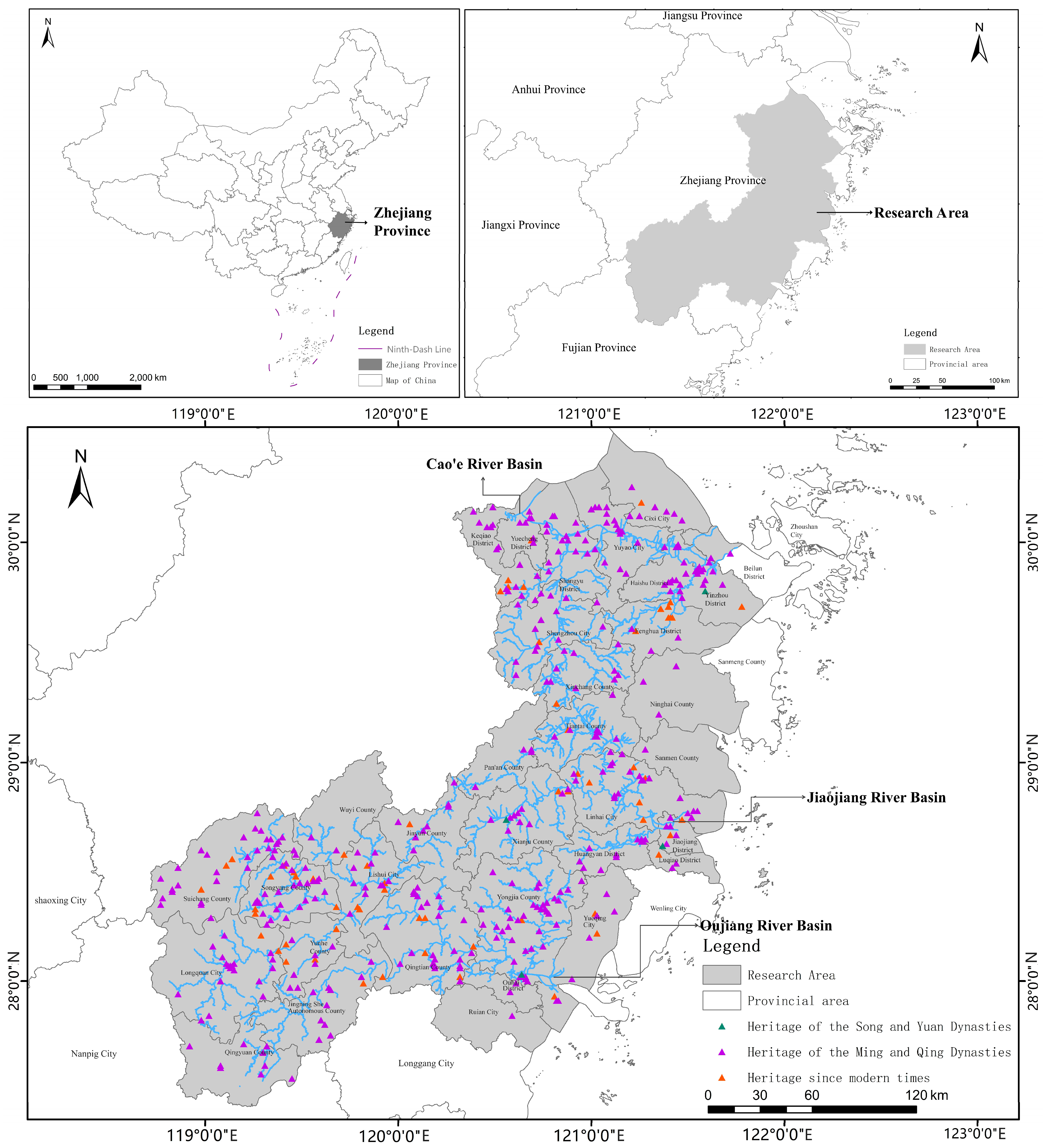
- Research samples were collected through dual sources. ① Official heritage lists: Given that National Key, Provincial, and Municipal/County Key Cultural Relics Protection Units are selected or designated based on unified standards and represent the most outstanding historical and cultural value [47], this study incorporates: The 1st to 8th batches of National Key Cultural Relics Protection Units in Zhejiang Province (first batch: March 1961; eighth batch: October 2019) published on the official website of the National Cultural Heritage Administration (http://www.ncha.gov.cn/ (accessed on 30 April 2025)); The 1st to 8th batches of Provincial and Municipal/County Key Cultural Relics Protection Units (first batch: April 1961; eighth batch: July 2023) published by the Zhejiang Provincial Cultural Heritage Bureau (http://www.zj.gov.cn (accessed on 30 April 2025)). ② Supplementary academic literature: Representative vernacular architectural heritage reflecting regional characteristics was added by reviewing monographs such as Ancient Architecture of Zhejiang (Yang Xinping et al., 2015 [48]), Zhejiang Vernacular Dwellings (Institute of Architectural History, China Academy of Building Research, 2018 [49]), Zhejiang Vernacular Dwellings (Ding Junqing et al., 2009 [50]), and local chronicles. After excluding a small number of data points with uncertain dating, 570 valid research samples were finalized as of July 2023. (the vernacular architectural heritage referred to in this paper is an important type of traditional Chinese architecture, encompassing residential houses, ancestral halls, guildhalls, academies, etc. [51]).
- (2)
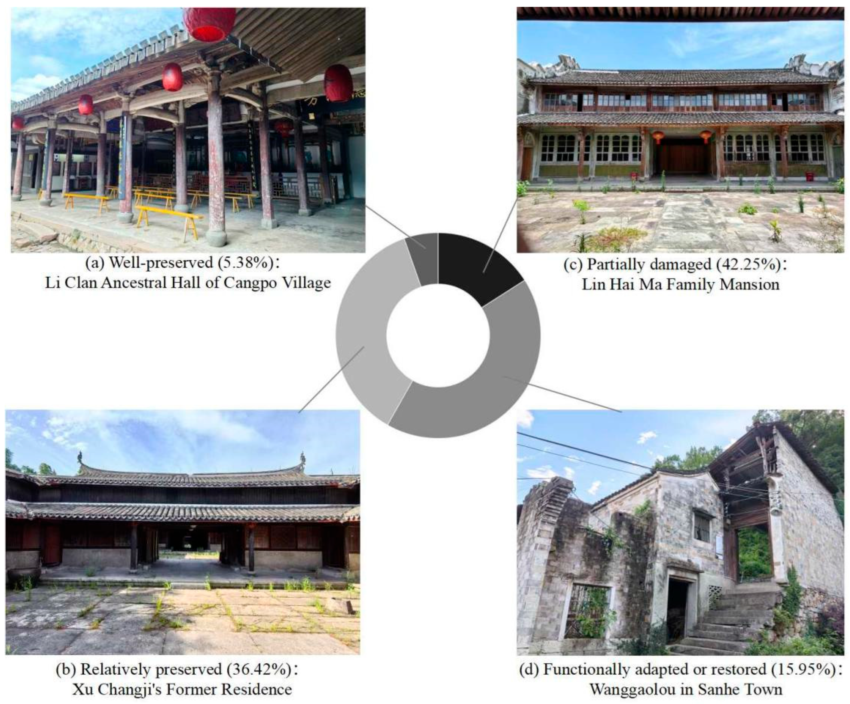
- Spatiotemporal Characteristics Analysis of Samples. The construction periods of the 570 research samples were categorized into three historical periods: the Song-Yuan Dynasties, the Ming-Qing Dynasties, and the Modern Era (post-Qing). Analysis revealed that the Ming-Qing period has the highest number (465), followed by the Modern Era (101), with only 4 dating from the Song-Yuan period. The preservation status of these heritage sites can be broadly classified into four categories: Category 1: Well-preserved (approx. 5.38% of the total sample), primarily consisting of National Key Protection Units; these dwellings retain their original architectural form, structural system, and decorative features intact, showing no significant natural or anthropogenic damage, possessing complete cultural identifiability and historical authenticity; Category 2: Relatively well-preserved (36.42%); the original form is largely intact, but potential risks from natural disasters exist, necessitating enhanced preventive conservation measures; Category 3: Partially damaged (42.25%), currently the largest category; typically exhibiting damage to local structural components, which somewhat affects the recognition of cultural symbols, yet the overall building structure, spatial layout, and core historical features remain clearly discernible, holding significant historical and cultural research value; Category 4: Functionally adapted or restored (15.95%); having undergone restoration or partial functional changes (e.g., conversion to public spaces), but the main structure and traditional appearance are partially retained; this category reflects the practical characteristics of dynamic conservation and adaptive reuse of cultural heritage (Figure 2).
3.2. Research Methods and Approach
- (1)
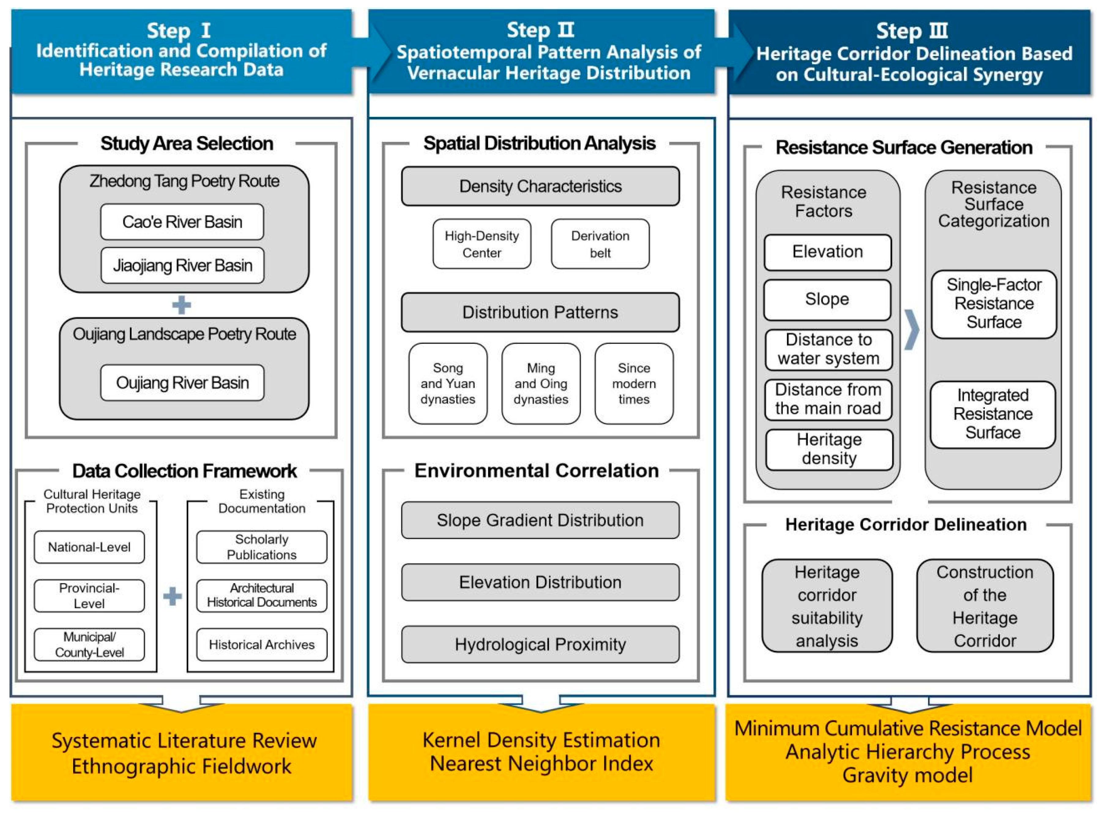
- Construction of geographic information database: Based on the 570 samples identified in Section 3.1, longitude/latitude coordinates and spatial attribute data were collected via the Guihuayun platform (http://www.guihuayun.com (accessed on 30 April 2025)). On the ArcGIS 10.8 platform, a Geographic Information System (GIS) database for the basin’s vernacular heritage was constructed by integrating core fields such as spatial location, period attributes, and environmental parameters (Figure 3 Step I).
- (2)
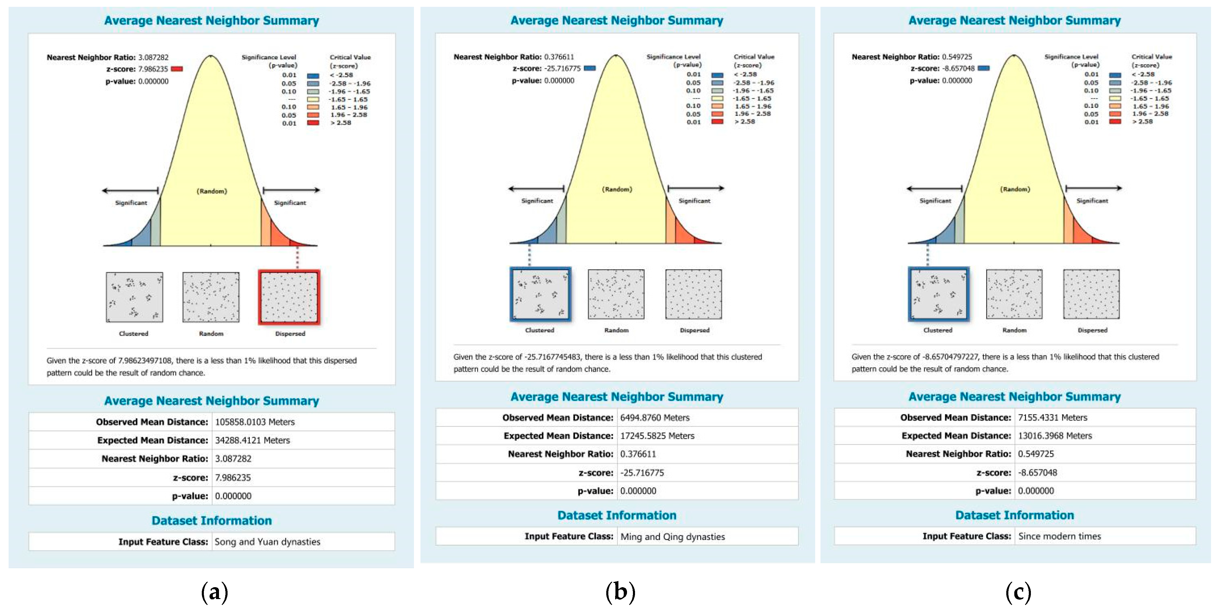
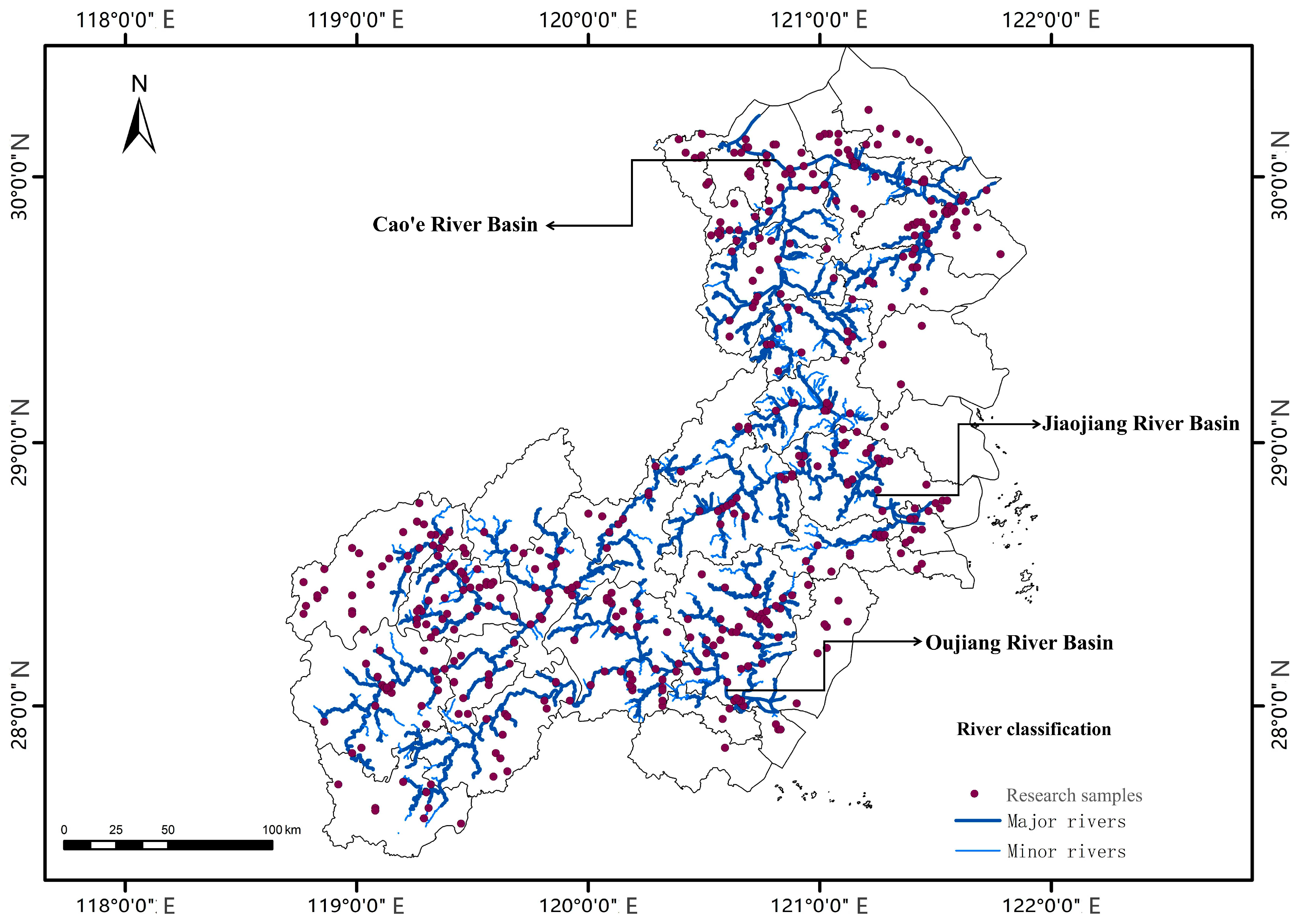
- Analysis of heritage spatiotemporal patterns and their relationship with physical geography: Employing Kernel Density Estimation (KDE) (Table 1(a)) with a bandwidth of 5 km to visualize spatial agglomeration trends of the heritage; combining this with the Nearest Neighbor Index (NNI) (Table 1(b)) using distances in kilometers for quantitative identification of distribution patterns; and utilizing DEM and GIS spatial analysis techniques to quantitatively analyze the coupling patterns between vernacular heritage distribution and factors such as elevation, slope, and hydrology (Figure 3 Step II).
- (3)
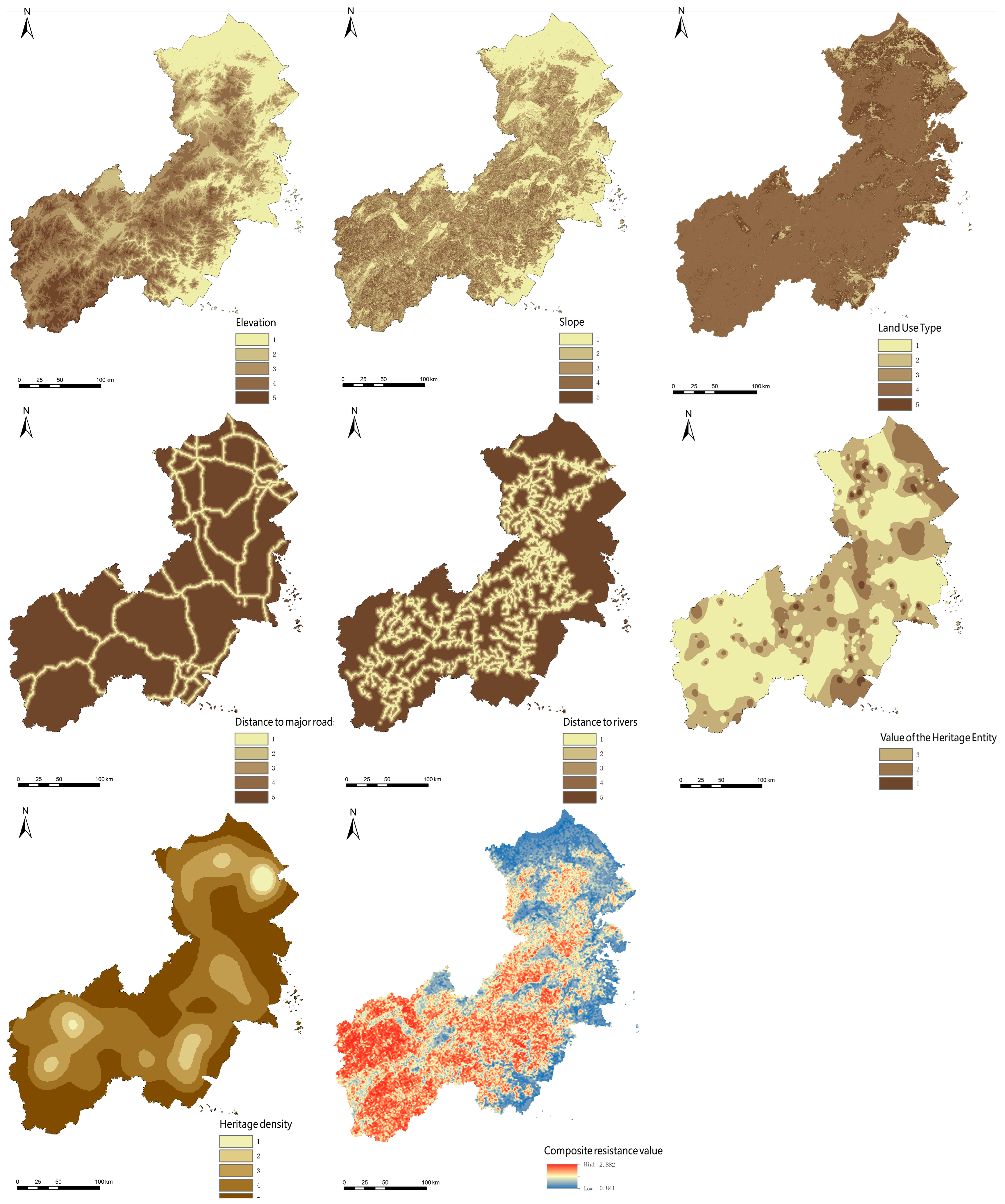
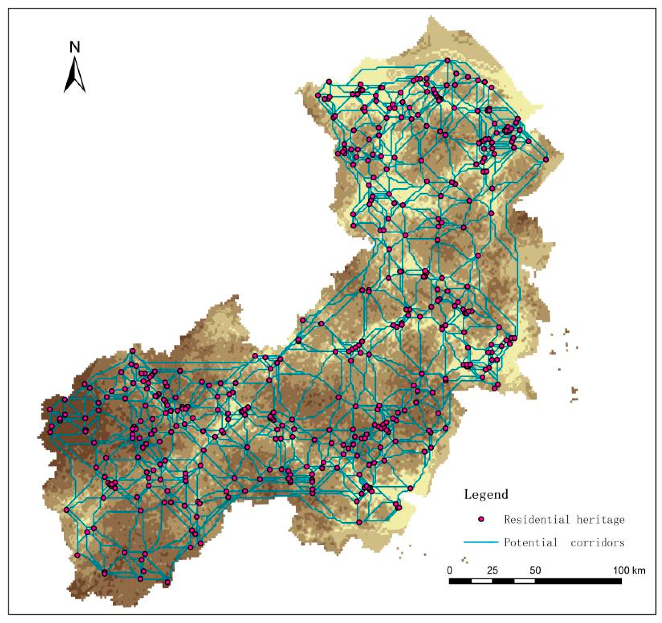
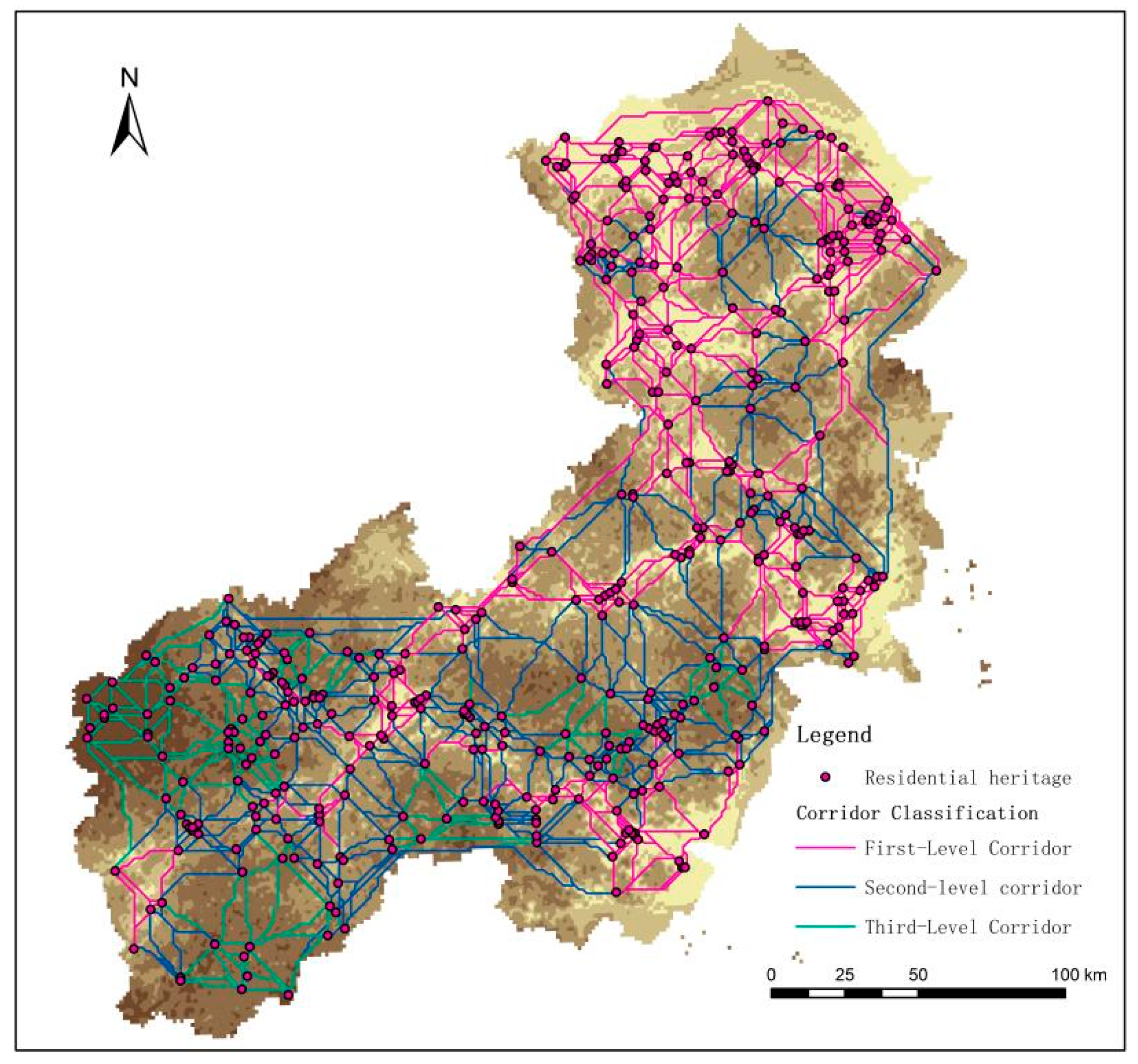
- Heritage corridor construction: Firstly, establishing evaluation indicators across three dimensions—natural environment, transportation conditions, and heritage clustering—using the Analytic Hierarchy Process (AHP); secondly, assessing the suitability for heritage corridor construction within the Cao’e–Jiaojiang–Oujiang Basin through the Minimum Cumulative Resistance (MCR) (Table 1(c)) model; and finally, grading the heritage corridors based on the Gravity Model (Table 1(d)) to construct the overall heritage corridor framework for the Cao’e–Jiaojiang–Oujiang Basin vernacular heritage (Figure 3 Step III).
| Formula | Research Method | Model |
|---|---|---|
| (a) | Kernel Density Estimation F(x) | |
| (b) | Nearest Neighbor Index R | |
| (c) | Minimum Cumulative Resistance MCR | |
| (d) | Gravity Model Fij |
4. Spatial Distribution Characteristics of Traditional Vernacular Dwellings
4.1. Spatial Distribution Density Characteristics
4.2. Spatial Distribution Pattern Characteristics
5. Association Between Traditional Vernacular Dwelling Distribution and the Natural Environment
5.1. Association with Topography and Geomorphology
5.2. Association Between Spatial Distribution and Hydrology
6. Heritage Corridor Construction
6.1. Resistance Factor Selection
6.2. Corridor Suitability Analysis
6.3. Heritage Corridor Establishment
7. Conclusions and Outlook
7.1. Conclusions
- (1)
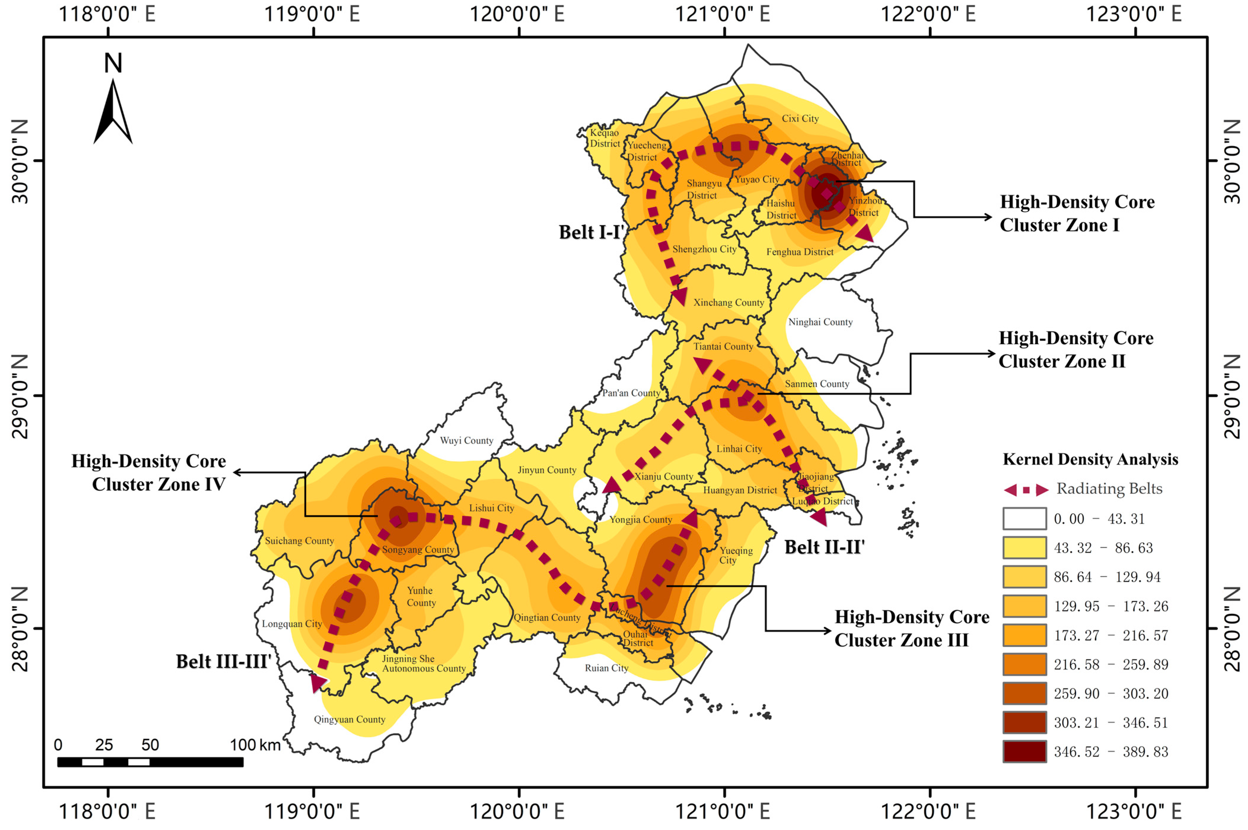
- Theoretical dimension: For the first time, this paper proposes the “four cores and three belts” spatial differentiation pattern of vernacular heritage in river basins, revealing the symbiotic mechanism between the scale effects of cultural diffusion and geographical constraints, thereby deepening the understanding of heritage spatial evolution in the Jiangnan water network region.
- (2)
- Methodological dimension: This paper constructs a “dual-model evaluation system” (MCR resistance model + Gravity Model classification), achieving multi-factor quantitative assessment and spatial grading of heritage corridor suitability, and providing a reusable technical pathway for linear cultural heritage conservation.
- (3)
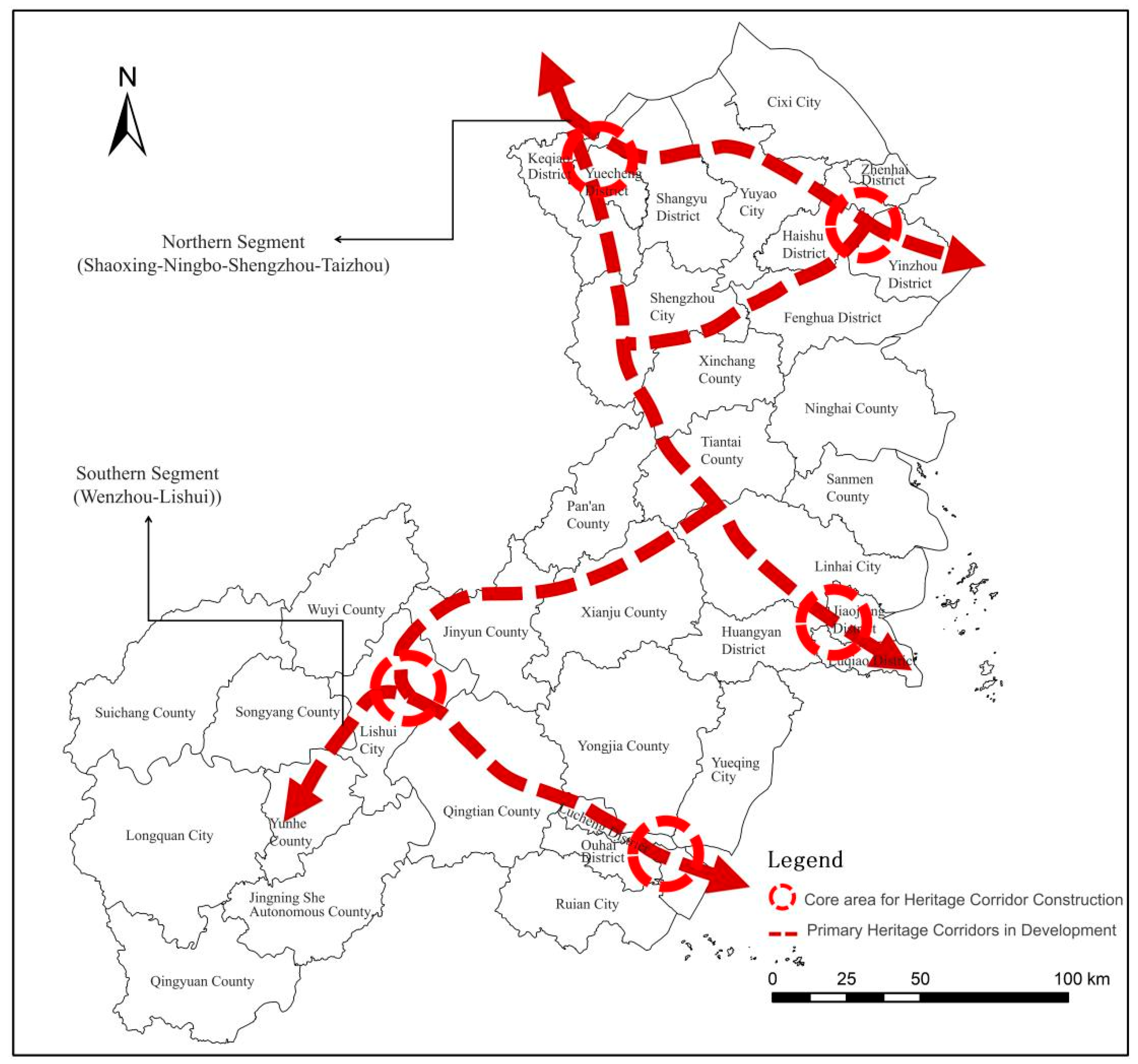
- Practical dimension: This paper proposes a dual-segment corridor structure (Shaoxing–Taizhou/Wenzhou–Lishui), transforming dispersed vernacular heritage into interconnected "memory carriers" of linear cultural landscapes. This strategy directly supports Zhejiang Province’s "Eastern Zhejiang Tang Poetry Route" and "Oujiang River Landscape Poetry Route" initiatives, providing a scientific basis for integrating cultural heritage conservation into territorial spatial planning.
7.2. Outlook
- (1)
- Current conservation efforts urgently need to transcend individual restoration and elevate to regional cultural heritage network construction. It is recommended to integrate vernacular heritage protection into Zhejiang’s territorial spatial planning framework, prioritizing alignment with two provincial cultural routes—”Zhedong Tang Poetry Route” and “Oujiang River Landscape Poetry Route”. Using heritage corridor theory, establish a multi-level protection system of “Cultural Route → Heritage Node → Traditional Vernacular Cluster” to provide spatial scientific basis for policymaking.
- (2)
- The formation of vernacular heritage in the basin results from interactions between geographical constraints and human factors. Interdisciplinary integration of historical geography, architectural archaeology, and environmental science is needed to achieve fine-grained understanding of these factors, thereby refining regional genes to support corridor construction logic centered on intrinsic heritage value.
- (3)
- Large-scale linear heritage corridor development in China currently lacks mature paradigms, yet its strategic value and potential are significant. Future work should expand theoretical and practical research to establish cultural corridor theoretical models adapted to China’s urban–rural development context.
Author Contributions
Funding
Data Availability Statement
Conflicts of Interest
References
- Lu, Y. Research on Chinese Vernacular Dwellings over Fifty Years. J. Archit. 2007, 11, 66–69. [Google Scholar]
- Lanier, G.M. Vernacular Architecture in the Twenty-First Century: Theory, Education and Practice. J. Archit. Educ. 2009, 63, 160–161. [Google Scholar] [CrossRef]
- Jiang, L.; Cai, J. Research on the Spatial and Temporal Distribution and Evolution Characteristics of Ancient Architectural Heritage in Southeastern Zhejiang. Sustainability 2023, 15, 16618. [Google Scholar] [CrossRef]
- Setijanti, P.; Defiana, I.; Setyawan, W.; Silas, J.; Firmaningtyas, S.; Ernawati, R. Traditional Settlement Livability in Creating Sustainable Living. Procedia-Soc. Behav. Sci. 2015, 179, 204–211. [Google Scholar] [CrossRef]
- Taylor, K. The Historic Urban Landscape. Managing Heritage in an Urban Century. Landsc. Res. 2014, 39, 326–329. [Google Scholar][Green Version]
- Palang, H.; Helmfrid, S.; Antrop, M.; Alumäe, H. Rural Landscapes: Past processes and future strategies. Landsc. Urban Plan. 2005, 70, 3–8. [Google Scholar] [CrossRef]
- Zhu, G. On the Architectural Culture of the Yue Region. Built Herit. 2021, 2, 70–80. [Google Scholar]
- Anderson, B. Cultural geography III: The concept of ‘culture’. Prog. Hum. Geogr. 2020, 44, 608–617. [Google Scholar] [CrossRef]
- Zhejiang Provincial People’s Government. Zhejiang Provincial Poetry Road Cultural Belt Development Plan; Zhejiang Provincial People’s Government: Hangzhou, China, 2020.
- Conzen, M.R.G. Alnwick, Northumberland: A Study in Town-Plan Analysis; Institute of British Geographers: London, UK, 1960; pp. 6–12. [Google Scholar]
- Schulp, C.J.E.; Levers, C.; Kuemmerle, T.; Tieskens, K.F.; Verburg, P.H. Mapping and modelling past and future land use change in Europe’s cultural landscapes. Land Use Policy 2019, 80, 332–344. [Google Scholar] [CrossRef]
- Hoppert, M.; Bahn, B.; Bergmeier, E.; Deutsch, M.; Epperlein, K.; Hallmann, C.; Müller, A.; Platz, T.V.; Reeh, T.; Stück, H.; et al. The Saale-Unstrut cultural landscape corridor. Environ. Earth Sci. 2018, 77, 58. [Google Scholar] [CrossRef]
- Jin, A.; Zhang, S.; Wang, X. Spatio-temporal pattern of cultural heritage in Zhejiang Province and its association with natural environment: A case study of cultural relics protection units. Chin. Landsc. Archit. 2022, 38, 22–28. [Google Scholar]
- Sun, Y.; Chen, T.; Zhang, M. Research on the development mode of protective tourism in rural landscape heritage sites: A case study of Longmen Ancient Town in Zhejiang. Chin. J. Geogr. 2009, 29, 840–845. [Google Scholar]
- Wu, X. Strategies for Strengthening the Protection of Natural and Cultural Heritage in Zhejiang. Zhejiang Econ. 2003, 24, 44–45. [Google Scholar]
- Zhang, S.; Zou, Y.; Yao, S.; Cao, X. Evaluation and optimization of ecosystem cultural services in rural areas from the perspective of residents: A case study of the Shishili River valley in Zhejiang. Acta Ecol. Sin. 2024, 44, 9458–9469. [Google Scholar]
- Li, M. Disaster risk management of cultural heritage: A global scale analysis of characteristics, multiple hazards, lessons learned from historical disasters, and issues in current DRR measures in world heritage sites. Int. J. Disaster Risk Reduct. 2024, 110, 104633. [Google Scholar] [CrossRef]
- Perez-Alvaro, E. Climate change and underwater cultural heritage: Impacts and challenges. J. Cult. Herit. 2016, 21, 842–848. [Google Scholar] [CrossRef]
- UNESCO. Convention for the Safeguarding of the Intangible Cultural Heritage; UNESCO: Paris, France, 2003. [Google Scholar]
- Loren-méndez, M.; Mata-olmo, R.; Ruiz, R.; Pinzón-ayala, D. An Interdisciplinary Methodology for the Characterization and Visualization of the Heritage of Roadway Corridors. Geogr. Rev. 2016, 106, 489–515. [Google Scholar] [CrossRef]
- Yu, K.; Xi, X.; Li, D.; Li, H.-L.; Liu, K. Construction of the National Linear Cultural Heritage Network of China. Hum. Geogr. 2009, 24, 11–16. [Google Scholar]
- Ahern, J. Greenways as a planning strategy. Landsc. Urban Plan. 1995, 33, 131–155. [Google Scholar] [CrossRef]
- Laven, D.; Ventriss, C.; Manning, R.; Mitchell, N. Evaluating U.S. National Heritage Areas: Theory, Methods, and Application. Environ. Manag. 2010, 46, 195–212. [Google Scholar] [CrossRef] [PubMed]
- Oikonomopoulou, E.; Delegou, E.T.; Sayas, J.; Moropoulou, A. An innovative approach to the protection of cultural heritage: The case of cultural routes in Chios Island, Greece. J. Archaeol. Sci. Rep. 2017, 14, 742–757. [Google Scholar] [CrossRef]
- Wang, Z.; Sun, P. Heritage Corridors—A Relatively New Approach to Heritage Conservation. Chin. Landsc. Archit. 2001, 5, 86–89. [Google Scholar]
- Chen, L.; Hu, X.; Wei, B.; Long, J.; Luo, Z. Spatial distribution of traditional settlements and suitability analysis of heritage corridors in the Yuan River Basin, Hunan. Mod. Urban Res. 2022, 7, 112–119. [Google Scholar]
- Zhang, J.; Jiang, L.; Wang, X.; Chen, Z.; Xu, S. A Study on the Spatiotemporal Aggregation and Corridor Distribution Characteristics of Cultural Heritage: The Case of Fuzhou, China. Buildings 2024, 14, 121. [Google Scholar] [CrossRef]
- Li, J.; Shan, M.; Qi, J. Coupling coordination development of culture-ecology-tourism in cities along the grand canal cultural belt. Econ. Geogr. 2022, 42, 201–207. [Google Scholar]
- Shao, Y.; Huang, Y. Planning and governance of regional historical and cultural space conservation and development: A case study of the Loire Valley in France. Urban Plan. Inter. 2022, 37, 111–121. [Google Scholar]
- Du, Y.; Shi, C.; Tang, Y.; Chen, C. Research on the spatial construction of heritage corridors in the Yellow River Basin from a watershed perspective. Wenbo 2024, 4, 103–112. [Google Scholar]
- Zhu, Y.J.; Li, Y.H.; Liu, M.N.; Liu, Y.C. Analysis of Major Protection Approaches for Canal World Heritage Sites at Home and Abroad—With Discussion on Protection Strategies for the Grand Canal Cultural Belt in China. Urban Dev. Stud. 2024, 31, 23–27. [Google Scholar]
- Yue, N.; Li, J. Protection Pathways of Cultural Heritage Along the Yellow River Ferry Crossings in Shanxi from the Perspective of Cultural Routes—An Exploratory Study Based on Grounded Theory. J. Arid. Land Resour. Environ. 2023, 37, 102–110. [Google Scholar]
- Zhang, D.; Feng, T.; Zhang, J. Construction of the Wei River Water System Heritage Corridor System in Greater Xi’an. Chin. Landsc. Archit. 2016, 32, 52–56. [Google Scholar]
- Li, W.; Yu, K.; Li, D. Theoretical Framework for Heritage Corridors and the Holistic Protection of the Grand Canal. Urban Probl. 2004, 1, 28–31+54. [Google Scholar]
- Wang, X.; Bi, J. A Preliminary Study on the Construction of the "Eight Rivers" Heritage Corridor in Greater Xi’an. J. Northwest Univ. 2015, 45, 837–841. [Google Scholar]
- Li, X.; Zhu, R.; Shi, C.; Yang, X.; Chen, J.; Wei, K. Research on the construction of intangible cultural heritage corridors in the Yellow River Basin based on geographic information system (GIS) technology and the minimum cumulative resistance (MCR) model. Herit. Sci. 2024, 12, 271. [Google Scholar] [CrossRef]
- Jiang, A.; Sun, F.; Zhang, B.; Wu, Q.; Cai, S.; Yang, Z.; Chang, Y.; Han, R.; Yu, S. Spatiotemporal dynamics and driving factors of vegetation coverage around linear cultural heritage: A case study of the Beijing-Hangzhou Grand Canal. J. Environ. Manag. 2024, 349, 119431. [Google Scholar] [CrossRef] [PubMed]
- Severo, M. Heritage Networks. Managing Network Cultural Heritage with the Web; VDM Verlag Dr. Müller: Saarbrücken, Germany, 2012. [Google Scholar]
- Zhang, S.; Yu, W. Canal Heritage Tourism Utilization Models: Experience and Inspirations from the Grand Canal (Beijing Section). Land 2024, 13, 860. [Google Scholar] [CrossRef]
- Zhang, S.; Liu, J.; Pei, T.; Chan, C.S.; Wang, M.; Meng, B. Tourism value assessment of linear cultural heritage: The case of the Beijing–Hangzhou Grand Canal in China. Curr. Issues Tour. 2021, 26, 47–69. [Google Scholar] [CrossRef]
- Yang, P.; Lu, Y.; Yang, D.; Zhang, Q.Y. Protection and revitalization of cultural heritage from the perspective of heritage corridors—A case study of the Dazhangxi River corridor (Fuzhou section). Planners 2024, 40, 123–130. [Google Scholar]
- Conzen, M.P.; Wulfestieg, B.M. Metropolitan Chicago’s Regional Cultural Park: Assessing the Development of the Illinois & Michigan Canal National Heritage Corridor. J. Geogr. 2001, 100, 111–117. [Google Scholar]
- UNESCO. Convention Concerning the Protection of the World Cultural and Natural Heritage; UNESCO: Paris, France, 1972. [Google Scholar]
- Taylor, K. Cultural landscapes and Asia: Reconciling international and Southeast Asian regional values. Landsc. Res. 2009, 34, 7–31. [Google Scholar] [CrossRef]
- Orbali, D.A.; Woodward, S. A Railway ‘Route’ as a Linear Heritage Attraction: The Hijaz Railway in the Kingdom of Saudi Arabia. J. Herit. Tour. 2008, 3, 159–175. [Google Scholar] [CrossRef]
- Zhejiang Provincial Water Resources Department. Zhejiang River Handbook; Water & Power Press: Beijing, China, 2006. [Google Scholar]
- State Administration of Cultural Heritage. Measures for the Accreditation of National Key Cultural Relics Protection Units; China State Administration of Cultural Heritage: Beijing, China, 2006. [Google Scholar]
- Yang, X. Ancient Architecture of Zhejiang; China Architecture & Building Press: Beijing, China, 2015. [Google Scholar]
- China Academy of Building Research, Architectural History Institute. Zhejiang Traditional Dwellings; Architecture & Building Press: Beijing, China, 2018. [Google Scholar]
- Ding, J.; Yang, X. Zhejiang Traditional Dwellings; Architecture & Building Press: Beijing, China, 2009. [Google Scholar]
- Lu, Y.D. Exploring Research Methodology for Vernacular Dwellings through the Formation Principles of Traditional Residential Architecture. Architect 2005, 3, 5–7. [Google Scholar]
- Wang, X.G.; Jia, B.Q. Overseas Historical and Cultural Heritage Protection Mechanisms and Their Enlightenment for China. Guangxi Ethn. Stud. 2008, 1, 178–185. [Google Scholar]
- Fang, W.; Zhuoqi, L.; Ying, D.; Leye, W. Cultural Heritage Conservation from the Perspective of River Basin. Herit. Archit. 2024, 12, 44. [Google Scholar]
- Xiaoya, Y.; Yi, H.; Wei, D. The Historical and Cultural Spatial Characteristics and Protection Insights of the ‘City-Transportation’ Pattern of the Zhejiang East Canal. Urban Dev. Res. 2024, 31, 30–37. [Google Scholar]
- Liang, F. A Study on the Topography of Taizhou’s Mountains and Rivers. J. Taizhou Teach. Coll. 1995, 1, 64–66. [Google Scholar]
- Zhou, X. The Civilization of Ouhai River in Chuzhou and the ‘Maritime Silk Road’. East. Collect. 2018, 18, 19–29. [Google Scholar]
- Wang, J. Exploring the Methodological System for Recognizing the Historical and Cultural Values of Cities: A Case Study of the Historic City of Traditional Handicrafts, Longquan, Zhejiang. Urban Dev. Res. 2016, 23, 30–38. [Google Scholar]
- Li, Y. Practice and thinking on the living protection of mountainous villages in southern Zhejiang: A case study of Songyang County, Zhejiang Province. Zhejiang Soc. Sci. 2016, 161, 143–150. [Google Scholar]
- Li, J.; Wang, X.; Li, X. Spatial distribution characteristics and influencing fac tors of Chinese traditional villages. Econ Geogr. 2020, 40, 143–153. [Google Scholar]
- Xiang, Y. Regional Water Environment and the Evolution of Prehistoric Culture in Zhejiang. Zhejiang Acad. J. 2015, 4, 44–52. [Google Scholar]
- Lin, F.; Zhang, X.; Ma, Z.; Zhang, Y. Spatial Structure and Corridor Construction of Intangible Cultural Heritage: A Case Study of the Ming Great Wall. Land 2022, 11, 1478. [Google Scholar] [CrossRef]
- Ye, H.; Yang, Z.; Xu, X. Ecological Corridors Analysis Based on MSPA and MCR Model—A Case Study of the Tomur World Natural Heritage Region. Sustainability 2020, 12, 959. [Google Scholar] [CrossRef]
- Sun, Y.; Wang, Y.; Liu, L.; Wei, Z.; Li, J.; Cheng, X. Large-scale cultural heritage conservation and utilization based on cultural ecology corridors: A case study of the Dongjiang-Hanjiang River Basin in Guangdong, China. Herit. Sci. 2024, 12, 44. [Google Scholar] [CrossRef]
- Yue, F.; Li, X.; Huang, Q.; Li, D. A Framework for the Construction of a Heritage Corridor System: A Case Study of the Shu Road in China. Remote Sens. 2023, 15, 4650. [Google Scholar] [CrossRef]
- Wang, J.C.; Zhang, H.Y.; Xie, C.Y.; Chen, M. GIS-Based Suitability Evaluation for Constructing the Intangible Cultural Heritage Corridor of the Grand Canal Cultural Belt. Acta Ecol. Sin. 2025, 45, 5322–5339. [Google Scholar]
- Zhang, Q.; Ge, J. Research on the Construction of Huizhou Heritage Corridor Network from the Perspective of Cultural Ecology. Ind. Constr. 2025, 54, 20–29. [Google Scholar] [CrossRef]
- Zhao, X.; Tang, C.; Dong, P. Research on the Construction of Linear Heritage Composite Tourism Corridors. J. Arid Land Resour. Environ. 2023, 37, 190–199. [Google Scholar]
- He, D.; Wang, Z.; Wu, H. Research on the Construction of Jingdezhen Porcelain Industry Heritage Corridor System Based on MCR and MCA Models. Geogr. Geo-Inf. Sci. 2022, 38, 74–82. [Google Scholar]
- Zhang, Z.; Cao, R.; Kang, F. Spatiotemporal Distribution Characteristics and Heritage Corridor Suitability Construction of Industrial Heritage Along the Taibai Railway. J. Arid Land Resour. Environ. 2024, 38, 40–51. [Google Scholar]
- Zhan, Q.; Guo, H. Suitability Analysis Method for Heritage Corridors Based on GIS and RS. Planners 2015, 31 (Suppl. 1), 318–322. [Google Scholar]
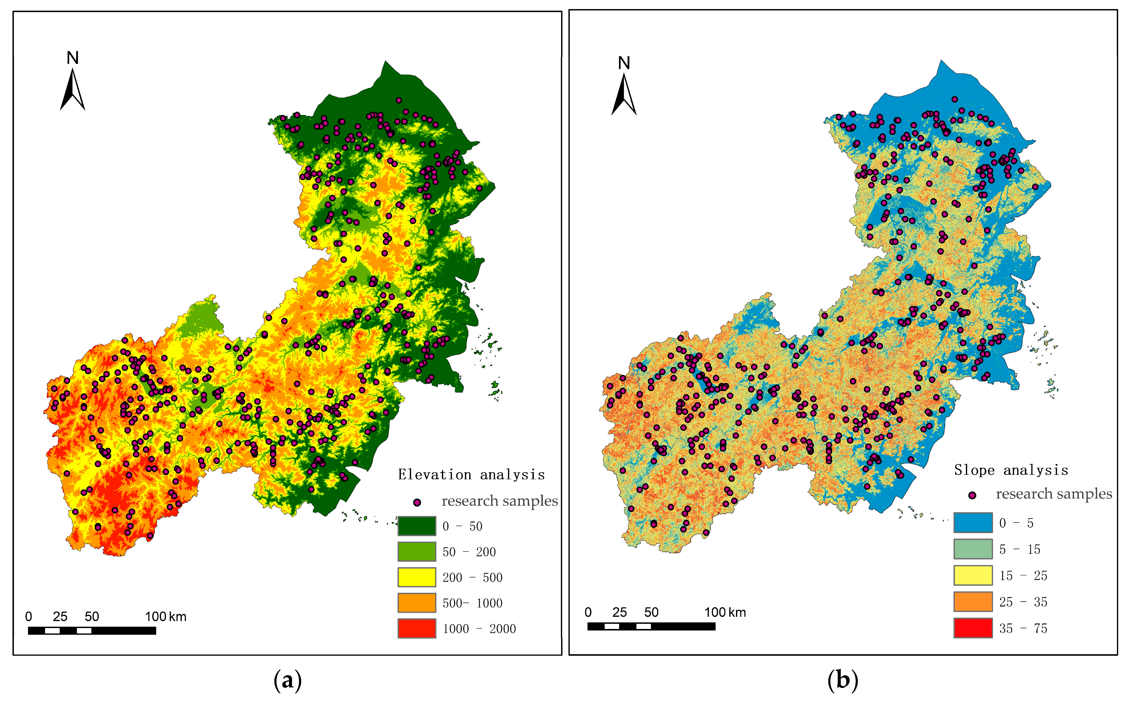

| Elevation Belts | Elevation Range/m | Number of Heritage/pcs | Percentage /% | Spatial Distribution Patterns |
|---|---|---|---|---|
| Plains and Estuarine Belt | 0–50 | 233 | 40.88 | Ribbon-like Density with Distance-Decay from Waterways |
| Lowland Plains Belt | 50–200 | 139 | 21.05 | Scattered Distribution along Secondary Tributaries |
| Hilly and Platform Belts | 200–500 | 129 | 22.63 | Isolated Clusters Anchored to Resource Nodes |
| Mid-Mountain Canyon Belt | 500–1000 | 63 | 11.05 | Beaded Pattern along Ancient Passes and Mountain Defiles |
| Alpine Peaks Belt | >1000 | 6 | 1.05 | Isolated Point Pattern Dominating Strategic High Points |
| Slope Grading | Slope Range | Number of Heritage/pcs | Percentage /% | Typical Functions |
|---|---|---|---|---|
| Flat Areas | <5° | 313 | 54.91 | Agricultural settlements, Trade wharves |
| Gentle Slope Zone | 5°–15° | 120 | 21.05 | Terraced villages, Piedmont stilt houses |
| Moderate Slope Zone | 15°–25° | 77 | 13.51 | Mountain settlements, Fortified dwellings |
| Steep Slope Zone | 25°–35° | 47 | 8.25 | Mining/metallurgy sites, Mountain pass outposts |
| Extremely Steep Slope Zone | >35° | 13 | 2.28 | Plank-road stations, Extreme dwellings |
| Distance from River/m | Below 500 | 500–1000 | 1000–1500 | 1500–2000 | Above 2000 |
|---|---|---|---|---|---|
| Number of Heritage/pcs | 168 | 217 | 96 | 53 | 36 |
| Percentage/% | 29.47 | 38.07 | 16.84 | 9.30 | 6.32 |
| Target Level | Standards Level | Sub-Factor Layer | Assignment | Weight |
|---|---|---|---|---|
| Natural Environment | Elevation | <50 | 1 | 0.20 |
| 50–200 | 2 | |||
| 200–500 | 3 | |||
| 500–1000 | 4 | |||
| >1000 | 5 | |||
| Slope | <5 | 1 | 0.18 | |
| 5–15 | 2 | |||
| 15–25 | 3 | |||
| 25–35 | 4 | |||
| >35 | 5 | |||
| Land use type | Construction land | 1 | 0.12 | |
| Grassland | 2 | |||
| Forest land | 3 | |||
| Cultivated land | 4 | |||
| Bare land | 5 | |||
| Traffic conditions | Distance to water system | <500 | 1 | 0.10 |
| 500–1000 | 2 | |||
| 1000–1500 | 3 | |||
| 1500–2000 | 4 | |||
| >2000 | 5 | |||
| Distance from the main road | <500 | 1 | 0.10 | |
| 500–1000 | 2 | |||
| 1000–1500 | 3 | |||
| 1500–2000 | 4 | |||
| >2000 | 5 | |||
| Cultural Heritage Accumulation | Heritage density | 0–86.63 | 1 | 0.10 |
| 86.63–173.36 | 2 | |||
| 173.36–259.89 | 3 | |||
| 259.89–303.20 | 4 | |||
| 303.20–389.83 | 5 | |||
| Value of the Heritage Entity | National Heritage Site | 1 | 0.15 | |
| Provincial Heritage Site | 2 | |||
| Municipal/County Heritage Sites and Local Heritage | 3 |
Disclaimer/Publisher’s Note: The statements, opinions and data contained in all publications are solely those of the individual author(s) and contributor(s) and not of MDPI and/or the editor(s). MDPI and/or the editor(s) disclaim responsibility for any injury to people or property resulting from any ideas, methods, instructions or products referred to in the content. |
© 2025 by the authors. Licensee MDPI, Basel, Switzerland. This article is an open access article distributed under the terms and conditions of the Creative Commons Attribution (CC BY) license (https://creativecommons.org/licenses/by/4.0/).
Share and Cite
Jiang, L.; Cai, J.; Fan, Y. Spatiotemporal Distribution and Heritage Corridor Construction of Vernacular Architectural Heritage in the Cao’e River, Jiaojiang River, and Oujiang River Basin. Land 2025, 14, 1484. https://doi.org/10.3390/land14071484
Jiang L, Cai J, Fan Y. Spatiotemporal Distribution and Heritage Corridor Construction of Vernacular Architectural Heritage in the Cao’e River, Jiaojiang River, and Oujiang River Basin. Land. 2025; 14(7):1484. https://doi.org/10.3390/land14071484
Chicago/Turabian StyleJiang, Liwen, Jun Cai, and Yilun Fan. 2025. "Spatiotemporal Distribution and Heritage Corridor Construction of Vernacular Architectural Heritage in the Cao’e River, Jiaojiang River, and Oujiang River Basin" Land 14, no. 7: 1484. https://doi.org/10.3390/land14071484
APA StyleJiang, L., Cai, J., & Fan, Y. (2025). Spatiotemporal Distribution and Heritage Corridor Construction of Vernacular Architectural Heritage in the Cao’e River, Jiaojiang River, and Oujiang River Basin. Land, 14(7), 1484. https://doi.org/10.3390/land14071484


