Abstract
Century-long land-use practices have a profound impact on soil physical and chemical properties, with direct implications for soil health and agricultural sustainability. This study aimed to assess the effects of four contrasting land uses—remnant vegetation, pasture, cultivated areas, and loafing areas—on the physical and chemical properties of Red Ferrosols in the Toowoomba region, Queensland, Australia. Soil samples were collected from upper and lower slope positions for each land use. Physical properties, including bulk density, porosity, water retention, and permeability, as well as chemical properties such as organic carbon, nitrogen, phosphorus, and potassium, were analysed. The results showed that remnant vegetation preserved the most favourable soil conditions, with lower bulk density, higher porosity, and greater water retention. Cultivated areas exhibited significant soil degradation, marked by compaction, reduced infiltration, and depleted organic matter. Loafing areas displayed localised nutrient enrichment but higher compaction due to livestock trampling. Pastures maintained intermediate conditions, retaining some beneficial soil characteristics. These findings emphasise the critical need for sustainable land management strategies to protect soil structure and function, supporting the long-term productivity and resilience of Red Ferrosols.
1. Introduction
Australia’s agricultural sector has grown substantially over the past two decades, positioning it to benefit from strong global commodity markets. Agricultural production has undergone significant changes in recent decades, with a shift towards horticultural crops, meat, oilseeds, and pulses [1]. These changes in land use often involve intensive practices that can negatively affect soil health.
Soils are highly diverse in Australia, with Ferrosols, particularly in tropical and subtropical regions, playing a key role in supporting agricultural production. Their distribution influences land use, productivity, and environmental management across the country [2].
Red Ferrosols (Ferralsols and Nitisols in the World Reference Base, WRB) [3], a prominent soil type in Southeast Queensland, are particularly susceptible to physical degradation under unsustainable land-use practices. Historically used for crops such as potatoes, these soils are now predominantly used for pasture. The conversion of forested lands to agriculture has led to significant soil organic carbon loss [4,5]. To prevent degradation and preserve the physical quality of the soil and the environment, it is necessary to quantify the impacts of different land use and management systems.
The main causes of shifting land use are associated with a mix of biophysical, socio-economic, and political factors, but are mainly driven by economic viability as farms in Australia are operated as a business. Financial pressure and hardship, as a key socio-economic factor, significantly impact land-use practise, often promoting deforestation, overgrazing, intensive agriculture, and the overuse of natural resources [1].
Given the finite nature of soil and its limited resilience in maintaining vital functions, understanding the severity of environmental disturbances caused by inadequate agricultural practices is critical. This is especially important for vulnerable soils such as Red Ferrosols, where structural degradation is difficult to reverse. The assessment and long-term monitoring of key physical indicators such as soil organic carbon and water balance will be essential for research and land management strategies aimed at mitigating climate-related and land-use impacts [6,7].
In particular, for Ferrosols, land-use changes manifest as various forms of soil degradation, with detrimental consequences such as soil compaction, heavy machinery traffic, and excessive animal trampling compacting soil, decreasing porosity, and hindering water infiltration and gas exchange (aeration) [8,9,10]; erosion, removal of vegetation cover, increases susceptibility to water and wind erosion, leading to the transport of soil particles and a decline in soil structure [11,12]; and organic matter loss, inappropriate agricultural practices, and the removal of native vegetation can deplete soil organic matter, negatively impacting both soil structure and fertility [10,13].
While our primary emphasis is on physical characteristics and organic carbon decline, we also assessed phosphorus (P) and potassium (K) levels due to their critical roles in red soils, as Ferrosols are typically acidic soils prone to P-fixation, which can lead to P deficiencies in plants. P-fixation occurs when phosphorus binds strongly to iron and aluminium oxides in the soil, making it less available for plant uptake. This characteristic makes P management crucial in these soils to ensure adequate nutrient availability for plant growth. Potassium is essential for maintaining turgor pressure in plant leaves, which is critical for overall plant health and productivity. The continuous removal of plant material through harvesting can significantly deplete soil K reserves over time [14].
Understanding the main drivers of land-use and land-cover change is essential to mitigate their adverse impacts on soil properties and to promote sustainable resource management [15].
The first step in the conversion to arable land is the removal of natural vegetation. This change in land-use is a well-documented driver of soil degradation, affecting many soils’ physical properties [15,16], especially Ferrosols that are vulnerable to physical disturbance. Excessive soil disturbance during forestry clearing, for instance, can lead to significant soil removal with uprooted roots, increased erosion, and losses of macro- and micronutrients [17]. This disturbance also alters soil structure, affecting water retention capacity and disrupting soil biota [18]. Similarly, agricultural practices like tillage and livestock grazing can compact soil, reduce pore space, and hinder essential processes like root growth, infiltration, and drainage of water [8,16].
Different land-use systems adopt soil preparation techniques that significantly influence physical soil properties, directly affecting soil structure [8]. Land-use change, often accompanied by a decline in vegetation cover, leads to a reduction in soil organic matter and available nutrients, decreasing land productivity. Furthermore, this loss of vegetation cover can worsen erosion, particularly of the topsoil, which reduces the effective soil depth. Soil fertility is a complex characteristic with inherent variability. Understanding the main drivers of land-use and land-cover change is essential to mitigate their adverse impacts on soil properties and to promote sustainable resource management [15].
The main objective of this study is to compare the current physical and chemical properties of soils under different long-term land uses, including remnant vegetation, pasture, and cropping. These land uses have been established on the same property for over 100 years, providing an opportunity to assess the impacts of continuous land use on soil properties.
This case study presents an opportunity to assess the long-term impacts of land-use change on Red Ferrosols under real farming conditions. Our research investigates adjacent land uses with over a century of consistent management by the same landholder, minimising confounding variables such as climate, soil type, and management history. The findings offer valuable insights into the physical and chemical degradation processes associated with agricultural intensification, providing evidence-based guidance for sustainable land-use planning. This information is particularly relevant for farmers, land managers, and policymakers aiming to maintain productivity and soil health in one of Australia’s most important agricultural regions.
2. Materials and Methods
2.1. Regional Context
This study aims to evaluate the impact of long-term land-use practices (pasture and cropping for dairy production) on the physical and chemical properties of Red Ferrosols compared to remnant vegetation in the Toowoomba region. By analysing these changes, we can assess potential sustainability indicators for this soil type under different land-use scenarios.
This research was conducted as an on-farm case study to assess how over a century of contrasting land uses affected the physical and chemical properties of Red Ferrosols. The study was carried out on a single farm with a well-documented land-use history, where different land uses had been established on adjacent plots for more than 100 years.
To capture the variability associated with land use and landscape position, we sampled four land-use types, remnant vegetation, pasture, cultivated area, loafing area, and two slope classes, high and low slopes (except for the loafing area, where only a low slope exists).
In each combination of land use and slope, eight replicate soil cores were collected for physical analyses, along with disturbed soil samples for chemical analyses, at 10 cm depth. The adjacent layout of the land uses minimised climatic and parent material variability, allowing a direct comparison of long-term management impacts on soil properties.
Ferrosols in this region offer significant agricultural potential due to their depth, stability, and drainage characteristics. However, addressing their nutrient deficiencies and mitigating the risks of acidification and erosion are critical for sustainable soil management. By implementing targeted interventions, these soils can support productive and environmentally sustainable agricultural systems [2].
Specifically, as a case study, we compare the soil properties of remnant vegetation reestablished after clearing in the early 1900s with those of pastures and croplands used for dairy production for over a century. Understanding these impacts is crucial for developing sustainable land-use practices that support soil health and productivity.
2.2. Characterisation of Study Areas
The study area is in a rural locality within the Toowoomba Region, Queensland, Australia (Figure 1); all sampling was conducted at the site located at latitude −27.245451 and longitude 151.980724, at an elevation of approximately 700 m above sea level. The region has a warm, humid subtropical climate, characterised by hot summers and cool winters. Average maximum air temperatures reach around 28 °C in summer and 17 °C in winter (Bureau of Meteorology), and the average minimum air temperatures reach around 17 °C in summer and 6 °C in winter. Most rainfall occurs between November and March, with an annual average of approximately 735 mm.
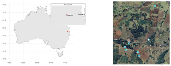
Figure 1.
Pineland’s location on the Australian map with a zoomed-in view of Queensland.
Red Ferrosols are a dominant soil type in agricultural regions of Queensland, including the Toowoomba area. These soils are derived from basaltic parent material and are typically deep, well-drained, and clay-rich, with a structured profile that promotes good water retention and root penetration [19,20]. In the Atherton Tablelands, similar Red Ferrosols display clay contents ranging from 50% at the surface to 75% at 1 m depth, pH values between 5.9 and 6.6, and bulk density (BD) values ranging from 1.1 to 1.3 g/cm3, conditions that are considered optimal for root growth and water movement. In the Toowoomba region, Red Ferrosols have also been identified as fertile but phosphorus-fixing soils, requiring careful nutrient and organic matter management to maintain productivity [21]. These soils are often used for intensive cropping, yet their structural integrity can degrade under conventional tillage, underscoring the need for sustainable land management practices.
A synchronous (conducted at the same time) field study was designed with four land-use types established in adjacent (side-by-side) locations to minimise climatic variation. These land uses were as follows: (i) remnant vegetation, (ii) pasture, (iii) cultivated area, and (iv) loafing area. All locations shared the same soil type, a Red Ferrosol.
On slope terrains, contouring is a key land management technique used at this site to mitigate soil loss and improve water infiltration. Contour farming involves aligning agricultural activities along the natural contours of the land, helping to slow runoff and reduce erosion. This practice is particularly effective on Red Ferrosols due to their susceptibility to surface crusting and erosion when exposed to heavy rainfall.
Sampling sites within each land-use category were selected based on uniform topographic and vegetation characteristics and accessibility to ensure comparability and minimise microenvironmental variability.
2.3. History over the Years
This study investigated the long-term impacts of land use on soil properties by comparing four adjacent sites with established land-use histories exceeding 100 years. The property we selected was owned by the same family for several generations and had reliable historical land-use data. Within the farmer’s property, four sites with different land uses were selected. These sites represented remnant vegetation as a substitute for natural vegetation, pasture, cultivated area, and loafing area. It is important to emphasise that the sites have been farmed by the same landholders since clearing and have an excellent anecdotal, though reliable, record of land-use history for the past 100 years.
The remnant vegetation site is dominated by a mixed-species canopy with Cypress pine (Callitris glaucophylla) as the primary tree species alongside Eucalyptus species. Tree heights range from 10 to 30 m, and the ground layer can be grassy or shrubby.
The pasture site is a monoculture of Kikuyu grass (Pennisetum clandestinum), a perennial mat-forming grass commonly used in dairy farming. Kikuyu thrives in moderately acidic soils (pH 5.5–7.0) but tolerates soils with a pH as low as 4.5.
The cultivated area has been under a forage sorghum–oat rotation for the past five years, with Dolichos lablab previously included in the rotation. All crops are harvested for silage production used to feed dairy cattle.
The loafing area is a small paddock where dairy cows congregate during management periods, resulting in a localised accumulation of organic matter compared to other land uses.
2.4. Soil Sampling and Analysis
In each of the four land-use and management systems, eight replicate soil samples with preserved structure were collected from the topsoil using core rings (12.5 cm diameter × 8.5 cm height) for physical analyses. Samples with altered structure were also collected and air-dried, ground, and sieved to pass through a 2 mm mesh.
The adjacent layout of the land-use types ensured that climatic, geological, and topographic variables were consistent across sites, allowing observed differences in soil properties to be attributed primarily to management practices.
The samples with preserved structure were saturated and subjected to various tensions in a Richards chamber. Afterward, the total porosity (porosity at saturation), biopores (pores drained at a tension of 0.01 bar), aeration pores (pores drained at a tension of 0.1 bar), field capacity (water retained at a tension of 0.1 bar), permanent wilting point (water retained at a tension of 15 bar), and available water were calculated [22]. BD was determined on the soil with preserved structure [23]. Biopores were measured using a sand table at 10 cm suction. Hydraulic conductivity (Ks) was calculated using the falling head method (FHM) by measuring the time required for the water level in the core to drop at least 1 cm [24].
Soil sorptivity was determined on the undisturbed cores using a mini-disk infiltrometer with a pressure head of −2 cm on the preserved soil. Sorptivity was calculated based on the infiltration distance of the wetting front within the infiltrometer tube over time [25].
Total carbon (C) and nitrogen (N) were analysed in disturbed soil samples using a LECO 928 (St. Joseph, MI, USA) analyser set at 1250 °C [26]. For the analysis of phosphorus (P) and potassium (K) using the methods of Cowell, soil pH was measured using a 1:5 soil-to-deionised water suspension [27].
Particulate organic matter (POM) represents the fraction of soil organic matter composed of relatively un-decomposed plant residues and biological material that is light and weakly associated with soil minerals. It is considered an important indicator of soil carbon dynamics and quality [28]. To separate POM, soil samples were dispersed using a sodium hexametaphosphate ((NaPO4)6) solution (15 mL per liter of deionised water) with mechanical shaking. After dispersion, the mixture was allowed to settle so that heavier particles (≥50 µm) sedimented, while the lighter POM fraction remained suspended. The suspension was then sieved through a 45 µm mesh to collect the POM fraction [29]. This procedure quantifies the organic material not tightly bound within the mineral matrix.
Statistical analyses were performed using R software version 2024.04.2 [30] to assess the effects of land use, elevation, and their interactions on soil physical and chemical properties. Analysis of variance (ANOVA) was conducted to test for significant differences in soil properties between land uses at a significance level of α = 0.05. For properties exhibiting significant land-use effects, the LSD test was employed for multiple comparisons of means, applying a 95% family-wise confidence level (Figure 2). Prior to ANOVA, data were assessed for normality and homogeneity of variances using Shapiro–Wilk and Bartlett’s tests, respectively. Data transformations were applied when necessary to meet ANOVA assumptions.
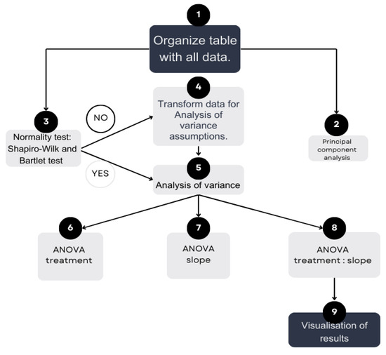
Figure 2.
Statistical analyses flow chart.
3. Results
The analysis of treatment effects is provided in Table 1 and Table 2. The stark contrast between remnant vegetation and cultivated areas highlights the need for sustainable land-use practices, such as reduced tillage, organic amendments, and cover cropping, to mitigate soil compaction.

Table 1.
Descriptive statistics of soil physical and chemical properties under different long-term land uses and slope positions in Red Ferrosols.
Table 2.
ANOVA p-values for soil properties (0–10 cm layer) under treatment, slope, and their interaction.
Table 2 shows the ANOVA results, indicating whether there are differences between treatments, slope, or their interaction, where ns means no significant difference, and the p-values, but only for those where p < 0.05, represent a significance level of 5%.
Figure 3 shows the distribution of the results for each variable that exhibited a significant difference in the ANOVA interaction treatment: slope.
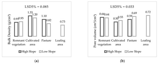
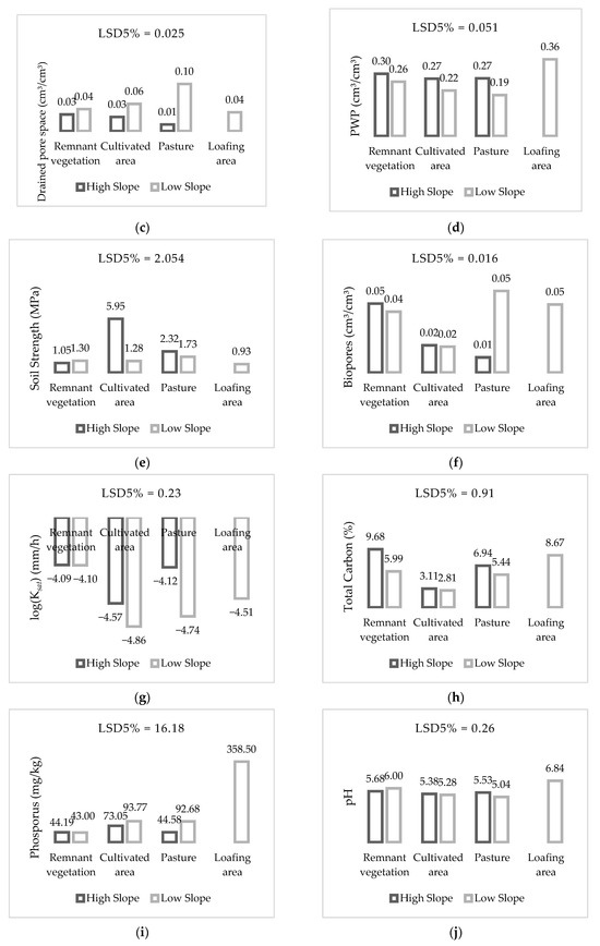
Figure 3.
The distribution of the results for each variable that showed a significant difference in the ANOVA interaction treatment: slope, where (a) is bulk density, (b) pore volume, (c) drained pore space, (d) PWP, (e) soil strength, (f) biopores, (g) log(Ksat), (h) total carbon, (i) phosphorus and (j) pH.
Soil physical quality varied considerably across land uses. The remnant vegetation site (both high and low slope) showed lower BD (0.91 and 0.95 g/cm3) and higher pore volume (0.66 and 0.64 cm3/cm3), indicating a well-structured soil with limited compaction. These values are consistent with those of natural systems that have not been subjected to significant mechanical or animal disturbance. According to the literature, BD below 1.2 g/cm3 and pore volumes above 0.50 cm3/cm3 are considered optimal for root development and water movement [31].
Under long-term cultivated conditions compared to remnant vegetation, BD increased by approximately 42%, pore volume decreased by approximately 22%, soil strength dramatically increased by around 362% on high slopes, and bioporosity decreased by about 50%, likely due to continuous tillage and machinery traffic. This is supported by the low water retention capacity (field capacity ~0.40 cm3/cm3) and limited available water (15–19 mm/10 cm), indicating structural degradation.
Conversely, the loafing area demonstrated a 22% reduction in BD when compared to remnant vegetation and an increase in pore volume by approximately 11%. Being subject to intense animal trampling, it had the lowest BD (0.73 g/cm3) and highest pore volume (0.72 cm3/cm3). This apparent looseness can be explained by the high accumulation of organic matter from manure, which creates a spongy surface layer. However, soil strength was also low (0.9 MPa), raising concerns about soil susceptibility to compaction under wet conditions. Although available water was among the highest (32 mm/10 cm), the field capacity (0.68 cm3/cm3) suggests potential risk for saturation and poor aeration.
The pasture site presented intermediate physical values compared to the remnant vegetation, with BD increasing by approximately 18%, pore volume decreasing by around 9%, and soil strength moderately increasing by about 77%. The presence of biopores (up to 0.05 cm3/cm3), especially in the low-slope pasture, indicates biological activity from roots and soil fauna, which helps maintain drainage and aeration.
Across all systems, remnant vegetation also showed the lowest soil strength, a desirable condition for root penetration.
Cultivated soils showed significant reductions compared to remnant vegetation in total carbon by approximately 68%, nitrogen by about 33%, and potassium by around 49%. These values highlight the role of undisturbed organic matter cycling and continuous input from litter. According to [31], increases of over 40% in soil carbon are expected in natural systems compared to cultivated soils.
The loafing area showed substantial increases in phosphorus when compared to remnant vegetation by approximately 733% and potassium by approximately 216%, highlighting risks related to nutrient accumulation and potential runoff. Total carbon in the loafing area decreased slightly by around 10%.
The particulate organic matter (POM) content was also highest in remnant vegetation, confirming higher labile organic fractions that support microbial activity and nutrient cycling.
The pasture site, low and high slope, showed moderate values of carbon (5.4 and 6.9%), nitrogen (0.3 and 0.5%), and POM (0.40 and 0.43%), confirming that grass-based systems can maintain organic matter when managed adequately. However, the relatively lower pH (5.0–5.5) may affect nutrient availability.
Notably, phosphorus levels in remnant vegetation remained low (43–44 mg/kg), reflecting the intrinsic phosphorus fixation of Red Ferrosols, which limits their availability to plants. These low levels are consistent with the need for phosphorus fertilisation in agricultural systems established on these soils.
The principal component analysis (PCA) shown in the biplot (Figure 4) helps visualise the relationships between different land-use treatments and soil physical and chemical properties.
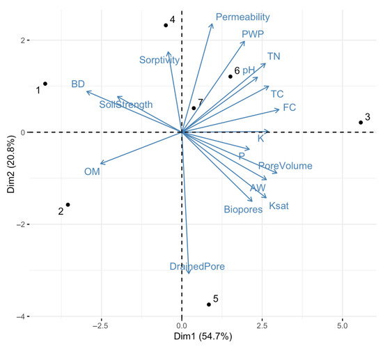
Figure 4.
PCA for the treatments, where (1) is cultivated area (high slope), (2) is cultivated area (low slope), (3) is loafing area (low slope), (4) is pasture (high slope), (5) is pasture (low slope), (6) is remnant vegetation (high slope), and (7) is remnant vegetation (low slope).
The cultivated high-slope area (1) is positioned on the far negative side of Dim1, strongly associated with BD and soil strength and inversely related to most porosity and organic matter indicators, indicating soil compaction and likely degradation. The cultivated low-slope area (2) is located at the negative side of Dim2, related to high organic matter and low particulate organic matter and likely reduced fertility.
Pasture high-slope area (4) is positioned near permeability and sorptivity, suggesting better infiltration and hydrological function, also correlating with remnant vegetation high (6) and low (7) slope areas. Pasture low-slope area (5)’s counterpart aligns with drained pore space, meaning it likely has a better drainage system.
Loafing area (3) is correlated with phosphorus and potassium, which is significant due to the nutrient dynamics influenced by livestock activity. Also, it is associated with pore volume, available water (aw), biopores, and Ksat.
4. Discussion
This study shows the long-term effects of land use on soil quality by comparing four adjacent systems, remnant vegetation, pasture, cultivated land, and loafing area, sharing over a century of consistent land management. Remnant vegetation was used as the reference, representing the baseline for natural soil conditions.
The combined analysis of soil physical and chemical properties highlights how over a century of land-use change has altered the functional capacity of Red Ferrosols. Land uses involving intensive disturbance, such as cropping and loafing areas, have resulted in degraded soil structure (higher BD and reduced porosity) and altered nutrient dynamics (elevated phosphorus and reduced organic carbon). These changes are consistent with previous studies on the impacts of land-use conversion on soil quality [16,32,33,34,35,36,37]. The interplay between structural degradation and nutrient imbalance underscores the need for integrated soil management strategies that protect both physical integrity and fertility in these soils.
While remnant vegetation maintains favourable structural conditions and nutrient cycling, cultivated areas demonstrate clear signs of soil degradation resulting from intensive management practices [33]. These impacts are commonly associated with long-term tillage, absence of cover crops, and intensive silage production. The mechanical disturbance breaks apart soil aggregates and increases susceptibility to erosion and organic matter loss. Reduced infiltration and pore connectivity can also impair root growth and microbial activity, further limiting the soil’s recovery capacity [38].
Our findings demonstrate that long-term conversion of remnant vegetation to pasture or cultivated land leads to measurable declines in critical soil quality indicators, particularly those linked to structural integrity and nutrient cycling [39,40]. Remnant vegetation consistently served as a benchmark for soil health, with superior hydrological and physical characteristics, including lower BD, greater porosity (Ks and biopores), and higher organic matter content.
Pasture systems showed intermediate values of soil quality indicators, with moderately lower compaction and higher available water when compared to cropped areas.
The loafing area presented a different degradation profile. While some nutrient indicators, especially phosphorus and potassium, were elevated—likely due to animal waste accumulation—this came at the cost of significantly compacted topsoil. Trampling pressure in confined areas reduces infiltration and increases the risk of surface runoff.
Cultivated areas, especially those on high slopes, showed clear signs of soil degradation, including increased BD, reduced pore space, lower carbon and nitrogen levels, and acidification, which are changes consistent with repeated tillage, compaction from machinery, and insufficient organic matter inputs. In contrast, pasture and loafing areas showed intermediate conditions; while porosity and available water were comparatively higher, nutrient accumulation in loafing areas raises concerns about leaching and broader environmental risks [41].
5. Conclusions
This study was conducted as a case study on a single property with a well-documented land-use history. While this provided a unique opportunity to assess the long-term effects of land use on Red Ferrosols, it also represents a limitation in terms of the generalisation of the results to broader regions or different soil types. Future research involving multiple sites and temporal monitoring would strengthen the understanding of land-use effects on soil physical and chemical properties in similar landscapes.
By capturing over a century of land-use change, this study reinforces the need for sustainable land management strategies to preserve soil function and long-term agricultural productivity on Red Ferrosols. As an on-farm investigation, it provides rare and critical long-term evidence by quantifying the extent of soil degradation after a century of continuous land use.
The findings from this long-term case study contribute to a better understanding of how different land uses impact soil quality on Red Ferrosols, a key soil type for agriculture in Queensland. Future research should investigate not only the quantity of soil organic carbon but also its qualitative characteristics, including stability, lability, and its contribution to biological activity and ecosystem services.
To support the agricultural sector, this study offers valuable guidance for farmers managing Red Ferrosols. Practices such as maintaining ground cover, minimising tillage, avoiding overgrazing, and promoting organic matter inputs can help preserve soil structure and fertility over time. These strategies are essential for ensuring long-term productivity and reducing land degradation.
Author Contributions
Conceptualization, A.C.d.M.e.A. and G.K.; Methodology, A.C.d.M.e.A. and G.K.; Software, A.C.d.M.e.A. and G.K.; Validation, A.C.d.M.e.A., J.A.A. and G.K.; Formal analysis, A.C.d.M.e.A., J.A.A. and G.K.; Investigation, A.C.d.M.e.A., J.A.A. and G.K.; Resources, A.C.d.M.e.A. and G.K.; Data curation, A.C.d.M.e.A. and G.K.; Writing—original draft, A.C.d.M.e.A. and G.K.; Writing—review & editing, A.C.d.M.e.A., J.A.A. and G.K.; Visualization, J.A.A. and G.K.; Supervision, J.A.A. and G.K.; Project administration, G.K.; Funding acquisition, G.K. All authors have read and agreed to the published version of the manuscript.
Funding
We thank the Coordination for the Improvement of Higher Education Personnel (CAPES) for the financial support that made this research possible.
Data Availability Statement
The original contributions presented in this study are included in the article. Further inquiries can be directed to the corresponding author.
Acknowledgments
The authors acknowledge The University of Queensland (UQ) and Santa Catarina State University (UDESC) for providing the institutional support and infrastructure necessary to complete this study.
Conflicts of Interest
The authors declare no conflicts of interest. The funders had no role in the design of the study; in the collection, analysis, or interpretation of the data; in the writing of the manuscript; or in the decision to publish the results.
Abbreviations
The following abbreviations are used in this manuscript:
| BD | Bulk density |
| Ks | Hydraulic conductivity |
| FHM | Falling head method |
| C | Total carbon |
| N | Total nitrogen |
| P | Phosphorus |
| K | Potassium |
| POM | Particulate organic matter |
| (NaPO4)6 | Sodium hexametaphosphate |
| ANOVA | Analysis of variance |
| LSD | Fisher’s least significant difference |
| PCA | Principal component analysis |
References
- ABARES. Australian Crop Report: September Quarter 2024; ABARES: Canberra, Australia, 2024. [Google Scholar] [CrossRef]
- Isbell, R.F. Australian Soil Classification, 3rd ed.; CSIRO Publishing: Clayton, Australia, 2021. [Google Scholar]
- Mantel, S.; Asamoah, E.; Deckers, J.; de Souza, J.L.L.; Nachtergaele, F.; Podwojewski, P.; Vancampenhout, K. Ferralsols; WRB Documentation Centre: Leuven, Belgium, 2024. [Google Scholar]
- Maraseni, T.; Cockfield, G.; Apan, A. Comparing and predicting soil carbon quantities under different land-use systems on the Red Ferrosol soils of southeast Queensland. J. Soil Water Conserv. 2008, 63, 250–256. [Google Scholar] [CrossRef]
- Beillouin, D.; Corbeels, M.; Demenois, J.; Berre, D.; Boyer, A.; Fallot, A.; Feder, F.; Cardinael, R. A global meta-analysis of soil organic carbon in the Anthropocene. Nat. Commun. 2023, 14, 370. [Google Scholar] [CrossRef] [PubMed]
- Carvalho, J.L.N.; Raucci, G.S.; Cerri, C.E.P.; Bernoux, M.; Feigl, B.J.; Wruck, F.J.; Cerri, C.C. Impact of pasture, agriculture and crop-livestock systems on soil C stocks in Brazil. Soil Tillage Res. 2010, 110, 175–186. [Google Scholar] [CrossRef]
- Celentano, D.; Rousseau, G.X.; Muniz, F.H.; Varga, I.v.D.; Martinez, C.; Carneiro, M.S.; Miranda, M.V.; Barros, M.N.; Freitas, L.; Narvaes, I.d.S.; et al. Towards zero deforestation and forest restoration in the Amazon region of Maranhão state, Brazil. Land Use Policy 2017, 68, 692–698. [Google Scholar] [CrossRef]
- Hamza, M.A.; Anderson, W.K. Soil compaction in cropping systems: A review of the nature, causes and possible solutions. Soil Tillage Res. 2005, 82, 121–145. [Google Scholar] [CrossRef]
- McKenzie, D.C.; Coughlan, K.J.; Cresswell, H.P. Soil Physical Analysis and Interpretation for Resource Survey; CSIRO Publishing: Collingwood, Australia, 2003. [Google Scholar]
- Murphy, B.W.; Koen, T.B.; Jones, B.A.; Haskins, P.G. Soil organic carbon and soil structure in Red Ferrosols under pasture and cropping in north-eastern New South Wales. Soil Res. 2019, 57, 729–739. [Google Scholar]
- Leys, J.; McTainsh, G.; Strong, C. Soil erosion in Australia: A review of recent research and future directions. Soil Res. 2019, 57, 701–716. [Google Scholar]
- McTainsh, G.; Boughton, W. Land Degradation Processes in Australia, 2nd ed.; CSIRO Publishing: Clayton, Australia, 2022. [Google Scholar]
- Sanderman, J.; Farquharson, R.; Baldock, J. Soil Carbon Sequestration Potential: A Review for Australian Agriculture; CSIRO: Canberra, Australia, 2010. [Google Scholar]
- Cogle, A.L.; Keating, M.A.; Langford, P.A.; Gunton, J.; Webb, I.S. Runoff, soil loss, and nutrient transport from cropping systems on Red Ferrosols in tropical northern Australia. Soil Res. 2011, 49, 87–97. [Google Scholar] [CrossRef]
- Gebrehiwet, K.B. Land Use and Land Cover Changes in the Central Highlands of Ethiopia: The Case of Yerer Mountain and Its Surroundings. Master’s Thesis, Addis Abeba University, Addis Ababa, Ethiopia, 2004. [Google Scholar]
- Stefanoski, D.C.; Santos, G.G.; Marchão, R.L.; Petter, F.A.; Pacheco, L.P. Soil use and management and its impact on physical quality. Rev. Bras. Eng. Agric. Ambient. 2013, 17, 1301–1309. [Google Scholar] [CrossRef]
- FAO. Global Guidelines for the Restoration of Degraded Forests and Landscapes in Drylands; FAO Forestry Paper 175; FAO: Rome, Italy, 2015. [Google Scholar]
- Pires, L.F.; Auler, A.C.; Roque, W.L.; Mooney, S.J.; Cooper, M. Soil structure changes induced by tillage systems. Soil Tillage Res. 2017, 165, 66–79. [Google Scholar] [CrossRef]
- Laffan, M.D. Soils and Land Use on the Atherton Tableland, North Queensland; Soils and Land Use Series No. 61; CSIRO: Clayton, Australia, 1988. [Google Scholar]
- Malcolm, D.T.; Nagel, B.K.A.; Sinclair, I.; Heiner, I. Soils and Agricultural Land Suitability of the Atherton Tablelands, North Queensland; Department of Natural Resources: Brisbane, Australia, 1998. [Google Scholar]
- Misse, E.; Theophile, P. Fertility assessment of a farm soil (Ferrosol) located in Toowoomba, Queensland. SSRN 2018. [Google Scholar] [CrossRef]
- McIntyre, D.S.; Loveday, J. Methods of Analysis for Irrigated Soils; Commonwealth Agricultural Bureaux: Farnham Royal, UK, 1974. [Google Scholar]
- Jabro, J.D.; Stevens, W.B.; Iversen, W.M. Comparing two methods for measuring soil bulk density and moisture content. Open J. Soil Sci. 2020, 10, 233–243. [Google Scholar] [CrossRef]
- Coughlan, K.; Cresswell, H.; McKenzie, N. Soil Physical Measurement and Interpretation for Land Evaluation; Australian Soil and Land Survey Handbooks Series; CSIRO Publishing: Clayton, Australia, 2002. [Google Scholar]
- Hallett, P.; Baumgartl, T.; Young, I. Subcritical water repellency of aggregates from a range of soil management practices. Soil Sci. Soc. Am. J. 2001, 65, 184–190. [Google Scholar] [CrossRef]
- Santi, C.; Certini, G.; D’ACqui, L.P. Direct determination of organic carbon by dry combustion in soils with carbonates. Commun. Soil Sci. Plant Anal. 2006, 37, 155–162. [Google Scholar] [CrossRef]
- Rayment, G.E.; Higginson, F.R. Australian Laboratory Handbook of Soil and Water Chemical Methods; Inkata Press: Melbourne, Australia, 1992. [Google Scholar]
- Witzgall, K.; Vidal, A.; Schubert, D.I.; Höschen, C.; Schweizer, S.A.; Buegger, F.; Pouteau, V.; Chenu, C.; Mueller, C.W. Particulate organic matter as a functional soil component for persistent soil organic carbon. Nat. Commun. 2021, 12, 4115. [Google Scholar] [CrossRef] [PubMed]
- Rayment, G.E.; Lyons, D.G. Soil Chemical Methods—Australasia; CSIRO Publishing: Melbourne, Australia, 2011. [Google Scholar]
- R Core Team. R: A Language and Environment for Statistical Computing; R Foundation for Statistical Computing: Vienna, Austria, 2014. [Google Scholar]
- Reynolds, W.; Drury, C.; Tan, C.; Fox, C.; Yang, X. Use of indicators and pore volume-function characteristics to quantify soil physical quality. Geoderma 2009, 152, 252–263. [Google Scholar] [CrossRef]
- Lal, R. Soil carbon sequestration impacts on global climate change and food security. Science 2004, 304, 1623–1627. [Google Scholar] [CrossRef] [PubMed]
- Moratelli, F.A.; Alves, M.A.B.; Borella, D.R.; Kraeski, A.; Almeida, F.T.; Zolin, C.A.; Hoshide, A.K.; Souza, A.P. Effects of land use on soil physical-hydric attributes in two watersheds in the Southern Amazon, Brazil. Soil Syst. 2023, 7, 103. [Google Scholar] [CrossRef]
- Alves, R.E. The relationship between agriculture, soil degradation and sandstorms. Ayika 2021, 1, 50–66. [Google Scholar]
- Souza, A.G.V.; Faria, L.O.; de Jesus, T.F.; Matos, E.D.R. Degradation of intensive agriculture, diagnostic soil and recovery methods. Agrotecnologia 2020, 11, 23–29. [Google Scholar]
- Moghaddas, E.E.Y.; Stephens, S.L. Mechanized fuel treatment effects on soil compaction in Sierra Nevada mixed-conifer stands. For. Ecol. Manag. 2008, 255, 3098–3106. [Google Scholar] [CrossRef]
- Gibson, K.S.; Neher, D.A.; Johnson, N.C.; Parmenter, R.R.; Antoninka, A.J. Heavy logging machinery impacts soil physical properties more than nematode communities. Forests 2023, 14, 1205. [Google Scholar] [CrossRef]
- Tian, J.; Wu, X.; Li, J.; Guo, M.; Zhang, X.; Chen, Q. Seasonal and long-term variability in soil structure and erodibility under different land-use patterns in the Mollisols region of Northeast China. Agronomy 2023, 13, 449. [Google Scholar] [CrossRef]
- Odriozola, I.; García-Baquero, G.; Laskurain, N.A.; Aldezabal, A. Livestock grazing modifies the effect of environmental factors on soil temperature and water content in a temperate grassland. Geoderma 2014, 235–236, 347–354. [Google Scholar] [CrossRef]
- Lei, L.; Zheng, J.; Li, S.; Yang, L.; Wang, W.; Zhang, F.; Zhang, B. Soil hydrological properties’ response to long-term grazing on a desert steppe in Inner Mongolia. Sustainability 2023, 15, 16256. [Google Scholar] [CrossRef]
- Erdogan Yüksel, E.; Yavuz, G. Evaluating the soil properties of different land use types in the Deviskel Watershed in the hilly region of Northeast Türkiye. Sustainability 2024, 16, 9732. [Google Scholar] [CrossRef]
Disclaimer/Publisher’s Note: The statements, opinions and data contained in all publications are solely those of the individual author(s) and contributor(s) and not of MDPI and/or the editor(s). MDPI and/or the editor(s) disclaim responsibility for any injury to people or property resulting from any ideas, methods, instructions or products referred to in the content. |
© 2025 by the authors. Licensee MDPI, Basel, Switzerland. This article is an open access article distributed under the terms and conditions of the Creative Commons Attribution (CC BY) license (https://creativecommons.org/licenses/by/4.0/).