Article

Creating the Spatial Utilization Pattern of Traditional Villages in the Yellow River by Connecting the Heritage Corridors System with the Assessment of Tourism Potential

College of Landscape Architecture and Arts, Northwest A&F University, Xianyang 712100, China
*
Author to whom correspondence should be addressed.
Land 2025, 14(7), 1402; https://doi.org/10.3390/land14071402
Submission received: 27 May 2025 / Revised: 28 June 2025 / Accepted: 2 July 2025 / Published: 3 July 2025

Abstract

Traditional villages possess considerable heritage values. Tourism provides an effective way to protect and revitalize the traditional village heritages. Current research has insufficient consideration of tourism potential when constructing the spatial utilization pattern of traditional villages. This study aims to build a spatial utilization pattern of traditional villages within the Yellow River Basin by assessing the tourism potential of each traditional village via the Combined Weight Method and identifying cultural heritage corridors through the application of the Minimum Cumulative Resistance model. The results indicate the following: (1) The traditional villages situated within the Yellow River Basin demonstrate an uneven spatial distribution, with a notable concentration in the middle and lower reaches. (2) The traditional villages located in the middle and lower reaches possess greater tourism potential compared to those found in the upstream, and they are primarily situated in Shanxi and Henan provinces. (3) In light of the cultural attributes, this study proposes a spatial utilization pattern characterized by “four core areas, seven cultural zones, and a three–tiered corridor system”. These findings promote the development of traditional villages while preserving their heritage values, strengthen the communication and integration of regional cultures, and offer practical guidance towards regional coordination and enduring development.

1. Introduction

Traditional villages are historically established settlements characterized by their rich history and diverse values in culture, economy, science, art, and society [1]. As cultural heritages originating from the agrarian civilization era, these villages maintain their structural integrity and functional significance in contemporary society [2]. However, the rapid pace of urbanization has led to the decline of some traditional villages. In response to this trend, the “Chinese Traditional Villages” Program was initiated in 2012. China has established six national protection catalogs for traditional villages by June 2024. Over the past decade, the practices surrounding the conservation and utilization practices of traditional villages have evolved from isolated efforts to more comprehensive regional frameworks, progressively fostering the development of networks [3]. The first list of demonstration counties for the protection and utilization of traditional villages was jointly published by China’s Ministry of Finance and Ministry of Housing and Urban–Rural Development in June 2020.
A heritage corridor is defined as a linear landscape that encompasses unique cultural resources [4], a concept that evolved from the “greenway” in the United States [5]. Since the 1980s, the notion of heritage protection on a regional scale has gained prominence worldwide, driving the realization of this integrated conservation approach. In 1984, the United States established the first national heritage corridors—the Illinois and Michigan canal [6]. In Europe, a cultural route along the Rhine Rive was proposed, drawing upon the extensive historical significance of the river [7]. Similarly, Spain introduced the pilgrimage route to Santiago, which is characterized by its historical buildings and religious sites [8]. These linear cultural heritages not only bring vitality to the economic and industrial landscape of their respective regions but also facilitate cultural transmission and exchange among them. Overall, this approach represents a holistic method of cultural heritage protection that integrates natural, economic, and cultural elements within a linear framework [9], addressing not only cultural resources and linear landscapes, but also leveraging tourism development opportunities [10]. Previous scholars have examined the intrinsic values of cultural resources or the foundational resource conditions of regions to inform the construction of heritage corridors. For example, Sok developed a cultural corridor based on the significance of key historical and cultural sites in Cambodia [11]. Kashid considered the impact of regional basic resource conditions on cultural heritage corridor development in Marathwada [12]. In addition, the other factors, such as the local economy, the transportation accessibility, and the tourism potential of cultural heritages, should also be taken into consideration when building heritage corridors. While these research perspectives consider the cultural heritage and the associated environmental resources to build corridors, they fail to account for the variations in the attractiveness and carrying capacity of tourism activities related to these cultural heritage cultures and their surrounding environments. Such capacities are commonly termed tourism potential and are influenced by a confluence of factors, including regional economic development, the natural environment, transportation accessibility, and the foundational conditions necessary for tourism development (cultural resources and infrastructure) [13], Specifically, tourism potential is the comprehensive aggregation of natural, cultural, historical, and socio–economic factors that underpin the organization of tourism activities within a specific region [14]. However, few papers have connected the heritage corridors system with the assessment of tourism potential [15].
Tourism has emerged as a global consensus, playing a crucial role in rural revitalization, the preservation of cultural heritage, ecological protection, and regional coordinated development [16]. The report “Tourism and the Sustainable Development Goals—Towards 2030”, published by the United Nations World Tourism Organization (UNWTO), asserts that “Tourism is linked to the revitalization of traditional villages as a means of facilitating the access of small producers to markets”. The sustainable tourism development of traditional villages not only contributes to the conversation of cultural heritage but also provides reliable experience and models for global poverty alleviation and inclusive development. Referring to the ability to attract and receive tourists, the tourism potential of traditional villages has gained scholars’ attention. When constructing an indicator system to measure tourism potential, previous studies considered a range of factors, including natural conditions, cultural assets, socio–economic factors, transportation accessibility, and regional resources. For instance, Adis conducted a holistic evaluation of the tourism potential of rural settlements, analyzing four dimensions of natural conditions, social environment, cultural endowment, and economic level [17]. Sobhani evaluated the ecotourism development potential of Iran’s protected areas from four dimensions of physical (natural), biological, landscape, and socio–economic, based on land resources [18]. Huang systematically assessed the tourism development potential of traditional villages in Northwest China from the perspectives of natural endowments, socio–environmental dynamics, and spatial accessibility [19]. As for the tourism potential evaluation of traditional villages, some researchers used the methods of field investigation method [20], Analytic Hierarchy Process [21], Analytic Network Process (ANP), etc. Although the analytic hierarchy process (AHP) is recognized for its capacity to amalgamate expert assessments regarding the significance of various indicators, it frequently faces criticism due to its inherent subjectivity [22]. The evaluation of tourism potential typically involves a multitude of factors, each exerting varying degrees of influence, which can be characterized by both subjective and objective dimensions. Consequently, the Entropy Weight Method (EWM), which objectively derives weight based on the variability of data, has garnered interest in this research. Nonetheless, this method fails to account for the true significance and practical relevance of the indicators [23]. In light of this, the present study adopts a combined weighting approach to assess the tourism development potential of traditional villages. This approach integrates AHP with combined EWM, thereby preserving the subjective insights of expert evaluations regarding the importance of indicators within the context of tourism development in traditional villages. Simultaneously, it incorporates objective measurements derived from data analysis, thereby offering a comprehensive and scientifically robust evaluation framework for the tourism development potential index system of traditional villages.
China formally proposed the establishment of the Yellow River National Cultural Park in 2020. Subsequently, in 2023, the “Construction and Protection Plan of Yellow River National Cultural Park” was issued, which identifies the development of a cultural corridor along the mainstream of the Yellow River as an important task. A number of academic researchers have examined the spatial distribution characteristics and influencing factors of traditional villages within the Yellow River region [24,25]. Some Chinese researchers discussed the cultural heritage corridors from the perspective of the ontology of cultural heritage, e.g., Zhang developed a cultural heritage corridor in Shaanxi based on the intrinsic values of cultural heritage using the Minimum Cumulative Resistance (MCR) model [26]. The MCR model is often used in simulating spatial connectivity among various “sources” while incorporating drag or friction factors [27]. This model not only effectively evaluates the overall resistance posed by diverse elements such as topography, land use, and resource availability to this connectivity, but it also demonstrates considerable computational efficiency when handling complex and extensive spatial datasets. Furthermore, it can visually represent the minimum cumulative resistance path, facilitating straightforward identification and analysis [28]. Consequently, it has emerged as the main methodology for the development of cultural heritage corridors, and this research adheres to that trend.
Nevertheless, as previously noted, most contemporary research predominantly emphasizes the ontological value or resource conditions associated with heritage, while few studies constructed cultural heritage corridors with a focus on tourism potential [29]. Consequently, this study aims to explore and propose an innovative framework for tourism development within traditional villages at the watershed scale. This framework integrates an assessment of tourism potential with a heritage corridor system. Specifically, the CWM is employed to evaluate the tourism development potential of all traditional villages, categorizing them based on their respective levels of tourism development potential. Subsequently, traditional villages are conceptualized as the “source”, while the comprehensive impact of resistance factors is regarded as “resistance”. The MCR model is utilized to construct a heritage corridor that interlinks these traditional villages. The corridors are integrated with existing road networks to facilitate connectivity, and cultural zoning factors are incorporated to establish a tourism development framework characterized by a tripartite structure: traditional villages (source)–corridors (line)–cultural areas (surface) within the Yellow River Basin.
This study contributes in several significant ways. Firstly, it establishes a comprehensive evaluation system for assessing the tourism development potential of traditional villages and determines the weights of various indices from both subjective and objective perspectives. Secondly, in contrast to previous research, it constructs cultural heritage corridors from the standpoint of tourism potential, utilizing traditional villages as the “source” within the MCR model, thereby closely linking evaluation processes with corridor construction. Thirdly, it takes into account regional cultural characteristics, delineating distinct cultural divisions and considering the variances among different cultures, while offering tailored development recommendations for corridor construction. Finally, it proposes a novel spatial utilization pattern that encompasses the tourism potential of traditional villages, construction of cultural heritage corridors, and cultural zoning.
Overall, in order to facilitate the advancement of traditional village tourism while safeguarding the integrity of cultural heritage, this paper creates a new spatial utilization pattern for traditional villages within the Yellow River Basin, connecting the heritage corridors system with the assessment of tourism potential. This new approach not only facilitates cultural exchange and integration among regions but also enhances the practical implementation of regional coordination strategies, which is instrumental in the formulation and execution of subsequent policies.
This paper is structured into three main sections: (1) an analysis of the spatial distribution characteristics of traditional villages within the Yellow River Basin; (2) the tourism potential evaluation of traditional villages utilizing the Combined Weighting Method; (3) extracting the tourism corridors and establishing the spatial utilization framework for traditional villages in the Yellow River Basin.

2. Materials and Methods

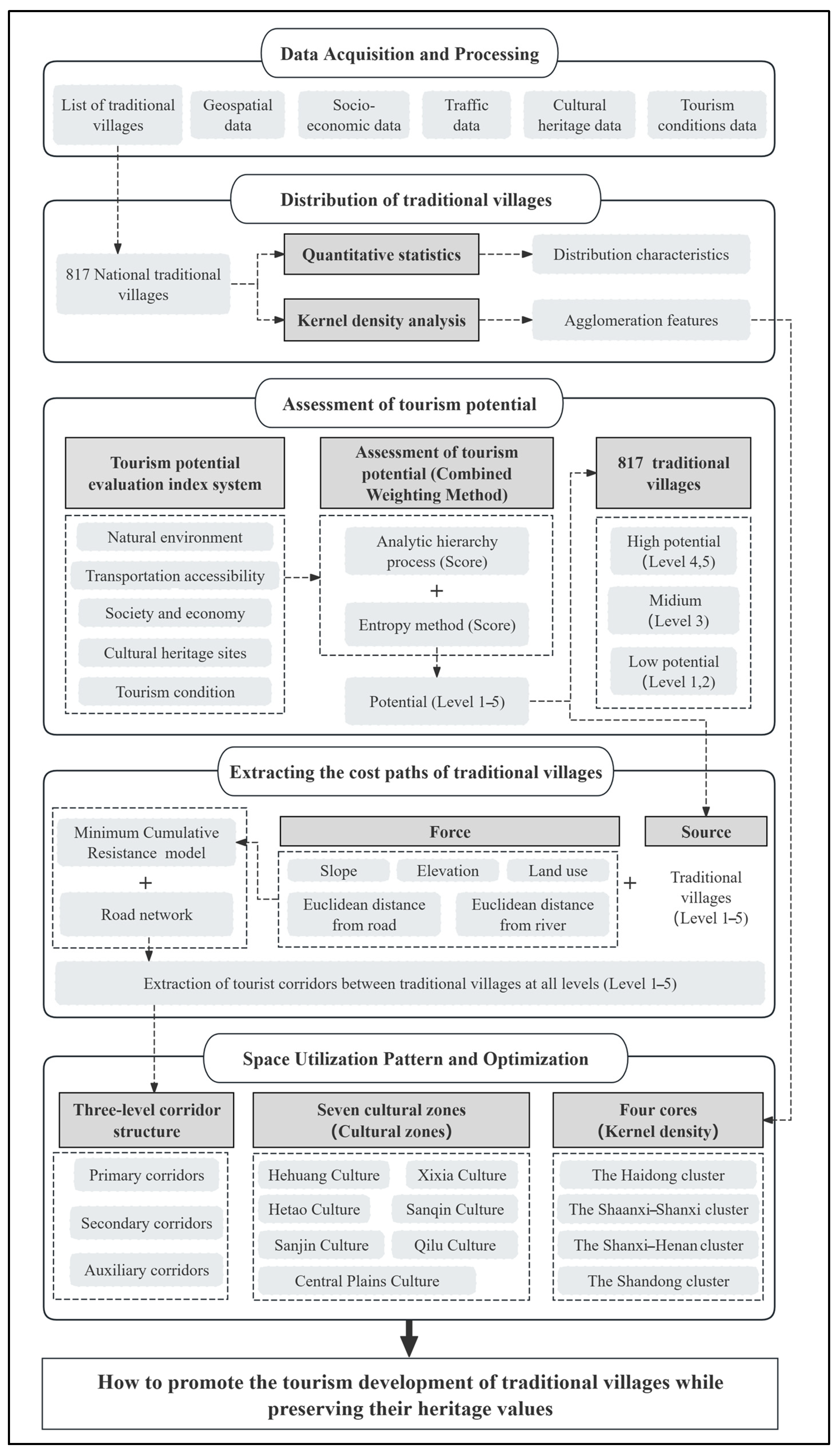
2.1. Technical Route
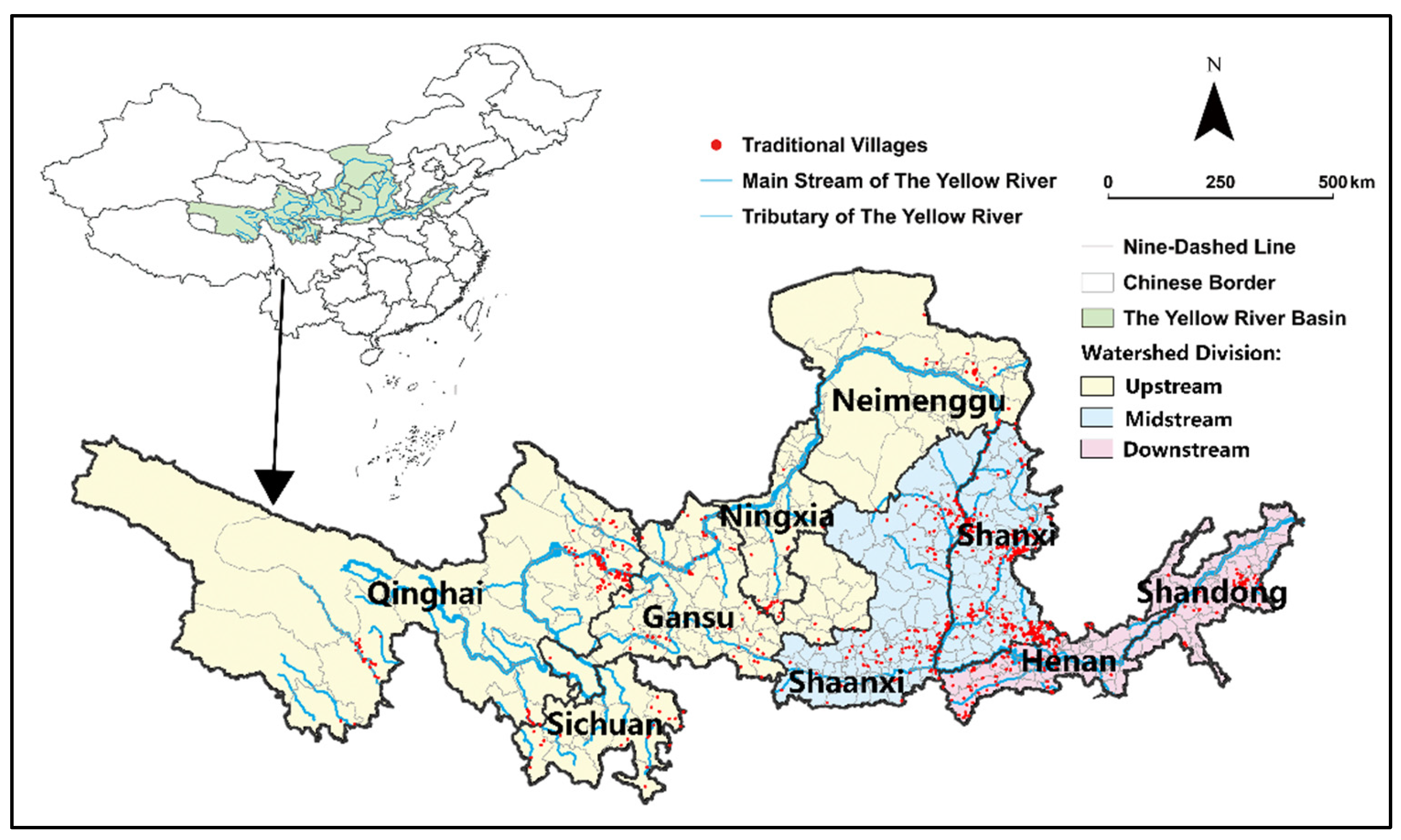
There are five main steps required for research (Figure 1).

2.2. Research Area

The Yellow River traverses nine provinces, namely Qinghai, Sichuan, Gansu, Ningxia, Inner Mongolia, Shanxi, Shaanxi, Henan, and Shandong. This designated area encompasses a total of 817 national traditional villages (Figure 2). The Yellow River Basin (YRB), acknowledged as the birthplace of Chinese civilization [30], encompasses a rich and diverse collection of cultural heritage resources. Based on its geographical features and the characteristics of the river, the YRB is traditionally categorized into three distinct regions: the upper, middle, and lower sections.
The upstream regions predominantly consist of plateaus and mountainous terrain, encompassing the provinces of Qinghai, Sichuan, Gansu, Ningxia, and Inner Mongolia. These areas are inhabited by various ethnic minorities, including the Tibetan, Hui, and Tu peoples, who have contributed to the development of significant cultural heritages such as the Hehuang civilization, the Xixia civilization, and the Hetao nomadic culture. Notably, the globally renowned Mogao Caves, a UNESCO World Heritage site, are located in upstream areas. The midstream areas, including Shaanxi and Shanxi, are characterized by a high concentration of traditional villages. Shaanxi is particularly recognized for its historical significance during the Tang Dynasty and its associated Sanqin culture, which is exemplified by landmarks such as the Great Wild Goose Pagoda, the Terracotta Army of Emperor Qin, and the cave dwellings. In Shanxi, the Sanjin culture is prevalent, with heritage sites including the Foguang Temple from the Tang Dynasty, the Yungang Grottoes, and the ancient city of Pingyao, all of which are famous [31]. The downstream is mostly plains and deltas, mainly including Henan and Shandong. The Central Plains culture dominates in Henan province, where the oracle bone script was first unearthed at the Yinxu Ruins in Anyang. Conversely, Shandong is primarily associated with Qilu culture, which is distinguished by the prominence of Taoism and Confucianism within the region [32,33].

2.3. Methods

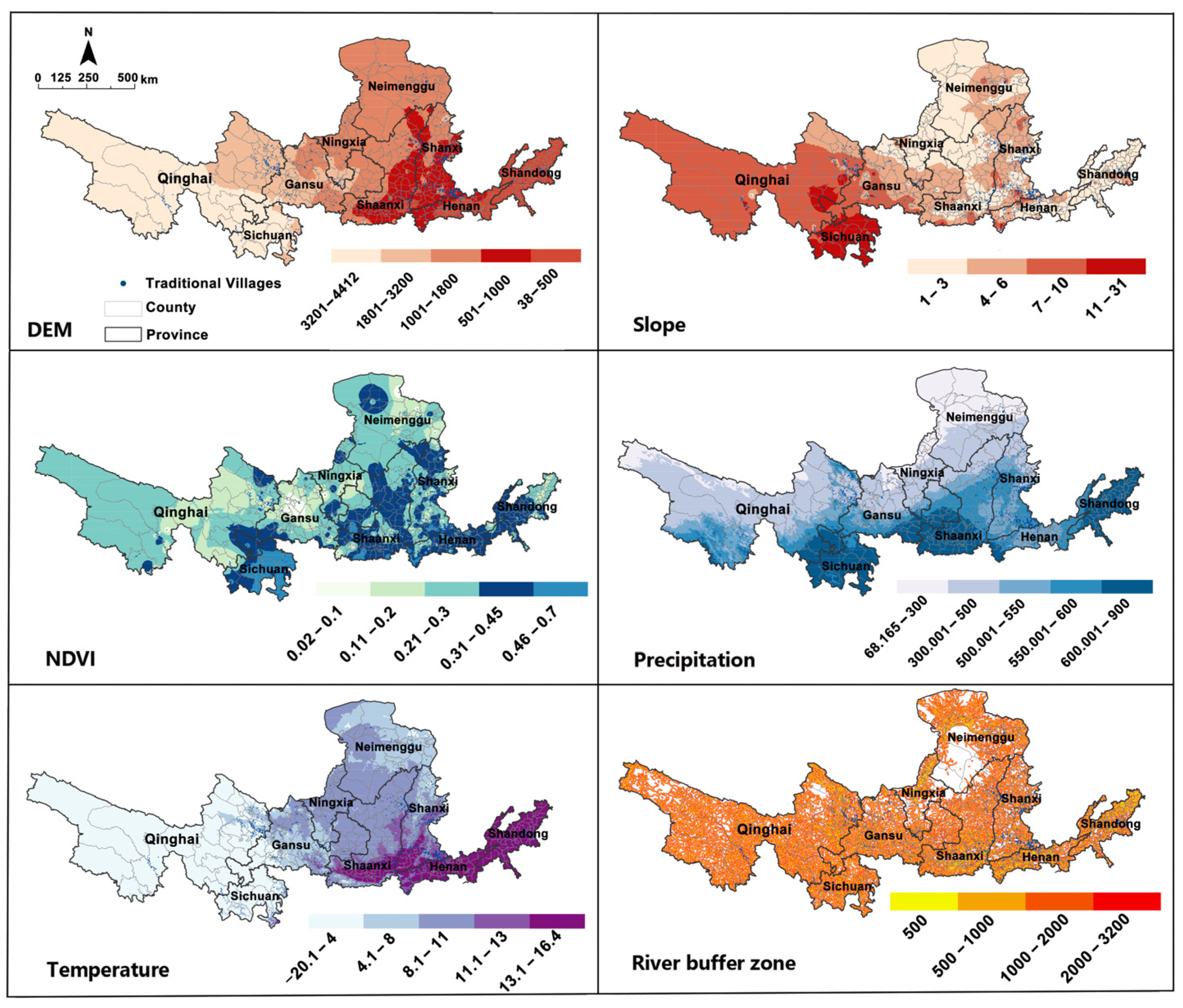
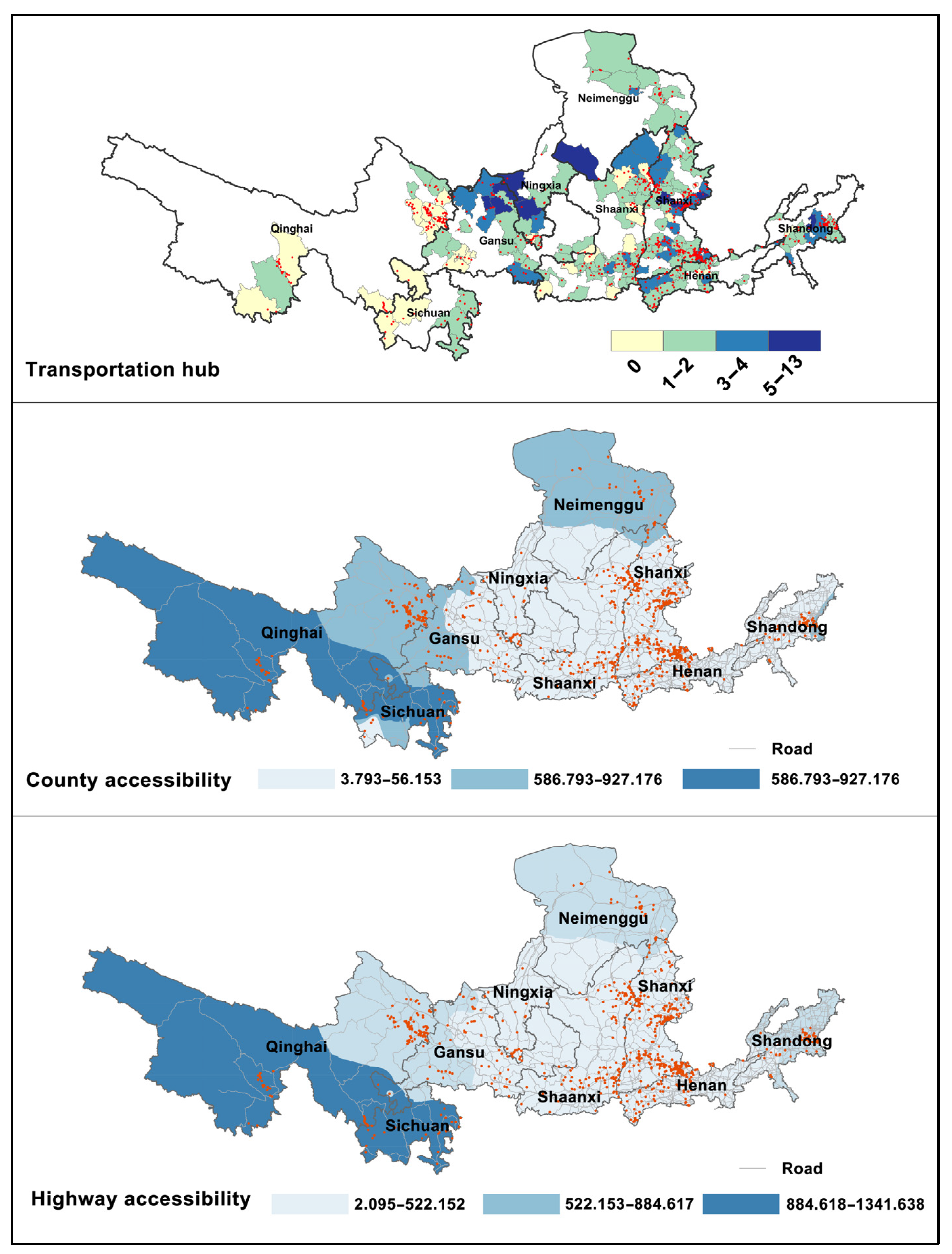
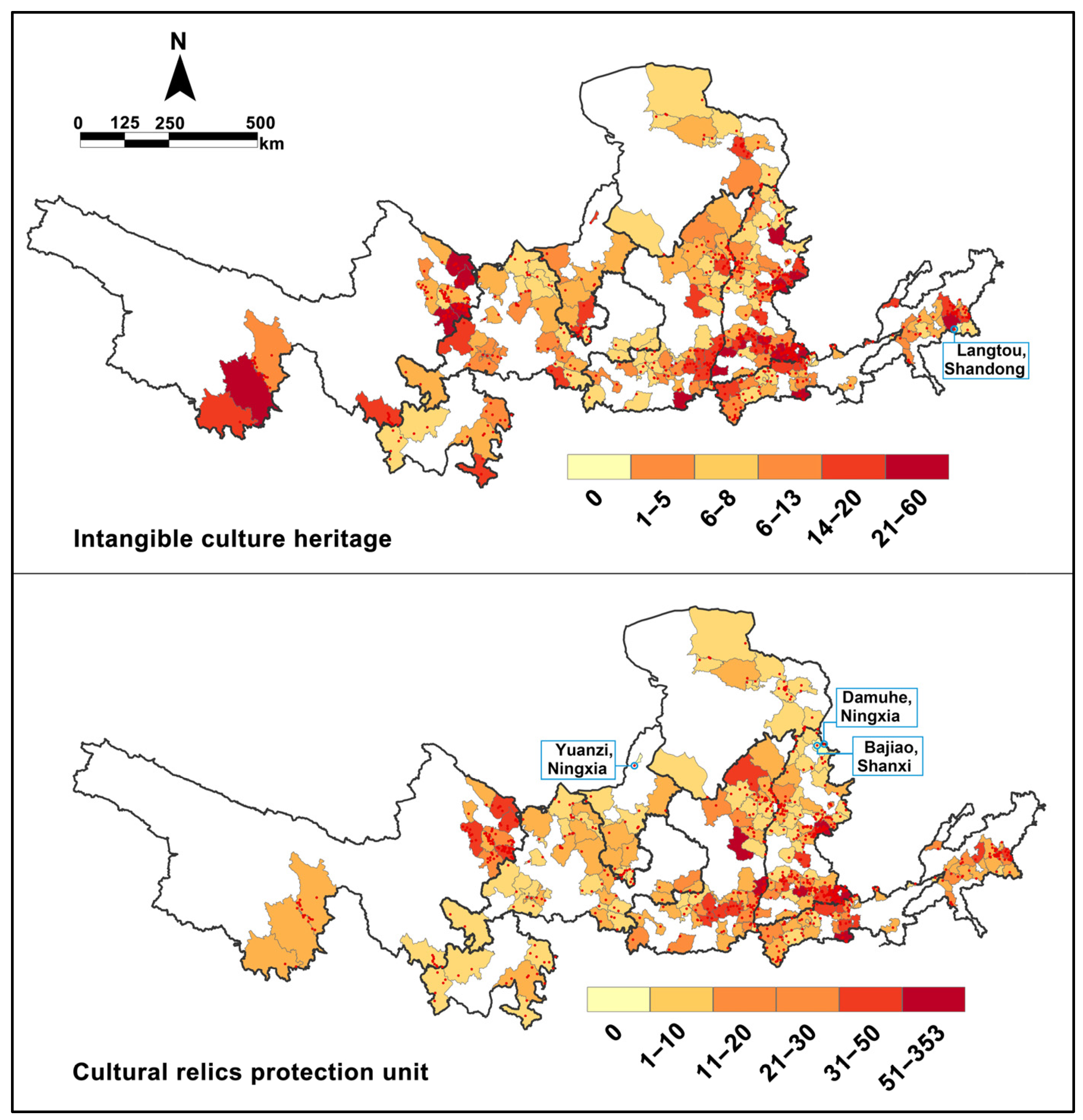
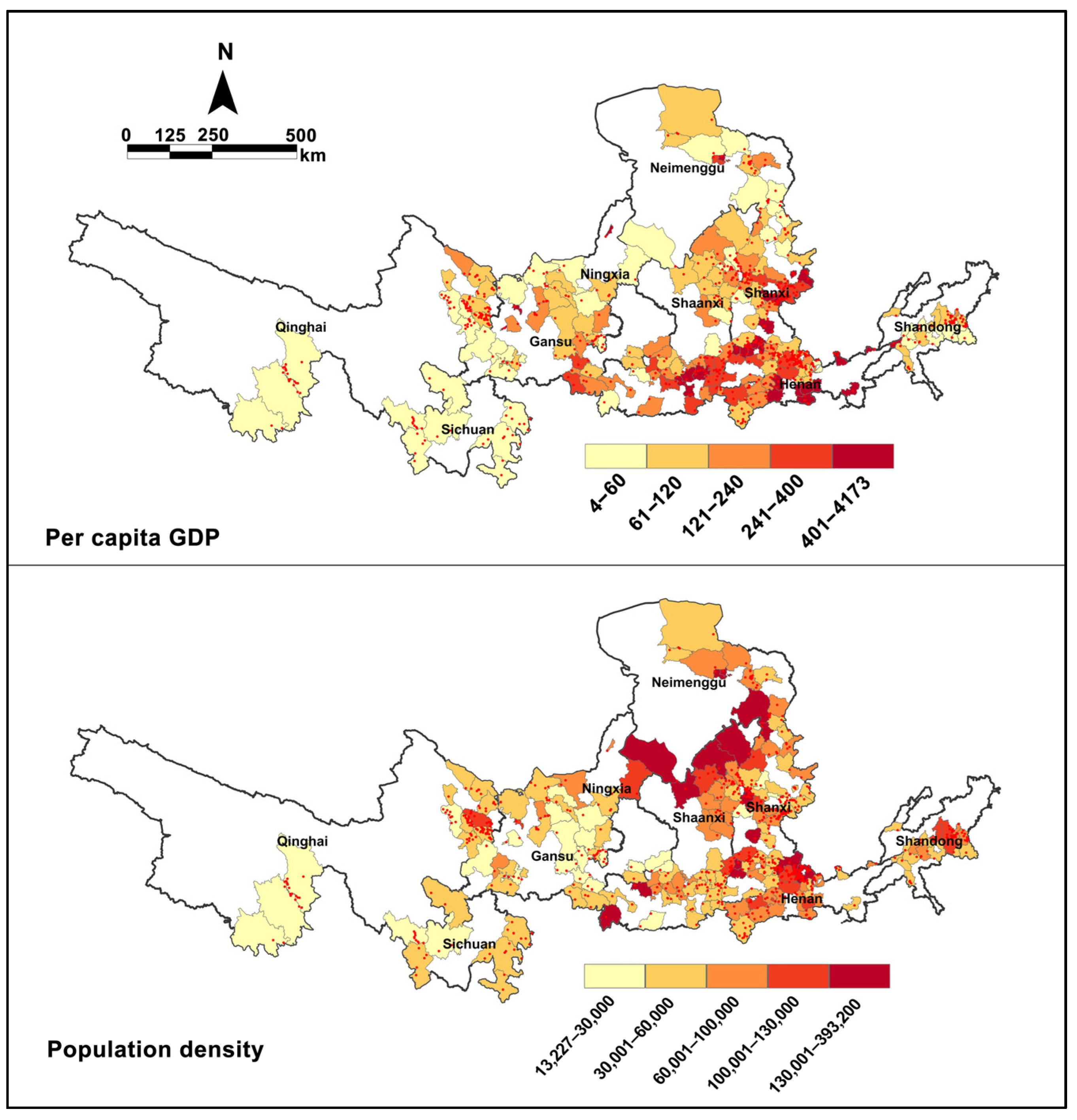
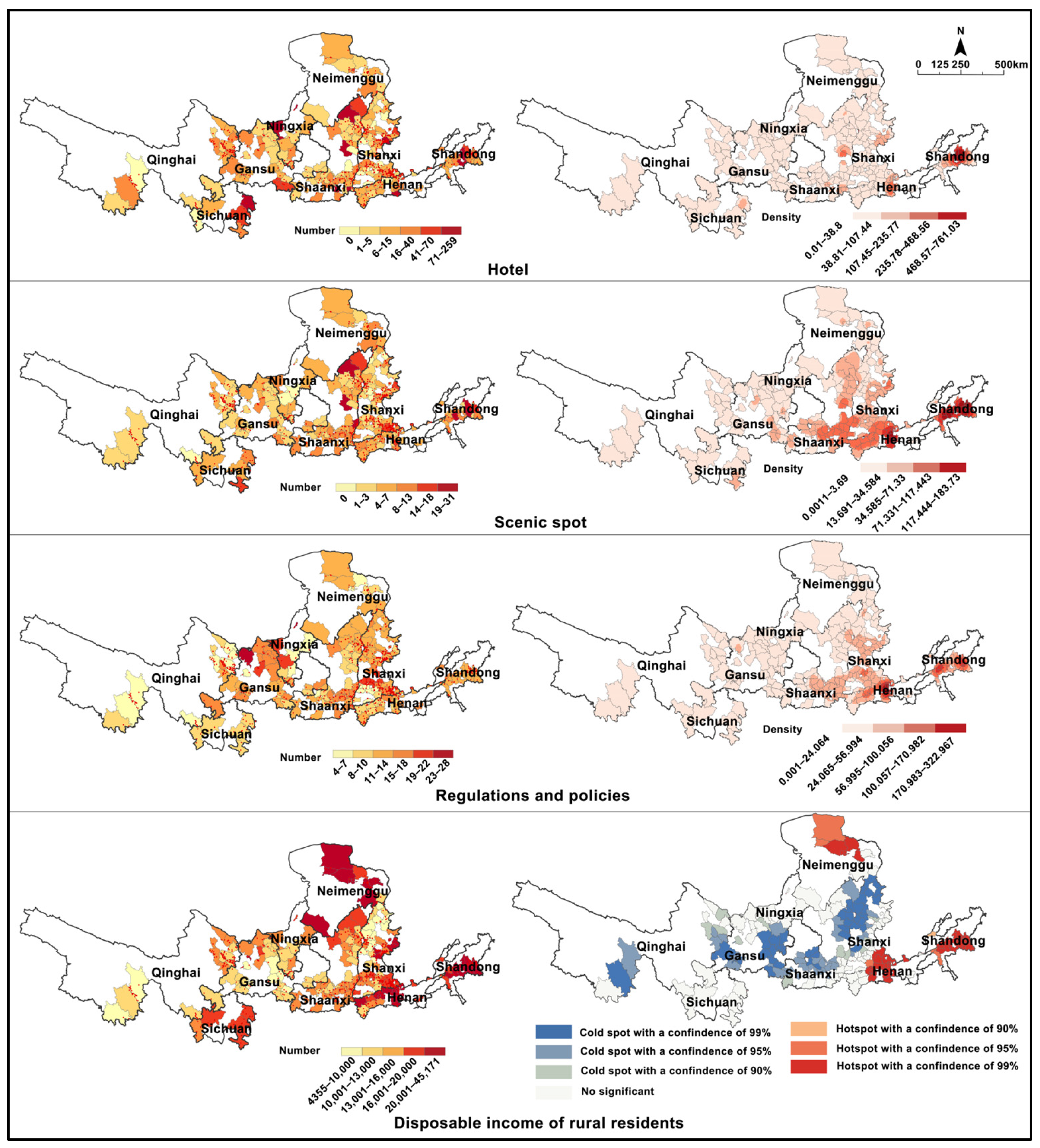
2.3.1. An Indicator System for Evaluating Tourism Potential

Drawing upon the previous studies, this paper selected 17 indicators from the five dimensions of natural environment, transportation accessibility, society and economy, cultural heritages, and tourism condition (Table 1). The majority of the index values have been classified into five distinct categories (1 to 5) utilizing a natural break segmentation methodology, with higher scores indicating a greater potential for tourism development.
The list of traditional villages is sourced from the Chinese Traditional Villages Network [34]. Their geographic coordinates are derived from the Gaode Map. The foundational data pertaining to the YRB is sourced from the National Cryosphere Desert Data Center [35]. Additionally, the national road network data, including highway entry and exit points, is obtained from the National Catalogue Service for Geographic Information [36]. Land use data is produced through visual interpretation of 2020 remote sensing imagery, which is acquired from the Resource and Environmental Science Data Platform [37], achieving a spatial resolution of 30 m. The origins of other datasets are mentioned in Table 1.

2.3.2. Combined Weight Method

The Analytic Hierarchy Process (AHP) and Entropy Weight Method (EWM) are commonly employed techniques for determining the weights of indices. AHP relies on expert judgment, which has a significant degree of subjectivity. Conversely, EWM is grounded in the variability of objective data but ignores the difference in the actual meaning of the index [38]. This study adopts a hybrid approach that integrates the weighting methodologies of AHP (1) and EWM (2) (3) to calculate the index weight, namely Combined Weighting Method (CWM) (4). This approach combines subjective and objective perspectives to evaluate the development potential of traditional village tourism, making the results more convincing.
W 1 = w j ¯ j = 1 n   w j ¯
E j = 1 ln m i = 1 n   p i j l n p i j    
W 2 = 1 E j j = 1 n   ( 1 E j )
W j = W 1 W 2 j = 1 n   W 1 W 2
W1 represents the weight value of AHP obtained by Yaahp 10.1 software, j = 1, 2, 3, … n; w j ¯ is calculated as the arithmetic square root of the average of the sums of pairwise products of the elements within each row of the corresponding matrix; W2 denotes the weight obtained from the EWM utilizing Stata 17.0 software; Ej signifies the entropy value of each index; m is the evaluation index number; pij represents the proportion of each normalized indicator value relative to the total sum of normalized values; i and j refer to the row and column indices within the judgment matrix, respectively. Wj denotes the weight associated with the CWM.

2.3.3. Minimum Cumulative Resistance

The Minimum Cumulative Resistance (MCR) model, proposed by Knappen, a Dutch ecologist [39], is utilized to determine the minimal effort or cumulative cost required for simulating various landscapes by assigning different resistance values from a designated source point [40]. This approach thoroughly considers various factors, including land use, topography, available resources, and environmental conditions. It identifies the path of minimum cumulative resistance, facilitates connectivity among cultural heritage sites, and prevents the isolated development of these sites, characterized by a small amount of data and strong visualization [41]. Currently, some scholars use this method to build cultural heritage corridors [42]. In the context of traditional village corridors, the MCR model is applied to simulate the resistance encountered by the traditional village as the “source” while it traverses horizontally across space with varying resistance values. Appropriate resistance metrics are essential, as they accurately represent the mobility challenges faced by species between traditional villages, thus facilitating the visualization of resistance surface dynamics originating from dispersal origins. Informed by established scholarly evidence [25,43,44], the study chose five factors, including elevation, slope, distance from river, land use type and European distance of road, to construct the resistance surface (Table 2).
The calculation formula is as follows:
M C R = m i n j = n i = m   D i j × R i
In this equation, Dij presents the distance between traditional village i and j, while Ri indicates the resistance factor for the traditional village i. The operation process is based on the Linkage Mapper tool in ArcGIS Pro 3.1.5.

3. Results

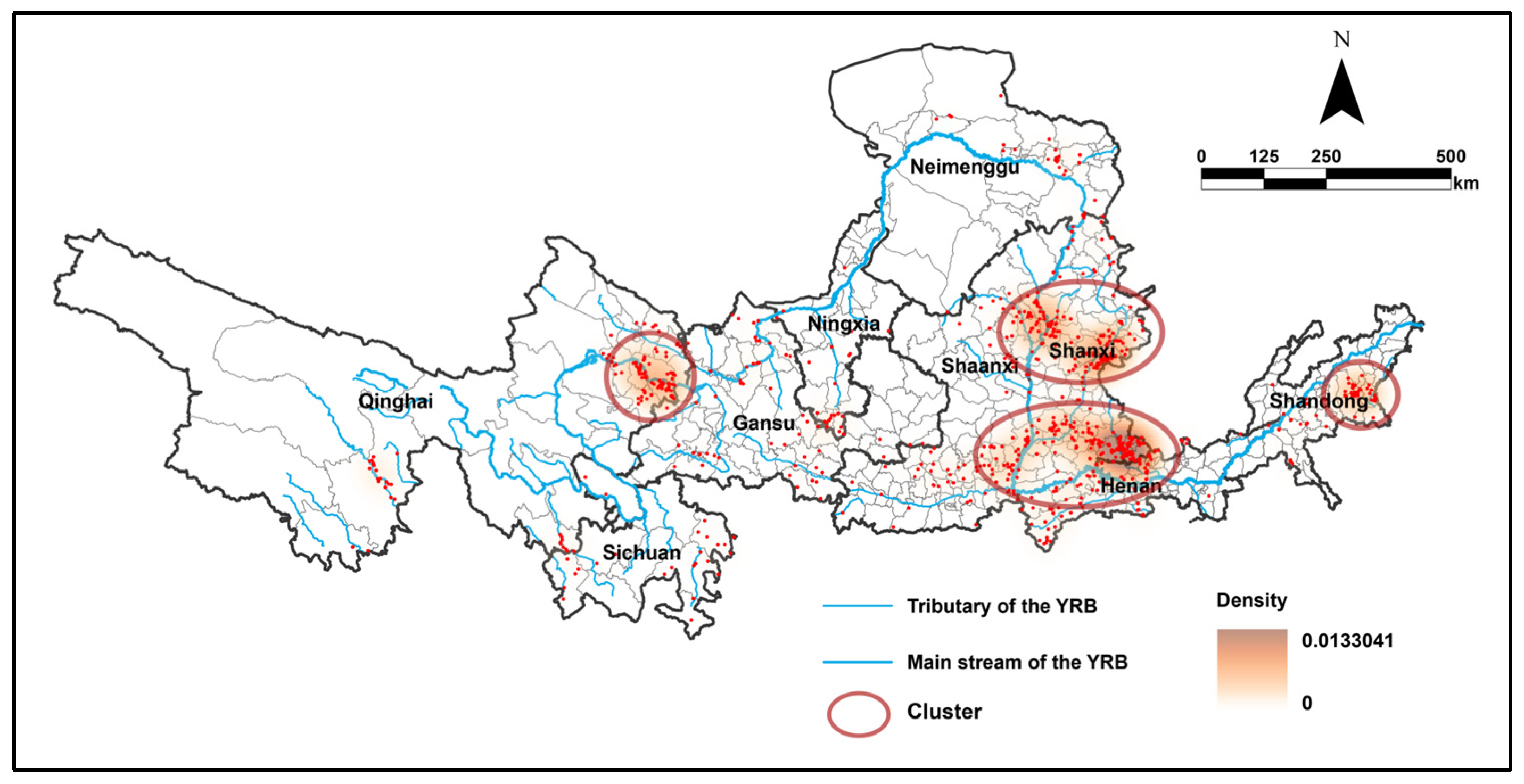
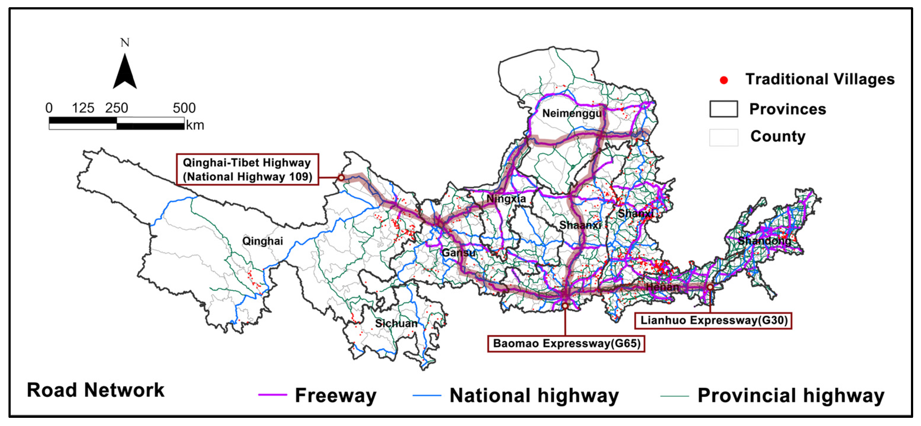
3.1. Spatial Distribution of Traditional Villages

The locational pattern of traditional villages within the YRB exhibits an uneven mode. The middle stream region contains the highest concentration of traditional villages comprising approximately 53.7% of the total, which is followed by the lower stream and upper stream regions accounting for 16.5% and 29.8%, respectively. Overall, there are four distinct clusters of traditional villages, which are primarily located in eastern Qinghai province, northern Shaanxi province, central Shanxi province, western Henan province, and central Shandong province (Figure 3). It is proven that the proportion of traditional villages within the four designated clusters is 9%, 19%, 28%, and 6% separately.

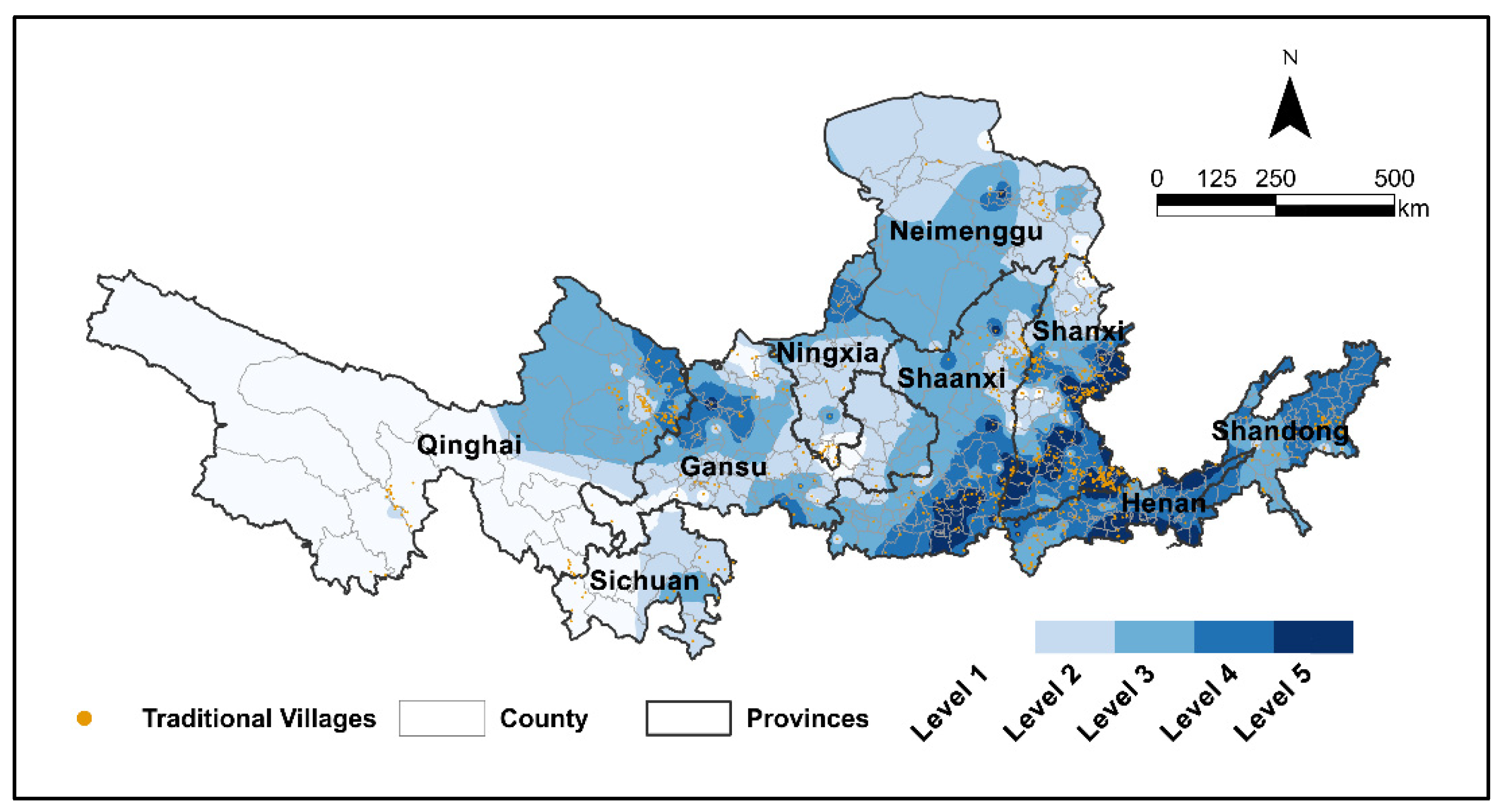
3.2. Tourism Potential Assessment of Traditional Villages

Utilizing the AHP and EWM, the weights assigned to each index have been determined (Appendix A). The findings indicate that societal and economic considerations are prioritized above all other factors, followed by cultural heritage sites, tourism conditions, and transportation accessibility. Conversely, the natural environment of traditional villages is assigned to have the lowest weight. The weights are 0.3819, 0.2902, 0.2213, 0.0718, and 0.0348, from high to low.
From the perspective of natural environment, about 56% of traditional villages are situated in low–altitude areas, while 6.3% are located at high altitude (above 3200 m). Additionally, 44.3% of the traditional villages are characterized by the presence of rivers in their vicinity, and around 52.7% exhibit a high quality of ecological landscape (Figure 4).
In general, the road networks in the YRB show a pattern characterized by a higher density in the eastern regions compared to the western areas. It is proven that the density of the road networks ranked from highest to lowest is as follows: Shandong (0.26), Henan (0.23), Shanxi (0.14), Ningxia (0.11), Shaanxi (0.10), Gansu (0.07), Inner Mongolia (0.04), Sichuan (0.03), and Qinghai (0.02). Specifically, the provinces of Henan and Shandong demonstrate a greater density and quality of road infrastructure, whereas Qinghai, Sichuan, and Inner Mongolia are marked by a comparatively sparse road network and lower quality. The Lianhuo Expressway and the Qinghai–Tibet Highway have east–west connectivity, while the Baomao Expressway provides a north–south route, collectively establishing the foundational framework of the YRB’s road network (Figure 5).
In terms of transportation accessibility, only 7.9% of traditional villages can access the nearest highway entrance within a two–hour timeframe, while 50% of these villages require more than half a day to reach the nearest highway entrance. Approximately 67.9% of traditional villages can reach the nearest county within nine hours, which remains a considerable duration. Furthermore, 20.2% of counties within the YRB lack external transportation hubs, such as railway stations, high–speed railway stations, or airports, while 36.1% of counties possess only a single external transportation hub. Overall, the transportation accessibility for traditional villages in the upper reaches of the YRB is notably inferior compared to that of villages in the middle and lower reaches, indicating a significant limitation in transportation options for these communities (Figure 6).
From the perspective of cultural heritages sites, almost all traditional villages possess significant intangible cultural heritage and cultural relics protection units, accounting for 99.88% and 99.63%, respectively, with the exceptions of Langtou in Shandong, Yuanzi in Ningxia, and Bajiao and Damuhe in Shanxi (Figure 7).
As for society and economy, the per capita GDP of 24.8% of counties with traditional villages report a per capita GDP exceeding 10,000 yuan in 2023. These counties are mainly situated in the middle and lower reaches, particularly in northern Shaanxi province and southern Inner Mongolia (Figure 8).
Regarding tourism conditions, approximately 94.7% of the villages are located near or within scenic areas. Most counties offer adequate hotel accommodation to facilitate the tourism development of traditional villages. Furthermore, this study reveals significant regional disparities in tourism conditions. The density of hotels and scenic attractions is notably higher in the middle and lower reaches of the YRB compared to the upper reaches. For instance, the average number of hotels in Shandong can reach 20, whereas Inner Mongolia has an average of only 6. Additionally, the middle and lower reaches of the YRB have implemented more comprehensive regulations and policies to promote the tourism development of traditional villages (Figure 9).
The assessment of tourism potential revealed that traditional villages classified as high–level (level 4 and 5) constitute 55.8% of the total number of traditional villages, with a predominant distribution in the provinces of Shanxi and Henan. In contrast, low–level (level 1 and 2) villages have a proportion of about 25.8%, mainly located in Qinghai (Figure 10). Overall, the tourism potential in the midstream and downstream regions is found to be greater than that in the upstream areas. Spatial cluster analysis indicates that tourism potential hotspots are concentrated in the midstream and downstream sections, whereas cold spots are located in the upstream region of the YRB (Figure 11).

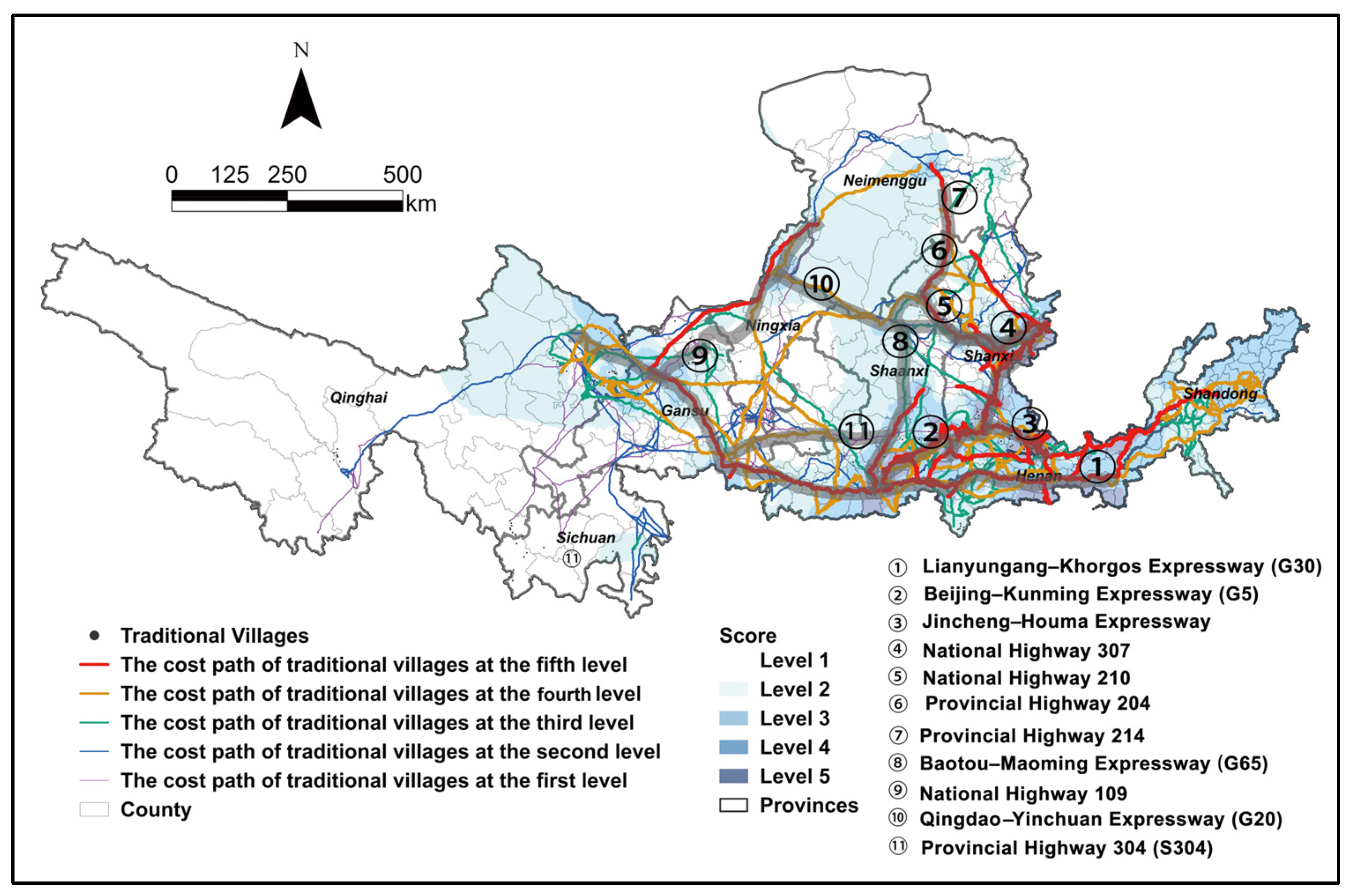
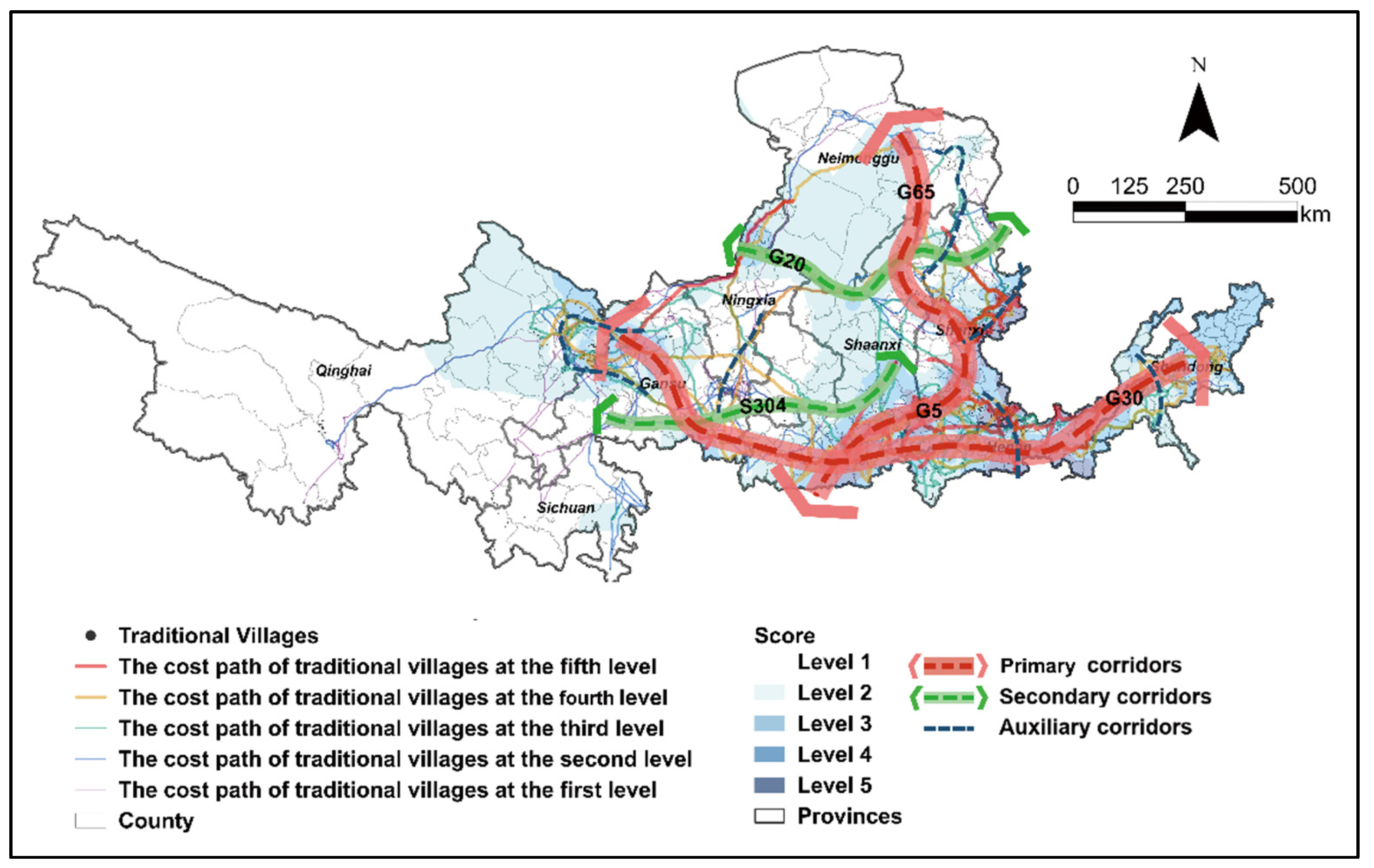
3.3. Extracting the Cost Paths of Traditional Villages with Different Tourism Potential

Utilizing traditional villages with varying levels of tourism potential as “sources”, the MCR model was employed to delineate the cost paths associated with these villages within the YRB. The paths of higher levels correspond to greater tourism potential. The primary paths with high–level (4–5) tourism potential predominantly utilize the Lianyungang–Khorgos Expressway (G30), the Beijing–Kunming Expressway (G5), the Jincheng–Houma Expressway, the national highway 307,210, and provincial highway 221,214, which collectively form the main framework for the traditional villages corridor in the YRB. Level 3 routes serve to closely connect the traditional villages and act as significant supplements to the primary corridors. Conversely, level 1 and level 2 routes are mainly distributed in Qinghai, Gansu, and Ningxia, the upper stream region, relying on G30, the Baotou–Maoming Expressway (G65), and national highway 109 (Figure 12).

4. Discussion

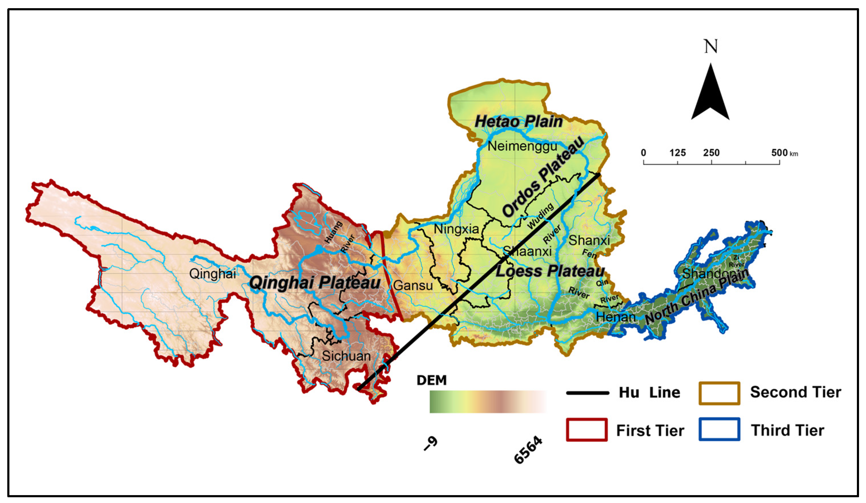
4.1. Spatial Distribution Characteristics of the Traditional Villages

The traditional villages in the YRB are predominantly situated in the eastern region, with a lesser presence in the west, and are distributed along the river’s course. This observation corroborates the findings of Huang Y and Gao C, who reported a higher level of economic development in the eastern segment of the YRB, where traditional villages are densely populated [45,46]. The spatial layout features of traditional villages in the YRB are intricately linked to the natural environmental patterns of China. The Yellow River traces various geographical regions from its upper to lower reaches, including Qinghai Plateau (a part of Tibetan Plateau), the Loess Plateau, the Ordos Plateau (a part of the Inner Mongolia Plateau), the Hetao Plain, and the North China Plain. The scarcity of traditional villages in the western YRB can be attributed to the adverse climatic and environmental conditions of the Qinghai–Tibet Plateau, which hinder human settlement and agricultural activities. The Tibetan Plateau is characterized by arid and semiarid climate zones, with rugged terrain, and serious soil and water loss. In contrast, the Guanzhong Plain and North China Plain have witnessed the emergence of numerous traditional villages, benefiting from their flat terrain, fertile soil, ample rainfall, and favorable climate [47].
In addition, the spatial distribution characteristics of traditional villages in the YRB are consistent with “Hu huanyong Line”, which was put forward by Huanyong Hu in 1935, serving as a significant geographical boundary of the Chinese population, illustrating the interplay between China’s natural environment, resource availability, and human activities. “Hu huanyong Line”, from northeast to southwest, divided China into two parts. The southeast part is characterized by more favorable natural conditions and enhanced transportation accessibility, whereas the northwest region exhibits contrasting characteristics [48]. The northwest side of the line encompasses the regions of Qinghai, Sichuan, Gansu, Ningxia, and Inner Mongolia, the upper stream of the YRB. In contrast, the southeast side covers Shaanxi, Shanxi, Henan, and Shandong, the midstream and downstream of the YRB. Notably, the southeast side of the line accounts for approximately 36% of the country’s land area, yet it is inhabited by about 94% to 96% of China’s population. The northwest region accounts for 64% of the nation’s total land area; however, it is inhabited by merely 4% to 6% of the population (Figure 13).

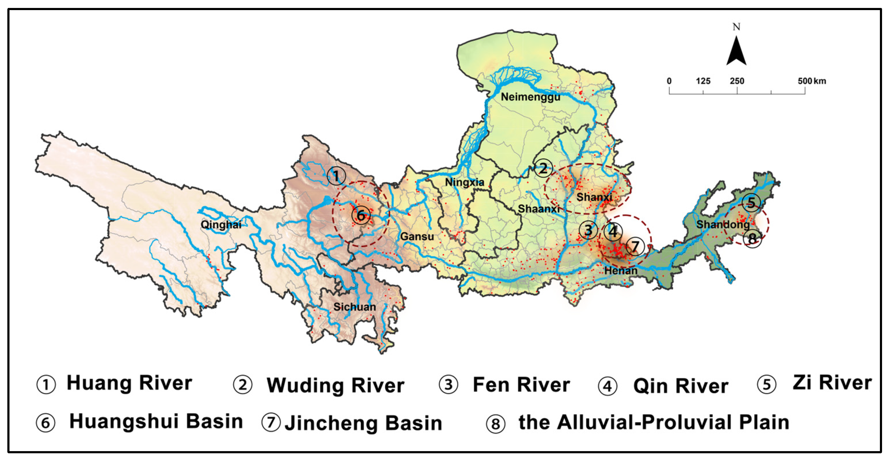
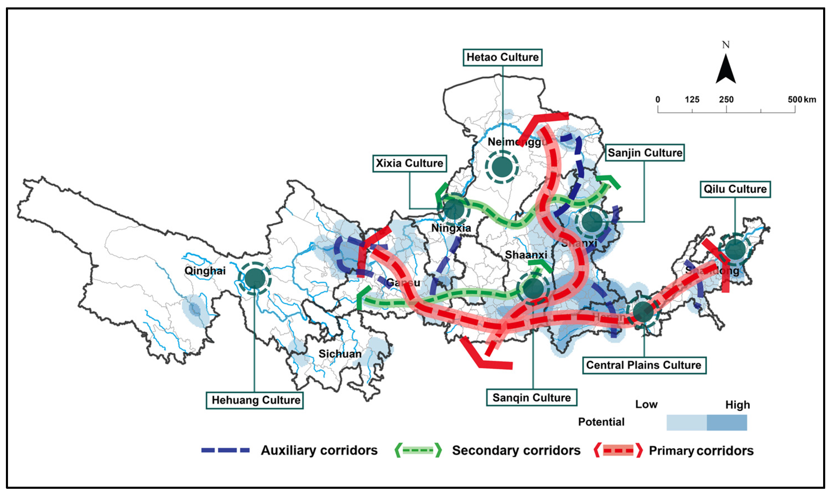
4.2. Spatial Utilization Pattern of Traditional Villages in Yellow River Basin

4.2.1. The Four Cores of Spatial Utilization Pattern

The four cores represent regions with a high concentration of traditional villages, specifically the Haidong cluster in Qinghai Province, the Shaanxi–Shanxi cluster, the Shanxi–Henan cluster, and the Shandong cluster. These clusters distribute in flat areas of river basins or plains. These areas are particularly advantageous for human habitation and agricultural production, as they offer favorable land and water resources for traditional villages. For instance, the Haidong cluster is positioned in proximity to the Huangshui Basin, while the Shaanxi–Shanxi cluster is located within Wuding River Basin and Fen River Basin. (Figure 14).

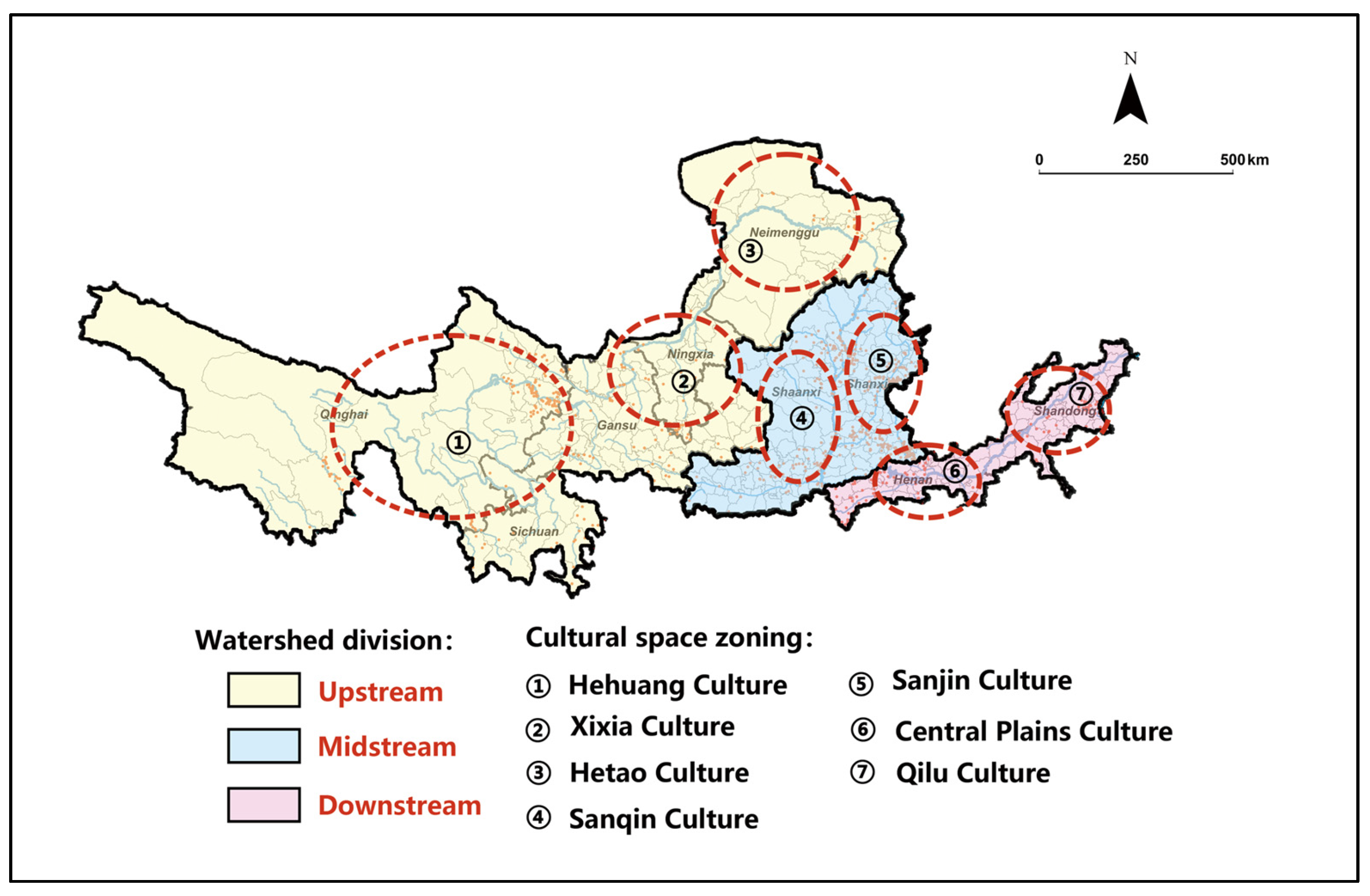
4.2.2. The Seven Cultural Zones of Spatial Utilization Pattern

In accordance with the Yellow River National Cultural Park Plan proposed in 2023, this paper delineates seven distinct cultural zones: Hehuang culture zone, Xixia culture zone, Hetao culture zone, Sanqin culture zone, Sanjin culture zone, Central plains culture zone, and Qilu culture zone (Figure 15). Each of these zones embodies unique regional cultural attributes (Table 3.).
The Hehuang cultural zone is primarily located in eastern Qinghai, where Hui, Tibetan, Tu, and Salar lived. This region is noted for its artistic creativity, particularly in rock paintings, painted pottery, murals, and other forms of visual art. Notable architectural features include mosques, robust stone watchtowers, and Salar structures that exhibit Central Asian influences [49]. The Xixia cultural zone is predominantly associated with the Tangut people. Residential structures in this area typically face south and are constructed with thick walls, primarily utilizing loess, masonry, and wood [50]. The Hetao cultural zone serves as a confluence of agricultural and nomadic civilizations, inhabited by various ethnic minorities such as the Mongolian, Hui, Daur, Evenki, and Oroqen people. The architecture in this zone reflects both nomadic and agricultural traditions, exemplified by the lightweight and easily disassembled yurt [51].
The Sanqin culture zone, where the residential buildings are famous for cave dwellings, is located in Shaanxi, [52]. The Sanjin cultural zone is unique to Shanxi. It is known for its Buddhist heritage, such as the Yungang Grottoes, Huayan Temple, and Hanging Temple [53].
The Central Plains culture zone is influenced by the philosophical concept of “Li”. The concept of “li”, also called “Etiquette”, is a kind of moral code and ethical model, emphasizing mutual respect and humility between people. The “Li” culture is an important part of Chinese civilization [54]. The Qilu cultural zone is renowned for Taoism and Confucianism. The architectural materials predominantly include black slate, blue bricks, and gray tiles, featuring both manorial structures with flying eaves and upturned corners [55].
Table 3. The cultural characteristics of the seven cultural regions.
Cultural ZoneCharacteristicsRepresented Cultural Heritage
HehuangIt exemplifies a harmonious coexistence of grassland and agricultural cultures. Multicultural environment fosters cultural exchanges, integration, and coexistence among these diverse groups. A variety of religions, such as Han Buddhism, Tibetan Buddhism, Taoism, and Islam, coexist and interweave, resulting in a rich tapestry of regional, ethnic, and religious cultures [56].
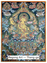
Land 14 01402 i001
XixiaLong–standing interactions among the Dangxiang, Han, Tubo, Uyghur, and other ethnic groups have been significantly shaped by the influences of Silk Road culture, as well as Central Asian and Western regional cultures. This has led to a vibrant exchange and integration of diverse cultural elements, including art, military traditions, clan structures, etiquette, and customs, with the XiXia script serving as a notable example [57].
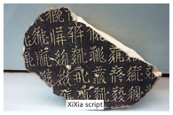
Land 14 01402 i002
HetaoThe Xiongnu, Mongolian, and other nomadic peoples have multiplied here, and have contributed to a rich array of primitive cultural artifacts. These groups have preserved their nomadic traditions of horseback riding and archery while also adopting agricultural practices, thereby integrating into the broader borderland culture characterized by cultural diversity and symbiotic relationships [58].
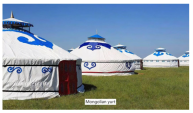
Land 14 01402 i003
SanqinTracing its origins to the Zhou and Qin dynasties, it possesses a long history marked by significant agricultural and farming cultural traits, alongside a wealth of ethnic diversity. The local customs are characterized by simplicity and vitality, with a deep cultural heritage that encompasses a variety of folk activities, including temple fairs, Shehuo, and shadow puppetry [59].Land 14 01402 i004
SanjinThe cultural lineage can be traced back to the Yao and Shun periods, showcasing a rich historical background. The Buddhist culture of northern Shanxi, the merchant culture of Jin in central Shanxi, and the root–seeking culture of southern Shanxi collectively contribute to a diverse Shanxi culture, characterized by its inclusivity [60].
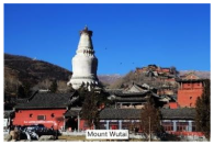
Land 14 01402 i005
Central PlainsAs a crucial cradle of Chinese civilization, it boasts profound historical and cultural deposits, which exhibit unique cultural characteristics and a tradition of inclusivity. It has also demonstrated remarkable capabilities in scientific and technological innovation, being the origin of all four of the Great Inventions of ancient China [61].
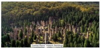
Land 14 01402 i006
QiluThe culture is prominently represented by “rites and music culture” and “etiquette culture”, resulting from the organic integration of Western Zhou culture, Dongyi culture, Confucian thought, and Taoist thought. This synthesis has given rise to a cultural system centered on Confucianism, which emphasizes the importance of ritual and music education, family ethics, and clan systems, while also highlighting the hierarchical distinctions of seniority and junior status, as well as the concept of the unity of family and state [32]. Land 14 01402 i007

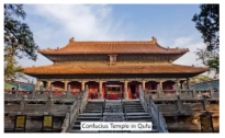
4.2.3. The Multiple Corridors of Spatial Utilization Pattern

Utilizing the results from the tourism potential assessment and the MCR model, this paper has established a three–level system consisting of primary, secondary, and auxiliary corridors. Two primary corridors have been identified, linking traditional villages with high tourism potential. The first primary corridor was an east–west horizontal corridor, relaying on the G30 Expressway. The second primary corridor extends from Shanxi to Inner Mongolia, creating a south–north vertical corridor that predominantly relies on the G5 and G65 Expressways. There are two secondary corridors. The first originates in central Shaanxi and extends to Gansu, primarily relying on provincial highway 304 (S304). The other links northern Ningxia, Shaanxi, and Northern Shanxi, predominantly relying on the Qingdao–Yinchuan Expressway (G20). In addition, six auxiliary corridors have been established, each connecting various traditional villages within specific regional contexts (Figure 16).
Finally, the paper advocates for a spatial utilization framework characterized by “four cores, seven cultural zones, and multiple corridors” to enhance the tourism prosperity of traditional villages within the YRB (Figure 17).
The spatial utilization pattern for traditional villages in the Yellow River Basin as presented in this research represents an innovative approach to the sustainable preservation and development of these traditional villages, extending from the individual to the regional scale. It not only takes the tourism development potential of each traditional village into account at the micro level, but also simultaneously addresses the preservation of cultural heritage, the development of traditional villages, and the exchange between cultures at the macro level, providing guidance for policymakers to develop strategies for the protection of traditional villages within the YRB.
At the same time, it provides a reference for the protection of cultural heritage in the other great river basin. Specifically, it considers natural, economic, cultural, transportation, and other factors, offering universal evaluation indicators and frameworks for assessing the potential for tourism development. It also provides a new way for the systematic protection of regional cultural heritage, that is to connect the dispersive cultural heritage on a larger scale through heritage corridors. Additionally, the strategies of cultural zoning and differentiation mentioned in this paper also provide ideas for the protection of cultural heritage in other similar cross–cultural regions.

4.3. Limitation

Primarily, the study focused exclusively on static factors, neglecting the potential dynamic changes associated with these variables. For example, severe weather conditions, including intense rainfall, elevated temperatures, substantial snowfall, and other adverse meteorological phenomena, are likely to heighten both the risks and expenses associated with travel. These conditions may also diminish the overall comfort of travel experiences, consequently leading to a decline in travel activities. Furthermore, significant population movements within traditional villages, such as the mass migration of residents, can result in a diminished labor force. This phenomenon may disrupt cultural transmission, adversely impacting the development of tourism resources and the quality of services offered, forming a negative feedback loop that impedes the advancement of tourism. Concurrently, while the resistance factors we have identified are commonly utilized in the formulation of a resistance surface, it is needed that the significance of their impact on tourism development be subjected to further empirical examination. Additionally, the data collection process was time–consuming because a unified and complete system for the data monitoring of traditional villages has not been formed.
In the future, with the advancement of big data, other data acquisition methods are worth exploring. Also, the creation of a dynamic evaluation platform is necessary in the future, which not only collects the data of trajectories and preferences of diverse demographic groups but also facilitates the assessment of both the short–term development and long–term impacts of traditional villages to adjust the ongoing refinement of tourism development strategies, and contribute positively to the development of corridors and overall tourism growth. Of course, the evaluation indexes of the platform also need to be further considered.
Additionally, it is advised for future research to incorporate remote sensing data over a period to develop a dynamic evolution model for the evolution of the natural environment within the Yellow River Basin and evaluate the resilience of heritage corridors in the context of environmental change scenarios to identify more precise tourism development corridors. Similarly, the opinions of stakeholders such as residents and tourists should be included to better plan the construction of tourism corridors.

5. Conclusions

This paper proposes a sustainable spatial utilization pattern for traditional villages in the YRB. The proposed spatial utilization pattern of “four cores, seven cultural zones, and a three–level corridor system” was built based on the tourism potential assessment and heritage corridors analysis. Some obvious findings were shown in this paper.
Firstly, the distribution pattern of traditional villages within the YRB exhibits a pattern characterized by a higher concentration in the middle and lower stream regions compared to the upper stream regions, mainly distributed in Henan, Shanxi, and Shaanxi provinces. This analysis identifies four clusters of traditional villages—Haidong, Shaanxi–Shanxi, Shanxi–Henan, and Shandong—primarily situated in flat terrains and plains. This spatial distribution aligns with the “Huanyong Hu” Line, which reflects the natural environment, population density, and agricultural development across China.
Secondly, this paper divided the YRB into seven distinct cultural zones, Hehuang culture zone, Xixia culture zone, Hetao culture zone, Sanqin culture zone, Sanjin culture zone, Central plains culture zone, and Qilu culture zone. The culture zone generally has relatively consistent ethnic cultures, customs, and architectural forms.
Thirdly, about 55.8% of the traditional villages exhibit high tourism potential, particularly concentrated in Shanxi and Henan provinces, which are characterized by abundant cultural resources, accessible transportation, and robust regional economic activity.
Employing the MCR model, this study categorizes traditional villages based on varying levels of tourism potential as “sources” and delineates five levels of cost paths. The routes with high tourism potential predominantly align with national high–speed transportation networks, such as the Lianyungang–Khorgos Expressway (G30) and the Beijing–Kunming Expressway (G5). The results of MCR establish a foundational framework for traditional village corridors within the YRB. A three–tiered corridor system—comprising primary, secondary, and auxiliary corridors—has been established. The two primary corridors connect the traditional villages with high tourism potential, spanning the north–south and east–west areas of the YRB. The two secondary corridors connect areas of medium and low potential to the main corridors, while six auxiliary corridors facilitate connections between isolated potential areas and both primary and secondary corridors. Ultimately, a utilization model characterized by “four cores, seven cultural zones, and three–level corridors” has been proposed.
For policymakers, it is necessary to establish a cross–regional coordination mechanism and develop a cohesive policy strategy to promote the resource integration and coordinated development of traditional villages. Building upon the framework of “four cores, seven districts, and three–level corridors”, priority should be accorded to the advancement of traditional village tourism within the core areas. This entails concentrating resources to enhance comprehensive service capabilities and to deepen cultural experiences. Furthermore, it is essential to ensure the connectivity of the corridors and to facilitate access along the primary roadways (such as G30, G5, G65, etc.) that link the two main corridors associated with high–potential villages. Concurrently, villages situated along these corridors should enhance their tourism infrastructure and augment their cultural display functions. Secondary and auxiliary corridors should prioritize the improvement of road facilities and the enhancement of traffic accessibility. In addressing the diverse cultural zones, it is crucial to take into account the unique cultural characteristics and resource endowments of each area, thereby formulating tailored development strategies and cultural protection standards. Moreover, in the future, the enhancement of road infrastructure in the western region of the Yellow River Basin, along with the expansion of transportation corridors, is expected to facilitate the connectivity of an increasing number of diverse traditional villages.
There is no doubt that the protection and development of traditional villages necessitates the creation of differentiated strategies. For villages with high potential, it is advisable to cultivate tourism models that reflect their unique cultural identities. For instance, villages characterized by distinct cultural traits may engage in tourism activities such as live performances and folk customs experiences, with the aim of establishing a multifaceted tourist destination that integrates cultural heritage, ecological sustainability, and commercial development. However, it is vital to avoid over commercialization and the superficiality of “cultural performances”, which could compromise the authenticity of traditional villages. In contrast, for villages with lower potential, the primary focus should be on safeguarding their cultural values, while also enhancing infrastructure development. Additionally, efforts should be made to attract visitors from surrounding high–potential villages to broaden their influence. By integrating tourism potential analysis with the construction of traditional village corridors, this research offers a novel perspective on the protection and utilization of traditional villages, thereby assisting policymakers and planners in optimizing resource allocation and achieving a balanced development of regional traditional villages.
Nevertheless, this paper has some limitations. Primarily, the study focused exclusively on static factors, neglecting the potential dynamic changes associated with these variables. Additionally, the data collection process was time–consuming. With the integration of big data and other advanced technologies for real–time monitoring, other data acquisition methods are worth exploring in the future. Furthermore, the recommendations provided in the study remain largely general and do not address specific regional contexts.

Author Contributions

Conceptualization, X.L., T.W., and H.Y.; Methodology, X.L., T.W., and H.Y.; Software, X.L.; Validation, X.L.; Formal analysis, X.L.; Investigation, X.L., T.W., and Z.X.; Resources, X.L., T.W., and Z.X.; Data curation, X.L. and Z.X.; Writing—original draft, X.L. and T.W.; Writing—review and editing, X.L. and W.Y.; Project administration, W.Y. and H.Y.; Funding acquisition, H.Y. All authors have read and agreed to the published version of the manuscript.

Funding

This paper is funded by the Social Science Foundation of Shaanxi Province (No.2023J038), the Basic Scientific research operating expenses of Northwest A&F University (No. Z1090324083) and the Innovation Project for College Students (No. XN2025024025).

Data Availability Statement

The raw data supporting the conclusions of this article will be made available by the authors on request.

Conflicts of Interest

The authors declare no conflicts of interest.

Abbreviations

The following abbreviations are used in this manuscript:
MDPIMultidisciplinary Digital Publishing Institute
DOAJDirectory of Open Access Journals
TLAThree Letter Acronyms
LDLinear Dichroism
YRBYellow River Basin
CWMCombined Weighting Method
AHPAnalytic Hierarchy Process
EWMEntropy Weight Method
MCRMinimum Cumulative Resistance

Appendix A

The indicator weights and the five–level classification table obtained based on combined weighting method are as follows.
Table A1. Indicator weighting and five–level classification table.
AspectIndicatorsWeightClassification
Natural environmentSlope0.0014 Below 3° = 5; 3–6° = 4; 6–10° = 3; Above 10° = 2
Elevation0.0017 Up to 500 m = 5; 500–1000 m = 4; 1000–2000 m = 3; 2000–3200 m = 2; Above 3200 m = 1
Distance from river0.0069 500–1000 m = 5; Below 500 m = 4; 1000–1800 m = 3; 1800–3200 m = 2; Above 3200 m = 1
Average temperature0.0056 11–13° C = 5; Above 13 °C = 4; 8–11 °C = 3; 4–8 °C = 2; Below 4 °C = 1
Precipitation0.0152 300–550 mm = 5; 500–550 mm = 4; Above 550–600 mm = 3; 600–900 mm = 2; Below 300 or Above 900 mm = 1
NDVI0.0040 0.3–0.45 = 5; 0.45–0.7 = 4; 0.2–0.3 = 3; 0.1–0.2 = 2;
Transportation accessibilityNumber of railway stations, high–speed railway stations, airports0.0577 4 or More = 5; 2–4 = 4; 0–2 = 3; 0 = 0
Travel time to the nearest highway entrance0.0032 Up to 2 h = 5; 1–7 h = 4; 7–9 h = 3; 9–12 h = 2; More than 12 h = 1
Travel time to the nearest county0.0109 Up to 2 h = 5; 1–7 h = 4; 7–9 h = 3; 9–12 h = 2; More than 12 h = 1
Society and economyGDP per capita0.1003 Over ¥130,000 = 5; ¥100,000~130,000 = 4;¥60,000~100,000 = 3; ¥30,000~60,000 = 2;Below ¥30,000 = 1
Population density0.2818 400 persons/km2 = 5; 240~400 persons/km2 = 4; 120~240 persons/km2 = 3; 60~120 persons/km2 = 2; Below 60 persons/km2 = 1
Cultural heritage sitesNumber of national and provincial–level cultural relics protection units in the county0.2439 50 Points and Above = 5; 30–50 Points = 4; 20–30 Points = 3; 10–20 Points = 2; 1–10 Points = 1 (2 points each at the national level and 1 point at the provincial level)
Number of national and provincial–level intangible cultural heritages in the county0.0463 20 Points and Above = 5; 13–20 Points = 4; 8–13 Points = 3; 5–8 Points = 2; 1–5 Points = 1 (2 points each at national level, 1 point at provincial level)
Tourism conditionNumber of hotels above three – star in the county0.1256 70 Points and Above = 5; 40–70 Points = 4; 15–40 Points = 3; 5–15 Points = 2; 0–5 Points = 1 (3 points per 5–star, 2 points per 4–star, 1 point per 3–star)
Number of regulations and policies related to cultural tourism at city and county levels0.0172 18 Points and Above = 5; 14–18 Points = 4; 10–14 Points = 3; 7–10 Points = 2; Up to 7 Points = 1 (2 points per municipality, 1 point per province)
Disposable income of rural residents in counties0.0367 ¥20,000 or More = 5; ¥16,000–¥20,000 = 4;¥13,000–¥16,000 = 3; ¥10,000–¥13,000 = 2; Under ¥10,000 = 1
Number of scenic spots above 3A in the county0.0418 18 Points and Above = 5; 12–18 points = 4; 7–12 Points = 3; 3–7 Points = 2; 3 Points or less = 1 (1 point per 3A, 2 Points per 4A, 3 points per 5A)

References

  1. Housing and Urban-Rural Development Ministry, Culture Ministry, National Cultural Heritage Administration, Ministry of Finance. Notice on the Survey of Traditional Villages. Available online: https://www.mohurd.gov.cn/gongkai/zc/wjk/art/2012/art_17339_209619.html (accessed on 10 October 2024).
  2. Cai, H.; Yu, J.; Guo, Y. Spatial and temporal distribution and evolution of traditional villages in Xin’an River Basin of China based on geographic detection and remote sensing technology. Ecol. Indic. 2025, 171, 113239. [Google Scholar] [CrossRef]
  3. Zhao, X.; Xue, P.; Wang, F.; Qin, Y.; Duan, X.; Yang, Z. How to become one? The modern bond of traditional villages in centralized contiguous protection and utilization areas in China. Habitat Int. 2024, 145, 103018. [Google Scholar] [CrossRef]
  4. Flink, C.H.; Searns, R.M. Greenways: A Guide to Planning, Design and Development; Island Press: Washington, DC, USA, 1993. [Google Scholar]
  5. President’s Commission on Americans Outdoors. Americans Outdoors: The Legacy, the Challenge, with Case Studies; Island Press: Washington, DC, USA, 1987; p. 209.
  6. Conzen, M.P.; Wulfestieg, B.M. Metropolitan Chicago’s Regional Cultural Park: Assessing the Development of the Illinois & Michigan Canal National Heritage Corridor. J. Geogr. 2001, 100, 111–117. [Google Scholar]
  7. Wantzen, K.M.; Schmitt, L.; Wirbelauer, E. The Rhine—An Important Biocultural Axis for Europe. In River Culture—Life as a Dance to the Rhythm of the Waters; Wantzen, K.M., Ed.; UNESCO: Paris, France, 2022; pp. 561–587. [Google Scholar]
  8. Murray, M. The cultural heritage of pilgrim itineraries: The Camino de Santiago. Journeys 2014, 15, 65–85. [Google Scholar] [CrossRef]
  9. Yang, P.; Lu, Y.; Yang, D.; Ren, Z. Protection and activation of cultural heritage from the perspective of heritage corridors: A case study of the Dazhangxi Corridor (Fuzhou section). Planner 2024, 40, 123–130. [Google Scholar]
  10. Chong, Z. Profound Evaluation and Rediscovery of the Heritage Corridor: Historical Geographical Pre-Exploration and Analysis of Linear Historical Landscape in Japan. Landsc. Archit. 2021, 28, 10–14. [Google Scholar]
  11. Sok, S.; Nguonphan, P.; Hem, T. Cultural Corridor and Heritage Tourism Development in Cambodia. In The Palgrave Handbook of Global Social Change; Springer International Publishing: Cham, Switzerland, 2023; pp. 1–18. [Google Scholar]
  12. Kashid, M.; Ghosh, S.; Narkhede, P. A Conceptual Model for Heritage Tourism Corridors in the Marathwada Region. In Proceedings of the National Online Conference on Planning, Design and Management, Pune, India, 6–7 May 2022; pp. 6–7. [Google Scholar]
  13. Yan, L.; Gao, B.W.; Zhang, M. A mathematical model for tourism potential assessment. Tour. Manag. 2017, 63, 355–365. [Google Scholar] [CrossRef]
  14. Shohan, R.; Toleuuly, A.; Assadova, Z.K. Tourist potential and prospects of tourism industry of Kazakhstan. Educ. Sci. Without Bord. 2012, 3, 34. [Google Scholar]
  15. Loren-Méndez, M.; Maes, J.; Pinzón-Ayala, D.; Alonso-Jiménez, R.F. Accessibility to heritage knowledge: Emerging modern heritage and cultural tourism roads and infrastructures as cultural corridors. In Handbook on Heritage, Sustainable Tourism and Digital Media; Edward Elgar Publishing: Cheltenham, UK, 2022; pp. 98–106. [Google Scholar]
  16. Hua, Z.; Jamaludin, O.; Ing, D.S. A review on traditional villages protection and development in China. Construction 2024, 4, 140–149. [Google Scholar] [CrossRef]
  17. Puška, A.; Pamucar, D.; Stojanović, I.; Cavallaro, F.; Kaklauskas, A.; Mardani, A. Examination of the Sustainable Rural Tourism Potential of the Br? ko District of Bosnia and Herzegovina Using a Fuzzy Approach Based on Group Decision Making. Sustainability 2021, 13, 583. [Google Scholar] [CrossRef]
  18. Sobhani, P.; Esmaeilzadeh, H.; Sadeghi, S.M.M.; Wolf, I.D. Land potential for ecotourism development and assessing landscape ecology in areas on protection of Iran. Environ. Dev. Sustain. 2024, 26, 8103–8137. [Google Scholar] [CrossRef]
  19. Huang, H.; Miao, H.; Wang, Y. Evaluation research on the tourism development potential of traditional villages in Northwest China. J. Geogr. Sci. Dev. 2021, 40, 106–110+117. [Google Scholar]
  20. Aytuğ, H.K.; Mikaeili, M. Evaluation of Hopa’s rural tourism potential in the context of European Union tourism policy. Procedia Environ. Sci. 2017, 37, 234–245. [Google Scholar] [CrossRef]
  21. Xie, Z.; Song, J.; Zhang, H.; Wang, Y. Comprehensive evaluation of tourism development potential of cultural landscape in Fenhe River Basin. J. Desert Res. 2024, 44, 184–192. [Google Scholar]
  22. Zhan, Y.; Zhang, Y.; Zhang, J.; Xu, J.; Chen, H.; Liu, G.; Wan, Z. Risk assessment of land subsidence in Shanghai municipality based on AHP and EWM. Sci. Rep. 2025, 15, 7339. [Google Scholar] [CrossRef]
  23. Yin, L.J.; Yi, J.; Lin, Y.; Lin, D.; Wei, B.; Zheng, Y.; Peng, H. Evaluation of green mine construction level in Tibet based on entropy method and TOPSIS. Resour. Policy 2024, 88, 104491. [Google Scholar] [CrossRef]
  24. Nie, X.; Xie, Y.; Xie, X.; Zheng, L. The characteristics and influencing factors of the spatial distribution of intangible cultural heritage in the Yellow River Basin of China. Herit. Sci. 2022, 10, 121. [Google Scholar] [CrossRef]
  25. Li, W.; Jiao, J.; Qi, J.; Ma, Y. The spatial and temporal differentiation characteristics of cultural heritage in the Yellow River Basin. PLoS ONE 2022, 17, e0268921. [Google Scholar] [CrossRef]
  26. Zhang, H.; Wang, Y.; Qi, Y.; Chen, S.; Zhang, Z. Assessment of Yellow River region cultural heritage value and corridor construction across urban scales: A case study in Shaanxi, China. Sustainability 2024, 16, 1004. [Google Scholar] [CrossRef]
  27. Yang, X.W.; Wei, G.; Liang, C.; Yang, Z.; Fang, H.; Zhang, S. Construction of ecological security pattern based on ecosystem service evaluation and minimal cumulative resistance model: A case study of Hefei City, China. Environ. Dev. Sustain. 2024, 26, 10681–10700. [Google Scholar] [CrossRef]
  28. Na, Y.Q.; Hong, Z.; Ren, S.; Huang, K. Optimizing the construction of ecological networks in Beijing using a morphological spatial pattern analysis—Minimal cumulative resistance model. Front. Environ. Sci. 2024, 12, 1325880. [Google Scholar] [CrossRef]
  29. Zhao, X.; Tang, C.; Dong, P.; Wang, J.; Shi, J. Construction of a Composite Tourism Corridor for Linear Heritage: A Case Study. Arid Land Resour. Environ. 2023, 37, 190–199. [Google Scholar] [CrossRef]
  30. Ge, J. The Yellow River and Chinese Civilization. Yell. Loess. Yell. Race 2025, 9, 4–13. [Google Scholar]
  31. Wang, Y. Spanning Time and Space: The Inheritance and Protection of Cultural Heritage in Shanxi. Rep. Obs. 2025, 7, 7–15. [Google Scholar]
  32. Fan, C.; Ma, S. The Historical Contributions and Inheritance Value of Qilu Culture in Enhancing the Cohesion of the Chinese Nation. J. Anc. Mod. Creat. Cult. 2025, 14, 111–114. [Google Scholar] [CrossRef]
  33. Xu, X. Exploration of the pathways for high-quality development in the Yellow River Basin: Integrated development of ecology, culture and economy, zoning and overall planning. Yellow River Civiliz. Sustain. Dev. 2021, 1, 71–87. [Google Scholar]
  34. Traditional Village Network. Available online: http://chuantongcunluo.com (accessed on 12 September 2024).
  35. National Cryosphere Desert Data Center. Available online: http://www.ncdc.ac.cn (accessed on 18 October 2024).
  36. National Catalogue Service for Geographic Information. Available online: https://www.webmap.cn (accessed on 18 October 2024).
  37. Resource and Environment Science Data Platform. Available online: https://www.resdc.cn (accessed on 18 October 2024).
  38. Yu, H.; Wang, Y.; Li, D. Using the AHP-entropy weight method to study regional marine economy resilience in China. J. Coast. Res. 2023, 39, 960–969. [Google Scholar] [CrossRef]
  39. Li, Y.-Y.; Zhang, Y.-Z.; Jiang, Z.-Y.; Guo, C.-X.; Zhao, M.-Y.; Yang, Z.-G.; Guo, M.-Y.; Wu, B.-Y.; Chen, Q.-L. Integrating morphological spatial pattern analysis and the minimal cumulative resistance model to optimize urban ecological networks: A case study in Shenzhen City, China. Ecol. Process. 2021, 10, 63. [Google Scholar] [CrossRef]
  40. Zhang, T.; Chen, X.; Liu, T. Linear cultural heritage eco-cultural spatial system: A case study of the Great Tea Route in Shanxi. Front. Archit. Res. 2025, 14, 1063–1075. [Google Scholar] [CrossRef]
  41. Ye, H.; Yang, Z.; Xu, X. Ecological Corridors Analysis Based on MSPA and MCR Model—A Case Study of the Tomur World Natural Heritage Region. Sustainability 2020, 12, 959. [Google Scholar] [CrossRef]
  42. Lin, F.; Zhang, X.; Ma, Z.; Zhang, Y. Spatial structure and corridor construction of intangible cultural heritage: A case study of the Ming Great Wall. Land 2022, 11, 1478. [Google Scholar] [CrossRef]
  43. Li, X.; Zhu, R.; Shi, C. Research on the construction of intangible cultural heritage corridors in the Yellow River Basin based on GIS and MCR model. Herit. Sci. 2024, 12, 271. [Google Scholar] [CrossRef]
  44. Yue, F.; Li, X.; Huang, Q.; Li, D. A Framework for the Construction of a Heritage Corridor System: A Case Study of the Shu Road in China. Remote Sens. 2023, 15, 4650. [Google Scholar] [CrossRef]
  45. Huang, Y.; Xue, Q. Spatio-Temporal distribution characteristics and driving factors of traditional villages in the Yellow River Basin. PLoS ONE 2024, 19, e0303396. [Google Scholar] [CrossRef]
  46. Gao, C.; Wu, Y.; Bian, C.; Gao, X. Spatial characteristics and influencing factors of Chinese traditional villages in eight provinces the Yellow River flows through. River Res. Appl. 2023, 39, 1255–1269. [Google Scholar] [CrossRef]
  47. Hu, H.Y. Discussion on the approaches to high-quality development of the population in the Yellow River Basin: Distribution, regionalization and prospect. Acta Geogr. Sin. 1990, 2, 139–145. [Google Scholar]
  48. He, W.P.; Zhou, S.Z.; Guo, W.J. Study on the population distribution characteristics and influencing factors in the Yellow River Basin. J. Mianyang Teach. Coll 2022, 41, 100–107. [Google Scholar]
  49. Li, Y.X. Research on Hehuang culture from the perspective of Yellow River culture. China Tu Natly. 2024, 4, 9–12. [Google Scholar]
  50. Tian, Z. Application research of Xixia cultural elements in the architectural design of homestays. Beauty Times (Urban Ed.) 2021, 5, 34–35. [Google Scholar]
  51. Yan, X.X.; Zhang, Y.F. Research on the folk culture of Hetao in the “Jiuziwan” area of the Yellow River in Inner Mongolia. Masterpieces Apprec. 2025, 9, 30–32. [Google Scholar] [CrossRef]
  52. Dong, Y. Reconstruction and Promotion of Guanzhong Folk Village Landscape Based on the Perception of Sanqin Culture. Master’s Thesis, Xi’an University of Architecture and Technology, Xi’an, China, 2019. [Google Scholar] [CrossRef]
  53. Huang, X.J. Application Research of Sanjin Culture in the Packaging Design of Shanxi Tourism Souvenirs. Master’s Thesis, Shenyang Normal University, Shenyang, China, 2020. [Google Scholar] [CrossRef]
  54. Olberding, A. Etiquette: A confucian contribution to moral philosophy. J. Ethics 2016, 126, 422–446. [Google Scholar] [CrossRef]
  55. Li, Q.Q. Research on the integrated development of Qilu ancient village culture and digital cultural tourism under the rural revitalization strategy. Bus. Exhib. Econ. 2025, 5, 59–62. [Google Scholar] [CrossRef]
  56. Gu, S. The charm of Hehuang culture. China Tu Natly. 2024, 4, 1. [Google Scholar]
  57. Chen, Y.N. The formation and main characteristics of Xixia culture. J. Xixia Stud. 2020, 1, 38–45. [Google Scholar]
  58. Gao, X.B. The origin and type characteristics of Hetao culture. J. Party Sch. CPC Yinchuan Munic. Comm. 2022, 1, 83–90. [Google Scholar]
  59. Yu, X.X. Research on the historical origin and characteristics of Sanqin culture. Think Tank Times 2018, 27, 222+230. [Google Scholar]
  60. Wang, Y.X. The characteristic advantages of regional culture in strengthening cultural self-confidence: Taking the connotation and transformation of Sanjin culture as an example. Jinyang Acad. J. 2023, 4, 119–123. [Google Scholar] [CrossRef]
  61. He, X.X. Research on the innovative model of global communication of Central Plains culture in the “Internet+” era. J. News Res. 2024, 15, 30–32. [Google Scholar]
Figure 1. The framework of the study.
Land 14 01402 g001
Figure 2. Research area.
Land 14 01402 g002
Figure 3. Kernel density of traditional villages in the Yellow River Basin.
Land 14 01402 g003
Figure 4. Natural environment of the YRB.
Land 14 01402 g004
Figure 5. Road network of the YRB.
Land 14 01402 g005
Figure 6. Traffic location of the YRB.
Land 14 01402 g006
Figure 7. Cultural basis of the counties where the traditional villages are located.
Land 14 01402 g007
Figure 8. Social environment of the counties where the traditional villages are located.
Land 14 01402 g008
Figure 9. Tourism development environment of the counties where the traditional villages are located.
Land 14 01402 g009
Figure 10. Distribution of tourism development potential of traditional villages in the YRB.
Land 14 01402 g010
Figure 11. Cold spot and hotspot analysis of tourism development potential of traditional villages in the YRB.
Land 14 01402 g011
Figure 12. Tourism corridors among traditional villages at all levels in the YRB.
Land 14 01402 g012
Figure 13. The natural geographical pattern of the YRB.
Land 14 01402 g013
Figure 14. Geographical location map of the four clusters (schematic).
Land 14 01402 g014
Figure 15. Various cultural regions in the Yellow River Basin.
Land 14 01402 g015
Figure 16. Tourism corridor of traditional villages in the YRB.
Land 14 01402 g016
Figure 17. The spatial utilization pattern of traditional villages in the YRB.
Land 14 01402 g017
Table 1. The indicator system for evaluating tourism potential.
AspectIndicatorsData CharacteristicsData SourceDataset
Natural EnvironmentSlopeRasterGeospatial Data Cloud (https://www.gscloud.cn/, accessed on 18 October 2024)ASTER GDEM 30M resolution digital elevation data
ElevationRaster
Distance from riverRasterNational Cryosphere Desert Data Center (https://www.ncdc.ac.cn/portal/, accessed on 18 October 2024)Basic dataset of the Yellow River Basin (2002)
Average temperatureRasterNational Tibetan Plateau Scientific Data Center Platform (https://www.tpdc.ac.cn/, accessed on 18 October 2024)1 km monthly mean temperature dataset for China (1901–2023)
PrecipitationRaster1 km monthly precipitation dataset for China (1901–2023)
NDVIRasterChina regional 250 m normalized difference vegetation index dataset (2000–2022)
Transportation accessibilityNumber of railway stations, high–speed railway stations, airportsVectorGet Points of Interest on Gaode map (https://lbs.amap.com/, accessed on 18 October 2024)AutoNavi Map Open Platform
Travel time to the nearest highway entranceRasterNetwork analysis based on the Points of Interest on Gaode map (https://lbs.amap.com/, accessed on 18 October 2024). The speed limit on the expressway, national road and country road are separately 100, 80, 60 km/h.
Travel time to the nearest countyRaster
Society and economyGDP per capitaTXTStatistical Yearbook, Statistical Communique, and the Seventh National Population Census (https://www.stats.gov.cn/, https://www.baotaqu.gov.cn/ (as a sample), accessed on 18 October 2024)The websites of the people’s governments of all districts and counties, National Bureau of Statistics of China
Population densityRaster
Cultural heritage sitesNumber of national and provincial–level cultural relic protection units in the countyTXTCultural Heritage Administrations of China and various provinces (https://www.mct.gov.cn/, https://whhlyt.shaanxi.gov.cn/ (as a sample), accessed on 18 October 2024)The official website of the cultural and tourism departments of all provincial, district and county regions
Number of national and provincial–level intangible cultural heritages in the countyTXT
Tourism conditionNumber of hotels above three–star in the countyTXTGet it from the Ctrip website (https://www.ctrip.com/, accessed on 18 October 2024)Suppose the search situation is for one person in the same time period (3 March 2025–4 March 2025)
Number of regulations and policies related to cultural tourism at city and county levelsTXTStatistical yearbooks, statistical bulletins and official websites of each city and county, and relevant government websites (http://www.haidong.gov.cn/ (as a sample), accessed on 18 October 2024)The websites of the people’s governments of all districts and counties
Disposable income of rural residents in countiesTXT
Number of scenic spots above 3A in the countyVectorGet Points of Interest on Gaode map (https://lbs.amap.com/, accessed on 18 October 2024)AutoNavi Map Open Platform
Note: All the relevant websites of the districts and counties are too large to be identified in the text, we have listed examples in the table, and you can ask for the author if necessary.
Table 2. Weight of each factor of resistance surface.
Resistance FactorWeightDirection
Elevation0.18Positive
Slope0.2Positive
Euclidean distance from road0.14Positive
Land use0.32Assignment (urban and rural, industrial and mining, residential land = 1; unused land = 2; water area = 3; grassland = 4; forest land = 5; cultivated land = 6)
Euclidean distance from river0.16Positive
Disclaimer/Publisher’s Note: The statements, opinions and data contained in all publications are solely those of the individual author(s) and contributor(s) and not of MDPI and/or the editor(s). MDPI and/or the editor(s) disclaim responsibility for any injury to people or property resulting from any ideas, methods, instructions or products referred to in the content.

