1. Introduction
The heritage of public works comprises cultural assets that form part of transport networks or civil infrastructure (roads, railways, canals, maritime and air routes, water supply, sanitation, energy generation, urban development, etc.). Their recognition as heritage requires moving beyond the traditional conception that describes them merely as useful or functional works. On the contrary, they have diverse values (historical, cultural, social, technical, scientific, documentary, aesthetic, landscape-related…), allowing us to understand the development of a particular city or region during a specific period.
It is a heritage linked to constructions associated with the public organisation of the state that have left an important mark on the territory and have generated their own landscapes [
1]. “The history of public works is now inseparable from the concept of constructed territory, from its delimitation and planning, from its landmarks and signs, from the concept of transport as a means of communicating ideas, techniques and cultures, from the concept of landscape as a reading and designing of a way of inhabiting the world” [
2].
The question is whether these built elements define recognisable physical and cultural traces in the form and identity of the city. The analysis of public works in this article focuses on the physical characteristics of the land (topography, hydrology and lithology). From an initial description and evolution of the supply and transport network of Madrid (including hydraulic works, roads, highways, bridges, railways and stations), a classification is performed of the main works that have characterised the growth of the city. The planned methodology systematically analyzes both technical/functional aspects and socio-cultural dimensions through georeferencing, spatial relationships, and historical development patterns. It shows how the nodal works (bridges, stations, aqueducts, fountains…) form part of a linear network that extends over the territory (paths, roads, railways, canals…) and whose traces remain in time. The traces, both physical and cultural, contribute to the shaping of the city.
2. Background
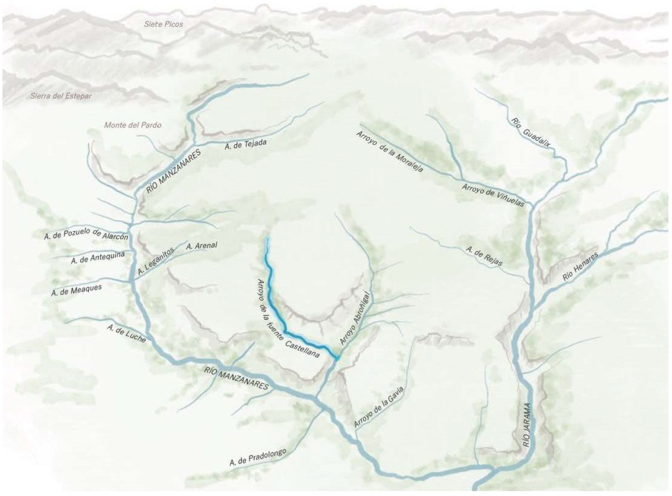
Public works are strongly conditioned by the territory in which they are situated and must adapt to the constraints imposed by physiography and lithology. Roads are designed according to the terrain’s slopes; bridges are located at strategic points along the rivers; and supply networks follow the level curves (
Figure 1).
Understanding a territory’s structure is the essential starting point for achieving its proper use. Therefore, it is useful to approach the analysis of Madrid’s public works against the backdrop of the physical characteristics of the Madrid region and the origins of both its current relief and the materials filling its depressions [
4]. Although this territorial viewpoint underpins the sociocultural dimension, the current literature emphasises the physical traces of public works’ heritage [
5] while neglecting their interplay with cultural significance. Some studies examine present-day social perceptions but omit historical legacy [
6].
The city of Madrid is located in the Depression or Sedimentary Basin of the Tajos River, south of the Central System, and its urban development rests upon two main physiographic units. The Campiñas, which are dominant, consist of extensive rolling plains that form watersheds with their slopes and are composed of successive stepped terraces descending towards the riverbeds. The Vegas, on the other hand, correspond to the valley floors of these watercourses [
7].
Having established these circumstances, we can analyse Madrid’s public works according to the different physiographic areas. We shall subsequently examine its supply networks and road and rail transport systems.
2.1. Water Supply Networks
Madrid’s origins date back to the 9th century, on a hillock of detrital sediments generated by the erosion of the Manzanares River’s tributaries. In the year 865, the Emir of Córdoba Muhammad I decided to build a fortress at this point, named Mayrit (matrix, watercourse or stream). It was a suitable settlement thanks to the spring that rose in the now-vanished arroyo de la Fuente de San Pedro, whose ancient bed is today occupied by Segovia Street [
8].
Regarding Madrid’s lithography, it should be noted that the Madrid countryside is composed of arkosic rocks and arkosic microconglomerates with a red clayey matrix that gives them a cohesive character that can sometimes be quite notable. The arkosic facies have good excavation capacity and moderate-to-high permeability.
This composition of Madrid’s soil was key to supplying Madrid between the 9th and 19th centuries. During the Muslim rule, a water catchment system was implemented that not only persisted through the rest of the Middle Ages but was expanded and improved during the reigns of the Habsburg and Bourbon dynasties. This was the Eastern technique of “qanats”, “khanats” or, more commonly, “viajes de agua” (water “trips”) [
9,
10,
11,
12,
13].
This system consisted of excavating networks of wells and drainage galleries that conducted groundwater accumulated in the subsoil to fountains via gravity, following the land’s natural slope. Where the sand and gravel, which filtered the water, met impermeable loam and clay, water accumulated. In areas where the water table was close to the surface, mines could easily be created to capture and direct water towards the urban centre. Thanks to this, Madrid came to have up to 75 public fountains, connected by a network of 30 “qanats” exceeding 124 km. More than half of this length, about 70 km, corresponded to the five main “viajes”: Alto Abroñigal, Bajo Abroñigal, Amaniel, Alcubilla and Castellana.
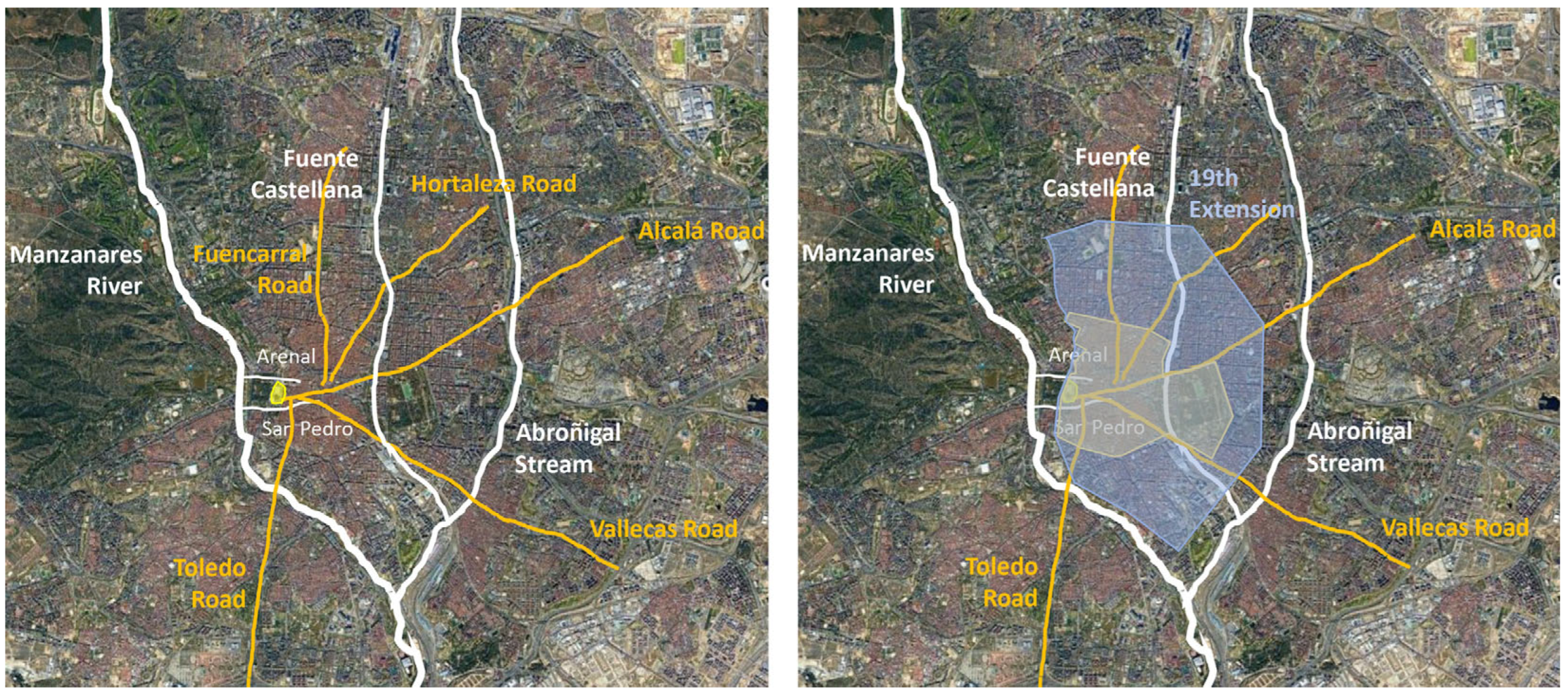
Continuing with the Manzanares tributaries related to public works, the Arenal stream must be mentioned. If the San Pedro stream was a natural defence for Madrid to the south, this one was to the north, along with the Leganitos stream (present-day San Vicente Street). Arenal Street takes its name from this stream, over which was built the Caños del Peral fountain, one of the most important in Habsburg Madrid.
The Abroñigal stream, which crossed the west of the city, remained separate from the urban centre until the 20th century, giving its name to two other important “viajes de agua”. However, it has been buried since the 1970s under the M-30 motorway, with the roadway closely following its original course.
The Fuente Castellana stream—a right-bank tributary of the Abroñigal—not only gave its name to the Paseo de la Castellana but continues to define Madrid’s primary north–south axis. Moreover, the broad valley carved by this watercourse has historically accommodated medium-span urban infrastructures crossing its path. It began to be buried in the 16th century and has been fully culverted since the 19th century. Its waters now flow beneath the avenues Paseo del Prado and Recoletos and Méndez Álvaro Street. The stream rose at what is now Plaza de Emilio Castelar, where in 1883, the foundation stone of the Castellana fountain was laid, taking its name from the spring (
Figure 2).
The exponential growth of Madrid, which by the mid-19th century had reached 200,000 inhabitants, required greater quantities of better-quality water. The medieval system was insufficient, contributing to health problems such as typhoid fever epidemics. After a thousand years of water supply with “viajes de agua”, work began in 1851 on the Canal de Isabel II.
It was decided to transport the water as directly as possible to Madrid; therefore, the 70 km of canal consists of several tunnels, aqueducts and siphons to cross valleys and ravines [
14]. Of the original canal system, six aqueducts survive within Madrid’s city limits—enduring vestiges of stream crossings that were gradually urbanised over time. On the other hand, the reservoirs (1858, 1879, 1915, 1935…) were located on the watersheds between the Manzanares, the Castellana and the Abroñigal watercourses.
In addition to supply works, Madrid has also been the subject of works to channel the Manzanares River. As early as the 16th century, there was a project to make it navigable—something that did not become reality until the 18th century with the (failed) construction of the Real Canal del Manzanares. Finally, the first works were carried out on a small scale between 1914 and 1925. Then, between 1956 and 1958, the riverbanks were urbanised, and levees and small dams were installed to contain potential flooding [
15,
16,
17,
18,
19,
20,
21,
22,
23].
2.2. Transport Networks
2.2.1. Roads, Motorways and Bridges
Madrid’s earliest public works are related to watercourses, and particularly to the Manzanares River. In the Middle Ages, Madrid already had important roads and bridges, but it was after becoming the capital in 1561 that territorial organisation around the city began. The Habsburgs established a systematic communications network, anchored by monumental bridges, such as the iconic Segovia Bridge. But it was during the reign of Charles III (1759–1788) that the scheme of six radial roads connecting the Court with coastal cities and their ports was reinforced. The bridges of Toledo and San Fernando were built at this time [
24,
25,
26].
The basic road network of the historic centre barely changed from the Middle Ages. By the mid-19th century, it was bounded by the Paseo de Ronda, a ring road following the perimeter of the Cerca (Walls) de Felipe IV, and by the accesses of the radial roads. The Paseo del Prado (the already channelled Castellana stream) was already by then the central axis organising the city. This scheme remained in place until the 1950s.
From 1851, the Canal de Isabel II permitted new demographic growth and expansion of housing. The Cerca de Felipe IV ceased to be the boundary as the city extended eastwards to the Castellana–Abroñigal drainage divide, a proposal of engineer Carlos María de Castro’s expansion plan. Likewise, along the six radial access roads to the urban core, population centres grew [
27]. The ravine of the San Pedro stream became the starting point of Segovia Street during the reign of Philip II. The first viaduct was built over it in 1872, while the current one dates from 1942 [
28].
In the 20th century, Madrid’s main road network was still strongly radial, but the new city extension project by urbanists Secundino Zuazo and Herman Jansen in 1927 contemplated the need for a ring road to facilitate connections between peripheral centres.
During this period, the first concrete bridges emerged, such as the Reina Victoria bridge and, later, the Puerta de Hierro bridge for the new layout of the La Coruña road. From 1930, new urban bridges were built [
29], notably those in the Ciudad Universitaria. After the Civil War, a new eastern access was planned for the Barcelona Road, for which the Avenida de América bridge over the Abroñigal stream was erected.
The Paseo de Ronda, the boundary of the 19th-century expansion and Madrid’s first ring road, became over time immersed in the urban fabric. To cross it, new bridges were gradually created throughout the 20th century, such as the elevated crossings at Cuatro Caminos, Francisco Silvela or Pedro Bosch. Furthermore, to cross the Paseo de la Castellana, situated at a lower level due to its status as a former watercourse, the Raimundo Fernández Villaverde and Juan Bravo bridges were constructed [
30,
31].
The 1947 Urban Planning Scheme, or the “Gran Madrid Plan”, emerged after annexing nine municipalities to the capital, extending the city especially eastwards and southwards. For this reason, the aforementioned new access for the Barcelona Road led to consideration of the Abroñigal stream’s course as a north–south axis alternative to the Castellana that would connect other radial roads: Burgos-France, Valencia and Andalucía.
Thus arose Madrid’s second ring road, the M-30. The courses of the Abroñigal and Manzanares were utilised to create this urban motorway. To connect the city centre with districts like La Latina, Usera, Vallecas and La Elipa, new bridges were built to stitch together the gap created, both for vehicles (Ventas bridge) and pedestrians (Fuente del Berro footbridge). Over time, road junctions also emerged to connect different highways (Norte and Puerta de Hierro junctions). The M-30’s closure came in the 1980s, with a more urban and less aggressive solution: the Ilustración Avenue [
32].
For Miguel Aguiló, the M-30 runs “along the main watercourses and valleys that shaped the city”. Thus, he notes the motorway’s marked fluvial character: “its route runs almost entirely along the watercourses that defined the urban form later called ‘the almond’. The entire western and southern flank of the city is bounded by the Manzanares River. Almost all the eastern side is defined by the Abroñigal stream, which flows, like the river’s first stretch, north-south, following the altitudinal gradient characteristic of the province” [
33].
Increasing traffic led to planning a new ring road. Work on the M-40 motorway began in 1987 and lasted a decade. Intersections with radial roads required new bridges and footbridges (Barrial bridge) and even tunnels, such as those under Monte del Pardo. Finally, the M-30 itself was buried along its stretch next to the Manzanares. In total, 6 km of tunnels was created between 2003 and 2007, enabling the riverbanks to be adapted under the Madrid Río project, which allowed urban wounds to be healed, connected neighbourhoods for pedestrians (Cáscara and Arganzuela footbridges) and generated new green areas [
34,
35].
2.2.2. Railway Lines
The arrival of the railway in the capital with the Madrid–Aranjuez line in 1851, the development from 1856 of three new railway lines and the construction of their major terminus stations drove the creation of a new transport network superimposed on the road network. The railway routes required new bridges that were built with a new material, iron, and new construction techniques.
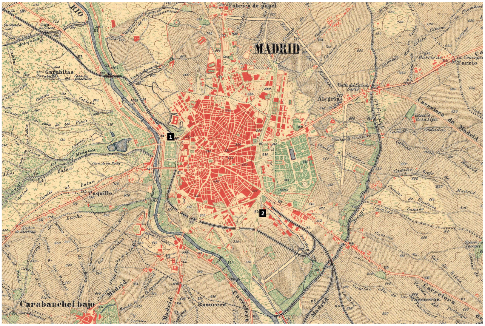
For its arrival in Madrid, the Madrid–Zaragoza–Alicante line used the course of the Castellana stream. Its terminus, the Mediodía Station (now Atocha Station), was built at the point where the stream’s channelling ended, as can be seen in an 1875 map (
Figure 3). Similarly, the terminus of the Madrid–France line, the North Station (now Príncipe Pío), was located at the confluence of the Leganitos stream with the Manzanares River.
Trains leaving the Atocha Station ran parallel to the Valencia Road, crossing the Abroñigal stream before leaving Madrid. Trains heading north crossed the Manzanares via the Franceses bridge. The third line, starting from the Delicias Station, also ran parallel to the river until crossing it near the Princesa bridge, where the Andalucía Road ran [
36].
Madrid’s railway layout remained largely unchanged until the 1930s, when the railway links were planned. The western, southern and southeastern lines were redirected to the Atocha Station, and in the city’s north, the Chamartín Station was created as a terminus for the rest. The tunnel connecting them, known as the “Túnel de la Risa” (Laughter Tunnel) due to its prolonged construction, was built under the ancient course of the Castellana stream. Commuter networks expanded, but the routes gradually became independent of the terrain [
33,
37] (
Figure 4).
3. Materials and Methods
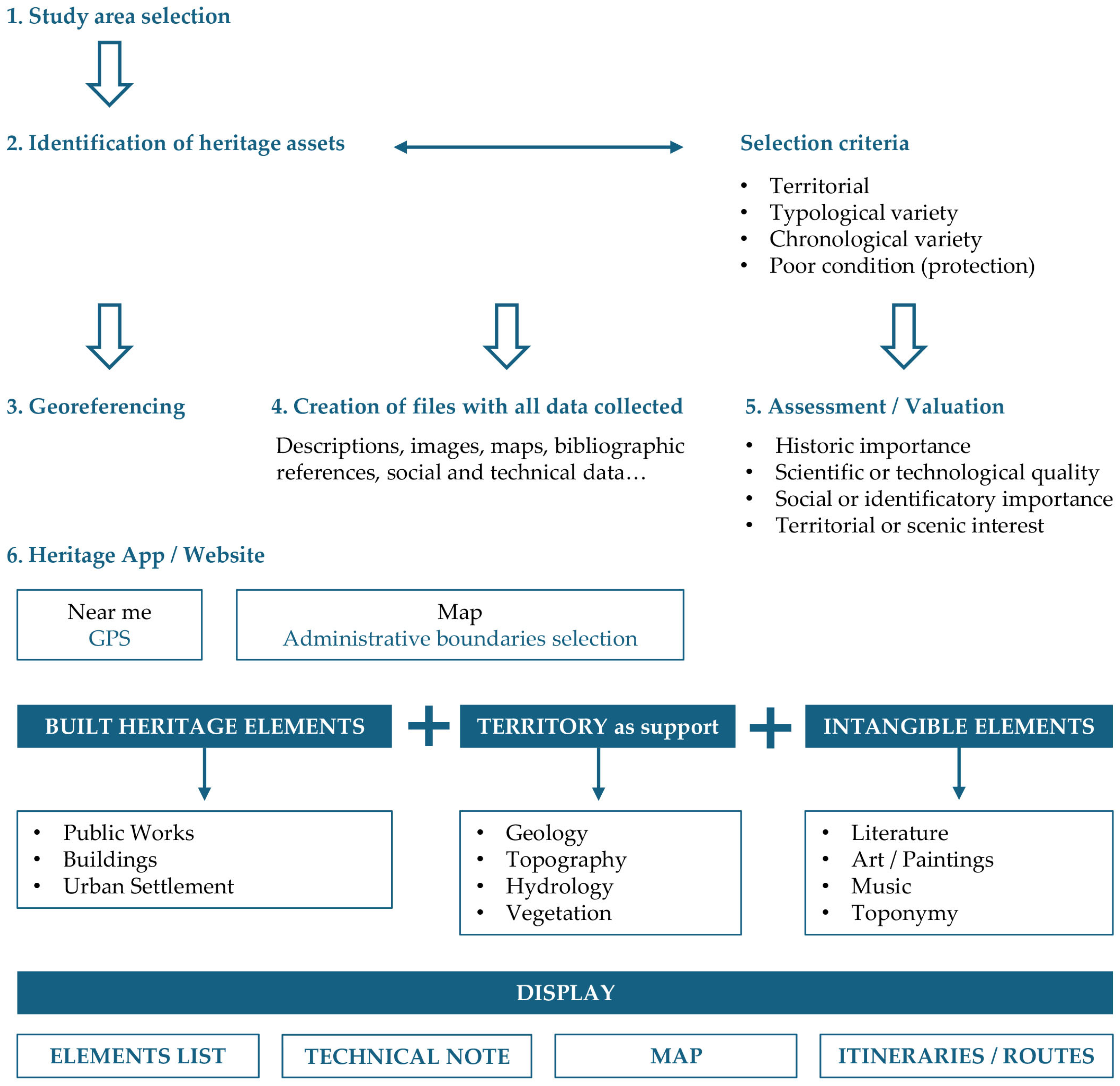
The methodology deployed is illustrated in
Figure 5. The heritage elements to be spotlighted in a given area of study (Madrid city) were identified in accordance with pre-defined selection criteria. After georeferencing the works (53 bridges, 44 stations and 42 water elements), the respective datasheets were drawn up and used to categorise each work and analyse its values (historical, technical, cultural, landscape, uniqueness…). Although each sample is limited, it is also homogeneous and sufficiently representative in typological terms. Likewise, the time span covered was broad, incorporating works from Madrid’s origins to some of the most recent and generally least studied.
The first stage consisted of directly (fieldwork) or indirectly (documentary sources) identifying the elements of interest, which were then geopositioned and characterised by descriptors, such as name, coordinates, type/subtype, date/author, physical description, literature and graphics (photographs, drawings, illustrations). Such standard fact sheets were then used to record the most prominent features and representative values of the works at issue.
The archival and documentary work carried out to compile diverse information about each studied work (reports, plans, surveys, historical and construction process photographs, etc.) stands out, enabling an in-depth analysis. This allowed the understanding of different public works, their surroundings and their networks, as well as providing them with an assessment grounded in each of the value’s criteria.
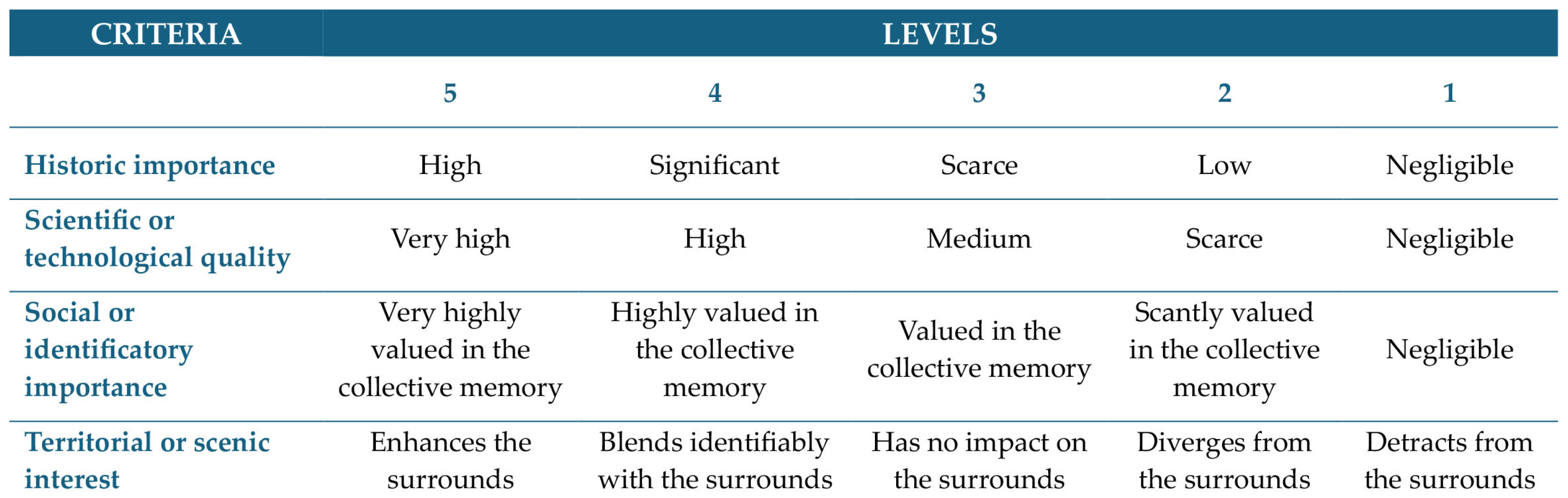
Bridges, stations, reservoirs, fountains, aqueducts, as well as transport networks and the city of Madrid’s water supply system were studied from four perspectives, assigning a score between 1 and 5 for each heritage value category (
Figure 6):
Historical: Their evolution was examined, parallel to Madrid’s transformation and demographic growth, while analysing urban development, communications and main accesses, the road/rail networks and the water supply systems.
Territorial: To show the close relationship between public works and the territory where they are situated, an analysis was conducted of Madrid’s physiography and lithology, both essential for finding the best solutions in locating, constructing and operating its engineering solutions.
Technical: The technical aspects of the different types of works were studied, linked to engineering history and this discipline’s progress. Emphasis was also placed on their authors and the postulates guiding them, as well as the innovations they incorporated, or the materials used.
Social: Finally, the imprint that each type of work had left on Madrid’s society was investigated. To achieve this, narratives, images, films and other cultural manifestations helping form an approximate view of each work’s importance in artistic expressions (literature, painting, photography or cinema) and in citizens’ collective memory were analysed.
The compiled data included landscape intangibles (literature, painting, music, folklore, traditions…) and information related to the place names, accessibility and landscape conversion. The starting point was a search conducted using documentary sources and cultural catalogues to identify the factors that determine the public works–society relationship. Such elements contribute to an understanding by the public at large and link the works to a place’s cultural fabric. Inter-relationships were subsequently established among the factors or elements identified. All the data and material compiled, categorised and organised, were then entered into the database that feeds the mobile app or website where the information can be queried in an orderly manner.
These are interactive websites, where users can navigate different cartographic bases of Madrid with geolocated elements. Each work is associated with a record showing its name, location, type–subtype, authors, materials, key dates (construction, restoration, etc.), description of the work and its surroundings, historical context, technical and cultural data, bibliography and graphic material (photos, plans, drawings…).
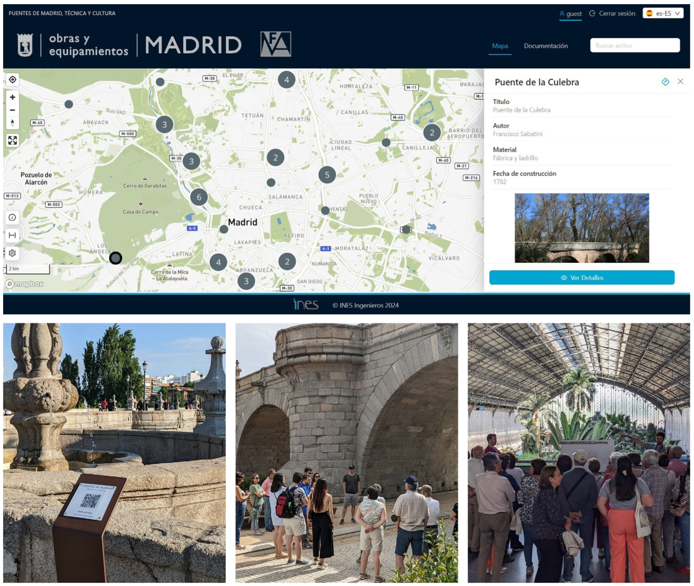
- ○
The bridges dissemination platform (
https://madrid.puentes.app/) is the most complete, since, thanks to collaboration with the INES engineering firm and Madrid City Council, posts with QR codes redirecting users to the website were designed and placed next to the works. Additionally, self-guided routes in digital leaflets were created for users to download, and the option to add three types of cartographic layers to the base map was incorporated: historical maps covering Madrid from the early 17th century to the 1960s; a 2012 land use map; and a set of orthophotos from the 1950s to the 2000s. The website’s interactive map integrates 3D models of key bridges.
- ○
- ○
The third platform, about Madrid’s hydraulic heritage, is currently under development and will follow the same structure as the others.
It is important to highlight that the two available platforms include, in each record, summary videos of the works filmed by students from the Madrid School of Civil Engineering at Universidad Politécnica de Madrid. These videos enable virtual visits to the works and form part of coursework in the History, Art and Aesthetics of Civil Engineering subject within a service-learning (S-L) methodology project that won the university’s first and second S-L prizes in 2022 and 2023, respectively. Here, students became guides and taught citizens and vulnerable groups about the bridges and stations (
Figure 7).
This working methodology was applied to the three types of public works. First, the bridges were studied, then the stations, and finally, Madrid’s water features. From the outset, it was clear that the interest lay not only in analysing the works separately but in linking them to the origin and development of the city’s urban fabric. Thus, bridges are connected to the roads, streets and motorways they extend; stations are related to railway lines and urban spaces, from squares to gardens; as for water, its heritage elements are important not only in themselves but as part of the supply networks feeding them. These three groups of elements were analysed with the territory firmly in mind, were conducted with the territory firmly in mind, from soil composition to relief, which, together with public works, have shaped present-day Madrid.
4. Results
The analysis of Madrid’s main bridges, roads, routes, stations and hydraulic works, and their comparison with the current urban fabric, yielded three new approaches to the city’s public works’ heritage (
Figure 8) and its urban imprint.
4.1. Bridges, Streets and Roads
Usually, bridges are analysed and categorised by their chronology, type and materials. In this study, their location is additionally considered as an essential aspect of urban formation; location proves a key element in the work’s meaning and place-making.
Based on this distribution, the 52 bridges analysed in this research were divided into four groups (only 44 are mapped; the remaining ones lie outside the urban representation area). The first group comprises the oldest bridges—those built to overcome Madrid’s earliest obstacles. They belong to the Valleys and Manzanares River group. From a physiographic perspective, they are located in the Tajo Trench’s Vegas, built on an alluvial base (sands, gravels, clays and silts). The second group consists of Urban Bridges, now integrated into the city’s fabric as part of its streets. Most are situated in the Campiña, except for those on consolidated ground and Ventas bridge, located over the ancient Vega del Abroñigal.
Most of the bridges along the Rondas and the M-30 motorway—which form the third group—are also located in the Campiña. These bridges were part of Madrid’s first rapid transit arteries or were built to cross them, enabling connectivity between the city centre and the earliest neighbourhoods on the opposite side. Finally, the fourth group comprises Periphery Bridges, characterised by their role in connecting new urban development zones (Programas de Actuación Urbanizadora—PAUs), extending bicycle lane networks, providing access to new transport terminals, etc. Most of these peripheral bridges are in the Campiña with the same characteristics (detrital facies, arkoses), except for those in the Vallecas expansion, also in the Campiña but on a lithological base of chemical and transitional facies (marls, clays, gypsum…), the bridges over the Manzanares and those over ancient streams, located in Vegas.
The first group’s bridges are those most closely related to Madrid’s relief, since they were created to span watercourses in its discrete valleys. The main ones are located over the Manzanares River and are connected both to Madrid’s primitive roads and the first railway routes. The urban bridges also coincide with watercourses, specifically those that vanished after being erased by urban expansion. The Bailén Street viaduct highlights the existence of the ancient San Pedro stream’s ravine, just as the Juan Bravo bridge reveals the slope of the former Castellana stream. Most ring road bridges are elevated crossings, built to streamline traffic in different directions. The M-30 motorway remains faithful to the Abroñigal stream, a stretch where bridges and footbridges still mark this imprint on the land. The periphery bridges are the most detached from relief, since new urban developments and the public works serving them have ceased to depend, thanks to construction advances, on traditional obstacles (
Figure 9).
4.2. Stations and Rail Tracks
Railway constituted a key element in Madrid’s development. It was the means capable of transforming the relative isolation at the centre of a country without navigable waterways and with an unfavourable road network. It also drove industrial activity that would progress closely linked to stations and rail lines. Madrid’s first line was the connection with Aranjuez inaugurated in February 1851. It originated in Madrid at the Mediodía stop, which would mark the location of what remains the symbol of railway stations and the nation’s first station today: Atocha (1892). These were followed by the Delicias station (1880), serving as the terminus for trains to Portugal and western Spain, and North Station (now Príncipe Pío Station, 1882), providing connections to France. All were defined as terminus stations, heads of lines and emblems of the railway companies promoting them.
The railway linking Príncipe Pío and Atocha stations from 1884 was designed parallel to the Manzanares River. Once on Paseo de las Delicias, it follows the Castellana stream’s right bank and crosses it to continue along the opposite bank until the MZA line’s terminus. Although out of use since the 1980s, this “railway corridor’s” urban imprint remains present in the alignment of Santa María la Real de Nieva Street, Paseo de Juan Antonio Vallejo-Nájera Botas and, of course, Ferrocarril (Railway) Street (
Figure 10).
4.3. Water Supply Networks
The public works constituting Madrid’s water supply network are a little-known technological and cultural heritage. From medieval wells and “viajes de agua” to the most modern distribution and pumping systems, their most interesting elements and routes, unique in character and technological interest, allow narrating hydraulic engineering’s evolution over recent centuries. They display great variety in utilisation strategies and employ diverse materials and resistant mechanisms. This, together with their authenticity and typological and technological purity, representative of water catchment, conduction and storage methods in each period, makes these systems a rich heritage for civil engineering.
The imprint of Madrid’s water supply networks is enduring, despite being the least visible of the three public works systems. The conduits are often underground, and the city’s own growth keeps concealing their elements.
In the Dehesa de la Villa, one can still trace the Amaniel “viaje de agua”, thanks to the pyramidal granite caps covering the inspection wells that remain. With some attention, one can also find in Madrid’s streets manholes inscribed “ancient viaje de agua”, and in Carros Square, the pavement markings reflect the route of an Islamic-era channel [
38]. The location of the Caños del Peral fountain is also marked in the pavement, in this case that of Isabel II Square, whose history and archaeological remains can be visited, curiously, after accessing another public work: the Ópera Metro Station.
Although Canal de Isabel II’s original route has dams, aqueducts and other monumental elements in the Madrid mountains, in the city, it only becomes visible at certain points—for example, in Rodríguez Sahagún Park, where some of its aqueducts can still be seen despite being adjacent to a slope. Parallel to it also runs the winding Paseo de la Dirección, originally a path following the Canal’s direction to ensure its maintenance. Its zigzag layout resembles the channellings, since it follows the contour lines determining its route.
The last great aqueduct in the city, called Amaniel, was built to span the start of the Cantarranas stream’s course, which crossed the present-day Ciudad Universitaria (University Campus). In the Chamberí district, the water reservoirs remain, strategically positioned in what were then the city’s outskirts. They were built on the watershed between the Manzanares River and the Castellana and Abroñigal streams, higher than the populated area. This elevation ensured sufficient water pressure to supply the city. Over time, as the city expanded to higher ground, elevated reservoirs and new underground deposits were needed, always built considering the capital’s relief and watersheds.
The basin of the fountain inaugurating the Canal on San Bernardo Street still survives, but it is no longer there nor in Puerta del Sol, where it was later moved. Currently, it can be found in Casa de Campo parklands, next to the Manzanares. Therefore, the traces remain, but not other elements. The aqueducts, reservoirs and streets remain where they were built, but the fountains and spouts acquire a movable character in the city, and many examples are found relocated to new sites (
Figure 11).
5. Discussion
It is common to consider the formative role of public works in the city regarding their physical capacity to provide certain basic services or functions. Some examples are settlements around roads/highways or at route crossings or a district’s rapid expansion promoted by a new metro station, etc. [
39].
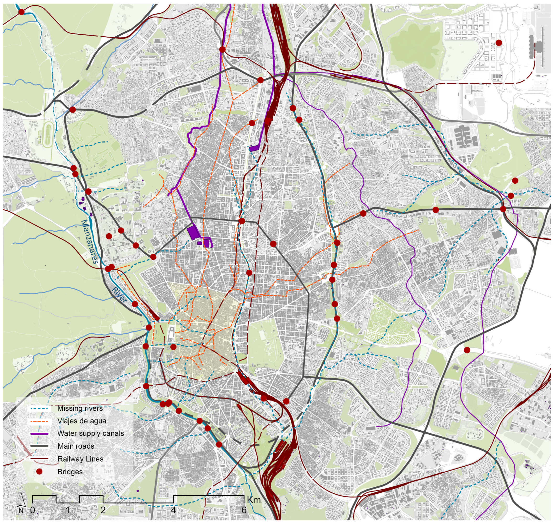
Public works generate traces that endure over time. In Madrid, rivers, streams and watercourses have been adapted and channelled to establish roads. These roads have transformed into highways and, in some cases, motorways. Cities incorporate layers (territory, hydrographic network, urban fabric, etc.) where constructions are also superimposed (
Figure 12). However, buildings appear, transform and often disappear, but public works remain fixed, anchored to the specific points for which they were created, shaping the city around them.
5.1. Physical Imprint
Nodal public works (bridges, stations, reservoirs…) are part of a network or system (roads, highways, railways, canals…) that organise and interconnect territories. Over time, they acquire new values and uses beyond their original function. While nodal works have a greater presence and recognition, linear works are often hidden or transformed by urban growth, only being valued once they cease to function. However, both types of work leave physical traces, either through the works themselves or through toponymy, which highlight their importance in shaping the city’s identity.
The outline of Madrid’s hydrographic network, and how it has shaped the materials of the terrains through which it has formed, is primordial for understanding the functional and design solutions of the bridges built in Madrid, both for the territorial and demographic expansion of the capital’s metropolitan area [
40,
41,
42]. The bridge “stands out among constructions for its privileged significance, as the very symbol of connection above obstacles” [
43]. And this symbolism has been especially relevant in urban centres. Bridges are far more than structures spanning obstacles: bridges build cities. Therefore, to their technological, historical, resistant and constructive values must be added representative, emotional, cultural and identity-related meanings.
In this territorial context, the Manzanares River and its tributary streams are the main characters of the historical origins of Madrid. Madrid’s growth, following the communication routes, has necessarily intersected, time and again, with this hydrographic network to which it has had to adapt or which it has made disappear, depending on the case. Of all these obstacles, undoubtedly the most significant was the Manzanares River. Although the first crossing dates back to the Middle Ages, it was a natural barrier to the city’s expansion until at least the 17th–18th centuries.
Although communication between Madrid and Segovia now occurs via the A-6 motorway, it is no coincidence that Segovia Street still starts from the city centre, maintains an east–west orientation and passes over the same bridge from the 16th century. An identical situation is found in Toledo Street, which starts at Plaza Mayor itself to head south and cross the Manzanares via its namesake bridge, or Alcalá, Madrid’s longest street, which advances eastwards from Puerta del Sol.
For their part, historic railway routes follow fluvial courses. The entry from the southeast leant on the Castellana stream’s course until reaching the Mediodía stop, today the Atocha Station, and this fact conditioned the level difference, about 9 m, which persists today between the platforms, lower at the watercourse’s level, and the urban level of Carlos V Square and Paseo del Prado. The connection from the north crosses the Manzanares River and follows its right bank until Cuesta de San Vicente, one of the city’s historic gates. Stations are exchange points. Places for relationships, urban connection and civic life. They are common spaces forming part of shared experiences. They are meeting points, emotional spaces of connection and farewell, familiar places; their use makes them environments where one quickly learns how to enter, exit or transfer faster. In the 21st century, the 19th century’s historic stations have been transformed: Atocha hosts Spain’s largest high-speed rail station; Delicias has become a railway museum; and Príncipe Pío is now a transport hub and a shopping centre.
The importance of Madrid’s water supply system’s heritage stems from water’s indispensable role since the city’s 9th century establishment (
Figure 13). It is considered proven that Madrid’s name originates from water. The current name is derived from
Mayrit, whose root comes from the Arabic Mayra, meaning watercourse or stream [
44]. The medieval Christian motto of the town was also related to the territory’s abundant water: “I was built upon water/my walls are of fire./This is my insignia and emblem”. The medieval “viajes de agua” functioned efficiently through a combination of Madrid’s soil composition and the city relief’s north–south gradient: gravity itself conducted water to the population core. Later, in the topographical reports ordered by Philip II, pride was already taken in the new capital’s water quality: “It has the most and best fountains, and the finest water ever seen” [
45,
46]. Even in the 19th century, after bringing water from the Lozoya River to the city, writer Benito Pérez Galdós highlighted the water’s quality, noting that “Madrilenians maintain that nowhere in the world is better water drunk; and I believe they are right. It is of phenomenal transparency and lightness” [
47].
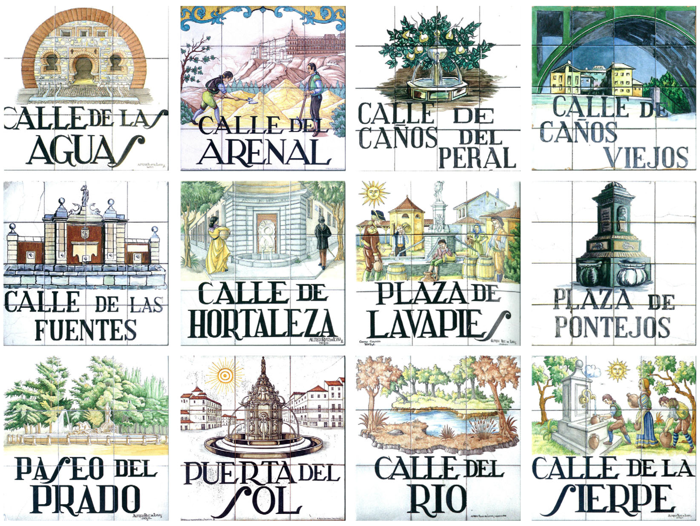
The legacy of Madrid’s hydraulic heritage manifests not only in the surviving physical infrastructure—including accessible historic qanats like the Amaniel and Fuente del Berro—but also in the city’s enduring street network topology, be it names directly referencing water (C/de las Aguas), its courses (C/del Arenal), its fountains (C/de las Fuentes) or its qanats (C/de Amaniel), or proper names of the engineers who made possible the Canal de Isabel II project (C/de Lucio del Valle, C/de Boix y Morer).
5.2. Cultural Imprint: Future Research
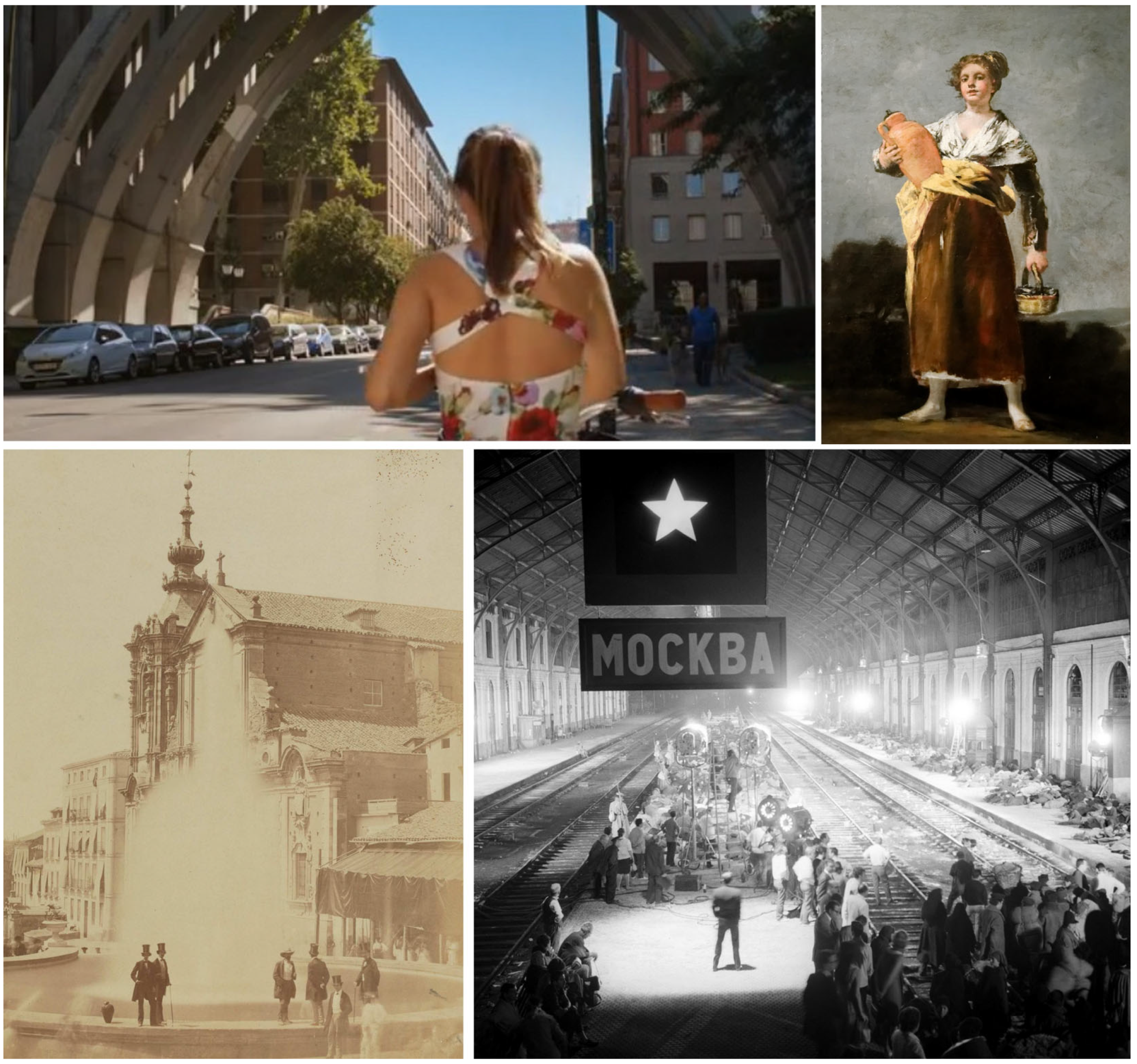
Indeed, public works are associated with technological, scientific, documentary, innovation and landscape values. It is less common, however, to attribute social and cultural values to them. Yet, the analysis conducted reveals how civil engineering works have left an indelible mark on their citizens’ collective memory, particularly in cities. In Madrid, this relation is obvious (
Figure 14).
Roads, bridges, railway lines and their stations are fundamental in citizens’ daily lives, being essential for their everyday mobility. Thus, from the moment a public work is built, very diverse social and cultural aspects begin associating it with its inhabitants. Through literature, photography or cinema, these engineering works have become representations of different eras and events and, at times, have even turned into city symbols. The depiction of these elements through various popular artistic media brings them closer to society, ensuring they remain in the collective imagination and are thus more valued.
Throughout history, bridges have incorporated new values for society. Initially conceived as simple crossing points over rivers and other natural obstacles, later as crossings over fast connection routes, today, they are understood, also as landscape landmarks, viewpoints and symbols. They have acquired greater social value and, as part of this process, have been incorporated into the city design, becoming leisure spaces associated even with environmental and quality-of-life values [
48].
Since its inauguration in 1851, the railway has facilitated the capital’s connections and enabled increasingly faster and simpler journeys. But despite being a transport tool used daily by thousands of Madrilenians, its configuration, circulation, history or impact on urban layout are barely known. On the contrary, stations assume this symbolic value. Built as urban emblems of 19th-century railway companies, they have maintained since then their strong representative character. They are useful sites we provide with an intense civic and emotional charge. They are the familiar places where we access the city or bid it farewell—the meeting points that become cultural references in cinema, painting and literature (
Figure 15).
Water supply networks are far more than structures enabling direct access to water. The underground galleries are, as Haussmann explained in his Mémoire sur les eaux de Paris [
49], like the body’s organs: pure, fresh water, without showing itself to the light, circulates in different flows, and its movement serves life. Water regulation and catchment entails different strategies of land redevelopment, hydraulic works construction and institution creation, but it also plays a fundamental role in developing specific ways of living that adapt to its flows and cycles. The inaccessibility and predominantly underground development of other fundamental constructions, such as aqueducts, water mains and reservoirs, make supply networks unknown and alien systems to society. However, water’s importance for society is such that, around the public works guaranteeing its access, diverse cultural manifestations also emerge. Furthermore, fountains, lakes and rivers are the connection points of relationships and civic life (
Figure 16).
The heritage value of these three categories of public works can be determined by applying the four criteria outlined in
Figure 6. The Paseo de la Castellana, for instance, holds significant historical relevance, having been conceived in the 18th century as an urban leisure space linked to scientific institutions such as the Botanical Garden. Its high social value corresponds to the enduring connection that Madrilenians maintain with this axis—300 years later—as it continues to structure the urban centre and host diverse public celebrations. However, its territorial value is somewhat diminished: although its lower elevation compared to adjacent streets remains perceptible, its past as a ravine has been erased. Likewise, its technical value is low, as it was not subject to innovative engineering works, nor did it feature significant structures.
The case of the Juan Bravo Bridge over the Castellana presents the opposite scenario. Although it holds lesser historical value due to its more recent construction, its remaining values are exceptionally high. It was Spain’s first mixed-structure bridge (technical quality); its engineers collaborated with artists to design construction details and the surroundings (landscape quality); and it houses the country’s first open-air sculpture museum. Meanwhile, the plaza beneath its abutments has become a highly valued and frequently used public space (social and cultural quality).
Throughout the research process, several limitations emerged—for instance, the absence of prior literature specifically related to the study topic. Furthermore, working with public works’ heritage invariably presents challenges, as it encompasses vanished assets that are not always easily identifiable. Additionally, the landscapes that form the context for these elements and systems have undergone significant transformation over time—with altered topography, landfilling processes and other modifications—making historical reconstruction particularly complex.
6. Conclusions
Bridges are engineering works that overcome obstacles and give continuity to the road. The essence of bridges is thus dual. On the one hand, by spanning specific obstacles, each bridge can be considered an isolated piece—a landmark that highlights the roads and serves as a point of reference. But simultaneously, these obstacles are spanned to extend the said roads; therefore, bridges are also elements of a whole—a totality formed by routes and itineraries.
Roads define layouts over which the city is built. Historic road connections transform into streets maintaining their alignment. Roads, traces of walls and moats, river and stream courses constitute an underlying pattern of urban development.
The railway’s main function is to connect. Stations welcome visitors into cities and serve as exchange and civic relationship points. The routes of rail lines leave an indelible imprint on the urban fabric and can become barriers that over time are buried, offering new urban spaces. For their part, stations build cities and contribute to linking social groups and enhancing the city and its inhabitants.
Water supply networks link cities with their nearby territory. Historically, city squares have developed around wells and fountains, spaces where communities relate and where the city is enhanced through water.
Public works are linked to the territory where they are located, with relief, geology and hydrology dictating both their design parameters and optimal placement. In Madrid, the Manzanares River and other streams, with their north–south direction, have historically determined city growth. But as the city grew, these obstacles were not only overcome with bridges, but the watercourses themselves became the city’s main streets. The Castellana remains the axis structuring central Madrid, and on both sides, the Manzanares River and the Abroñigal stream have transformed into the great ring road: the M-30. This motorway has also undergone transformations, such as the partial undergrounding to create the great Madrid Río Park.
The city has expanded and continues to grow and transform. Gradually, the original territory is being erased to give way to a consolidated urban network. And although it may no longer be evident where the valleys used to run, which were the easiest passes or the least steep slopes, public works allow us to identify these decisive points. The city advances, and many works disappear or change use. The city absorbs them and, at times, disguises or hides them, but their traces remain. Whether in the toponymy, street layouts or green spaces, they are still present in the urban network. Moreover, through diverse cultural expressions and citizens’ daily experiences, this heritage—whose presence often goes unnoticed—nevertheless leaves a profound imprint on the collective memory.
Author Contributions
Conceptualisation, P.H.L. and J.B.L.; methodology, P.H.L. and J.B.L.; software, Ó.d.C.C. and B.C.A.; formal analysis, P.H.L. and Á.G.P.; investigation, B.C.A. and Á.G.P.; resources, Á.G.P. and J.B.L.; writing—original draft preparation, J.B.L. and Á.G.P.; writing—review and editing, J.B.L. and B.C.A.; visualisation and figures, B.C.A. and Á.G.P.; supervision, P.H.L. and B.C.A.; project administration, P.H.L. and Ó.d.C.C.; funding acquisition, P.H.L. and J.B.L. All authors have read and agreed to the published version of the manuscript.
Funding
This research was funded by Oficina de Aprendizaje-Servicio—Universidad Politécnica de Madrid, Fundación Miguel Aguiló and INES Ingenieros Consultores.
Data Availability Statement
Acknowledgments
This research and the paper were made possible thanks to the invaluable collaboration of the Miguel Aguiló Foundation and INES Ingenieros Consultores. The three service-learning projects (bridges, stations and water in Madrid) went ahead in 2022, 2023 and 2025 thanks to the Oficina ApS—Universidad Politécnica de Madrid. Finally, the authors would like to acknowledge the participation of the following entities, whose strong links with the city, society and the engineering profession were essential: Ayuntamiento de Madrid, ADIF, RENFE, Metro de Madrid, Canal de Isabel II, Colegio de Ingenieros de Caminos, Canales y Puertos, Fundación Ingeniería y Sociedad, Asociación Down Madrid, Asociación Conocer Madrid, Cadena Ser and Radio Nacional de España.
Conflicts of Interest
The authors declare no conflicts of interest.
References
- Aguilar Civera, I. Paisaje e ingeniería: Lo natural y el artificio. Saitabi Rev. de la Fac. de Geogr. i Història 2007, 57, 13–35. Available online: https://roderic.uv.es/bitstream/handle/10550/27283/13-35.pdf?sequence=1&isAllowed=y (accessed on 21 January 2025).
- Aguilar Civera, I. Historia del transporte y de la obra pública como recurso cultural: El Museo del Transporte y del territorio de la Comunidad Valenciana. Scr. Nova. Rev. Electrónica de Geogr. y Cienc. Soc. 2006, 10, 218. Available online: https://revistes.ub.edu/index.php/ScriptaNova/article/view/1273 (accessed on 21 January 2025).
- López Carcelén, P. Atlas Ilustrado de la Historia de Madrid; Ediciones La Librería: Madrid, Spain, 2013. [Google Scholar]
- Martín-Caro Álamo, J.A.; Hernández Lamas, P.; González Alonso, S.; Cabau Anchuelo, B. Fisiografía y litología de Madrid. In Puentes de Madrid. Técnica y Cultura; Hernández Lamas, P., Martín-Caro Álamo, J.A., Eds.; Consejo Superior de Investigaciones Científicas & Ediciones La Librería: Madrid, Spain, 2022; pp. 38–48. [Google Scholar]
- Ioannidis, R.; Sargentis, G.F.; Koutsoyiannis, D. Landscape design in infrastructure projects—Is it an extravagance? A cost-benefit investigation of practices in dams. Landsc. Res. 2022, 47, 370–387. [Google Scholar] [CrossRef]
- Sherren, K.; Beckley, T.M.; Parkins, J.R.; Stedman, R.C.; Keilty, K.; Morin, I. Learning (or living) to love the landscapes of hydroelectricity in Canada: Eliciting local perspectives on the Mactaquac Dam via headpond boat tours. Energy Res. Soc. Sci. 2016, 14, 102–110. [Google Scholar] [CrossRef]
- Pedraza Gilsanz, J.; González Alonso, S.; Centeno Carrillo, J.d.D.; Ascaso Deltell, E. Memoria del Mapa Fisiográfico de Madrid; Consejería de Agricultura y Ganadería de la Comunidad de Madrid: Madrid, Spain, 1985. [Google Scholar]
- Terán Troyano, F.d. En Torno a Madrid. Génesis Espacial de Una Región Urbana; Comunidad de Madrid: Madrid, Spain, 2006. [Google Scholar]
- Cayetano, M. (Ed.) Madrid Acuosa; CentroCentro: Madrid, Spain, 2022. [Google Scholar]
- Verdú Ruiz, M. Algunas consideraciones en torno a los Viajes de Agua madrileños (1690–1750). Diseños de José y Manuel del Olmo y J. B. Sachetti para el Arca principal del Viaje de Abroñigal Bajo. An. del Inst. de Estud. Madrileños 1984, XXI, 117–135. [Google Scholar]
- López-Camacho y Camacho, B.; Iglesias Martín, J.A. Las aguas subterráneas en los abastecimientos: Un decenio de experiencias del Canal de Isabel II. Rev. de Obras Públicas 2000, 3403, 41–55. [Google Scholar]
- Guerra Chavarino, E. Los viajes de agua de Madrid. An. del Inst. de Estud. Madrileños 2006, XLVI, 419–465. [Google Scholar]
- Pinto Crespo, V.; Gili Ruiz, R.; Velasco Medina, F. Los Viajes de Agua en el Antiguo Régimen; Fundación Canal: Madrid, Spain, 2010. [Google Scholar]
- Bernabéu Larena, J.; Cabau Anchuelo, B.; Plasencia Lozano, P.; Hernández-Lamas, P. Use and Management in the Heritage Conservation of the Historic Water Supply of Canal de Isabel II, Madrid. Appl. Sci. 2022, 12, 6731. [Google Scholar] [CrossRef]
- Colegio de Ingenieros de Caminos, Canales y Puertos. La canalización del Manzanares. Rev. de Obras Públicas 1905, 53, 662–663. [Google Scholar]
- Colegio de Ingenieros de Caminos, Canales y Puertos. La canalización del Manzanares. Rev. de Obras Públicas 1906, 54, 284. [Google Scholar]
- Colegio de Ingenieros de Caminos, Canales y Puertos. Canalización del Manzanares. Rev. de Obras Públicas 1906, 54, 304–305. [Google Scholar]
- Colegio de Ingenieros de Caminos, Canales y Puertos. El encauzamiento del Manzanares. Rev. de Obras Públicas 1910, 58, 436. [Google Scholar]
- Colegio de Ingenieros de Caminos, Canales y Puertos. La canalización del Manzanares. Rev. de Obras Públicas 1914, 62, 469–470. [Google Scholar]
- Fungairiño Fernández, E. Encauzamiento y saneamiento del río Manzanares. Rev. de Obras Públicas 1915, 63, 13–19. [Google Scholar]
- Fungairiño Fernández, E. Encauzamiento y saneamiento del río Manzanares. Rev. de Obras Públicas 1919, 67, 121–127. [Google Scholar]
- Mendoza Sáez de Argandoña, C. Obras de canalización y urbanización del Manzanares. Rev. de Obras Públicas 1945, 93, 97–102. [Google Scholar]
- Fuentes López, L.d. La canalización del Manzanares. Antecedentes, características y situación actual de las obras. Rev. de Obras Públicas 1958, 106, 549–555. [Google Scholar]
- Machimbarrena Gogorza, V. Los puentes sobre el Manzanares. Rev. de Obras Públicas 1924, 72, 397–401. [Google Scholar]
- Fernández Casado, C. Madrid y el Manzanares: El río, la ciudad y sus puentes. Rev. de Obras Públicas 1974, 121, 1–12. [Google Scholar]
- Fernández Casado, C. Madrid y el Manzanares: El río, la ciudad y sus puentes. Rev. de Obras Públicas 1975, 122, 147–158. [Google Scholar]
- Comunidad de Madrid. Catálogo Sectorial del Sistema de Infraestructuras Históricas Calzadas, Caminos Reales y Carreteras; Consejería de Vivienda; Dirección General de Arquitectura y Rehabilitación, Área de Arquitectura y Patrimonio: Madrid, Spain, 2007. [Google Scholar]
- Alonso García del Busto, P.; Valdivieso Frutos, A. (Eds.) Puentes, Viaductos y Acueductos en la Comunidad de Madrid; Comunidad de Madrid, Dirección General de Vivienda y Rehabilitación, Conserjería de Transportes, Vivienda e Infraestructuras: Madrid, Spain, 2018. [Google Scholar]
- Nárdiz Ortiz, C. Razón y ser de los puentes urbanos. Rev. Ing. Y Territ. 2003, 65, 4–5. [Google Scholar]
- Corral, A.; Martínez Calzón, J. Puente sobre la Castellana, entre Juan Bravo y Eduardo Dato. Rev. Hormigón Y Acero 1971, 22, 49–58. [Google Scholar]
- Bernabéu Larena, J. Evolución Tipológica y Estética de los Puentes Mixtos en Europa. Ph.D. Thesis, Universidad Politécnica de Madrid, Madrid, Spain, 2004. [Google Scholar]
- Martínez Calzón, J. 25 Años de Puentes Mixtos en España. In Proceedings of the I Encontro Nacional Construçao Metálica e Mista, Porto, Portugal, 21–22 November 1997. [Google Scholar]
- Aguiló Alonso, M. La Construcción del Actual Madrid; ACS: Madrid, Spain, 2013; pp. 81–82. [Google Scholar]
- Corres Peiretti, H.; Seijo Veiguela, C.; García Espinel, J.D.; Calvo Herrera, I.; Grávalos Moreno, J.; Chozas Ligero, V.; Lample Carreras, R.; Viñolo Albione, A. Aplicación de tecnologías avanzadas del hormigón en las pasarelas en cáscara sobre el río Manzanares para el proyecto Madrid Río. Rev. de Obras Públicas 2010, 157, 7–18. [Google Scholar]
- Corres Peiretti, H.; Romo Martín, J.; Sánchez Delgado, J.; Sanz Manzanedo, C. Pasarelas Cáscara del Matadero y del Invernadero sobre el río Manzanares en Madrid. Rev. de Obras Públicas 2011, 158, 39–50. [Google Scholar]
- Martín-Caro Álamo, J.A. Puentes de Fábrica; ADIF: Madrid, Spain, 2013. [Google Scholar]
- García Pérez, A. Indalecio Prieto y los Enlaces Ferroviarios de Madrid; Fundación Indalecio Prieto: Madrid, Spain, 2013. [Google Scholar]
- Fundación de Cultura Islámica. 2024. Available online: https://funci.org/los-viajes-agua-la-plaza-los-carros/ (accessed on 11 March 2025).
- Bernabéu Larena, J.; Aguiló Alonso, M. Las Obras Públicas en la formación de la ciudad. Ciudad Y Territ. Estud. Territ. 2011, 43, 555–560. Available online: https://recyt.fecyt.es/index.php/CyTET/article/view/76082 (accessed on 21 January 2025).
- Arenas de Pablo, J.J. Caminos en el Aire. Los Puentes; Colegio de Ingenieros de Caminos, Canales y Puertos: Madrid, Spain, 2003. [Google Scholar]
- Aguiló Alonso, M. El Carácter de los Puentes Españoles; ACS: Madrid, Spain, 2006. [Google Scholar]
- Aguiló Alonso, M. Forma y Tipo en el Arte de Construir Puentes; Abada: Madrid, Spain, 2008. [Google Scholar]
- Aguiló Alonso, M. Qué Significa Construir. Claves Conceptuales de la Ingeniería Civil; Abada: Madrid, Spain, 2013. [Google Scholar]
- Jiménez Rayado, E. La construcción de la identidad a través del territorio en la Edad Media. El origen bereber del nombre de Madrid. Medievalismo 2020, 30, 269–300. [Google Scholar] [CrossRef]
- Alvar Ezquerra, A. (Ed.) Relaciones Topográficas de Felipe II; Comunidad de Madrid & Consejo Superior de Investigaciones Científicas: Madrid, Spain, 1993; pp. 359–360. [Google Scholar]
- Arroyo Ilera, F. Agua, Paisaje y Sociedad en el Siglo XVI: Según las Relaciones Topográficas de Felipe II; Umbral: Madrid, Spain, 1998. [Google Scholar]
- Pérez Galdós, B. Obras Inéditas. Volumen 1. Fisonomías Sociales; Biblioteca Virtual Miguel de Cervantes: Alicante, Spain, 2019; [1923]; Available online: https://www.cervantesvirtual.com/nd/ark:/59851/bmc0971047 (accessed on 21 January 2025).
- Gil Plana, A.; Hernández Lamas, P.; Martín-Caro Álamo, J.A.; Cabau Anchuelo, B.; Bernabéu Larena, J. Sociedad y cultura en los puentes de Madrid. Inf. de la Construcción 2024, 76, 6359. [Google Scholar] [CrossRef]
- Haussmann, G.E. Mémoire Sur les Eaux de Paris Présenté à la Commission Municipal par le Préfet de la Seine; Vinchon: París, France, 1854. [Google Scholar]
- Ediciones La Librería. Placas de las Calles de Madrid; Ediciones La Librería: Madrid, Spain, 2018. [Google Scholar]
Figure 1.
Diagram of Madrid and its conurbation’s main watercourses. Source: [
3].
Figure 1.
Diagram of Madrid and its conurbation’s main watercourses. Source: [
3].
Figure 2.
Relationship between Madrid’s watercourses, its main roads and its urban growth over the centuries: Comparison between Middle Age (yellow shape) and 19th Century city extension (blue shape). Source: Authors’ elaboration using Google Maps.
Figure 2.
Relationship between Madrid’s watercourses, its main roads and its urban growth over the centuries: Comparison between Middle Age (yellow shape) and 19th Century city extension (blue shape). Source: Authors’ elaboration using Google Maps.
Figure 3.
Map of Madrid in 1875 showing the route of the rail link between Príncipe Pío (1) and Atocha (2) stations. In black, railway lines; In red, buildings and roads; In green, parks and green areas. Source: MTN50ImpresoSerie 1875–2022 CC-BY 4.0 Instituto Geográfico Nacional.
Figure 3.
Map of Madrid in 1875 showing the route of the rail link between Príncipe Pío (1) and Atocha (2) stations. In black, railway lines; In red, buildings and roads; In green, parks and green areas. Source: MTN50ImpresoSerie 1875–2022 CC-BY 4.0 Instituto Geográfico Nacional.
Figure 4.
Relationship between Madrid’s watercourses, its main roads and its urban growth over the centuries: 19th to 21st century transport network growth in comparison to Middle Age (yellow shape) and 19th Century Madrid (blue shape). Source: Authors’ elaboration using Google Maps.
Figure 4.
Relationship between Madrid’s watercourses, its main roads and its urban growth over the centuries: 19th to 21st century transport network growth in comparison to Middle Age (yellow shape) and 19th Century Madrid (blue shape). Source: Authors’ elaboration using Google Maps.
Figure 5.
Flowchart illustrating the methodology applied. Source: The authors.
Figure 5.
Flowchart illustrating the methodology applied. Source: The authors.
Figure 6.
Assessment/valuation categories and scores/levels given for the heritage value analysis. Source: The authors.
Figure 6.
Assessment/valuation categories and scores/levels given for the heritage value analysis. Source: The authors.
Figure 7.
Interactive map of the digital platform for the bridges
https://madrid.puentes.app/. Down: Three examples of bridges heritage dissemination: QR code information next to Toledo bridge, students guided tour of Madrid’s bridges and students guided tour in Atocha station.
Figure 7.
Interactive map of the digital platform for the bridges
https://madrid.puentes.app/. Down: Three examples of bridges heritage dissemination: QR code information next to Toledo bridge, students guided tour of Madrid’s bridges and students guided tour in Atocha station.
Figure 8.
Some representative public works of Madrid. Bridges: Toledo, Reina Victoria and Arganzuela. Stations: Atocha, Príncipe Pío and Delicias. Water reservoirs: Santa Engracia, Plaza de Castilla and Matadero. Source: Fundación Miguel Aguiló; the authors.
Figure 8.
Some representative public works of Madrid. Bridges: Toledo, Reina Victoria and Arganzuela. Stations: Atocha, Príncipe Pío and Delicias. Water reservoirs: Santa Engracia, Plaza de Castilla and Matadero. Source: Fundación Miguel Aguiló; the authors.
Figure 9.
Map of Madrid with its main bridges and roads. (Disappeared elements). Source: Authors’ elaboration.
Figure 9.
Map of Madrid with its main bridges and roads. (Disappeared elements). Source: Authors’ elaboration.
Figure 10.
Map of Madrid with its main stations and railway tracks. a—Santa María la Real de Nieva St.; b—Paseo de Juan Antonio Vallejo-Nájera Botas; c—Ferrocarril St. (Disappeared elements). Source: Authors’ elaboration.
Figure 10.
Map of Madrid with its main stations and railway tracks. a—Santa María la Real de Nieva St.; b—Paseo de Juan Antonio Vallejo-Nájera Botas; c—Ferrocarril St. (Disappeared elements). Source: Authors’ elaboration.
Figure 11.
Map of Madrid with its main water supply networks. a—Paseo de la Dirección; b—Rodríguez Sahagún Park; c—Isabel II Sq. (Disappeared elements). Source: Authors’ elaboration.
Figure 11.
Map of Madrid with its main water supply networks. a—Paseo de la Dirección; b—Rodríguez Sahagún Park; c—Isabel II Sq. (Disappeared elements). Source: Authors’ elaboration.
Figure 12.
Map of Madrid with all networks linked to public works. Source: Authors’ elaboration.
Figure 12.
Map of Madrid with all networks linked to public works. Source: Authors’ elaboration.
Figure 13.
“Invisible” traces of water in Madrid. Commemorative plaque of the arroyo de San Pedro Spring, the origin of Madrid, on Segovia Street; Inspection manhole of a “viaje de agua” on Santa Engracia Street; Model of the Caños del Peral fountain in Isabel II Square. Source: Authors.
Figure 13.
“Invisible” traces of water in Madrid. Commemorative plaque of the arroyo de San Pedro Spring, the origin of Madrid, on Segovia Street; Inspection manhole of a “viaje de agua” on Santa Engracia Street; Model of the Caños del Peral fountain in Isabel II Square. Source: Authors.
Figure 14.
Bridge and cinema: The film Los amantes pasajeros (Pedro Almodóvar, 2013). Water and painting: La aguadora (Francisco de Goya, before 1812). Water and photography: Fountain of the water supply (Charles Clifford, 1856). Railway and cinema: Delicias Station during filming of Doctor Zhivago (1965). Source: Productora El Deseo et al.; Yelkrokoyade, Creative Commons; Biblioteca Digital Hispánica, BNE; Museo del Ferrocarril, Archivo EFE.
Figure 15.
Connection between Madrid’s topography, its key civil engineering projects and their impact on the city’s urban layout and sociocultural identity. (Disappeared, buried elements). Assessment (Heritage values) → Historical (Hist.); Social, cultural, identity (Soc.); Aesthetic, landscape, territorial (Terr.); Scientific, technical (Tec.). Source: Authors.
Figure 16.
Different tiles identifying streets in central Madrid. As can be seen, water is present in the name and symbolism of many. Source: [
50].
Figure 16.
Different tiles identifying streets in central Madrid. As can be seen, water is present in the name and symbolism of many. Source: [
50].
| Disclaimer/Publisher’s Note: The statements, opinions and data contained in all publications are solely those of the individual author(s) and contributor(s) and not of MDPI and/or the editor(s). MDPI and/or the editor(s) disclaim responsibility for any injury to people or property resulting from any ideas, methods, instructions or products referred to in the content. |
© 2025 by the authors. Licensee MDPI, Basel, Switzerland. This article is an open access article distributed under the terms and conditions of the Creative Commons Attribution (CC BY) license (https://creativecommons.org/licenses/by/4.0/).


 ,
, 