Article

Identification and Redevelopment of Inefficient Industrial Land in Resource-Exhausted Cities: A Case Study of Hegang, China

School of Public Administration and Law, Northeast Agricultural University, Harbin 150030, China
*
Author to whom correspondence should be addressed.
Land 2025, 14(6), 1292; https://doi.org/10.3390/land14061292
Submission received: 22 April 2025 / Revised: 31 May 2025 / Accepted: 15 June 2025 / Published: 17 June 2025

Abstract

:
Resource-exhausted cities face dual crises of economic stagnation and ecological degradation, which is primarily attributable to the inefficient use of industrial land. The redevelopment of industrial land has emerged as a crucial solution to the “resource depletion-urban decline” dilemma. The issue of inefficient industrial land use in resource-exhausted cities is of great significance as it directly impacts both economic development and ecological protection. Therefore, finding effective ways to redevelop this land is essential for the sustainable development of these cities. This research takes Hegang, a representative resource-exhausted city in China, as a case study. A multi-dimensional evaluation framework and an adaptive redevelopment strategy system are constructed in this research. By integrating data related to land use status, land use efficiency, policy constraints, and development potential, a parcel-scale assessment model is established. This model consists of 4 primary indicators and 13 secondary indicators. Through this model, 11.01 km2 of inefficient industrial land in the main urban area of Hegang is identified. Standard deviation ellipse and kernel density analysis are employed to reveal the spatial pattern of inefficient land. The results show that the inefficient industrial land in Hegang exhibits a pattern of “overall dispersion with localized agglomeration”. It is found that idle and abandoned land are the dominant types of inefficient industrial land in Hegang’s main urban area, accounting for 69.7% of the total. This finding provides a clear understanding of the nature of the inefficient land use problem in resource-exhausted cities. A strategic framework is proposed, which incorporates classified governance, dynamic restoration, and multi-stakeholder collaboration. This framework offers a governance toolkit with both theoretical depth and practical value for resource-exhausted cities. Breaking the locked relationship between industrial land and resource dependence promotes the deep integration of spatial restructuring and sustainable transformation. The findings of this research provide significant scientific insights for similar cities worldwide to address the challenges they face and achieve harmony between human activities and land use. Future research could focus on further refining the evaluation framework and redevelopment strategies based on different regional characteristics and resource endowments.

1. Introduction

In the context of global industrialization and urbanization, resource-exhausted cities are confronted with unprecedented challenges to sustainable development. These cities, which thrived during specific historical periods owing to their natural resource endowments, have made significant historical contributions to national economic development. However, they now face systemic dilemmas including industrial structural imbalance, ecological environmental degradation, and inefficient land use during resource decline periods [1,2]. As a core component of their spatial carrier [3], industrial land exhibits characteristics such as low utilization efficiency and fragmented spatial layout due to historically extensive development models. This situation has severely constrained the urban transformation processes [4]. The scientific identification of inefficient industrial land and the formulation of differentiated redevelopment strategies have become critical propositions for achieving stock spatial restructuring and sustainable development in resource-exhausted cities worldwide.
As a major global industrial power and a rapidly urbanizing emerging economy, China has an especially urgent need to transform its resource-exhausted cities [5]. The redevelopment of inefficient industrial land, which facilitates urban development to transition from extensive “incremental expansion” to refined “potential tapping of existing resources,” while enhancing the internal driving force for transformation, has not only become the optimal strategy for optimizing urban land space but also a critical policy for the Chinese government to achieve sustainable urban development [4,6]. Since 2000, China has systematically explored institutionalized approaches for the redevelopment of inefficient industrial land and integrated these efforts into its urban renewal strategy framework [7], thereby establishing a two-way interactive process between grassroots innovation and top-level design. In 2009, Guangdong Province pioneered the implementation of the “Three Olds” renovation initiative (targeting old towns, old factories, and old villages), leveraging market-oriented mechanisms to activate underutilized land resources and setting a precedent for localized exploratory practices. In 2013, the former Ministry of Land and Resources issued the “Technical Standards for the Compilation of Urban Low-Efficiency Land Redevelopment Plans,” followed by the release in 2016 of the “Guiding Opinions on Deepening the Redevelopment of Urban Low-Efficiency Land (Trial).” These documents formally defined the concept of low-efficiency land, delineated redevelopment pathways, and established implementation mechanisms at the national level, marking the transition of regional experiences into a unified national institutional framework. In 2023, the Ministry of Natural Resources initiated a pilot program targeting the revitalization of low-efficiency land in 43 cities, incorporating innovative policy instruments such as “classification recognition standards” and “market-oriented exit mechanisms,” thereby achieving a systematic leap from isolated breakthroughs to comprehensive integration. However, current redevelopment practices are confronted with dual predicaments: first, the decision-making process overly relies on empirical judgment and lacks scientific assessment methods supported by multi-dimensional quantitative evaluation, which casts doubt on the effectiveness of urban renewal [8]; second, the existing models mostly originate from developed regions such as the Yangtze River Delta and the Pearl River Delta, featuring high capital investment and strong market-driven characteristics, which are significantly mismatched with the reality of small and medium-sized cities and resource-exhausted regions, characterized by single industrial structures and weak fiscal capabilities. This spatial heterogeneity makes the traditional strategies for large cities difficult to adapt to the renewal demands of industrial land in small and medium-sized resource-based cities, urgently requiring the establishment of localized standards for identifying inefficient land and renewal paths. As a resource-exhausted city, Hegang has made initial policy practices in the redevelopment of inefficient industrial land. For instance, the Hegang Municipal Spatial Planning (2021–2035) has repeatedly proposed to revitalize the existing and inefficient land, promote the redevelopment of inefficient urban land, and emphasize the integration of existing inefficient and idle land in the land reserve process, making a combination of incremental resources and existing construction land. However, there is no systematic policy document specifically targeting the redevelopment of inefficient industrial land yet, lacking clear identification standards, exit mechanisms, and incentive measures. More importantly, Hegang is confronted with challenges such as low industrial attractiveness and a shortage of funds, which may limit the implementation effect of policies. Therefore, it is particularly important to establish an identification, development, and supervision mechanism.
This study takes Hegang City in Heilongjiang Province as an empirical case to innovatively propose a research framework for identifying and redeveloping inefficient industrial land in resource-exhausted cities. The key research objectives are as follows: (1) A parcel-level evaluation model is constructed, which integrates multi-source data on land use status, land use efficiency, policy constraints, and development potential. This model is used to reveal spatial differentiation patterns of inefficient industrial land; (2) Based on the identification results, differentiated classification criteria were established to categorize the types of inefficient industrial land. Typological classification was regarded as a critical starting point for addressing industrial land use inefficiencies. (3) By thoroughly analyzing the characteristics of various inefficient land types, and combining the theory of urban development stages with the concept of adaptive planning, a redevelopment strategy system of “classified management–dynamic restoration–multi-stakeholder collaboration” is designed.
The research results provide two types of decision support for similar cities. Technically, scalable multi-scale identification toolkits for inefficient land are developed. Policy-wise, incremental renewal pathways balancing economic feasibility and ecological sustainability are proposed. This research holds significant practical value for resolving the “resource depletion-urban decline” dilemma and promoting regional coordinated development, while also providing a Chinese case reference for global resource-exhausted city transformations.

2. Literature Review

2.1. Conceptual Definition of Inefficient Industrial Land

In the field of land use research, the conceptual definition of inefficient industrial land holds significant importance as it serves as the foundation for subsequent land management and redevelopment strategies. The definition of inefficient industrial land is highly context-dependent. Chinese scholars have proposed diverse definitions from multiple aspects such as land use efficiency, land use intensity, compliance, and sustainability. For instance, Luo Y defined urban inefficient industrial land as a spatial carrier with compound attributes of idleness, inefficiency, and regenerability: it includes both stock land in idle/abandoned states and developed industrial land that suffers from problems such as low efficiency, spatial mismatch, and environmental regulation violations. Its core characteristic lies in the co-existence of underexplored land value and redevelopment potential [9]. Hong H classified inefficient industrial land into three types: industrial land that fails to meet development standards, idle or abandoned land with reuse potential, and high-risk industrial land with high energy consumption and pollution [10].
In the international context, “Brownfield” is the most comparable concept to inefficient industrial land. The definitions of Brownfield can be grouped into two paradigms: those related to pollution and those based on spatial idleness. Pollution-oriented definitions represented by the United States Environmental Protection Agency (EPA) [11], Canada [12,13], and Germany [14] emphasize environmental pollution attributes (actual or potential contamination) and redevelopment complexity. In contrast, the United Kingdom [15] and Switzerland [16] focus on the spatial utilization status, expanding the concept of Brownfield to “developed but underutilized land” regardless of contamination. Despite the differences in definitions, the common characteristics focus on the dynamic balance between spatial abandonment and regeneration feasibility, which provides a cross-cultural reference for identifying inefficient industrial land in China.
However, it should be noted that existing definitions are mainly derived from the practices of economically developed regions. They do not fully take into account the specificities of industrial lock-in effects and land decline cycles in resource-based cities. In mining cities, land inefficiency is not only reflected in declining economic density but also closely associated with spatial structural imbalances caused by broken resource industrial chains [17]. This study integrates policy orientations and characteristics of resource-based cities to define inefficient industrial land as: urban industrial land that is idle (production-suspended, construction-halted, abandoned, or vacant) due to industrial decline, planning failure, or institutional constraints; or land that has been developed but with low intensity or efficiency; or land that fails to meet national industrial policies, planning, and environmental requirements while having redevelopment potential and adjustment space.

2.2. Evolution of Identification Methods and Technologies

In recent years, both Chinese and international scholars have made continuous efforts in the research of identification methods and technologies for inefficient industrial land, and certain evolutionary trends have emerged. Chinese research shows an evolutionary trend of “indicator system diversification-method integration-scale refinement”. Initially, evaluations mainly focused on economic efficiency indicators such as inputs and outputs. However, with the increasing emphasis on ecological environmental protection and sustainable land use, the focus of evaluations has shifted. While data accessibility remains the primary consideration principle [4,18,19]. The evaluation now takes into account ecological and environmental factors more comprehensively.
In terms of evaluation methods, multiple techniques have been employed. These primarily include the analytic hierarchy process (AHP) [20], entropy method [4], single-factor data envelopment analysis (DEA) [21], and stochastic frontier analysis (SFA) [22]. The application of these methods allows for a more comprehensive and accurate assessment of industrial efficiency from different perspectives. With the rapid development and widespread use of spatial information technologies, such as remote sensing [23] and street view imagery [24], scholars are actively developing “air-space-ground” collaborative identification paradigms. For example, Wang X’s team used deep learning technology to achieve the automated detection of inefficient spaces in Hegang’s subsidence areas [25]. This shows that the combination of advanced technologies can improve the accuracy and efficiency of identifying inefficient industrial land.
Regarding research scales, the analysis mainly covers three dimensions: the macro-scale (national level) [26], the meso-scale (development zones, industrial parks) [27], and the micro-scale (parcels, enterprise land) [28]. This multi-scale research approach enables a more in-depth understanding of the characteristics and problems of inefficient industrial land at different levels.
The identification methods used by international scholars are generally similar to those in China. Traditional analytical methods, such as data envelopment analysis (DEA), stochastic frontier analysis (SFA), slacks-based measure (SBM) model, and analytic hierarchy process (AHP) have played significant roles in the identification of inefficient industrial land. For instance, South Korean scholar Choi Y used the SSBM model to analyze dynamic changes in urban land use economic efficiency at the regional level [29]. In addition, remote sensing imagery [30], Baidu heatmaps [8], and road network data [31] provide more data support for the identification process, which helps to improve the objectivity and accuracy of the identification results.

2.3. Practical Dilemmas and Theoretical Gaps in Redevelopment Strategies

From the perspective of optimal utilization of land resources, scholars from different countries have conducted exploratory research on multiple aspects related to redevelopment strategies, institutional policies, stakeholder participation, and redevelopment models. In China, the existing redevelopment models for urban inefficient industrial land can be broadly categorized into multiple ways. Based on the nature of the redevelopment approach, they can be grouped into intensity enhancement, efficiency improvement, use adjustment, comprehensive reconstruction, property rights transfer, replacement, and withdrawal models [9]. Another classification method is according to the implementing entities, which divides these models into government-led, original property owner-led, and social (third-party)-led models [27]. However, it has been noted that these models primarily focus on high-density built environments in developed regions. They are not well-adapted to the shrinking context of resource-based cities. Urbanization in European and American countries started earlier, and the issue of inefficient industrial land in cities emerged earlier than in China. Research on the redevelopment of inefficient land has also been relatively well-developed. However, it places more emphasis on the remediation and clearance of brownfield sites, generally stresses the core role of the public sector and the design of strategies based on local conditions, and advocates for a sound legal system as the foundation. The government should fully exert its public functions, raise funds through fiscal and financial means to provide economic guarantees for redevelopment, and utilize urban renewal methods for the secondary development and utilization of inefficient industrial land [32,33,34]. Its experience holds reference value for the redevelopment of inefficient land in resource-based cities in China. However, it is necessary to address issues such as complex property rights structures and insufficient fiscal capacity in light of institutional differences and further verify its applicability through localization.

2.4. Research Gaps and Study Contributions

In summary, scholars worldwide have actively studied the identification and redevelopment of urban inefficient industrial land, with research foci on conceptual definitions, evaluation, identification, and redevelopment models. Their efforts have led to notable advancement, which has provided valuable insights into the optimization of urban land use and the promotion of sustainable urban development. However, there remain several limitations: (1) Insufficient standard adaptability: Indicator systems are mostly derived from developed cities, ignoring stage-specific characteristics and spatial heterogeneity of land inefficiency in resource-based cities. According to relevant research [35], there is a lack of systematic theoretical elaboration on the construction of context-specific and category-specific indicator systems. As a result, “one-size-fits-all” practices are often applied, which may lead to inaccurate identification and ineffective redevelopment strategies in resource-based cities. (2) Homogenization of research subjects: Current studies mainly focus on developed cities and redevelopment pilot cities. Research on underdeveloped regions, resource-exhausted cities, and old industrial bases is limited. In China, the number of resource-exhausted cities is increasing, and the problem of inefficient industrial spaces in traditional industrial bases is becoming prominent. Therefore, there is an urgent need to develop a spatially heterogeneous analytical framework to address the unique challenges faced by these areas. (3) Coarse spatial governance scale: While macro-scale regional analysis can identify spatial differentiation patterns of inefficient industrial land, its spatial resolution of about one hundred meters is insufficient to support parcel-scale renewal decisions. On the other hand, micro-scale plot-level studies are constrained by multi-source heterogeneous data barriers. This creates a significant gap between the research scales and the needs of policy implementation. (4) Lack of dynamic coordination mechanisms: Redevelopment strategies prioritize physical spatial transformation but lack collaborative design with urban functional restructuring and industrial ecological remodeling.
The study’s innovations lie in: (1) Establishing a multi-dimensional diagnostic framework encompassing “land use status, land use efficiency, policy constraints, and development potential” to transcend the traditional economic-centered evaluation paradigm. Implement the precise identification of inefficient industrial land through a dual-path judgment framework of “rigid exclusion and flexible evaluation”. On the basis of the identification results, utilize the standard deviation ellipse and kernel density analysis methods. Analyze the scale categories and spatial distribution characteristics of inefficient industrial land in the main urban area of Hegang City from multiple dimensions, including distribution scope, locational relationships, directional characteristics, and agglomeration morphological features. (2) Developing a Parcel-level Multi-source Data Fusion Model. A parcel-level multi-source data fusion model has been developed. This model integrates heterogeneous data such as enterprise data, remote sensing data, POI data, and policy documents. By fusing these data sources, it can overcome the data barriers in micro-scale plot-level studies and provide more accurate information for parcel-scale redevelopment decisions. (3) Based on the classification results of inefficient types, combined with the theory of urban development stages and the concept of adaptive planning, a redevelopment strategy system of “classified governance–dynamic restoration–multi-stakeholder collaboration” is designed to achieve a deep coupling of industrial land redevelopment and sustainable transformation in resource-based cities

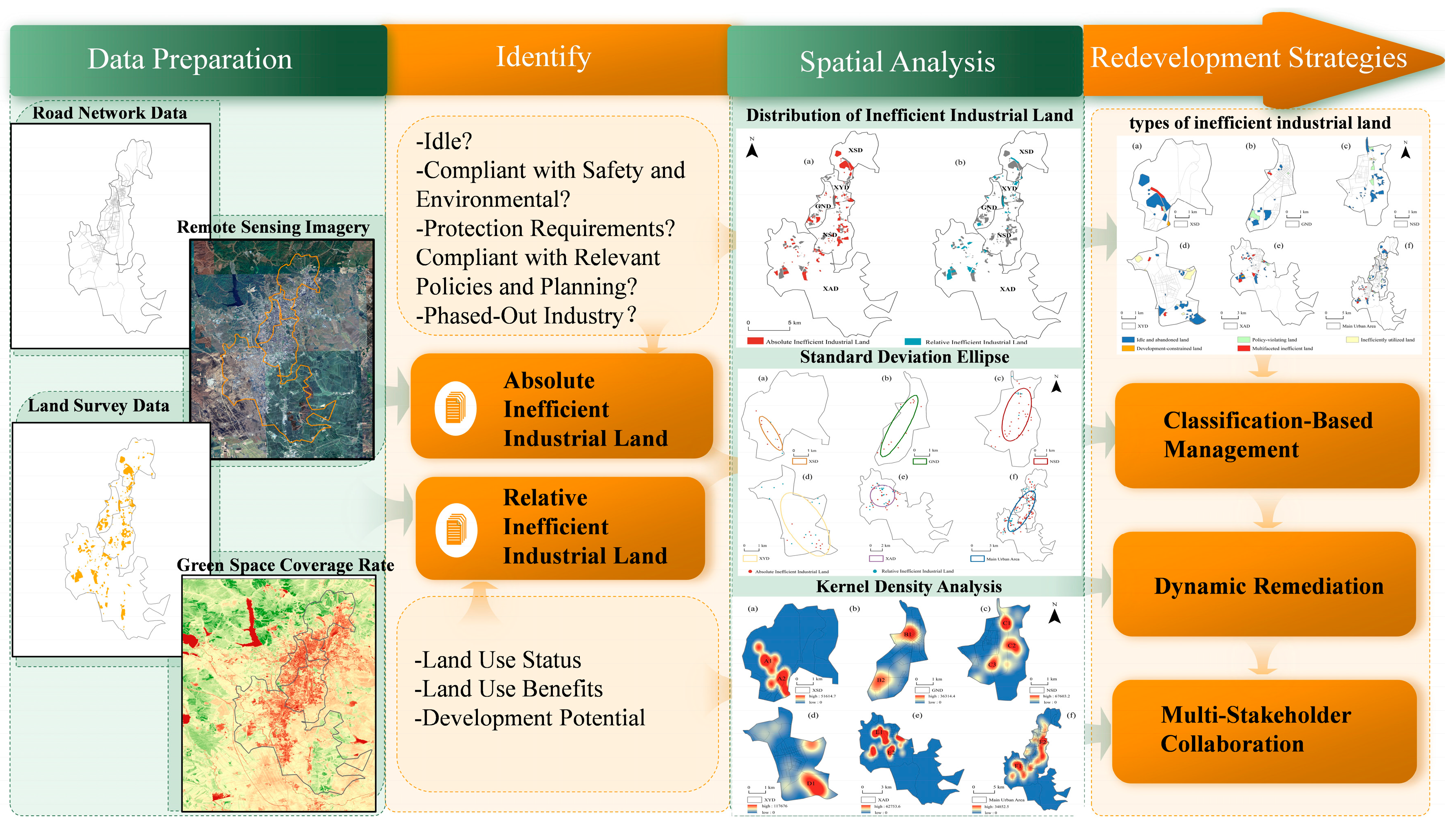
3. Materials and Methods

This study takes the main urban area of Hegang City as the empirical object and proposes a research framework for the identification and redevelopment of inefficient industrial land in resource-exhausted cities. By integrating multi-source data, an evaluation index system for inefficient industrial land is constructed, which includes land use status, land use efficiency, policy constraints, and development potential. The inefficient industrial land is identified through rigid exclusion and flexible evaluation methods. Based on the identification results, the scale type and spatial distribution characteristics are analyzed, and a redevelopment strategy of “classified governance–dynamic restoration–multi-stakeholder collaboration” is proposed. The research flowchart is shown in Figure 1.

3.1. Overview of the Study Area

Hegang City is located in the northeastern part of Heilongjiang Province, China, with geographical coordinates: 130°01′–131°34′ E, 47°03′–48°21′ N. It lies in the transitional zone between the Xiaoxing’an Mountains and the Sanjiang Plain. The city’s mining area began operations in 1917, with a coal mining history spanning over a century [36]. Cumulative proven coal reserves in Hegang City amount to 2.6 billion tons. As of 2024, the remaining recoverable reserves are less than 80 million tons. The city’s industrial production is mainly supported by coal, electricity, and chemical industries. According to public information, the output of industrial products in the city showed a downward trend in 2023, with raw coal and washed coal production decreasing by 2.5% and 10.9% respectively. Moreover, Hegang City is a typical shrinking city, which is reflected in the dual contraction of its economy and population. In terms of industrial economic benefits, the main business income of large-scale industrial enterprises in the city decreased by 20% year-on-year in 2023, and the total profit decreased by 1.18 billion yuan compared with the previous year. The city’s fixed asset investment decreased by 29.9% year-on-year, among which the investment in the secondary industry decreased by 21.7%. At the same time, the population loss in Hegang City is severe. The city’s registered population was 935,000 in 2023, a decrease of 159,100 compared with 2008, with an average annual population loss of 10,600. In terms of land use, compared with the data from the third national land survey in 2019 and the land change survey data in 2023, the area of mining land increased from 1280.9 hectares to 1731.77 hectares. It can be seen that the scale of industrial land use in Hegang City is still expanding, while the industrial economic benefits and output are gradually declining.
This study focuses on the main urban area of Hegang City, which encompasses five administrative districts: Xiangyang District, Gongnong District, Nanshan District, Xingshan District, and Xing’an District, with a total area of 205.5 km2 (Figure 2). The industrial land in the main urban area covers 13.2 km2, accounting for 10.8% of the construction land. The industrial land in the main urban area exhibits a “core-periphery” declining pattern. Xiangyang and Gongnong districts form the old industrial core area, while Xing’an district is an emerging industrial belt that started to expand after 2000. Additionally, along the Heyi Highway, there is a remaining corridor of the “coal mine-coal preparation plant-chemical plant” industrial chain, which connects four large-scale industrial and mining wastelands in the Nanshan and Gongnong districts. As the third batch of resource-exhausted cities in China, Hegang City has encountered several problems such as industrial structural imbalance and inefficient industrial land due to the depletion of coal resources. The evolution of the industrial space in its main urban area is of typical and urgent research value. There is an urgent need to explore the redevelopment of inefficient industrial land to revive the vitality and competitiveness of the urban area.

3.2. Data Sources

This research systematically collected and integrated multi-source heterogeneous datasets, including satellite remote sensing imagery, road network data, point of interest (POI) datasets, socioeconomic statistical indicators, industrial land vectors, and enterprise operation data (Table 1). Among them, industrial land vector parcels were constructed through the following technical processes: (1) Obtained industrial enterprise directories and spatial location information from the Tianyancha enterprise information platform; (2) Acquired coordinates in the BD-09 coordinate system using Baidu Maps API geocoding services; (3) Converted them to the WGS 1984 geographic coordinate system using ArcGIS 10.8 spatial reference conversion tools; (4) Registered to a unified spatial reference system through projection transformation; (5) Verified and corrected using Chinese Third National Land Survey results data.
Considering the timeliness of data updates and the research’s temporal relevance, this study selected data from 2020 to 2024. Road network data, remote sensing imagery, point of interest (POI) datasets, and industrial land vector data can reflect the relatively stable spatial structure and functional layout of the city. In contrast, socioeconomic statistical data focuses on capturing the city’s dynamic development and economic benefits, requiring timely updates. According to the urban health check report in Hegang’s latest round of territorial spatial planning, there have been no significant changes in the city’s spatial pattern in recent years, and its overall urban scale has remained stable. Therefore, selecting data from 2020 to 2024 is reasonable, and the accuracy and scientific validity of the data will not be significantly affected.

3.3. Methods for Calculating Index Weights

3.3.1. Construction of Evaluation Index System

According to the multi-dimensional characteristics of industrial land decline in resource-exhausted cities and following the four-dimensional analytical framework of “land use status-land use efficiency-policy constraints-development potential”, this study constructs an evaluation index system of inefficient industrial land at the parcel level (Table 2). Additionally, a dual-path judgment framework of “rigid exclusion + flexible evaluation” is established. Precise identification of inefficient industrial land is achieved by using rigid constraint indicators and flexible evaluation indicators, which avoids misjudgments resulting from irrational index weight distributions in traditional models. Rigid constraint indicators, which define non-negotiable thresholds for industrial land use, necessitate the classification of parcels violating any mandatory criteria as inefficient land. These include plots with critical safety, environmental, or planning violations, which are prioritized for elimination as “absolutely inefficient” land. The remaining plots undergo multi-dimensional efficiency ranking through a flexible evaluation indicator system, focusing on “relatively inefficient” land [37,38].
The construction of the indicator system is centered on “the transformation demands of resource-exhausted cities.” By synthesizing theories from multiple disciplines, including land economics and urban ecology, a four-dimensional framework has been developed. This framework encompasses “current situation diagnosis, efficiency assessment, bottom-line constraints, and potential prediction,” diverging from the conventional economic indicators typically adopted by general cities. The screening of indicators is guided by the principles of scientificity, operability, and spatial heterogeneity. By referencing documents such as the “Catalogue for the Guidance of Industrial Structure Adjustment” (2024) and the “Control Indicators for Industrial Project Construction Land” (2023), a systematic framework consisting of 4 criterion layers and 13 indicator layers has been established.
As an important spatial observation dimension, the land use status indicator (B1), based on the cross-disciplinary perspective of land economics and urban geography, can precisely capture the spatial manifestation of industrial decline in resource-exhausted cities. It reflects the current usage of industrial land and is often influenced by social, economic, and spatial development factors [5]. Four indicators, namely floor area ratio, benchmark land price, green space coverage rate, and idle status, are selected to represent the overall land use situation. The floor area ratio indicator reflects the spatial development intensity of industrial land and is a core metric for measuring the intensive use of land. The benchmark land price comprehensively reflects the location conditions and represents the average price level of industrial land, which can quantify the “degradation of location advantages” caused by the single industrial structure in resource-exhausted cities. The green space coverage rate indicator aims to dynamically balance land use efficiency and ecological sustainability, avoiding resource misallocation. It is particularly crucial for resource-exhausted cities facing dual pressures of ecological crisis and the need for intensive land use. The idle status is used to determine whether industrial land is in a state of production suspension, construction suspension, abandonment, or long-term vacancy, and it is a core rigid indicator for identifying “absolutely inefficient land”, which can reflect the typical feature of large-scale land idleness caused by resource exhaustion. Land use efficiency (B2) is an important indicator for measuring the utilization efficiency and comprehensive value of land resources. It reflects the economic, ecological, and social benefits generated during the process of industrial land use. Three indicators, namely the average number of employed people per unit of land, the average fixed asset investment per unit of land, and the degree of environmental pollution are selected for evaluation. Among them, the average employment per unit area can measure the industrial support capacity, reflecting the social benefits and industrial vitality of land use, and is used to represent the decline in the employment capacity per unit of industrial land in resource-exhausted cities due to population outflow and industrial decline. The average fixed asset investment per unit area can reflect the economic intensity and investment attractiveness of land use and is used to evaluate the economic benefits of such cities under the “resource curse” effect. Given the characteristics of resource-exhausted cities with a high proportion of high-pollution sites and prominent ecological risks of land use, the environmental pollution degree index can precisely quantify their ecological benefits. Policy constraints (B3) are used to assess whether a plot complies with relevant policy plans, safety production, and environmental protection requirements. Two indicators are selected: whether it conforms to relevant policies and plans, and whether it meets safety production and environmental protection requirements. The development potential (B4) focuses on the continuous growth capacity of enterprises, the space for technological upgrading, and the compatibility with industries. Four indicators are selected to represent the development potential of industrial land: the number of patents, the degree of suitability for development in terms of location, the industrial category, and whether it belongs to an industry to be phased out. The indicator of the number of patents aims at the pain point of “anemia of innovation capacity” in resource-exhausted cities, screening out plots with potential for technological upgrading. The indicator of the degree of suitability for development in terms of location addresses the problem of solidified spatial structure in resource-exhausted cities, dividing locations into core areas, peripheral areas, and industrial parks. The industrial category indicator incorporates the “resource industry life cycle” theory and, based on the “Guidance Catalogue for Industrial Structure Adjustment”, distinguishes between restricted and phased-out industries.

3.3.2. Data Standardization Processing

To eliminate dimensional differences and directional effects among multiple indicators, this study employs the range standardization method for raw data normalization. Evaluation indicators are classified into positive indicators (higher values indicate, higher land use efficiency) and negative indicators (higher values indicate, lower land use efficiency) based on their directional impact on land use efficiency. The following formulas are used for processing:
Positive indicator standardization formula:
x i j = x i j m i n x j m a x x j m i n x j
Negative indicator standardization formula:
x i j = m a x x j x i j m a x x j m i n x j
where:   x i j is the original value of the j th indicator for the i th sample, m a x x j ,   m i n x j are the maximum and minimum values of the jth indicator, x i j is the standardized indicator value, with a range of [0, 1].

3.3.3. Determination of Index Weights

In various evaluations of mathematical and physical methods, determining the weights of indicators is a crucial step [39]. Due to the uncertainty between urban industrial land efficiency and evaluation indicators, weight determination methods can be classified into subjective and objective approaches. The commonly used objective weighting methods mainly include the entropy method, principal component analysis, and factor analysis [40,41,42,43], while the commonly used subjective weighting methods mainly consist of the Analytic Hierarchy Process (AHP) and the Delphi method. The results of the subjective assignment method are easily influenced by subjective judgments, while the results of the objective assignment method are more affected by the data itself. Therefore, it is more scientific to adopt a method that combines subjective and objective approaches. This study combines the Analytic Hierarchy Process (AHP) with the Entropy Method and adopts the game theory-based combined weighting method to determine the index weights [44], enabling the results to reflect both the subjective experience of experts and the respect for the objective data patterns. The fundamental idea of the game theory combination weight is to find the consistency and compromise for different weights of a certain evaluation index and minimize the deviation between the possible weights and each basic weight. The main steps are as follows:
(1) Employ L methods to determine the weights of n indicators
w l = ( w l 1 , w l 2 , , w l n ) ,   l = 1,2 , , L
Then, the linear combination of L weight vectors can be expressed as:
w = l = 1 L α l w l T ( α l > 0 )
where w denotes the combined weight vector and α l denotes the linear combination coefficient.
(2) Based on the game theory-based combination principle, minimize the deviation between w and α l . The objective function is:
min l = 1 L α l w l T w p T 2 , p = 1,2 , , L
(3) Based on the properties of matrix differentiation, the first-order optimality conditions for the above equation are as follows:
l = 1 L α l w p w l T = w p w p T , p = 1,2 , , L
The linear system of equations equivalent to the above equation is:
w 1 w 1 T w 1 w 2 T w 1 w L T w 2 w 1 T w 2 w 2 T w 2 w L T w L w 1 T w L w 2 T w L w L T α 1 α 2 α L = w 1 w 1 T w 2 w 2 T w L w L T
(4) Solve the linear system of equations derived above to obtain optimized combination coefficients, which are then normalized. Given the potential presence of negative values in the optimized combination coefficients, absolute values must be computed before normalization.
α l * = | α l | / l = 1 L | α l |
(5) Calculate the combined weight.
w * = l = 1 L α l * w l T ,     l = 1,2 , , L

3.3.4. Determination of Evaluation Model

First, absolute inefficient industrial land is preliminarily identified using rigid constraint indicators. If a parcel violates any rigid constraint indicator, it is directly classified as inefficient land. For the remaining parcels, industrial land use efficiency is evaluated using the following formula. Evaluation results are divided into four grades by the natural breaks method, from highest to lowest: high efficiency, moderate efficiency, general inefficiency, and severe inefficiency.
E = i = 1 n S i W i
where E denotes the industrial land use efficiency, S i denotes the score of the i th indicator in relative indicators, and W i denotes the weight of the i th indicator in relative indicators.

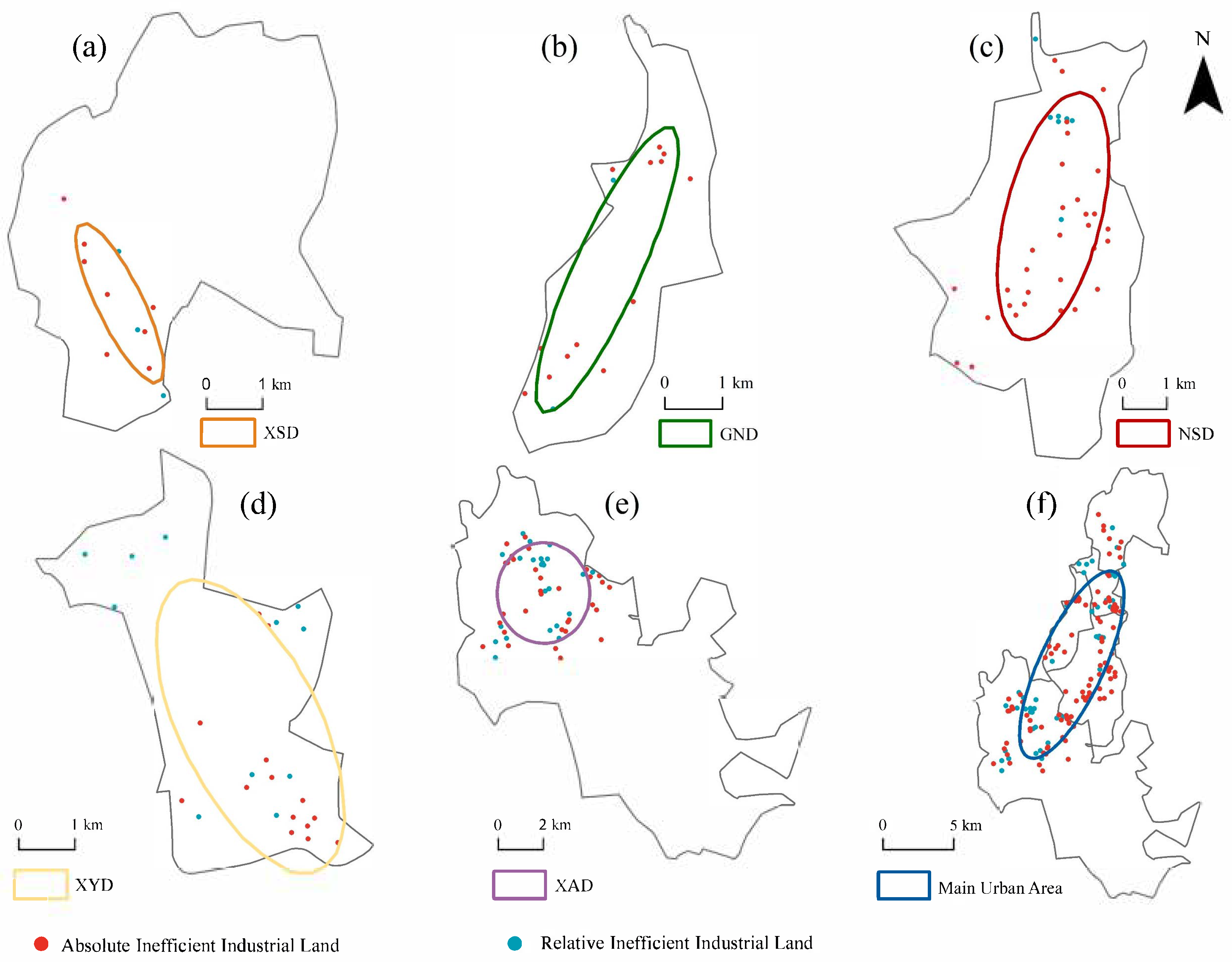
3.4. Spatial Feature Research Methods

Using standard deviational ellipse and kernel density analysis, the spatial pattern of inefficient industrial land in the main urban area of Hegang City is analyzed from multiple dimensions: distribution range, positional relationships, directional characteristics, and agglomeration morphological characteristics.

3.4.1. Standard Deviational Ellipse Method

The Standard Deviational Ellipse (SDE) is a geostatistical method based on spatial analysis. It quantifies the spatial distribution characteristics of geographic features to reveal their overall distribution trend, direction, and degree of dispersion. In this study, the SDE is applied to analyze the spatial distribution pattern of industrial land in the main urban area of Hegang City. The specific calculation process is as follows:
(1) Determine the spatial distribution centroid of industrial land X , Y to represent the equilibrium center of spatial distribution:
X = i = 1 n w i x i i = 1 n w i , Y = i = 1 n w i y i i = 1 n w i
where: x i , y i   is the geometric center coordinate of the i th land parcel, w i represents the area-weighted factor.
(2) Azimuth Determination: Using true north as the reference, calculate the principal axis direction of the ellipse to reveal the spatial extension trend:
t a n θ = A + B C
where:
A = i = 1 n w i x ~ i 2 i = 1 n w i y ~ i 2
B = i = 1 n w i x ~ i 2 i = 1 n w i y ~ i 2 2 + 4 i = 1 n w i x ~ i y ~ i 2
C = 2 i = 1 n w i x ~ i y ~ i
(3) Calculate the standard deviations of the major axis σ x and minor axis σ y of the ellipse to quantify the degree of spatial dispersion:
σ x = i = 1 n w i x ~ i c o s θ w i y ~ i s i n θ 2 i = 1 n w i 2 , σ y = i = 1 n w i x ~ i s i n θ + w i y ~ i c o s θ 2 i = 1 n w i 2

3.4.2. Kernel Density Analysis

Kernel Density Estimation (KDE) is a spatial analysis technique based on point or polygon data, commonly used to reveal the spatial distribution density characteristics of geographic features. By converting discrete data points into continuous density surfaces, it visually displays the agglomeration degree and spatial distribution pattern of features. In this study, KDE is applied to analyze industrial land in the main urban area of Hegang City, aiming to accurately grasp the agglomeration status of industrial land in urban space.
D = 3 1 s c a l e 2 2 π r 2
where: r is the search radius, s c a l e represents the ratio of the distance from point/line objects to the grid center divided by the search radius.

3.5. Methods for Classifying Inefficient Types

To accurately diagnose problems, analyze the root causes of inefficiency, and formulate differentiated redevelopment strategies, this study subdivides inefficient industrial land into the following categories after identification. Unclassified parcels are manually reviewed and labeled. The types of inefficient industrial land are shown in Table 3.
(1)
Idle and abandoned land (B1-Dominant): Evaluates industrial land inefficiency from the perspective of operational continuity. Key indicators include land vacancy status, plot ratio, benchmark land price, and green space coverage rate.
(2)
Inefficiently utilized land (B2-Dominant): Examines industrial land inefficiency from the perspective of land use performance. Key indicators include employment per unit land area, fixed asset investment intensity, and environmental pollution level.
(3)
Policy-violating land (B3-Dominant): Identifies inefficient land based on compliance with development regulations, policies, and requirements during the utilization process. Key indicators include compliance with safety/environmental standards, compliance with industrial policies/plans, and status as a phased-out industry.
(4)
Development-constrained land (B4-Dominant): Measures industrial land inefficiency from the perspective of redevelopment potential. Key indicators include number of patents held, locational suitability for development, and industrial categories.
(5)
Multifaceted inefficient land: Simultaneously meets two or more of the above categories.
Table 3. Classification criteria and judgment rules.
Type of Inefficient Industrial LandCore Evaluation CriteriaCorresponding Indicator Performance
Idle and abandoned typeLong-term undeveloped or extremely low utilization rate- Floor Area Ratio (FAR) <0.3
- Standardized benchmark land price <0.3 or >0.8
- Green space coverage <10% or >20%
Inefficiently utilized typeTriple Low-efficiency (Economic-Ecological-Social)- Fixed asset investment < 20% below the municipal average
- Employment density per unit land area < 50% of the regional average
- Environmental pollution level ≥ Grade 3
Policy-violating typeViolations of environmental or land-use policies- Non-compliance with relevant policies and planning regulations
- Failure to meet safety production standards and environmental compliance requirements
Development-constrained type Significantly inadequate future development potential- Number of patents held ≤ 1
- Locational suitability grade = 3
- Industrial category classification = 1
Multifaceted inefficient typeMulti-dimensional inefficiency with extremely low composite score- Meet two or more of the other four types

3.6. Accuracy Evaluation Method of Recognition Results

To assess the reliability of the proposed model, this study, referring to Jin R’s research, took 144 inefficient industrial land parcels in the main urban area of Hegang City as the research objects and conducted empirical tests by combining stratified random sampling with on-site verification [8]. Firstly, based on the distribution of inefficient land use types, with a 95% confidence level and a 5% allowable error rate as the benchmark, 40 samples were selected through proportional allocation stratified sampling to ensure that the samples covered all types and were spatially distributed evenly. The verification process relies on publicly available information such as policies and plans of Hegang City, refers to the recognition standards and control indicators for inefficient industrial land in pilot cities, and combines satellite remote sensing interpretation and on-site investigation to verify the actual inefficient types of the sample plots. Among them, for the idle and abandoned type, it is necessary to meet the condition that the production has been suspended or semi-suspended for more than two years without generating main business profits. For the policy-violating type, it is necessary to determine whether it belongs to the category of industries to be phased out as per the industrial policy or whether it complies with the requirements of safety production and environmental protection. For the inefficiently utilized type, it is necessary to verify whether its plot ratio and building coefficient meet the control values stipulated for each industry in the “Control Indicators”. For the development-constrained type, it is necessary to verify its economic benefits indicators such as fixed asset investment intensity, land output rate, and tax.
The confusion matrix is a classic tool for evaluating the performance of classification models. By cross-comparing the model’s predicted results with the actual observed values, it visually presents the classification accuracy among various categories. The rows of the matrix represent the true categories, and the columns represent the predicted categories. The diagonal elements are the numbers of correctly classified cases, while the non-diagonal elements are the numbers of misclassified cases. In this study, the confusion matrix was used to statistically analyze the matching situation between the model-predicted types and the field-verified types of inefficient industrial land in Hegang City.
The Kappa coefficient is a statistical measure for evaluating the consistency of classification results, used to correct the potential bias in accuracy due to random coincidence. Its value range is [−1, 1]. The closer the Kappa coefficient is to 1, the stronger the consistency between the model’s prediction and the actual result. Its calculation formula is:
K a p p a = P o P e 1 P e

4. Results and Analysis

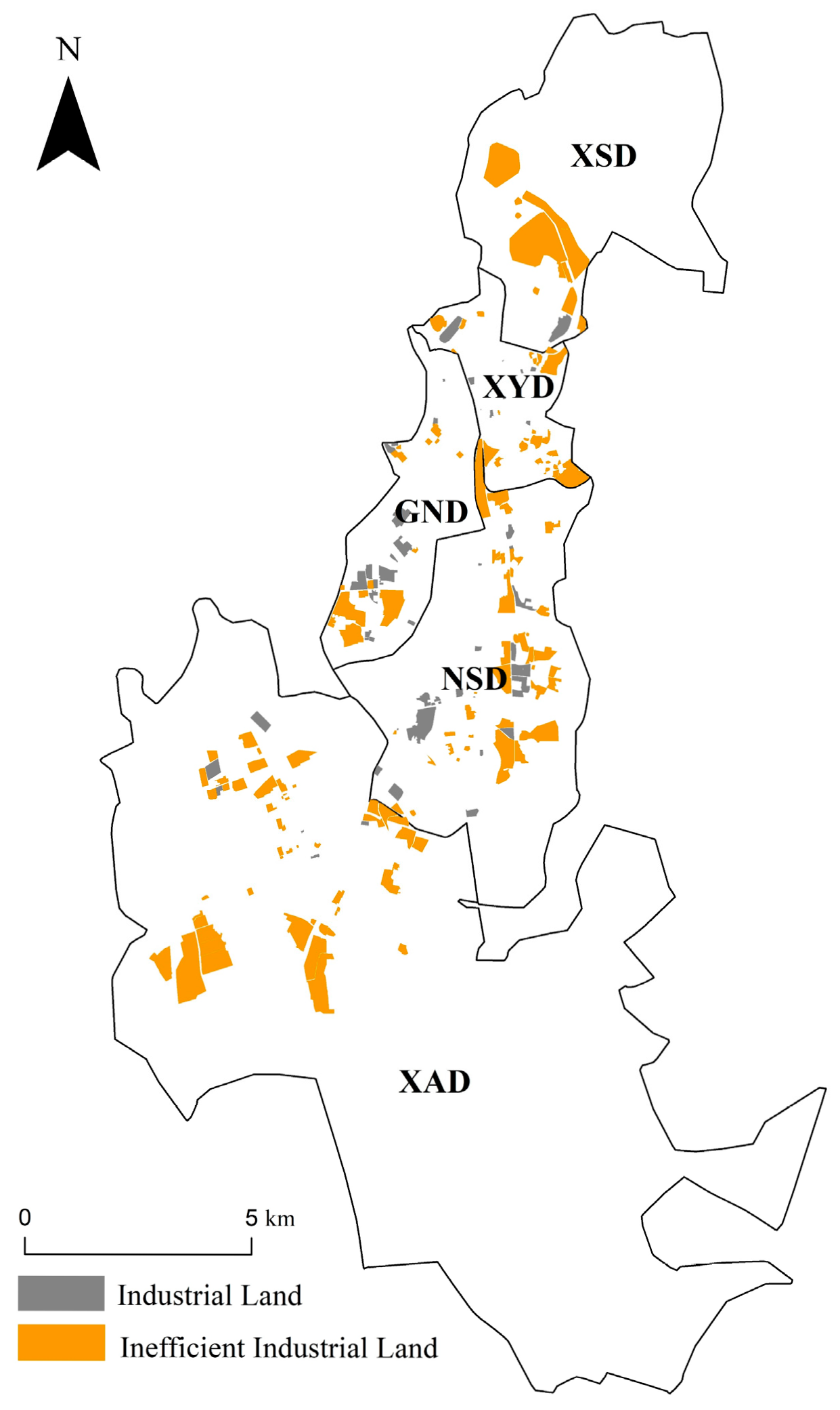
4.1. Identification of Inefficient Industrial Land

4.1.1. Identification of Absolute Inefficient Industrial Land

Figure 3 and Table 4 illustrate the spatial distribution, quantity, and area characteristics of inefficient industrial land. At the main urban area scale, 98 absolute inefficient industrial land parcels were identified, covering 7.63 km2 and accounting for 69.3% of the total inefficient industrial land area. These parcels exhibit a fragmented scattered pattern, distributed as isolated patches across the five districts without forming contiguous large-scale clusters. Regionally, absolute inefficient industrial land is primarily concentrated in Xing’an District, with 32 parcels covering 2.21 km2 (28.96% of the total absolute inefficient industrial land area). This is followed by Xingshan District and Nanshan District, with 8 and 31 absolute inefficient parcels accounting for 27.65% and 26.34% of the total, respectively. Located in central Hegang, Xiangyang District and Gongnong District contain 14 and 13 absolute inefficient parcels, covering 0.53 km2 and 0.77 km2 with small patch sizes. Notably, absolute inefficient industrial land in Xingshan District forms small-scale agglomerations centered on coal mining companies. Despite having the fewest parcels, its average parcel area of 0.26 km2 ranks among the largest, indicating large patch sizes. Other regions exhibit “dot-like” inefficiencies with small, scattered patches that lack systematic clustering.

4.1.2. Identification of Relative Inefficient Industrial Land

After calculating parcel composite scores using the industrial land use efficiency evaluation model in Formula (10), results were categorized into four grades via the natural break method in ArcGIS 10.8. The results showed 16 parcels of high-efficiency land, 43 parcels of moderate-efficiency land, 41 parcels of general inefficiency land, and 5 parcels of severe inefficiency land. Table 4 shows that the main urban area of Hegang contains 46 parcels of relatively inefficient industrial land, covering 3.38 km2 (30.7% of total inefficient industrial land area and 25.6% of total industrial land area). In terms of overall spatial pattern, relatively inefficient industrial land exhibits a decentralized distribution, fragmented across multiple districts including Xingshan, Nanshan, and Xing’an without forming large-scale contiguous clusters. At the local scale, small-scale agglomerations occur in southern Nanshan and southern Xing’an Districts, demonstrating a pattern of “overall dispersion with localized agglomeration.” Specifically, Xing’an District contains the largest number of relatively inefficient industrial land parcels ([23]) and the largest area (1.97 km2), serving as the core region for such land use in the study area and accounting for 58.28% of the total relatively inefficient land area. Inefficiencies in other districts are relatively mild, with all inefficient land parcels covering less than 1 km2 and fewer in quantity, primarily consisting of isolated industrial patches. Furthermore, compared to absolute inefficient industrial land, relatively inefficient industrial land in all districts is significantly fewer in both quantity and area, with Xingshan and Nanshan Districts showing the most prominent differences.

4.2. Spatial Distribution Characteristics of Inefficient Industrial Land

Combining Figure 4 and Table 4 shows significant spatial disparities in inefficient industrial land distribution across administrative districts. In terms of total statistics, Xing’an District emerged as the most concentrated area with 55 parcels (4.18 km2), accounting for 37.97% of the city’s total inefficient industrial land. Nanshan District followed with 38 parcels (2.44 km2), forming a “dual-core “distribution area with Xing’an District. In contrast, Xiangyang, Gongnong, and Xingshan Districts exhibited smaller-scale inefficiencies. Spatially, inefficient industrial land displayed a composite pattern of “overall dispersion with localized agglomeration.” At the main urban area scale, inefficient industrial land was fragmented across Xingshan, Xiangyang, Gongnong, Nanshan, and Xing’an Districts without forming contiguous clusters. Locally, small-scale agglomerations occurred in traditional industrial areas such as Xing’an and Nanshan Districts. Significant variations in parcel size were observed across districts. Xingshan District had the largest average parcel size (0.22 km2), indicating dominance by large-scale industrial plots. Conversely, Xiangyang District—due to mixed land uses in the city center—exhibited fragmented inefficiencies with small parcel sizes (0.04 km2) and high quantity.

4.2.1. Spatial Location and Directional Characteristics of Inefficient Industrial Land

This study utilized ArcGIS 10.8 to convert inefficient industrial land polygons into point feature data using vector polygon-to-point conversion. Standard Deviational Ellipse analysis was employed to quantify directional distribution characteristics of inefficient industrial land across districts. Visual analysis results are shown in Figure 5, with ellipse parameters detailed in Table 5.
Spatially, inefficient industrial land in Hegang’s main urban area exhibited characteristics of overall dispersion with localized agglomeration. Table 5 reveals minimal differences in distribution center coordinates across districts, indicating strong spatial concentration without significant cross-district dispersion. Additionally, the main urban area’s Standard Deviational Ellipse area (51.80 km2) was significantly larger than individual districts, reflecting extensive spatial coverage and high dispersal. Specifically, larger ellipse areas in Xing’an and Nanshan Districts indicated broader distribution and higher dispersal. Conversely, smaller ellipse areas in Xingshan and Xiangyang Districts suggested concentrated distributions with low dispersal and relatively clustered patterns. Directionally, districts displayed diverse orientations. Gongnong District had a rotation angle of 36.08°, and Nanshan District 25.36°, collectively oriented northeast-southwest. Xingshan and Xiangyang Districts had rotation angles approaching 135°, indicating their primary distribution direction leaned northwest-southeast. X- and Y-axis parameters revealed longer Y-axes for the main urban area, indicating greater north-south dispersal than east-west. This pattern was echoed in Gongnong and Nanshan Districts, confirming broader north-south spatial extension.

4.2.2. Agglomeration Patterns of Inefficient Industrial Land

Kernel density analysis maps revealed prominent multi-centered agglomeration patterns of inefficient industrial land in Hegang’s main urban area, characterized by a “multi-centered, scattered” clustering configuration (Figure 6). Specifically, each district exhibited multiple high-value clusters rather than single centralized distributions. High-value clusters extended across the main urban space, forming numerous linear or massive high-density agglomeration belts. This reflects the composite characteristics of localized clustering at the micro-district scale and continuous distribution at the macro-urban scale for inefficient industrial land. Xiangyang District displayed significantly higher kernel density values with highly concentrated inefficient industrial land, while Nanshan District had relatively lower density and weaker clustering intensity, featuring small-scale scattered agglomerations. When combined with road networks, high-density areas aligned with road orientations, distributed linearly along He-Yi Highway, National Road G201, and Provincial Road S101 (F1, F2). However, these areas were mostly located in low-density road networks or non-core urban functional zones, spatially mismatched with residential and commercial centers—a phenomenon attributed to industries’ reliance on transportation accessibility. Xingshan District’s clusters centered near Jiachen Coal Washing Group on Changzheng Road (A1, A2). Gongnong District’s agglomeration centers exhibit a dual-core pattern, primarily located at the intersections of Baiguan Street and Qingnian Road, as well as Gongnong Road and Shengli Road (B1, B2). Nanshan District displayed a “multi-core” model along Fuli Road and Nangang Road (C1, C2, C3). Xiangyang District’s inefficient industrial land is concentrated near the intersection of Nanyi Road and Xigang Street (D1). Agglomeration centers in the Xing’an District were situated along the He-Da Line and He-Yi Highway(E1, E2).

4.3. Classification of Inefficient Types

Figure 7 and Table 6 illustrate the spatial distribution of urban inefficient industrial land types in the study area. Xing’an District contains 55 inefficient industrial land parcels, primarily idle and abandoned land. This category includes 41 parcels spanning 2.52 km2, accounting for 60.3% of the district’s total inefficient land. Additionally, there are 9 parcels of multifaceted inefficient land covering 1.24 km2, 3 policy-violating land parcels totaling 0.25 km2, and 2 development-constrained land parcels spanning 0.17 km2. As a traditional coal industrial cluster affected by resource depletion, Xingshan District’s inefficient industrial land is dominated by idle and abandoned land (85.1% of the area), with limited other types. Among Xiangyang District’s 25 inefficient parcels, 17 are idle and abandoned land covering 0.60 km2, representing 61.9% of the district’s inefficient land area. The presence of inefficiently utilized and multifaceted land indicates both idleness and underperformance issues. Gongnong District’s 15 inefficient parcels include 12 idle and abandoned land parcels spanning 0.66 km2, accounting for 66% of the district’s total. Additionally, there are 2 policy-violating land parcels totaling 0.29 km2 and 1 multifaceted inefficient land parcel covering 0.05 km2. Nanshan District has 38 inefficient parcels, with 75% classified as idle and abandoned land. Other types include 5 inefficiently utilized land parcels covering 0.11 km2, 4 policy-violating land parcels totaling 0.49 km2, and 1 multifaceted inefficient land parcel spanning 0.01 km2.
Overall, among the 144 inefficient industrial land parcels in the study area, 105 (7.67 km2) are idle and abandoned land. This category accounts for 72.9% of total parcels and 69.7% of the total area, making it the dominant inefficient type in Hegang’s main urban area. In terms of distribution, idle and abandoned land is most extensive in Xing’an District (32.9% of the total), followed by Xingshan and Nanshan Districts (26.9% and 23.9% respectively). Urban core areas primarily feature idle/abandoned and policy-violating land with limited other types. Conversely, urban fringe areas exhibit higher diversity, including idle/abandoned land alongside inefficiently utilized, development-constrained, and multifaceted inefficient land.

4.4. Accuracy Evaluation Results

To ensure that the samples cover all types of low-efficiency and reflect the overall distribution characteristics, this study randomly selected 40 cases of inefficient industrial land for accuracy verification. These include 27 cases of idle and abandoned type, 3 cases of policy-violating type, 3 cases of inefficiently utilized type, 3 cases of development-constrained type, and 4 cases of multifaceted inefficient type.
Based on the verification results, a confusion matrix was constructed to calculate the model accuracy and Kappa coefficient (Table 7). The results show that the model recognition accuracy reached 87.5%, and the Kappa coefficient was 0.785. This not only indicates that the evaluation results of this study are highly consistent with the actual situation but also confirms that the evaluation model proposed in this study is scientifically valid. However, since there is no officially released standard for identifying low-efficiency land in Hegang, the verification rules are based on academic derivation and need to be adjusted in combination with future policies. Figure 8 shows eight typical plots of each inefficient type in the study area.

5. Discussion

5.1. Spatial Analysis of Urban Inefficient Industrial Land

The spatial distribution characteristics of inefficient industrial land in Hegang’s main urban area profoundly reflect the complex contradictions in industrial transformation and land use of resource-exhausted cities. Based on multidimensional spatial analysis, this study finds that its spatial pattern presents a compound feature of “overall dispersion and local concentration”, with idle and abandoned types being dominant, and significant regional differences.
In terms of distribution, inefficient industrial land is mainly concentrated in Xing’an District and Nanshan District. The core reason for this outcome is the historical industrial layout and the lagging industrial transformation, which is similar to the research results of Wu K [44]. In other areas such as Xiangyang District and Gongnong District, due to their location in the urban core area, they are squeezed by commercial and residential functions, resulting in fragmented industrial land with the characteristics of “many in number but small in scale”, reflecting the contradiction and conflict between the functional renewal of the urban center and the process of industrial land withdrawal [24]. In terms of spatial orientation, the dispersion degree of inefficient industrial land in the main urban area shows a feature of “higher in the north-south direction than in the east-west direction”. The cause of this phenomenon is closely related to the north-south extending transportation arteries in Hegang City. Essentially, it is the spatial reflection of the “transportation priority” location logic of industrial land [5,45]. From the perspective of agglomeration patterns, the inefficient industrial land in the main urban area presents a “multi-centered and scattered” agglomeration pattern. The high-density areas are concentrated in the traditional industrial corridors and form a significant spatial mismatch with residential and commercial centers. The essence of this phenomenon is the temporal mismatch between urban development and industrial transformation. This is in line with the views proposed by Swiss scholar Rey [10,16]. Furthermore, the lagging nature of policies and management mechanisms has further solidified the inefficient land use pattern [46]. Traditional industrial zones are difficult to revitalize due to the lack of re-development incentive policies and industrial exit mechanisms, and fragmented plots are subject to “inefficiency lock-in” due to high management costs [47]. Notably, as the process of resource depletion deepens, the types of inefficient land use are undergoing structural changes. On the one hand, the proportion of idle and abandoned land solely due to enterprise closures may decline; on the other hand, the share of multifaceted inefficient land caused by functional conflicts, environmental constraints, or failed industrial transformation may increase. Moreover, due to weaker planning control, the urban fringe areas may become high-incidence regions for low-benefit and under-potential land use.
In conclusion, the spatial pattern of inefficient industrial land in Hegang is the result of the combined effects of resource endowment, transportation orientation, urban shrinkage, and institutional constraints. Therefore, differentiating the types and formulating targeted redevelopment strategies is a key entry point for resource-exhausted cities to break the predicament of land inefficiency and achieve spatial restructuring [48].

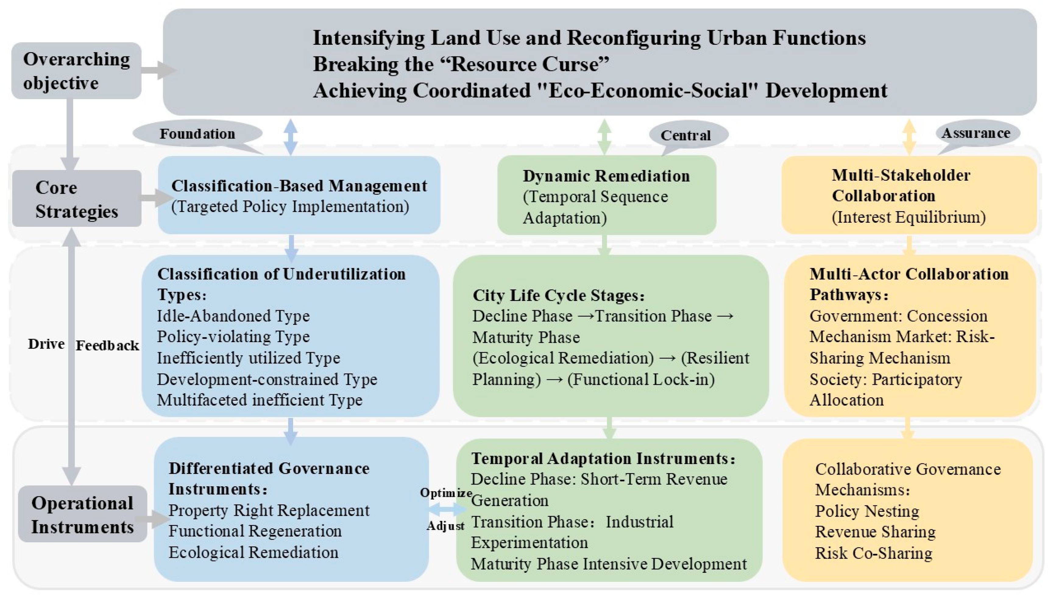
5.2. Innovation and Adaptability of Redevelopment Strategies

The transformation of resource-exhausted cities is a significant issue in the economic and social development of countries around the world. If we can draw on Western experience and combine it with China’s objective reality, this problem can surely be effectively solved [15,49]. Based on the actual situation of Hegang City, this study constructs a strategy framework of “classified governance-dynamic restoration-multi-stakeholder collaboration” (Figure 9). Built on inefficient type classification, this framework adapts to dynamic urban life cycle needs through differentiated property rights restructuring, functional replacement, and ecological restoration pathways. It balances multiple interests via multi-stakeholder collaborative governance.

5.2.1. Classified Governance Strategy

The differentiation of types of inefficient industrial land determines the differentiation and precision of governance tools. Categorized control can effectively avoid the failure of governance caused by the “one-size-fits-all” approach through “one policy for one type” [50].
Idle and abandoned land accounts for the highest proportion of inefficient industrial land in Hegang City, mostly located in the old industrial areas with exhausted resources. These areas are adjacent to transportation hubs and have abundant land resources, but they are mainly state-owned allocated land with complex property rights and high ecological restoration costs [48]. Based on the “property rights economic theory” and the “brownfield regeneration theory”, the governance dilemma needs to be resolved through property rights restructuring and ecological compensation mechanisms [51].
There are a total of 10 policy-violating inefficient industrial land plots. Among them, 9 are caused by non-compliance with safety production and environmental protection requirements, mainly distributed in the coal mines, coal preparation plants, and their surrounding areas in Nanshan District and Xing’an District. The severe pollution emissions and the continuous expansion of the subsidence areas caused by coal mining have jointly led to irreversible ecological damage. At the same time, problems such as aging equipment and incomplete safety protection facilities are prominent. For the redevelopment of such land, safety production and environmental protection compliance should be the core, and on this basis, promote industrial transformation and technological innovation.
There are a total of 11 inefficiently utilized industrial land plots, all located in the urban fringe. These plots have problems such as scattered spatial layouts and low industrial energy efficiency. The redevelopment can adopt a comprehensive strategy of “space integration + industrial upgrading + ecological governance”. Taking the integration of land throughout the region as the starting point, scattered plots can be developed in a concentrated and contiguous manner to enhance the value of the land’s multi-functional use. Industries such as mining and metal products manufacturing, which are highly polluting and have low added value, should be guided to exit. At the same time, ecological restoration should be carried out on polluted plots to create a sustainable development demonstration area featuring intensive land use, low-carbon industrial circulation, and enhanced environmental resilience [52].
There are a total of three development-constrained land plots in the study area. Although they are few in number, they still need to be given attention and appropriate control measures should be taken in advance. These plots are located on the periphery of major transportation routes and have poor development potential, with a risk of becoming idle and abandoned industrial land. Based on location theory and the TOD development model [53,54], low-traffic-dependent industries can be introduced, and logistics hubs or economic development zones can be planned along the main roads, with dedicated railway lines provided to enhance the accessibility and economic radiation capacity of the plots.
There are a total of 15 multifaceted inefficient land plots, which are mostly located in the transitional zone between old industrial areas and the urban periphery. These plots are entangled with various problems and require multi-dimensional collaborative governance. By establishing a three-dimensional evaluation system and conducting a cross-analysis of four types of indicators, namely land use conditions, land use efficiency, policy constraints, and development potential, the dominant contradictions leading to inefficiency can be identified. Based on their significance, appropriate redevelopment strategies can be selected.

5.2.2. Dynamic Restoration Mechanism

The redevelopment of resource-exhausted cities should be dynamically adapted to the stage of industrial transformation. Unlike the post-industrial background of brownfield governance in Europe and America, Hegang City is in a special stage of transition from the middle to the later period of industrialization, and targeted policies need to be implemented. Establishing a dynamic restoration mechanism can effectively match the urban life cycle. By adjusting policy tools in sequence, it can achieve an elastic balance between land supply and industrial demand.
During the depletion period, the focus of redevelopment should be on ecological restoration and temporary utilization. Priority should be given to the graded management of severely polluted plots and the restoration of the mine environment. When the industrial direction is unclear, low-cost temporary utilization should be adopted to maintain the economic value of the land and avoid the secondary waste of “restoration and then idleness” [17]. During the transformation stage, flexible planning and mixed land use policies should be implemented [55]. Industrial land should be allowed to be compatible with research and development and warehousing functions, and through policy tools such as tax reduction and exemption, the high-quality development of emerging industries should be promoted. This combination strategy of functional mixing and policy relaxation not only provides space for industrial trial and error but also effectively adapts to the uncertainties of the transformation period. In the mature stage, attention should be paid to functional locking and land intensification to meet the development needs of specialization and clustering in the mature stage. Relying on the provincial high-tech development zone, the two leading industries of graphite new materials and biomedicine should be cultivated. A graphite deep processing industrial park should be built to form a full-chain layout from graphite to lithium batteries.
The dynamic restoration mechanism can integrate short-term restoration with long-term transformation [56], responding to the nonlinear characteristics of the life cycle of resource-based cities through the sequential progression of “ecological restoration → resilient planning → functional locking”.

5.2.3. Multi-Stakeholder Collaboration

The redevelopment of inefficient land involves a multi-party interest game among the government, market players, original property owners, and society, and requires the design of an incentive-compatible collaborative path. This bears some resemblance to the “market-led + community participation” model proposed by Longo A [57]. However, it is worth noting that, unlike most countries with private land ownership, urban land in China is owned by the state [58], and the government, as the subject of state-owned land use rights, controls the primary land market. Therefore, they should be the responsible party for redevelopment projects [59].
Allowing multiple social entities to participate in the redevelopment of inefficient industrial land and classifying and handling different types of inefficiency is a new model and direction for exploring the reuse of industrial land [50]. For regions where market entities have low participation willingness, the government can reduce development costs through relevant policies, thereby forming a virtuous interaction of “government concession–enterprise benefit–regional development”. At the same time, a risk-sharing mechanism should be designed, with the government bearing part of the risk in exchange for the technical and management capabilities of market entities. Market entities can lower the entry threshold through risk sharing and attract social capital to participate. During the process of multi-party cooperation, the rights and spatial interests of the original property owners should be actively protected, and a new benefit-sharing mechanism should be established to reasonably allocate land revenues among local governments, original land use right holders, development units, and other entities [27].
The “classified governance–dynamic restoration–multi-stakeholder collaboration” framework provides a systematic solution for the redevelopment of inefficient industrial land in resource-exhausted cities through typological governance, dynamic adaptation, and interest balance. This framework can not only break through the property rights and functional dilemmas in the process of stock renewal but also respond to the dynamic demands of the urban life cycle. At the same time, it achieves a win-win situation of social equity and market vitality through collaborative governance. This strategy is of great reference significance for similar cities to break through the “resource curse” and promote spatial reconstruction [60]. It should be noted that the effectiveness of this methodology depends on a “strong government intervention” institutional environment. When applied in countries with a high degree of marketization and where private land ownership is dominant, the role of the market needs to be strengthened.

5.3. Methodological Breakthroughs in the Evaluation Model

This study achieves theoretical innovation and methodological optimization in identifying inefficient industrial land in resource-exhausted cities through constructing a multi-dimensional diagnostic framework of “land status-land efficiency-policy constraints-development potential,” combined with multi-source data fusion and combined weighting methods.
In the construction of the indicator system, the technical framework of brownfield assessment in Europe and America was referred to, but it was adapted to the characteristics of resource-based cities in China. Compared with the brownfield assessment system based on private ownership in Europe and America [29,61], this study innovatively introduced the dimension of policy constraints in response to the characteristics of China’s public land ownership system. This design, on the one hand, reflects the strong intervention of China’s industrial policies on land use efficiency, and on the other hand, it responds to the theoretical concern of the international academic community on “the impact of institutional environment differences on land governance”. In particular, it provides a dual-track model reference of “rigid constraints + flexible assessment” for some southern countries around the world facing the problem of “balancing policy rigidity and market flexibility” during the transformation of land systems [62]. At the same time, considering the particularity of industrial land evaluation in resource-exhausted cities, some potential indicators were carefully excluded. For instance, Jin R used the “Year of completion of the building” as an indicator to measure the land condition in his research [8]. This study holds that this indicator can only reflect the newness or oldness of the physical attributes of the land, and it may not have an absolute positive correlation with the utilization level of industrial land. Newly built land may also have inefficient utilization due to outdated industrial types or low-capacity utilization rates. Therefore, this indicator was excluded from this study. Regarding traffic accessibility, previous studies have used road network density as an indicator [6]. In this study, “degree of location suitability” was used to represent it, which is more in line with the spatial structure characteristics of “core-edge” in resource-based cities and ensures the simplicity and pertinence of the evaluation dimensions. In addition, this study fully considers the availability of enterprise-level statistical data in small and medium-sized cities and uses “fixed asset investment per unit area” and “degree of environmental pollution” to replace “input-output ratio” and “energy consumption intensity”, ensuring the practicality of the model in such cities.
In terms of the accuracy of evaluation, traditional inefficient industrial land assessment often relies on single-dimensional data such as economic density or floor area ratio, which tends to overlook key factors such as spatial heterogeneity, policy constraints, and dynamic potential. The four-dimensional evaluation model constructed in this study is a systematic solution designed to address the complexity of land issues in resource-exhausted cities. The dimension division is not subjectively set but is based on critical reflection on the shortcomings of single-dimensional models and multi-scenario adaptability arguments. Compared with traditional single-dimensional evaluation models that only focus on economic efficiency or spatial form, this model can effectively avoid evaluation biases such as “emphasizing economy over ecology” and “emphasizing the present over the future”. Compared with existing studies, the integration of multi-source data can significantly improve the accuracy of identifying inefficient industrial land [5,8]. Meanwhile, existing studies mostly adopt subjective weighting or objective weighting, but a single method is prone to data bias or limitations of expert experience. This study innovatively introduces game theory combined weighting, minimizing the weight differences between the AHP and entropy method, further enhancing the scientific nature of the indicator system. This approach retains the interpretability of expert experience while strengthening data objectivity, providing a practical and scientific assessment tool for resource-exhausted cities. The calculation results of accuracy and the Kappa coefficient also prove the scientific validity of the evaluation model proposed in this study.

5.4. Research Limitations and Future Prospects

This study still has certain limitations in the exploration of identifying inefficient industrial land and its redevelopment strategies. Firstly, the precision and dimensionality of the data obtained are insufficient, which restricts the accuracy of the assessment of micro plots. For instance, the lack of availability of key indicators such as enterprise-level energy consumption data and input-output data may lead to deviations in the assessment results. Secondly, the setting of indicator weights implies a balanced orientation towards “economic-ecological-social” benefits. However, in practice, local governments may focus on economic indicators due to the pressure of performance assessment, causing the application of the model to deviate from the goal of “sustainable transformation”. From an epistemological perspective, the “multi-dimensional diagnostic framework” constructed in this study is essentially a “technological governance” tool, and its effectiveness depends on the coordination of the institutional environment. However, the problem of low-efficiency land use in resource-based cities is not only a technical issue but also a deep-seated problem of institutional change and interest reconstruction. In addition, the research is mainly based on static data from 2020 to 2024, and a time series analysis model for the evolution of inefficient land use has not yet been established. As a result, the timeliness and dynamics are insufficient, making it difficult to capture the dynamic change patterns of land use efficiency under the background of urban shrinkage. At the technical method level, the application potential of intelligent technologies such as machine learning in dynamic monitoring and prediction is still in the initial exploration stage. Limited by data barriers and model generalization capabilities, their potential in complex urban systems has not been fully unleashed.
Future research can be expanded in three aspects: First, deepen the integration and intelligent analysis of multi-source data, breakthrough data barriers, integrate emerging data sources such as POI, night lights, and social media, and combine big data and artificial intelligence technologies to enhance the multi-dimensional perception and dynamic prediction capabilities of inefficient land use identification. Second, research needs to go beyond instrumental rationality and pay more attention to power relations, discourse construction, and social mobilization in the process of land policy changes, providing more critical theoretical guidance for governance practices. Third, establish a “spatio-temporal dual dimension” dynamic monitoring system, integrate multi-period remote sensing images, enterprise economic data, and urban population flow information, and establish a spatio-temporal database of the evolution of inefficient industrial land, and reveal its dynamic response mechanism through time series analysis. In addition, it is necessary to pay attention to the impact of policy evolution on the redevelopment of inefficient industrial land, especially the value manifestation mechanism of industrial land ecological restoration under the goal of “carbon peak and carbon neutrality”, which will become an important direction for future research. Through technological innovation and data-driven approaches, future research is expected to provide more forward-looking and adaptive solutions for the governance of inefficient industrial land in resource-exhausted cities.

6. Conclusions

This study takes Hegang—a typical resource-exhausted city—as its empirical case, constructing a multi-dimensional evaluation model integrating land use status, land use efficiency, policy constraints, and development potential. It accurately identifies inefficient industrial land in the main urban area and reveals its spatial differentiation characteristics. Key findings include:
(1)
Hegang’s main urban area contains 98 absolute inefficient industrial land parcels covering 7.63 km2 and 46 relative inefficient parcels spanning 3.38 km2 (41 general and 5 severe). Total inefficient land reaches 11.01 km2, accounting for 5.4% of the main urban area. The spatial pattern features “overall dispersion with localized agglomeration,” with Xing’an and Nanshan Districts forming a “dual-core” cluster and urban centers exhibiting fragmentation.
(2)
typological analysis reveals that idle and abandoned land dominates the study area, totaling 105 parcels covering 7.67 km2. Urban cores are primarily characterized by idle and abandoned and policy-violating land with limited other types, while urban fringes exhibit greater type diversity.
(3)
the study proposes a “classified governance-dynamic restoration-multi-stakeholder collaboration” redevelopment framework. Through differentiated governance tools, sequential adaptation mechanisms, and benefit-sharing designs, this framework effectively addresses functional locking and stakeholder conflicts in resource city stock renewal, providing a scientific and operational governance paradigm for similar cities.
This research not only deepens the theoretical understanding of land use transformation in resource-based cities but also provides scientific insights for resource-exhausted cities facing similar challenges of industrial lock-in and land idleness, especially those with similar institutional backgrounds or at the same stage of development. Meanwhile, the applicability of this framework may vary due to regional governance structures, market maturity, and resource dependence. In the future, it is necessary to further expand the spatio-temporal dynamic monitoring system, explore the application of digital technology and machine learning in land redevelopment, and promote the evolution of inefficient industrial land governance towards intelligence and sustainability in line with local realities.

Author Contributions

Y.Q.: Writing—original draft & Visualization & Conceptualization & Data curation & Methodology & Software. Y.Z.: Writing—review and editing & Formal analysis & Supervision & Conceptualization. J.G.: Resources & Data curation. Y.W.: Writing—review and editing & Methodology. All authors have read and agreed to the published version of the manuscript.

Funding

This paper is funded by the Philosophy and Social Sciences Project in Heilongjiang Province (No. 22JLH065). Additionally, this paper was supported by the Academic Backbone Project of Northeast Agricultural University (No. 54961112).

Data Availability Statement

The datasets presented in this article are not readily available because they contain confidential operational data from cooperating enterprises and local government agencies, which are restricted by non-disclosure agreements. Requests to access the datasets should be directed to the corresponding author, Yinghui Zhao (zhaoyh@neau.edu.cn), who will facilitate inquiries in compliance with data usage agreements.

Acknowledgments

The authors would like to acknowledge all experts’ contributions in the building of the model and the formulation of the strategies in this study.

Conflicts of Interest

The authors declare that they have no known competing financial interests or personal relationships that could have appeared to influence the work reported in this paper.

References

  1. Yang, Y.; Cheng, D.; Zhang, B.; Guan, C.; Cheng, X.; Cheng, T. Coal resource-based cities at the crossroads: Towards a sustainable urban future. Cities 2023, 140, 104424. [Google Scholar] [CrossRef]
  2. Song, Y.; Zhu, D.; Xu, Y.; Zhang, J. Impact of policy support for resource-exhausted cities on industrial land use efficiency in China. China Land Sci. 2023, 37, 90–100. [Google Scholar]
  3. Kong, W.; Huang, J.; Niu, L.; Chen, S.; Zhou, J.; Zhang, Z.; Guo, S. Innovative framework for identification and spatiotemporal dynamics analysis of industrial land at parcel scale with multidimensional attributes. Cities 2025, 162, 105958. [Google Scholar] [CrossRef]
  4. Han, B.; Jin, X.; Wang, J.; Yan, Y.; Liu, C.; Sun, R.; Zhou, Y. Identifying inefficient urban land redevelopment potential for evidence-based decision making in China. Habitat Int. 2022, 128, 102661. [Google Scholar] [CrossRef]
  5. Song, Y.; Yeung, G.; Zhu, D.; Xu, Y.; Zhang, L. Efficiency of urban land use in China’s resource-based cities, 2000–2018. Land Use Policy 2022, 115, 106009. [Google Scholar] [CrossRef]
  6. Cui, G.; Zheng, W.; Chen, S.; Dong, Y.; Huang, T. Study on the spatial pattern characteristics and influencing factors of inefficient urban land use in the Yellow River Basin. Land 2022, 11, 1562. [Google Scholar] [CrossRef]
  7. Meng, Q.; Wu, Y.; Wu, J. Exploring temporary regeneration path for stock industrial land of village-level industrial park in Guangzhou. Planners 2022, 38, 100–108. [Google Scholar]
  8. Jin, R.; Huang, C.; Wang, P.; Ma, J.; Wan, Y. Identification of inefficient urban land for urban regeneration considering land use differentiation. Land 2023, 12, 1957. [Google Scholar] [CrossRef]
  9. Luo, Y.; Wu, Q. Research progress on inefficient urban industrial land based on supply side structural reform. Resour. Sci. 2018, 40, 1119–1129. [Google Scholar]
  10. Hong, H.; Liao, H.; Zeng, Y.; Yang, W.; Xie, D. Intensive-Oriented evaluation and exit mechanism analysis of the inefficient industrial land in Chongqing City. J. Southwest Univ. (Nat. Sci. Ed.) 2015, 37, 128–135. [Google Scholar]
  11. McCarthy, L. The brownfield dual land-use policy challenge: Reducing barriers to private redevelopment while connecting reuse to broader community goals. Land Use Policy 2002, 19, 287–296. [Google Scholar] [CrossRef]
  12. NRTEE. Cleaning Up the Past, Building the Future: A National Brownfield Redevelopment Strategy for Canada; National Round Table on the Environment and the Economy: Ottawa, ON, Canada, 2003. [Google Scholar]
  13. De Sousa, C.A. Urban brownfields redevelopment in Canada: The role of local government. Can. Geogr./Le Géographe Can. 2006, 50, 392–407. [Google Scholar] [CrossRef]
  14. Fu, Q.; Zheng, X. Regional brownfields regeneration strategies driven by the international building exhibition in the Ruhr. Chin. Landsc. Archit. 2019, 35, 21–26. [Google Scholar]
  15. Cao, K.; Jin, T. A discussion on brownfield redevelopment strategies in western countries and its inspiration to China. China Popul. Resour. Environ. 2007, 6, 124–129. [Google Scholar]
  16. Rey, E.; Laprise, M.; Lufkin, S. Urban brownfields: Origin, definition, and diversity. Neighborhoods Transit. Brownfield Regen. Eur. Metrop. Areas 2022, 7–45. [Google Scholar]
  17. Zhu, M.; Zhuang, D.; Li, T. Evaluation on industrial land use efficiency of mining cities in China based on environmental constraints. China Land Sci. 2018, 32, 59–66. [Google Scholar]
  18. Hu, Z.; Yuan, X. Evaluation and transformation and upgrading strategy of stock industrial land under the background of territorial spatial planning. Urban Rural Plan. 2024, 1, 60–69. [Google Scholar]
  19. Zhang, N.; Yu, Y.; Wang, C. Research on performance evaluation and obstacle degree of industrial land in Jinan High-Tech Industrial Development Zone. Nat. Resour. Inf. 2024, 7, 22–29. [Google Scholar]
  20. Huang, H.; Zhou, M.; Wu, N. Spatial performance evaluation of inefficient industrial land in Shunde District, Foshan City. Planners 2017, 33, 92–97. [Google Scholar]
  21. Guo, G.; Peng, Z.; Zhou, Z. Impact of industrial enterprise type of macro perspective on industrial land use efficiency. Resour. Environ. Yangtze Basin 2019, 28, 241–249. [Google Scholar]
  22. Zhang, L.; Bi, X.; Huang, Z. Urban industrial land use efficiency under the background of economic transformation in the Yangtze River Economic Belt. Resour. Sci. 2020, 42, 1728–1738. [Google Scholar] [CrossRef]
  23. Chen, Y. Evaluation method for intensive land use in industrial parks based on GIS spatial model. J. Zhejiang Agric. Sci. 2023, 64, 1581–1584. [Google Scholar]
  24. Zeng, S.; Xue, Y.; Xu, C.; Xu, R.; Chen, F. Multi-criteria evaluation on the inefficiency of urban land use based on the major function oriented zones: A case of Xuzhou City. Territ. Nat. Resour. Study 2018, 3, 24–28. [Google Scholar]
  25. Wang, X.; Meng, X.; Wang, C.; Yang, L.; Zhang, Y.; Long, Y. Identification of inefficient spaces in resource-depleted cities: A case study of Hegang City. Resour. Sci. 2024, 46, 1119–1130. [Google Scholar]
  26. Gao, X.; Wang, K.; Zhou, R.; Wang, H. Evaluation of inefficient industrial land in the development zone from an enterprise perspective. Shanghai Land Resour. 2020, 41, 36–41. [Google Scholar]
  27. Zheng, Y.; Qu, S.; Chen, Y. Research on the renewal path and mechanism of urban inefficient industrial land under the background of economization and intensification: Taking the Chengbei District of Jiaxing City as an Example. Urban Dev. Stud. 2023, 30, 9–15. [Google Scholar]
  28. Chen, Z.; Bi, R.; Chen, L.; Xu, C.; Li, G. Identification and inquiry of urban inefficient industrial land based on a multi-level indicator system: Taking Yushe County of Shanxi Province as an Example. Chin. J. Agric. Resour. Reg. Plan. 2019, 40, 31–38. [Google Scholar]
  29. Choi, Y.; Wang, N. The economic efficiency of urban land use with a sequential slack-based model in Korea. Sustainability 2017, 9, 79. [Google Scholar] [CrossRef]
  30. Koroso, N.; Zevenbergen, J.; Lengoiboni, M. Urban land use efficiency in Ethiopia: An assessment of urban land use sustainability in Addis Ababa. Land Use Policy 2020, 99, 105081. [Google Scholar] [CrossRef]
  31. Xu, S.; Ehlers, M. Automatic detection of urban vacant land: An open-source approach for sustainable cities. Comput. Environ. Urban Syst. 2022, 91, 101729. [Google Scholar] [CrossRef]
  32. De, S. Turning brownfields into green space in the City of Toronto. Landsc. Urban Plan. 2003, 62, 181–198. [Google Scholar]
  33. Furculiță, M. Redezvoltarea siturilor brownfield în România. Studiu de caz: Reșița. Rev. Transilv. Ştiinţe Adm. 2024, 26, 3–13. [Google Scholar]
  34. Kremer, P.; Hamstead, Z.; McPhearson, T. A social-ecological assessment of vacant lots in New York City. Landsc. Urban Plan. 2013, 120, 218–233. [Google Scholar] [CrossRef]
  35. Ding, Y.; Guo, Q.; Chen, Z.; Zhang, X. Identification and redevelopment strategy of underused urban land in underdeveloped counties using system theory. Trans. Chin. Soc. Agric. Eng. 2020, 36, 316–326. [Google Scholar]
  36. Zhang, Y.; Liu, J.; Zhu, X.; Jiang, R.; Zhang, Y.; Liu, J.; Zhu, X.; Jiang, R. Ecological restoration of coal mining subsidence area in territorial space governance: Hegang Case. Planners 2022, 38, 95–101. [Google Scholar]
  37. Shen, R.; Lv, G.; Tao, M.; Pan, R. Can the supportive policy for resource-exhausted cities promote industrial enterprises to reduce emissions? J. Cent. South Univ. (Soc. Sci.) 2024, 30, 119–133. [Google Scholar]
  38. Wang, X.; Bao, X.; Ge, Z.; Xi, J.; Zhao, Y. Identification and redevelopment of inefficient residential landuse in urban areas: A Case Study of Ring Expressway Area in Harbin City of China. Land 2024, 13, 1238. [Google Scholar] [CrossRef]
  39. Zhang, Y.; Zheng, Y.; Zhu, W. Identification and disposal policies for inefficient land. China Land 2018, 6, 34–35. [Google Scholar]
  40. Chen, G. Application of GIS Fuzzy Analytic Hierarchy Process for forest fire risk zoning study: A Case Study of Ningyuan County, Hunan Province. J. Northeast For. Univ. 2025, 53, 114–121+151. [Google Scholar]
  41. Yan, M.; Long, J. A comprehensive evaluation method of waste incineration power plant based on Delphi method and TOPSIS method. Environ. Eng. 2023, 41, 229–234. [Google Scholar]
  42. Banadkouki, M. Selection of strategies to improve energy efficiency in industry: A hybrid approach using entropy weight method and fuzzy TOPSIS. Energy 2023, 279, 128070. [Google Scholar] [CrossRef]
  43. Sun, Z.; Wang, Y.; Zhang, Z.; Wang, L.; Liu, J. Analysis of influencing factors and disposal measures for idle land based on factor analysis method. Value Eng. 2024, 43, 1–3. [Google Scholar]
  44. Wu, K.; Liu, X.; Yao, C. The mechanisms of industrial transformation on the evolutionary trajectory of growth and shrinkage in Chinese resource-based cities. J. Nat. Resour. 2023, 38, 109–125. [Google Scholar] [CrossRef]
  45. Rall, E.L.; Haase, D. Creative intervention in a dynamic city: A sustainability assessment of an interim use strategy for brownfields in Leipzig, Germany. Landsc. Urban Plan. 2011, 100, 189–201. [Google Scholar] [CrossRef]
  46. Sun, Y.; Liao, W. Resource-Exhausted City Transition to continue industrial development. China Econ. Rev. 2021, 67, 101623. [Google Scholar] [CrossRef]
  47. Qu, Z.; Wang, C.; Gao, L. The urban inefficient industrial land evaluation based on the principle of land-saving: Taking Hailing District of Taizhou, Jiangsu Province as an Example. China Land Sci. 2018, 32, 50–56. [Google Scholar]
  48. He, F.; Wang, Y.; Dai, B.; Xu, X. Research on classification and identification criteria of inefficient industrial land under poly-department coordination: A case study of Shanghai. China Real Estate 2017, 21, 3–11. [Google Scholar]
  49. Hu, Z.; Wu, M.; Yang, D.; Luo, T.; Tian, Y. How Resource-Exhausted Cities Get Out of the Innovation Bottom? Evidence from China. Land 2024, 13, 1153. [Google Scholar] [CrossRef]
  50. Tan, Y.; He, J.; Li, N. The innovative path of the reuse of stock industrial land under the background of new-type urbanization. J. Jishou Univ. (Soc. Sci.) 2020, 41, 48–55. [Google Scholar]
  51. Jacek, G.; Rozan, A.; Desrousseaux, M.; Combroux, I. Brownfields over the years: From definition to sustainable reuse. Environ. Rev. 2022, 30, 50–60. [Google Scholar] [CrossRef]
  52. Jin, J.; Huang, Z.; Chen, D. The dilemma and outlet of inefficient industrial land reform under multiple logics. Mod. Manag. 2021, 41, 70–73. [Google Scholar]
  53. Hu, G.; Lu, Y.; Zhong, Y. The Divergence of geographical location of listed companies (headquarters): On the standard of enterprise location and the development of location theory. Econ. Geogr. 2024, 44, 130–138. [Google Scholar]
  54. Wan, R.; Lu, F.; Fan, W.; Kang, K. Iteration of TOD Theory in the context of redevelopment: The features, progress and path of transit supportive development. Mod. Urban Res. 2024, 9, 89–94+99. [Google Scholar]
  55. Cao, F. Resolution ways for low efficient utilization of urban stock industrial land: Taking industrial land for example. Urban Probl. 2017, 11, 72–77. [Google Scholar]
  56. Cai, L.; He, J.; Liang, X.; Zhong, N. Full cycle monitoring of low efficiency industrial park renovation: Shunde practice. Planners 2021, 37, 45–49+55. [Google Scholar]
  57. Longo, A.; Campbell, D. The determinants of brownfields redevelopment in England. Environ. Resour. Econ. 2017, 67, 261–283. [Google Scholar] [CrossRef]
  58. Jiang, Y.; Tang, Y.T.; Long, H.; Deng, W. Land consolidation: A comparative research between Europe and China. Land Use Policy 2022, 112, 105790. [Google Scholar] [CrossRef]
  59. Han, Q.; Qin, Y.; Zhang, H.; Ke, G.Y. Public Private Partnership to Brownfield Remediation Projects in China: A Combined Risk Evaluation Approach. Land 2024, 13, 56. [Google Scholar] [CrossRef]
  60. Wang, Z.; Chen, H.; Divigalpitiya, P. How does ICT development in resource-exhausted cities promote the urban green transformation efficiency? Evidence from China. Sustain. Cities Soc. 2024, 115, 105835. [Google Scholar] [CrossRef]
  61. Estoque, R.C.; Ooba, M.; Togawa, T.; Hijioka, Y.; Murayama, Y. Monitoring global land-use efficiency in the context of the UN 2030 Agenda for Sustainable Development. Habitat Int. 2021, 115, 102403. [Google Scholar] [CrossRef]
  62. Roy, A. Slumdog cities: Rethinking subaltern urbanism. Int. J. Urban Reg. Res. 2011, 35, 223–238. [Google Scholar] [CrossRef] [PubMed]
Figure 1. Research flowchart.
Land 14 01292 g001
Figure 2. Schematic diagram of the study area. Note: XSD, XYD, GND, NSD, and XAD denote Xingshan District, Xiangyang District, Gongnong District, Nanshan District, and Xing’an District, respectively. Map source: Map Technical Review Center of the Ministry of Natural Resources of the People’s Republic of China (Map Review Number: GS (2024)0650).
Land 14 01292 g002
Figure 3. Distribution of inefficient industrial land use. (a) Absolute Inefficient Industrial Land; (b) Relative Inefficient Industrial Land.
Land 14 01292 g003
Figure 4. Spatial distribution of inefficient industrial land use.
Land 14 01292 g004
Figure 5. Standard deviational ellipse of urban inefficient industrial land distribution. (a) Xingshan District; (b) Gongnong District; (c) Nanshan District; (d) Xiangyang District; (e) Xing’an District; (f) Main Urban Area.
Land 14 01292 g005
Figure 6. Kernel density distribution of urban inefficient industrial land. (a) Xingshan District; (b) Gongnong District; (c) Nanshan District; (d) Xiangyang District; (e) Xing’an District; (f) Main Urban Area.
Land 14 01292 g006
Figure 7. Type of urban Inefficient industrial land. (a) Xingshan District; (b) Gongnong District; (c) Nanshan District; (d) Xiangyang District; (e) Xing’an District; (f) Main Urban Area.
Land 14 01292 g007
Figure 8. Typical example of inefficient industrial land.
Land 14 01292 g008
Figure 9. Strategic framework for redeveloping inefficient industrial land.
Land 14 01292 g009
Table 1. Description of data sources.
Data TypeData SourcesYearData Interpretation
High-resolution satellite imageryGEE (Google Earth Engine, https://earthengine.google.com, accessed on 6 November 2024)2024It clearly displays urban land use status, building distribution, road networks, etc.
POIOSM (Open Street Map, https://www.openstreetmap.org, accessed on 1 December 2024)2024It identifies the location and category of different urban functions and services.
Industrial land locationsBaidu Maps API (https://lbsyun.baidu.com, accessed on 1 December 2024)2024It visualizes enterprise locations.
Road networkOSM (Open Street Map, https://www.openstreetmap.org, accessed on 2 December 2024)2024It presents urban road distribution.
Enterprise operational status & industrial categoriesNational Enterprise Credit Information Publicity System (http://shiming.gsxt.gov.cn, accessed on 2 December 2024)2023It provides basic enterprise operational information.
Socioeconomic statistical dataHegang Municipal Bureau of Natural Resources (http://www.hegang.gov.cn, accessed on 4 December 2024)2023It describes the fundamental characteristics of the study area.
Benchmark land pricesHeilongjiang Provincial Department of Natural Resources (http://zrzyt.hlj.gov.cn, accessed on 4 December 2024)2023It reflects the comprehensive land price of industrial land.
Land use vector dataNational Earth System Science Data Center (http://www.geodata.cn, accessed on 15 November 2024)2020It shows industrial land locations from the Third National Land Survey.
Table 2. Evaluation index system for identification of inefficient industrial land and weights.
Objective LayerCriteria LayerWeightIndicator LayerIndicator DescriptionIndicator TypeAHPEWMGame Theory
Inefficient Industrial Land(A)Land use status (B1)Land vacancy status (C1)Description of current operational status of industrial enterprises, including ceased production/construction, abandonment, and vacancyRigid constraint indicators
Policy constraints (B3)Compliance with safety and environmental requirements (C2)Whether the land is used by enterprises failing to meet safety production, environmental protection, or energy consumption standards
Compliance with relevant policies and plans (C3)Compliance with national, local, regional, and park industrial policies and access regulations; compliance with national territorial spatial master plan, industrial development plan, or industrial park plan; whether the land is designated for future use conversion in planning
Development potential (B4)Status as a phased-out industry (C4)Industrial enterprises classified as backward and phased-out in the Guidance Catalogue for Industrial Structure Adjustment
Land use status (B1)0.356Plot ratio (C5)Development intensity and utilization efficiency of industrial landFlexible evaluation indicators0.3470.0240.147
Benchmark land price (C6)Locational environmental conditions and usability value of industrial land0.0940.1130.115
Green space coverage rate (C7)Proportion of green space coverage in industrial land area0.1480.0180.094
Land use efficiency (B2)0.333Employment per unit land area (C8)Social benefits generated by industrial enterprises0.0360.3430.199
Fixed asset investment (C9)Investment intensity of industrial enterprises0.0840.0080.043
Environmental pollution level (C10)Environmental benefits of industrial enterprises0.1320.0550.091
Development potential (B4)0.311Number of patents held (C11)Innovation vitality of industrial enterprises0.0250.3230.186
Locational suitability for development (C12)Geographical location of industrial land, classified into urban core area (within 3 km radius), urban fringe area (3–8 km radius), industrial park, or development zone0.0400.0860.065
Industrial categories (C13)Industrial enterprises classified as encouraged development type, restricted development type, and others in the Guidance Catalogue for Industrial Structure Adjustment0.0940.0310.060
Table 4. Statistics of inefficient industrial land use.
RegionAbsolute Inefficient Industrial LandRelative Inefficient Industrial LandTotal
Quantity (Parcels) Area (km2)Quantity (Parcels) Area (km2)Quantity (Parcels) Area (km2)
Xingshan District82.1130.31112.42
Xiangyang District140.53110.44250.97
Gongnong District130.7720.23151.00
Nanshan District312.0170.43382.44
Xing’an District 322.21231.97554.18
Total987.63463.3814411.01
Table 5. Standard deviational ellipse of urban inefficient industrial land.
RegionArea (km2)Perimeter (km)CenterXCenterYXStdDist (km)YStdDist (km)Rotation (°)
Hegang Main Urban Area51.8031.99130.2647.290.030.0738.54
Xing’an District14.5413.55130.2247.250.030.0289.82
Xingshan District2.016.77130.3047.370.010.02143.52
Xiangyang District4.768.74130.2947.340.010.02138.95
Gongnong District4.8511.41130.2547.310.010.0336.08
Nanshan District9.8413.13130.2847.290.010.0325.36
Table 6. Statistics of inefficient industrial land types in cities.
RegionIdle and Abandoned LandInefficiently Utilized LandPolicy-Violating LandDevelopment-Constrained LandMultifaceted Inefficient LandTotal
Quantity (Parcels)Area (km2)Quantity (Parcels)Area (km2)Quantity (Parcels)Area (km2)Quantity (Parcels)Area (km2)Quantity (Parcels)Area (km2)Quantity (Parcels)Area (km2)
Xing’an District412.520030.2520.1791.24554.18
Xingshan District72.060010.0510.0520.26112.42
Xiangyang District170.6060.33000020.04250.97
Gongnong District120.660020.290010.05151.00
Nanshan District281.8350.1140.490010.01382.44
Total1057.67110.44101.0830.22151.6014411.01
Table 7. Confusion matrix of inefficient industrial land identification results in Hegang city.
Prediction TypeTrue Type Total
Idle and Abandoned TypePolicy-Violating TypeInefficiently Utilized TypeDevelopment-
Constrained Type
Multifaceted Inefficient TypeNormal Land
Idle and abandoned type231001227
Policy-violating type0300003
Inefficiently utilized type0030003
Development-
constrained type
0003003
Multifaceted inefficient type0000314
Normal land0000033
Total234334340
Disclaimer/Publisher’s Note: The statements, opinions and data contained in all publications are solely those of the individual author(s) and contributor(s) and not of MDPI and/or the editor(s). MDPI and/or the editor(s) disclaim responsibility for any injury to people or property resulting from any ideas, methods, instructions or products referred to in the content.

