Article

Study on Spatial Adaptability of Tangjia Village in the Weibei Loess Plateau Gully Region Based on Diverse Social Relationships

1
School of Architecture, Chang’an University, Xi’an 710064, China
2
Xi’an Survey and Mapping Institute, Xi’an 710000, China
*
Author to whom correspondence should be addressed.
Land 2025, 14(6), 1290; https://doi.org/10.3390/land14061290
Submission received: 9 May 2025 / Revised: 14 June 2025 / Accepted: 16 June 2025 / Published: 17 June 2025

Abstract

:
In the context of rapid urbanization, traditional villages in the Weibei Loess Plateau gully region are facing compounded pressures from social structure disruption and physical space reconstruction. It is urgent to deeply analyze the influence mechanism of social relations on spatial adaptability. This study attempts to construct an analytical framework that couples social relationships with village spatial development. With Tangjia Village in the gully region of the Weibei Loess Plateau as an example, the study integrated various data sources such as satellite imagery, interviews, and policy documents. Through social network analysis and an improved cascade failure model, the spatial adaptation processes and characteristics based on changes in kinship, occupational ties, and geographical networks were explored. The findings indicate that (1) before 2001, kinship networks led to the formation of a monocentric settlement structure. From 2001 to 2011, occupational ties fostered the differentiation of industrial and residential zones. After 2011, geographical networks drove the multifunctional integration of space. (2) Clan-based settlement zones (consisting of 80 kinship nodes) and core cultural tourism facilities are key units in maintaining spatial adaptability. The research reveals the impact mechanism of social network fission on spatial function reorganization and proposes adaptive planning strategies, aiming to provide theoretical and practical value for the coordinated governance of society and space in traditional villages.

1. Introduction

Under the background of global urbanization, traditional villages commonly face conflicts between the transmission of intangible cultural heritage and modern economic activities [1]. This mismatch may trigger a systemic crisis, leading to the disintegration of traditional social structures and the misalignment of spatial functions [2]. Since the reform and opening up, the economic gap between urban and rural areas in China has continued to widen, a trend particularly pronounced in the ecologically fragile and economically underdeveloped Loess Plateau gully areas, which are mainly distributed in provinces such as Shaanxi and Gansu [3]. The Weibei region, as a typical representative of this area, is characterized by its unique landforms of intersecting gullies and vast loess, encompassing typical geomorphological units such as plateaus, gully slopes, gully valleys, and river valleys [4]. After a long-term integration of various social cultures, a unique traditional village system has developed here, with 93 sites currently recognized at the provincial level or above. Based on settlement distribution characteristics, the region can be divided into three types: tableland, gully slope, and valley settlements [5]. Among the villages, the plateau-type village is the main type.
The co-evolution of social relationships and village spaces in the traditional villages exhibits distinct stage characteristics. In the first stage (before 2000), characterized by a smallholder economy, the settlements showed a trend of balanced distribution across the region, with kinship playing a particularly prominent role in the centrally oriented spatial structure [6]. During the second stage (2000–2012), driven by economic reforms and household registration system adjustments, non-agricultural industries absorbed a large amount of surplus rural labor, and individuals gradually became independent-interest subjects (i.e., self-employed) [7]. Occupational ties replaced kinship as the core driver for population aggregation in tableland-type villages, promoting their spatial expansion. In the third stage (2012–present), under the background of urban–rural integration, the popularization of modern agricultural technology has significantly improved agricultural production efficiency and reshaped villagers’ lifestyles [8], such as shifting from traditional family-based labor patterns to diversified occupational roles and spatial relationships [9]. This has led to the interruption of cultural heritage in traditional villages and the degradation of spatial functions, with some gully-type villages being merged into tableland-type villages [10]. Therefore, it is of value to carry out systematic research to reveal the adaptive evolution of traditional village space under the change in social relationships.
Existing research on the spatial adaptability of traditional villages mainly focuses on social associations and spatial patterns [11], social representation and spatial forms [12], as well as capital flows and spatial types, and analyzes the spatial change process and driving mechanisms [13]. These studies consistently demonstrate a significant two-way interaction between village spatial form and social structure [14]. However, existing research still has obvious limitations. Firstly, most studies are limited to the analysis of social relations in a single dimension, such as kinship and geographical ties, and fail to systematically reveal the impact of multiple social networks on the evolution of spatial functions. Secondly, current static association analyses typically use the Pearson’s correlation coefficient or multiple regression models, and their linear assumption makes it difficult to reveal the co-evolution mechanism of social networks and spatial systems. Lastly, the existing spatial adaptability evaluation relies too much on spatial form indicators and cannot fully reflect the impact of subject behavior on spatial function renewal.
Therefore, understanding how the dynamic evolution of kinship, occupational, and geographical networks drives the spatial adaptability of traditional villages has become an urgent research priority. To address the limitations outlined above, this study constructs a dynamic coupling analysis framework between social relations and village space. The core of this framework is as follows: (1) integrating a multidimensional social network analysis to systematically reveal the dynamic interactions between kinship, occupational, and geographical ties; (2) incorporating complex systems theory and methods to go beyond the constraints of linear associations, enabling a quantitative analysis of the nonlinear co-evolutionary mechanisms between social and spatial systems; (3) incorporating the interaction between human behavior and spatial functions into the evaluation of spatial adaptability, overcoming the shortcomings of relying solely on static indicators, and deepening the assessment of traditional villages’ adaptive capacity. Through this framework, the study aims to enhance our understanding of the complex, internal driving forces of the co-evolution of social and spatial systems in traditional villages, providing a research foundation for sustainable development in the face of urbanization pressures. The structure of this paper is arranged as follows. The second section introduces the research framework of the spatial adaptability of traditional villages. The third section describes the data collection and processing procedures along with the research methods used. The fourth section presents the adaptive evolution characteristics of traditional village spaces and the adaptive prediction results. The fifth section discusses the mechanisms behind the spatial adaptability evolution of traditional villages. Finally, we look ahead to the future research on this subject.

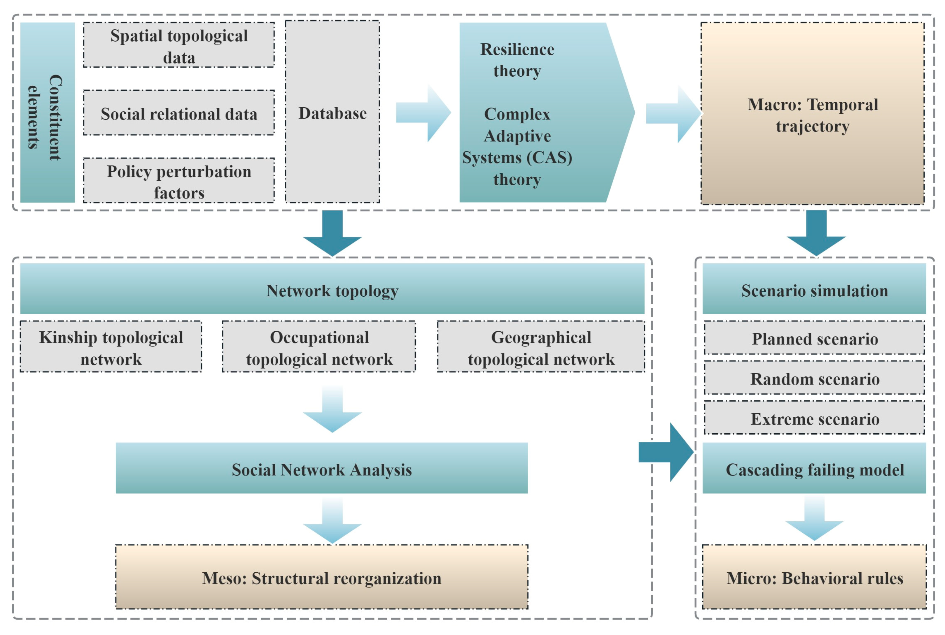
2. Spatial Adaptability Research Framework

To promote the inheritance of intangible cultural heritage, research should integrate the perspective of actors’ behaviors to reflect the adaptive changes in village spatial functions throughout the evolution of diverse social relationships. The cross-scale integration from resilience theory to complex adaptive systems (CAS) theory provides a theoretical framework for studying the spatial adaptability of traditional villages [15]. In the macro-temporal dimension, the “r-stage exploitation, k-stage conservation, Ω-stage release, and α-stage reorganization” model proposed by Holling reveals the time trajectory of system evolution [4]. Its core value lies in constructing the feedback logic in the process of disturbance absorption, structural adjustment, and functional transition [16]. At the mesoscale, Folke’s adaptive cycle model explains the driving logic of spatial reconstruction through the structural transformation mechanism of social networks, including the release of capital stock and the reorganization of innovation elements [17]. At the microlevel, CAS theory reveals the dynamic mechanism driving the reconfiguration of spatial elements through the formal modeling of subject adaptive behavior [18], the spatial transmission mechanism of nonlinear interaction [19], and modular reorganization techniques [20]. Based on complex systems theory, this study defines spatial adaptability as a village system’s ability to dynamically reconfigure spatial elements through social network topology optimization (such as the reorganization of node centrality), thereby maintaining the dynamic adjustment ability of multifunctional balance [21]. This definition integrates cross-scale mechanisms: the macrolevel based on the temporal trajectory of social–spatial system evolution, the mesolevel focusing on the driving logic of social network structural transformations on spatial reconstruction, and the microlevel achieving the dynamic coupling of agent behavior and spatial functions by identifying systems, interaction rules, and modular mechanisms.
The evaluation methods of the spatial adaptability of traditional villages are mainly divided into three categories. The first category is the comprehensive indicator system method [22], which evaluates spatial adaptability through multiple dimensions such as ecology, economy, and society [23]. Although this method can reflect the overall characteristics of village space, it has limitations in depicting the nonlinear relationships between social relationships and village space [24]. The second type incorporates system dynamics models [18]. These methods simulate the feedback effects of social, economic, and environmental factors on spatial adaptability through mathematical models. Their advantage is that they can analyze the adaptation process of space under external shocks. However, they face challenges in accurately modeling the dynamic interactions of kinship, geographical ties, and occupational relationships [25]. The third type is the social network analysis method, which quantitatively analyzes the role of social factors such as gentry governance and ethnic relations in reconstructing spatial patterns by constructing an interactive network between subjects and space [26]. Combined with multiagent methods, this method can simulate temporal evolution trajectories of space, making it useful for depicting nonlinear relationships and dynamic interactions. It is helpful for studying traditional village spatial adaptability evolution.
In summary, as shown in Figure 1, this paper establishes an analytical framework composed of “macrolevel temporal trajectories, mesolevel structural reorganization, and microlevel behavioral rules” to analyze the spatial adaptability evolution mechanism of traditional villages under changing social relationships. At the macrolevel, spatial topology characteristics are extracted from multisource heterogeneous data (such as satellite imagery and field surveys). A social relationship adjacency matrix is constructed through in-depth interviews, and social disturbance nodes (e.g., thresholds for changes in the household registration system) are identified from policy documents. Based on complex network theory, a dynamic topological network is established to interpret its spatiotemporal evolution pathways. At the mesolevel, a three-dimensional network analysis model (kinship, occupational, and geospatial networks) is introduced, which integrates social network analysis to quantify network evolution characteristics and reveal mechanisms of spatial adaptability. At the microlevel, a cascade failure model is employed to simulate the coupling behavior of actors and space under three stress scenarios: planning-driven, random disturbance, and extreme pressure. By quantifying system adaptability, key nodes within the system are identified, which informs the development of an adaptive planning intervention framework.

3. Materials and Methods

3.1. Typicality Analysis of Case Village

Tangjia Village is situated in the center of the Weibei Loess Plateau gully region, covering an area of approximately 3 square kilometers. It is a typical “tableland-type” traditional village, famous for the Tangjia Courtyard built in the Ming Dynasty (Figure 2). In the process of urbanization, with the continuous influx of people from the surrounding “gully-type” villages and the progressive development of tourism at Tangjia Courtyard, the traditional clan relationships within the village have rapidly weakened over the past decade The villagers’ spiritual culture has shifted from a collective identity rooted in kinship to an emphasis on individual development and external connections. Therefore, kinship ties have been rapidly disintegrated, and the endogenous development momentum of the settlement is obviously insufficient. At the same time, the existing spatial layout is difficult to adapt to and carry new geographical and industrial relations, resulting in dilapidated public spaces such as ancestral halls and squares, as well as vacant residential houses. Externally, the social production activities of villagers in recent years are no longer limited to traditional agricultural resources such as land, water sources, and raw materials. Social interactions and services have also gradually exceeded the scope of villages and towns, and they tend to choose housing, education, and healthcare options in counties and cities. This shift has rendered the original village–town system inadequate in meeting residents’ evolving needs, resulting in imbalanced resource allocation and mismatched public services. The fundamental issue lies in the contradiction between the rapidly changing social relationship patterns and the sluggishly evolving settlement space, a challenge universally faced by traditional villages in this region. Therefore, Tangjia Village is selected as the case study for this research.

3.2. Data Source

The research data includes village boundary vector data, satellite images, questionnaires, and interviews, as well as official documents related to the study area. The village boundary data comes from the third national land survey conducted by the Natural Resources and Planning Department. Satellite imagery is obtained from the Geospatial Data Cloud (http://www.gscloud.cn/, accessed on 17 July 2018). For the questionnaire and interview part, participants were selected through random sampling proportional to the village population and cadre ratio. A total of 190 questionnaires were distributed, with 152 returned and 122 deemed valid after quality screening. To ensure data accuracy, university researchers conducted face-to-face interviews during household visits, directly recording responses from either the household head or primary resident. The questionnaire design was based on the findings of preliminary in-depth interviews. It covered aspects such as the kinship networks of household heads or primary permanent residents within the village, work-related contacts, and participation in cultural and recreational activities. On average, each valid questionnaire recorded approximately 5 kinship-related entries and 10 to 15 entries related to work and leisure interactions. To supplement village background information, the research team simultaneously conducted structured interviews with village cadres to obtain basic data on the surveyed administrative villages, including the scope of construction land, population mobility, villagers’ income structure, the development of characteristic industries, and the distribution of regional natural resources. In addition, official documents such as government work reports and rural planning documents were used to further verify and refine the administrative-level data background.

3.3. Data Processing

Based on satellite images, questionnaires, interviews, and government report data, the years 2001, 2011, and 2021 were selected as key research years to organize the spatial data of Tangjia Village (see Table 1 and Figure 3).
Network Node Identification: The social network nodes in Tangjia Village can be divided into three categories. The first category is residential space nodes, which correspond to each household and their respective buildings [27]. The geometric center of these nodes represents the geographic coordinates of the residential spaces, while their attributes reflect the generational relationships among family members. The second category is industrial space nodes. This category includes daily work locations such as households, farmland, commercial areas, factories, historical buildings like Tangjia Courtyard, the village committee, and nearby urban centers like Xunyi County and Xianyang City. The geometric center of industrial space nodes corresponds to the geographical location of their industrial activities. For ease of analysis, urban centers are symbolically proximate to the settlement area in illustrations [28]. The attributes of these nodes reflect the types of industries in different spaces. The third category is recreational space nodes, representing venues for villagers’ daily social activities, including household buildings, agricultural parks, historical buildings, and squares. The geometric center of these nodes indicates the geographic coordinates of recreational spaces, while their attributes describe the types of recreational activities conducted in these spaces.
Network Edge Identification: The social network edges in Tangjia Village can be divided into three categories [29]. The first category is kinship ties, established through connections between residential space nodes. Such ties are defined by a direct family relationship within three generations between two households, with attributes defined as kinship [30]. The second category is occupational ties, formed by linking residential space nodes to industrial space nodes. An occupational tie is identified when a villager holds a formal job at an industrial space node and works there for no less than six months within a year. Relationships meeting these criteria are attributed as occupational ties [31]. The third category is geographical ties, connected through residential and recreational space nodes. Geographical ties are determined under two conditions. For recreational space nodes outside the settlement, if a villager visits the site at least three times within a month or spends over 50% of their time there during official long holidays, a geographical tie can be established [32]. For the recreational space nodes within the settlement, if a household of villagers conducts recreational activities at least three times in a week, a geographical relationship can be established between the nodes. The relationship attributes in both cases are geographical ties.

3.4. Research Methods

3.4.1. Topological Simulation

First, the social relationship data is used to construct a binary adjacency matrix. In this process, the spatial elements, social subjects, social relationships, and spatial connections of Tangjia Village in 2001, 2011, and 2021 are compiled into a network structure consisting of nodes and edges [33,34].
Secondly, a cascade failure model is employed to simulate the structural evolution of the village system under external disturbances. This methodology simulates chain reactions triggered by the failure of spatial functional units (e.g., residential clusters, industrial nodes) through the progressive removal of nodes and their connected edges within the settlement network. Upon node failure, its original functions are redistributed to adjacent nodes based on spatial proximity and functional linkage intensity. If the additional functions received by these neighboring nodes exceed their own capacity, failure will occur, triggering a cascading propagation of failure [34,35,36].
To comprehensively evaluate the system’s response capacity under distinct intervention pathways, this process was implemented across three disturbance scenarios: the “planning scenario” prioritizing planning-oriented guidelines, the “random scenario” simulating stochastic disruptions, and the “extreme adverse scenario” emulating deliberate attacks [37]. Aligned with the objective of mitigating negative outcomes while amplifying positive impacts, the planning scenario follows the Tangjia Village Construction Plan (2021–2035). Nodes were iteratively removed based on actual construction difficulty gradients until a 60% urbanization rate was achieved (terminated upon retaining 40% of nodes). The random scenario emulates the settlement’s adaptability to unpredictable external disturbances (e.g., policy shifts) through completely stochastic deletion of nodes and edges. Conversely, the extreme adverse scenario evaluates the “peak resistance capacity” of spatial structures against external shocks by sequentially removing nodes and edges based on the descending order of betweenness centrality.

3.4.2. Adaptability Evaluation Indicator System

  • Integrity
In order to evaluate the interaction frequency and resource exchange efficiency between social and spatial nodes within the village, network density is selected to analyze the proportion of actual connections in the network [38]. Network density can reflect the closeness and connection strength within the system. The calculation formula for network density is as follows:
D = L g g 1 2 = 2 L g g 1
where g is the total number of village spatial units and social actor nodes in the network, and L is the existing social interactions and spatial connections within the village.
2.
Stability
In complex network theory, cohesive subgroups refer to collections of closely connected social groups. This paper analyzes the K-core decomposition in the village social network and reveals the spatial distribution characteristics and connection patterns between different social groups. Among them, the K-core value captures the system’s structural core strength, with higher-core nodes indicating stronger internal support and greater potential for adaptive transformation [39].
3.
Resilience
Betweenness centrality is used to measure the structural robustness of the network. Since the failure of intermediary nodes can lead to network fragmentation, nodes with high betweenness centrality are crucial for system resilience. In traditional villages, these nodes often serve as key individuals and connectors between different families, areas, or social groups [40]. The calculation formula is as follows:
C b ( v ) = s v t σ s t ( v ) σ s t
where σ s t is the total number of shortest paths from node s to node t, measuring the connectivity between nodes in the network, and σ s t ( v ) is the number of those paths passing through node v. The higher this value, the more significant the intermediary role of node v in the network.
4.
Recoverability
In order to evaluate the efficiency of social information and resource transmission in the network, network efficiency indicators can be used. Network efficiency is used to measure the resilience of village space. High efficiency indicates that the network can quickly recover and reestablish connections after disturbances [41]. The calculation formula is as follows:
E ( G ) = 1 N ( N 1 ) i j N 1 d ( i , j )
where N is the total number of nodes in the network, referring to all spatial units and social actor nodes in the village network, and d ( i , j ) is the shortest path length between nodes i and j.
5.
Connectivity
In order to measure the ability of complex systems to maintain basic social connections or continuous development of the spatial environment under externally caused disturbances, this study uses the relative size of the largest subgraph to evaluate the connectivity of space [42]. Its calculation formula is as follows:
K S = K N L K N
where K N L is the number of nodes in the largest connected subgraph, representing the total count of nodes included in the most extensive connected social–spatial structure within the village system, and KN is the total number of nodes in the graph, encompassing all village spatial units and social actor nodes.

4. Results

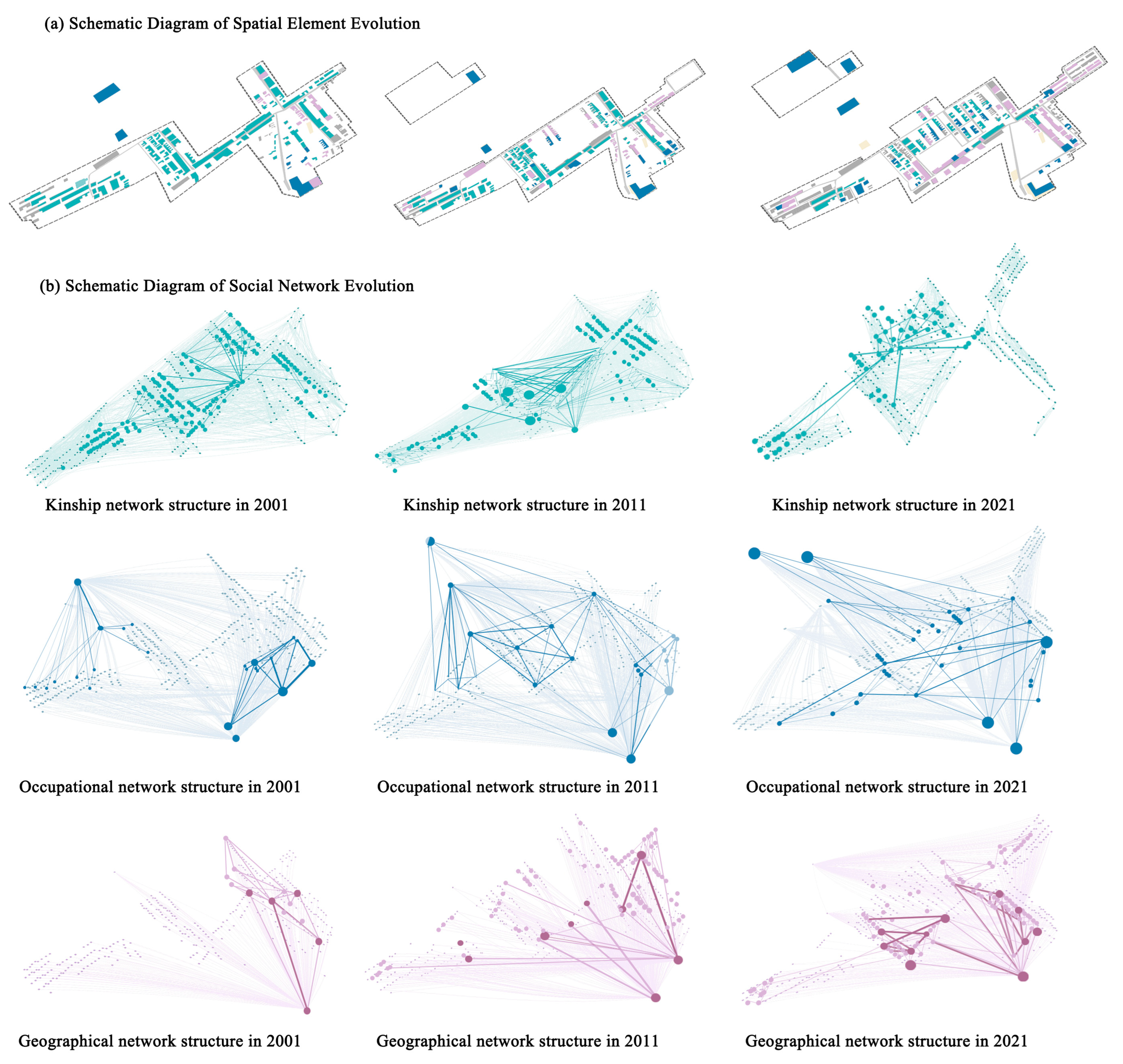
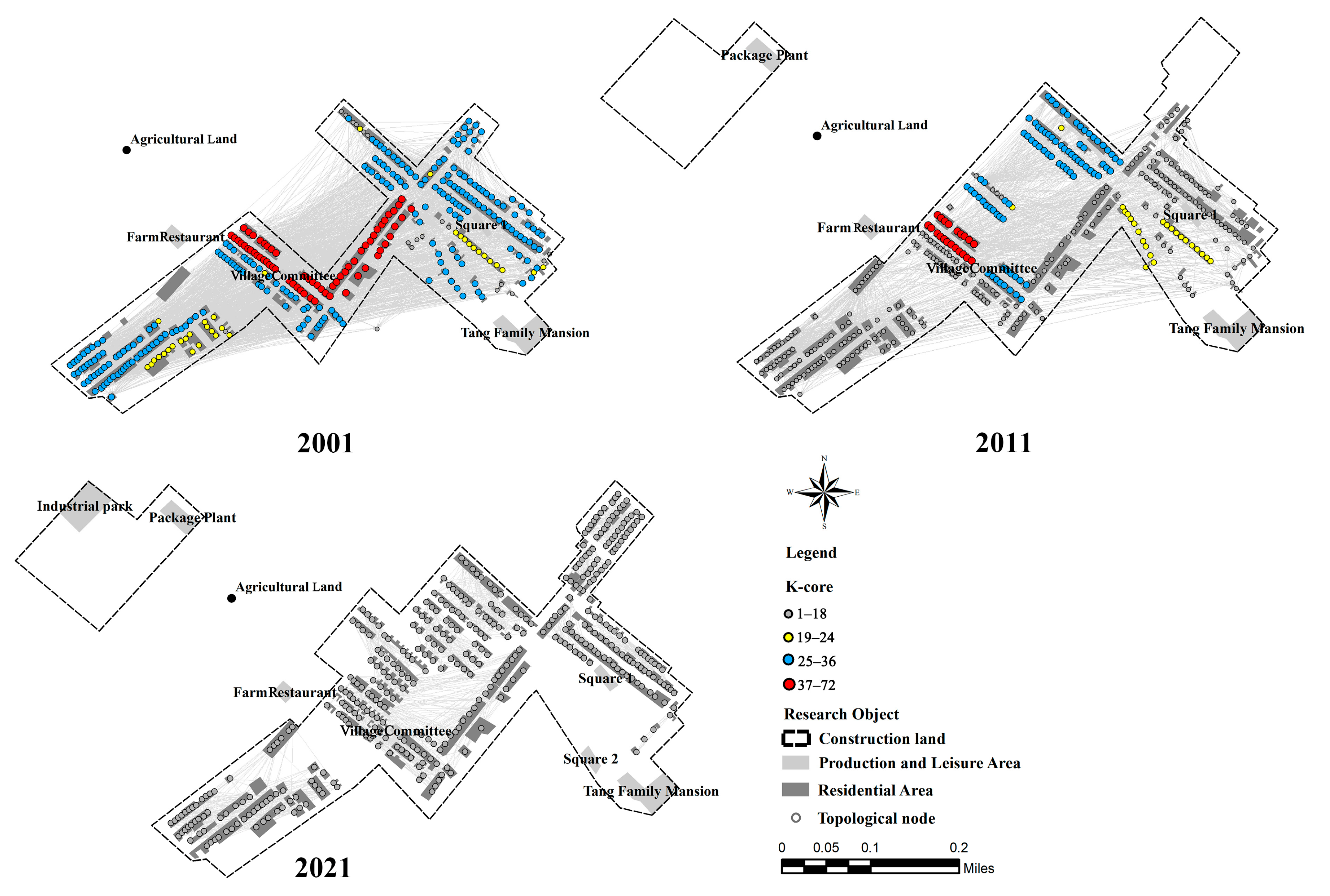
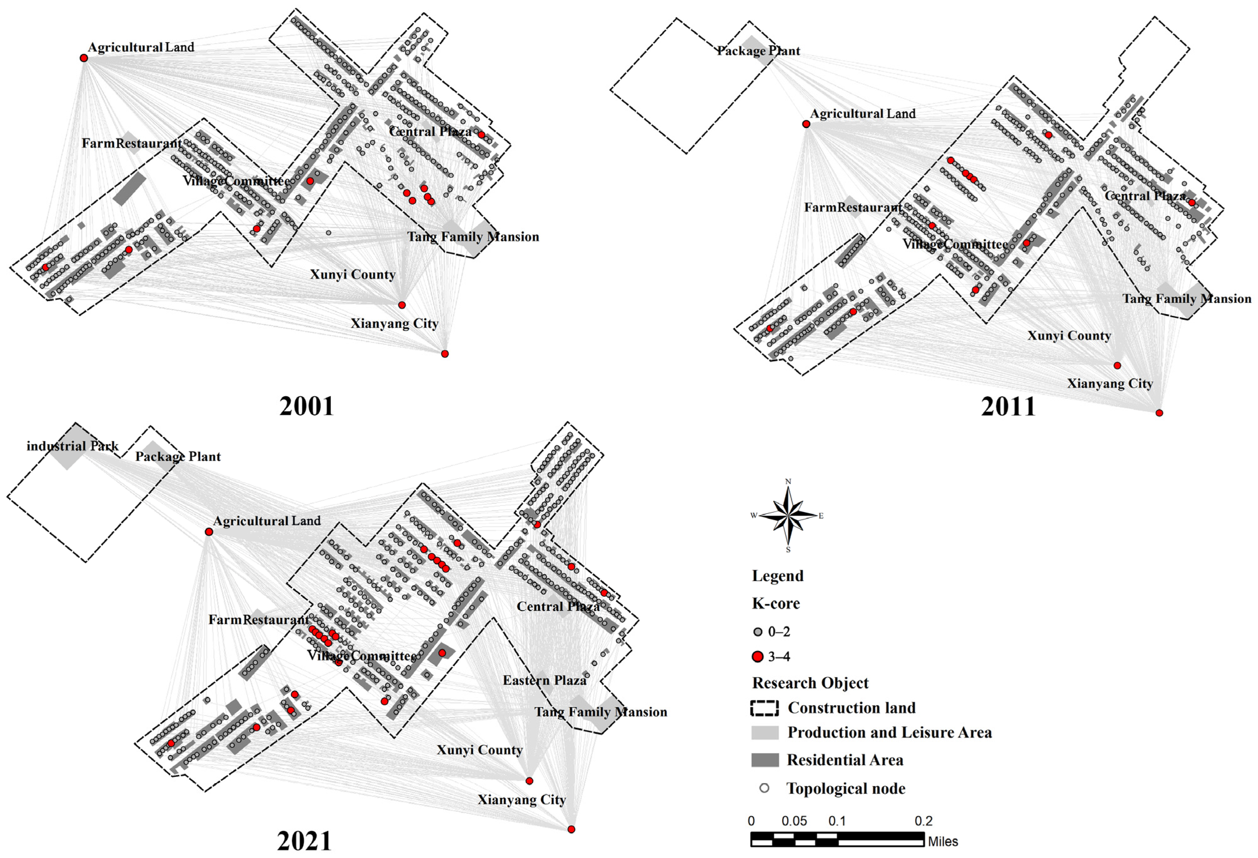
4.1. Spatial Evolution Simulation

The years 2001, 2011, and 2021 were selected as time points for observing the evolution of social relations and village space, and the evolution diagram of the relationship topology network and village spatial structure of Tangjia Village is depicted in Figure 4.
In 2001, 2011, and 2021, the size of the kinship network (i.e., the number of nodes) was 342, 375, and 402, respectively. However, the network density showed a gradually decreasing trend. By 2021, the number of edges was only 33.2% of that in 2001. From the perspective of spatial distribution, in 2001, the nodes were mainly concentrated in the village center, demonstrating high aggregation. By 2011, nodes began spreading toward the west and north, with the network structure becoming more dispersed. By 2021, nodes had been evenly distributed around the village center. However, the original core area had vanished, and node density further decreased. Therefore, the kinship space showed a trend of gradually spreading outward from central aggregation and ultimately becoming scattered.
In terms of occupational networks, the node counts were 348 in 2001, 382 in 2011, and 410 in 2021, with edge counts of 1066, 1165, and 1286, respectively, indicating steady growth in network size and connection density. Spatially, in 2001, occupational nodes were mainly concentrated in the eastern part of the village, with key nodes including farmland, the village committee, Tangjia Courtyard, and Xunyi County and Xianyang City districts. By 2011, occupational nodes had gradually expanded to the village’s center. By 2021, due to the establishment of an industrial park on the west side, the distribution of occupational nodes became more uniform. Consequently, the occupational space displayed a trend of gradual expansion and homogenization.
In 2001, 2011, and 2021, the number of nodes in the geographical networks was 346, 379, and 408, respectively. By 2021, the number of edges was twice that of 2001, showing a significant increase in network scale and connection density. Spatially, in 2001, geographical nodes were primarily concentrated in the northern part of the village, forming a northern-centric aggregation pattern with key nodes such as some household points, a central square, and Tangjia Courtyard. By 2011, geographical nodes had expanded throughout the entire village, achieving an even distribution. However, by 2021, geographical nodes had once again formed clusters in the eastern and central parts of the village. Thus, the geographical space experienced a development trend from regional concentration to comprehensive expansion, and then to multicenter agglomeration.

4.2. Network Evolution Characteristics

As illustrated in Figure 5 and Table 2, the integrity of the kinship network is analyzed by the network density index. In 2001, the network density was at its highest, and then it declined year by year. By 2021, the density of the kinship network was only 18.6% of that 20 years ago. This change reflects that Tangjia Village has gradually evolved from a “Tang” surname village with close blood ties to a multisurname village with relatively loose kinship ties. The stability of the kinship network is assessed through the K-core index. In 2001, 2011, and 2021, the maximum K-core of the kinship network in Tangjia Village decreased from 72 to 40, and then to 8. If the 8-core or above region is regarded as the standard for network stability, the network stability in 2021 had decreased by 88.9% compared with 2001. Simultaneously, the number of core subgroups decreased from 12 in 2001 to 3 in 2021, indicating the reduction in both global and local network stability. The resilience of the kinship network is evaluated using the betweenness centrality indicator. With 0.01 as the threshold, the number of key members in the kinship network was 4, 32, and 0 in 2001, 2011, and 2021, respectively. The frequent interactions in the first decade increased the number of key nodes, while the rapid urbanization in the second decade led to a significant decrease in bridge nodes. The gradual contraction of kinship networks directly reflected the erosion of the kinship-dominated centripetal structure during urbanization, while simultaneously validating the progressive dissolution of the small-scale peasant economy.
As shown in Figure 6 and Table 2, the integrity of the occupational network is analyzed by the change in network density. From 2001 to 2021, the density of the industry network increased by only 15.7%. Although several new occupational nodes were added in 2021, the overall connectivity did not significantly strengthen. While villagers gained new job opportunities, they lost traditional agricultural ties, and the proportion of part-time villagers remained relatively low. The stability of the occupational network is assessed by the K-core index. Although the maximum K-core value of the industry network structure of Tangjia Village was 4 in 2001, 2011, and 2021, the proportion of stable network areas increased by 65.2% in 2021 compared to 2001. Most of the newly added stable network areas are located in the new village area in the central part, and their stable and diverse employment environment mainly relies on the support of the foreign population. The resilience of the occupational network is analyzed by the betweenness centrality index, with 0.001 as the threshold. In 2001, 2011, and 2021, the number of key members in the occupational relationship network was 6, 6, and 71, respectively. Over the past decade, cultural tourism development at Tangjia Courtyard has driven villagers to participate in the cultural and tourism industries, significantly increasing the number of key nodes. The robust expansion of occupational connections marks a pivotal societal shift. Occupational ties now supersede kinship as the primary driver of social restructuring, reflecting the livelihood imperatives necessitating the transition from subsistence agriculture to diversified livelihood portfolios.
As shown in Figure 7 and Table 2, the integrity of the geonetwork is analyzed by the change in network density. Compared to 2001, the geographical density in Tangjia Village increased notably from 0.0026 to 0.0075 in 2021, an increase of 188.46%. This is due to the continuous construction of internal communication venues in the village and the increasing richness of villagers’ cultural and recreational activities. The stability of the geographical network is evaluated using the K-core index. The maximum K-core value of the geographical network structure was 4, 4, and 8 for the years 2001, 2011, and 2021, respectively. If the area above 4 cores is regarded as a stable network area, the stability of the geographical network in 2021 has doubled compared to 2001. The number of core subgroups increased significantly over the past decade, indicating that the geographical relationship network has become increasingly stable and the rural cultural construction has achieved remarkable results. The resilience of the geographical network is analyzed using betweenness centrality with a threshold of 0.001. In 2001, 2011, and 2021, the number of key members in the geographical relationship network was 17, 116, and 15, respectively. The development trend of the geographical network reflects changes in the village’s demographic structure and spatial utilization patterns, specifically manifested in Tangjiacun’s transition from a single-surname community to one characterized by surname diversification, as well as the differentiation of cultural and recreational space functions. Fundamentally, this spatial reorganization corroborates the broader societal trend of accelerated integration between urban and rural elements.

4.3. Spatial Adaptability Prediction

As shown in Figure 8a, under the planning scenario, the kinship network exhibits high connectivity and resilience. In the orderly attack stage, both the network efficiency and the largest subgraph proportion remain stable, indicating that the core clan nodes play a key role in maintaining the overall connectivity and social support of the network. When the node attack rate approaches 60% (the rate at which urbanization is completed), although network efficiency and the largest subgraph proportion decrease to 72.43% and 88.13% of their initial values, respectively, they still maintain adequate capacity for resource transfer and social connection. In the random scenario, network efficiency and the largest subgraph proportion decline only slightly to 96.55% and 94.45% of their initial values after a random loss of 30% of nodes, reflecting strong kinship ties within Tangjia Village. However, under extreme adverse conditions, once the core clan nodes of the village are lost first, the buffering and recovery capacity of the kinship network will be greatly reduced. Such nodes account for about 21% of the total, and their loss will lead to a lack of sufficient resilience in the face of adverse changes. Therefore, there are about 80 key nodes in the kinship network, mainly located in the clan settlement area in the south of the village. These nodes serve as bridges between distinct kinship groups, facilitating the transmission of shared values, rituals, and collective memory. Consequently, they function not only as spatial and relational hubs but also as key anchors of villagers’ emotional ties and sense of cultural belonging.
As shown in Figure 8b, under the planning scenario, the efficiency and the largest subgraph proportion of the occupational network are stable in the early stage, indicating that retaining key industry nodes effectively supports resource transfer and network connectivity. Nevertheless, when the node removal rate approaches the “urbanization completion” threshold, the network efficiency and the largest subgraph proportion notably decrease to 74.84% and 67.63% of their initial values. This suggests that the occupational network has high connectivity and recovery capabilities while retaining core nodes. In contrast, under random conditions, network efficiency and the largest subgraph proportion rapidly drop to 49.82% and 58.53% after a 30% node loss, highlighting the destructive impact of unplanned disturbances on the occupational network. Under extreme adverse conditions, the core industrial nodes of the village are lost first. Due to their limited number, their loss would render the village’s industries extremely fragile. Therefore, the key nodes in the occupational network include the following five: Tangjia Courtyard, farm stays, the industrial park, the packaging plant, and the village committee. These nodes perform essential functions of resource transfer and social connectivity in the network, supporting the stability of the village’s economic activities and employment network.
As depicted in Figure 8c, under the planning scenario, the geographical network’s efficiency and largest subgraph proportion remain stable. When the node removal rate nears the “urbanization completion” ratio, these indicators stand at 49.65% and 66.82% of their initial values, respectively, showing good recovery capacity and connectivity when core nodes are preserved. However, under random conditions, the geographical network’s efficiency and largest subgraph proportion significantly drop to 21.54% and 46.40% after a 30% node loss. This indicates vulnerability within the geographical network and a strong dependence on core nodes. Under extreme adverse conditions, the loss of a small amount of entertainment space may lead to a significant decline in social interactions and cultural practices. Therefore, the key nodes affecting the geographical network include the following five: Tangjia Courtyard, farm stays, the central square, the eastern square, and farmland. These nodes serve pivotal roles in resource transfer and social connection in the network, supporting the spatial structure of villagers’ daily interactions.

5. Discussion

5.1. Village System Adaptation Evolution Path Identification

According to the adaptive cycle theory, the spatial adaptability evolution process of Tangjia Village can be divided into three stages: absorption, adaptation, and reorganization.
During the absorption phase (before 2001), the village exhibited a dense kinship network (density of 0.82) with a highly cohesive structure (K-core = 72), forming a “high potential–low connectivity” stable layout. This aligns with the “exploitation (r) and conservation (k)” phases in the adaptive cycle model. As the cultural core, the old street supports the compact layout of traditional residential space, aligning spatial functions closely with agricultural livelihoods.
As the village entered the adaptation phase (2001–2011), societal changes such as household registration (hukou) reforms and improvements in tourism infrastructure triggered rural migration and livelihood transitions, leading to a 62% decrease in kinship network density. The system transitioned into a critical “release (Ω)–reorganization (α)” state. The occupational network expanded industrial spaces by occupying structural holes (adding 65.2% more stable areas), while traditional residential spaces were reconfigured and repurposed.
In the reorganization phase (after 2011), the density and K-core metrics of the geographical network increased significantly, marking the system entering the “reorganization (α)” stage. The interaction among villagers is increasingly linked to economic interests, creating a dual-cluster structure of recreational spaces in the north and south. It shows a new “multicenter–weak connection” topological feature. Concurrently, traditional settlement spaces gradually disappeared, with industrial spaces evolving from point-like distributions to chain-like clusters.

5.2. Spatial Adaptation Evolution Mechanism Under Social Reconstruction

According to the comparison of the K-core index of the kinship network and the settlement space elements, the evolution of the traditional spatial pattern of Tangjia Village can be observed (see Figure 5). Before 2001, the village developed around the old street, relying on close blood relations to form a “single-center structure” with secondary building clusters distributed at the periphery. Between 2001 and 2011, with the deaths of the elderly in the traditional core area and the outflow of population, the core nodes gradually weakened, and the kinship ties began to shift to the new residential areas in the west and north. At the same time, the kinship ties originally located in the south of the village also weakened. In terms of spatial layout, this change led to vacant or even abandoned homesteads, demonstrating characteristics of “central collapse and peripheral shift”. After 2011, the influx of outsiders further diluted the “Tang family” blood ties within the village. By then, Tangjia Village had almost no significant kinship ties, with core groups and nodes in traditional settlement spaces nearly disappearing. These changes indicate that the disintegration of the kinship network has accelerated the decline of traditional residential spaces.
According to the comparison between the K-core index of the occupational network and the elements of the settlement space, the industrial development trajectory of Tangjia Village can be shown (see Figure 6). Before 2001, employment in the village lacked systematic organization, with villagers primarily engaged in agricultural work, and only a few involved in basic services at Tangjia Courtyard. The industrial space was characterized by a scattered distribution. Over the next decade, with an increasing number of external investors, the occupational network expanded continuously. To improve service quality and the employment environment, the government undertook protective construction at Tangjia Courtyard and promoted the conversion of central village residences to mixed-use commercial and residential formats, enabling functional replacement. Additionally, a packaging plant was constructed in the northwest part of the village, creating a dual-core structure of “Tangjia Courtyard” and “workshops” within the industrial space. After 2011, the employment situation in Tangjia Village further improved, the number of jobs provided became increasingly abundant, and the industry network expanded to the northwest region. The government planned to build a packaging industrial park and finally formed an integrated industrial chain space cluster of “production, processing, service”. These changes illustrate that the expansion of the occupational network effectively facilitated the development and enhancement of industrial spaces.
According to the comparison of geographical K-core indicators with settlement spatial elements (see Figure 7), significant changes have occurred in the geographical relationships and recreational spaces of Tangjia Village. Before 2001, the geographical relationship between villagers was mainly established through kinship and clan identity and was relatively closed overall. The geographical connection with the outside world was mainly through the Tangjia Courtyard, the central square, and sporadic farm stays to the north. Thus, recreational spaces were scattered, small in size, and concentrated predominantly on the eastern stretch of the old street, consisting mainly of ancestral temples and small squares. Between 2001 and 2011, the spiritual culture of the village gradually opened up, and farmers’ families began to become new geographical nodes. At the same time, the development of Tangjia Courtyard facilitated the establishment of an eastern square, which along with mixed-use commercial and residential buildings in the village center, supported a significant amount of external geographical connections. During this phase, geographical relationships transitioned from “kinship dependence” to “interest sharing”, with a notable increase in the number and dispersion of recreational spaces. Since 2011, the government has redeveloped idle residences around Tangjia Courtyard and enhanced rural tourism service facilities, significantly improving the area and quality of local public spaces and forming a more centralized new type of geographical relationship. At this stage, the recreational spaces in Tangjia Village evolved into distinct northern and southern clusters. These changes indicate that the differentiation of the geographical network has driven the reconstruction of recreational space.
In summary, the evolution of Tangjia Village has gone through three major development stages: the spatial stability period dominated by kinship before 2001, the spatial renewal period driven by industry from 2001 to 2011, and the spatial reconstruction period under geographical differentiation after 2011. Prior to 2001, villagers organized agricultural production, public rituals, and residential layouts through blood-based kinship networks, forming a high-density, monocentric settlement pattern. During this phase, geographical ties (e.g., neighborhood interactions) and occupational ties operated as secondary support systems subordinate to the kinship structure. From 2001 to 2011, the shift to a nonagrarian economy catalyzed occupational ties (e.g., employment and collaboration), which emerged as the dominant force reshaping spatial organization. The original kinship networks weakened under intensified population mobility, enabling industrial spaces to segregate from residential zones and repurpose recreational areas for economic functions. Geographical ties, such as neighborhood cooperation, played a supporting role in facilitating the spatial integration of occupational expansion at this stage. From 2011 onward, tourism and e-commerce spurred commercially oriented geographical ties, rooted in economic alliances between local villagers, external capitalists, and operators. These market-driven relationships propelled the functional synthesis of recreational, industrial, and residential spaces. Traditional kinship relations had further dissolved, while occupational ties had merged into commercial geographical networks, collectively forming a multifunctional and multiscaled spatial system. This study further supports the significant impact of social relationships on spatial adaptability. Existing research has demonstrated that heritage conservation actions can enhance the resilience of heritage communities [43], while improvements in community trust and connectivity also contribute to strengthening community resilience [44].

5.3. Adaptive Planning Response Under Subjective Behavior Simulation

This study revealed that Tangjia Village is currently in the reorganization phase (α) of the adaptive cycle. To achieve a positive transition toward the exploitation phase (r), it is necessary to implement a transmission mechanism focused on “potential, connectivity, and resilience” [45]. This transition is driven by the dynamic interaction between social resource reorganization and spatial structure reconstruction. Therefore, in the conservation planning of traditional villages, a regulatory approach that integrates kinship node protection, occupational cluster reorganization, and geographical path renewal can be adopted to enhance spatial adaptability.
Firstly, the maintenance of kinship nodes serves as the anchor of the system’s cultural foundation. It is recommended to designate 80 clan nodes in the southern area (ancestral halls/courtyards) as a “Cultural Heritage Protection Zone”. Commercial redevelopment should be prohibited, while traditional functions (such as genealogy preservation and clan activities) should be reinforced. This will ensure that the efficiency of the kinship network remains above 70%, thereby safeguarding cultural heritage as a key storage unit of potential during the reorganization phase and preventing the risk of degradation caused by resource loss. Secondly, the reorganization of occupational clusters can mitigate the risk of single-point failure. It is recommended to add three to five secondary hub nodes (such as logistics centers and e-commerce bases) between the northwest packaging industrial park and the central mixed-use areas. This will fill structural gaps in the occupational network, reduce dependence on the Tang Family Courtyard, and create a multicore, redundant topology. Such a configuration shortens resource allocation paths and drives the industrial pattern from “isolated points” to “coordinated chains”. Finally, geo-spatial pathway renewal is a solution to spatial differentiation bottlenecks. By introducing transitional public spaces (e.g., community squares, cultural centers) between the northern and southern clusters, spatial connectivity will be enhanced. Simultaneously, five key cultural and recreational nodes (such as Tangjia Courtyard and Central Square) can be upgraded, incorporating traditional cultural activities (e.g., intangible cultural heritage markets, festive performances) to stimulate social capital density and reinforce system resilience [46].

6. Conclusions and Prospects

Based on multisource data including satellite imagery, interviews, and policy documents, this study employed social network analysis and an improved cascade failure model to construct a framework for analyzing spatial dynamic adaptability. The research confirms the adaptive evolution pathway of the village from “kinship maintenance” (absorption phase) to “occupational expansion” (adaptation phase), and then to “geographic differentiation” (reorganization phase). During the absorption phase (before 2001), a “single-center” spatial steadiness dominated by kinship networks was observed. In the adaptation phase (2001–2011), occupational networks drove the differentiation of spatial functions. In the reorganization phase (after 2011), geographic networks facilitated the integration of spatial functions. This process highlights the cyclic discontinuity in the development of traditional villages. By identifying different evolutionary stages, measures such as attracting original residents back to the village for entrepreneurship and increasing new business functions can promote positive social and spatial interaction and development.
Furthermore, this study reveals that the disintegration of kinship networks leads to the decline of traditional residential spaces, while the expansion of occupational networks drives the enhancement of industrial spaces. Meanwhile, the differentiation of geographic networks facilitates the reconstruction of cultural and entertainment spaces. Therefore, the optimization of social relationships can enhance the spatial adaptability of traditional villages. Moreover, in future scenario simulations, kinship networks exhibit relatively high adaptability, mainly supported by 80 clan nodes concentrated in the southern settlement area of the village. In contrast, the adaptability of occupational and geographic networks is relatively weaker, relying on a few key nodes such as Tangjia Courtyard, farm stays, industrial parks, and packaging factories. Based on these findings, adaptive planning strategies are proposed.
This study innovatively constructs a dynamic coupling model between social networks and spatial topology, overcoming the limitations of traditional settlement studies that rely on static attribute analysis. By incorporating perspectives on individual behavior, it addresses the lack of microscale research in the region [47]. Additionally, by integrating multisource data (such as satellite imagery, in-depth interviews, and policy documents), a spatiotemporal analysis framework is established. This framework reveals the nonlinear transmission mechanism between social network fission and spatial function reorganization. Furthermore, a three-stage evolutionary pattern is confirmed: the disintegration of kinship networks leads to the decline of residential spaces, the expansion of occupational networks drives the transformation of production spaces, and the differentiation of geographic networks facilitates the reconstruction of cultural and entertainment spaces. Crucially, this study considers potential future development scenarios for villages based on the current social relationships and spatial functions. It identifies key kinship hub nodes crucial for the preservation of intangible cultural heritage and proposes a collaborative governance framework of “kinship anchoring, occupational cluster regeneration, and geographical path renewal”. Compared to traditional conservation planning, this approach offers quantifiable decision paths for the revitalization and continuous inheritance of intangible cultural heritage in traditional villages.
This study examines the impact mechanisms of major social relationships on the spatial adaptability of traditional villages in the gully region of the Weibei Loess Plateau. However, it only utilizes a 20-year observation period and a single-case dimension. It did not fully explore the delayed effects of policy interventions in the context of rural revitalization, such as industrial development cycles which typically last over five years, nor the differentiation patterns among regional village types. Future research should deepen in two dimensions. First, the observation period should be extended to over 30 years. Thus, the impacts of policy interventions, capital flows, and technological reforms on society and space can be quantitatively analyzed. Second, an analytical framework should be developed that includes all types of villages, such as the less common gully-type villages. Through this framework, the mechanisms of spatial adaptability evolution in different traditional village types can be explored, and the evolution trajectories of village systems under various rural revitalization pathways can be predicted.

Author Contributions

Conceptualization, Q.H. (Qin He) and Q.H. (Quanhua Hou); methodology, Q.H. (Qin He); software, Q.H. (Qin He); validation, J.Z., R.D. and Q.H. (Qin He); formal analysis, Q.H. (Qin He); investigation, G.Z.; resources, G.Z.; data curation, X.Z.; writing—original draft preparation, Q.H. (Qin He); writing—review and editing, Q.H. (Qin He); visualization, X.Z.; supervision, Q.H. (Qin He); project administration, Q.H. (Quanhua Hou); funding acquisition, Q.H. (Quanhua Hou) and J.Z. All authors have read and agreed to the published version of the manuscript.

Funding

This research was financially supported by the National Natural Science Foundation of China (Grants Nos. 52408051 and 52178030), the Natural Science Basic Research Program of Shaanxi Province (Grant No. 2024JC-YBQN-0541), and the National Key Research and Development Program of China (Grant No. 2022YFC3802803).

Data Availability Statement

To protect the privacy of villagers, the data will not be made public.

Conflicts of Interest

The authors declare no conflicts of interest.

References

  1. Boussaa, D. The Past as a Catalyst for Cultural Sustainability in Historic Cities; the Case of Doha, Qatar. Int. J. Herit. Stud. 2021, 27, 470–486. [Google Scholar] [CrossRef]
  2. Halamska, M.; Stanny, M. Temporal and Spatial Diversification of Rural Social Structure: The Case of Poland. Sociol. Rural. 2021, 61, 578–601. [Google Scholar] [CrossRef]
  3. Ye, W.; Wang, Y.; Wu, K.; Yang, X.; Yang, Q.; Liu, Q. Exploring the rural transformation of the Loess Plateau from a perspective of community resilience: A case study from the Jiaxian County, northwestern China. Appl. Geogr. 2023, 154, 102919. [Google Scholar] [CrossRef]
  4. Akhtaruzzaman, A.; Khanam, Y.; Rahman, M.S.; Hossen Saikat, S.; Islam, M.T. Resilience of Space: Application of Text Driven Emotion in Urban Planning. Int. J. Innov. Sci. Res. Technol. IJISRT 2024, 1120–1155. [Google Scholar] [CrossRef]
  5. Hongyan, L.; Chongfang, J.; Tao, Z. Analysis on the Traditional Villages Development Methods in Gully Areas of Weibei Loess Plateau: Reflections Based on Fieldwork in Villages of Changwu, Shanxi Province. Huazhong Archit. 2014, 32, 107–112. [Google Scholar]
  6. Qingqing, Y.; Xinjun, Y.; Yanhui, G. Change in Vulnerability of Rural Human Settlement in the Semi-Arid Area of the Loess Plateau Since 1980: A Case Study of Jiaxian County, Shaanxi Province. Available online: https://www.progressingeography.com/CN/10.18306/dlkxjz.2019.05.012 (accessed on 16 November 2024).
  7. Wang, F.; Xu, H.; He, P.; Xue, P.; Gao, X. Adaptive Changes in Traditional Settlements in the Loess Plateau of the Yellow River Basin over 500 Years. River 2023, 2, 186–196. [Google Scholar] [CrossRef]
  8. Miaomiao, L.; Zhendong, L.; Ya, G. Spatial Governance of Rural Watershed in Loess Gully Region under the Background of High-Quality Development: Target, Dilemma and Realization Path. Mod. Urban Res. 2023, 12, 9–16. [Google Scholar]
  9. Zhang, T.; Hu, Q.; Fukuda, H.; Zhou, D. The Evaluation Method of Gully Village’s Ecological Sustainable Development in the Gully Regions of Loess Plateau. J. Build. Constr. Plan. Res. 2016, 4, 1. [Google Scholar] [CrossRef]
  10. Zhanhui, F.U.; Yahan, Y.; Jiajun, Q.; Xiaoyong, Z.H.U.; Xiaojun, J. Rural Hollowing out in the Yellow River Basin and the Development Path of Rural Revitalization. Prog. Geogr. 2024, 43, 1049–1059. [Google Scholar] [CrossRef]
  11. Chen, X.; Xie, W.; Li, H. The Spatial Evolution Process, Characteristics and Driving Factors of Traditional Villages from the Perspective of the Cultural Ecosystem: A Case Study of Chengkan Village. Habitat Int. 2020, 104, 102250. [Google Scholar] [CrossRef]
  12. Kong, X.; Liu, D.; Tian, Y.; Liu, Y. Multi-Objective Spatial Reconstruction of Rural Settlements Considering Intervillage Social Connections. J. Rural Stud. 2021, 84, 254–264. [Google Scholar] [CrossRef]
  13. Yin, J.; Wang, D.; Li, H. Spatial Optimization of Rural Settlements in Ecologically Fragile Regions: Insights from a Social-Ecological System. Habitat Int. 2023, 138, 102854. [Google Scholar] [CrossRef]
  14. Tong, D.; Sun, Y.; Tang, J.; Luo, Z.; Lu, J.; Liu, X. Modeling the Interaction of Internal and External Systems of Rural Settlements: The Case of Guangdong, China. Land Use Policy 2023, 132, 106830. [Google Scholar] [CrossRef]
  15. Long, X.; Yang, P.; Su, Q. On the Effective Organization of Rural Settlements Spatial Structure under the Transformation and Development of Mountainous Areas in Western China: Evaluation Measurement Based on Complex Adaptability Theory. Environ. Sci. Pollut. Res. 2023, 30, 89945–89963. [Google Scholar] [CrossRef]
  16. Walker, B.; Holling, C.S.; Carpenter, S.; Kinzig, A. Resilience, Adaptability and Transformability in Social–Ecological Systems. Ecol. Soc. 2004, 9, 5. [Google Scholar] [CrossRef]
  17. Folke, C.; Gunderson, L. Resilience and Global Sustainability. Ecol. Soc. 2010, 15, 43. [Google Scholar] [CrossRef]
  18. Batty, M. The-New-Science-of-Cities; MIT Press: Cambridge, MA, USA, 2013. [Google Scholar]
  19. Lyu, W.; Zhao, L. A Spatial Connection Aware Complex Network Model for Real-World Social Networks. In Proceedings of the 2023 11th International Conference on Information Technology: IoT and Smart City, Kyoto, Japan, 14–17 December 2023; Association for Computing Machinery: New York, NY, USA, 2024; pp. 155–160. [Google Scholar]
  20. Kenley, E.C.; Cho, Y.-R. Entropy-Based Graph Clustering: Application to Biological and Social Networks. In Proceedings of the 2011 IEEE 11th International Conference on Data Mining, Vancouver, BC, Canada, 11 December 2011; pp. 1116–1121. [Google Scholar]
  21. Wang, G.; Liu, S. Adaptability Evaluation of Historic Buildings as an Approach to Propose Adaptive Reuse Strategies Based on Complex Adaptive System Theory. J. Cult. Herit. 2021, 52, 134–145. [Google Scholar] [CrossRef]
  22. Zhao, X.; Xiang, H.; Zhao, F. Measurement and Spatial Differentiation of Farmers’ Livelihood Resilience Under the COVID-19 Epidemic Outbreak in Rural China. Soc. Indic. Res. 2023, 166, 239–267. [Google Scholar] [CrossRef]
  23. Mu, X.; Fang, C.; Yang, Z. Spatio-Temporal Evolution and Dynamic Simulation of the Urban Resilience of Beijing-Tianjin-Hebei Urban Agglomeration. J. Geogr. Sci. 2022, 32, 1766–1790. [Google Scholar] [CrossRef]
  24. Holimalala, R.; Julien, S.; Thierry, R.; Aina, A.; Rija, R.; Pierre, L.; Mahefasoa, R. The Role of Social Links on Community Resilience and Development: The Case of Ambaro-Bekibo, Vatovavy Fitovinany Administrative Region—Madagascar. Int. J. Appl. Sci. Eng. Rev. 2021, 2, 124–150. [Google Scholar] [CrossRef]
  25. Yu, H.; Du, S.; Zhang, J.; Chen, J. Spatial Evolution and Multi-Scenario Simulation of Rural “Production–Ecological–Living” Space: A Case Study for Beijing, China. Sustainability 2023, 15, 1844. [Google Scholar] [CrossRef]
  26. Borgatti, S.P.; Mehra, A.; Brass, D.J.; Labianca, G. Network Analysis in the Social Sciences. Science 2009, 323, 892–895. [Google Scholar] [CrossRef]
  27. Gamsu, S.; Donnelly, M. Social Network Analysis Methods and the Geography of Education: Regional Divides and Elite Circuits in the School to University Transition in the UK. Tijdschr. Voor Econ. Sociale Geografie 2021, 112, 370–386. [Google Scholar] [CrossRef]
  28. Anderson, T.; Dragićević, S. Complex Spatial Networks: Theory and Geospatial Applications. Geogr. Compass 2020, 14, e12502. [Google Scholar] [CrossRef]
  29. Onnela, J.-P.; Arbesman, S.; González, M.C.; Barabási, A.-L.; Christakis, N.A. Geographic Constraints on Social Network Groups. PLoS ONE 2011, 6, e16939. [Google Scholar] [CrossRef]
  30. Pilisuk, M.; Froland, C. Kinship, Social Networks, Social Support and Health. Soc. Sci. Med. Part B Med. Anthropol. 1978, 12, 273–280. [Google Scholar] [CrossRef]
  31. Alexander, R. Spatialising Careership: Towards a Spatio-Relational Model of Career Development. Br. J. Sociol. Educ. 2023, 44, 291–311. [Google Scholar] [CrossRef]
  32. Morone, P.; Sisto, R.; Taylor, R. Knowledge Diffusion and Geographical Proximity: A Multi-Relational Networks Approach. Open Agric. 2019, 4, 129–138. [Google Scholar] [CrossRef]
  33. Çolak, S.; Schneider, C.M.; Wang, P.; González, M.C. On the Role of Spatial Dynamics and Topology on Network Flows. New J. Phys. 2013, 15, 113037. [Google Scholar] [CrossRef]
  34. Miao, C.; Wang, J.; Zhuang, S.; An, C. A Coordinated View of Cyberspace. arXiv 2019, arXiv:1910.09787. [Google Scholar]
  35. Xia, Y.; Fan, J.; Hill, D. Cascading Failure in Watts–Strogatz Small-World Networks. Phys. A Stat. Mech. Its Appl. 2010, 389, 1281–1285. [Google Scholar] [CrossRef]
  36. Fang, X. Modeling and Analysis of Cascading Failure in Directed Complex Networks. Saf. Sci. 2014, 65, 1–9. [Google Scholar] [CrossRef]
  37. Zhou, J.; Jiang, Y.; Niu, S.; Li, L.; Li, W.; Zhang, Y.; Liu, D. Spatial Optimization of Rural Settlements in a Small Watershed Based on Social Network Analysis. Netw. Spat. Econ. 2023, 23, 799–823. [Google Scholar] [CrossRef]
  38. Wu, C.; Yang, M.; Zhang, H.; Yu, Y. Spatial Structure and Evolution of Territorial Function of Rural Areas at Cultural Heritage Sites from the Perspective of Social Space. Land 2023, 12, 1067. [Google Scholar] [CrossRef]
  39. Brunetta, G.; Ceravolo, R.; Barbieri, C.A.; Borghini, A.; De Carlo, F.; Mela, A.; Beltramo, S.; Longhi, A.; De Lucia, G.; Ferraris, S.; et al. Territorial Resilience: Toward a Proactive Meaning for Spatial Planning. Sustainability 2019, 11, 2286. [Google Scholar] [CrossRef]
  40. Scazzieri, R. Decomposability and Relative Invariance: The Structural Approach to Network Complexity and Resilience. Netw. Spat. Econ. 2022, 22, 635–657. [Google Scholar] [CrossRef]
  41. Liu, R.; Zhang, L.; Tang, Y.; Jiang, Y. Understanding and Evaluating the Resilience of Rural Human Settlements with a Social-Ecological System Framework: The Case of Chongqing Municipality, China. Land Use Policy 2024, 136, 106966. [Google Scholar] [CrossRef]
  42. Zhang, Y.; Yang, Y.; Wei, S.; Ma, Z.; Tian, M.; Sun, M.; Nie, J. Research on Spatial Structure and Resilience of Complex Urban Network: A Case Study of Jing-Jin-Ji Urban Agglomeration. Front. Environ. Sci. 2022, 10, 999124. [Google Scholar] [CrossRef]
  43. Fabbricatti, K.; Boissenin, L.; Citoni, M. Heritage Community Resilience: Towards New Approaches for Urban Resilience and Sustainability. City Territ. Archit. 2020, 7, 17. [Google Scholar] [CrossRef]
  44. Liu, Y.; Cao, L.; Yang, D.; Anderson, B.C. How Social Capital Influences Community Resilience Management Development. Environ. Sci. Policy 2022, 136, 642–651. [Google Scholar] [CrossRef]
  45. Zhang, L.; Huang, Q.; He, C.; Yue, H.; Zhao, Q. Assessing the Dynamics of Sustainability for Social-Ecological Systems Based on the Adaptive Cycle Framework: A Case Study in the Beijing-Tianjin-Hebei Urban Agglomeration. Sustain. Cities Soc. 2021, 70, 102899. [Google Scholar] [CrossRef]
  46. Qu, M.; Cheer, J.M. Community Art Festivals and Sustainable Rural Revitalisation. J. Sustain. Tour. 2021, 29, 1756–1775. [Google Scholar] [CrossRef]
  47. Li, B.; Wang, J.; Jin, Y. Spatial Distribution Characteristics of Traditional Villages and Influence Factors Thereof in Hilly and Gully Areas of Northern Shaanxi. Sustainability 2022, 14, 15327. [Google Scholar] [CrossRef]
Figure 1. Spatial Adaptability Analysis Framework.
Land 14 01290 g001
Figure 2. Location Map of the Study Area.
Land 14 01290 g002
Figure 3. Composition of Social Networks in Tangjia Village.
Land 14 01290 g003
Figure 4. Schematic Diagram of Social Network and Spatial Element Evolution: (a) Schematic Diagram of Spatial Element Evolution; (b) Schematic Diagram of Social Network Evolution.
Land 14 01290 g004
Figure 5. Changes in Kinship Network K-core Indicators.
Land 14 01290 g005
Figure 6. Changes in Occupational Social Network K-core Indicators.
Land 14 01290 g006
Figure 7. Changes in Geographical Social Network K-core Indicators.
Land 14 01290 g007
Figure 8. Potential Adaptability of Three Types of Spaces under Scenario Analysis.
Land 14 01290 g008
Table 1. Basic Data of Social Networks.
Village NameYearNumber of NodesNetwork Element CategoryNetwork Element Content
Tangjia Village2001342KinshipHousehold points
348Occupational tiesHousehold points, farmland, commercial spaces, village committee, historical buildings, Xunyi County, Xianyang City
346Geographical tiesHousehold points, historical buildings, entertainment spaces, Xunyi County
2011375KinshipHousehold points
382Occupational tiesHousehold points, farmland, commercial spaces, village committee, historical buildings, Xunyi County, Xianyang City
379Geographical tiesHousehold points, historical buildings, entertainment spaces, Xunyi County
2021402KinshipHousehold points
410Occupational tiesHousehold points, farmland, commercial spaces, village committee, historical buildings, factories, industrial parks, Xunyi County, Xianyang City
408Geographical tiesHousehold points, historical buildings, entertainment spaces, industrial parks, Xunyi County
Table 2. Temporal Evolutionary Dynamics of Networks.
Network CategoryYearNetwork DensityCount of Central NodesMaximum K-Core Ratio
Kinship20010.066340.108 (72-core)
20110.0317320.056 (40-core)
20210.012400.097 (8-core)
Occupational ties20010.005960.046 (4-core)
20110.005360.047 (4-core)
20210.0051710.076 (4-core)
Geographical ties20010.0026170.011 (4-core)
20110.00641160.340 (4-core)
20210.0075150.041 (8-core)
Disclaimer/Publisher’s Note: The statements, opinions and data contained in all publications are solely those of the individual author(s) and contributor(s) and not of MDPI and/or the editor(s). MDPI and/or the editor(s) disclaim responsibility for any injury to people or property resulting from any ideas, methods, instructions or products referred to in the content.

