
Coastal Health of the Moroccan Mediterranean Coast: An Ecosystem Perspective for Coastal Management


Abstract
1. Introduction
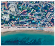
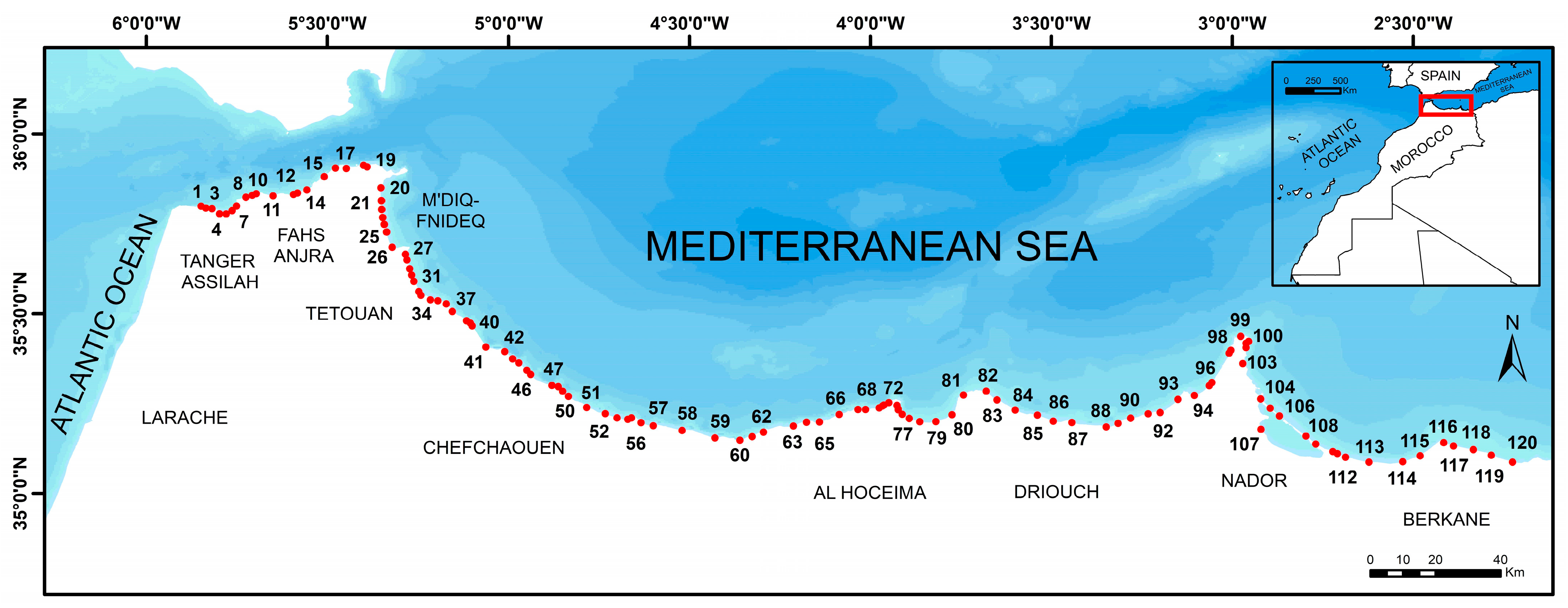
2. Study Area
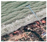
3. Methods
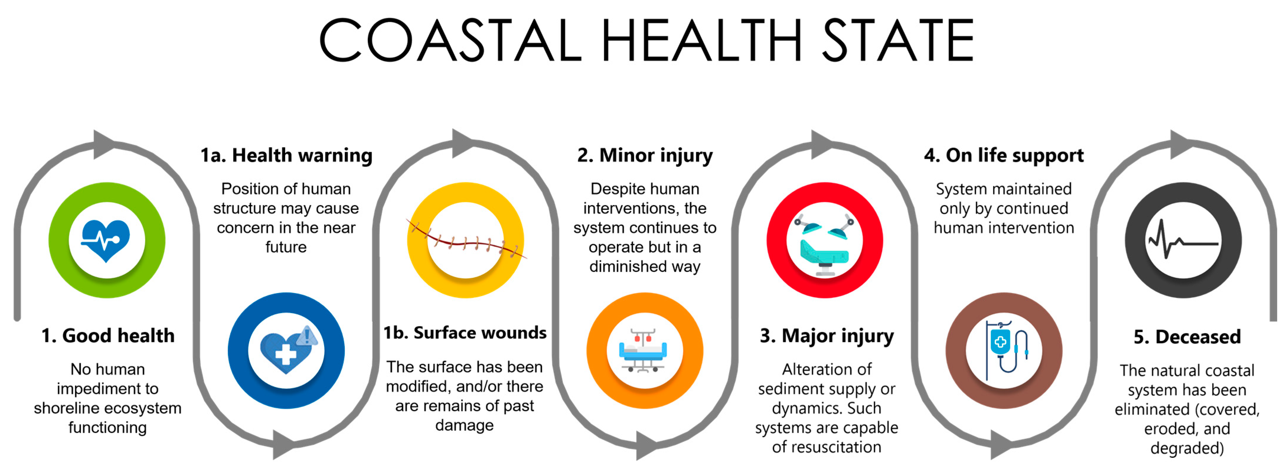
4. Results
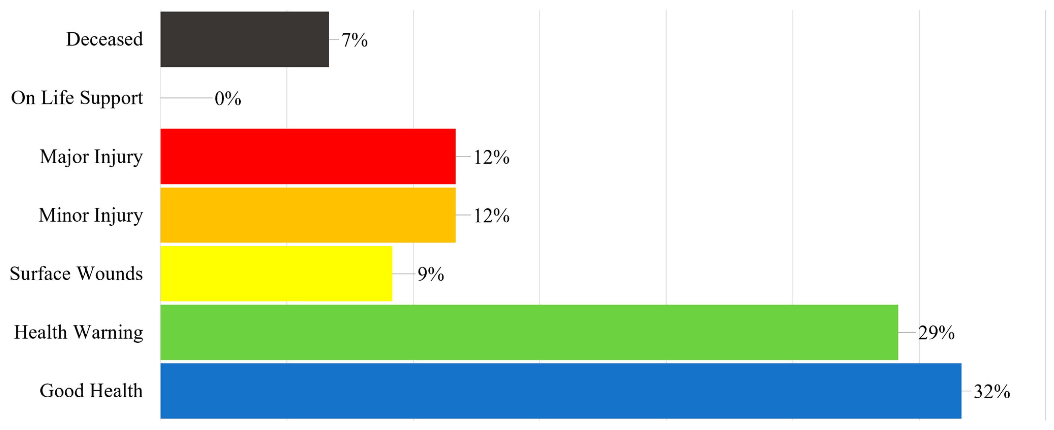
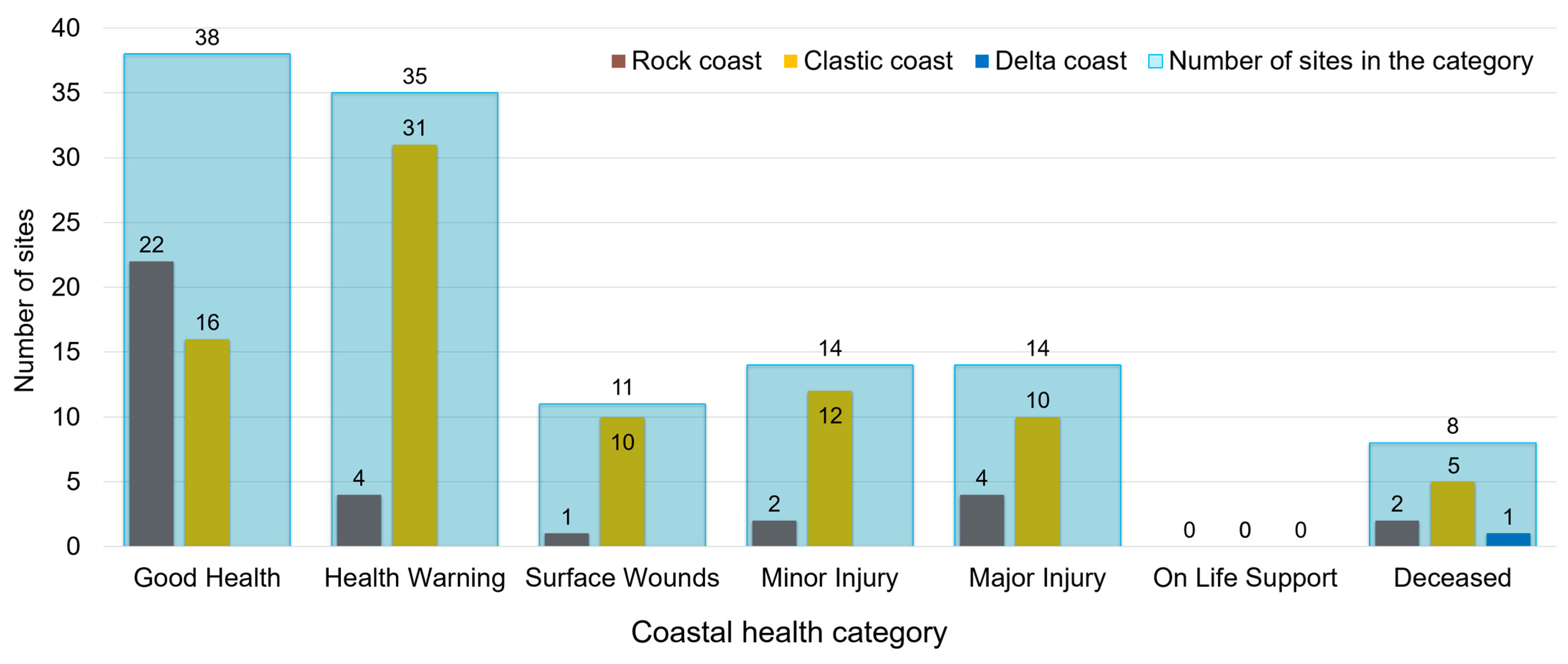
- “Good Health” Category
- “Health Warning” Category
- “Surface Wounds” Category
- “Minor Injury” Category
- “Major Injury” Category
- “Deceased” Category
5. Discussion
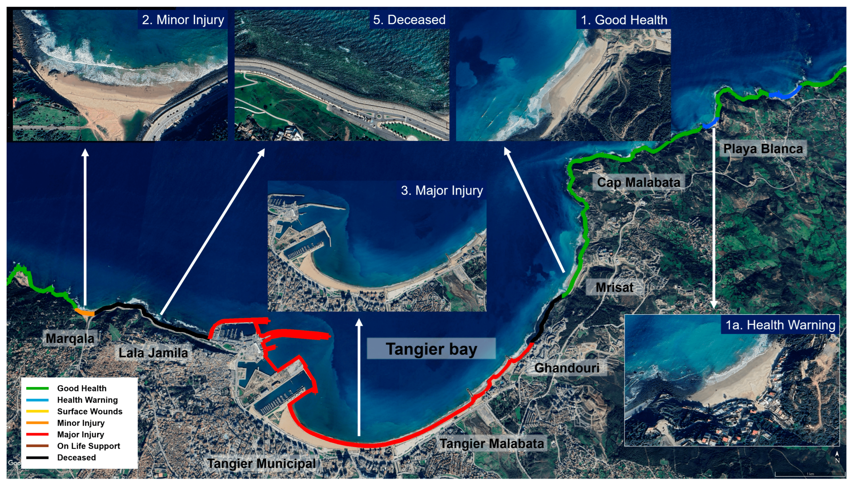
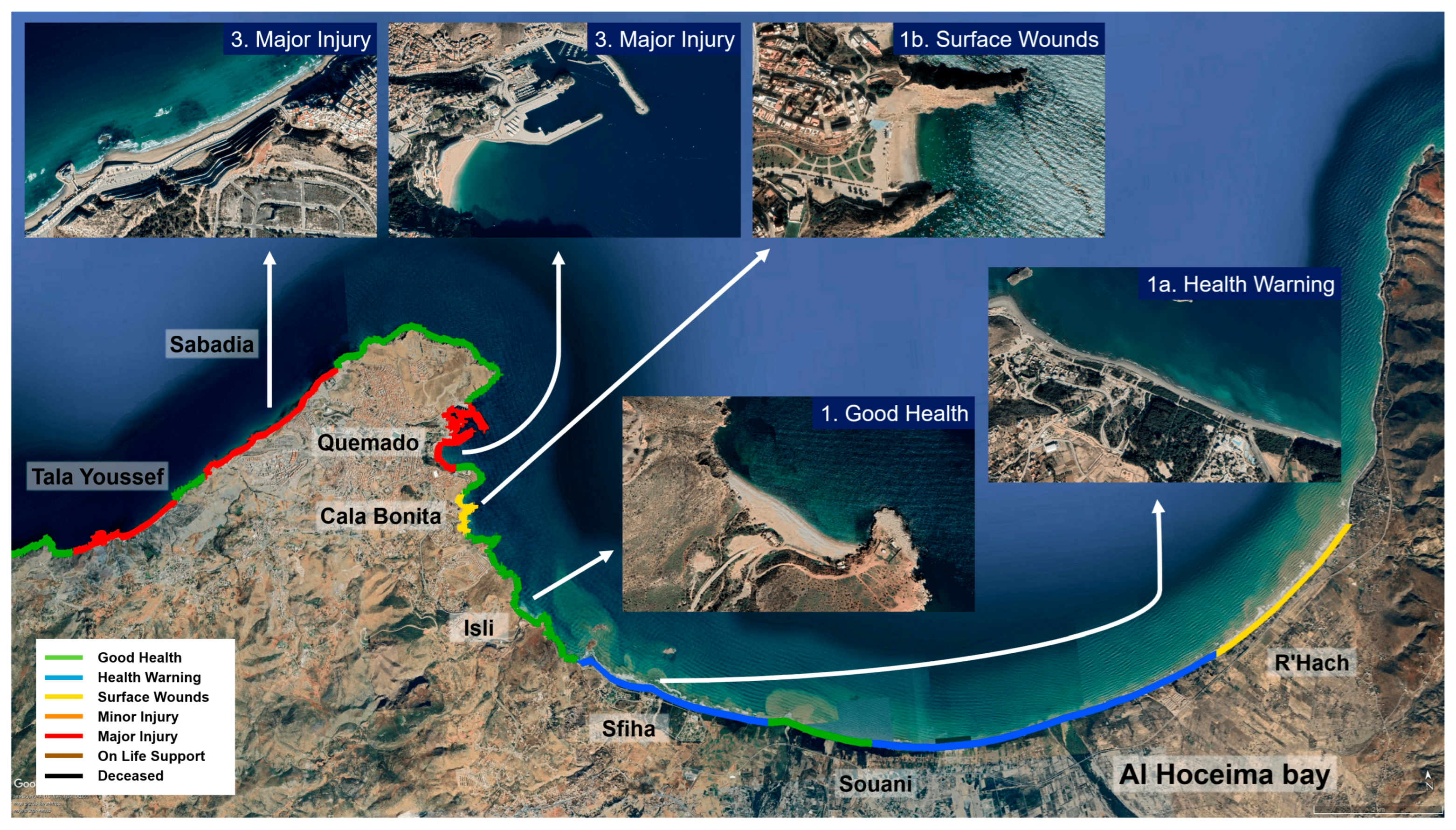
- For sites classified in the “Good Health” category, precautionary and conservation measures must be adopted to limit and control future coastal development and related human activities while ensuring the ecological integrity of the coastline is maintained. With this in mind, management efforts must focus on preserving, protecting, and enhancing natural coastal ecosystems and the natural features specific to each site along the coast. In addition, legal protection measures should be implemented by strengthening the legal and legislative framework for coastal protection to protect the health of the coastline and ensure its resilience to environmental and human constraints in the medium and long term. Sites such as Mrisat (Figure 5), Isli (Figure 6), Maresdar, Mina Rosita, Cala Blanca, etc., can benefit from this intervention to guarantee the preservation of their state of health and their natural aspect.
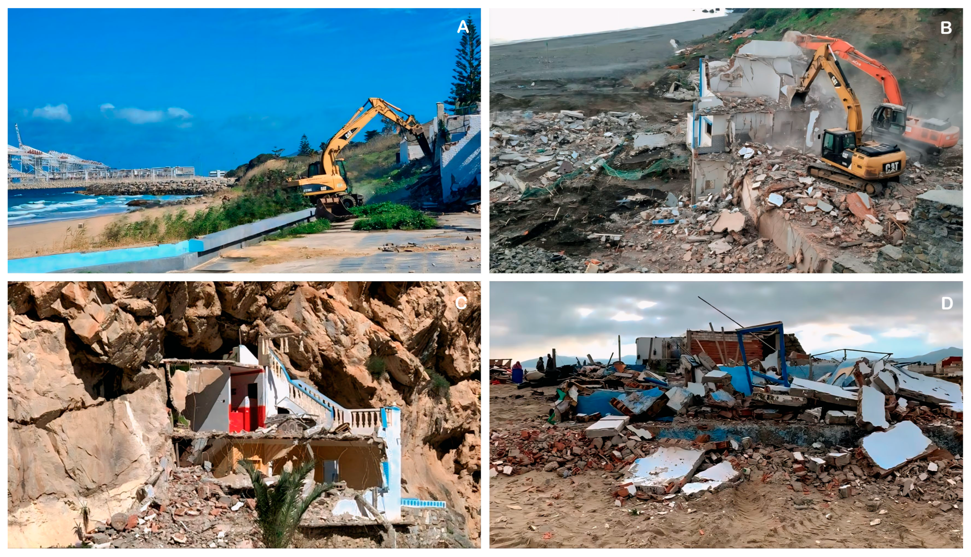
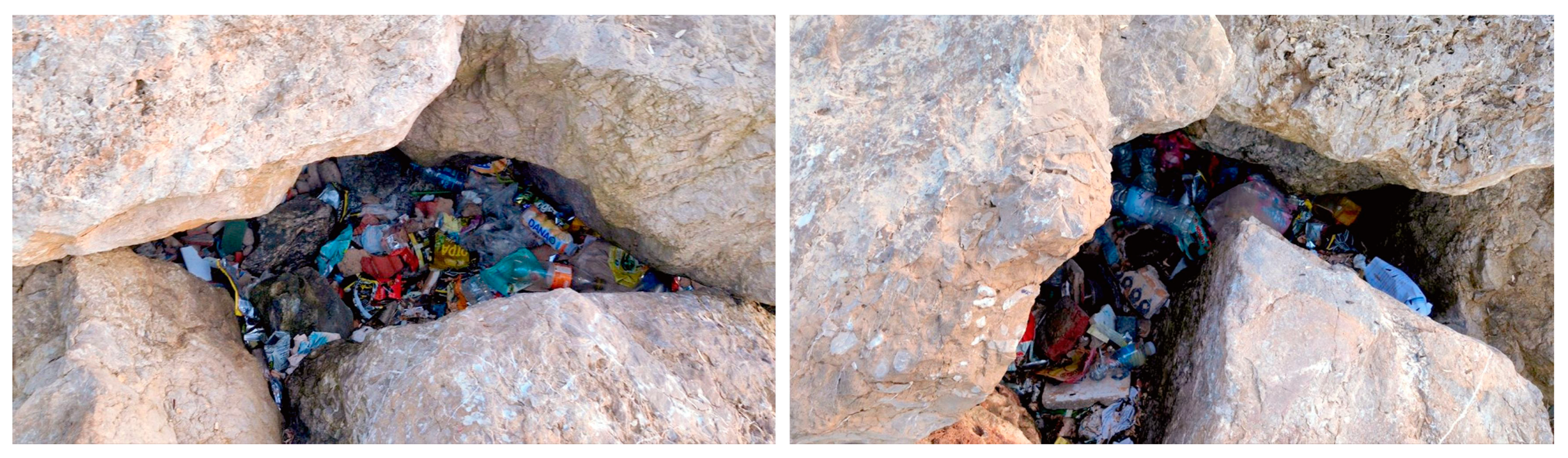
- For sites classified in the “Health Warning” and “Surface Wounds” sub-categories, coastal management measures should focus on the rehabilitation of lost ecological functions and the strict application of coastal laws to prevent ongoing and future deterioration. Along the Moroccan Mediterranean coast, strict management measures were implemented in 2024 to remove constructions such as buildings, tourist facilities, and commercial projects situated < 100 m from the sea, at the foot or edge of cliffs, or within active coastal systems (Figure 7). These constructions, which do not respect the ecological requirements and the preservation of coastal systems, have been demolished. Several sites examined as part of this research, some of which fall into these sub-categories, have benefited from this operation, with over 40 buildings demolished in some instances under this initiative at Sidi Kankouch, Oued Aliane, Aouchtam, Aarkoub, Jnan Nich Beach, etc. These proactive actions are part of a broader strategy to restore the ecological balance of the coastline, protect its natural functions, and maintain its ecological integrity over the long term. Indeed, the results obtained in this study demonstrate the effectiveness of these measures at certain sites, enabling improvements in the health of the coastline and enhancing the resilience of the Moroccan Mediterranean coast against anthropogenic pressures and coastal change. However, in coastal areas that are beginning to show signs of degradation, the preservation of the coastline is a major issue. Priority must be given to the maintenance and upkeep of the coastline through soft solutions, such as coastal dune restoration, beach nourishment, etc., rather than the emplacement of hard protection structures. The installation of anthropogenic protection structures in the future, as the first solution usually used in this case, would classify these sites in the “Major Injury” category, while environmental solutions could promote the regeneration of their state of health. From a coastal health perspective, protection structures alter coastal dynamics by disrupting natural sediment transport processes, affecting the sediment budget, the size and type of sediment particles, and, consequently, beach evolution, dune growth, and erosion patterns by significantly reducing beach width. These structures result in the loss of many coastal habitats, natural vegetation cover, and biodiversity of flora and fauna [81,82]. Protection structures occupy a significant part of the coastline, a natural area and active coastal system that, together with a series of associated ecological functions, will be permanently lost. Protection structures negatively affect coastal landscapes, favor the trapping and accumulation of woody debris and marine litter, and reduce the safety and comfort of beachgoers [73]. Woody debris and litter trapped by protection structures are widely seen along the sites surveyed (Figure 8). Soft solutions play a significant role in the sustainable management of coastal areas. They offer effective protection against dynamic forces and changing coastal conditions while preserving the natural quality of beaches, increasing beach width and providing space for recreational activities, as well as maintaining many services, thus ensuring greater socio-economic benefits for society.
- For sites classified as “Minor Injury” and “Major Injury”, management efforts are enormous as managing damaged natural coastal features is a considerable challenge, and their recovery is very costly. The management of the coastline becomes very complex due to the elevated level of human occupation. Although some human aspects influencing coastal health remain difficult to manage or remove, such as a large urban area and major infrastructures, e.g., ports and road networks, etc., some aspects are manageable, such as the presence of coastal protection structures. These protective structures could be dismantled or reduced, and beach nourishment projects implemented [83] to widen the beach, increase its carrying capacity, and therefore optimize its use for recreational purposes [84]. Such a solution has already been implemented in seaside tourist areas in Italy, Spain, Cuba, etc. [83,85]. Sites such as Tangier Municipal, Tangier Malabata, Ghandouri, Marqala (Figure 5), Sabadia, Quemado (Figure 6), etc., can benefit from this intervention and significantly improve their state of health. By implementing these health initiatives, these sites can improve their physical environments and also the well-being of their local communities. Moreover, sediments deposited up-drift of the structures often give rise to widespread beaches that can be exploited elsewhere to recharge other eroding coastal sectors [86]. Although Williams et al. [83] consider the removal of protective structures a complex approach and do not always present an economic advantage on the cost/benefit ratio, it remains a feasible choice. This choice, according to Rangel-Buitrago et al. [87], becomes necessary in some cases to improve beach quality and, in particular, the coastal landscape. In the present context, to protect the health of the coastline from additional anthropogenic aggression, the strengthening of the application of coastal laws is strongly desired. This involves strict restrictions on the development of new constructions and all kinds of unnecessary or superfluous human infrastructure. This approach can be seen as the most straightforward option to avoid future deterioration of coastal health. Furthermore, it is strongly recommended to consider and adopt management strategies focused on the ecological restoration, rehabilitation, and renaturation of the coastline.
- For sites classified as “On life support” and “Deceased”, recovery may not be possible. In the most favorable situation, only partial recovery is possible, allowing the coastal system to continue to function, albeit at a reduced level [45]. From a management perspective, in such situations, artificial habitats can be established, but they usually require regular maintenance and upkeep. However, these habitats, particularly in “Deceased” coastal systems, do not replace the original ecosystems and are not examples of coastal health restoration, as they are artificial substitutes that cannot function autonomously and require ongoing care. Such an intervention could be beneficial for sites such as Lalla Jamila (Figure 5), Azla promenade, Nador City, etc., for a partial recovery of the coast, given that their systems have been lost. In any case, the “do nothing” or “abandon” option cannot ever be chosen in such cases [88].
6. Conclusions
Author Contributions
Funding
Data Availability Statement
Acknowledgments
Conflicts of Interest
Appendix A

| Indicators | Good Health (Healthy Coastal Environments, no Coastal Squeeze) | Health Warning (The Health of Coastal Environments Is Slightly Menaced, Low Coastal Squeeze) | Surface Wounds (The Health of Coastal Environments Is Menaced, Medium-Low Coastal Squeeze) | Minor Injury (Coastal Environments Are Injured, Medium-Low Coastal Squeeze) | Major Injury (Unhealthy Coastal Environments, High Coastal Squeeze) | On Life Support (Coastal Environments Heavily Affected, Very High Coastal Squeeze) | Deceased (Coastal Environments Disappeared, Very High Coastal Squeeze) |
| Presence in the active beach–dune system of human activities and constructions, essentially coastal protection structures and marinas/ports’ infrastructures that may constitute obstacles to the sediment transport and supply, i.e., to the natural cross- and long-shore movement of sediments and, therefore, to the natural coastal evolution |
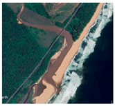 Natural area free of structures, KwaZulu-Natal Coast, South Africa. |
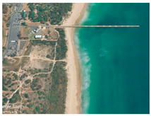 A pier slightly affecting alongshore transport, Gold Coast, Queensland, Australia. |
 Small groins partially stabilize the beach but do not completely stop longshore transport, Balanegra Beach, Almeria, Spain. |
 Groin stopping alongshore transport, Puerto Banus. Marbella, Spain. |
 Breakwaters and groins interrupt coastal longshore transport and sediment dynamics at Donnalucata, Ragusa, Italy. |
 Eroding beach that needs continuous nourishment works and groins to retain the placed sand, Golden Mile Beach, Durban, South Africa. |
 Cliffed coastal stretch protected by a rip-rap revetment, San Vito Chietino, Abruzzo, Italy. |
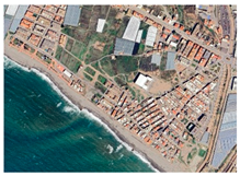
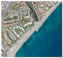
| Presence in the area behind the beach–dune system of human settlements and activities. Such activities/structures could potentially affect in a near future the natural coastal evolution |
 Natural area free of human activities/settlements, Bay of Ieranto, Naples, Italy. |
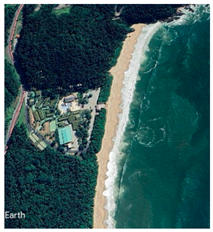 Human settlements far from the coastline, Hole Beach, Balneario Camboriu, Brazil. |
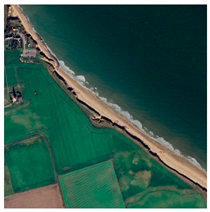 Agricultural activities close to the coastline, but no human settlements are observed, Happisburgh Beach, Norwich, UK. |
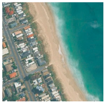 Urban development close to the coast may be impacted by erosion processes in the future, Palm Beach, Queensland, Australia. |
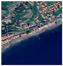 Very urbanized area on the top of a slightly retreating basaltic cliff, Aci Castello, Sicily, Italy. |
 Very urbanized area in front of a beach that is maintained by continuous nourishment works, Benidorm, Alicante, Spain. |
 Urbanized area in a very retreating coast with no protection structures, Monitos, Monteria, Colombia. |
| N° | Site | Type | Coastal Health Category | Geographic Coordinates | |
|---|---|---|---|---|---|
| 1 | Zahani | Rock coast | Good health | 35°47′58.64″ N | 5°50′49.32″ O |
| 2 | Marqala | Rock coast | Minor Injury | 35°47′39.25″ N | 5°50′3.84″ O |
| 3 | Lalla Jamila | Clastic coast | Deceased | 35°47′32.24″ N | 5°49′11.44″ O |
| 4 | Tangier Municipal | Clastic coast | Major Injury | 35°46′43.27″ N | 5°47′50.27″ O |
| 5 | Tangier Malabata | Clastic coast | Major Injury | 35°46′40.48″ N | 5°46′42.59″ O |
| 6 | Ghandouri | Clastic coast | Major Injury | 35°47′17.90″ N | 5°45′39.57″ O |
| 7 | Mrisat | Clastic coast | Good health | 35°47′58.64″ N | 5°45′3.45″ O |
| 8 | Playa Blanca | Rock coast | Health warning | 35°49′28.04″ N | 5°45′3.45″ O |
| 9 | Sidi Kankouche 1 | Clastic coast | Health warning | 35°49′46.36″ N | 5°42′26.27″ O |
| 10 | Sidi Kankouche 2 | Clastic coast | Good health | 35°49′53.81″ N | 5°42′4.29″ O |
| 11 | Oued Aliane | Clastic coast | Health warning | 35°49′38.94″ N | 5°38′57.67″ O |
| 12 | Dikki | Clastic coast | Health warning | 35°49′55.95″ N | 5°35′31.64″ O |
| 13 | Zahara | Clastic coast | Surface Wounds | 35°50′9.40″ N | 5°34′54.54″ O |
| 14 | Ksar Sghir | Clastic coast | Major Injury | 35°50′40.13″ N | 5°33′20.06″ O |
| 15 | Oued Rmel | Clastic coast | Deceased | 35°53′15.42″ N | 5°29′46.04″ O |
| 16 | Dalya | Clastic coast | Minor Injury | 35°54′19.55″ N | 5°28′36.24″ O |
| 17 | Oued El Marsa | Clastic coast | Good health | 35°54′14.22″ N | 5°26′37.35″ O |
| 18 | Belyounech 2 | Rock coast | Surface Wounds | 35°54′40.09″ N | 5°23′49.31″ O |
| 19 | Belyounech 1 | Clastic coast | Minor Injury | 35°54′33.51″ N | 5°23′36.13″ O |
| 20 | Fnideq | Clastic coast | Deceased | 35°51′2.67″ N | 5°21′4.84″ O |
| 21 | Rifienne | Clastic coast | Health warning | 35°48′31.48″ N | 5°21′4.63″ O |
| 22 | Almina | Clastic coast | Health warning | 35°47′30.64″ N | 5°20′58.81″ O |
| 23 | Restinga | Clastic coast | Health warning | 35°45′54.96″ N | 5°20′44.10″ O |
| 24 | Marina Smir | Clastic coast | Minor Injury | 35°44′56.25″ N | 5°20′32.63″ O |
| 25 | Kabila | Clastic coast | Minor Injury | 35°43′36.69″ N | 5°20′16.36″ O |
| 26 | M’Diq | Clastic coast | Major Injury | 35°41′0.91″ N | 5°19′11.78″ O |
| 27 | Cabo Negro 1 | Rock coast | Minor Injury | 35°40′5.91″ N | 5°16′59.62″ O |
| 28 | Cabo Negro 2 | Clastic coast | Health warning | 35°38′41.72″ N | 5°16′44.37″ O |
| 29 | Martil | Clastic coast | Surface Wounds | 35°37′32.40″ N | 5°16′20.80″ O |
| 30 | Martil Diza | Clastic coast | Minor Injury | 35°36′33.84″ N | 5°16′5.50″ O |
| 31 | Sidi Abdeslam | Clastic coast | Good health | 35°35′25.63″ N | 5°15′39.90″ O |
| 32 | Azla promenade | Rock coast | Deceased | 35°33′42.43″ N | 5°14′51.41″ O |
| 33 | Azla Beach | Clastic coast | Surface Wounds | 35°33′5.39″ N | 5°14′30.98″ O |
| 34 | Amsa | Clastic coast | Surface Wounds | 35°32′26.80″ N | 5°13′4.04″ O |
| 35 | Tamrabet | Clastic coast | Health warning | 35°32′11.50″ N | 5°11′42.01″ O |
| 36 | Tamernout | Clastic coast | Health warning | 35°31′39.56″ N | 5°10′18.30″ O |
| 37 | Aouchtam | Clastic coast | Health warning | 35°30′24.02″ N | 5°9′17.31″ O |
| 38 | Yellow Rock Beach | Rock coast | Good health | 35°28′48.63″ N | 5°6′52.47″ O |
| 39 | Oued Laou-Mekkad | Clastic coast | Health warning | 35°28′25.55″ N | 5°6′16.93″ O |
| 40 | Oued Laou-Center | Clastic coast | Health warning | 35°27′56.38″ N | 5°5′58.68″ O |
| 41 | Kaa Asrass | Clastic coast | Surface Wounds | 35°24′27.29″ N | 5°3′44.35″ O |
| 42 | Targha | Clastic coast | Health warning | 35°23′40.01″ N | 5°0′36.16″ O |
| 43 | Azenti | Clastic coast | Good health | 35°22′28.14″ N | 4°59′17.93″ O |
| 44 | Stehat 2 | Clastic coast | Good health | 35°21′32.48″ N | 4°58′1.19″ O |
| 45 | Stehat 1 | Clastic coast | Surface Wounds | 35°20′41.84″ N | 4°57′8.25″ O |
| 46 | Chmaala | Clastic coast | Minor Injury | 35°19′51.45″ N | 4°56′19.02″ O |
| 47 | Sidi Yahya Aarab | Clastic coast | Minor Injury | 35°18′1.41″ N | 4°52′47.61″ O |
| 48 | Jnan Nich Islands | Rock coast | Good health | 35°17′49.20″ N | 4°51′44.49″ O |
| 49 | Jnan Nich Beach | Clastic coast | Health warning | 35°17′2.33″ N | 4°50′59.65″ O |
| 50 | Aarkoub | Clastic coast | Health warning | 35°16′11.97″ N | 4°50′1.98″ O |
| 51 | Amtar | Clastic coast | Surface Wounds | 35°14′25.02″ N | 4°47′7.97″ O |
| 52 | Taghassa | Clastic coast | Health warning | 35°13′19.10″ N | 4°43′56.82″ O |
| 53 | Rouiss | Clastic coast | Good health | 35°12′36.29″ N | 4°42′0.33″ O |
| 54 | Jebha-Port | Rock coast | Deceased | 35°12′19.60″ N | 4°40′23.47″ O |
| 55 | Jebha-Maresdar | Rock coast | Good health | 35°12′35.42″ N | 4°39′29.64″ O |
| 56 | Jebha-El Hwad | Clastic coast | Good health | 35°12′26.32″ N | 4°38′43.45″ O |
| 57 | Takmout | Clastic coast | Health warning | 35°11′15.21″ N | 4°36′8.86″ O |
| 58 | Sidi Ftouh | Clastic coast | Health warning | 35°10′30.63″ N | 4°31′11.51″ O |
| 59 | Mestassa | Clastic coast | Health warning | 35°9′16.52″ N | 4°25′45.88″ O |
| 60 | Cala Iris | Rock coast | Major Injury | 35°8′52.89″ N | 4°21′37.35″ O |
| 61 | Torres Alcala | Rock coast | Good health | 35°9′26.93″ N | 4°19′38.68″ O |
| 62 | Bades | Clastic coast | Health warning | 35°10′13.48″ N | 4°17′42.12″ O |
| 63 | Tigzirin | Rock coast | Good health | 35°11′15.02″ N | 4°12′45.48″ O |
| 64 | Boumeksoud | Rock coast | Good health | 35°11′52.18″ N | 4°10′34.58″ O |
| 65 | Thikkit | Rock coast | Good health | 35°11′55.92″ N | 4°8′25.22″ O |
| 66 | Taoussarte | Rock coast | Good health | 35°13′10.07″ N | 4°5′9.37″ O |
| 67 | Boussekour | Clastic coast | Health warning | 35°14′0.31″ N | 4°2′3.27″ O |
| 68 | Boumehdi | Rock coast | Good health | 35°13′59.57″ N | 4°0′47.85″ O |
| 69 | Tala Youssef | Clastic coast | Major Injury | 35°14′16.56″ N | 3°58′32.29″ O |
| 70 | Rmod | Rock coast | Major Injury | 35°14′36.78″ N | 3°57′57.25″ O |
| 71 | Izdhi | Rock coast | Major Injury | 35°14′43.10″ N | 3°57′46.49″ O |
| 72 | Sabadia | Clastic coast | Major Injury | 35°14′57.25″ N | 3°57′14.81″ O |
| 73 | Quemado | Clastic coast | Major Injury | 35°14′40.22″ N | 3°55′34.33″ O |
| 74 | Matadero | Clastic coast | Surface Wounds | 35°14′11.88″ N | 3°55′23.95″ O |
| 75 | Cala Bonita | Clastic coast | Surface Wounds | 35°14′4.14″ N | 3°55′22.78″ O |
| 76 | Isli | Clastic coast | Good health | 35°13′9.89″ N | 3°54′45.99″ O |
| 77 | Sfiha | Clastic coast | Health warning | 35°12′37.46″ N | 3°54′0.10″ O |
| 78 | Souani Al Hoceima | Clastic coast | Good health | 35°11′57.82″ N | 3°51′48.76″ O |
| 79 | Souani Driouch | Clastic coast | Health warning | 35°12′1.76″ N | 3°48′51.26″ O |
| 80 | R’Hach | Clastic coast | Surface Wounds | 35°13′6.71″ N | 3°46′30.91″ O |
| 81 | Ifri Ithbiran | Rock coast | Good health | 35°16′25.62″ N | 3°44′34.34″ O |
| 82 | Hrizou | Rock coast | Good health | 35°17′4.45″ N | 3°40′47.66″ O |
| 83 | Agharabo Yarzan | Clastic coast | Health warning | 35°15′32.05″ N | 3°38′53.88″ O |
| 84 | Sidi Driss | Clastic coast | Health warning | 35°13′53.18″ N | 3°35′57.31″ O |
| 85 | Sidi Salah | Clastic coast | Health warning | 35°13′4.14″ N | 3°32′23.46″ O |
| 86 | Sidi Amer O Moussa | Clastic coast | Health warning | 35°11′59.16″ N | 3°29′30.21″ O |
| 87 | Sidi Hssaine | Clastic coast | Minor Injury | 35°11′49.18″ N | 3°26′33.52″ O |
| 88 | Chaabi | Rock coast | Good health | 35°11′6.14″ N | 3°20′54.80″ O |
| 89 | Ghansou | Rock coast | Good health | 35°12′1.36″ N | 3°18′29.38″ O |
| 90 | Sidi Boussaid | Rock coast | Good health | 35°12′36.56″ N | 3°16′28.31″ O |
| 91 | Ifri Ifounassen | Rock coast | Major Injury | 35°13′17.15″ N | 3°13′55.71″ O |
| 92 | Boundouha | Clastic coast | Major Injury | 35°13′25.13″ N | 3°12′4.21″ O |
| 93 | El-Kallat | Clastic coast | Good health | 35°15′42.72″ N | 3°8′56.95″ O |
| 94 | Sidi Lehsen | Clastic coast | Health warning | 35°16′20.90″ N | 3°6′17.28″ O |
| 95 | Playa de las Japonesas | Rock coast | Good health | 35°17′58.17″ N | 3°3′47.46″ O |
| 96 | Marsa Yawyan | Rock coast | Good health | 35°18′28.87″ N | 3°3′22.34″ O |
| 97 | Charrana 1 | Clastic coast | Health warning | 35°23′22.69″ N | 3°0′29.49″ O |
| 98 | Charrana 2 | Clastic coast | Good health | 35°23′56.24″ N | 3°0′12.56″ O |
| 99 | Cape Three Forks | Rock coast | Good health | 35°26′18.81″ N | 2°58′21.64″ O |
| 100 | Tibouda | Rock coast | Health warning | 35°25′22.28″ N | 2°57′15.94″ O |
| 101 | Tibouda 2 | Rock coast | Health warning | 35°25′4.85″ N | 2°57′41.40″ O |
| 102 | Mina Rosita | Clastic coast | Good health | 35°24′21.01″ N | 2°57′40.66″ O |
| 103 | Cala Blanca | Rock coast | Good health | 35°21′20.84″ N | 2°57′53.94″ O |
| 104 | Miami | Clastic coast | Major Injury | 35°15′43.79″ N | 2°55′15.37″ O |
| 105 | Boqueronesa West | Clastic coast | Good health | 35°14′14.07″ N | 2°53′41.43″ O |
| 106 | Boqueronesa East | Clastic coast | Minor Injury | 35°12′55.95″ N | 2°52′9.71″ O |
| 107 | Nador City | Clastic coast | Deceased | 35°10′41.30″ N | 2°55′13.82″ O |
| 108 | Al Mouhandis | Clastic coast | Health warning | 35°9′34.71″ N | 2°47′46.67″ O |
| 109 | Taourirt | Clastic coast | Good health | 35°7′51.55″ N | 2°45′29.68″ O |
| 110 | Kariat Arekmane | Clastic coast | Health warning | 35°6′54.95″ N | 2°43′12.46″ O |
| 111 | Blue Eye Beach | Clastic coast | Deceased | 35°6′38.42″ N | 2°42′31.36″ O |
| 112 | Jorf Arroum | Rock coast | Good health | 35°6′2.28″ N | 2°41′12.11″ O |
| 113 | El Jamai | Rock coast | Health warning | 35°5′12.85″ N | 2°37′19.65″ O |
| 114 | Sidi El Bachir | Rock coast | Good health | 35°5′16.87″ N | 2°31′45.86″ O |
| 115 | Red Beach | Rock coast | Good health | 35°6′10.50″ N | 2°29′6.48″ O |
| 116 | Ras El Ma | Clastic coast | Minor Injury | 35°8′25.24″ N | 2°24′54.13″ O |
| 117 | Kamkoum El Baz | Clastic coast | Good health | 35°7′56.66″ N | 2°23′26.64″ O |
| 118 | Mouth of Oued Moulouya | Delta coast | Deceased | 35°7′18.38″ N | 2°20′0.41″ O |
| 119 | Saïdia Med East | Clastic coast | Minor Injury | 35°6′21.45″ N | 2°17′2.88″ O |
| 120 | Saïdia | Clastic coast | Minor Injury | 35°5′13.66″ N | 2°13′30.63″ O |
References
- Bird, E. Coastal Geomorphology: An Introduction; John Wiley & Sons: Hoboken, NJ, USA, 2011. [Google Scholar]
- Pilkey, O.H.; Cooper, J.A.G. Are Natural Beaches Facing Extinction? J. Coast. Res. 2014, 70, 431–436. [Google Scholar] [CrossRef]
- Carter, R.W.G. Coastal Environments, An Introduction to the Physical, Ecological and Cultural Systems of Coastlines; Academic Press: London, UK, 1988. [Google Scholar]
- Martínez, M.L.; Intralawan, A.; Vázquez, G.; Pérez-Maqueo, O.; Sutton, P.; Landgrave, R. The coasts of our world: Ecological, economic and social importance. Ecol. Econ. 2007, 63, 254–272. [Google Scholar] [CrossRef]
- Seitz, R.D.; Wennhage, H.; Bergström, U.; Lipcius, R.N.; Ysebaert, T. Ecological value of coastal habitats for commercially and ecologically important species. ICES J. Mar. Sci. J. Cons. 2014, 71, 648–665. [Google Scholar] [CrossRef]
- Henseler, C.; Nordström, M.C.; Törnroos, A.; Snickars, M.; Pecuchet, L.; Lindegren, M.; Bonsdorff, E. Coastal habitats and their importance for the diversity of benthic communities: A species-and trait-based approach. Estuar. Coast. Shelf Sci. 2019, 226, 106272. [Google Scholar] [CrossRef]
- Pilkey, O.H.; Neal, W.J.; Kelley, J.T.; Cooper, J.A.G. The World’s Beaches: A Global Guide to the Science of the Shoreline; University of California Press: Berkeley, CA, USA, 2011. [Google Scholar]
- Jackson, D.W.T.; Short, A. Sandy Beach Morphodynamics; Elsevier: Amsterdam, The Netherlands, 2020; p. 793. [Google Scholar]
- Defeo, O.; Licandro, J.A.; Olalde, J.; Bausero-Jorcin, S.; Celentano, E.; De Álava, A.; Jorge-Romero, G.; Lercari, D.; Rangel-Buitrago, N. Assessing the health and scenic quality of sandy beaches: A large-scale evaluation using expert judgement. Ocean Coast. Manag. 2024, 259, 107468. [Google Scholar] [CrossRef]
- Lopez-Rivas, J.D.; Cardenas, J.-C. What is the economic value of coastal and marine ecosystem services? A systematic literature review. Mar. Policy 2024, 161, 106033. [Google Scholar] [CrossRef]
- Barbier, E.B.; Hacker, S.D.; Kennedy, C.; Koch, E.W.; Stier, A.C.; Silliman, B.R. The value of estuarine and coastal ecosystem services. Ecol. Monogr. 2010, 81, 169–193. [Google Scholar] [CrossRef]
- Drius, M.; Jones, L.; Marzialetti, F.; De Francesco, M.C.; Stanisci, A.; Carranza, M.L. Not just a sandy beach. The multi-service value of Mediterranean coastal dunes. Sci. Total Environ. 2019, 668, 1139–1155. [Google Scholar] [CrossRef]
- Harris, L.R.; Defeo, O. Sandy shore ecosystem services, ecological infrastructure, and bundles: New insights and perspectives. Ecosyst. Serv. 2022, 57, 101477. [Google Scholar] [CrossRef]
- Liquete, C.; Piroddi, C.; Drakou, E.G.; Gurney, L.; Katsanevakis, S.; Charef, A.; Egoh, B. Current status and future prospects for the assessment of marine and coastal ecosystem services: A systematic review. PLoS ONE 2013, 8, e67737. [Google Scholar] [CrossRef]
- Beaumont, N.J.; Aanesen, M.; Austen, M.C.; Börger, T.; Clark, J.R.; Cole, M.; Hooper, T.; Lindeque, P.K.; Pascoe, C.; Wyles, K.J. Global ecological, social and economic impacts of marine plastic. Mar. Pollut. Bull. 2019, 142, 189–195. [Google Scholar] [CrossRef] [PubMed]
- McLachlan, A.; Defeo, O. Where will the children play? A personal perspective on sandy beaches. Estuar. Coast. Shelf Sci. 2023, 280, 108186. [Google Scholar] [CrossRef]
- Enriquez-Acevedo, T.; Botero, C.M.; Cantero-Rodelo, R.; Pertuz, A.; Suarez, A. Willingness to pay for Beach Ecosystem Services: The case study of three Colombian beaches. Ocean. Coast. Manag. 2018, 161, 96–104. [Google Scholar] [CrossRef]
- Rangel-Buitrago, N.; Velez-Mendoza, A.; Gracia, C.A.; Neal, W.J. The impact of anthropogenic litter on Colombia’s central Caribbean beaches. Mar. Pollut. Bull. 2020, 152, 110909. [Google Scholar] [CrossRef]
- Kaltenborn, B.P.; Linnell, J.D.; Gómez-Baggethun, E. Can cultural ecosystem services contribute to satisfying basic human needs? A case study from the Lofoten archipelago, northern Norway. Appl. Geogr. 2020, 120, 102229. [Google Scholar] [CrossRef]
- Shasha, L.; Feng, C.; Hongshuai, Q.; Jianhui, L.; Wei, Y.; Gen, L. Economic contribution of beach resources and their sustainable development in China. Ocean Coast. Manag. 2023, 239, 106598. [Google Scholar] [CrossRef]
- Portz, L.; Manzolli, R.P.; Hermanns, L.; Alcántara Carrió, J. Evaluation of the efficiency of dune reconstruction techniques in Xangri-Lá (Rio Grande Do Sul, Brazil). Ocean. Coast. Manag. 2015, 104, 78–89. [Google Scholar] [CrossRef]
- Defeo, O.; McLachlan, A.; Armitage, D.; Elliott, M.; Pittman, J. Sandy beach social–ecological systems at risk: Regime shifts, collapses, and governance challenges. Front. Ecol. Environ. 2021, 19, 564–573. [Google Scholar] [CrossRef]
- Alharbi, O.A.; Rangel-Buitrago, N. Landscape degradation in the Jazan coastal desert: Understanding the impact of human activities. Mar. Pollut. Bull. 2023, 190, 114874. [Google Scholar] [CrossRef]
- Corraini, N.R.; Rangel-Buitrago, N.; Scherer, M.E.G. Where to start? Ranking priority areas for shoreline management on Santa Catarina Island, Brazil. Ocean Coast. Manag. 2025, 261, 107536. [Google Scholar] [CrossRef]
- Davidson-Arnott, R. An Introduction to Coastal Processes and Geomorphology; Cambridge University Press: Cambridge, UK, 2010. [Google Scholar]
- Ramesh, R.; Chen, Z.; Cummins, V.; Day, J.; D’Elia, C.; Dennison, B.; Forbes, D.L.; Glaeser, B.; Glaser, M.; Glavovic, B.; et al. Land–Ocean Interactions in the Coastal Zone: Past, present & future. Anthropocene 2015, 12, 85–98. [Google Scholar] [CrossRef]
- Alemayehu, F.; Richard, O.; James, K.M.; Wasonga, O. Assessment of Mangrove Covers Change and Biomass in Mida creek, Kenya. Open J. For. 2014, 04, 398–413. [Google Scholar] [CrossRef]
- Tian, H.; Xu, K.; Goes, J.I.; Liu, Q.; Gomes, H.D.R.; Yang, M. Shoreline changes along the coast of mainland China—Time to pause and reflect? ISPRS Int. J. Geo-Inf. 2020, 9, 572. [Google Scholar] [CrossRef]
- Fant, C.; Gentile, L.E.; Herold, N.; Kunkle, H.; Kerrich, Z.; Neumann, J.; Martinich, J. Valuation of long-term coastal wetland changes in the U.S. Ocean Coast. Manag. 2022, 226, 106248. [Google Scholar] [CrossRef] [PubMed]
- Chadwick, A.; Weston, M.A.; Burns, T.; Randall, G.; Radvan, M.; Rendall, A.R. Natural and anthropogenic processes influence the occurrence of vertebrate fauna in coastal dunes. Estuar. Coast. Shelf Sci. 2022, 276, 108025. [Google Scholar] [CrossRef]
- Bombino, G.; Barbaro, G.; D’Agostino, D.; Denisi, P.; Foti, G.; Labate, A.; Zimbone, S.M. Shoreline change and coastal erosion: The role of check dams. First indications from a case study in Calabria, southern Italy. CATENA 2022, 217, 106494. [Google Scholar] [CrossRef]
- Cai, F.; Cao, C.; Qi, H.; Su, X.; Lei, G.; Liu, J.; Zhao, S.; Liu, G.; Zhu, K. Rapid migration of mainland China’s coastal erosion vulnerability due to anthropogenic changes. J. Environ. Manag. 2022, 319, 115632. [Google Scholar] [CrossRef]
- Mishra, P.; Kaviarasan, T.; Sambandam, M.; Dhineka, K.; Murthy, M.R.; Iyengar, G.; Singh, J.; Ravichandran, M. Assessment of national beach litter composition, sources, and management along the Indian coast-a citizen science approach. Mar. Pollut. Bull. 2023, 186, 114405. [Google Scholar] [CrossRef]
- He, Q.; Silliman, B.R. Climate change, human impacts, and coastal ecosystems in the anthropocene. Curr. Biol. 2019, 29, R1021–R1035. [Google Scholar] [CrossRef]
- Ballantyne, J.A.; Henderson, C.J.; Olds, A.D.; Schlacher, T.A.; Elliott, B.B.; Gilby, B.L. Cross-boundary effects of human impacts on animal assemblages in the coastal zone. Biodivers. Conserv. 2024, 33, 3039–3055. [Google Scholar] [CrossRef]
- Tett, P.; Gowen, R.; Painting, S.; Elliott, M.; Forster, R.; Mills, D.; Bresnan, E.; Capuzzo, E.; Fernandes, T.; Foden, J.; et al. Framework for understanding marine ecosystem health. Mar. Ecol. Prog. Ser. 2013, 494, 1–27. [Google Scholar] [CrossRef]
- Costanza, R.; Norton, B.G.; Haskell, B.D. Ecosystem Health: New Goals for Environmental Management; Island Press: Washington, DC, USA, 1992. [Google Scholar]
- Aronson, J.; Milton, S.J.; Blignaut, J.N. Restoring Natural Capital: Science, Business, and Practice; Island Press-SER: Washington, DC, USA, 2007. [Google Scholar]
- de Groot, R. 12.02-What are Ecosystem Services? In Treatise on Estuarine and Coastal Science; Wolanski, E., McLusky, D., Eds.; Elsevier Inc.; Academic Press: Waltham, MA, USA, 2011; pp. 15–34. [Google Scholar] [CrossRef]
- Albrecht, G.A.; Higginbotham, N.; Connor, L.; Ellis, N. Social and cultural perspectives on ecology and health. In International Encyclopedia of Public Health, 2nd ed.; Quah, S.R., Cockerham, W.C., Eds.; Elsevier Inc.; Academic Press: Waltham, MA, USA, 2017; pp. 551–556. [Google Scholar] [CrossRef]
- Burkhard, B.; Müller, F.; Lill, A. Ecosystem Health Indicators. In Encyclopedia of Ecology; Jorgensen, S.E., Fath, B.D., Eds.; Academic Press: Oxford, UK, 2008; pp. 1132–1138. [Google Scholar] [CrossRef]
- Kruse, M. Ecosystem Health Indicators. Encycl. Ecol. 2019, 1, 407–414. [Google Scholar] [CrossRef]
- Rapport, D.J.; Gaudet, C.L.; Calow, P. Evaluating and Monitoring the Health of Large-Scale Ecosystems; NATO ASI Series; Springer: Berlin/Heidelberg, Germany, 1995. [Google Scholar]
- Economic, Social and Environmental Council. What Urban Dynamics For Sustainable Coastal Development? Opinion of the Economic, Social and Environmental Council. Rabat, Morocco; 42p. Available online: https://www.cese.ma/media/2022/09/Avis-littoral-VF.pdf (accessed on 2 June 2025).
- Cooper, J.A.G.; Jackson, D.W.T. Coasts in Peril? A shoreline health perspective. Front. Earth Sci. 2019, 7, 260. [Google Scholar] [CrossRef]
- Er-Ramy, N.; Nachite, D.; Anfuso, G.; Azaaouaj, S. A Novelty Methodological Approach to Coastal Scenic Quality Evaluation—Application to the Moroccan Mediterranean Coast. J. Mar. Sci. Eng. 2023, 11, 953. [Google Scholar] [CrossRef]
- Nachite, D.; Maziane, F.; Anfuso, G.; Williams, A.T. Spatial and temporal variations of litter at the Mediterranean beaches of Morocco mainly due to beach users. Ocean Coast. Manag. 2019, 179, 104846. [Google Scholar] [CrossRef]
- Azaaouaj, S.; Nachite, D.; Anfuso, G.; Er-Ramy, N. Abundance and distribution of microplastics on sandy beaches of the eastern Moroccan Mediterranean coast. Mar. Pollut. Bull. 2024, 200, 116144. [Google Scholar] [CrossRef]
- Azaaouaj, S.; Er-Ramy, N.; Nachite, D.; Anfuso, G. Presence, Spatial Distribution, and Characteristics of Microplastics in Beach Sediments Along the Northwestern Moroccan Mediterranean Coast. Water 2025, 17, 1646. [Google Scholar] [CrossRef]
- Krikech, I.; Conti, G.O.; Pulvirenti, E.; Rapisarda, P.; Castrogiovanni, M.; Maisano, M.; Le Pennec, G.; Leermakers, M.; Ferrante, M.; Cappello, T.; et al. Microplastics (≤10 μm) bioaccumulation in marine sponges along the Moroccan Mediterranean coast: Insights into species-specific distribution and potential bioindication. Environ. Res. 2023, 235, 116608. [Google Scholar] [CrossRef]
- von Thenen, M.; von Loh, M.; Robbe, E.; Abdallah, L.B.; Escobar-Sánchez, G.; Haseler, M.; M’hiri, F.; Schernewski, G. Beach Wrack on Baltic and Mediterranean Sea Beaches: Litter pollution and Management Perspectives. Estuaries Coasts 2025, 48, 61. [Google Scholar] [CrossRef]
- Simou, A.; Sarti, O.; Abdelfattah, B.; Mrabet, A.; Khaddor, M.; Allali, N. Assessing ecological and health risks of potentially toxic elements in marine and beach sediments of Tangier Bay, Southwestern Mediterranean sea. Mar. Pollut. Bull. 2024, 209, 117234. [Google Scholar] [CrossRef]
- Simou, A.; Mrabet, A.; Abdelfattah, B.; Bougrine, O.; Khaddor, M.; Allali, N. Distribution, ecological, and health risk assessment of trace elements in the surface seawater along the littoral of Tangier Bay (Southwestern Mediterranean Sea). Mar. Pollut. Bull. 2024, 202, 116362. [Google Scholar] [CrossRef] [PubMed]
- Simou, A.; Mansouri, F.E.; Abdelfattah, B.; Mrabet, A.; Khaddor, M.; Allali, N. Assessment of ecological risk and metal contamination caused by the Lihoud River emissary along the Bay of Tangier Littoral in Morocco (Southwestern Mediterranean Sea). Environ. Qual. Manag. 2024, 34, e22269. [Google Scholar] [CrossRef]
- Koubaa, Z.; Oujidi, B.; Tahri, M.; Thaiki, M.; Houssa, R.; Dakak, H.; Dekkaki, H.C. Assessment of heavy metals in surface seawater of Al Hoceima Bay, Northern Morocco. Ocean Coast. Manag. 2025, 265, 107624. [Google Scholar] [CrossRef]
- El Ouaty, O.; El M’rini, A.; Nachite, D.; Marrocchino, E.; Rodella, I. Sediment Quality Indices for the Assessment of Heavy Metal Risk in Nador Lagoon Sediments (Morocco) Using Multistatistical Approaches. Sustainability 2024, 16, 1921. [Google Scholar] [CrossRef]
- Kasmi, K.; Belhaj, K.; Nasri, H.; Slimani, D.; Allai, L.; Mansouri, F.; Aissioui, S.; Abdellaoui, S.; Addi, M.; Chafi, A. Heavy Metals Concentration in Sardina pilchardus (Walbaum, 1792) from the Moroccan Mediterranean Coast and Potential Human Health Risk Assessment. J. Food Qual. 2023, 2023, 1–13. [Google Scholar] [CrossRef]
- El Boudammoussi, M.; Hammoudani, Y.E.; Reklaoui, K.; Dimane, F.; Haboubi, K. Trace element correlations in mussels and sediments on the Moroccan Mediterranean coast. Ecol. Eng. Environ. Tech. 2024, 25, 106–117. [Google Scholar] [CrossRef]
- Khaili, A.; Touiss, I.; Azhari, H.E.; Maadoudi, M.E.; Rharrass, A.; Chairi, H.; Barrijal, S.; Essalmani, H. Bacteriological study of the sea urchin Paracentrotus lividus (Lamarck, 1816) gonads associated with seawater physico-chemistry and environmental factors in the Mediterranean Sea of Morocco. Egypt. J. Aquat. Res. 2024, 50, 78–87. [Google Scholar] [CrossRef]
- Nachite, D.; Domínguez, N.D.E.; El M’rini, A.; Anfuso, G. Environmental Sensitivity Index maps in a high maritime transit area: The Moroccan coast of the Gibraltar Strait study case. J. Afr. Earth Sci. 2020, 163, 103750. [Google Scholar] [CrossRef]
- Er-Ramy, N.; Nachite, D.; Anfuso, G.; Williams, A.T. Coastal Scenic Quality Assessment of Moroccan Mediterranean Beaches: A Tool for Proper Management. Water 2022, 14, 1837. [Google Scholar] [CrossRef]
- Er-Ramy, N.; Nachite, D.; Anfuso, G.; Azaaouaj, S. The Sector Analysis as a Coastal Management Tool for Sustainable Tourism Development on the Mediterranean Coast of Morocco. Sustainability 2023, 15, 12581. [Google Scholar] [CrossRef]
- Williams, A.T.; Khattabi, A. Beach scenery at Nador Province, Morocco. J. Coast. Conserv. 2015, 19, 743–755. [Google Scholar] [CrossRef]
- Slimani, D.; Abdellaoui, S.; Ouamari, N.E.; Kasmi, K.; Mouedden, R.; Ouebdil, I.; Kaddouri, N.; Settih, J.; Layachi, M.; Fadili, M.; et al. Spatial and temporal dynamics of Bentho-Demersal communities from bottom trawl across the Moroccan Mediterranean Coast in relation to environmental conditions: Implications for fisheries management. Scientifica 2025, 2025, 17. [Google Scholar] [CrossRef] [PubMed]
- Aouititen, M.; Ravibhanu, A.; Ang, S.C.; Mouanda, D.C.M.; Luan, X. New records of two jellyfish species Rhizostoma luteum (Quoy and Gaimard 1827) and Cotylorhiza tuberculata (Macri 1778) in the Moroccan northwest Mediterranean coast. Discover Life 2024, 54, 5. [Google Scholar] [CrossRef]
- Chouikh, N.E.; Janah, H.; Ouagajjou, Y.; Aghzar, A. First record of Hesione sicula delle Chiaje, 1830 (Polychaeta: Hesionidae) for Mediterranean Moroccan coasts. J. Mar. Biol. Assoc. UK 2024, 104, 1–6. [Google Scholar] [CrossRef]
- High Commission for Planning, Morocco. General Census of Population and Housing. 2024. Available online: https://www.hcp.ma/Plateforme-interactive-du-RGPH-2024_a4026.html (accessed on 30 May 2025).
- Williams, A.T.; Micallef, A. Beach Management: Principles and Practice, 1st ed.; Earthscan: London, UK, 2009. [Google Scholar] [CrossRef]
- El Abdellaoui, J.E.; Ozer, A. Diachronic and historic study of changes to the Tangier bay coastline (Morocco). Télédétection 2007, 7, 157–171. [Google Scholar]
- Heger, M.P.; Vashold, L. Disappearing Coasts in the Maghreb: Coastal Erosion and Its Costs. World Bank Group: World Bank, the National Oceanographic Center (NOC) of the United Kingdom and the European Space Agency, 2021, 25p, N° 04-May. Available online: https://www.worldbank.org/en/country/morocco/publication/disappearing-coasts-in-the-maghreb-coastal-erosion-and-its-costs (accessed on 30 January 2025).
- Ministry of Energy, Mines, Water & Environment. Report on the State of the Environment in Morocco; Department of the Environment: Rabat, Morocco, 2000.
- Ministry of Energy Transition and Sustainable Development. Report on Reference Status and Specification of Good Ecological Status; Department of Sustainable Development: Rabat, Morocco, 2022.
- Rangel-Buitrago, N.; Williams, A.T.; Micallef, A.; Neal, W.J.; Pilkey, O.H. Not all that glitters is gold: Can the real scenic value of the Colombian Caribbean coast be restored? Ocean Coast. Manag. 2022, 227, 106292. [Google Scholar] [CrossRef]
- High Commission for Planning, Morocco. General Census of Population and Housing. 2014. Available online: https://rgph2014.hcp.ma/ (accessed on 30 May 2025).
- Ministry of Tourism, Handicrafts and Social and Solidarity Economy (Morocco). Morocco Beats All Tourism Records in 2024, Key Figures. 2024. Available online: https://mtaess.gov.ma/fr/chiffres-cles/ (accessed on 26 May 2025).
- Ministry of Agriculture, Maritime Fisheries, Rural Development and Water and Forests (Morocco). Department of Maritime Fishing, Sea in Figures. 2023; 64p. Available online: http://www.mpm.gov.ma/wps/portal/PortaIl-MPM/ACCUEIL/Publications/Rapports/ (accessed on 26 May 2025).
- Ministry of Agriculture, Maritime Fisheries, Rural Development and Water and Forests (Morocco). Department of Agriculture, Key Figures. 2024. Available online: https://www.agriculture.gov.ma/fr/investissements/en-chiffres/ (accessed on 26 May 2025).
- High Commission for Planning, Morocco (2025): Statistical Yearbook of Morocco. 2024. Available online: https://www.hcp.ma/downloads/?tag=Annuaires+statistiques+du+Maroc+%28Format+Excel%29 (accessed on 30 May 2025).
- Data.gov.ma. List of ports in the Kingdom of Morocco. Available online: https://data.gov.ma/data/fr/dataset/liste-des-ports-du-royaume-du-maroc (accessed on 30 May 2025).
- Pranzini, E.; Wetzel, L.; Williams, A.T. Aspects of coastal erosion and protection in Europe. J. Coast. Conserv. 2015, 19, 445–459. [Google Scholar] [CrossRef]
- Perkins, M.J.; Ng, T.P.; Dudgeon, D.; Bonebrake, T.C.; Leung, K.M. Conserving intertidal habitats: What is the potential of ecological engineering to mitigate impacts of coastal structures? Estuar. Coast. Shelf Sci. 2015, 167, 504–515. [Google Scholar] [CrossRef]
- Wootton, L.; Miller, J.; Miller, C.; Peek, M.; Williams, A.; Rowe, P. New Jersey Sea Grant Consortium Dune Manual; New Jersey Sea Grant Consortium: Fort Hancock, NJ, USA, 2016; 76p. [Google Scholar]
- Williams, A.T.; Rangel-Buitrago, N.G.; Anfuso, G.; Cervantes, O.; Botero, C.M. Litter impacts on scenery and tourism on the Colombian north Caribbean coast. Tour. Manag. 2016, 55, 209–224. [Google Scholar] [CrossRef]
- Botero, C.; Pereira, C.; Tosic, M.; Manjarrez, G. Design of an index for monitoring the environmental quality of tourist beaches from a holistic approach. Ocean. Coast. Manag. 2015, 108, 65–73. [Google Scholar] [CrossRef]
- Anfuso, G.; Williams, A.T.; Casas Martínez, G.; Botero, C.M.; Cabrera Hernández, J.A.; Pranzini, E. Evaluation of the scenic value of 100 beaches in Cuba: Implications for coastal tourism management. Ocean Coast. Manag. 2017, 142, 173–185. [Google Scholar] [CrossRef]
- Anfuso, G.; Martínez-del-Pozo, J.Á.; Rangel-Buitrago, N. Bad Practice in Erosion Management: The Southern Sicily Case Study. In Pitfalls of Shoreline Stabilization; Cooper, J.A.G., Pilkey, O.H., Eds.; Springer: Dordrecht, The Netherlands, 2012; Volume 3, pp. 215–233. [Google Scholar] [CrossRef]
- Rangel-Buitrago, N.; Contreras-Lopez, M.; Martinez, C.; Williams, A. Can coastal scenery be managed? The Valparaíso region, Chile as a case study. Ocean Coast. Manag. 2018, 163, 383–400. [Google Scholar] [CrossRef]
- Pranzini, E.; Cinelli, I.; Anfuso, G. Beaches’ Expulsion from Paradise: From a Natural to an Artificial Littoral in Tuscany (Italy). Coasts 2024, 4, 697–725. [Google Scholar] [CrossRef]
Disclaimer/Publisher’s Note: The statements, opinions and data contained in all publications are solely those of the individual author(s) and contributor(s) and not of MDPI and/or the editor(s). MDPI and/or the editor(s) disclaim responsibility for any injury to people or property resulting from any ideas, methods, instructions or products referred to in the content. |
© 2025 by the authors. Licensee MDPI, Basel, Switzerland. This article is an open access article distributed under the terms and conditions of the Creative Commons Attribution (CC BY) license (https://creativecommons.org/licenses/by/4.0/).
Share and Cite
Er-Ramy, N.; Azaaouaj, S.; Nachite, D.; Anfuso, G. Coastal Health of the Moroccan Mediterranean Coast: An Ecosystem Perspective for Coastal Management. Land 2025, 14, 1279. https://doi.org/10.3390/land14061279
Er-Ramy N, Azaaouaj S, Nachite D, Anfuso G. Coastal Health of the Moroccan Mediterranean Coast: An Ecosystem Perspective for Coastal Management. Land. 2025; 14(6):1279. https://doi.org/10.3390/land14061279
Chicago/Turabian StyleEr-Ramy, Noureddine, Soria Azaaouaj, Driss Nachite, and Giorgio Anfuso. 2025. "Coastal Health of the Moroccan Mediterranean Coast: An Ecosystem Perspective for Coastal Management" Land 14, no. 6: 1279. https://doi.org/10.3390/land14061279
APA StyleEr-Ramy, N., Azaaouaj, S., Nachite, D., & Anfuso, G. (2025). Coastal Health of the Moroccan Mediterranean Coast: An Ecosystem Perspective for Coastal Management. Land, 14(6), 1279. https://doi.org/10.3390/land14061279