
Spatiotemporal Evolution of 3D Spatial Compactness in High-Speed Railway Station Areas: A Case Study of Chengdu-Chongqing North–South Line Stations (2015–2025)

Abstract
1. Introduction
1.1. Research Background and Problem Statement
1.2. Research Objectives and Innovations
2. Literature Review
2.1. Research on the Definition of Urban Compactness
2.2. Research on Urban Compactness Measurement
2.3. Gravitational Model and Research Evolution
3. Materials and Methods
3.1. Study Area and Object Definition
3.1.1. Research Objects
3.1.2. Study Scope
3.2. Research Methodology
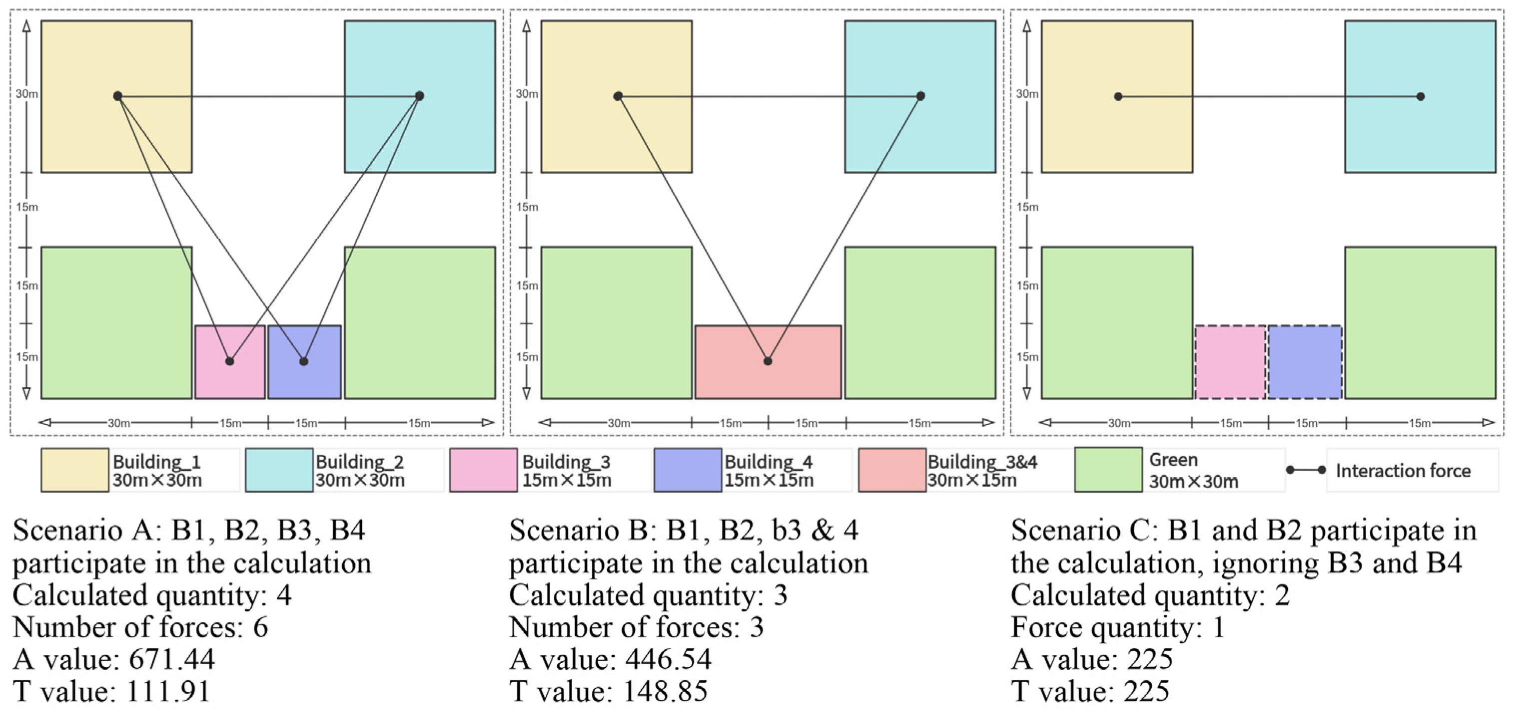
3.2.1. Enhanced 3D Compactness Measurement Model
3.2.2. Multidimensional Comparative Analysis
3.2.3. Driving Mechanism Analysis
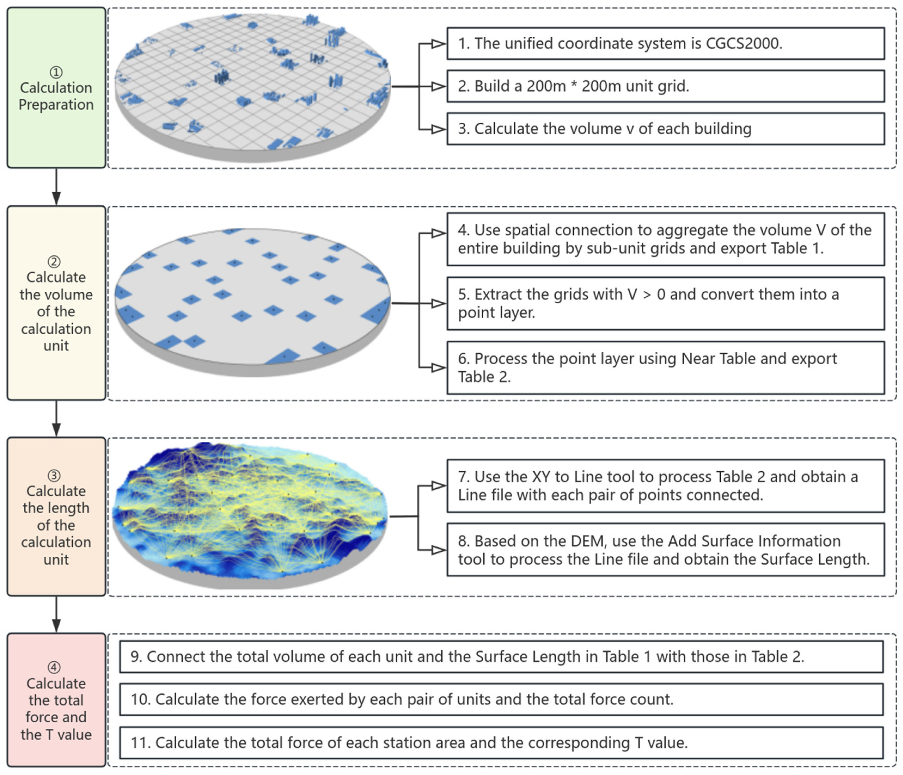
3.3. Research Procedure
3.4. Data Sources and Preprocessing
4. Results
4.1. Spatiotemporal Characteristics of 3D Compactness Evolution
4.1.1. General Growth Trends and Heterogeneity
- (1)
- High-compactness stations (SPB, CQB) exhibited initial values exceeding 60,000, with SPB increasing from 150,211 to 171,955 (14.48% growth) and CQB from 70,908 to 77,971 (9.96% growth). Both demonstrated below-average growth rates, which suggests potential saturation effects in these mature urban nodes;
- (2)
- Medium-high compactness stations (HC, CDD) displayed initial values above 40,000 but showed more dynamic growth trajectories. The compactness of HC increased by 36.74% (43,092→58,925) while that of CDD grew by 46.74% (42,519→62,392), substantially outpacing the mean growth rate. This pattern indicates accelerated development in secondary urban centers during the study period;
- (3)
- The medium-low compactness cohort (YCD, NJB, SN) exhibited initial values between 10,000 and 40,000 but divergent growth patterns. YCD and NJB achieved remarkable expansions that exceeded 100%, whereas SN showed a more modest 15.16% growth. These variations likely reflect differential investment priorities and urban development stages across intermediate stations;
- (4)
- Low-compactness stations (BS, DYD, JYN et al.) demonstrated the most pronounced growth dynamics from sub-10,000 baselines. Most exceeded the average growth rates, with JYN (405.76%), TN (241.40%), and ZYB (225.35%) representing exceptional cases of rapid intensification. Notably, DYD constituted the sole low-compactness station with below-average growth (9.13%), which potentially indicates unique local constraints.
- (5)
- An anomalous case emerged with DZN station, which uniquely exhibited a 5.00% compactness decline (4981→4733). This deviation may reflect either data anomalies or specific redevelopment patterns that require further investigation through case-specific analysis.

| Station Name | T_2015 | T_2025 | ∆T |
|---|---|---|---|
| SPB | 150211 | 171955 | 14.48% |
| BS | 6992 | 11631 | 66.35% |
| YCD | 29358 | 63988 | 117.96% |
| DZN | 4981 | 4733 | −5.00% |
| RCB | 2491 | 3846 | 54.41% |
| LCB | 932 | 1455 | 56.06% |
| NJB | 17262 | 48534 | 181.15% |
| ZZB | 671 | 894 | 33.12% |
| ZYB | 6102 | 19853 | 225.35% |
| JYN | 382 | 1934 | 405.76% |
| CDD | 42519 | 62392 | 46.74% |
| DYD | 4953 | 5406 | 9.13% |
| SN | 15623 | 17992 | 15.16% |
| TN | 970 | 3311 | 241.40% |
| HC | 43092 | 58925 | 36.74% |
| CQB | 70908 | 77971 | 9.96% |
| Average | 34712 | 42491 | 22.41% |
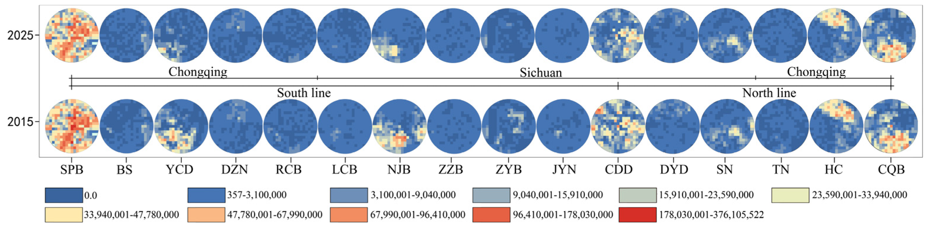
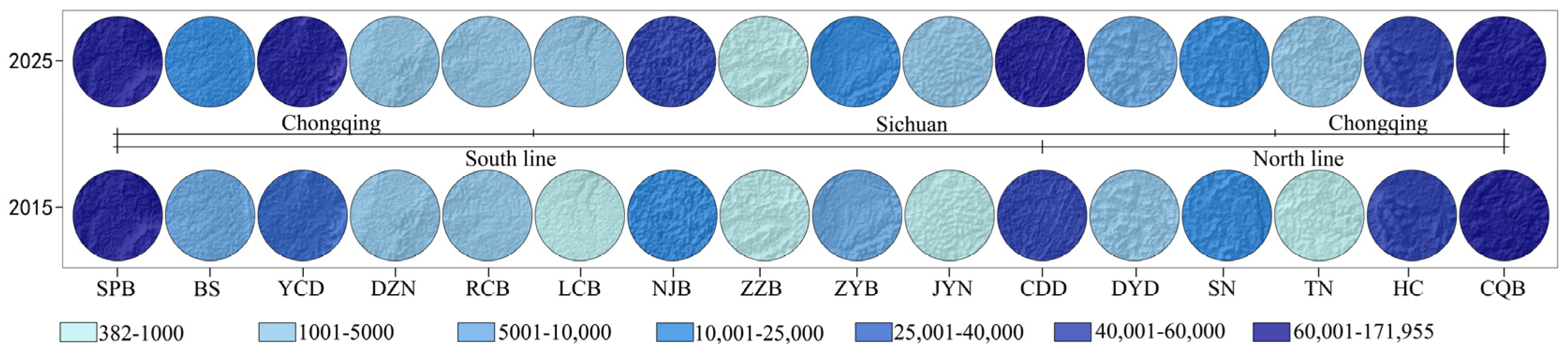
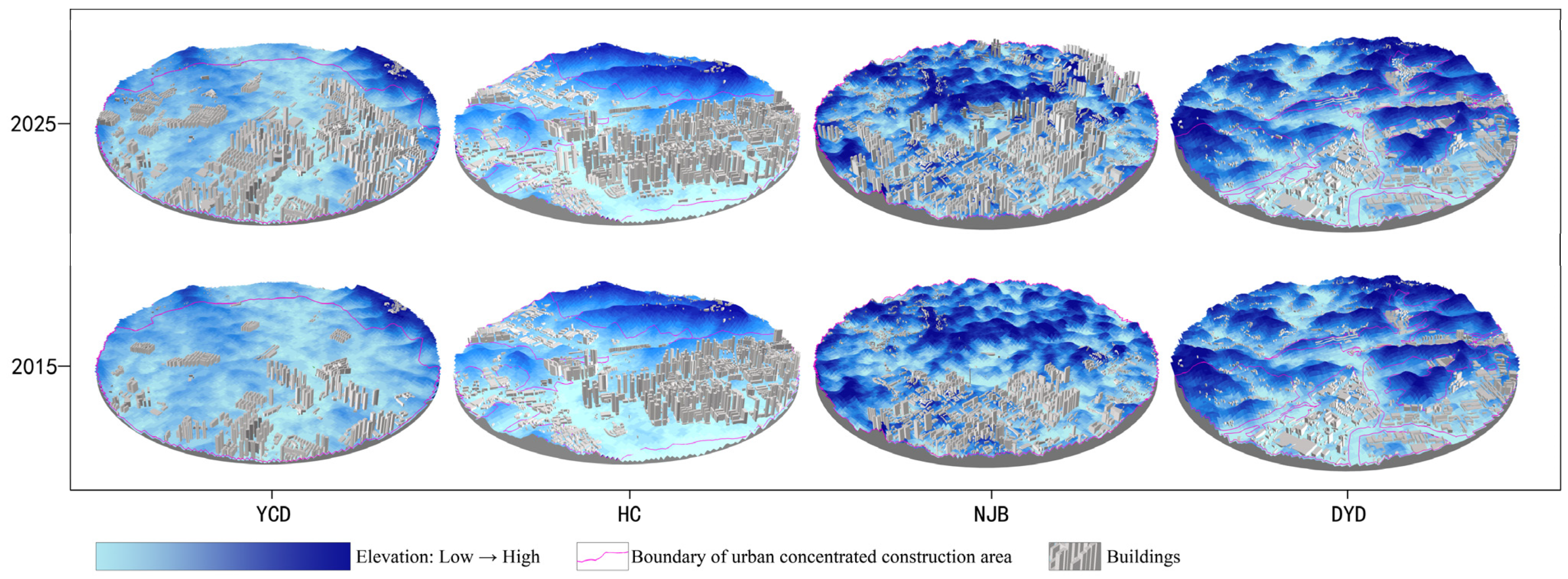
4.1.2. Spatial Pattern Evolution
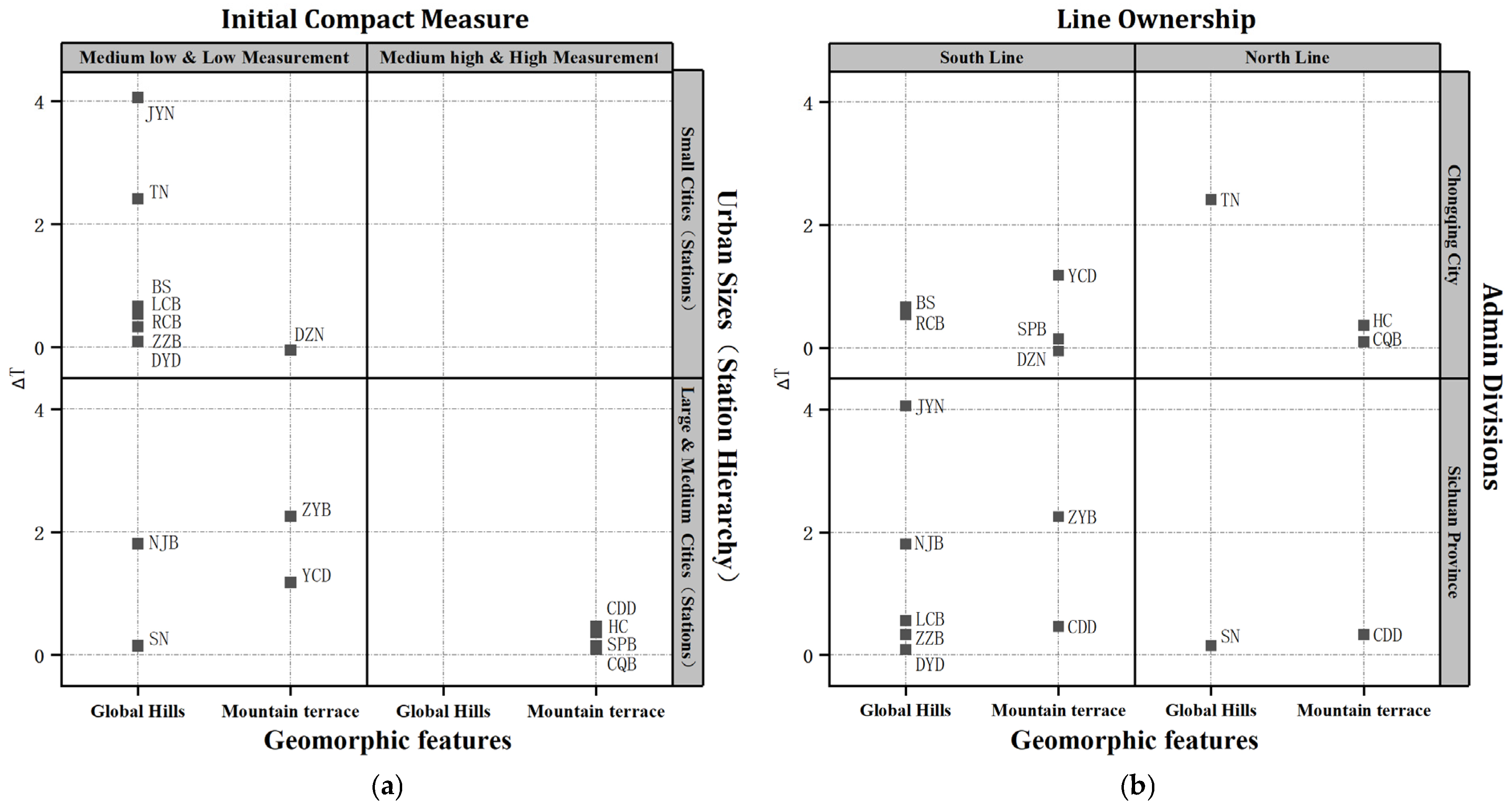
4.2. Evolution Patterns of Compactness Based on Multidimensional Classification
4.2.1. Initial Compactness Perspective
4.2.2. Urban Sizes (Station Hierarchy) Perspective
4.2.3. Geomorphic Features Perspective
4.2.4. Administrative Division Perspective
4.2.5. Line Ownership Perspective
4.3. Driving Mechanism Analysis
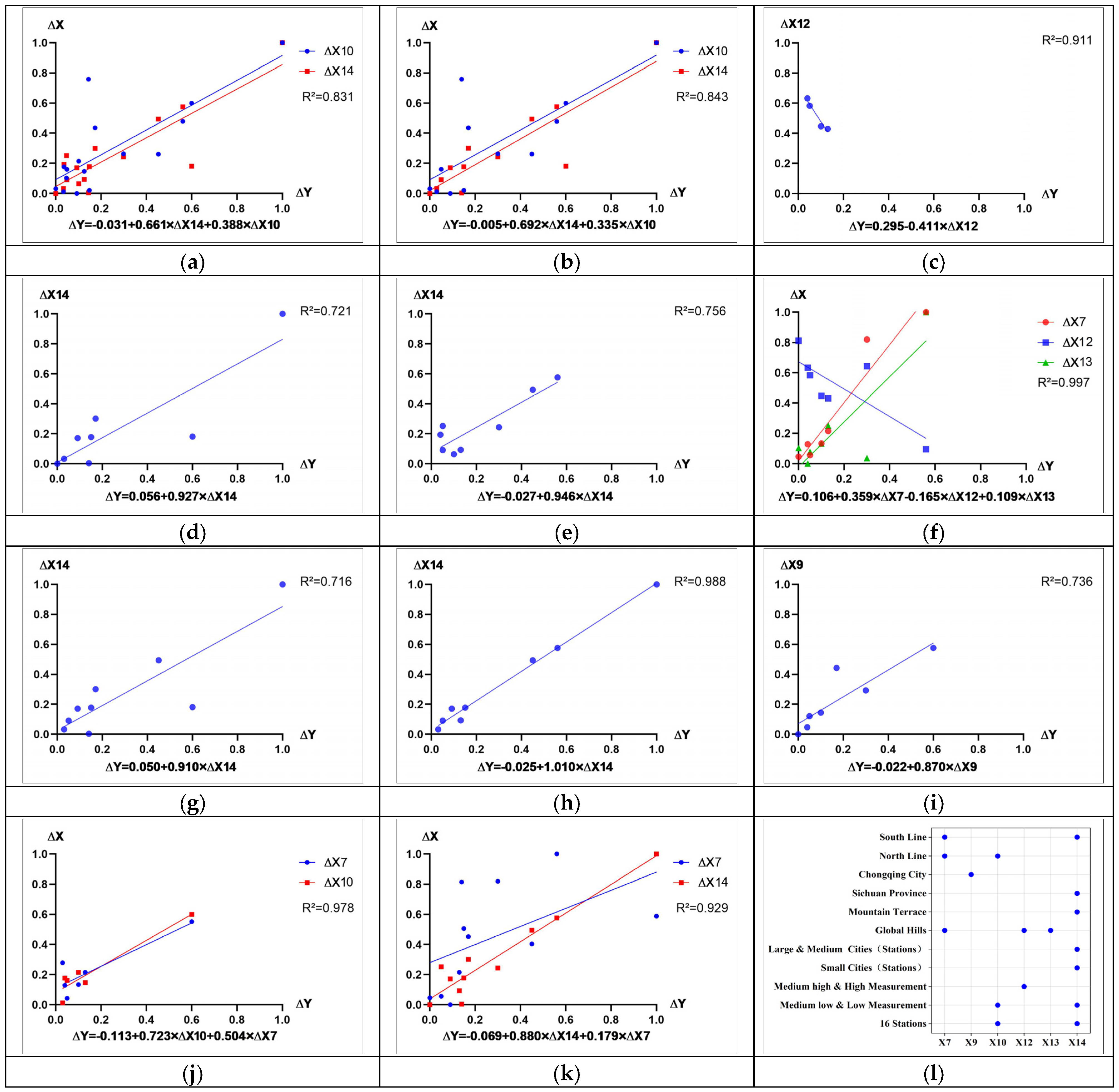
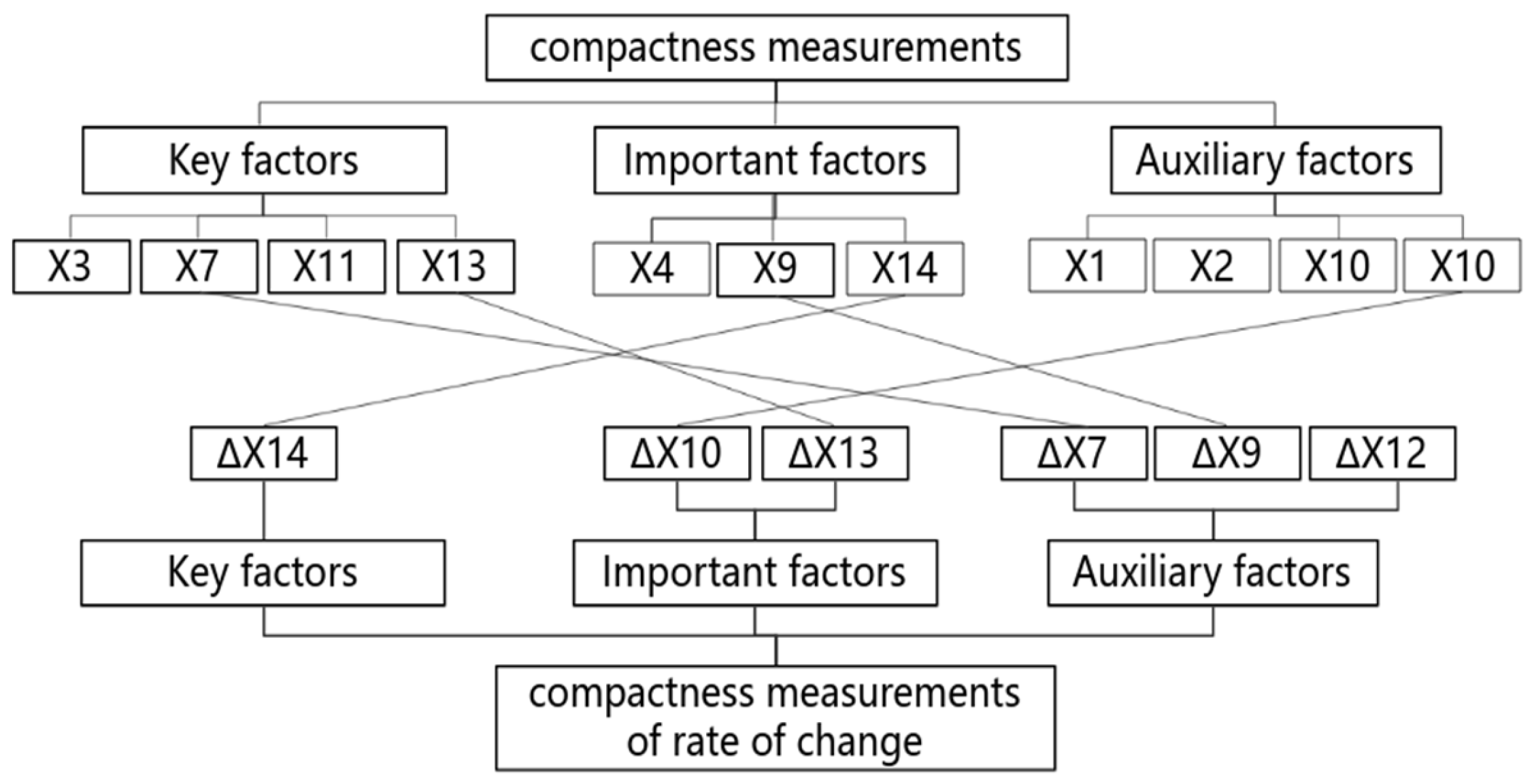
4.3.1. Identification of Compactness Measurement Drivers
4.3.2. Identification of Driving Factors for Compactness Change Rates
4.3.3. Key Driving Factors: Land-Use Scale and Vertical Development
5. Discussion
5.1. Re-Examination of Driving Mechanisms
5.1.1. Spatial Effects of Building Height Diversity
5.1.2. The Dual Effects of Topographic Constraints
5.1.3. Indicator Influence Disparities from an Urban–Rural Integration Perspective
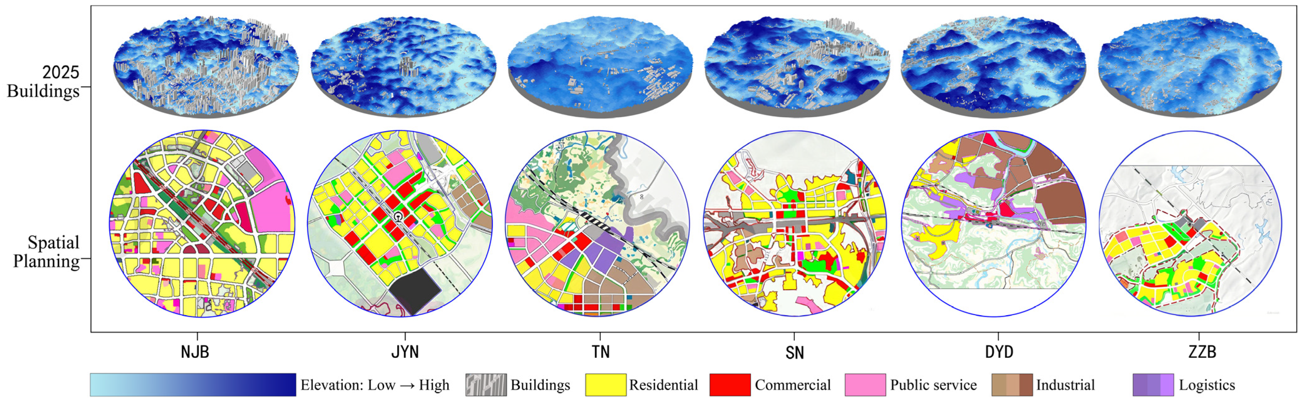
5.2. Planning Strategies for Mountainous High-Speed Rail Station Areas
5.2.1. Morphological Adaptation: Quadruple-Category Management Based on Dual Metrics Integration
5.2.2. Ecological Adaptation: Compactness Ethics Based on “Three-Zone” Coordination
5.2.3. Urban–Rural Integration: Settlement Patterns Based on Core-Periphery Synergy
6. Conclusions
Author Contributions
Funding
Data Availability Statement
Acknowledgments
Conflicts of Interest
References
- Li, M.M.; Verburg, P.H.; van Vliet, J. Global trends and local variations in land take per person. Landsc. Urban Plan. 2022, 218, 104308. [Google Scholar] [CrossRef]
- Ren, C.; Cai, M.; Li, X.W.; Shi, Y.; See, L.D. Developing a rapid method for 3-dimensional urban morphology extraction using open-source data. Sustain. Cities Soc. 2020, 53, 11. [Google Scholar] [CrossRef]
- Guan, X.L.; Wei, H.K.; Lu, S.S.; Dai, Q.; Su, H.J. Assessment on the urbanization strategy in China: Achievements, challenges and reflections. Habitat Int. 2018, 71, 97–109. [Google Scholar] [CrossRef]
- Garmendia, M.; Ribalaygua, C.; Ureña, J.M. High speed rail: Implication for cities. Cities 2012, 29, S26–S31. [Google Scholar] [CrossRef]
- Vickerman, R. High-speed rail and regional development: The case of intermediate stations. J. Transp. Geogr. 2015, 42, 157–165. [Google Scholar] [CrossRef]
- Diao, M.; Zhu, Y.; Zhu, J.R. Intra-city access to inter-city transport nodes: The implications of high-speed-rail station locations for the urban development of Chinese cities. Urban Stud. 2017, 54, 2249–2267. [Google Scholar] [CrossRef]
- Sun, W.; Wang, C.; Liu, C.G.; Wang, L. High-Speed Rail Network Expansion and Its Impact on Regional Economic Sustainability in the Yangtze River Delta, China, 2009–2018. Sustainability 2022, 14, 14. [Google Scholar] [CrossRef]
- Lv, T.; Hu, H.; Han, H.; Zhang, X.; Fan, H.; Yan, K. Towards sustainability: The spatiotemporal patterns and influence mechanism of urban sprawl intensity in the Yangtze River Delta urban agglomeration. Habitat Int. 2024, 148, 103089. [Google Scholar] [CrossRef]
- Zeng, C.; He, J.; He, Q.; Mao, Y.; Yu, B. Assessment of land use pattern and landscape ecological risk in the Chengdu-Chongqing economic circle, Southwestern China. Land 2022, 11, 659. [Google Scholar] [CrossRef]
- He, Y.; Shen, D.; Peng, L.; Xie, C. International Prefabricated Building Seminar on Frontier Technology and Talent Training. In Study on the Three-Dimensional Place Making in the Core Area of Urban Central Railway Station in the Space Narrative Context; Springer: Berlin/Heidelberg, Germany, 2023; pp. 503–513. [Google Scholar]
- Zhang, G.; Zheng, D.; Wu, H.; Wang, J.; Li, S. Assessing the role of high-speed rail in shaping the spatial patterns of urban and rural development: A case of the Middle Reaches of the Yangtze River, China. Sci. Total Environ. 2020, 704, 135399. [Google Scholar] [CrossRef]
- Breheny, M. Urban compaction: Feasible and acceptable? Cities 1997, 14, 209–217. [Google Scholar] [CrossRef]
- Qiu, B. Compactness and Diversity Version 2.0: Two Core Elements of ustainable Urban Development in China. Urban Dev. Stud. 2012, 19, 1–12. [Google Scholar]
- Hu, X.Y.; Yan, H.; Wang, D.; Zhao, Z.Q.; Zhang, G.Q.; Lin, T.; Ye, H. A Promotional Construction Approach for an Urban Three-Dimensional Compactness Model-Law-of-Gravitation-Based. Sustainability 2020, 12, 10. [Google Scholar] [CrossRef]
- Koziatek, O.; Dragicevic, S. A local and regional spatial index for measuring three-dimensional urban compactness growth. Environ. Plan. B Urban Anal. City Sci. 2019, 46, 143–164. [Google Scholar] [CrossRef]
- Yuan, H.; He, Y.; Zhou, J.Z.; Li, Y.; Cui, X.; Shen, Z.W. Research on compactness ratio model of urban underground space and compact development mechanism of rail transit station affected area. Sustain. Cities Soc. 2020, 55, 11. [Google Scholar] [CrossRef]
- Wang, Z.L.; Yuan, H.; Wu, M.H.; Deng, X.; Tang, Y.; Shao, J.Z.; Zeng, Q.H. Urban compactness: Applying a three-dimensional model to strategic region of metro station. Transport. Res. Part D Transport. Environ. 2022, 113, 21. [Google Scholar] [CrossRef]
- Pan, H.X.; Shen, Q.; Zhao, T. Travel and Car Ownership of Residents near New Suburban Metro Stations in Shanghai, China. Transp. Res. Record 2013, 2394, 63–69. [Google Scholar] [CrossRef]
- Rodríguez, D.A.; Kang, C.D. A typology of the built environment around rail stops in the global transit-oriented city of Seoul, Korea. Cities 2020, 100, 12. [Google Scholar] [CrossRef]
- Yan, H.; Wang, K.; Lin, T.; Zhang, G.Q.; Sun, C.G.; Hu, X.Y.; Ye, H. The Challenge of the Urban Compact Form: Three-Dimensional Index Construction and Urban Land Surface Temperature Impacts. Remote Sens. 2021, 13, 23. [Google Scholar] [CrossRef]
- Shirowzhan, S.; Sepasgozar, S.M.E.; Trinder, J. Developing Metrics for Quantifying Buildings’ 3D Compactness and Visualizing Point Cloud Data on a Web-Based App and Dashboard. J. Constr. Eng. Manag. 2021, 147, 14. [Google Scholar] [CrossRef]
- Russell, E.W.; Dantzig, G.B.; Saaty, T.L. Compact City: A Plan for a Liveable Urban Environment. Contemp. Sociol. 1975, 4, 447. [Google Scholar]
- Neuman, M. The compact city fallacy. J. Plan. Educ. Res. 2005, 25, 11–26. [Google Scholar] [CrossRef]
- Gordon, P.; Richardson, H.W. Are Compact Cities a Desirable Planning Goal? J. Am. Plan. Assoc. 1997, 63, 95–106. [Google Scholar] [CrossRef]
- Galster, G.; Hanson, R.; Ratcliffe, M.R.; Wolman, H.; Coleman, S.; Freihage, J. Wrestling Sprawl to the Ground: Defining and measuring an elusive concept. Hous. Policy Debate 2001, 12, 681–717. [Google Scholar] [CrossRef]
- Ewing, R. Is Los Angeles-Style Sprawl Desirable? J. Am. Plan. Assoc. 1997, 63, 107–126. [Google Scholar] [CrossRef]
- Anderson, W.P. Urban Form, Energy and the Environment: A Review of Issues, Evidence and Policy. Urban Stud. 1996, 33, 7–35. [Google Scholar] [CrossRef]
- Li, L.; Huang, X. The Research on Compactness Based on Analyzing the Meaning of “Compact”: Constructing the System of Concepts and lndexes for “Compactness”. Urban Plan. Int. 2012, 27, 33–43. [Google Scholar]
- Yao, Y.; Pan, H.; Cui, X.; Wang, Z. Do compact cities have higher efficiencies of agglomeration economies? A dynamic panel model with compactness indicators. Land Use Policy 2022, 115, 106005. [Google Scholar] [CrossRef]
- Jenks, M.; Burton, E.; Williams, K.; Symes, M. The compact city: A sustainable urban form? Land Use Policy 1997, 14, 215. [Google Scholar]
- Chen, B. Cities, Compact while Ecological. Urban Plan. Forum 2008, 3, 28–31. [Google Scholar]
- Salim, S.; Lakshmi, S.R. Compact city as a tool for Sustainable Urban Development. In Proceedings of the 7th Biennial International Conference on Emerging Trends in Engineering, Science &Technology (ICETEST 2023), Las Vegas, NV, USA, 19–22 October 2023. [Google Scholar]
- Yu, P.H.; Zhang, S.J.; Yung, E.H.K.; Chan, E.H.W.; Luan, B.; Chen, Y.Y. On the urban compactness to ecosystem services in a rapidly urbanising metropolitan area: Highlighting scale effects and spatial non-stationary. Environ. Impact Assess. Rev. 2023, 98, 15. [Google Scholar] [CrossRef]
- Hess, G.R.; Daley, S.S.; Dennison, B.K.; McGuinn, R.P.; Morin, V.Z.; Shelton, W.G.; Lubkin, S.R.; Potter, K.M.; Savage, R.E.; Snow, C.M. Just what is sprawl, anyway? Carol. Plan. J. 2001, 26, 11–26. [Google Scholar]
- Thinh, N.X.; Arlt, G.; Heber, B.; Hennersdorf, J.; Lehmann, I. Evaluation of urban land-use structures with a view to sustainable development. Environ. Impact Assess. Rev. 2002, 22, 475–492. [Google Scholar] [CrossRef]
- Zhao, J.; Song, Y.; Shi, L.; Tang, L. Study on the compactness assessment model of urban spatial form. Acta Ecol. Sin. 2011, 31, 6338–6343. [Google Scholar]
- Schütz, E. Stadtentwicklung durch Hochgeschwindigkeitsverkehr. Konzeptionnelle und methodische Ansätze zum Umgang mit den Raumwirkungen des schienengebundenen Personen-Hochgeschwindigkeitsverkehrs (HGV) als Beitrag zur Lösung von Problemen der Stadtenwicklung. Informationen Zur Raumentwicklung 1998, 6, 369–383. [Google Scholar]
- Gao, Y.N.; Cui, X.; Sun, X.Z. Land Use Characteristics of Commuter Rail Station Areas and Their Impact on Station Ridership: A Case Study of Japan Railways in the Tokyo Metropolitan Area. Land 2024, 13, 23. [Google Scholar] [CrossRef]
- Yang, X.; Yu, Y.; Peng, P.Y.; Liu, C. What affected the vitality of high-speed rail station areas? A case study of Chengdu-Chongqing urban agglomeration, China. Front. Environ. Sci. 2024, 12, 16. [Google Scholar] [CrossRef]
- Cao, Y.; Yu, L.; Li, S. Spatial Evolution of High-Speed Railway Station Areas and Planning response. City Plan. Rev. 2020, 44, 88–96. [Google Scholar]
- Xu, W.; Wang, X. A Study on Characteristics of Spatial Development and Construction ofHigh-Speed Railway Station Areas——An Empirical Analysis Based on theCase of Beijing-Shanghai High-speed Railway Line. Urban Plan. Forum 2016, 1, 72–79. [Google Scholar]
- Liu, Y.S.; Zhou, Y. Territory spatial planning and national governance system in China. Land Use Policy 2021, 102, 9. [Google Scholar] [CrossRef]
- Wang, Z.; He, Y.; He, Y.; Zhou, J.; Yuan, H. On the Three-Dimensional Compactness in A Site-Affected Areaof Urban Railway Central Station in Mountainous Cities of China. Mt. Res. 2020, 38, 740–750. [Google Scholar]
- Central People’s Government of the People’s Republic of China. Notice of The State Council on Adjusting the Standards for Classifying Urban Sizes. 2014. Available online: http://www.gov.cn/zhengce/content/2014-11/20/content_9225.htm (accessed on 20 November 2014).
- Rahman, M.H.; Islam, M.H.; Neema, M.N. GIS-based compactness measurement of urban form at neighborhood scale: The case of Dhaka, Bangladesh. J. Urban Manag. 2022, 11, 6–22. [Google Scholar] [CrossRef]
- Burton, E. Measuring urban compactness in UK towns and cities. Environ. Plan. B Plan. Des. 2002, 29, 219–250. [Google Scholar] [CrossRef]
- Arundel, R.; Ronald, R. The role of urban form in sustainability of community: The case of Amsterdam. Environ. Plan. B Urban Anal. CIty Sci. 2017, 44, 33–53. [Google Scholar] [CrossRef]
- Yang, J.Y.; Shi, B.X. Scale or size? An analysis of the factors that affect building density: Evidence from high-density central urban zones in Asia. Urban Des. Int. 2021, 26, 220–233. [Google Scholar] [CrossRef]
- Xi, C.; Ren, C.; Wang, J.Q.; Feng, Z.B.; Cao, S.J. Impacts of urban-scale building height diversity on urban climates: A case study of Nanjing, China. Energy Build. 2021, 251, 13. [Google Scholar] [CrossRef]
- Shan, P.Y.; Sun, W. Research on 3D urban landscape design and evaluation based on geographic information system. Environ. Earth Sci. 2021, 80, 15. [Google Scholar] [CrossRef]
- Liu, X.B.; Wang, Y.K.; Li, M. How to Identify Future Priority Areas for Urban Development: An Approach of Urban Construction Land Suitability in Ecological Sensitive Areas. Int. J. Environ. Res. Public Health 2021, 18, 21. [Google Scholar] [CrossRef]
- Shi, K.F.; Liu, G.F.; Zhou, L.; Cui, Y.Z.; Liu, S.R.; Wu, Y.Z. Satellite remote sensing data reveal increased slope climbing of urban land expansion worldwide. Landsc. Urban Plan. 2023, 235, 12. [Google Scholar] [CrossRef]
- National Energy Administration and the Ministry for Urbanisation. The Ministry of Housing and Urban-Rural Development and 15 other departments have issued the “Opinions on Strengthening Green and Low-Carbon Construction in County Towns”. Dev. Small Cities Towns 2021, 39, 117–118. [Google Scholar]
- National Development and Reform Commission; Ministry of Natural Resources; Ministry of Housing and Urban-Rural Development; China Railway Corporation. Guiding Opinions on Promoting the Rational Development and Construction of Areas Around High-Speed Railway Stations. Railw. Eng. Technol. Econ. 2018, 33, 46–48. [Google Scholar]
- Zhan, Q.M.; Jia, Y.Q.; Zheng, Z.H.; Zhang, Q.; Luo, L. Associations of land use around rail transit stations with jobs-housing distribution of rail commuters from smart-card data. Geo.-Spat. Inf. Sci. 2023, 26, 346–361. [Google Scholar] [CrossRef]
- Zhang, L.L.; Liu, R.; Zheng, D.Y.; Sun, Y.; Zhao, Z.H.; Dai, J.C. Relationship between Advanced Manufacturing Agglomeration and Regional Economic-Innovative-Social Coupling Coordination Development: A Spatial Analysis in Liangjiang New Area, China. J. Urban Plan. Dev. 2024, 150, 12. [Google Scholar]
- Xia, Z.; Li, C.Y.; Zhang, F.T.; Yan, Y.; Sun, J.; Ma, D.L.; Guo, Z.M. Spatial-temporal heterogeneous analysis of the coupling coordination between new urbanization and urban ecological resilience. Int. J. Urban Sci. 2025, 29, 1–29. [Google Scholar] [CrossRef]
- Luo, L.; Zheng, Z.H.; Luo, J.; Jia, Y.Q.; Zhang, Q.; Wu, C.; Zhang, Y.F.; Sun, J. Spatial Agglomeration of Manufacturing in the Wuhan Metropolitan Area: An Analysis of Sectoral Patterns and Determinants. Sustainability 2020, 12, 23. [Google Scholar] [CrossRef]
- Patru-Stupariu, I.; Stupariu, M.S.; Stoicescu, I.; Peringer, A.; Buttler, A.; Fürst, C. Integrating geo-biodiversity features in the analysis of landscape patterns. Ecol. Indic. 2017, 80, 363–375. [Google Scholar] [CrossRef]
- Chaffin, B.C.; Garmestani, A.S.; Gunderson, L.H.; Benson, M.H.; Angeler, D.G.; Arnold, C.A.; Cosens, B.; Craig, R.K.; Ruhl, J.B.; Allen, C.R. Transformative Environmental Governance. In Annual Review of Environment and Resources, Volume 41; Gadgil, A., Gadgil, T.P., Eds.; Annual Reviews: Palo Alto, CA, USA, 2016; Volume 41, pp. 399–423. [Google Scholar]
- Friedmann, J.; Douglass, M. Agropolitan development: Toward a new strategy for regional planning in Asia. In Growth Pole Strategy and Regional Development Policy: Asian Experience and Alternative Approaches; Elsevier: Amsterdam, The Netherlands, 1978. [Google Scholar]
- Lv, L.; Zhang, S.H.; Zhu, J.; Wang, Z.M.; Wang, Z.; Li, G.Q.; Yang, C. Ecological Restoration Strategies for Mountainous Cities Based on Ecological Security Patterns and Circuit Theory: A Case of Central Urban Areas in Chongqing, China. Int. J. Environ. Res. Public Health 2022, 19, 21. [Google Scholar] [CrossRef]
- Zhang, Z.D.; He, G.; Cai, W.B.; Zhu, Q.; Liu, X.; Ding, F.; Cai, Y.L. Spatial planning constraints will mitigate the fragmentation trajectory of natural and semi-natural landscapes: A case of Lushan City, China. Landsc. Ecol. 2024, 39, 19. [Google Scholar] [CrossRef]
- Yu, K. Ecological security patterns in landscapes and GIS application. Geogr. Inf. Sci. 1995, 1, 88–102. [Google Scholar] [CrossRef]
- Griffiths, G. Land mosaics: The ecology of landscapes and regions. Appl. Geogr. 1998, 18, 98–99. [Google Scholar] [CrossRef]
- Farr, D. Sustainable Urbanism: Urban Design with Nature; John Wiley & Sons: Hoboken, NJ, USA, 2011. [Google Scholar]
- Zhou, Y.E.; Li, L.B.; Zhang, Y.H. Location of transit-oriented development stations based on multimodal network equilibrium: Bi-level programming and paradoxes. Transp. Res. Pt. A-Policy Pract. 2023, 174, 18. [Google Scholar] [CrossRef]
- McGee, T.G. Managing the rural-urban transformation in East Asia in the 21st century. Sustain. Sci. 2008, 3, 155–167. [Google Scholar] [CrossRef]


| Category | Subclass | Quantity | Station Area Name | Classification Criteria |
|---|---|---|---|---|
| Initial compact measure | Medium-low and Low Measurement | 12 | DZN, BS, DYD, JYN, LCB, NJB, RCB, SN, TN, YCD, ZYB, ZZB | Based on the T_2015 distribution characteristics described in Chapter 4.1, with 40,000 as the critical value, values less than 40,000 are classified as medium-low and low; values equal to or greater than 40,000 are classified as medium-high and high. |
| Medium-high and High Measurement | 4 | CDD, CQB, HC, SPB | ||
| Urban Sizes (Station Hierarchy) 1 | Small Cities (Stations) | 8 | BS, DYD, DZN, JYN, LCB, RCB, TN, ZZB | The size of the city is determined according to the “Notice on Adjusting the Classification Standards for Urban Sizes” (Guo Fa [2014] No. 51) [44]; in this study, stations of the third grade and below are classified as small, while the rest are classified as medium or large. |
| Large and Medium Cities (Stations) | 8 | CDD, CQB, HC, NJB, SN, SPB, YCD, ZYB | ||
| Geomorphic features | Global Hills | 7 | CDD, CQB, DZN, HC, SPB, YCD, ZYB | Based on the 3D elevation model and field investigation: flat areas with relatively concentrated, regular, and certain scale features (surrounded by mountains) are called terraces. |
| Mountain Terrace | 9 | BS, DYD, JYN, LCB, NJB, RCB, SN, TN, ZZB | ||
| Admin Divisions | Sichuan Province | 8 | BS, CQB, DZN, HC, RCB, SPB, TN, YCD | Administrative divisions of Chongqing City and Chengdu, Suining, Ziyang, and Neijiang cities in Sichuan Province. |
| Chongqing City | 8 | CDD, DYD, JYN, LCB, NJB, SN, ZYB, ZZB | ||
| Line ownership | North Line | 11 | BS, CDD, DZN JYN, LCB, NJB, RCB, SPB, YCD, ZYB, ZZB | Chengdu-Chongqing High-Speed Railway (South Line), Chengdu-Suining-Chongqing Railway (North Line)—Baidu Encyclopedia. |
| South Line | 6 | CDD, CQB, DYD, HC, SN, TN |
| Variable | Index | Code | |
|---|---|---|---|
| Dependent Variable | 3D Compactness Index | Y | |
| Compactness Change Rate | ∆Y | ||
| Independent Variable | Centralized Construction Zone Planning Proportion | X1 | Planning |
| Relative Distance from the Station to the City Center | X2 | ||
| Planned Floor Area Ratio | X3/∆X3 | ||
| Elevation Standard Deviation | X4 | Terrain | |
| Terrain Undulation Range | X5 | ||
| Mean Slope Gradient | X6 | ||
| Built-up Land Area | X7/∆X7 | Land use | |
| Land Patch Density | X8/∆X8 | ||
| Largest Patch Index | X9/∆X9 | ||
| Aggregation Index of Land Patches | X10/∆X10 | ||
| Building Footprint Area | X11/∆X11 | Building | |
| Building Density | X12/∆X12 | ||
| Mean Building Height | X13/∆X13 | ||
| Standard Deviation of Building Heights | X14/∆X14 |
| Data Types | Sources | Time | Type | Purpose |
|---|---|---|---|---|
| 3D Building Data | Amap API, ArcGIS Online, Field surveys | 2015, 2025 | Vector &1 m grid | Construction of 3D models |
| Built-up Land Data | ArcGIS Online, Field surveys | 2015, 2025 | 1 m grid | Calculation of building land indicators |
| DEM | Geospatial Data Cloud (GDC) | —— | 30 m grid | Calculation of elevation, slope, and undulation |
| Spatial Planning | Websites of district (county) people’s governments in various places | 2021 | picture | Definition of centralized construction areas |
| Ancillary Data | Tianditu and s-FARM, Amap Street View panoramic | 2015, 2025 | Grid & picture | Auxiliary identification of construction land, building outlines and heights |
| Major Categories | Subcategory | T_2015_ave | T_2025_ave | ∆T_ave |
|---|---|---|---|---|
| Initial Compact Measure | Medium Low and Low Measurement | 7263 | 15310 | 110.81% |
| Medium High and High Measurement | 83635 | 99545 | 19.02% | |
| Physical geography | Small Cities or Stations | 2531 | 3472 | 37.18% |
| Large and Medium-sized Cities or Stations | 59863 | 75010 | 25.30% | |
| Admin Divisions | Global Hills | 6257 | 11816 | 88.84% |
| Mountain Terrace | 68136 | 78458 | 15.15% | |
| Line ownership | Sichuan Province | 13178 | 21530 | 63.38% |
| Chongqing City | 60018 | 68917 | 14.83% | |
| City size (Site level) | North Line | 32675 | 42552 | 30.23% |
| South Line | 37116 | 45013 | 21.28% |
| Type | Characteristics | Measures |
|---|---|---|
| Type I: SPB CDD | High Compactness—High Development Intensity: (1) Development is relatively saturated, with commercial and business functions in the core station area being well-developed. (2) Few or no vacant plots remain in areas distant. (3) Some low-efficiency spaces exist, such as urban villages, wholesale markets, and aging residential areas. | Functional replacement and three-dimensional renewal: Enhancing urban land-use efficiency through functional replacement optimizes the urban form of aging, low-efficiency areas and facilitates industrial upgrading [55]. (1) Strengthen coordination with major urban transportation corridors to amplify the catalytic effect of transit on precinct regeneration; (2) Holistically regulate building plot ratios and height controls to optimize three-dimensional urban morphology through functional replacement; (3) Prioritize spatial efficiency by employing vertical development to enhance urban compactness; (4) Preserve landmark structures while strategically shaping skylines to reinforce spatial identity. |
| Type II: CQB NJB CYD HC | High Compactness—Medium Development Intensity: (1) A certain amount of vacant land remains undeveloped. (2) The overall building quality within the station area is relatively new. (3) The spatial layout has been largely established. (4) Building density is low, but the average building height is notably high. | Gradient regulation and functional mix: Implementing building height gradients balances development intensity with livability, fostering integrated industrial, social, and innovation ecosystems [56]. Future infill development should adopt context-sensitive strategies: (1) Maintain high-density development near station cores through transit-oriented design, intensifying commercial functions with varied building heights to create urban landmarks; (2) Implement transitional intensity and height reductions in peripheral zones, optimizing residential functions with lower density, moderated heights, and enhanced greening for improved environmental quality; (3) For vacant parcels, create three-dimensional streetscapes integrating terrain features with lifestyle needs, developing integrated high-speed rail-living-industry communities. |
| Type III: DYD DZN | Low Compactness—Medium Development Intensity: (1) A certain amount of vacant land remains undeveloped. (2) The station area is predominantly occupied by industrial buildings, exhibiting homogeneous land-use types. (3) Building heights are uniform, and the overall floor area ratio is low. | Land-Use Transition and Base floor-area-ratio Control: Urban ecological resilience necessitates diversified land uses beyond monofunctional development [57], adopting job-housing balance and transit-integrated concepts: (1) Coordinate interregional construction land quotas and total building volumes during territorial spatial planning; (2) Direct infill development toward residential and supporting functions to intensify land use; (3) Convert inefficient industrial land to commercial uses [58], enriching street facades and architectural height diversity; (4) Enforce minimum industrial plot ratios while avoiding uniform height restrictions. |
| Type IV: JYN TN BS RCB LCB SN ZYB ZZB | Low Compactness—Low Development Intensity: (1) Ample vacant land is available for future construction. (2) Abundant natural landscapes and distinct topographic features are present. (3) Some existing construction provides a foundational development base. | Ecological Conservation and Patch Agglomeration: Dual emphasis on ecological protection and compact development safeguards natural resources while optimizing built environments: (1) Conduct micro-scale analysis of terrain variation to identify critical ecological features, extending macro-level ecological networks [59]; (2) Integrate new development parcels with existing built patches for clustered, compact layouts; (3) Explore the characteristic resources of the city and Leverage high-speed rail passenger flows to develop distinctive station area identities;Harvesting the unique resources of the city; (4) Promote intensive land use through diversified building heights and development intensities in new projects. |
Disclaimer/Publisher’s Note: The statements, opinions and data contained in all publications are solely those of the individual author(s) and contributor(s) and not of MDPI and/or the editor(s). MDPI and/or the editor(s) disclaim responsibility for any injury to people or property resulting from any ideas, methods, instructions or products referred to in the content. |
© 2025 by the authors. Licensee MDPI, Basel, Switzerland. This article is an open access article distributed under the terms and conditions of the Creative Commons Attribution (CC BY) license (https://creativecommons.org/licenses/by/4.0/).
Share and Cite
Gui, T.; Yuan, H.; Liu, Z. Spatiotemporal Evolution of 3D Spatial Compactness in High-Speed Railway Station Areas: A Case Study of Chengdu-Chongqing North–South Line Stations (2015–2025). Land 2025, 14, 1275. https://doi.org/10.3390/land14061275
Gui T, Yuan H, Liu Z. Spatiotemporal Evolution of 3D Spatial Compactness in High-Speed Railway Station Areas: A Case Study of Chengdu-Chongqing North–South Line Stations (2015–2025). Land. 2025; 14(6):1275. https://doi.org/10.3390/land14061275
Chicago/Turabian StyleGui, Tijin, Hong Yuan, and Ziyi Liu. 2025. "Spatiotemporal Evolution of 3D Spatial Compactness in High-Speed Railway Station Areas: A Case Study of Chengdu-Chongqing North–South Line Stations (2015–2025)" Land 14, no. 6: 1275. https://doi.org/10.3390/land14061275
APA StyleGui, T., Yuan, H., & Liu, Z. (2025). Spatiotemporal Evolution of 3D Spatial Compactness in High-Speed Railway Station Areas: A Case Study of Chengdu-Chongqing North–South Line Stations (2015–2025). Land, 14(6), 1275. https://doi.org/10.3390/land14061275