Article

An Italian Renaissance Garden Through the Centuries: A Methodology for Its Study, Evaluation and Valorisation

Centro de Investigación en Arquitectura, Patrimonio y Gestión para el Desarrollo Sostenible (PEGASO), Universitat Politècnica de València, 46022 Valencia, Spain
*
Author to whom correspondence should be addressed.
Land 2025, 14(5), 970; https://doi.org/10.3390/land14050970
Submission received: 16 March 2025 / Revised: 25 April 2025 / Accepted: 28 April 2025 / Published: 30 April 2025

Abstract

:
The villa of the Veneto is a complex that includes the manor house, the agricultural buildings, as well as the green spaces of the garden, the orchard and the fields. The research presented in this article focuses on the case of Villa Giusti-Puttini at Santa Maria in Stelle (Verona, Italy), with the aim of unravelling the history and state of conservation of the villa’s park, which has never been studied before. The research has been carried out by interconnecting the historical archival documentation (written documents and maps) with the current state, always considering the possible interpretations suggested by the specialised related bibliography. The result has been the identification of the elements of permanence and transformation of the territory and landscape of the villa. Elements such as its boundaries, interior paths, vegetation and watercourses make it possible to outline guidelines aimed at recovering the memory of this historic landscape which has been largely preserved over the centuries, and which constitutes one of the most significant heritage aspects of this area of Italy. In addition to providing in-depth knowledge of a specific object, this research can serve as an example for the study of other cultural landscapes.

1. Introduction

1.1. A Brief Introduction to the Villas of the Veneto as a Territorial Phenomenon

The phenomenon of the villas of the Veneto corresponds to a political and territorial control plan articulated by the government of the Venetian Republic, called La Serenissima. This strategy of conquering the territory of Terraferma (mainland) began in the mid-14th century [1] and intensified after several historical events that undermined its commercial power: the conquest of Constantinople by the Turks (1453), the discovery of America that diverted commercial interests away from Venice and the defeat inflicted on Venice by the League of Cambrai in 1509. Following these events, Venice decided to strengthen its presence in the hinterland by trying to encourage Venetian noble families to invest in the purchase of land in the hinterland. Therefore, Venice undertook important works for the reclamation of land, the provision of communications and water management through the institution of the Provveditori sopra i beni inculti in 1545 [2,3]. Water had always represented a fundamental element of defence, trade and communication for the Republic of Venice, and its control had always been at the centre of the La Serenissima’s policies [4]. Thus, Venetian noble families and local families already settled in the hinterland began to colonise and cultivate the territory, while Venice was cleaning up its funds thanks to the growing agricultural economy [5]. The importance that Venice attached to the control of the territory is evident from the cartographic work of its territory, which began as early as the 16th century and which materialised in an unprecedented set of detailed maps [2,6].
At the same time, in line with the classical values of humanist culture, it dignified agriculture and the families of the hinterland who were engaged in it. In this way, towards the end of the 16th century, villeggiatura became an opportunity for noble Venetian families to display their economic power [7,8,9]. It was also a chance for local families to acquire the noble titles that enabled them to establish family and commercial relations with the capital. The villas became places of social relations, representation, festivities and opulent banquets, a phenomenon that reached unprecedented levels of development in the second half of the 17th century and in the 18th century, both in Italy and in Europe. However, in areas more distant from Venice, a different development was observed in the villas belonging to local families, which maintained a strong productive vocation, recalling the humanistic ideal of the country house as a “locus amoenus”, a refuge in nature and a meeting point for the cultural and literary circles of the time [10]. This is the case in the province of Verona, where the villas are characterised by this double facet of agricultural production and a place of leisure and rest [5]. The garden of the 14th and 15th century was a pleasant, bucolic place, sheltered from the noise of the city, an occasion for literary reflection, a landscape that changed with the seasons and favoured conversation between writers and poets [11].
In the context of the Veneto, following the classical tradition [4], the term villa is used to identify the whole of a property that includes the owner’s manor, the surrounding land, the buildings, as well as the people who worked and lived there, as already described. From the earliest examples in the 15th century, the productive character of the Veneto villa was manifested in the close link between the manor house and the agricultural structures connected to it. The first villas that emerged in the 15th century in Veneto were not designed by famous architects but were rather modest complexes that found their raison d’être in the interaction between agricultural functions and the lord’s manor. The first representation of a villa understood in this way is found in the treatise “De Agricoltura” by Pietro Crescenzi, written in the 14th century and published only at the end of the 15th century [12,13,14].
Some of these villas were born as transformations of towers and fortified elements linked to the control of the territory [15]. Others were the result of new settlements as a consequence of the agrarian transformations of the time. In any case, the villas are an encounter between “frugal life” and “holy agriculture” which, with their crops, water courses, paths and vegetation, determine the landscape of the Veneto region and its most original and characteristic cultural heritage [16], with a continuous structure marked by the geometry of vineyards towards the hills and by the cultivated fields on the plain that remains substantially intact until the 19th century [17]. Within this territorial structure, the villas are mostly located on the plain and the lower part of the hills. The core of the villas is the manor and agricultural buildings built around courtyards surrounded by gardens often defined by a wall separating them from the rest of the countryside. These spaces, in the 15th and 16th centuries, usually included leisure spots (pergolas, fountains, gardens) and elements linked to the survival of the family (orchards and fruit trees), and later in time, larger-scale green architecture (topiary, labyrinths, grottoes, flowerbeds, etc.) [16].

1.2. Villa Giusti-Puttini: Case Study of Its Context

The village of Santa Maria in Stelle, located in the Valpantena, just a few kilometres from Verona (Italy), is known for its hypogeum from Roman times (dated between the 1st and 3rd century AD) and early Christian times, built to protect a natural spring that gushed out in the place where the village church now stands. In early Christian times, the hypogeum was used as the first baptismal font [18]. From the mid-15th century onwards and in relation to the transformation of the territory and its management, five villas were settled in Santa Maria in Stelle and the nearby hamlet called Vendri, representing a clear and relevant example for understanding the transformations that occurred in villa architecture in the mainland territories and in the province of Verona within the phenomenon of occupation and management of the territory developed by the Republic of Venice [1,11,12,19].
From the 14th century onwards, the term villa comprised the complex comprising the count’s residence or manor house, the adjacent land (fields, orchard, park and garden), the buildings that stood there (the manor house, sharecroppers‘ and farm labourers’ houses, pigeon tower, haystacks, barns, icehouses, ponds, chapels, pergolas, mills, cisterns and aviaries) and the men who worked and lived there (the lord, the foreman, labourers, peasants and servants, with their respective families). It was a complex with a predominantly productive character, with rather modest architecture that accommodated both agricultural functions and the lord’s country residence. The first description of a villa complex appears in the treatise De Agricoltura by Pietro Crescenzi, written in the 14th century and published only at the end of the 15th century [11,12,14]. The best-known episode of the villas of Veneto and that had more repercussions in other countries is undoubtedly due to the villas built by Palladio during the 16th century, but it is a territorial phenomenon that precedes the architect of Vicenza and transcends his time reaching the nineteenth century.
The five villas built around Santa María in Stelle and Vendri belonged to the same branch of the Giusti di San Quirico family, later Giusti delle Stelle, one of the most important families in Verona from the 15th century onwards. Among them, Villa Giusti-Puttini is the first to be established in the location, before the first half of the 15th century, and the one that best preserves the traces of the transformations carried out over the centuries [20]. The manor house, with its time-layered rooms, frescoes and polychrome ceilings, is currently listed with the highest level of protection and has been the subject of several studies focusing on the history of the Giusti delle Stelle family [21,22,23], the manor and its architecture [20,22,24,25,26,27] and the frescoes that decorate its interiors [24,28].
However, to date, no one has studied the villa as a territory, with the buildings, but also with the courts, the garden and the brolo (term used in northern Italy to identify an orchard or, by extension, a garden or wooded place generally enclosed between boundary walls), its relationship with the environment and the water management system. The elements of the landscape, despite the transformations, have been maintained over time and bear witness to the organisation of the agricultural territory. The research presented in this text focuses on the study of the history and configuration of this small portion of territory that represents the villa.

2. Materials and Methods

The previous studies carried out by the authors on Villa Giusti-Puttini had focused mainly on the manor house, its architecture and its architectural values [20,22,25]. These studies had focused on the history of the Giusti family, the phenomenon of the villas in the Veneto and the pre-Palladian villas [29], the cultural and historical environment of the Villa Giusti-Puttini complex [22], as well as on the direct study of the manor house in all its architectural, structural, functional, decorative aspects, etc. [20,25]. In these previous studies carried out by the authors, a very detailed survey of the manor, a study of the materials, construction techniques and material and structural lesions was carried out by means of mapping and cataloguing sheets of construction details [25]. In this new phase of the research, the study of the historical garden and the whole of the park of Villa Giusti-Puttini and its relationship with the rest of the villas of the Giusti family in the towns of Santa Maria in Stelle and Vendri is addressed. This territorial and landscape dimension had not been dug into by any researcher to date. In order to contextualise the subject and case study, a literature review has been carried out, through the consultation of the physical and online catalogues of specialised libraries (Biblioteca Civica and Biblioteca d’arte of the Museo di Castelvecchio in Verona; Fondazione Querini Stampalia, Università Iuav, Biblioteca Marciana in Venice) and online repositories such as Internet Archive, Google Scholar, etc. This literature review has contributed to each of the different aspects related to this research: on the villa as a territorial phenomenon [5,7,12,13,29,30,31] and in the context of the province of Verona, the Valpantena and the village of Santa Maria in Stelle [15,23,24,32,33]. On the other hand, a bibliographical study has been carried out focusing on the Veronese territory [17,31], the historical gardens [34,35,36,37], the landscape of the Venetian villas and the Veronese territory [4,11,38,39,40] and its conservation [41,42,43,44,45]. These texts have been fundamental to understand the landscape and territory of the Veneto villas and to extract the parameters that have allowed us to develop an analysis of the case study. The concepts of territory and landscape are assumed in the meaning proposed by Turri [17], whereby the territory is the physical space where human beings and the community live, work, cultivate and produce, while the landscape is the visible materialisation of the actions in the territory. For the conservation and revitalisation of historic gardens, official documents [45] as well as specific literature [43,44,46,47] and case studies have been consulted to provide a wide range of examples of studies and approaches [46,48,49,50].
The research is carried out by means of a methodology that allows us to cross-reference information from bibliographical sources with the abundant archival documents and with the direct study of the villa and its park. (Figure 1). For the study of the documentary sources [46,51], first of all, a compilation was made of all the documents cited in previous studies and publications related to the villa in question, the other villas of the Giusti family in Santa Maria in Stelle and the Giusti family itself. This search led to the identification of the archives in which the documentation was kept, which were consulted directly, extracting the information necessary for this study. Secondly, a study was carried out through archives, libraries and public administration services: the Archivio di Stato di Venezia (A.S.Ve.), the Archivio di Stato di Verona (A.S.Vr.), the Biblioteca del Seminario Vescovile di Padova (B.S.V.PD.), the digital archive of the Comune di Verona and some digital archives such as that of the Charles University in Prague. In the Archivio di Stato di Venezia (A.S.Ve.) and the Archivio di Stato di Verona (A.S.Vr.), documents related to property deeds, wills, descriptions and maps related to disputes between owners related to water management, maps related to land divisions and cadastral maps were consulted. A total of fifteen written documents and eight historical maps were consulted in these archives (see Appendix A), from which high-resolution digital reproductions were obtained, allowing a high level of enlargement. The written documents make it possible to identify the owners and the ownership passages, to know the disputes over the management of water, which allow us to understand the importance of this element in the management of the villas, and to gather brief descriptions of the villas and palaces located in Santa Maria in Stelle. The letter written by Pietro Donato Avogaro to “Benedicto Lacioso Canonico mantuano” (B.S.V.PD., doc. 1652, 647.I) is kept in the Library of the Seminario Vescovile di Padova (B.S.V.PD.) (see Appendix A). It is a long document of 23 handwritten pages dating from around 1495 [21] that describes the villa, the manor and the park in detail. This document, already transcribed in 1988 by Ferrarin [21] and partly translated by the authors of this text, allows us to understand the cultural atmosphere of the villa. At the same time, some parts of the palace and the garden can be related to the present situation, although both the transformations and the possible literary descriptions make it difficult to develop a confident and accurate interpretation.
In the digital archive of the Municipality of Verona, some historical maps are available for consultation (Austrian cadastre, 1844–1890; Italian cadastre, 1896 and subsequent updates; EIRA maps of 1971 and 1997) while others are preserved in the State Archives of Venice (Napoleonic cadastre, 1817) or digitised in the Digital Archive of the Charles University in Prague. The comparative study of historical maps [46,48,51] from the 15th century to the present day has provided an enormous amount of data, the results of which will be explained in the corresponding section of this article (see Section 3.2). These maps have been drawn over time with different objectives, so it must be understood that the differences may not only be linked to the transformations carried out on the site but also to the objectives of the draftsman. The permanence of the elements in more than one consecutive map has been considered as a guarantee of their existence, while the presence of an element in a single map has been considered as a possibility of existence but with precautions. In some of the maps, there is a scale that allows the plans to be compared with each other, and the historical plans with the current situation. For the study of the current situation of the villa, the updated cadastral map was available. In addition, the historical aerial photographs available in Google Earth from 1980 in the area, up to the most updated version, have been used. The comparative analysis of the aerial photographs has made it possible to verify the permanence of the architectural and vegetal elements, as well as to identify the traces of the historical landscape. The lack of funds to date has not allowed the use of tools to carry out a specific survey (GIS or LiDAR) which could represent an advance in the study of the site in the future. Due to funding limitations, it has not been possible to carry out a study of the plant species present in the park to date, a study which could provide new data.
The study of the written documents has provided descriptions of the villa and the park (see Section 3.3), which have been fundamental to support the representations on the historical maps. On the other hand, the direct study carried out in situ has provided the material data on the current state of the villa. The comparison between the historical data and the current state has made it possible, on the one hand, to corroborate the veracity of the historical information and, on the other hand, to verify the permanence of the elements of the villa’s landscape up to the present day and to identify the traces of the elements that have partly disappeared.
Therefore, the methodology (Figure 1) consisted in constantly cross-referencing three sources of data: 1. historical documents (family historical documents, historical maps and cadatres and the letter written by Avogaro); 2. the specialised bibliography on the cultural and historical context, the Renaissance gardens, the villas of the Veneto and the landscape and the territory, especially of the Veneto; 3. data on the villa at present, at the level of the architecture, the park and the elements and traces in the site. The cross-referencing of the stratified data has made it possible to extract information on the cultural elements (cultural environment, owners and their environment) and landscape elements (built architecture, plant architecture, water courses, accesses, axes and views, connections and paths, cultivations and uses). From this analysis, the level of conservation and transformation and the consequent guidelines for the enhancement of this historic cultural landscape are extracted.

3. Results

3.1. Villa Giusti-Puttini and Its Territory

The Valpantena is an alluvial valley that connects the city of Verona with the Lessini Mountains. According to some, its name, Valpantena, derives from the presence of the Pantheon located in Santa Maria in Stelle since Roman times; according to others, its name is of Etruscan origin [24]. Regardless of the etymology of its name, this valley has always been an important element in the territory of connection between the city and the mountains and its human occupation has been proven since the Palaeolithic age [52]. The villages of Santa Maria in Stelle and Vendri, located in the southern part of the Valpantena a few kilometres from the city of Verona, were most probably inhabited in Roman times when the hypogeum was built to collect and canalise water to an existing villa in the area or for the use of the local population [53]. The survival of these settlements over time is reflected in maps from the 15th century onwards, such as the Almagià map [54], as well as in all subsequent maps (Figure 2). The proximity of these settlements, the presence of the water that comes down from the mountain, the sweet hill environment and the fertility of the land were perhaps the factors that consolidated this area so that some important families of Verona had already established their properties and their place of rest and villeggiatura here from the 15th century onwards.
Santa Maria in Stelle and Vendri constitute a unique territorial ensemble due to the presence of five villas built between the 14th century and the 17th century (Figure 3): Villa Giusti-Puttini, probably built as early as the end of the 14th century, is an example of a pre-Palladian villa and then transformed in the following centuries; the palace of Zenovello Giusti, built at the end of the 16th century and demolished in 1675, was a luxurious Venetian-style palace with a tripartite plan; the Corte ai Casai is a rural courtyard remodelled by the family as a manor house after the destruction of the palace; Villa Giusti-Bianchini, with a wide portico built in the second half of the 16th century, was never finished; and Villa Giusti-Melloni, the only one located in the very close hamlet of Vendri, was probably built in the second half of the 16th century with a clear Palladian character. These five villas created a territorial system related to agriculture, water and the agricultural management of a noble family’s possessions between the 16th and 17th centuries.

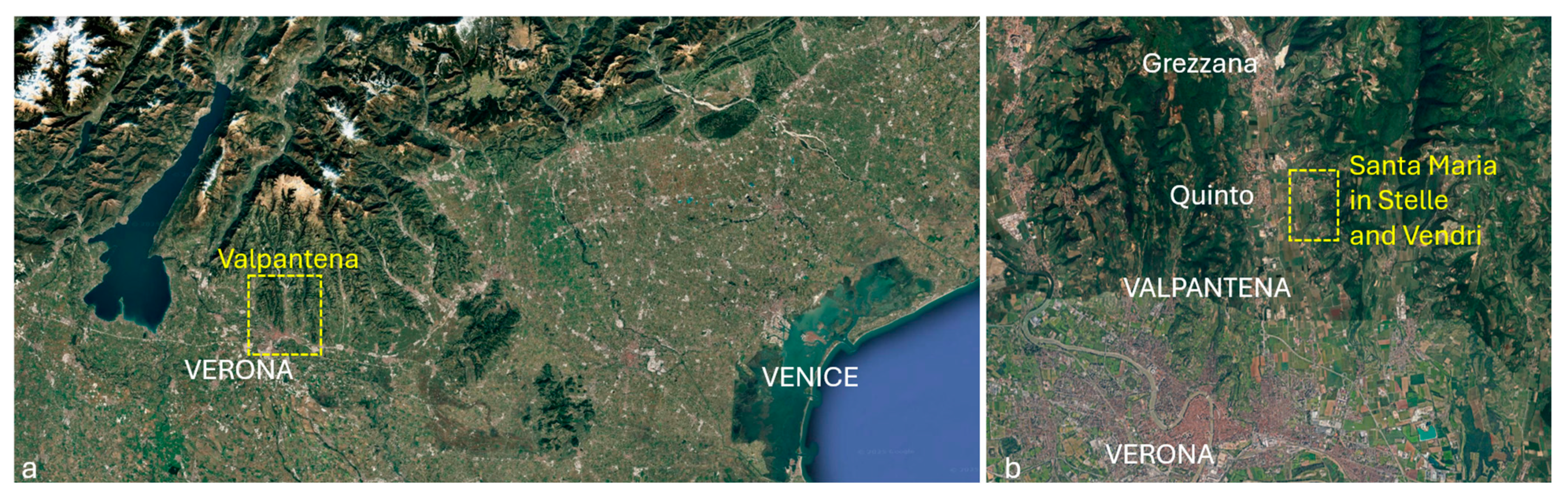
3.2. Territory and Landscape of Villa Giusti-Puttini Through Historical Maps

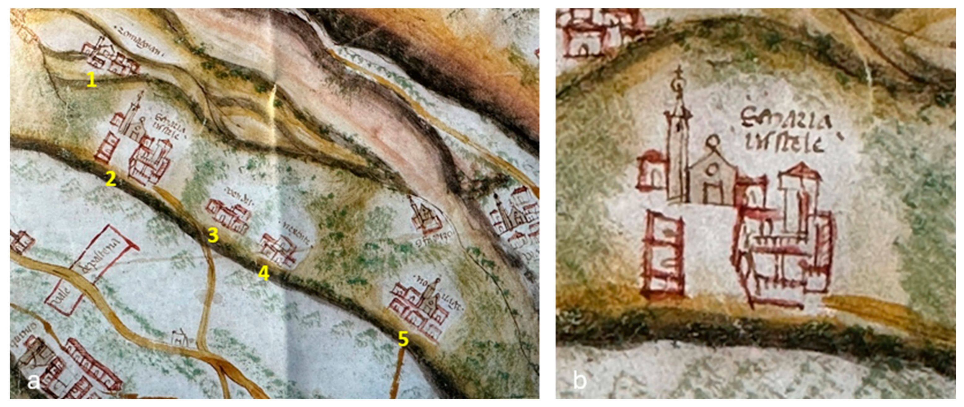
The first known representation of Villa Giusti-Puttini to date is probably the one drawn in the village of Santa Maria in Stelle in the Carta dell’Almagià (Figure 4a), a map dated around 1460 [33]. It is a sketchy representation that, despite its inaccuracy, gives us relevant information about the villa and the landscape. One must bear in mind that, especially in the case of the residential buildings, it is a conventional representation that probably mainly represents the size and importance of the settlement [33]. In the detail of the village of Santa Maria in Stelle (
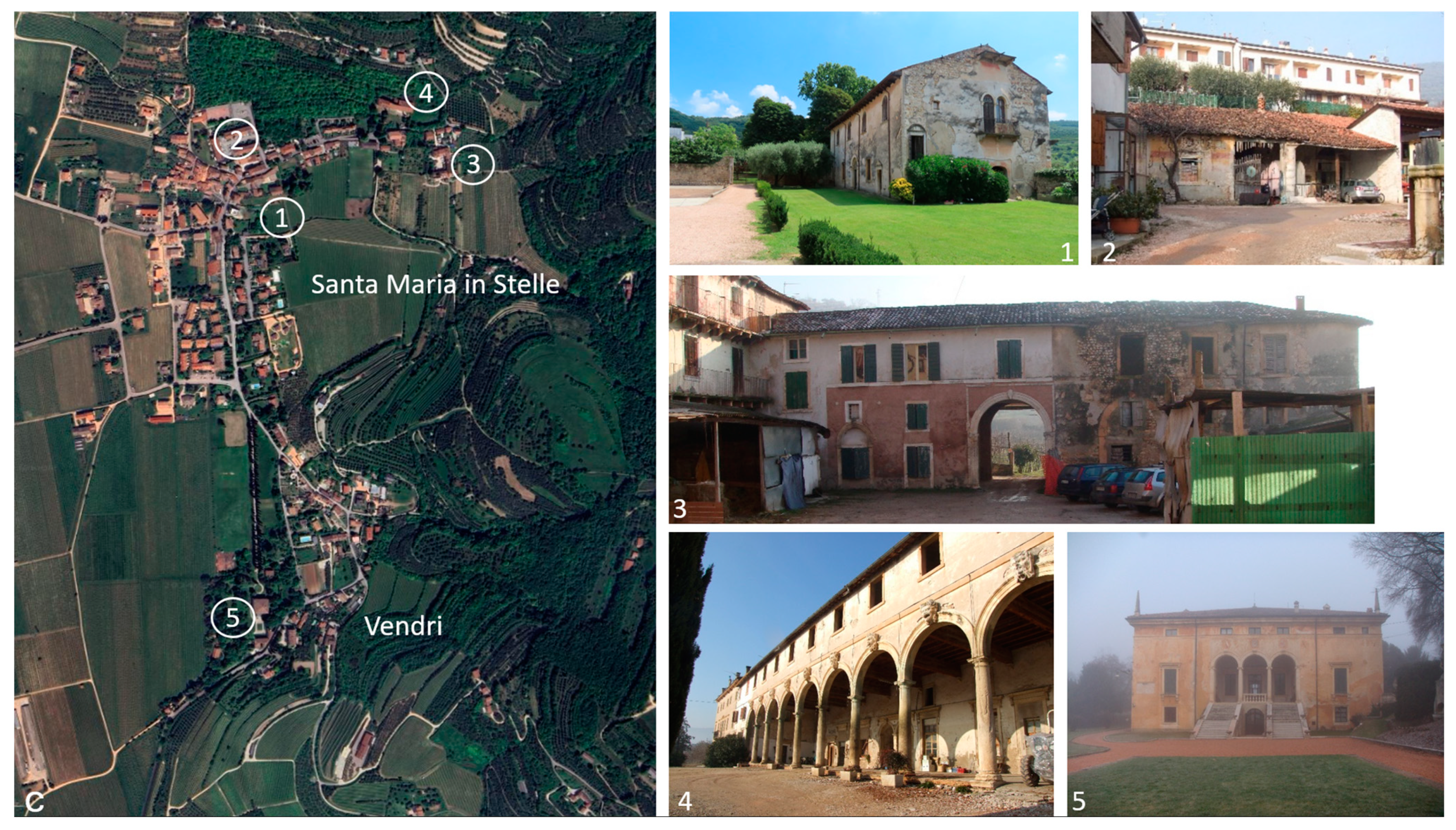
Figure 4b), a number of elements can be clearly distinguished: the church at the end of the main road, the residential buildings flanking the road; a building that appears to be covered with a dome that could symbolise the hypogeum or a chapel to the left of the church and to the right of the main road, a large complex with a pigeon tower and two courtyards.
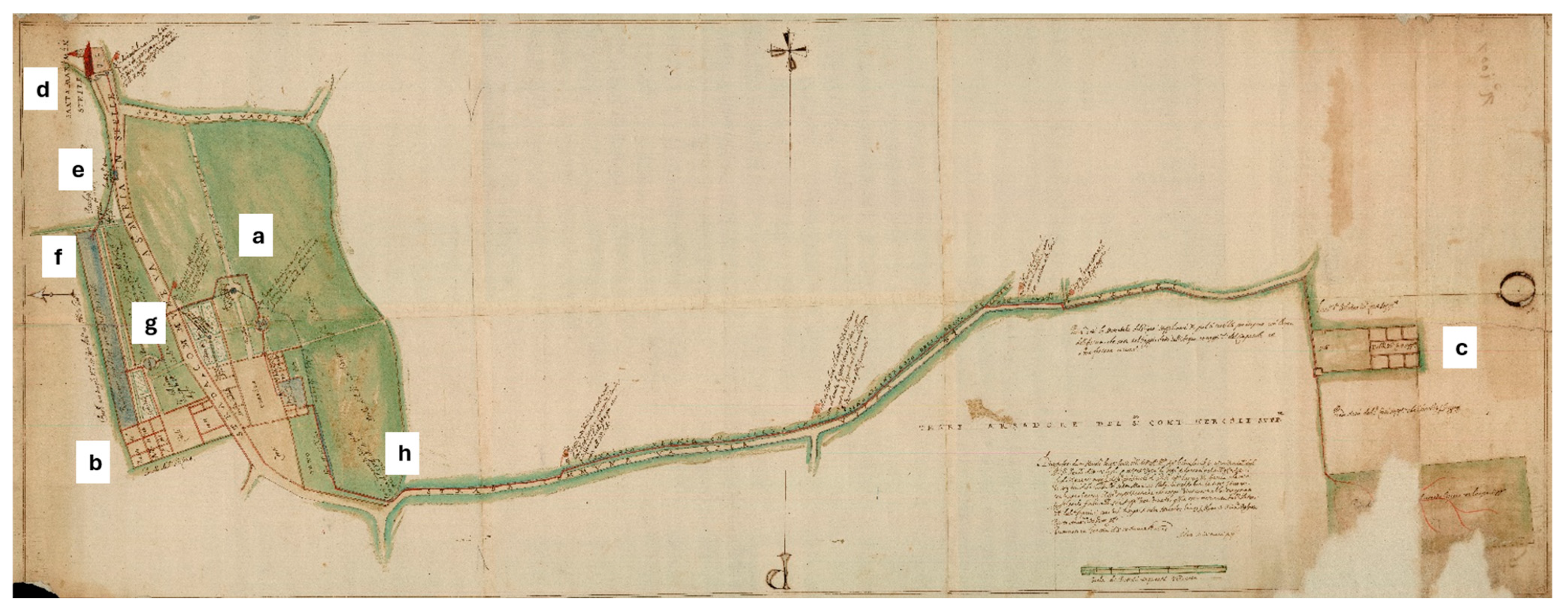
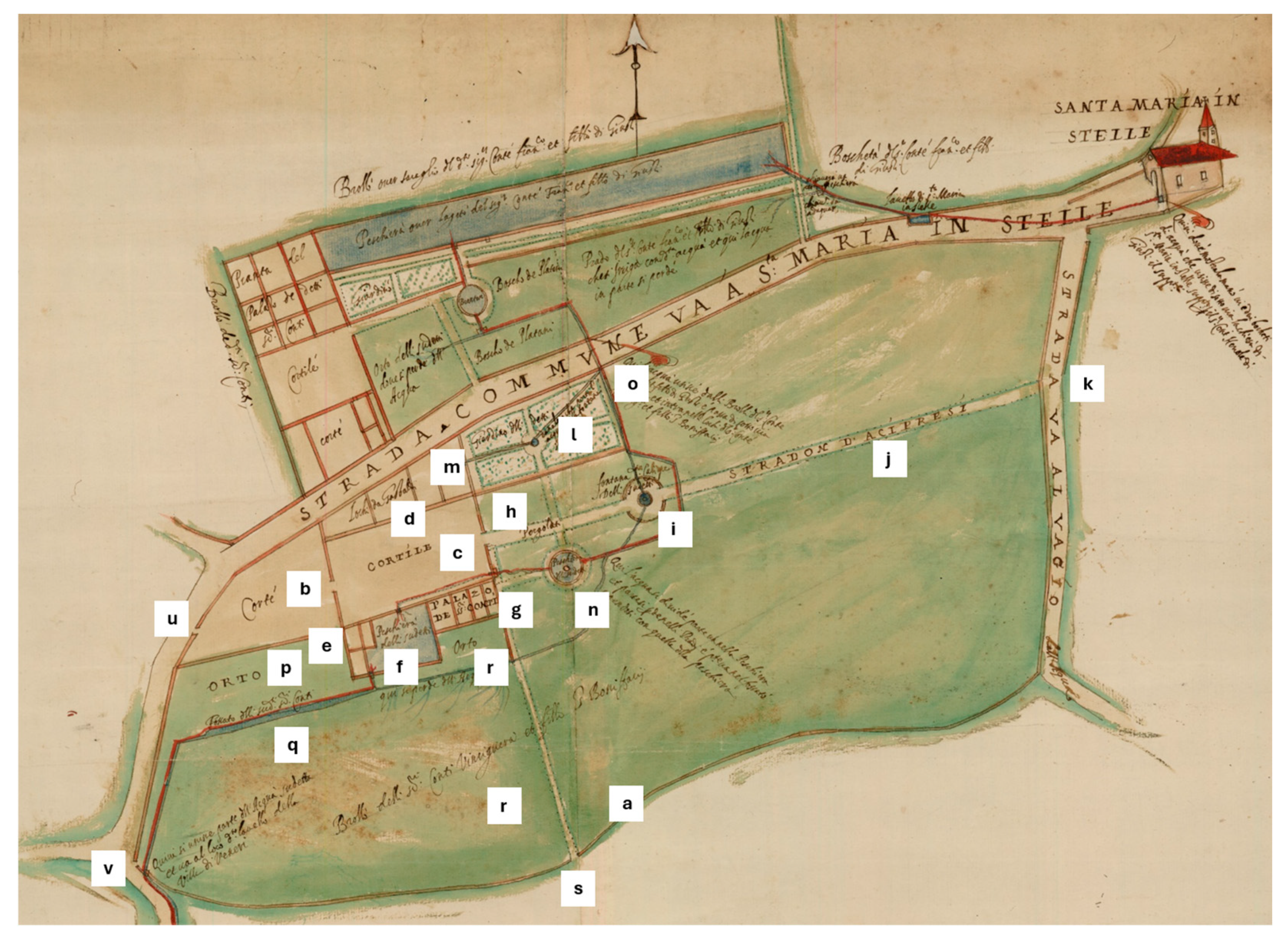
The first map in which a direct reference to the villa appears dates back to 1598 (A.S.VR. Campagna Archive—B.13, no. 155), even though the drawing centres on the Vendri property, currently Villa Giusti-Melloni. Much more detail is provided by Ercole Peretti’s drawing of 1625 (A.S.VE. Beni Inculti—Verona, rot. 74, deck 64, dis. 5) which refers to the property inherited by Vinciguerra San Bonifacio in 1622. The drawing (Figure 5), representing Villa Giusti-Puttini (a), the palace of Zenovello (b) in Santa Maria in Stelle and Villa Giusti-Melloni in Vendri (c), was made to define the correct management of water between the three properties. The complaint lodged by Count Ercole Giusti, owner of the villa in Vendri (c), concerned the water that, coming from under the church of Santa Maria delle Stelle (d), was to irrigate his property passing through the properties both of Count Francesco and his son Giusti (b-f-g) and Count Vinciguerra and his son Sanbonifacio (a). The path of water through the three properties is quite complex. It starts from under the church, passes through the wash house of Santa Maria in Stelle (e), enters the fishpond of Francesco Giusti (f), passes through his garden, the spring and the grove of plane trees (g) and then passes under the road and enters the property of Vinciguerra di Sambonifacio (a) to irrigate the garden and the brolo, bringing water to the fountain. Then it divides between the canalisation that irrigated the brolo directly and the one that entered a first fishpond and a second fishpond to then join the moat behind the manor house and finally exit in the south-eastern corner from the property (h) to skirt the road towards Vendri and the property of Ercole Giusti (c).
The detail with which the map was drawn allows us to know the essential parts and elements of the properties that the water crossed. The drawing (Figure 6) shows the boundary wall and the walls of the buildings in the plan, as well as details of all the garden elements, the vegetable gardens, the brolo, etc. It is a drawing made to scale in “pertiche veronesi” (2.057489 m) and in fact, if one compares the proportions of the map elements with those of the buildings that are still present, it has a good degree of reliability. In this sense, it seems sensible to take it into account as a faithful representation of the villa in 1625.
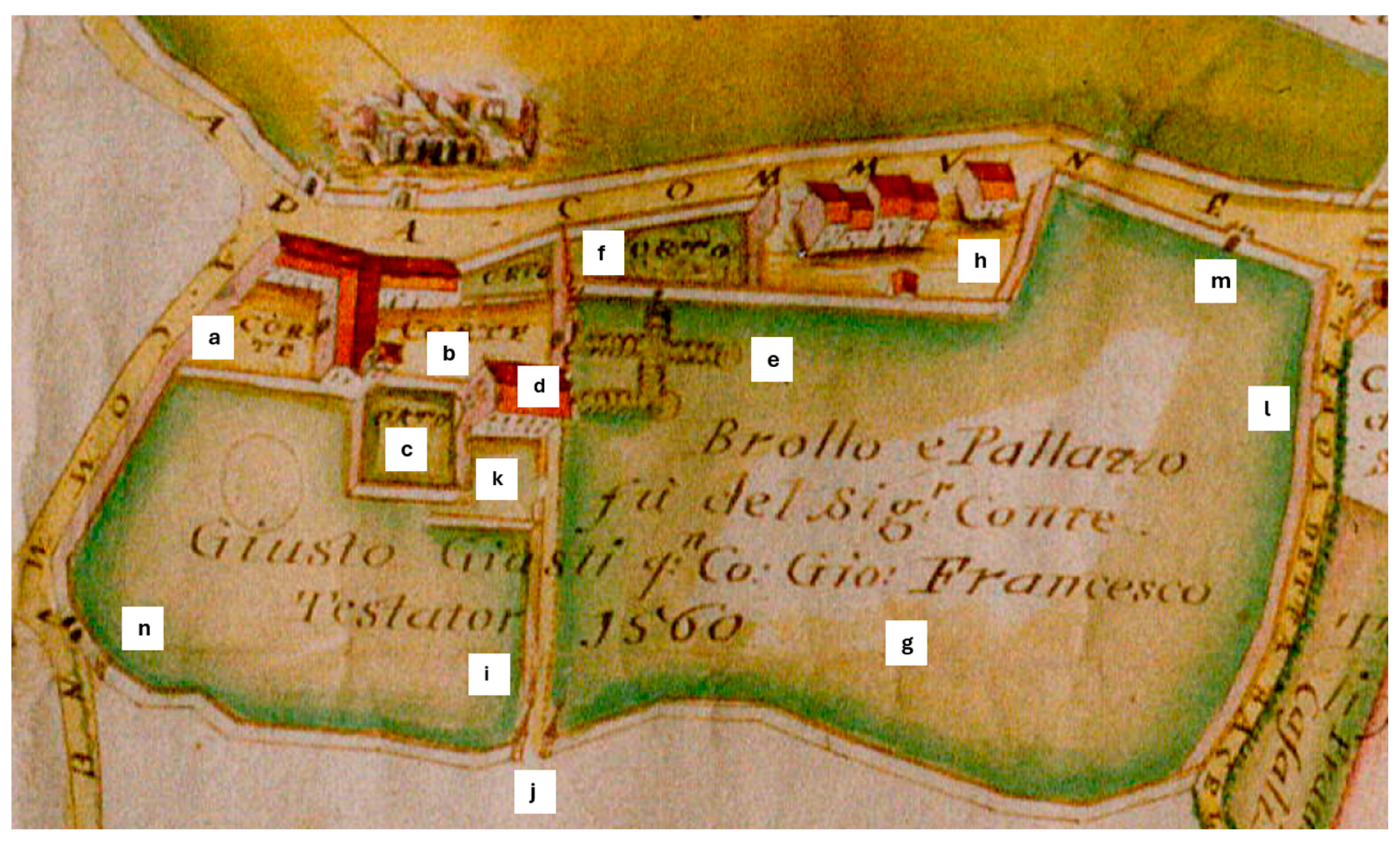
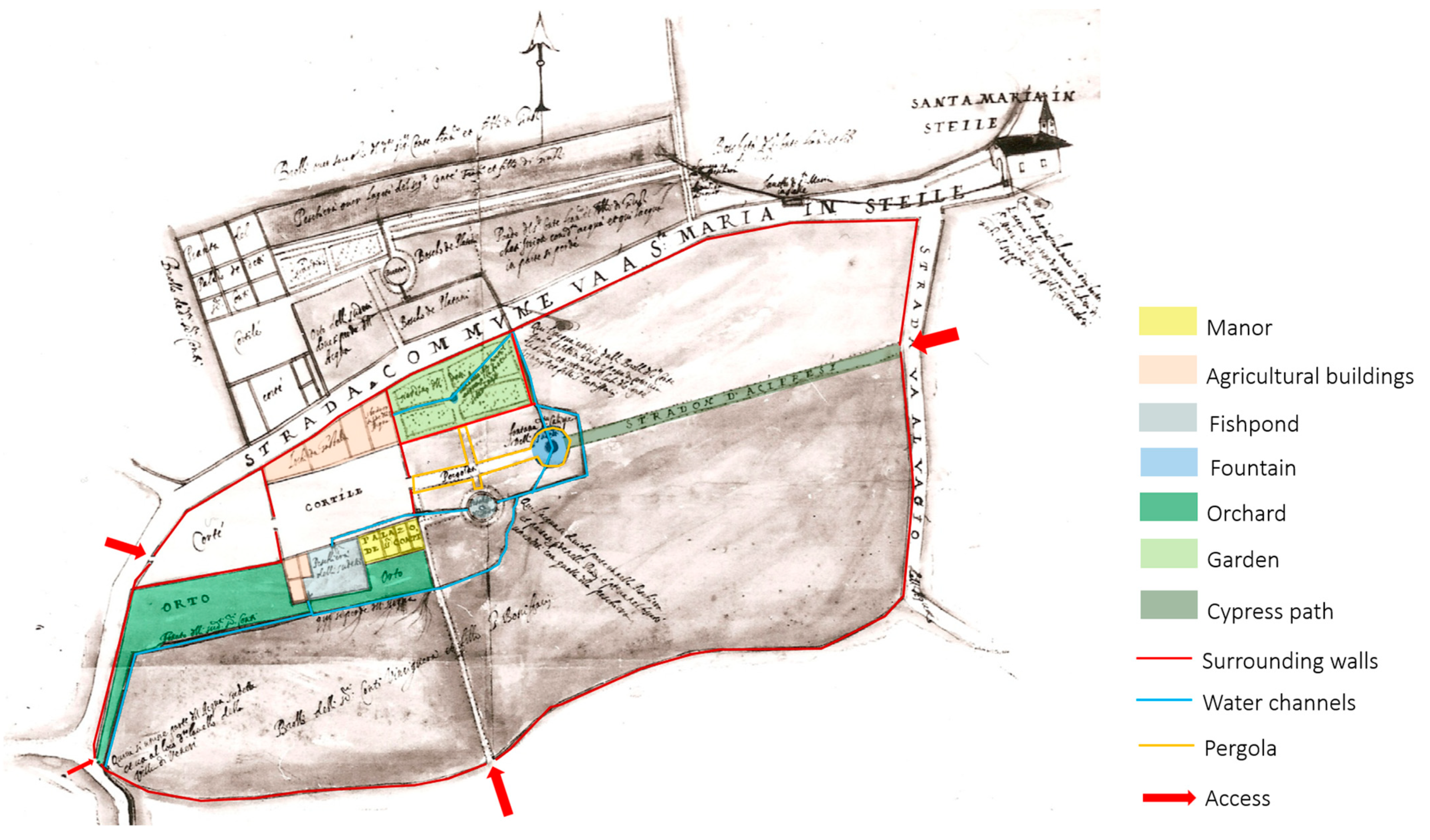
The villa is bounded by a boundary wall (a) separating it from the surrounding fields and consists of the following elements from left to right: the first courtyard (b) accessed from the road through an opening on the west side; the second courtyard (c) flanked, to the west and east, by two boundary walls both with a central opening, to the north, by constructions called “Lochi da Gastaldi” (foreman building) (d), to the south, by constructions without denomination (e), the fishpond (f) and the manor of the counts (g); and to the east of the courtyard, an opening gives access to a path called “pergola” (h) leading to the fountain where the name of the muse of the poem “Caliope” seems to be read (i). The path then continues in the “stradone d’acipressi” (cypress avenue) (j) to an opening in the “strada va al vagio dell’acqua” (k). In the northern part of the path named “pergola” (h), there is a garden (l) with a central fountain or basin, four large flowerbeds, a gutter named “underground” and a connection of the basin or fountain to the building named “Lochi da Gastaldi” (d) where there is a water slope (m) on the eastern wall towards the garden. To the south of the path is a circular fishpond (n) that functions as a circulation element for the water entering the property from the north (o) and follows towards the large rectangular fishpond (f). In the southern part of the courtyard and manor house are two orchards (p) separated by a moat (q) from the brolo (r). This map also shows the access paths to the villa on the south (s), east (k) and west (u) sides and a possible small access in the south-east corner (v). In this drawing, the water path is very detailed and has a main route which enters the property from the municipal road to the north (o), circles around the fountain (i), enters the circular fishpond (n), enters the courtyard (c), the rectangular fishpond (f) and the moat (q) and exits the property in the south-western corner and then continues to the hamlet of Vendri. Several paths branch off from this main route, which serve to irrigate and beautify the property: the garden (l), the fountain (i), and the brolo (r).
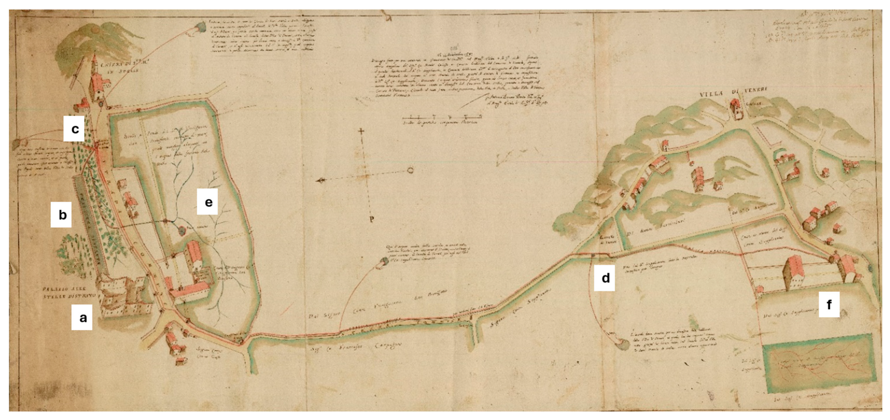
This planimetric drawing was followed by several axonometric drawings depicting the complex, which give the measure of the transformations the villa has undergone over more than two centuries. In the map drawn by Antonio Benoni in 1683 (A.S.VE. Beni Inculti—Verona, rot. 102, deck 86, dis. 5) (Figure 7) some significant differences from the map of 1625 (Figure 5) appear. Firstly, this document records the destruction of the Palazzo di Zenovello in 1675 (a) and the large fishpond annexed to the palace (b). It is possible that the destruction of the palace led to a change in the circulation of water. In the map of 1625, the water that came out of the hypogeum spring under the church of Santa Maria in Stelle apparently passed through the public wash house to enter the garden of the Zenovello palace and finally into the villa of Vinciguerra Sanbonifacio. On the contrary, in the map of 1683 (Figure 7) there appears to be a direct circulation between the public wash house of Santa Maria in Stelle (c) and that of Vendri (d). The diatribe consists in the claim of Count Nicolò Giusti, owner of the villa in Vendri (f), to ensure that the water flowing from the spring of Santa Maria in Stelle reaches Vendri without intermediate interruptions.
The detail of the present Villa Giusti-Puttini (Figure 8) shows us some important differences from the layout mapped in the 1625 drawing (Figure 6). Firstly, a portion of the land in the northern area of the property appears to be cut out and surrounded by a new boundary wall and the construction of three new buildings, possibly residential or rustic (a). Secondly, where in 1625 there was only a dividing wall between the courtyard and the access courtyard, in 1683, a transversal building is drawn that occupies the entire size of the courtyard and, with a subway, provides access to the manor courtyard (b). Thirdly, with respect to the elements of the park, the garden with the flowerbeds disappears, being occupied by the construction of the new buildings to the north (a); the enclosure of the access court towards the brolo disappears (c); the large quadrangular fishpond that was located to the west of the manor appears as “ruined fishpond now orchard” (d); the circular fishpond to the east of the manor appears as “dry hole” (e); and the water canals change their layout—those that fed the garden and the western fishpond disappearing, and those that fed the orchard and the brolo becoming much simpler. Although the representation of the buildings may not be correct, given that the purpose of the map was water management, some details can be detected that may have some veracity: the quadrangular fishpond retains a boundary wall (d), adjacent to the fishpond appears a small tower that could be the present pigeon tower (f), and the manor appears to have access from the west side (g). Access to the property from the main road to the west (h) and from the road behind to the east (i) is preserved.
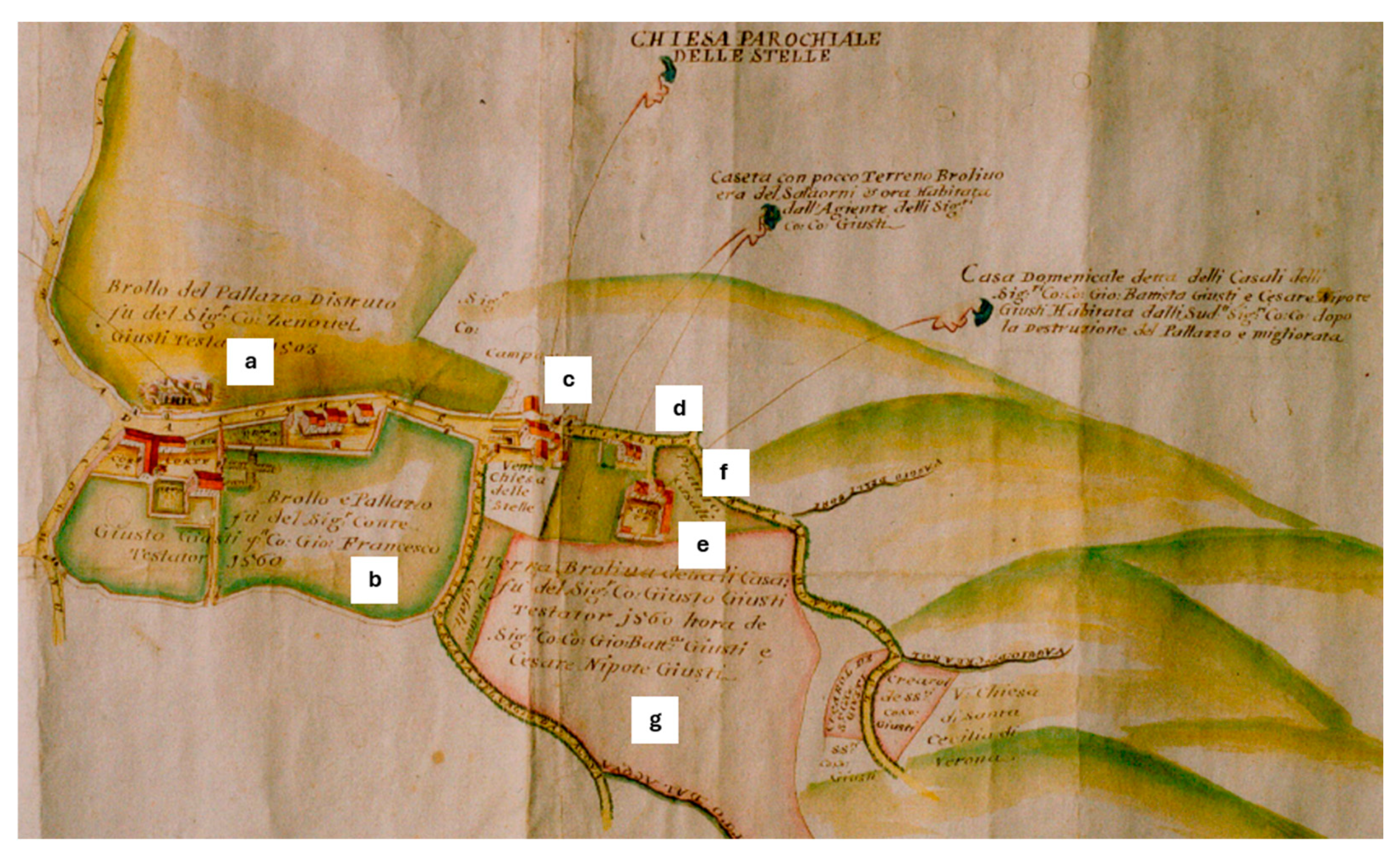
The following graphic document dates back to 1735 and is the drawing by Francesco Cornale, an engineer of the city of Verona and public surveyor (A.S.VR, Campagna Archive—B. 13, no. 154) with the aim of defining the boundaries of the properties of Count Giovan Battista Giusti and his nephew Cesare Giusti (Figure 9). The fact that the purpose of the map is different from the previous ones is evident in the area drawn as well as in the lack of attention to water courses and canals. The map clearly identifies the different properties: on the left side of the map, north of the municipal road, the “Brolo of the destroyed palace of Count Zenovel Giusti, with legacy in 1503” (a); and south of the same road, the “Brolo and manor of Count Giusto Giusti then Giovanni Francesco Giusti, with legacy in 1560” (b). To the west of the church (c), drawn with some accuracy and with access to the hypogeum located in front of it, were two buildings: the first is a “small house now inhabited by the agent of the Counts Giusti” (d); and the second is called “Casa dei Casali”, inhabited by the Counts Giusti after the destruction of the Palazzo and improved (e). These two properties have small plots of land (f and g).
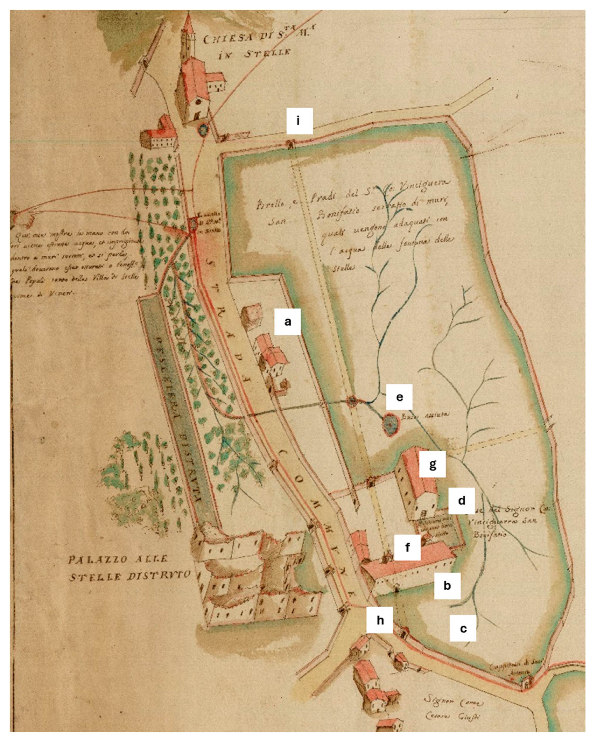
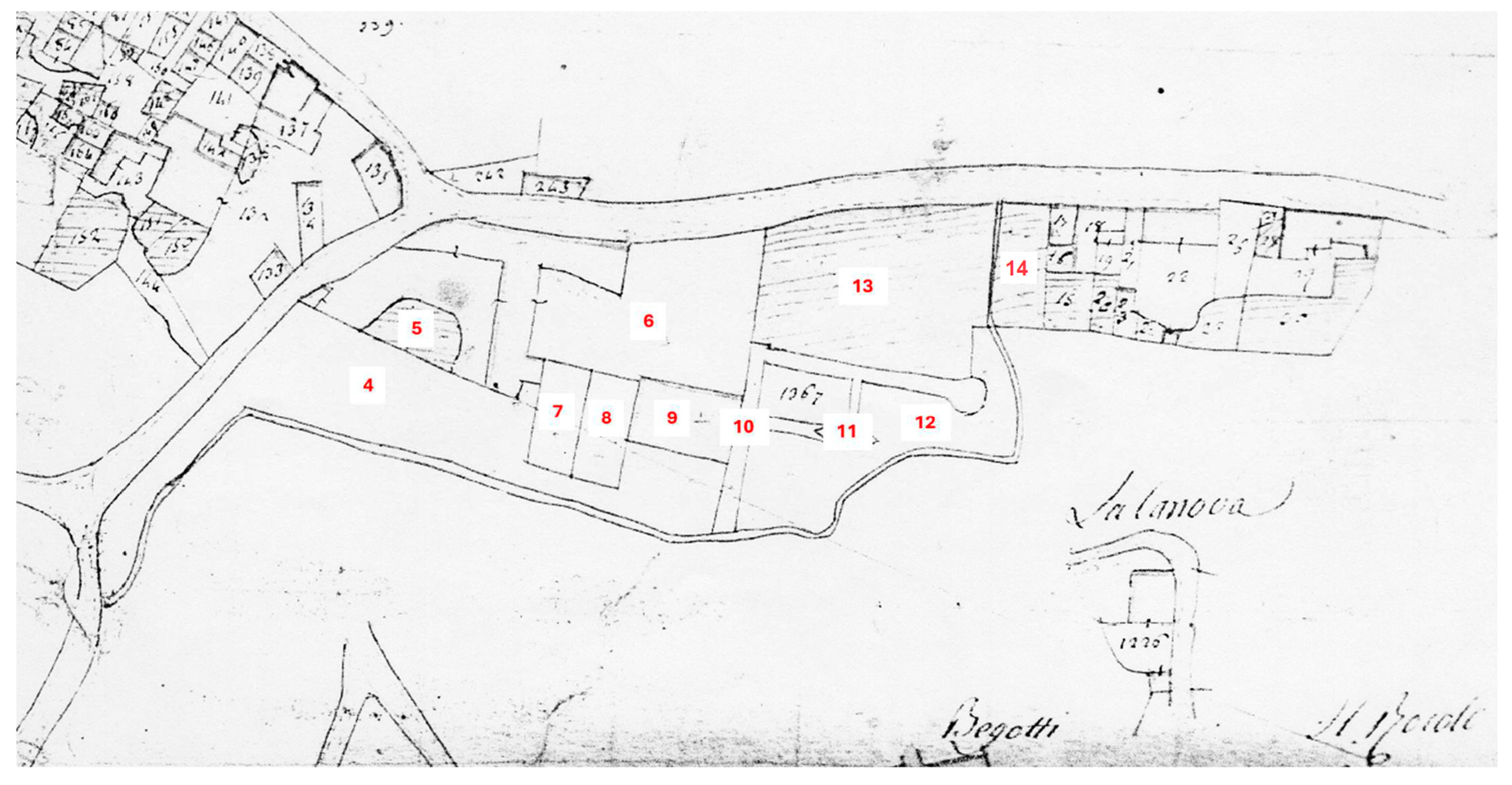
In the specific detail of the present Villa Giusti-Puttini in the 1735 map (Figure 10), some elements of interest for the interpretation of the villa appear: the first courtyard (a); the second courtyard (b) with an orchard enclosed by walls, to the south, the pigeon tower, an orchard enclosed by a wall at the site of the ancient fishpond (c) and the count manor (d), to the east, a boundary wall with a gate that leads to a pergola (e) covering the paths in the immediate vicinity of the manor house and leading to a third orchard enclosed by a perimeter wall (f) and to what could be the fishpond and fountain; and beyond the pergola, a wide brolo opens up (g). The nucleus of buildings built on the communal road seems to be consolidated with more buildings than on the previous map (h). To the south of the manor, an element appears that did not exist or had not been drawn on the maps until this time: a wall that runs along the path (i) to an access with pillars and spires (j), which seems to give more importance to this access than to the access from the municipal road and the western courtyard. The portal drawn in the south access (j) is clearly the one we find today in the west access, so we could have two explanations: either the portal was in the south access and after 1735 it was moved to the west access, or the map draftsman confused one access with the other. If one consults the previous maps (Figure 6 and Figure 8), it will appear that the western access to the courtyard was through an open doorway in the boundary wall, so that the rusticated portal may indeed have been inserted later in the present location. If this hypothesis were true, the southern access to the villa should have been more important than the other accesses at least in the 18th century. To the south of the manor, there seems to be a wall parallel to the manor house enclosing a garden (k). With respect to the accesses to the property, apart from the access from the south with the gate with pillars (j) and the access from the west through the courtyard (a), from the drawing, it would seem that the eastern access had been closed (l) while a new access from the communal road had opened in the north-eastern part of the brolo (m). Again, it is difficult to know whether this is an error or confusion on the part of the cartographer or a previous access opened in the north wall later disappeared. In the south-western corner, what in earlier maps might have looked like an access appears instead to be a niche (n) and may correspond to the niche that houses St. Anthony that was later to be moved to build the buildings on this spot.
The following drawing, by Giovan Battista Pallesina in 1798 (A.S.VR., Campagna Archive—B. 32, no. 337), once again related to the dispute over water distribution, is possibly much less accurate in terms of architecture and the rest of the landscape elements (Figure 11). The property of the present-day Villa Giusti-Puttini is defined as the “brolo of Count Maffei”. The drawing of the two courtyards and the villa’s manor is evidently approximate, while the circulation of water entering the property passing under the road seems to have remained intact, as has its circulation through the brolo to the exit from the property through the south-west corner. The circular fishpond and fountain are portrayed, as is the access to the property from the secondary road to the east of the villa.
From the 19th century, the property is documented in the Napoleonic cadastre of 1817 as the property of Uguccione Giusti, and in the Austrian cadastre from 1844 to 1894 as the “holiday home” of the Verdari family (1844–1894). From 1970 to the present day, the estate is owned by the Puttini family. The map of the Napoleonic Cadastre (Figure 12) shows the two successive courtyards with the buildings surrounding them described as the “foreman’s house with courtyard and oven”, the manor identified as “house of own use”, the pastures, the meadow avenue, the fish market, the vegetable gardens and the meadow with orchards.
In the map of the Austrian cadastre (1844–1890) (Figure 13), the first and second courtyards with the rustic buildings are both defined as “farmhouse”, the manor as “holiday home” and the orchard, the ploughed fields and the meadow are shown. In this map, there are no references to the fishpond, path or pergola. In both the Napoleonic and the Austrian cadastres, a double line dividing the brolo is maintained, which corresponds to a canalisation through which water circulated and which appears to be exactly the one on the 1625 map.
In the Italian cadastre (1896) the layout of the canal and the access to the brolo from the south are maintained. In the following updates to this cadastre, the major transformation is linked to the construction of the front of the houses located on the communal road between 1950 and 1970. A new property with a building in the north-eastern corner of what was the brolo of the villa also appears at the same time. In the 1971 EIRA map, in the same north-eastern corner appears the construction of two buildings and a plot in the lower part, cutting off a large part of its eastern edge from the property and its exit onto the corresponding road. Finally, it is in the following EIRA map of 1997 when the situation is definitively consolidated to the present day with the complete separation of the entire eastern part of the brolo at the current football pitch. This is the consolidated arrangement that we still find in the present map (Figure 14).

3.3. Historical Data for the Reconstruction of the Villa

The first clear description of the complex is found in the deed of contribution of the dowry of Zilia Campagna, widow of Bonsignorio Montagna, married in second marriage to Lelio Giusti in 1446. This description is followed by other succinct descriptions in the Giusti family documents [20,21,25]. The villa as a whole is described in greater detail in Pietro Avogaro’s letter (B.S.V.PD., doc. 1652, 647.I) written around 1495, of which a brief summary of the translation made by the authors of the text is given:
“The enclosure of the villa, called Justianum, located in the centre of the valley with the pond, fountains and gardens, is entered through a stone gate through two courtyards where, in the first and smaller courtyard, are the stables, the hayloft above, the cellar and the woodshed, while in the second and very large courtyard, there are the service buildings with the servants‘ quarters, the kitchen, the granaries, the fruit store, the larder, the oven, the aviary and the shelter where animals such as hares, chickens and rabbits are bred. On the other side of the courtyard is the lords‘ and guests’ manor house, adorned with marble and paintings, with regal entrances, noble porticoes, living rooms, bedrooms, winter and summer dining rooms with the windows of the rooms opening to the east towards the orchard and the olive-grown mountains, and to the west towards a large pool where fish swim and feed. Next to the manor house, on the side where the illustrious guest’s quarters are located, is a fine fountain with marble arches and columns on all the walls, and in the middle stands a Parian marble statue of Neptune, standing on a dolphin”.
It follows from this description that the villa described by Avogaro must not have been very different from the one depicted on the 1625 map (Figure 6). The configuration of the villa, as already observed by other authors [26], corresponds perfectly with the description made by the Bolognese Pietro De’ Crescenzi (ca. 1233-1320) in his De Agricultura, with respect to the “Intrinsic disposition of the court” [55], originally written around 1305, with later and still extant copies from between 1471 and 1495 [55]. Later transcriptions in Florentine were made, such as the one edited by Bartolomeo De Rossi [56], from which the following is paraphrased:
“The courtyard should be arranged in the middle and open on one side the entrance from the street and on the other, symmetrically, the exit to the farmyard, vineyard or fields. On one side of the road that divides the courtyard the lord’s house must be arranged with the long side facing the street and the short side that must not be very deep. (…) There, on the edge of the courtyard, arbour vines should be planted that will rise eight or ten feet above the ground, creating a beautiful arbour that is close to the trees. Nearby, fruit trees (figs, pomegranates, hazelnuts, jujubes and apple trees) are to be planted five or six feet from the courtyard, and further away, pear and apple trees are to be planted so that they bear fruit throughout the year. In the same place shall be built a delightful garden of fine and minute herbs, and there shall be kept the Lord’s garden, bees, and turtledoves (...). In the other half of the courtyard let houses and huts be built near the outer border, occupying one or two sides according to the need of the workers’ family and the animals. At the side of the workers’ house, the well and the oven should be built if a fountain did not already exist in the noblest part (...)”.
The description of the garden, the peach orchard, the vine arbour and the kitchen garden, named in the court layout, are taken up again later in the work (in Book VIII, the garden, the peach orchard and the arbour in Chapter III and the orchard in Chapter VIII). A paraphrased description is given briefly:
“For the garden of the Lords, a flat place with a spring will be chosen, which will spread around its places and will be enclosed with walls as high as is convenient. In the northern part, trees will be planted (called verziere) where animals can hide. In the southern part, the lords’ manor will be built so that it will shade the garden in summer and its windows will open onto the verziere. Also, there shall be made a fishpond where different kinds of fish shall feed, and there shall be placed hares, deer, rabbits and similar non-prey animals. And on certain bushes located near the manor, a house should be built with a thickly latticed copper wire roof and walls, where pheasants, partridges, nightingales, blackbirds, buntings, ferns and all kinds of birds that sing can be kept (...) A structure can be built of dry wood and vines can be planted around it, covering the whole building (...). Let it be set up in rich soil and irrigated with a fountain or a rivulet running between the separate spaces so that it can be maintained in times of great heat in order to nourish good herbs to eat, like medicine”.
The description shows how Villa Giusti-Puttini (Figure 15) was developed according to these same rules, either because they were known at the time or because the indications themselves were part of an established tradition at the time of its construction. The layout of the main courtyard follows the east–west and north–south axes, is divided into two parts with the noble part to the south and the workers’ part to the north and is enclosed between the buildings and the surrounding walls.
A detailed description of the park and garden, with its layout and botanical species present historically, is provided by Avogaro in his letter written in 1495 (B.S.V.PD., doc. 1652, 647.I):
“Here and there box trees, cedars, laurels crown the work of the gardener. The garden is separated from the outside and in that is a spring that gurgles continuously with a gentle murmur, next to which is a cistern that conveniently receives water flowing from the spring whenever it is thirsty. The spring is enclosed by a little theatre and those who sit there hear the murmur of the fountain. The following grow and feed in the garden: wisteria, cyclamen, heliotrope, crocus, black violet, lutea, iris versicolor, elderberry, acanthus, white lily, red lily, crocea… and all species besides the common ones, such as beetroot, buglosa, lettuce, envy, mint, pygenum, sage, rosemary, leek, solanum, serpyllum, ocynum, asparagus, cordum and many other hydrangeas. Thanks to this arrangement, and to the kindness of the roofs and the garden further away from the hill, the pause is completely offered to the astonished eyes of the guests, with myrtles, laurels, cedars and box trees, which are always green with their leaves, here the border is covered on both sides with vines that are supported by marble columns, to the right of those who enter there is a Christ, perfumed with violets and roses of various kinds and variously arranged seats, which, tired of walking, help the same pause. At the other end, and by the curve approaching the walls that enclose the pool here, come a large number of violets and roses. On the other side the peach and fig trees were often leafy, and on that side he made a fountain”.
In Avogaro’s description, we can imagine how the park of the villa at that time must have been divided into different parts: the walled garden with flowers, vegetables and medicinal herbs; the orchard with peach and fig trees; the veridarium or area with evergreen trees; and the fountains and pools. The park described is the place where the coexistence of flowers, fruit and leafy trees recalled the richness of Eden [11] and at the same time created a coexistence between the literary and leisure garden and the variety of fruit and vegetable crops necessary for the internal consumption of the villa [40].
The description mentions “a spring bubbling continuously with a gentle murmur, next to which is a cistern that conveniently receives water”. It is difficult to tell whether the spring was inside or outside the garden, but in any case, it must have been, if not inside, at least close by. It could be where the water enters the property through the north wall. Another element that is perhaps mentioned is the pergola that we might recognise in the description “the border is covered on both sides with vines that are supported by marble columns”.
The garden with flowers and medicinal herbs described in such detail by Avogaro must have been located on the north side of the park adjacent to the wall and is recognisable in the “garden” enclosed between walls visible on the 1625 map (Figure 15). In the 1683 map, the wall seems to remain, but the garden is not drawn; however, it reappears in the 1735 map showing it as an “orchard” but remaining enclosed between walls. The wall enclosing this space to the south with a supposed central gateway seems to disappear in the Napoleonic cadastre (1817), perhaps to extend the orchard that seems to reach as far as the path, an extension that seems to be maintained in the following cadastres. The garden of medicinal herbs and vegetables, enclosed between walls, clearly refers to the literary idea of the hortus conclusus [35], the protected garden of which there are numerous literary as well as pictorial references [37].
Another element described by Avogaro and present in historical maps is the pergola that, according to the 1735 drawing (Figure 10), covered the paths between the manor house, the garden, the fishpond and the fountain. The pergola must have existed because it is also drawn on the 1625 map, whereas it was not drawn on the 1683 and 1798 maps. As seen in De Crescenzi’s description, vine-covered pergolas were a common element of the late medieval and humanistic garden as can be seen in many of the garden illustrations of the time [37]. Among the illustrations, one drawing from De Agricultura [55] stands out: (Figure 16a) is a view of a garden enclosed by a wall and the pergola and fountain can be seen in the background. Two other drawings are worth mentioning. The first (Figure 16b), reported by Marchi [57], illustrates men of letters in the brolo of a Veronese villa: to the right of the pergola, the fishpond with two characters fishing reminds us of the spatial relationship between the pergola and the fishpond of Villa Giusti-Puttini. The last illustration (Figure 16c), from the publication Hypnerotomachia Poliphili by Francesco Colonna (1495), shows a pergola with a clear classical taste, with marble or wooden columns with classical forms and clearly wooden ribs for the transverse laths. This element is reminiscent of classical architecture and shows a clear humanist taste that initiates antiquarian culture [34]. Since this is the garden of Giusto Giusti, well known for his literary activity in the humanist environment of Verona, these two illustrations seem relevant as a reference for a possible pergola in the garden of his villa. Moreover, the depiction of the classical pergola reminds us of Avogaro’s description.
With respect to the statue of Neptune, king of the seas in Greek and Roman mythology, mentioned by Avogaro in his letter, there have been countless examples of this element since Roman times. Neptune was often placed in the centre of fountains and fishponds, and the statue of Neptune described by Avogaro, naked, of Parian marble (uniform white and fine grain), at whose feet stands a dolphin, vibrating his trident is entirely plausible. Strangely, this statue that so impressed Avogaro, does not appear in any other description or historical map. It could perhaps have been placed on the central element of the circular fishpond, clearly visible in the 1625 map (Figure 15), but it is difficult to go any further in the hypothesis with the information we have so far.
In the map of the villa dated 1625 (Figure 15), the fountain located in the centre of the park’s path appears to bear the inscription “Musa Caliope”, this figure being fully consistent with the profile of a literary and juristic lord such as Giusto Giusti was. The Greek muse Calliope is the muse of poetry and the goddess of eloquence that she bestowed on rulers and crowned with laurel. She is depicted with a waxed tablet or parchment and a stylus for writing. Unlike the statues of Neptune, which are very frequently associated with fountains, basins or springs, we have not found the presence of the muse Calliope linked to fountains. The fountain under discussion in the 1625 drawing would appear to be surrounded by a structure drawn with the line used for walls (continuous line and marron-coloured field). Again, however, the lack of certain data prevents a reliable hypothesis on the layout of the fountain.

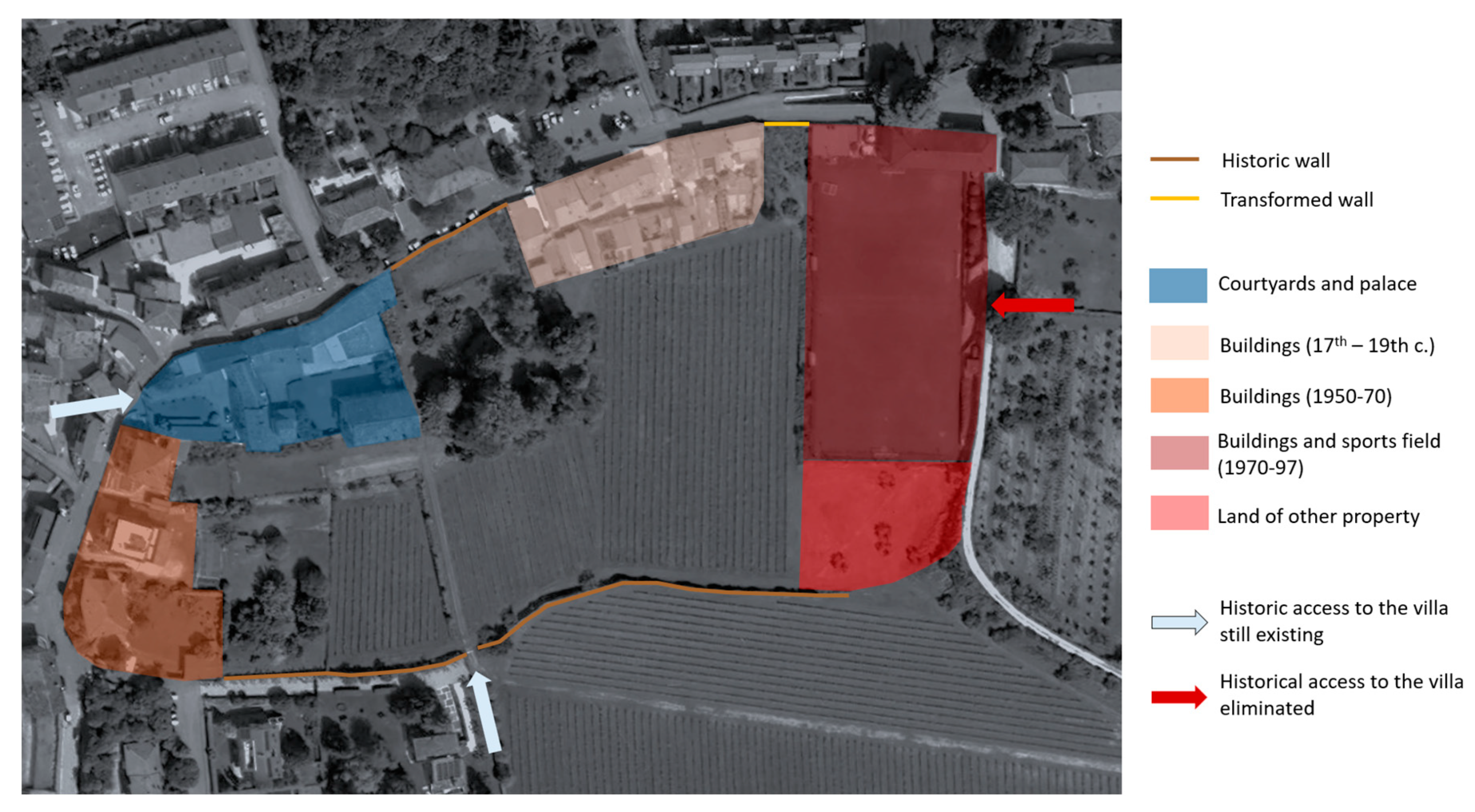
3.4. The Present Garden: Elements of Permanence and Absence

As can be appreciated through the study of historical maps, the villa has maintained a constant layout over time in the structure of the two courtyards, the outbuildings, the pigeon tower, the manor house and the parts of the garden in the immediate vicinity (Figure 17). The brolo of the villa is inextricably connected with the built part of the villa. The buildings are concentrated in the north-western part of the property area and create a visual reference in the landscape of the villa as a whole, as the tower in particular is visible from all parts of the brolo.
The transformation of the landscape took place progressively over the centuries (Figure 18): the construction of new buildings as early as the 17th century led to the formation of the two present-day courtyards; the loss of part of the brolo in the northern edge to the village from the 17th century onwards and then consolidated over the centuries to its current situation; the construction of buildings and private gardens in the western edge of the brolo that completely occupied the south-west corner of the property between 1950 and 1970; and the loss of the entire eastern strip of the brolo with the construction of the building in the north-east corner and the sports field from 1970 onwards.
If the occupation of the northern part of the brolo by the borough is of long standing and therefore, in a certain sense, an operation that has been metabolised by the villa, the interventions of the second half of the 20th century have opened new wounds in the layout of the whole area. The construction of the buildings in the south-west corner involved the elimination of the brolo wall and the removal of the niche of St. Anthony from the corner itself and its reinsertion on the other side of the street. The construction of the building in the north-east corner of the brolo involved the insertion of a large construction which, although in the extreme and barely visible from the building, constitutes an important element of impact on the whole area. The sports field, apparently harmless as a green element, completely eliminates the eastern access to the villa and truncates the path of the tree-lined path that once ran through the brolo from the fountain to the boundary wall in this position. The tree-lined path, or at least the path that led to the eastern exit, is depicted on historical maps up to 1798, and must have been a characteristic element of the park.
On the other hand, the presence in the park of certain elements allows traces of the park’s history to be found (Figure 19). These include the following: the northern and southern walls of the brolo, the southern access through the wall and the path through the brolo to the manor house surrounded by vineyards, the circular fishpond, the stone canals that still allow the water to flow, the possible remains of the fountain, the orchard that, although it has lost its surrounding wall, remains located where it was in the past, and the trees surrounding the fishpond.
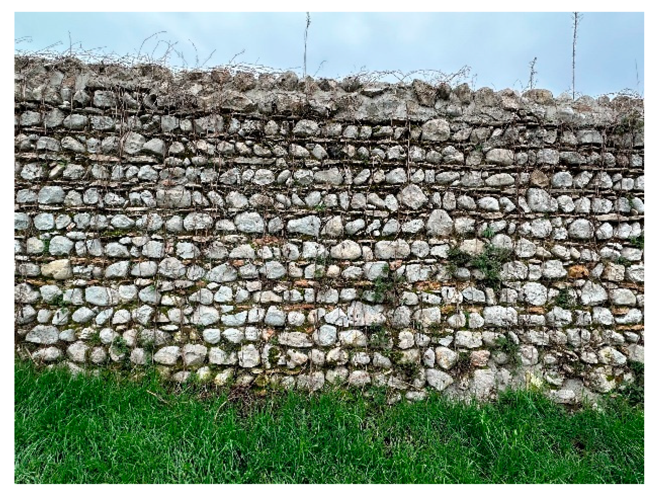
The built elements that characterise the park include the limits of the villa, the boundaries between its parts and some paths: the brolo wall (Figure 20), built with a masonry of limestone alternated with courses of flat red breccia; the path that joins the southern entrance and the manor, bordered by a terraced wall that saves the difference in height between the two parts of the brolo; and the wall that separates the main courtyard from the garden and the 
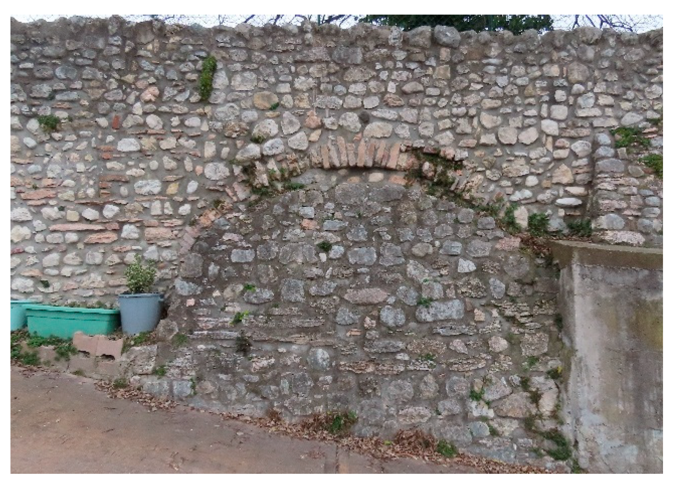
brolo that, despite later modifications, remains the constant boundary between the inhabited and cultivated parts of the villa. The wall of the brolo is lost to the west at the point where the football pitch is inserted, but it is precisely in the ramp that gives access to the football pitch that a section of the historic wall that closed the brolo to the east remains and possibly still preserves the hole of the ancient eastern access to the villa (Figure 21). Although this element materially remains, its total decontextualisation means that the east–west axis that characterised the brolo in the past has now been lost.
The map of 1735 (Figure 10) shows, as already commented, a rusticated entrance portal marking the southern entrance as a representative entrance to the villa. This is the access portal through which one enters the courtyard from the west side today and may, therefore, have been moved here at the time when this entrance was remodelled. Without having any concrete data on this fact, we could hypothesise that this alteration took place between 1950 and 1970 when the houses were built on the eastern boundary of the villa and, therefore, this whole side of the property was altered. Nevertheless, the emphasis that the rusticated portal gives to the southern entrance strongly marks the two perpendicular axes structure pointed out by De Crescenzi. At present, this axis of the villa is preserved, which starts from the same southern access and crosses the brolo to the manor house and then joins the east–west route leading into the courtyards.
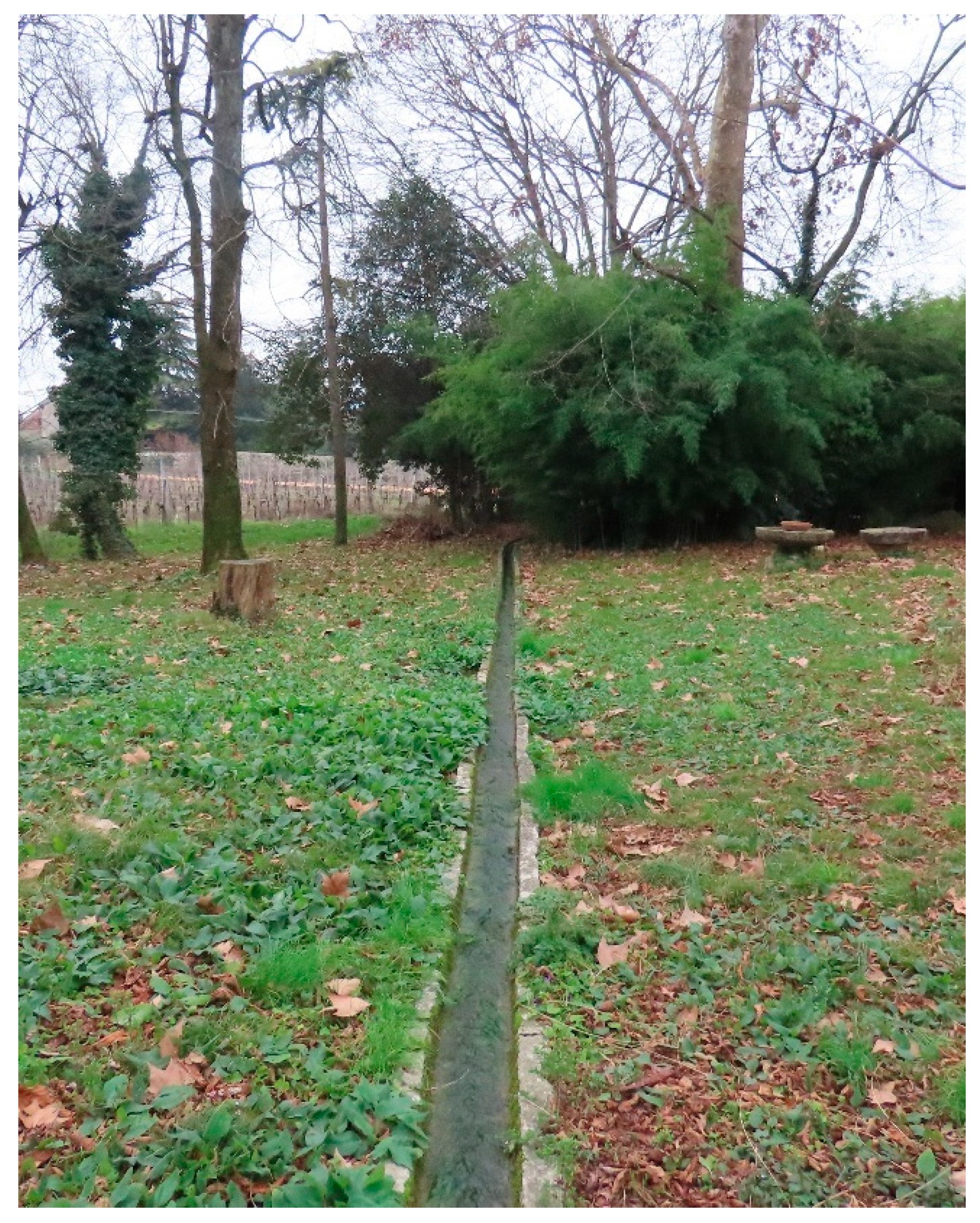
The waterway is undoubtedly one of the elements that most strongly characterises the landscape of the villa and which, although not entirely complete, remains as a strong mark across the centuries. The water comes from the natural spring that lies about 100 metres north of the Roman hypogeum [18]. The continuous slope of the land means that the water flows in stone canals probably built in Roman times from the mountain down to the valley. Along this route is the brolo of Villa Giusti-Puttini. The water route has been extensively depicted on historical maps from 1625 onwards (see Section 3.2) and has also been included in descriptions such as the letter written by Avogaro around 1495 (B.S.V.PD., doc. 1652, 647.I) (see Section 3.3). Some fundamental elements remain from this route, such as the water inlet on the property from the north side (Figure 22), the stone canals running along the brolo built with stone elements (probably a grey limestone from Noriglio, [58]) shaped in the form of a canal and connected together with very thin joints (Figure 23), the circular fishpond between the reeds also built with the same stone (
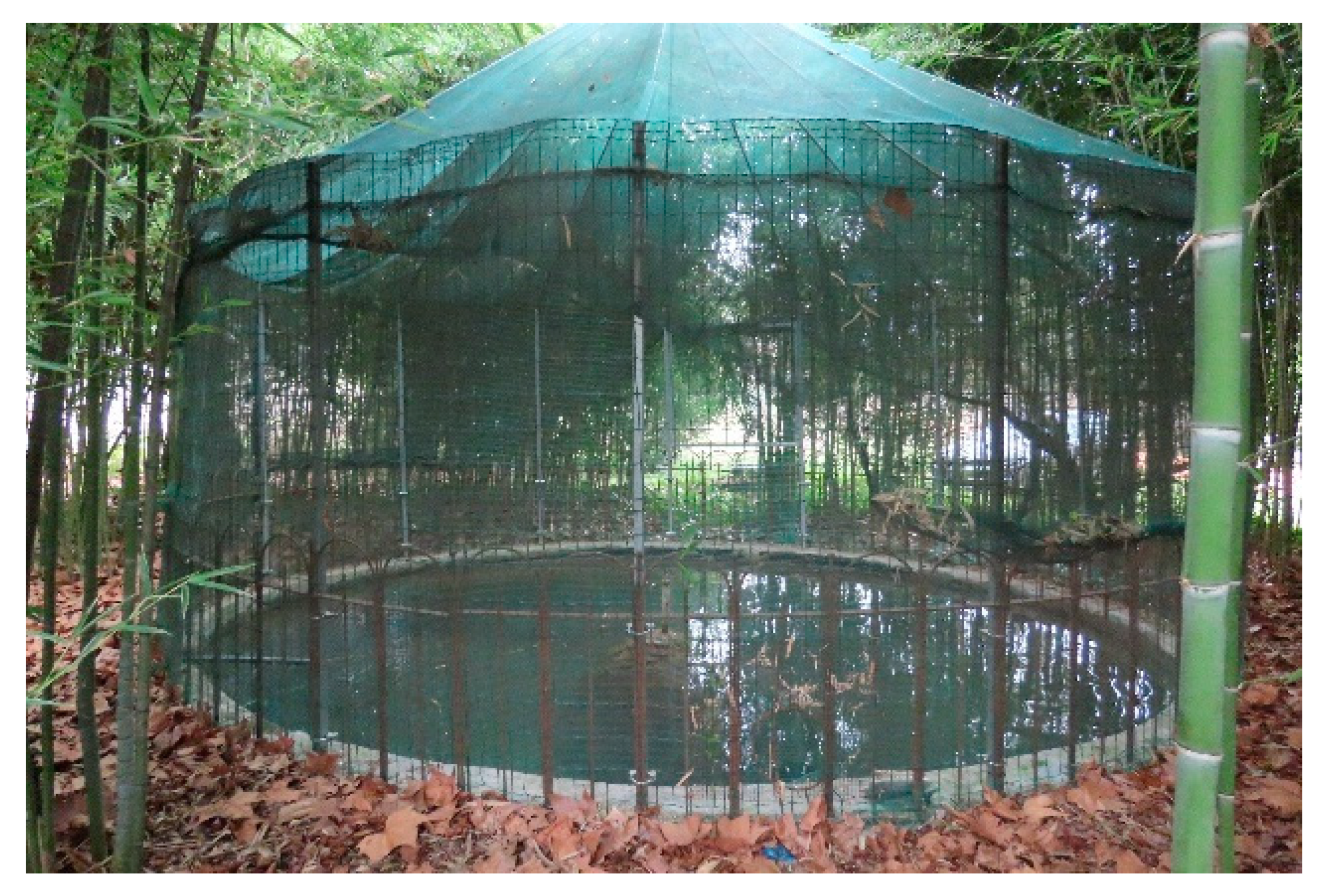
Figure 24) and the moat on the southern side of the manor house. The circular fishpond must have played a fundamental role in the organisation of the water flow and at the same time provided an element of coolness in the hottest periods. At the centre of the fishpond is a rocky cone on which a sculpture could be placed, perhaps the Neptune described by Avogaro. According to De Crescenzi’s description, the fishpond was not only a decorative element but also the place where the fish necessary to feed the family were raised.
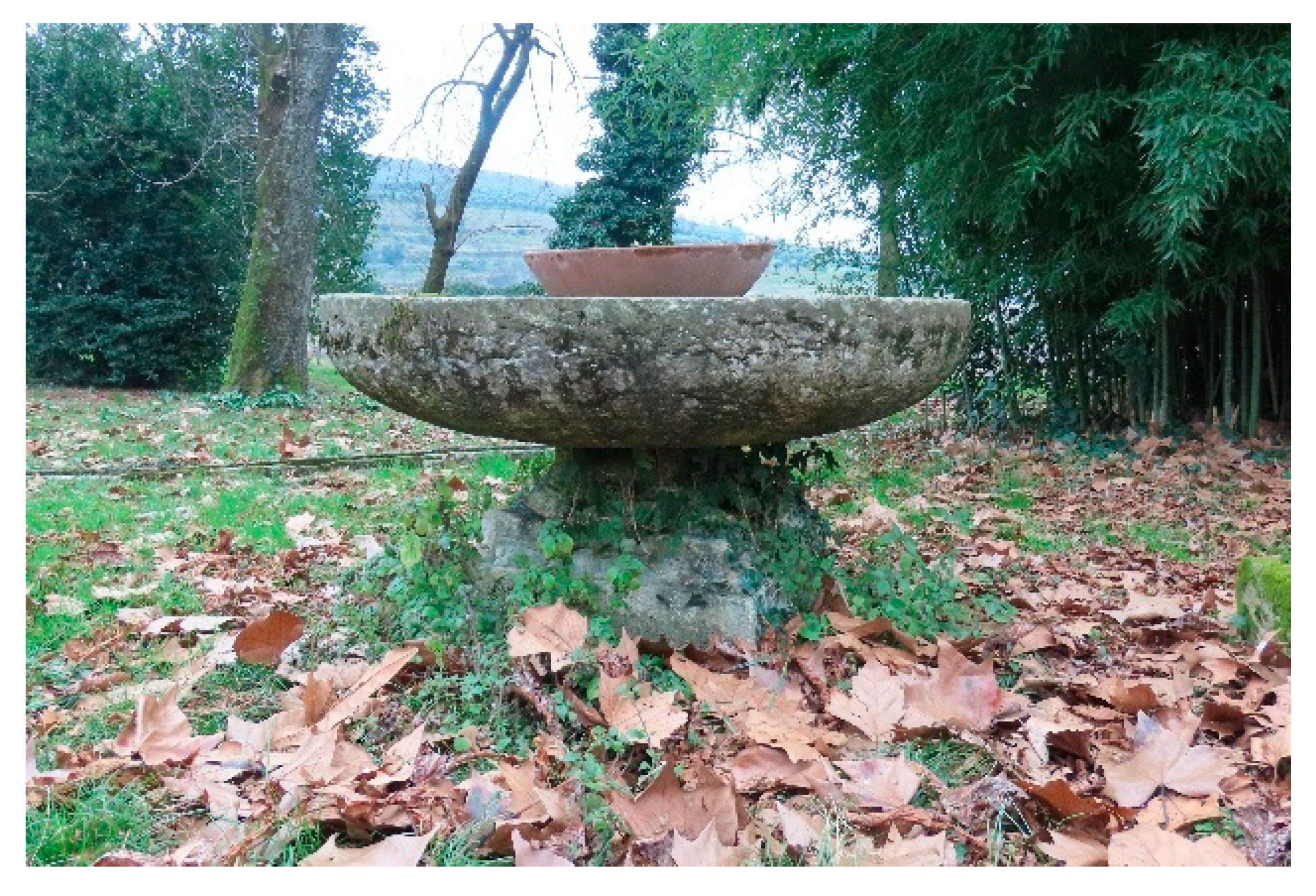
Other elements, however, have been lost, although traces of them remain: the fountain, known as the fountain of Calliope in the map of 1625, which can perhaps be identified in the lapidary fountain still existing in the garden (Figure 25), and the large rectangular fishpond, closed in 1683, of which there is no clear material trace except for the rectangular shape of the garden in front of the west façade of the manor house.
This large basin located between the west façade of the palazzo and the pigeon tower, depicted in 1625 as a pond surrounded by walls, was described in the 1683 plan as a “ruined fishpond now orchard”, in that of 1735 as an orchard and in that of 1798 as a garden. The presence of this pond would explain why there was initially no access door to the manor house from the west side, which only opened, as shown by its posteriority to the Renaissance frescoes [20], in a later period that could be identified as between 1625 and 1683. Among the stone fragments scattered in the park, one also encounters tombstones, most probably Roman, capitals that connect the villa to the former Roman settlements in the valley and the presence of a Roman necropolis, which should be studied archaeologically.
The park of the villa was evidently very much determined by the green elements. As we have seen, the letter written by Avogaro went in depth into the description of the garden rich in flowers, vegetables and herbs. This garden, judging by the map of 1625, was in the northern part of the property and delimited by a perimeter wall. It was a garden with four flowerbeds, a fountain in the middle and an underground canal that fed the fountain and nourished the plant life. This garden, now transformed into an orchard (Figure 26 and Figure 27), does not appear on either the 1683 or the 1798 map, but it does appear on the 1735 map where it is depicted as an orchard bounded by walls and with an access gate from the south side. It should be noted that the memory of the orchard remains today in the type of cultivation of this part of the garden. The perimeter wall was probably removed after 1735, but the location of the orchard remains in this same area to the present day.
In addition to the garden, there are other green areas in the brolo that deserve attention. Firstly, there is an area of leafy trees (Figure 19) to the east of the manor house, which could be interpreted as the “verziere” described by De Crescenzi, with large trees to shade the manor house. Beyond these trees, the vineyards now extend beyond the manor house and occupy the whole of the rest of the brolo. Vineyards are the main crop in Valpantena, already present in this valley since the Roman times and increased after the Venetian domination [59]. Its presence in the properties of the Giusti family has already been recorded in the map of 1598 where the lands of Vendri are defined as cultivated with vines. On the other hand, it is difficult to confirm that the Villa Giusti-Puttini brolo was dedicated to the cultivation of vineyards from a very early date. In the letter written by Avogaro, it is stated that “the windows of the rooms opening eastwards towards the fruit tree area and the mountains were planted with olive trees”, so perhaps the brolo was more destined to fruit trees and perhaps the surrounding fields to the cultivation of vineyards, while on the hills above, olive trees were cultivated. The hypothesis that the brolo was largely cultivated as an orchard is also supported in the advice given by De Crescenzi regarding cultivation for the villas. The orchard, with figs, pomegranates, hazelnuts, jujubes, pear and apple trees allowed for fresh fruit throughout the year. Nevertheless, the extension of Villa Giusti-Puttini’s brolo would have perfectly allowed the fruit trees and the vineyards to coexist.

4. Discussion

The research presented in this text has made it possible to reconstruct the history of the villa over the centuries thanks to the analysis of historical documents and historical maps. The park of villa Giusti-Puttini is a living organism that has passed through the centuries and is a witness of the ways in which Venetian and Veronese families interacted with nature and established a bridge between agricultural production and a place of pleasure, tranquillity and leisure. As we have seen, following the study carried out, it has been possible to demonstrate how the park drawn on the map of 1625 is still very much like what the park must have been in the 16th century, the refuge of the businessman or politician who withdraws from city work and public life to find intellectual tranquillity and the inspiring company of other intellectuals in a dominated and controlled nature [11].
The park comprises several areas with different functions: the horto or enclosed medicinal herb and vegetable orchard; the pomarium or fruit tree area; the viridarium, as an area of large trees that provide shade for the garden and the building; and the brolo, as a cultivation area protected by the wall, that separates it from the rest of the cultivated fields and from the more distant hills that surround the villa like a natural theatre. The architecture of the garden was based on pergolas of vines and vegetation defining the space. The park of Villa Giusti-Puttini, despite the successive transformations studied in this text both in terms of documents and through the elements that remain in the complex, maintains the landscape structure of the 15th and early 16th centuries, keeping them fairly intact. The structure that can be identified in this villa is clearly linked to the indications of De Crescenzi, published in Venice in 1495 [55], a productive villa with some concessions to the leisure of the lords. Perhaps we can also find in it some aspects more closely linked to the garden of leisure described by Leon Battista Alberti in the relationship between the manor house and the garden (large windows to enjoy the garden, the pergolas linking the house to the garden) or in the concept of the garden of medicinal and aromatic herbs closer to the medieval garden also described by Francesco Colonna [36].
But despite the permanence of some relevant elements, important changes and transformations have also been detected in the park (see Section 3.4). These transformations bear witness to the passage of time, the changes in ownership and the changes in the management of the villa, which went from being a productive and leisure villa (16th and 17th centuries) to a primarily productive property (18th century), a holiday or second home (19th century) and a church-owned residence (first half of the 20th century). Despite the changes in use and ownership, the structure of the villa remained practically unchanged until the mid-1950s. From that time onwards, external pressures and the rapid transformation of the territory linked to the transformation of the rural landscape [60] modified the borders of the property (construction of the chalets in the western part of the brolo, the football pitch in the eastern part and the parish building in the north-eastern corner).
The research presented in this article has shown the heritage relevance of the village and its park as a historic landscape. The villa is currently protected according to local regulations, both in its buildings and in a part of the historic garden. The villa was catalogued in the Regional Institute of Veneto Villas in 2007 thanks to the provincial catalogue created in 2003. In the landscape map of the Plan of Interventions [61], Villa Giusti-Puttini is subject to the following constraints: the manor house is identified as a “catalogued Veneto villa and its appurtenant area”; the buildings built on the property and part of the garden immediately adjacent to the buildings are catalogued as “minor historic centres”; the garden in the eastern part of the manor is catalogued as a “historic garden”; and the land corresponding to the ancient brolo of the villa as a whole, including the buildings built later, is identified as a “figurative context of villas/courtyards/historic buildings in the open landscape”.
The state of conservation of the villa, combined with the constraints to which it is subject, opens up an opportunity to reason about the conservation not only of the built part (the manor house, pigeon tower and buildings around the courtyards) already studied [20,25] but also with respect to the historic garden and the brolo as a whole as fundamental elements of the cultural heritage.
In the Charter for the Preservation of Historic Gardens [45], a historic garden, understood as the connecting element between culture and nature, is defined as “an architectural and vegetal composition that from the historical or artistic point of view is of public interest” and since the “material is mainly vegetal, therefore living and as such perishable and renewable”, its appearance is linked to “a perpetual balance, in the cyclical course of the seasons, between the development and decay of nature and the will of art and artifice that tends to preserve its state in perpetuity” [45]. According to the same document, with respect to the interventions to be carried out, it is worth remembering that “any restoration and even more so any restoration of a historic garden should only be undertaken after an in-depth study ranging from the excavation to the collection of all the documentation concerning the garden and similar gardens, capable of ensuring the scientific character of the intervention” and “the restoration intervention must respect the evolution of the garden in question. As a principle, one period may not be favoured at the expense of another unless the deterioration or decay of certain parts may exceptionally be the occasion for a restoration based on vestiges or irrecusable documents. In particular, the parts of the garden closest to a building may be the object of possible restoration, in order to bring out its coherence”.
Following these principles, the conservation of the Villa Giusti-Puttini park can be the recovery of a history of fragments and visual elements that guide the gaze between nature and the history of the place. The present elements can guide the interpretation of the memory of the absent elements, rediscovering a history of people, places, relationships and culture. Therefore, the park could be enhanced with a series of interventions for the conservation of the existing elements and the recovery of some historical elements of which there is extensive written and graphic documentation. It is therefore possible to establish three main lines of intervention.
Firstly, the recovery of the historical paths that existed as much (southern access, paths around the fishpond) as recoverable (path to orchard, cypress path): these elements articulated the park and can be an element that allows the park to be read as a park of a Veneto villa of idleness and production where the park was both a garden and cultivated brolo. The cypress path, long since disappeared, could recover the historical dimension of the park that is currently lost in the vineyards. Even if the eastern access to the brolo cannot be recovered, the recovery of the avenue would help us to understand the whole. The possibility of partially or totally recovering the pergola as a fundamental element of the garden should also be considered. It is, as we have seen, an element that was maintained at least until 1735 and was fundamental in delimiting the part of the garden dedicated to leisure. The recovery of these paths would constitute the recovery of the memory of the villa but at the same time would serve to re-establish the relationship between the various parts of the brolo and its connection with the surrounding territory [3]. These connections have been lost especially during the 20th century with the insertion of strange elements such as the houses situated to the west, the sports field to the east and the construction of new houses to the south occupying the cultivated fields.
Secondly, the recovery and maintenance of the water trail as an element that has always been a determining feature of the park and the fundamental bond between the villa and its territory. Water united the villa with the rest of the Giusti family properties and with the source of the hypogeum. The recovery of the complete water route would help us to understand this relationship between the villa and the territory. The water route consists of the canalisations, the circular fishpond, the fountain and the large rectangular fishpond. The canalisations are almost complete and can be easily maintained, as can the circular fishpond. The rectangular fishpond, already eliminated in the 17th century, can hardly be salvaged, but one could perhaps recover its trace at the level of vegetation or paving. A small archaeological survey would be necessary to verify its perimeter. The research carried out has highlighted the importance of water as a territorial connector, as a resource for supplying the countryside and as a recreational element within the manor villas. Therefore, water and its management in the territory (route, canalisation, use, etc.) constitute a key to understanding the landscape of the villas of the Veneto and their history. Water infrastructure is named in the Charter for the Preservation of Historic Gardens [45], but more consideration should be given to establishing strategies for its maintenance and restoration.
Thirdly, the recovery of the orchard as a defining element of the renaissance park that was present in the villa at least until 1735 with more or less personality. It must have been a hortus with flower and herb beds that then remained as an orchard in a generic form. The boundary wall also seems to have survived at least until 1735. It would be convenient to recover this element, probably delimiting it with plant elements without the need to reconstruct a wall of which we have no precise knowledge. With respect to the canals that ran within it and that were part of the water route, it would be appropriate to make a more detailed survey to verify their level of permanence. The re-establishment of the balance between the various parts of the brolo and its territory (horto, pomarium, viridarium, in addition to the crops inside the brolo, fields around the villa, as well as the natural wooded hills beyond the fields) constitutes a factor for rethinking the variety of the historical landscape not only in this area but in the whole of Veneto. The diversity of crops, as well as the diversity of functions (agricultural and recreational) contrast with the monocultures that have been imposed throughout the 20th century [3]. Today, the villa system is not only an example of architectural and landscape heritage but also a model of self-management, self-sufficiency and crop variety.
Lastly, the villa is currently still privately owned and it is intended to seek compatibility between residential use and a possible opening to the public for visits to the site or small events. In this sense, it could be appropriate to promote the southern access to the brolo as a public access, thus separating it from the private access to the residential court. The coexistence of private activities (residence, cultivation, agricultural activities) and public activities (visits, events, etc.) could also help to raise funds for the maintenance of the villa [44]. Finally, it is currently impossible to recover the areas lost on the west side, where several cottages were built before the 1970s, and on the east side, where the sports field is located, which is a public facility. Although these elements appear as an aggression and an invasion of the perimeter of the brolo, they are now irreversible historical facts and the villa has to learn to live with them without renouncing its character.

5. Conclusions

The research presented in this article has employed a complex methodology that has combined the analysis of historical maps and archival documents with the direct study of a cultural and historical heritage of great importance such as the Giusti-Puttini villa in Santa Maria in Stelle in the province of Verona. The research carried out has led to an in-depth knowledge of the object of study in its current situation, of the transformations it has undergone over time and of the cultural contexts that have shaped and transformed it. The journey through historical maps and archival documents has allowed for a deeper interpretation of the elements of the landscape, territorial connections and uses, as well as highlighting the historical significance of the place and of the villa.
The comparison between the historical documentation and the current situation of the villa has made it possible to establish the elements of permanence and absence as integral parts of the life of the park. Boundaries, axes, paths, accesses and green areas of the park remain in its structure, as well as the route of the water, which is one of the most characteristic elements of the complex both in its interior and in its territorial relationship that connects this villa with the other villas owned by the same family. Some of these elements, such as the brolo wall, the courts with their buildings, the tower, the fishpond, the paths, the canalisations, are clearly visible and make up the landscape. Others, such as the stone elements scattered around the park or embedded in the walls, are reduced to scattered fragments that need to be reconnected with history.
On the basis of these elements of study and with the aim of reconnecting with the memory of the place, stitching together the fragments and recovering a landscape ensemble of great historical and cultural interest that is connected with the history of the Veneto territory and its management over the centuries, guidelines are established for the conservation and enhancement of the park of the villa.
This study also opens up new possibilities and lines of research both in the particular case of Villa Giusti-Puttini and the five villas located in Santa Maria in Stelle and in general. In the case study of Villa Giusti-Puttini, once the historical documentation has been analysed and compared with the built reality, this second aspect can be studied in greater depth thanks to new technologies such as GIS or the detailed study of plant species to check their age and permanence in the villa’s brolo. This line of research could open new horizons for both knowledge and conservation. In addition, the route of water and its management can be further explored. This aspect can be studied in the whole area of Santa Maria in Stelle and also in the area of the hills to the north of the city of Verona dotted with castles and villas, as elements of a continuity in the management of the territory over the centuries.
Finally, the proposed methodological approach transcends this specific case and aims to establish a methodology that, by combining the study of documentary and archival sources with the direct sources of the heritage asset, through the concept of permanence and absence, suggests a path for the conservation of the cultural landscape applicable to other cases both in the same cultural environment and in other areas.

Author Contributions

Conceptualisation: C.M.; methodology, C.M. and F.V.; documental research: C.M.; on-site research: C.M. and F.V.; photos: C.M. and F.V.; drawings: C.M. and F.V.; writing—original draft preparation: C.M. and F.V.; writing—review and editing, C.M. and F.V. All authors have read and agreed to the published version of the manuscript.

Funding

This research was self-funded by the authors.

Data Availability Statement

The original contributions presented in this study are included in the article. Further inquiries can be directed to the corresponding author.

Acknowledgments

This research was made possible thanks to the kindness of the owners of Villa Giusti-Puttini, who readily allowed the authors access to the villa at all times.

Conflicts of Interest

The authors declare no conflicts of interest.

Appendix A. Documents and Archives

  • Archivio di Stato di Venezia (A.S.VE.):
    • A.S.VE., Beni Inculti—Verona, rot. 102, mazzo 86, dis. 5
    • A.S.VE., sez. Fotoriproduzioni—Beni Inculti, Verona—rot. 74, mazzo 64, dis. 5
  • Archivio di Stato di Verona (A.S.VR.):
    • A.S.VR., Archivietti Privati, Giusti, Arch. 34, vol. I; foglio 213r-213v
    • A.S.VR., Archivietti Privati, Giusti, Arch. 34, vol. I; foglio 27r-29v
    • A.S.VR., Archivietti Privati, Giusti, Arch. 34, vol. II; foglio 19r-22r
    • A.S.VR., Archivio Campagna, B. 13, n. 154
    • A.S.VR., Archivio Campagna, B. 13, n. 155
    • A.S.VR., Archivio Campagna, B. 13, n. 337
    • A.S.VR., Archivio Campagna, B. 32, n. 337
    • A.S.VR., Catastro Austriaco—Santa Maria in Stelle, funda 61
  • Biblioteca del Seminario Vescovile di Padova (B.S.V.PD.)
    • B.S.V.PD., doc. 1652, 647.I (author: Pietro Avogaro; year: 1495)

References

  1. Thiriet, F. Storia della Repubblica di Venezia; Marsilio: Venice, Italy, 1981. [Google Scholar]
  2. Azzi Visentini, M. Il paesaggio delle Ville Venete tra ragione e sentimento. Paesaggi di villa. Architettura e Giardini nel Veneto; Rallo, G., Cunico, M., Azzi Visentini, M., Eds.; Marsilio: Venice, Italy, 2015; pp. 12–27. [Google Scholar]
  3. Rallo, G. Le acque, la campagna e i sistemi di villa nel Veneto. Bellezza e Produttività nel Giardino e nel Paesaggio Rurale Italiano; Pietrogrande, A., Ed.; Leo S. Olschki: Padova, Italy, 2024; pp. 45–56. [Google Scholar]
  4. Cosgrove, D. Il Paesaggio Palladiano; Cierre Edizioni: Verona, Italy, 2000. [Google Scholar]
  5. Zalin, G. (Ed.) Economia agraria e insediamento di villa nel veronese tra medioevo e Rinascimento. In Terre e Uomini nel Mediterraneo e in Europa; Libreria Universitaria Editrice: Verona, Italy, 1990; pp. 265–304. [Google Scholar]
  6. Casti, E. State, Cartography, and Territory in Renaissance Veneto and Lombardy. The History of Cartography; Woodward, D., Ed.; The University of Chicago Press: Chicago, IL, USA, 2007; pp. 874–909. [Google Scholar]
  7. Ventura, A. Aspetti storico-economici della villa veneta. In Bollettino del Centro Internazionale di Studi di Architettura Andrea Palladio; Centro Internazionale di Studi di Architettura “Andrea Palladio”: Vicenza, Italy, 1969; pp. 65–77. [Google Scholar]
  8. Sandri, G. Le origini della villeggiatura. In Bollettino Della Società Letteraria di Verona; Società Letteraria di Verona: Verona, Italy, 1931. [Google Scholar]
  9. Kubelik, M. Palladio’s Villas in the Tradition of the Veneto Farm. Assemblage; The MIT Press: Cambridge, MA, USA, 1986; pp. 90–115. [Google Scholar] [CrossRef]
  10. Bödefeld, G.; Hinz, B. Ville Venete; Idealibri: Milan, Italy, 1990. [Google Scholar]
  11. Barbieri, G. I Giardini delle Ville Venete. Un Nuovo Sguardo; Terra Ferma: Treviso, Italy, 2015. [Google Scholar]
  12. Rosci, M. Ville rustiche del Quattrocento veneto. In Bollettino del Centro Internazionale di Studi di Architettura Andrea Palladio; Centro Internazionale di Studi di Architettura “Andrea Palladio”: Vicenza, Italy, 1969; pp. 79–93. [Google Scholar]
  13. Ruprecht, B. Ville venete del ‘400 e del primo ‘500: Forme e sviluppo. In Bollettino del Centro Internazionale di Studi di Architettura Andrea Palladio; Centro Internazionale di Studi di Architettura “Andrea Palladio”: Vicenza, Italy, 1964; pp. 239–261. [Google Scholar]
  14. Zancan, M.A. Le ville vicentine del Quattrocento. In Bollettino del Centro Internazionale di Studi di Architettura Andrea Palladio; Centro Internazionale di Studi di Architettura “Andrea Palladio”: Vicenza, Italy, 1969; pp. 430–446. [Google Scholar]
  15. Monicelli, F. Ville Veronesi. Un Racconto per Immagini Attraverso i Secoli; Cierre Edizioni: Verona, Italy, 2025. [Google Scholar]
  16. Rallo, G. Giardini tra ville e campagna. Da luoghi dell’otium alla villeggiatura. In I Giardini delle Ville Venete; Zanarotti, C., Ed.; Silvana Editoriale: Milan, Italy, 2014; pp. 9–13. [Google Scholar]
  17. Turri, E. La Conoscenza del Territorio. Metodologia per un’Analisi Storico-Geografica; Marsilio: Venice, Italy, 2002. [Google Scholar]
  18. Antolini, L. L’Ipogeo di Santa Maria in Stelle in Valpantena; GBE: Verona, Italy, 2020. [Google Scholar]
  19. Viviani, G.F. La Villa Nel Veronese; Banca Mutua Popolare di Verona: Verona, Italy, 1975. [Google Scholar]
  20. Mileto, C.; Vegas, F. Fragments for the History of an Architecture: A Villa between Humanism and the Renaissance. Architecture 2023, 3, 358–392. [Google Scholar] [CrossRef]
  21. Ferrarin, P. Bartolomeo Ridolfi. Bachelor’s Thesis, Istituto Universitario di Architettura di Venezia, Venice, Italy, 1988, unpublished. [Google Scholar]
  22. Mileto, C. Las villas vénetas de los siglos XV y XVI: Entre tradición e innovación arquitectónica. In Palladio 1508–2008; Arnau, J., Ed.; TC Cuadernos: Valencia, Spain, 2008; pp. 169–195. [Google Scholar]
  23. Monicelli, F. Santa Maria in stelle: Un borgo del Rinascimento. In Architettiverona; Ordine degli Architetti di Verona: Verona, Italy, 2022; pp. 74–81. [Google Scholar]
  24. Dal Forno, F. Ville e dimore nella Valpantena. In La Valpantena: Secondo Quaderno Culturale; Scudo Editore: Verona, Italy, 1987; pp. 9–99. [Google Scholar]
  25. Mileto, C. Il Palazzo Dominicale di Villa Giusti-Puttini a Santa Maria in Stelle (Verona): Conoscenza del Manufatto e Progetto di Restauro. Bachelor’s Thesis, Istituto Universitario di Architettura di Venezia, Venice, Italy, 1998. [Google Scholar]
  26. Lodi, S. Lodi, S. Lo Iustianum: Una villa umanistica nei pressi di Verona. In Italia Medievale e Umanistica; Antenore: Verona, Italy, 1999; pp. 207–263. [Google Scholar]
  27. Lodi, S. VR 669. Villa Giusti, Puttini. In Ville Venete: La Provincia di Verona; Ferrari, S., Ed.; Marsilio: Padua, Italy, 2003; pp. 799–801. [Google Scholar]
  28. Monicelli, F. 146. Villa Giusti “Ai Casai”; 147. Villa Giusti, Bianchini; 148. Santa Maria in Stelle. Villa Giusti, Puttini. In Gli affreschi nelle Ville Vénete. Il Cinquecento; Pavanello, G., Mancini, V., Eds.; Marsilio: Padua, Italy, 2008; pp. 469–475. [Google Scholar]
  29. Mileto, C. Coordenadas de las villas prepalladianas: Los albores de las villas vénetas. In Asimetrías; Universitat Politècnica de València: Valencia, Spain, 2002; pp. 5–33. [Google Scholar]
  30. Rigon, F. Torri medioevali come primi nuclei di insediamento in villa. In Bollettino del Centro Internazionale di Studi di Architettura Andrea Palladio; Centro Internazionale di Studi di Architettura “Andrea Palladio”: Vicenza, Italy, 1969; pp. 387–392. [Google Scholar]
  31. Borelli, G. Un Patriziato Della Terraferma Veneta tra XVII e XVIII Secolo; Giuffré: Milan, Italy, 1974. [Google Scholar]
  32. Puppi, L. Funzioni e originalità delle ville veronesi. In La Villa Nel Veronese; Viviani, G., Ed.; Banca Mutua Popolare di Verona: Verona, Italy, 1975; pp. 87–140. [Google Scholar]
  33. Varanini, G.M.; Postinger, C.A.; Lazzarini, I. Il territorio veronese, trentino e mantovano. In Verona e il suo Territorio nel Quattrocento. Studi Sulla Carta dell’Almagià; Lodi, S., Varanini, G.M., Eds.; Cierre: Verona, Italy, 2014; pp. 61–110. [Google Scholar]
  34. Vercelloni, V. Atlante Storico dell’idea del Giardino Europeo; Jaca Book: Milan, Italy, 1990. [Google Scholar]
  35. Baridon, M. Les jardins. Paysagistes—Jardiniers—Poètes; Robert Laffont: Paris, France, 1998. [Google Scholar]
  36. Kluckert, E. Grandes Jardines de Europa; Köneman: Colonia, Germany, 2000. [Google Scholar]
  37. Valery, M.F. Le Toquin, A. Jardins du Moyen Âge; Dexia: Bruxelles, Belguique, 2001. [Google Scholar]
  38. Zanarotti, C. I Giardini delle Ville Venete; Silvana Editoriale: Milan, Italy, 2014. [Google Scholar]
  39. Rallo, G.; Cunico, M.; Azzi Visentini, M. Paesaggi di Villa. Architettura e Giardini nel Veneto; Marsilio: Venezia, Italy, 2015. [Google Scholar]
  40. Svalduz, E. Architettura e Paesaggio: La villa veneta nel Rinascimento. In Paesaggio Veneto nel Rinascimento Europeo; Caracausi, A., Grosso, M., Romani, V., Eds.; Officina Libraria: Milan, Italy, 2019; pp. 133–150. [Google Scholar]
  41. Doglioni, F. Palladio’s villa Saraceno. Twenty years after the restoration. In Loggia—Arquitectura y Restauración; Universitat Politècnica de València: Valencia, Spain, 2016; pp. 102–117. [Google Scholar]
  42. Petriccione, L.; Bulfone Gransinigh, F. Ville venete, una risorsa per lo sviluppo culturale ed economico del territorio. In Sguardi ed Esperienze Sulla Conservazione del Patrimonio Storico Architettonico; Della Torre, S., Borgarino, M.P., Eds.; Nardini: Florence, Italy, 2014; pp. 235–246. [Google Scholar]
  43. Tempesta, T. La degenerazione del paesaggio delle ville venete. In Atti dell’Accademia dei Georgofili; Accademia dei Georgofili: Florence, Italy, 2018; pp. 231–234. [Google Scholar]
  44. Muratori, G. Villa veneta: Risorsa economica per il terriorio. In Turismo e Psicologia; Università di Padova: Padova, Italy, 2015; pp. 65–69. [Google Scholar]
  45. ICOMOS. Historic Gardens. The Florence Charter; ICOMOS: Paris, France, 1981. [Google Scholar]
  46. Lian, J.; Nijhuis, S.; Bracken, G.; Wu, X.; Wu, X.; Chen, D. Conservation and development of the historic garden in a landscape context: A systematic literature review. Landsc. Urban Plan. 2024, 246, 105027. [Google Scholar] [CrossRef]
  47. Jagiełło, M. Do we need a new Florence Charter? The importance of authenticity for the maintenance of historic gardens and other historic greenery layouts in the context of source research (past) and taking into account the implementation of the sustainable development idea (future). Sustainability 2021, 13, 4900. [Google Scholar] [CrossRef]
  48. Pietrogrande, A. (Ed.) Bellezza e Produttività nel Giardino e nel Paesaggio Rurale Italiano; Leo S. Olschki: Padova, Italy, 2024. [Google Scholar]
  49. Funsten, C.; Borsellino, V.; Schimmenti, E. A systematic literature review of historic garden management and its economic aspects. Sustainability 2024, 12, 10679. [Google Scholar] [CrossRef]
  50. Hosseini, Z.; Caneva, G. Lost gardens: From knowledge to revitalization and cultural valorization of natural elements. Sustainability 2022, 14, 2956. [Google Scholar] [CrossRef]
  51. Padilha, M.; Bellaguarda, M.; Nelson, S.; Maia, A.; Costa, R. The use of sources in historical research. Texto Contexto Enferm. 2017, 26, e2760017. [Google Scholar]
  52. Chelidonio, G. Ritrovamenti paleolitici sulla dorsale Ovest della Valpantena (Verona). In Quaderni di Archeologia del Veneto; Cierre: Verona, Italy, 2004; pp. 56–61. [Google Scholar]
  53. Gangale Risoleo, D. Water for men or water for the Gods? The caput aquae of the aqueduct of Santa Maria in Stelle (Verona). Groma 2023, 8, 76–99. [Google Scholar] [CrossRef]
  54. Lodi, S.; Varanini, G.M. Verona e il suo Territorio nel Quattrocento. Studi sulla Carta dell’Almagià; Cierre: Verona, Italy, 2014. [Google Scholar]
  55. De Crescenzi, P. De Agricoltura; Venezia, 1495. Available online: https://archive.org/details/pierocrescentiod00cres (accessed on 27 July 2024).
  56. De Rossi, B. Trattato della agricoltura di Piero de’ Crescenzi, Traslatato Nella Favella Fiorentina (1585–1605); Società Tipografica de’ Classici Italiani: Milan, Italy, 1805; Available online: https://babel.hathitrust.org/cgi/pt?id=nyp.33433007627106&seq=134 (accessed on 27 July 2024).
  57. Marchi, G.P. Letterati in villa. La villa nel veronese; Viviani, G.P., Ed.; Banca Mutua Popolare di Verona: Verona, Italy, 1975; pp. 231–252. [Google Scholar]
  58. Facoltà di Ingegneria. Rocce Ornamentali Italiane. Catalogo del museo di arte e giacimenti minerari: Sezioni rocce ornamentali e rocce mineralizzate; Università degli Studi di Roma “La Sapienza”. Available online: https://web.uniroma1.it/museoagm/sites/default/files/allegati/CATALOGO0MUSEO.pdf (accessed on 4 April 2025).
  59. Gardin, G.; Tomasi, D.; Palminteri, F. Ville Venete, Vigneti e Cantine; Archideos: Milan, Italy, 2017. [Google Scholar]
  60. Turri, E. Il Paesaggio e il Silenzio; Marsilio: Venice, Italy, 2004. [Google Scholar]
  61. Comune di Verona. Carta del Pesaggio. Piano degli Interventi; Comune di Verona: Verona, Italy, 2011; Available online: https://www.comune.verona.it/nqcontent.cfm?a_id=55028&tt=verona_agid (accessed on 10 November 2024).
Figure 1. Methodological scheme applied in the research of the cultural–historical landscape of Villa Giusti-Puttini.
Land 14 00970 g001
Figure 2. Historical maps showing the settlements of Santa Maria in Stelle and Vendri (delimited by the white dashed boxes). From (leftright): Almagià map (ca. 1460; Lodi and Varanini, 2014), map drawn by Fabio Magini (1620–1632; Charles University in Prague); and map drawn by Gregorio Piccoli (1680–1730; Charles University in Prague).
Land 14 00970 g002
Figure 3. Geographical situation of the cities of Venice and Verona (a), the location of the Valpantena to the north of the city of Verona with the settlements of Santa Maria in Stelle and Vendri (b) and the map showing the location of the five villas in Santa María in Stelle and Vendri (c): 1. Villa Giusti-Puttini; 2. the remains of Zenovello Palace; 3. Corte ai Casai; 4. Villa Giusti-Bianchini; and 5. Villa Giusti-Melloni.
Land 14 00970 g003aLand 14 00970 g003b
Figure 4. Almagia Map, 1460 (Lodi e Varanini, 2014): (a) Detail of part of the Valpantena. In order, from left to right on the centre line: Romagnano (1), Santa Maria in Stelle (2), Vendri (3), Nesente (4), Novoglie (5). (b) Detail of the representation of Santa Maria in Stelle.
Land 14 00970 g004
Figure 5. Drawing by Ercole Peretti from 1625 (A.S.VE. Beni Inculti—Verona, rot. 74, mazzo 64, dis. 5): a. Villa Giusti-Puttini; b. palace of Zenovello; c. Villa Giusti-Melloni in Vendri; d. Church of St. Mary; e. wash house of Santa Maria in Stelle; f. fishpond of Zenovello; g. park of palace of Zenovello; and h. water exit from the property of Vinciguerra di Sanbonifacio.
Land 14 00970 g005
Figure 6. Detail of the 1625 drawing by Ercole Peretti (A.S.VE. Beni Inculti—Verona, rot. 74, mazzo 64, dis. 5) with the interpretation of the map made by the authors: a. brolo wall; b. courtyard; c. courtyard; d. foreman building; e. unnamed buildings; f. rectangular fishpond; g. manor house of the counts; h. pergola; i. fountain; j. cypress avenue; k. east road exit; l. garden with fountain and canals; m. water slope; n. circular fishpond; o. north water entrance; p. orchards; q. moat; r. brolo; s. south entrance; u. west entrance; and v. south-west entrance.
Land 14 00970 g006
Figure 7. Drawing by Antonio Benoni dated 1683 (A.S.VE. Beni Inculti—Verona, rot. 102, deck 86, dis. 5): a. destroyed palace of Zenovello; b. destroyed fishpond; c. wash house of Santa Maria in Stelle; d. wash house of Vendri; e. Villa of Vinciguerra Sanbonifacio; and f. Villa of Nicolò Giusti.
Land 14 00970 g007
Figure 8. Detail of Antonio Benoni’s drawing of 1683 (A.S.VE. Beni Inculti—Verona, rot. 102, deck 86, dis. 5) with some interpretations by the authors: a. new buildings; b. courtyard building; c. no enclosure of the access court; d. ruined fishpond now orchard; e. ruined fishpond, called “dry hole”; f. pigeon tower; g. manor; h. access to the property from the main road; i. access to the property from the road behind to the east.
Land 14 00970 g008
Figure 9. Detail of the drawing by Francesco Cornale, engineer of the city of Verona and public expert, in 1735 (A.S.VR, Archivio Campagna—B. 13, n. 154): a. palace of Count Zenovel Giusti: b. manor of Count Giusto Giusti then Giovanni Francesco Giusti; c. church; d. small house inhabited by the agent of the Counts Giusti; e. Casa dei Casali; f and g. lands of the Giusti family.
Land 14 00970 g009
Figure 10. Drawing by Francesco Cornale, engineer of the city of Verona and public expert, in 1735 (A.S.VR, Campagna Archive—B. 13, no. 154): a. first courtyard; b. second courtyard; c. orchard enclosed by walls; d. manor; e. pergola; f. orchard; g. brolo; h. new buildings; i. wall along the path; j. south entrance; k. enclosed garden; l. east entrance; m. new eastern entrance; n. niche that houses St. Anthony.
Land 14 00970 g010
Figure 11. Drawing by Giovan B. Pallesina in 1798 (A.S.VR., Arch. Campagna—B. 32, n. 337).
Land 14 00970 g011
Figure 12. Napoleonic cadastre (coll. Catasto Nap.—Sommarione 403, A.S.Ve, 1817). The map refers to the numbers of the following descriptions: 4. meadow with fruit; 5. orchard; 6. foreman’s house with courtyard and oven; 7. wooded and sweet pasture; 8. wooded pasture; 9. house of own use; 10. path with meadow; 11. fishpond; 12. meadow with fruits; 13. orchard; and 14. orchard.
Land 14 00970 g012
Figure 13. Austrian cadastre, 1844–1890 (Santa Maria in Stelle, folder 61, A.S.Vr). The following descriptions correspond to the numbers on the map: 3. meadow; 4. meadow; 5. farmhouse; 6. orchard; 8. orchard; 9. holiday home; 10. meadow; 11. crops; 12. meadow; 13. crops; and 14. orchard.
Land 14 00970 g013
Figure 14. Current cadastre (consulted on 30 December 2024; courtesy of Elisa Recchia).
Land 14 00970 g014
Figure 15. Drawing of the Villa Giusti-Puttini complex and the Palazzo Zenovello Giusti, made by Ercole Peretti in 1625 (A.S.VE. Beni Inculti—Verona, rot. 74, deck 64, dis. 5), with the interpretation made by the authors.
Land 14 00970 g015
Figure 16. Historical images of pergolas or vine arbour: (a) from De Crescenzi, 1495; (b) from Marchi, 1975; and (c) from Colonna, 1499.
Land 14 00970 g016
Figure 17. (Left): view of the second court with the connecting building between the two courts, the pigeon tower in the background, the manor house on the left and the service buildings on the right; (right): view of the brolo from the south with the manor house and the pigeon tower in the background.
Land 14 00970 g017
Figure 18. Transformations that have occurred in the landscape of the villa. Elements of absence.
Land 14 00970 g018
Figure 19. The permanence of architectural, green and water elements in the paisaje of the villa. Elements of presence.
Land 14 00970 g019
Figure 20. Brolo wall on the south side of the villa.
Land 14 00970 g020
Figure 21. Opening in the wall bordering the football pitch at the point where the brolo ended.
Land 14 00970 g021
Figure 22. Water inlet from north side of property.
Land 14 00970 g022
Figure 23. Stone canals running through the brolo.
Land 14 00970 g023
Figure 24. The circular fishpond in the villa’s park.
Land 14 00970 g024
Figure 25. Remains of a stone fountain that could be that of the Renaissance fountain.
Land 14 00970 g025
Figure 26. The orchard seen from the south with the north wall of the brolo in the background.
Land 14 00970 g026
Figure 27. The orchard seen from the north towards the manor house of the villa.
Land 14 00970 g027
Disclaimer/Publisher’s Note: The statements, opinions and data contained in all publications are solely those of the individual author(s) and contributor(s) and not of MDPI and/or the editor(s). MDPI and/or the editor(s) disclaim responsibility for any injury to people or property resulting from any ideas, methods, instructions or products referred to in the content.

