Article

A Multiscale Approach to Identifying Vernacular Landscape Pattern Characteristics in River Basins: A Case Study of the Liuxi River, Guangzhou

1
Department of Landscape Architecture, School of Architecture, South China University of Technology, Guangzhou 510641, China
2
State Key Laboratory of Subtropical Building and Urban Science, Guangzhou 510641, China
3
Guangzhou Key Laboratory of Landscape Architecture, South China University of Technology, Guangzhou 510641, China
4
Guangzhou Urban Planning and Design Survey Research Institute, Guangzhou 510060, China
*
Author to whom correspondence should be addressed.
Land 2025, 14(5), 964; https://doi.org/10.3390/land14050964
Submission received: 20 March 2025 / Revised: 21 April 2025 / Accepted: 28 April 2025 / Published: 30 April 2025

Abstract

:
In recent years, rapid urbanization has transformed the man–land relationship in rural areas, highlighting issues such as the homogenization of vernacular landscapes. This study uses the Liuxi River in Guangzhou as a case and applies a hierarchical interpretation system for vernacular landscapes, utilizing methods from landscape character assessment (LCA) and Historic Landscape Characterization (HLC). Focusing on two scales, “basin” and “vernacular unit”, this study proposes a framework for identifying vernacular landscape patterns. This framework includes scale definition, pattern identification, feature description, and factor analysis. At the basin scale, the investigation concentrates on spatial configurations of vernacular landscapes in 1985, whereas the unit-scale analysis delineates temporal evolutionary trajectories spanning 1974–2020. The results indicate significant differences in landscape fragmentation, dominance, and diversity between upstream and downstream at the basin scale. At the unit scale, the landscape connectivity in the Shaxi River unit remains relatively stable, while landscape heterogeneity increases, resulting in greater diversity. This study provides valuable insights into the continuity and development of diversity in analogous vernacular landscape regions globally, particularly those comparable to the Liuxi River basin.

1. Introduction

Vernacular landscapes, as a key expression of vernacular culture in China, embody both historical and contemporary natural and cultural values [1]. Over the past four decades, rapid urbanization in China has disrupted the socio-ecological balance between humans and nature in rural areas [2]. Moreover, limited awareness of village conservation [3], coupled with various natural disasters triggered by climate change, has led to the gradual loss of unique rural characteristics and vernacular cultural heritage during rural development [4,5]. Since 2018, the Chinese government has introduced a series of national policy documents to support the Rural Revitalization Strategy [6,7]. In February 2024, the government released its No. 1 Central Document, which calls for the effective promotion of comprehensive rural revitalization, focusing on safeguarding and revitalizing historical and cultural resources, identifying regional landscape features, and preserving traditional cultural practices [8]. Therefore, a key challenge today is how to preserve the distinctive features of vernacular landscapes in the process of urban-rural development [9], particularly regarding the integration of different landscape scales [10].
As early as the 1940s, vernacular landscapes attracted the attention of scholars. J. B. Jackson pioneered the conceptual linkage between “landscape” and “vernacular” by compiling research findings in Discovering the Vernacular Landscape [11], establishing new research directions for vernacular landscape studies. Later, UNESCO expanded the scope of vernacular landscapes, defining vernacular landscapes as “Socio-Ecological Production Landscapes”, which encompass various elements such as heritage habitats, community groups, and transmission pathways [12]. The sample–system–transformation methodology employed in Dutch vernacular landscape studies establishes the foundational framework for this research, which holistically analyzes a hierarchical system composed of natural-settlement-agricultural landscapes. With the accelerated progression of modern urbanization, the ecological significance of vernacular landscapes has garnered heightened scholarly attention. From a landscape ecology perspective, investigations emphasize the interplay between spatial patterns and ecological processes, where landscape patterns serve as tangible manifestations of underlying processes. Quantitative analysis of landscape patterns constitutes the basis for deciphering pattern-process mechanisms. In this study, drawing on landscape ecology theories, vernacular landscapes are defined as human settlement complexes centered on settlement landscapes and composed of surrounding agricultural and natural landscapes. The research focuses on two main aspects: an analysis of the evolution of vernacular landscape patterns and an investigation of the relationship between landscape patterns and their processes.
In the 1970s, some countries and regions began to focus on landscape classification and assessment to assist in landscape planning and management. Examples include the landscape character assessment (LCA) in the UK in the 1980s [13], Territorial Landscape Assessment (TLA) in New Zealand in the 1990s [14], landscape feature assessment in Norway and landscape feature assessment in Hong Kong [15]. Among these, the LCA in the UK has become more mature and is a methodological system for identifying and describing landscape heterogeneity. It highlights local characteristics through the division and description of landscape types. As LCA further developed, a series of more targeted landscape feature assessments, such as Historic Landscape Characterization (HLC) [16], Historical Seascape Characterization (HSC), and Historical Area Assessment (HAA), were born [17]. The LCA method provides an effective framework for landscape feature description and assessment. However, it has been observed that the LCA method focuses too much on the visual features of landscapes, emphasizes natural characteristic representation, and neglects historical and cultural characteristics. This can lead to a preservationist stance focused on static, unchanging landscapes [18]. Therefore, in 1990, the English Heritage proposed comprehensive historical descriptions for all landscapes. In 1993, Cornwall implemented HLC for the first time. In 2017, England as a whole completed HLC and established a dynamic management system for landscape changes. HLC uses cultural, human, and social factors as the basis for landscape character descriptions and views the dynamic changes of all landscapes as a historically significant process, promoting dynamic landscape management.
Currently, numerous studies have drawn on LCA methods from the UK and other countries, with research conducted on various areas such as nations [19], cities [20], protected areas [21], and parks [22]. However, the application of LCA in China is still in its early stages [23,24], with a lack of practical studies focused on large-scale rural areas and limited research on basin vernacular landscape character assessment. Some scholars have explored differentiated assessment methods based on regional characteristics. Wang analyzed the characteristic scale structure of vernacular landscapes in the Hangjiahu area, focusing on four elements: water systems, farmland, settlements, and hills [25]. Li Guo conducted character recognition and assessment of the vernacular settlement landscapes in the Wuling Mountains at three scales: entire region, corridor, and settlement [26]. Wang et al. proposed a comprehensive evaluation system for traditional settlement cultural characteristics from the perspective of landscape genetics [27]. However, there is limited research in China on specific HLC case studies, and most of the focus has been on the applicability of HLC in historical neighborhood assessment [28]. The establishment of a vernacular landscape character assessment system that accounts for differences across scales and the application of the results to rural production, livelihoods, and ecological management remain areas for further exploration.
Therefore, this study aims to investigate the spatiotemporal evolution characteristics of vernacular landscape patterns in the Liuxi River basin of Guangzhou, with a focused effort on constructing a methodological framework for landscape pattern identification. With reference to the LCA and HLC methods, this study establishes a historical information database, defines the research scales, and proposes a system for identifying the characteristics of vernacular landscape patterns at two scales: “basin–vernacular unit”. This method will identify historical landscape characteristics, analyze the influencing factors of vernacular landscape patterns, and provide theoretical and practical guidance for the sustainable management of rural ecological and cultural landscapes.

2. Materials and Methods
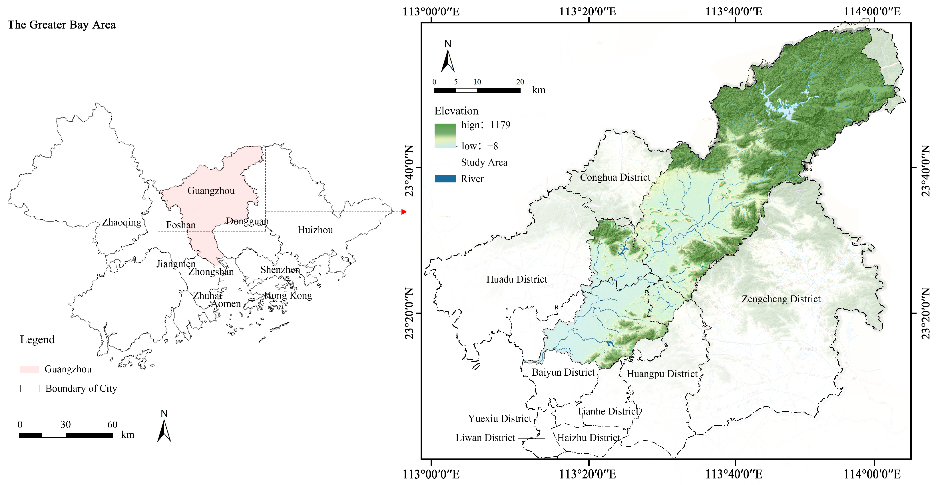
2.1. Study Area

The Liuxi River basin is located in the northern part of Guangzhou City (Figure 1). The main river has a total length of 157.04 km, covering a basin area of 2290 square kilometers with an average slope of 0.8%. The region within the Liuxi River basin experiences a subtropical climate, with a average annual temperature of 21.2 °C and a multi-year average annual rainfall of 1823.6 mm. Within the basin are important water source conservation areas and urban ecological corridors for Guangzhou. The mountainous forest ecosystems in the upper and middle reaches of the Liuxi River basin serve as crucial ecological source areas and ecological buffer zones for the city of Guangzhou [29]. In the central and upper reaches, areas like Huadu have adopted tourism development as a strategic approach to mitigate the impact of urban development on conservation areas and surrounding ecological functions [30]. The lower reaches of the basin have already been significantly affected by urban development, resulting in blurred boundaries between urban and rural areas.
Shaxi River is a primary tributary of the Liuxi River. It covers an area of 28.47 square kilometers and encompasses five administrative villages: Qiangang Village, Hongshi Village, Wenge Village, Yan Village, and Feige Village. These villages are further divided into 18 natural villages. Shaxi River is located in the northeastern part of Taiping Town, Huadu District, within the midstream of the Liuxi River basin. It flows from the northeast and converges with the Liuxi River towards the southwest. The Shaxi River basin is characterized by higher terrain on its periphery and lower terrain in the central region, forming a small basin known as Shaxi Tong. The settlements within Shaxi Tong have a long history, with the ancient village of Qiangang dating back to the Song and Yuan dynasties. Over an extended period of historical development, a landscape characterized by a combination of orchards and villages has gradually taken shape and is well preserved to this day.

2.2. Data Sources

This study utilizes two types of data: natural resource data and village historical data. Digital elevation, land cover, and land use data were sourced from open-source datasets, while data on landforms and slopes were classified from DEM data using ArcGIS software (10.2). Village historical data were extracted from multi-temporal remote sensing imagery to obtain points of interest (POI) data for settlements. Preliminary classification was performed through a combination of historical literature research, and it was verified using Google Earth satellite images and multiple field surveys. Land cover data, combined with Landsat satellite images and modified viewpoint POI data, were used to delineate the boundaries of rural land use patches (Table 1).

2.3. Research Methodology

This study integrates the LCA and HLC methods, and the identification process is divided into four stages: scale definition, pattern identification, feature description, and factor analysis, applied at two hierarchical scales: the basin and vernacular units (Figure 2). At the basin scale, the LCA approach is drawn upon to identify spatial heterogeneity in the basin regarding physical geography and residential culture. At the unit scale, the study draws on the HLC approach to identify the historical evolutionary characteristics of the landscape.

2.3.1. Step 1: Scale Definition

This study applies the scale theory of landscape ecology to define vernacular landscape patterns in three dimensions: temporal scope, spatial scope, and spatial grain [33]. The spatial scope includes settlement clusters, the natural landscapes associated with the settlements, and the agricultural landscapes derived from them, considered as an integrated whole. The temporal scope focuses on comparing landscape evolution across different social development stages. The definition of spatial grain is determined by factors such as the resolution of image data and the research objectives.

2.3.2. Step 2: Pattern Identification

  • Historical Background Evolution Analysis: Focusing on the “natural–agricultural–settlement” landscape systems, textual information is integrated to outline long-term historical evolution stages and characteristics. Some information can be visualized using the ArcGIS platform.
  • Type Definition and Partitioning: At the basin scale, pattern type classification follows the process of “overlay and pattern recognition—landscape unit division—landscape unit classification”, with boundaries defined by the types of units. At the unit scale, landscape types are classified based on factors such as historical origins and natural geography, with boundaries delineated by the patch boundaries of vernacular landscape elements.

2.3.3. Step 3: Feature Description

  • Landscape Pattern Feature Description: Landscape pattern indices can be used to quantify the spatial pattern (composition and configuration) of land cover features [34]. Each index carries unique ecological significance. The study used FRAGSTATS software (4.2) [35] to analyze changes in five landscape characteristics: area and edge, aggregation, shape, fragmentation, and diversity. At the basin scale, six metrics were selected, while at the vernacular unit scale, nine metrics were selected (Table 2).
  • Extraction of Core Pattern Characteristics: Combining desk-based research and field survey results, the core characteristics of various landscape types are described from four aspects: natural landscape, agricultural landscape, settlement landscape, and overall landscape pattern.

2.3.4. Step 4: Factor Analysis

Redundancy analysis (RDA) is an ordination method that combines regression analysis with principal component analysis. It analyzes the causes of changes in response variables by examining the correlations between response and explanatory variables, and extracts the main explanatory variables from the dataset [36]. In this study, Canoco 5.0 software was used. Seven variables were selected as response variables: Patch Area (CA), Mean Patch Area (AREA_MN), Mean Nearest Neighbor Distance (MNN_MN), Landscape level AREA_MN, and Shannon’s Diversity Index (SHDI). At the basin scale, driving factors were identified through a systematic literature review, while the unit scale analysis extends the investigation to socioeconomic determinants through in-depth exploration, building upon this foundation. Five explanatory variables were selected: average distance from settlements to water systems, average radius of farmland, average elevation, average relief, and average slope (Table 3). Redundancy analysis was performed using Canoco software (5.0).

3. Results

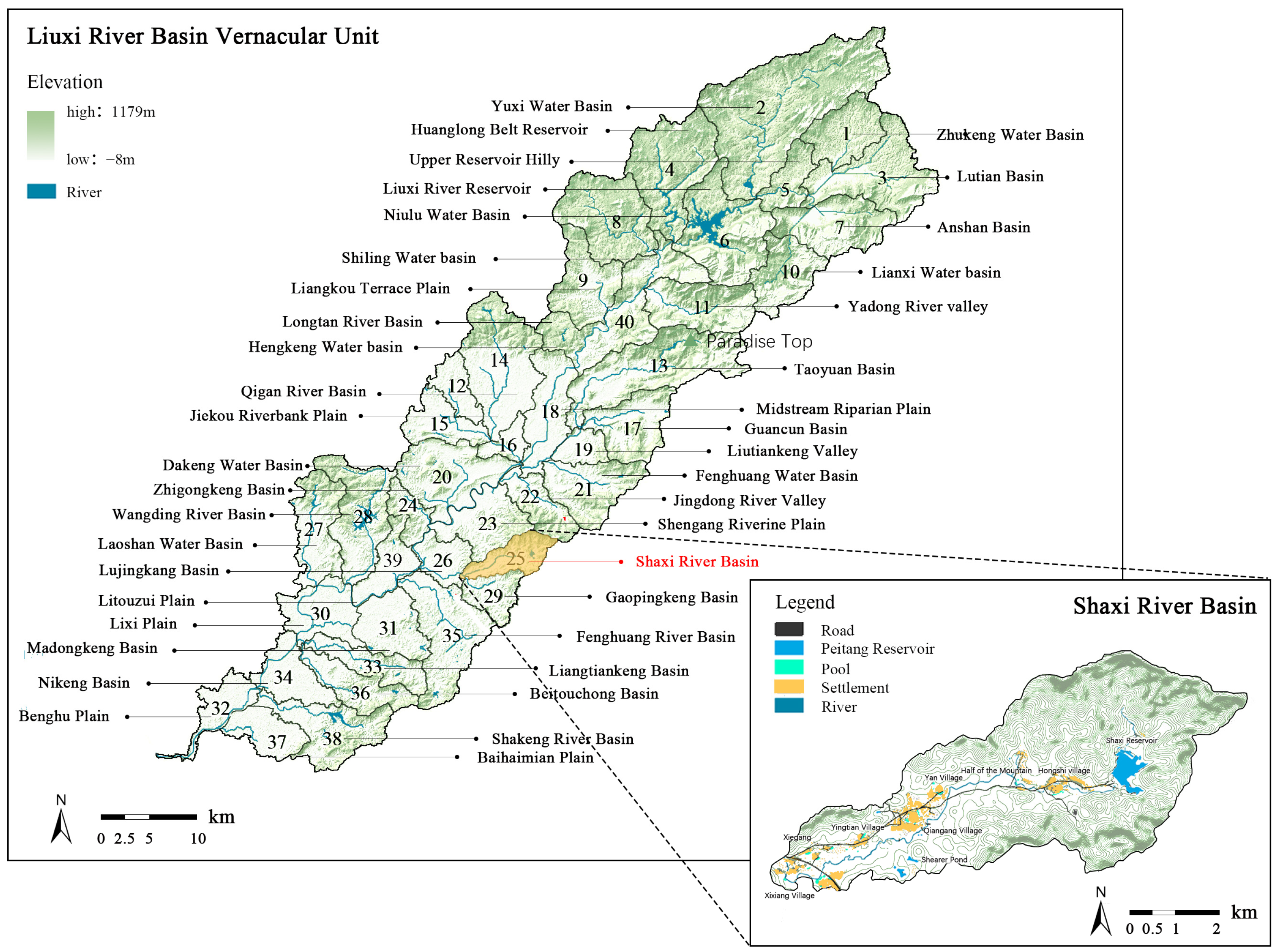
3.1. Definition of the “Basin–Vernacular Unit” Research Scale

In terms of spatial scope, based on the scale theory in Landscape Ecology and a current survey of the Liuxi River basin, the vernacular landscape patterns within the Liuxi River basin is divided into two spatial scale levels: the basin scale (100 to several thousand square kilometers) and the vernacular unit scale (10–100 square kilometers). Preliminary analysis shows that the settlement landscapes within the Liuxi River basin exhibit characteristics of clustered distribution along different geographic units. Basin boundaries were determined based on settlement characteristics and adjusted in conjunction with administrative boundaries and settlement locations. This resulted in the delineation of 40 vernacular units within the Liuxi River basin, each named according to geographical characteristics, river names, and other relevant factors (Figure 3).
In terms of the time frame, the basin scale research primarily focuses on spatial heterogeneity, and due to the challenges of data acquisition and corrections associated with a larger scale, it was limited to the year 1985, as it represents the earliest year for which higher-resolution remote sensing images are available. In contrast, the vernacular unit scale, due to its smaller scale and the feasibility of conducting comprehensive on-site surveys and interviews, was studied within the time range of 1974–2020, with a focus on the temporal evolution of the landscape patterns.
In terms of spatial precision, at the basin scale, historical remote sensing images with a 30-m resolution were used. At the unit scale, with a focus on the settlement’s main roads as linear landscapes in the vernacular landscape, the raster cells were set at 2.5 m.

3.2. Basin Scale Vernacular Landscape Pattern Characteristics

3.2.1. Historical Evolution of Vernacular Landscape

Initial settlement patterns in the Liuxi River basin demonstrate prehistoric clustering within major valley basins, while agricultural advancements precipitated transitional relocation to expansive alluvial plains. Since the Song and Yuan dynasties, a peak in migration led to the formation of settlement patterns in the Liuxi River basin, which included evenly distributed settlements on the riverbank plains, clustered settlements in tributary river valley basins, and dispersed settlements in the hilly and mountainous areas. This patterns gradually matured during the Qing dynasty. Considering data availability and accuracy, this study focuses on the settlement periods of fluvial plains, valley basins, and mountainous hills, dividing the historical evolution of vernacular landscapes in the Liuxi River basin into three phases: the Song-Yuan Origin Period, the Ming-Qing Formation Period, and the Modern Development Period.

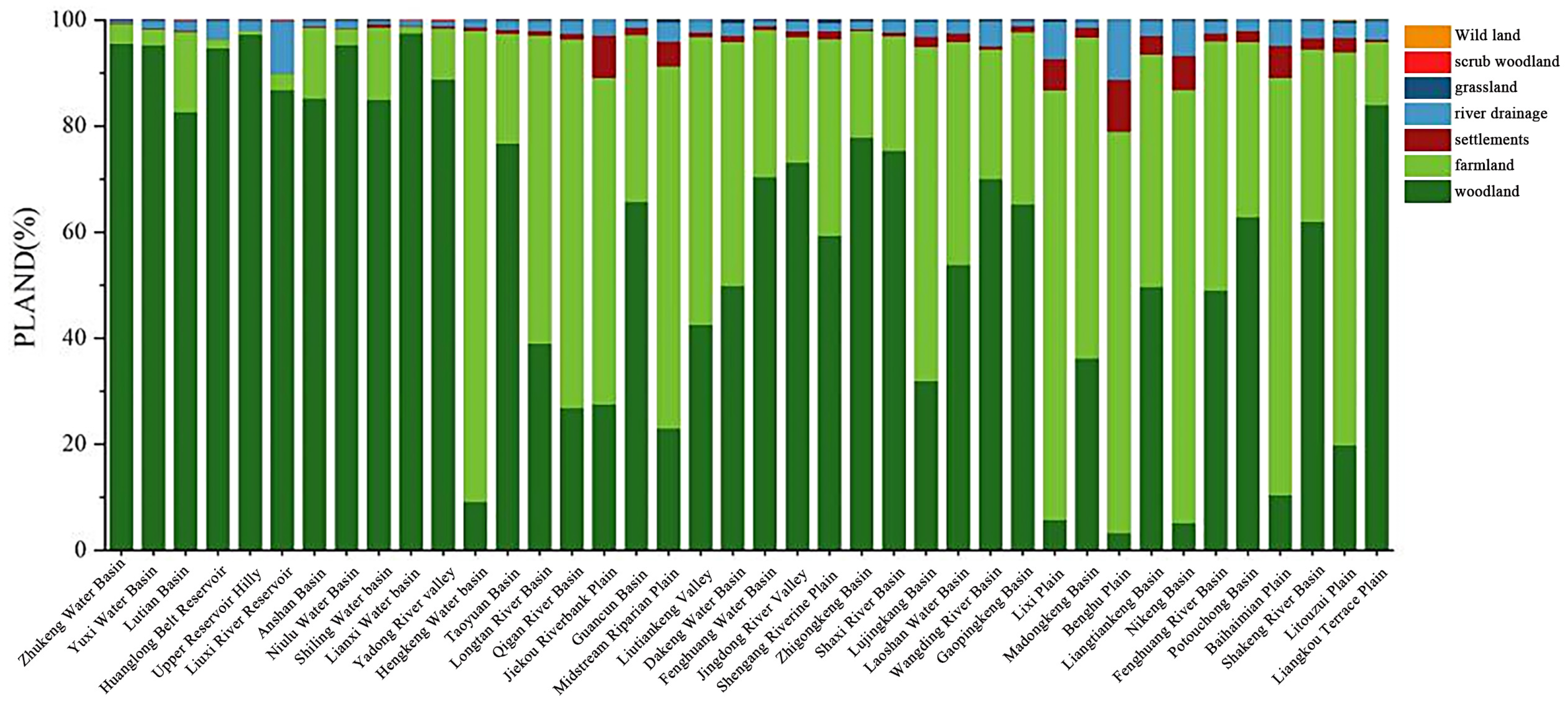
3.2.2. Identification of the Characteristics of Vernacular Landscape Patterns

The vernacular landscape types in the Liuxi River basin are classified into two levels. The first-level classification focuses on the natural characteristics of the landscape and includes eight types: woodland, shrubland, grassland, river systems, wild land, settlements, farmland, and agricultural water systems. The second-level classification focuses on the historical evolution of the landscape and includes 24 types. Using ArcGIS software, overlay analysis was performed on the data for the natural, settlement, and agricultural landscape systems to generate the 1985 vernacular landscape pattern map of the Liuxi River basin (Figure 4).

3.2.3. Description of the Characteristics of the Patterns of Vernacular Landscape

To quantitatively describe the spatial distribution differences of vernacular landscape patterns in different units, landscape pattern indices were used to quantify the structural and morphological characteristics of the landscape. Regarding patch area characteristics, the overall pattern shows a higher proportion of forest landscapes in the middle and upper reaches, while downstream, the proportion of forest area decreases, while the proportion of farmland and settlement areas increases, and the proportion of settlement area increases, showing clear spatial differences (Figure 5). In terms of settlement patch aggregation, the Liuxi River basin exhibits dispersed settlements in the river valley basins and dense settlements in the riverbank plains. The landscape fragmentation shows low fragmentation in the upstream and high fragmentation in the downstream. Vernacular units along the mainstream of the Liuxi River exhibit higher fragmentation compared to those along the tributaries. The SHDI in the upstream is lower than in the middle and lower reaches, with higher landscape diversity in the upstream. In contrast, Patch Richness (PR) in the downstream is generally lower than in the upstream, indicating that a higher degree of fragmentation in the downstream leads to greater diversity (Figure 6). Overall, the landscape pattern characteristics in the basin exhibited distinct differences between the upstream and downstream regions. The upstream landscapes had lower fragmentation, higher dominance of woodland landscapes, and lower landscape diversity, while the downstream landscapes were more fragmented with higher landscape diversity.
Based on the characteristic differences of each vernacular unit within the “natural–settlement–agriculture” landscape system and differences in landscape pattern composition, units sharing common pattern characteristics are grouped into categories. The 40 vernacular units are classified into 12 types. The classification criteria are as follows: (1) Natural landforms are the fundamental basis for landscape pattern differentiation and serve as the primary classification criterion. (2) Based on the analysis of the Percentage of Landscape (PLAND) in the basin, forests and farmland reflect the main features of landscape patterns, forming the secondary classification basis. (3) Settlements, as the core vernacular landscape, vary in spatial layout and characteristics among different ethnic groups, providing the tertiary classification basis. Based on the results of landscape pattern analysis, both quantitative and qualitative information were used to describe the 12 vernacular unit types and extract the core characteristics of vernacular landscape patterns (Table 4).

3.2.4. Factors Influencing Vernacular Unit Patterns Differentiation

Due to the clear upstream-downstream differentiation in the landscape pattern characteristics of the Liuxi River basin, RDA was applied to explore the impact of natural geographical factors such as topography and slope on the spatial differentiation of landscape patterns. The results indicate that four subsets of explanatory variables collectively explain 68.8% of the variation in landscape pattern indices, demonstrating a strong correlation between landscape pattern characteristics in the Liuxi River basin and topography, water systems, and agricultural factors. All five variables exhibit a significant relationship (p < 0.01). The average nearest distance from settlements to water systems explains the highest proportion of variation (46.3%). When combined with average elevation, these two factors together explain 82.77% of the variation in the response variable, indicating that they play a major role in influencing the landscape patterns of the Liuxi River basin (Table 5).

3.3. Unit Scale Vernacular Landscape Pattern Characteristics

3.3.1. Historical Evolution of Vernacular Landscape in the Shaxi River Unit

In the long-term historical dimension, the historical evolution of the Shaxi River unit follows the same trend as the broader basin scale. Located in the midstream low-elevation basin area of the Liuxi River basin, the Shaxi River unit saw an increase in settlements during the Song and Yuan dynasties. The earliest existing settlement in the unit, Qiangang Village, was established during this period, and throughout the Qing dynasty, settlements continued to migrate into the Shaxi River unit. The historical evolution of vernacular landscapes in the Shaxi River unit occurred in three stages: the period of native settlements of the Nanyue people, the period of integration between Han and local cultures, and the settlement period of the Cantonese and Hakka people. These stages correspond to the periods before the Song dynasty, from the Song to the Ming dynasties, and after the Qing dynasty, respectively.

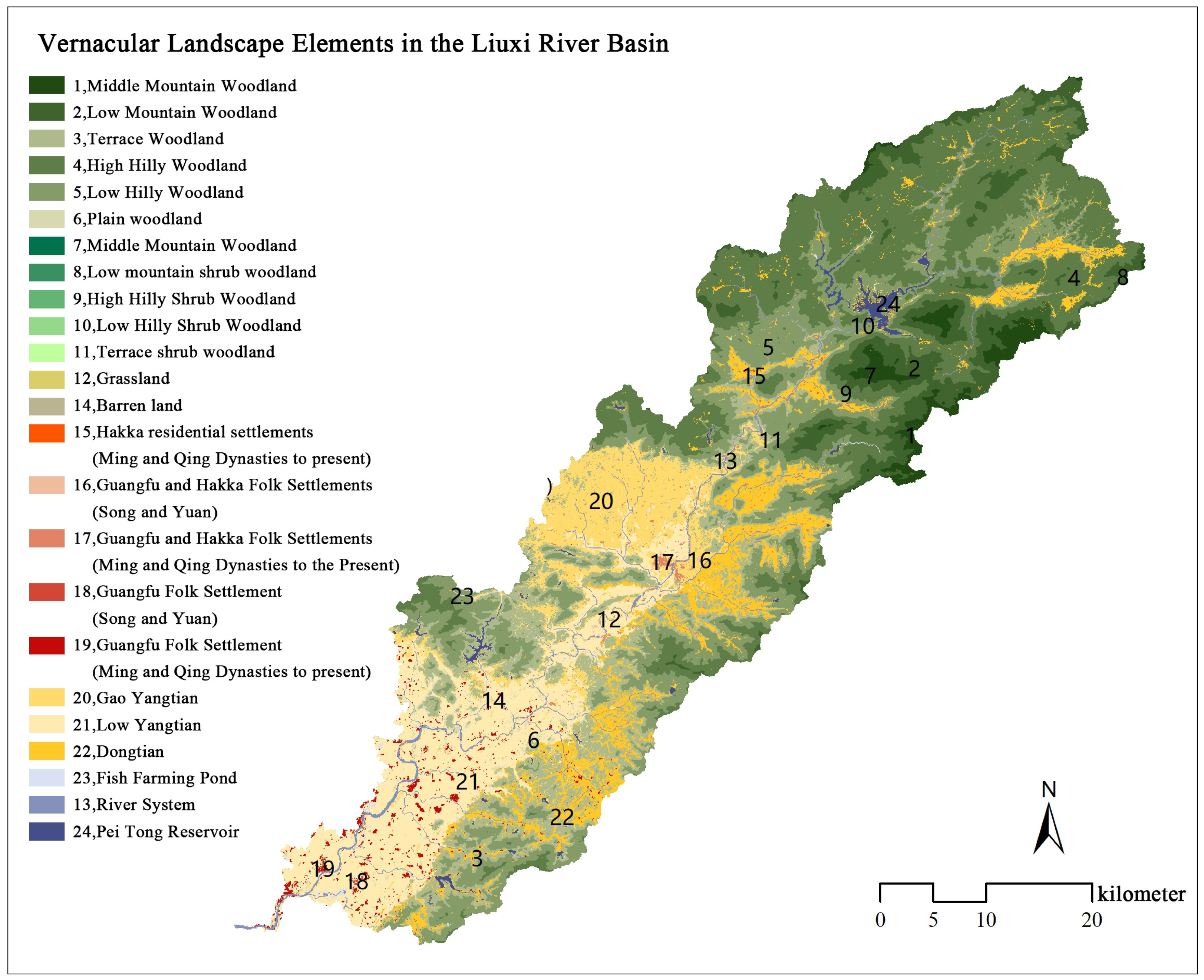
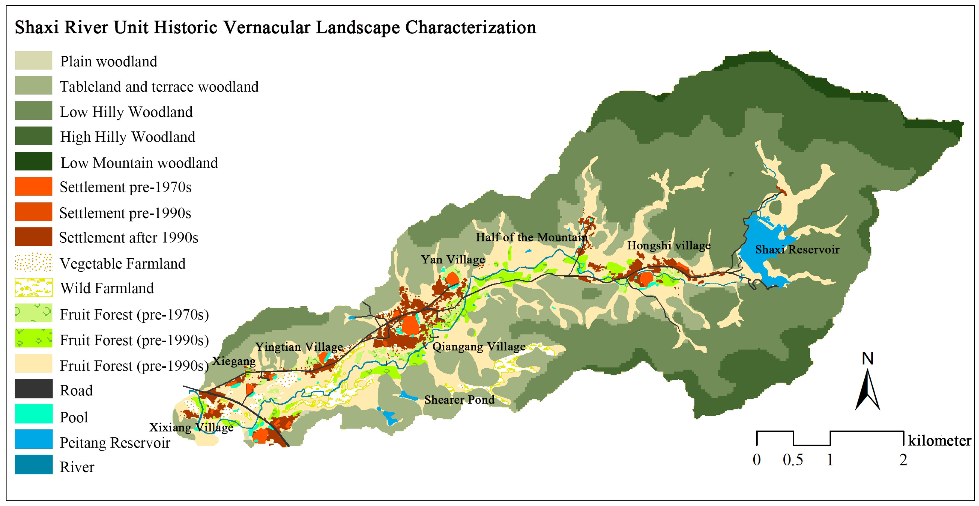
3.3.2. Identification of the Characteristics of Vernacular Landscape Patterns of the Shaxi River Unit

The vernacular landscape patterns in the Shaxi River unit are classified into two levels. The primary landscape types include forests, rivers, roads, settlements, ponds, orchards, reservoirs, terraces, and fields—eight in total. The secondary landscape types consist of low hilly woodland landscapes, high hilly woodland landscapes, and so on, totaling 15 classes. Using land cover data for various years in the Shaxi River unit and tracing its historical development context, vector overlay analysis was performed in ArcGIS. This classification of vernacular landscape types is based on the formation period, evolutionary processes, and agricultural landscape characteristics of specific vernacular landscape parcels. It results in 15 vernacular landscape pattern types and generates historical vernacular landscape characteristic maps (Figure 7).

3.3.3. Description of the Characteristics of Vernacular Landscape Patterns in the Shaxi River Unit

To quantify the changes in vernacular landscape patterns in the Shaxi River unit over the 46-year period from 1974 to 2020, this study used Fragstats software (4.2) to analyze the changes in landscape characteristics, including area, shape, fragmentation, and heterogeneity. Regarding landscape area characteristics, the shapes of landscape types in the Shaxi River unit have become more irregular, complex, and fragmented, with most farmland being converted into orchard landscapes (Table 6). In terms of landscape shape, both the Landscape Shape Index (LSI) and Edge Density (ED) have increased, indicating that the overall landscape has become more irregular and complex, formed by patch mosaics. In terms of landscape fragmentation, although fragmentation (Pi) increased between 1988 and 2020, suggesting greater overall fragmentation, the landscape Contagion Index (CONTAG) showed little change, and the dominant patch (forest) still maintained good connectivity. Regarding landscape diversity, the SHDI has gradually increased, reflecting greater landscape diversity, while the Shannon Evenness Index (SHEI) showed little change. This suggests that the increase in landscape heterogeneity is largely due to an increase in landscape richness, or the number of landscape types (Figure 8).
Based on the historical evolution of the vernacular landscape and the analysis of landscape pattern changes, descriptions of various vernacular landscape types in the Shaxi River unit are provided (Table 7).

3.3.4. Factors Influencing the Evolution of Vernacular Unit Patterns in the Shaxi River Unit

Natural geographical factors form the foundation for changes in landscape spatial patterns. Most settlements in the Shaxi River unit are located on foothills, slightly away from the river, with flat terraces and riverbank terraces designated as agricultural production areas. This defines the fundamental vernacular landscape patterns of the Shaxi River as the “80% mountain, 5% water, 5% field” structure. However, on a smaller scale, socio-economic factors influence the spatial differentiation of rural settlement patterns [37]. At the vernacular unit scale, three factors explain the landscape pattern changes in the Shaxi River unit:
  • Agricultural Land Transformation: The agricultural landscape in the unit shifted from food crops to cash crops, such as nurseries and orchards, leading to increased fragmentation and diversity in cropland landscapes, thus creating a multifunctional agricultural landscape.
  • Urbanization and Population Mobility: Industrial development during the urbanization process led to the migration of rural populations. As a result, agricultural land was left uncultivated, and these abandoned fields became irregularly scattered within the orchard and vegetable field landscapes.
  • Diminishing Vernacular Social Relationships: The lack of strong vernacular social relationships has led to the irregular distribution of newly constructed settlements. Villages established before the Ming and Qing dynasties followed a comb-like layout. However, newer settlements established after the 19th century tend to be located along major transportation corridors. Village residents construct houses on existing orchards or rice fields, resulting in settlements being distributed in a fragmented and scattered pattern.

4. Discussion

4.1. Methods for Character Recognition of Vernacular Landscape Patterns

This study systematically examines vernacular landscape pattern characteristics through a dual-scale analytical framework, integrating spatial heterogeneity at the basin level with temporal dynamics at the vernacular unit scale. While previous research on vernacular landscape character assessment has focused on provincial, municipal, district, and village scales, this study explores feature assessment at both the basin and vernacular unit scales, thus contributing to transitional research across scales. The study found that the LCA method is not completely effective at the Liuxi River basin because it first divides the area into grids and then uses clustering to determine the scope of landscape zones, which can disrupt the integrity of vernacular units. Therefore, delineating vernacular units based on basin boundaries and settlement characteristics ensures that settlements within the same unit share common features, thus preserving the integrity of the vernacular landscape pattern. Using the “basin–vernacular unit” hierarchy, the LCA method is applied at the basin scale to classify areas based on natural geographical factors, identifying regional differences. At the vernacular unit scale, the HLC method is employed, integrating historical information through field surveys and interviews to identify historical landscape characteristics. By combining these two methods, a vernacular landscape pattern feature identification system is proposed, consisting of scale definition, pattern identification, feature description, and factor analysis. This approach is significant for hilly and mountainous regions with complex and diverse terrains [38].

4.2. Landscape Management Recommendations

The research findings from two scales inform the establishment of a hierarchical “basin–vernacular unit” governance framework that bridges strategic planning with practical implementation. Regional authorities should implement differentiated zoning strategies based on upstream-downstream variations in landscape fragmentation, dominance, and diversity indices, prioritizing ecological conservation in upper reaches while fostering urban-rural integration through multifunctional landscape management in lower reaches. Concurrently, enhanced aquatic corridor management should integrate basin resources to strengthen the synergy between hydrological systems, settlements, and landscape matrices. Local administrations must control haphazard construction along major thoroughfares to preserve ecological sustainability and vernacular landscape features, while enhancing the perceptual quality of mountain-water landscape patterns. Agricultural landscapes should be optimized for multifunctional values encompassing production efficiency, visual aesthetics, and biodiversity conservation. Furthermore, developing clustered and compact settlement patterns requires reestablishing rural social networks to enhance community organizational capacity, ensuring public participation in village spatial planning processes.

4.3. Limitations and Future Research

This study demonstrates significant global application potential. It provides critical insights for rural areas characterized by hilly terrain interspersed with mountains, plateaus, and terraces, particularly those with rich cultural heritage. The data sources and analytical tools employed possess universal applicability, allowing researchers in other regions to maintain the core methodological framework while adapting region-specific classification parameters. However, there remains considerable potential for improvement in information integration and stakeholder engagement. In regions lacking historical documentation, the integration of oral history with Participatory Geographic Information Systems (PGIS) proves essential for historical landscape reconstruction. As the connotation of “landscape” continues to expand, future trends in landscape management are likely to be multifunctional. How to establish an assessment system for vernacular landscape pattern features aligned with this goal to guide landscape planning practices remains to be explored.

5. Conclusions

This study focused on the Liuxi River basin in Guangzhou, China, conducting a dual-scale analysis of vernacular landscape pattern characteristics at the “basin–vernacular unit” scale. Using a combination of qualitative and quantitative methods, this study analyzed the spatial heterogeneity and temporal evolution of the basin. The key findings include the following:
  • The Liuxi River basin experienced three main phases of development, resulting in three predominant settlement patterns: even distribution along the riverbanks, clustering in river valleys, and dispersion in hilly and mountainous areas;
  • In 1985, the landscape patterns of the Liuxi River basin exhibited distinct characteristics in terms of landscape fragmentation, dominance, and diversity between the upper and lower reaches. The analysis classified the units into 12 landscape types based on the heterogeneity of natural features, cropland, and settlements;
  • From the pre-Qin period to the present, the vernacular landscape evolution of the Shaxi River unit can be categorized into three stages, resulting in two main traditional settlement patterns: “forest-village-pond-field-river” and “forest-river-village-pond-field”;
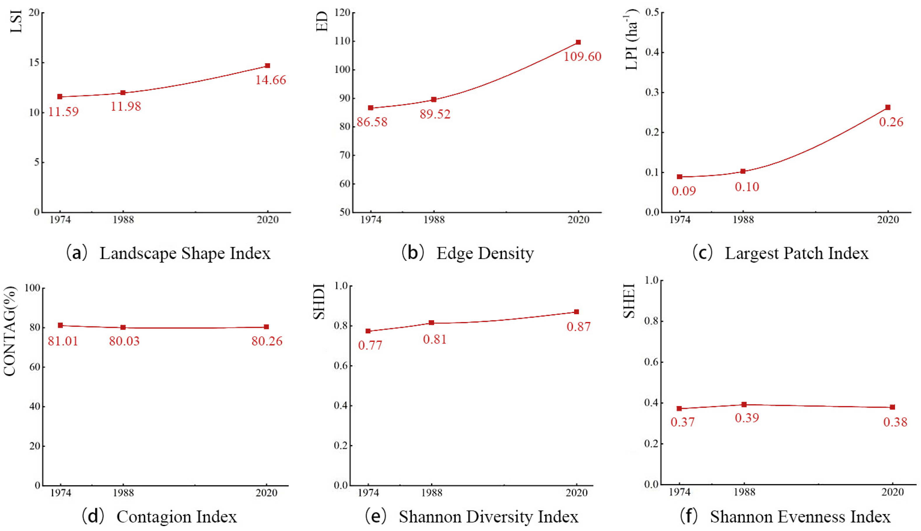
  • From 1974 to 2020, the landscape patterns of the Shaxi River unit tended toward fragmenting into irregular shapes and increased diversity.
Within the context of rural revitalization and ecological sustainability, the dual-scale approach provides guidance for constructing a “basin-unit” two-tier governance framework. At the basin scale, regional strategies emphasize macro-level coordination and interdepartmental collaboration. At the unit scale, localized initiatives focus on differentiated governance and place-specific characteristics. This methodological framework can be standardized through a “database–methodology toolkit–policy linkage” workflow, establishing a paradigmatic model for vernacular landscape governance in global rapidly urbanizing regions, with particular applicability to rural areas characterized by geographically complex terrain and culturally rich heritage endowments.

Author Contributions

Conceptualization, N.W.; methodology, N.W., Y.Z. and Z.L.; software, N.W., Y.Z. and Z.L.; validation, N.W., Y.Z. and Z.L.; formal analysis, Y.Z. and Z.L.; investigation, Y.Z. and Z.L.; resources, N.W.; data curation, Y.Z. and Z.L.; writing—original draft preparation, N.W., Y.Z. and Z.L.; writing—review and editing, N.W., Y.Z. and Z.L.; visualization, Y.Z. and Z.L.; supervision, N.W.; project administration, N.W.; funding acquisition, N.W. All authors have read and agreed to the published version of the manuscript.

Funding

This research was funded by the National Natural Science Foundation of China, grant number 52008172, and the Natural Science Foundation of Guangdong, China, grant number 2022A1515011678.

Data Availability Statement

Restrictions apply to the datasets. The datasets presented in this article are not readily available because this data is part of the ongoing new research. Requests to access the datasets should be directed to arwnx@scut.edu.cn.

Conflicts of Interest

The authors declare no conflicts of interest.

References

  1. Altaba, P.; García-Esparza, J.A.; Valentín, A. Assembling Cultural and Natural Values in Vernacular Landscapes: An Experimental Analysis. Remote Sens. 2022, 14, 4155. [Google Scholar] [CrossRef]
  2. Siddique, M.A.; Wang, Y.; Xu, N.H.; Ullah, N.; Zeng, P. The Spatiotemporal Implications of Urbanization for Urban Heat Islands in Beijing: A Predictive Approach Based on CA-Markov Modeling (2004–2050). Remote Sens. 2021, 13, 4697. [Google Scholar] [CrossRef]
  3. Liu, X.; He, J.T.; Xiong, K.; Liu, S.; He, B.J. Identification of factors affecting public willingness to pay for heat mitigation and adaptation: Evidence from Guangzhou, China. Urban Climate 2023, 48, 19. [Google Scholar] [CrossRef]
  4. Liu, B.; Chen, P. Evaluation and optimization of rural landscape features based on the science of human settlements. J. Chin. Urban 2020, 18, 1–8. [Google Scholar]
  5. Wang, X. RETRACTED: The practice teaching of regional cultural expression in rural landscape planning and design under the background of urban–rural integration. Int. J. Electr. Eng. Educ. 2023, 60, 3625–3641. [Google Scholar] [CrossRef]
  6. The State Council of the People’s Republic of China. Opinions of the CPC Central Committee and the State Council on the Implementation of the Rural Revitalization Strategy. Available online: https://www.gov.cn/gongbao/content/2018/content_5266232.htm (accessed on 1 April 2025).
  7. The State Council of the People’s Republic of China. Instructions on Comprehensively Promoting Rural Revitalization and Accelerating Agricultural and Rural Modernization. Available online: http://www.gov.cn/zhengce/2021-02/21/content_5588098.htm (accessed on 1 April 2025).
  8. The State Council of the People’s Republic of China. Opinions of the Central Committee of the Communist Party of China and the State Council on Learning from and Applying the Experiences of the ‘Thousand Villages Demonstration, Ten Thousand Villages Renovation’ Project to Effectively Promote Comprehensive Rural Revitalization. Available online: https://www.gov.cn/zhengce/202402/content_6929934.htm (accessed on 1 April 2025).
  9. Xu, H.; Zhang, T.; Ge, B.; Song, Y. Developing of rural settlement landscape gene research system based on content analysis. J. Asian Archit. Build. Eng. 2023, 22, 2839–2850. [Google Scholar] [CrossRef]
  10. Li, Y.; Zhou, Y.; Cai, R.; Wang, C.; Wu, X. Chinese Rural Landscapes at Multiple Scales: Typologies and Diversity. Int. J. Environ. Res. 2024, 18, 42. [Google Scholar] [CrossRef]
  11. Jackson, J.B. Discovering the Vernacular Landscape; Yale University Press: New Haven, CT, USA, 1984. [Google Scholar]
  12. Andaroodi, E.; Sahrakaran, B. Vernacular Cultural Landscape of Qazvin’s Traditional Gardens: A Review of Basic Conepts and Analysis of Elements and Features within the Scope of Built Environment. Bagh-E Nazar 2017, 14, 39–48. [Google Scholar]
  13. Swanwick, C. Landscape Character Assessment. Guidance for England and Scotland; The Countryside Agency: Cheltenham, UK, 2002.
  14. Brown, S.; Youbo, Z. Landscape Planning in New Zealand. Chin. Landsc. Archit. 2013, 29, 12–17. [Google Scholar]
  15. Ziting, B.; Jianyun, Z. The Practice and Experience of Landscape Character Assessment in Hong Kong. Chin. Landsc. Archit. 2015, 31, 100–104. [Google Scholar]
  16. Clark, J.; Fairclough, G.; Darlington, J. Using Historic Landscape Characterization; English Heritage; Lancashire County Council: Preston, UK, 2004.
  17. England, H. Historic Landscape Characterisation. Available online: https://historicengland.org.uk/research/methods/characterisation/historic-landscape-characterisation/ (accessed on 1 April 2025).
  18. Fairclough, G.; Herring, P. Lens, mirror, window: Interactions between Historic Landscape Characterisation and Landscape Character Assessment. Landsc. Res. 2016, 41, 186–198. [Google Scholar] [CrossRef]
  19. Brown, G.; Brabyn, L. The extrapolation of social landscape values to a national level in New Zealand using landscape character classification. Appl. Geogr. 2012, 35, 84–94. [Google Scholar] [CrossRef]
  20. Griffiths, G. Transferring landscape character assessment from the UK to the Eastern Mediterranean: Challenges and perspectives. Land 2018, 7, 36. [Google Scholar] [CrossRef]
  21. Jellema, A.; Stobbelaar, D.-J.; Groot, J.C.; Rossing, W.A. Landscape character assessment using region growing techniques in geographical information systems. J. Environ. Manag. 2009, 90, S161–S174. [Google Scholar] [CrossRef]
  22. Gkoltsiou, A.; Paraskevopoulou, A. Landscape character assessment, perception surveys of stakeholders and SWOT analysis: A holistic approach to historical public park management. J. Outdoor Recreat. Tour. 2021, 35, 100418. [Google Scholar] [CrossRef]
  23. Wu, Y.; Wang, H.; Zhang, B. Landscape Character Diversity and Zoning Management: Case of Wuhan Metropolitan Area. J. Urban Plan. Dev. 2021, 147, 04020062. [Google Scholar] [CrossRef]
  24. Pan, Y.; Wu, Y.; Xu, X.; Zhang, B.; Li, W. Identifying terrestrial landscape character types in China. Land 2022, 11, 1014. [Google Scholar] [CrossRef]
  25. Wang, Y. From fragments to system: A research on the mesoscale structure of vernacular landscapes in the Hang-Jia-Hu area, China. J. Asian Archit. Build. Eng. 2024, 1–20. [Google Scholar] [CrossRef]
  26. Li, G. Identification of Landscape Characteristics for Traditional Settlements in the Wuling Mountain Area Base on Integrated Protection. Ph.D. Thesis, Huazhong Agricultural University, Wuhan, China, 2017. [Google Scholar]
  27. Wang, N.; Lu, Q. Study on Traditional Rural Village’s Protection and Development Based on the Concept of Landscape Gene. South Archit. 2017, 3, 58–63. [Google Scholar]
  28. Xuan, G.; Yanyu, C. Historic England Area Assessment Methodology. Urban Plan. Int. 2019, 34, 155–158. [Google Scholar]
  29. Li, X.; Xiao, J.; Wang, J.; Wu, J.; Long, N. Research on the Asset Valuation and Application of Natural Resources assets for Ecological Restoration: A case study of Guangzhou City. Acta Ecol. Sin. 2022, 42, 1192–1202. [Google Scholar]
  30. The People’s Government of Conghua District, Guangzhou Municipality. Circular on the Issuance of the Outline of the Fourteenth Five-Year Plan for the National Economic and Social Development of Conghua District, Guangzhou City and the Visionary Goals for 2035. Available online: https://www.gz.gov.cn/zt/jjsswgh/qjgh/content/post_7618501.html (accessed on 1 April 2025).
  31. Yang, J.; Huang, X. The 30 m annual land cover dataset and its dynamics in China from 1990 to 2019. Earth Syst. Sci. Data 2021, 13, 3907–3925. [Google Scholar] [CrossRef]
  32. Feng, Z. Researching of traditional villages and houses of Guangzhou area basing on the cultural geography. Master’s Thesis, South China University of Technology, Guangzhou, China, 2014. (In Chinese). [Google Scholar]
  33. Chen, L.; Lu, Y.; Fu, B.; Wei, W. A framework on landscape pattern analysis and scale change by using pattern recognition approach. Acta Ecol. Sin. 2006, 26, 663–670. (In Chinese) [Google Scholar]
  34. Long, J.; Nelson, T.; Wulder, M. Regionalization of Landscape Pattern Indices Using Multivariate Cluster Analysis. Environ. Manag. 2010, 46, 134–142. [Google Scholar] [CrossRef]
  35. Davis, J.C.; Sampson, R.J. Statistics and Data Analysis in Geology; Wiley: New York, NY, USA, 1986; Volume 646. [Google Scholar]
  36. Li, G.; Jiang, C.; Du, J.; Jia, Y.; Bai, J. Spatial differentiation characteristics of internal ecological land structure in rural settlements and its response to natural and socio-economic conditions in the Central Plains, China. Sci. Total Environ. 2020, 709, 135932. [Google Scholar] [CrossRef]
  37. Guoping, R.; Liming, L.; Yonghu, F.; Chengcheng, Y.; Zhijun, S. Analysis of characteristic and influencing factors of rural settlement landscape pattern in metropolitan suburbs. Trans. Chin. Soc. Agric. Eng. 2016, 32, 220–229. (In Chinese) [Google Scholar]
  38. Boven, K.; Morohashi, J. Best Practices Using Indigenous Knowledge; Nuffic: The Hague, The Netherlands, 2002. [Google Scholar]
Figure 1. Map of the extent of the Liuxi River basin.
Land 14 00964 g001
Figure 2. Identification process for vernacular landscape pattern.
Land 14 00964 g002
Figure 3. Liuxi River basin vernacular units delineation.
Land 14 00964 g003
Figure 4. Vernacular landscape patterns in the Liuxi River basin (1985).
Land 14 00964 g004
Figure 5. Proportion of area for each landscape type in the vernacular unit.
Land 14 00964 g005
Figure 6. Spatial distribution of landscape aggregation characteristics, fragmentation, and diversity values.
Land 14 00964 g006
Figure 7. The 2020 Historic vernacular landscape patterns in the Shaxi River unit.
Land 14 00964 g007
Figure 8. Calculations of landscape shape, fragmentation, and diversity characteristics (af).
Land 14 00964 g008
Table 1. Table of data sources for the study.
Data TypeSource DateData NameSourceSpecificationAccuracy
Soil1978–1984Second National Soil Survey DataNational Earth System Science Data Center, China.shp1:1,000,000
Slope2006–2011ALOS Satellite DEM DataEuropean Space Agency.tiff12.5 m
Landform
River System2006–2011ALOS Satellite DEM DataEuropean Space Agency.tiff12.5 m
2018“Liuxi River Basin Scope Map”Guangzhou Water Bureau.jpg-
Land Use19851985 Land Cover DataYang, 2021 [31].tiff30 m
19741974 Keyhole Satellite ImageryUnited States Geological Survey.tiff2.3 m
19881988 SPOT-1 Satellite ImageryEuropean Space Agency.tiff20 m
-Multi-year Google Earth Satellite ImagesGoogle earth.jpg-
Placement of Settlements2020POIs for SettlementsGaode Map (Chinese website).shp-
1870–1871“Illustrated Guangdong”librarytext-
–2015“Villages of Guangdong: A Comprehensive Overview”
1535–1822“General Gazetteer of Guangdong”
1730, 1930“Chronicle of Conghua County”
2014Cultural Zoning of SettlementsFeng, 2014 [32].jpg-
Table 2. Indicators describing vernacular landscape pattern.
CharacteristicMetricDescriptionRange
Area and Edge MetricsPatch Area (CA) 1,2CA equals the sum of the areas of all patches of the corresponding patch type.CA > 0
Percentage of Landscape
(PLAND) 1,2
PLAND equals the percentage the landscape comprised of the corresponding patch type.0 < PLAND ≦ 100
Edge Density (ED) 2ED reflects the complexity of patch edges.ED ≥ 0
Aggregation MetricsMean Nearest Neighbor Distance (MNN_MN) 1MNN_MN indicates the mean shortest distance between patches.MNN_MN ≥ 0
Shape MetricsLandscape Shape Index (LSI) 2LSI reflects the degree to which patch shapes deviate from a rectangular shape.LSI ≥ 1
Fragmentation MetricsMean Patch Area (AREA_MN) 1,2AREA_MN reflects the average size of land-use types including settlements and farmland within different vernacular landscape units.AREA_MN ≥ 0
Largest Patch Index (LPI) 2LPI equals the percent of the landscape that the largest patch comprises.0 < LPI ≦ 100
Contagion Index (CONTAG) 1,2CONTAG reflects the connectivity and spread of dominant landscape types.0 < CONTAG ≦ 100
Diversity MetricsShannon’s Diversity Index (SHDI) 1,2SHDI reflects landscape heterogeneity.SHDI ≥ 0
Shannon’s Evenness Index (SHEI) 2SHEI reflects the distribution uniformity among different landscape type patches.0 ≦ SHEI ≦ 1
Patch Richness (PR) 1PR equals the number of different patch types present within the landscape boundary.PR ≥ 1
Note: 1 is the metric used at the basin scale, and 2 is the metric used at the unit scale.
Table 3. Factors influencing the pattern of vernacular landscape.
Influencing FactorType of VariableDescription of the Calculation Method
Topographical FactorsTerrain undulationContinuous VariablesThe terrain undulation reflects the topographic variation characteristics of the region.
ElevationHierarchical VariablesThe elevation was calculated using DEM data.
SlopeHierarchical VariablesThe slope was calculated using DEM data.
Hydrological FactorsAverage Distance from Settlements to Water SystemsContinuous VariablesA multi-ring buffer analysis was conducted for hydrological features (e.g., rivers, reservoirs, and ponds) by generating concentric buffer zones at radii of 0.1 km, 0.3 km, 0.5 km, 0.7 km, 1 km, and 3 km along the water systems. The number of settlements within each water system buffer zone is then summarized.
Agricultural FactorsCropland RadiusHierarchical VariablesThe cultivation radius was determined using a buffer analysis method, in which concentric buffers were incrementally expanded outward from settlements until the buffer area equaled the total cultivated land area. The corresponding buffer radius at this threshold was defined as the cultivation radius.
Table 4. Characterization of the vernacular landscape in the Liuxi River basin.
Serial No.Vernacular Unit TypeVernacular UnitNatural Landscape System CharacterizationSettlement Landscape System CharacterizationAgricultural Landscape System CharacterizationVernacular Landscape Pattern
Landform FeatureAverage ElevationConcentration of SettlementMean Distance From Settlement to Water SystemCultural-ethnic settlement clusterAgricultural LandscapeWater Conservancy-
1River Plain-Field-Guangfu and Hakka Settlement Landscape26River Plain33.7 m33.7 m260.8 mGuangfu, HakkaLow Yangtian 2,
High Yangtian 3
Installation of barrages along the main stem of the Liuxi River and the use of irrigation canals to channel irrigation30% mountains 5% water 60% fields
2River Plain-Field-Guangfu Settlement Landscape27
30
32
34
37
39
River Valley Basin−2.3–86.2 m74.2–91.6 m301.7–398.4 mGuangfuLow
Yangtian, High
Yangtian
Installation of barrages along the main stem of the Liuxi River and the use of irrigation canals to channel irrigation80% fields 10% mountains 10% water, 60% field 30% mountain 10% water, 50% mountain 5% water 45% field
3River Valley Basin—Forest Field—Hakka Settlement Landscape3
7
11
River Valley Basin318.0–466.3 m74.2–89.2 m115.7–161.2 mHakkaDongtian 4Reservoir, irrigation canal75% mountain 5% water 20% field
4River Valley Basin-Forest Field-Guangfu and Hakka Intermixed Settlement Landscape13
21
22
25
River Valley Basin148.1–300.7 m74.2–91.6 m154–238 mGuangfu, HakkaDongtianReservoir, irrigation canal80% mountain 5% water 5% field
5River Valley Basin—Field—Guangfu Settlement Landscape29River Valley Basin75.6 m77.2 m198.9 mGuangfuDongtian-50% mountain 50% field 5% water
6River Valley Basin-Field-Guangfu and Hakka Intermixed Settlement Landscape17
19
River Valley Basin64.7–143.7 m83.7–94.2 m199.5–207.0 mGuangfu, HakkaDongtianReservoir, irrigation canal50% mountain 50% field 5% water
7Terrace Plain—Forest Field—Guangfu Settlement Landscape28Tableland Plain106.8 m93.1 m188.7 mGuangfuYangtian 1Reservoir, irrigation canal70% mountain 5% water 25% field
8Terrace Plain—Forest Field—Guangfu and Hakka Intermixed Settlement Landscape24
40
Tableland Plain72.8–225.1 m0.3–0.5 m130.0–161.7 mGuangfu, HakkaDongtianReservoir, irrigation canal80% mountain 5% water 5% field
9Terrace Plain—Field—Guangfu and Hakka Intermixed Settlement Landscape12
14
15
16
18
20
23
Tableland Plain40.8–126.0 m81.9–133.6 m157.9–331.3 mGuangfu, HakkaYangtian, Dongtian-25% mountain 70% field 5% water, 10% mountain 10% water 80% field, 50% mountain 5% water 45% field, 80% field 10% mountain 10% water
10Terrace Plain—Field—Guangfu Settlement Landscape31
33
35
36
38
Tableland Plain34.5–86.3 m40.8–126.0 m81.9–133.6 mGuangfuYangtian,
Dongtian
Reservoir60% mountain 5% water 35% field, 50% mountain 5% water 45% field
11Hilly Mountainou—Forested Field—Hakka Settlement Landscape1
2
5
8
9
10
Hilly Country179.90–396.4 m59.9–84.6 m84.9–132.9 mHakkaDongtian-95% mountain 5% field, and water, 80% mountain 5% water, 5% field
12Hilly Mountain-Woodland-Reservoir Landscape4
6
Hilly Country336.9–408.6 m66.7–70.7 m168.2–169.8 mHakkaDongtianReservoir95% mountain 5% field, and water, 80% mountain 5% water, 5% field
Note: 1 Yangtian refers to farmland distributed in the plains of the middle and lower reaches of rivers, with 2 Low Yangtian situated on floodplains and 3 High Yangtian located on terraces. 4 Dongtian denotes farmland distributed in mountain valleys, basins, or small river basins.
Table 5. Level of explanation and significance test for each explanatory variable.
Explanatory VariableExplains %Contribution %Pseudo-FSignificance Test p
Average Distance from Settlements to Water Systems57.78451.90.002
Average Elevation8.812.89.70.002
Average Undulation0.81.10.80.384
Average Slope 11.41.10.292
Average Cropland Radius0.50.70.50.596
Note: p < 0.01 is highly significant.
Table 6. PLAND and the annual rate of change in area.
Land Cover TypePLAND (%)Annual Rate of Change in Area (%)
1974198820201974–19881988–20201974–2020
Woodland72.6572.5772.66−0.550.300.04
Fruit Forest1.332.8519.8210.9053.0340.21
Settlement0.690.713.280.108.025.61
Deserted Settlement0.000.000.220.000.680.47
Road0.290.290.41−0.010.380.26
Farmland23.1321.600.63−10.89−65.53−48.90
Wild Farmland0.000.001.280.003.992.78
Reservoir and Pond0.610.751.300.951.721.49
Pool0.240.260.170.11−0.27−0.15
River1.070.980.24−0.61−2.32−1.80
Table 7. Shaxi River unit vernacular landscape characterization.
Vernacular Landscape SystemLevel 1 Landscape TypeLevel 2 Landscape TypeFeature Description
Natural Landscape SystemWoodlandLow Mountain Woodland LandscapeThis type is distributed in the northeastern portion of the Shaxi River Unit, constitutes the highest elevation area within the entire unit, and is less affected by human settlements.
High Hilly Woodland LandscapeThis type is distributed in the upper, northeastern, and southeastern portions of the Shaxi River, serving as the landscape context of the Shaxi Reservoir area. The vegetation exhibits intact conditions with a high degree of naturalness and minimal human influence.
Low Hilly Woodland LandscapeThis type is distributed in the middle and upper reaches of the Shaxi River, where economic forests are planted, and is the backdrop for the middle and upper reaches of villages such as Hongshi and Mianbiao. The vegetation is in good condition.
Terrace Woodland LandscapeThis type is distributed along the north and south fringes of the Shaxi River unit, surrounding settlements that are nestled against mountain forests and planted with commercial plantations.
Settlement Landscape SystemRoadRoadRedstone Shaxi Street has been the main road in Shaxi Pangyang since ancient times and is about 7 m. The road inside the village is 3.5–5 m. There are mostly residential houses on both sides of the main road.
SettlementLandscape of Guangfu Residential Settlement (Before 1970s)The traditional settlement area was laid out in a comb style, but it has been gradually deserted as the residents moved out one by one, with wild plants spreading and some residents planting vegetables and fruit trees on it.
Landscape of Guangfu Residential Settlement (1970s–1990s)There are fewer new settlements, and generally, new ones are built along the original settlement pattern or on the same site.
Landscape of Guangfu Residential Settlement (After 1990s)Newly built on the basis of the original settlement pattern, or distributed in an unorganized manner around the outside of the old settlement area. The layout is chaotic, distributed along the roads or sporadically distributed in the lychee fruit forests. There are no uniform rules for building height and orientation.
Hakka Residential Settlement (after 1980s)Traditional Hakka residential settlements no longer exist. Most of the original Hakka settlements were located in the forested areas upstream of the Shaxi Reservoir, but after the construction of the Shaxi Reservoir in 1958, they were moved downstream of the reservoir to the area of Hongshi Village.
PoolPoolIn front of traditional settlements of the Qing Dynasty and before, there were usually one or more ponds, commonly known as “fengshui ponds”. Such ponds are mostly artificial vertical barges, with an area of 0.2-0.5 hectares. In addition, there are small ponds sporadically distributed among farmland, fruit, and forest land.
Agricultural Landscape SystemFarmlandFarmland (vegetable beds)The farmland patches are small in size, embedded in fruit and forest land, mostly planted with vegetables for the villagers’ daily self-sufficiency.
Wild FarmlandIt is mainly found in the flat farmland areas along the lower riverbanks. Wild herbaceous plants with low scrub grow in abandoned farmland. Accessibility is low. Mostly rice fields until the 1990s.
Fruit ForestFruit Forest
(prior to the 1970s)
Fruit forests are the main agricultural landscape in the Shaxi River Unit. Fruit tree species include lychee, longan, and white olive, among which lychee has the largest planting area. Usually, the undergrowth of the fruit forests is sparse, and before the 1970s, the fruit forests were mainly located in areas around the villages where it was not suitable to grow food crops, but later on, due to the expansion of the settlements, most of the fruit forests were deforested. Now there is only sporadic distribution. Some of the older lychee trees have been transformed into a public space for village activities.
Fruit Forest
(1970s–1990s)
Small areas of fruit groves planted along the river were added between the 1970s and 1990s. After the 1990s, extensive planting of lychee began. There is little difference between the two in terms of visual perception.
Fruit Forest
(1990s onwards)
Agricultural Water SystemAgricultural Water SystemReservoir and PondShaxi Reservoir is the only reservoir in the Shaxi River unit, with an area of about 31.5 hectares, built in 1958. In the low-lying area of the southern terrace of Shaxi River, there are mountain ponds, which the villagers call ‘Jiaojian Pond’.
Disclaimer/Publisher’s Note: The statements, opinions and data contained in all publications are solely those of the individual author(s) and contributor(s) and not of MDPI and/or the editor(s). MDPI and/or the editor(s) disclaim responsibility for any injury to people or property resulting from any ideas, methods, instructions or products referred to in the content.

