
Spatiotemporal Dynamics and Simulation of Landscape Ecological Risk and Ecological Zoning Under the Construction of Free Trade Pilot Zones: A Case Study of Hainan Island, China

 , ,
, ,
Abstract
1. Introduction
2. Materials and Methods
2.1. Study Area
2.2. Data Sources
2.3. Methods
2.3.1. LER Model
- (1)
- LER assessment unit
- (2)
- LER index (LERI) construction
2.3.2. Future LULCC Under the PLUS Model
2.3.3. Ecological Risk Zoning and Management
2.3.4. Optimal Parameter Geographical Detector
3. Results
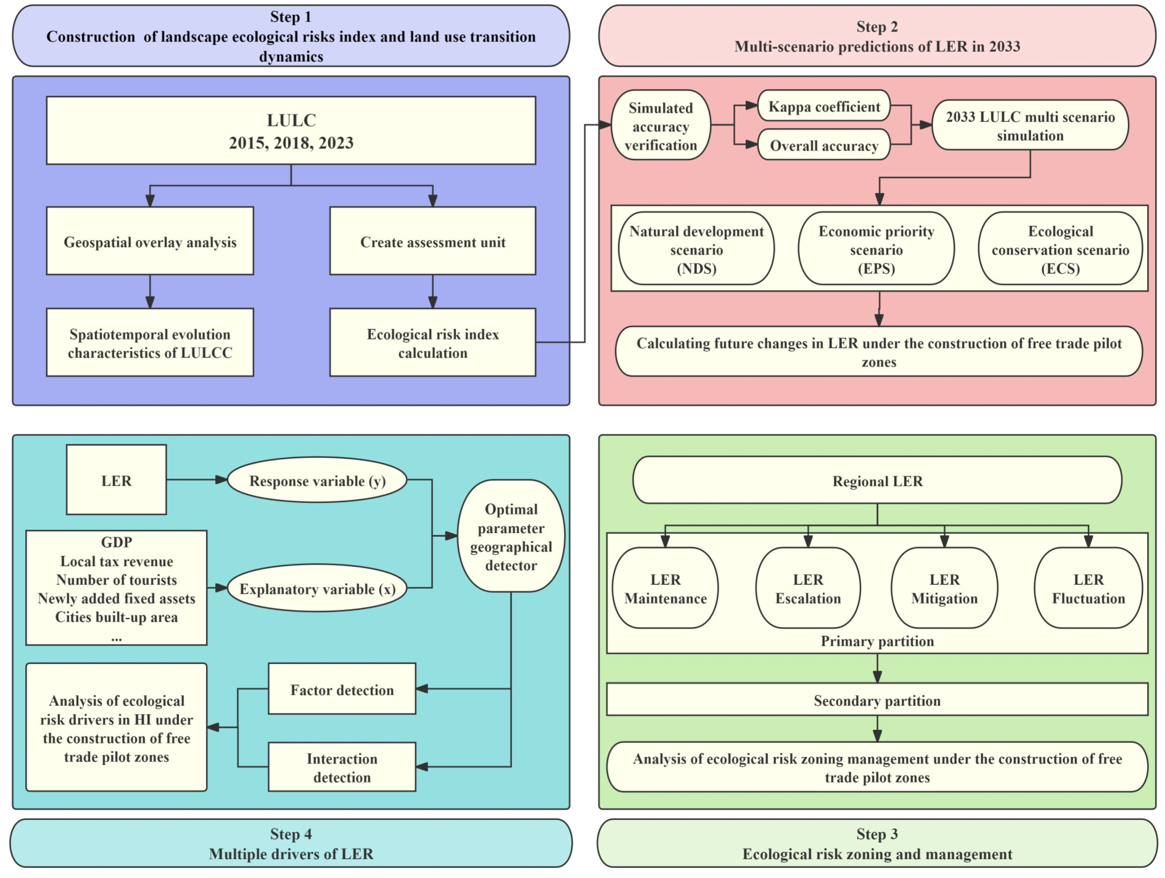
3.1. Spatiotemporal Evolution Analysis and Simulation of Landscape Patterns Before and After HPFTZ Development
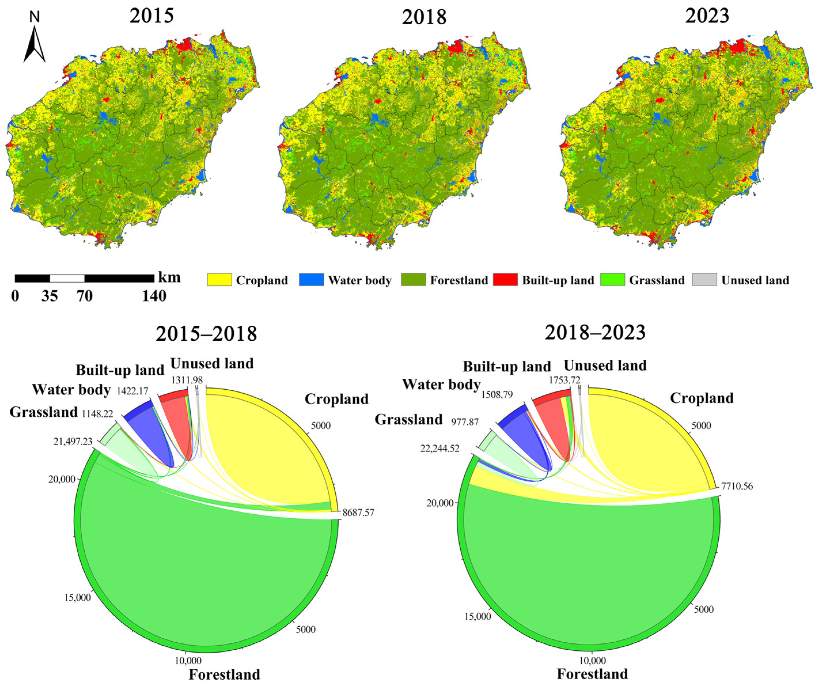
3.1.1. Spatiotemporal Evolution Characteristics of LULCC from 2015 to 2023
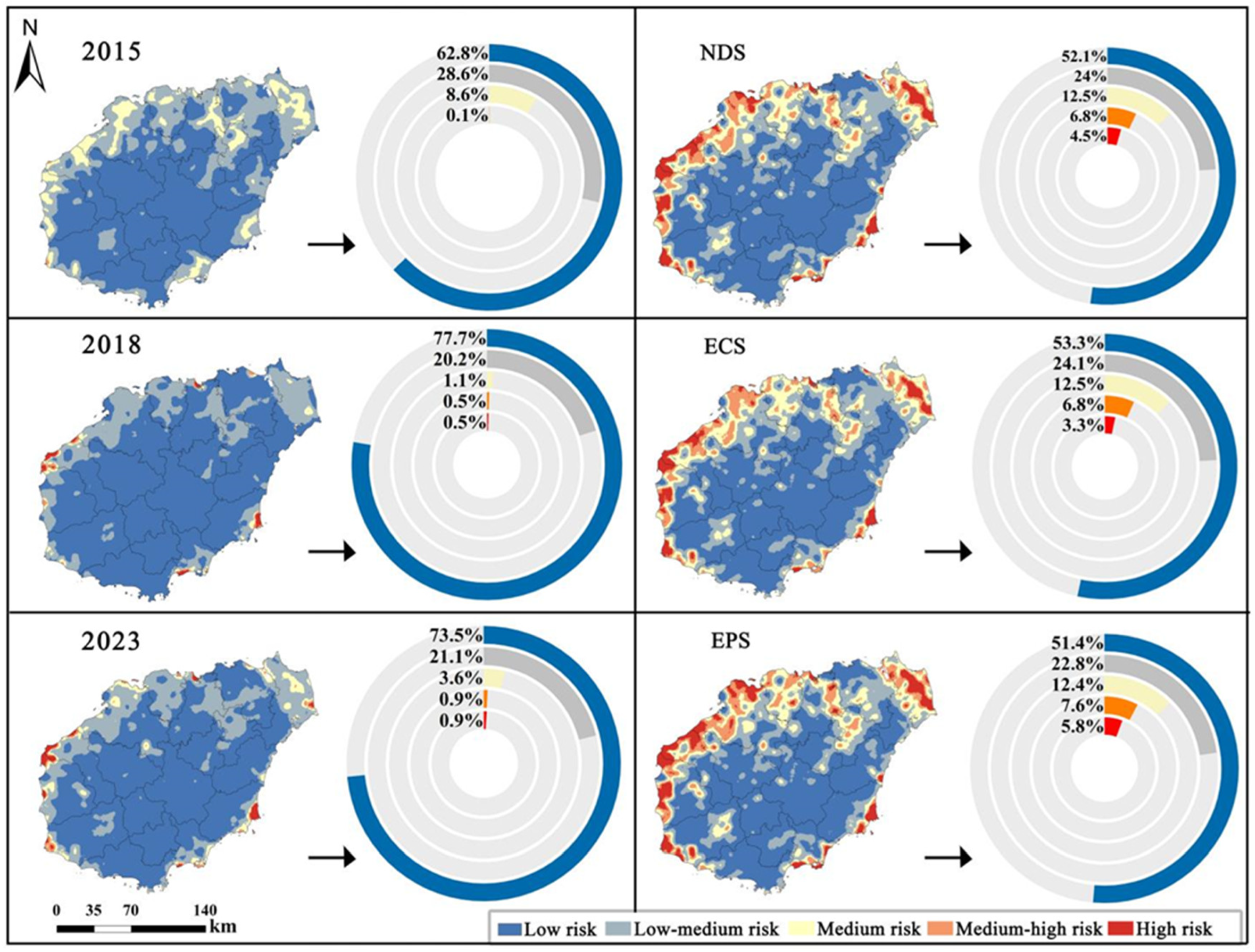
3.1.2. Projection of Future Landscape Patterns Under Different Scenarios
3.2. Changes in Landscape Pattern Risk: Past and Future Perspectives
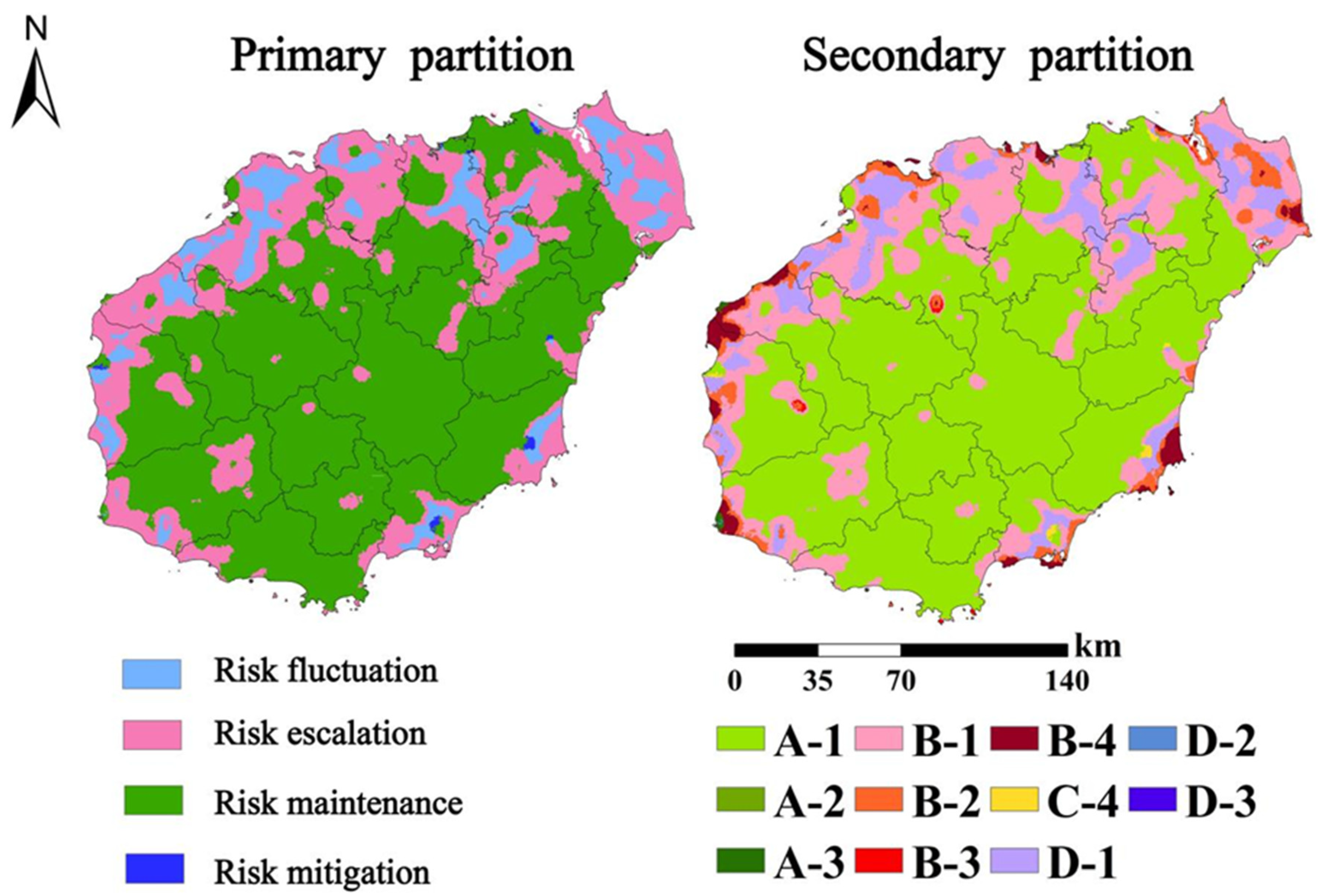
3.3. LER Management and Zoning
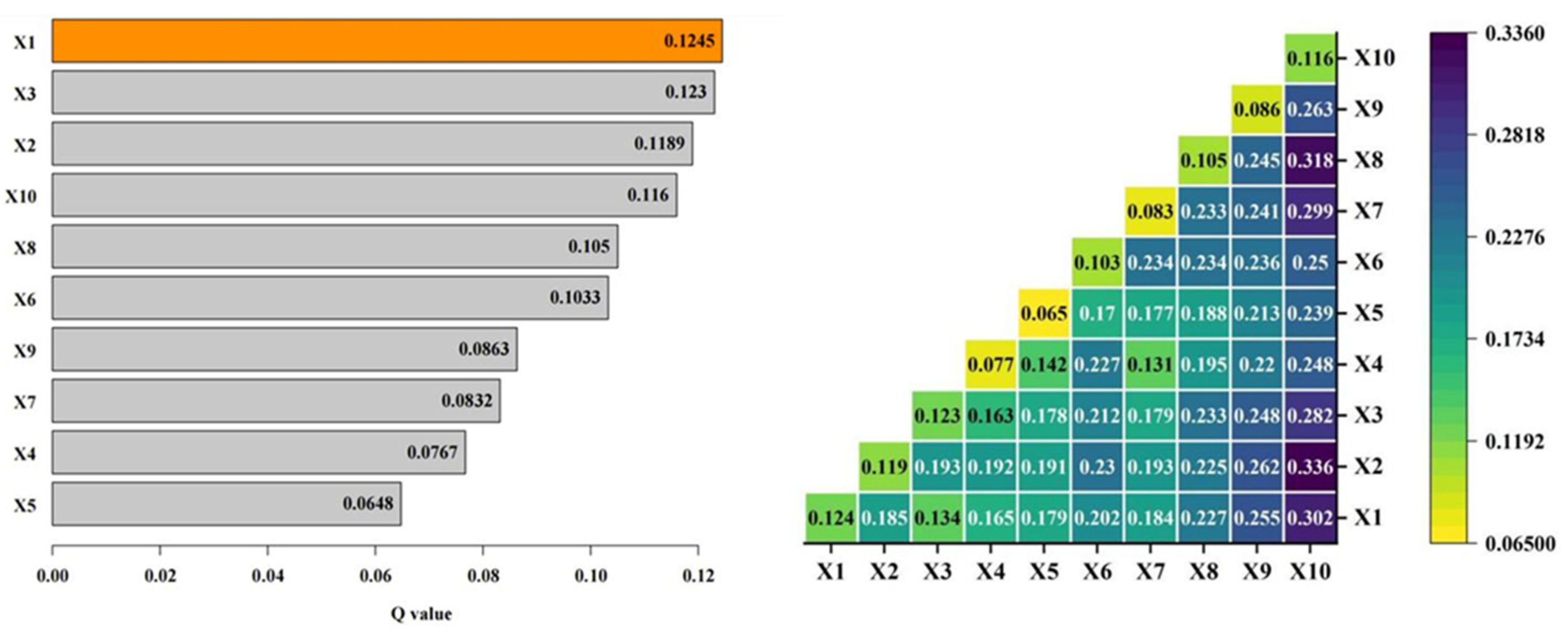
3.4. Macro-Scale Driving Factors
4. Discussion
4.1. Driving Mechanisms and Regulation Strategies of LER Under HPFTZ Development
- (1)
- High-risk areas: High-risk seriously uncontrollable areas and LER escalation areas require particular attention. Coastal regions, such as the high-risk seriously uncontrollable area (A-3) and the LER escalation area (B), should be subject to stricter ecological red line controls to limit the unregulated expansion of built-up land. Destructive activities such as land reclamation should be strictly prohibited, and rigorous environmental protection and ecological restoration measures should be implemented. Additionally, strengthening the risk early warning system is essential to promptly detect and address ecological risk events.
- (2)
- Medium-risk areas: Medium-risk areas, including urban–rural transition areas and agroforestry transition areas within HI (e.g., the medium-risk basically controllable area (A-2)), should be subject to the stricter regulation of village and township construction land to prevent its uncontrolled expansion into cropland and forestland. However, it is important to note that cropland, as a fundamental landscape for tropical agricultural security, continued to decline during the study period and across all simulated scenarios without effective mitigation. According to the Hainan Provincial Territorial Spatial Plan, the total amount of cropland should not fall below 4811.67 km2, of which at least 4253.33 km2 must be designated as permanent basic farmland. Additionally, the urban development boundary expansion should be controlled within 1.3 times the 2020 urban construction land scale. Considering the requirements of tropical agricultural security and land use planning, along with ecological protection, land use management, and ecological restoration, this study recommends adopting the “zoning control” strategy proposed by Luo [60]. In medium-risk areas, promoting eco-agriculture and forestry policies, along with implementing ecological restoration projects, can enhance the ecological functions of cropland and forestland. This approach aims to mitigate the impact of cropland fragmentation on ecosystems by converting certain sensitive areas into ecological buffer areas, ultimately enhancing the ecosystem’s stability.
- (3)
- Low-risk areas: In low-risk areas, including the central mountainous region dominated by the Tropical Rainforest National Park and its adjacent areas (e.g., the low-risk stable controllable area (A-1)), ecological protection should be prioritized while also considering regional economic development. An “eco-tourism–community co-management” model should be explored to achieve this balance. Furthermore, promoting low-impact eco-tourism is a crucial approach to fostering economic growth, as it ensures the sustainability of local economic development while providing strong support for the long-term conservation of natural landscapes. Additionally, biodiversity monitoring and habitat planning interventions should be implemented to safeguard regional biodiversity, including sustainable habitat conservation and corridor construction for flagship species such as the Hainan gibbon (Nomascus hainanus).
4.2. Contributions, Limitations, and Prospects
5. Conclusions
Author Contributions
Funding
Data Availability Statement
Conflicts of Interest
References
- Guo, A.; Yue, W.; Yang, J.; Li, M.; Xie, P.; He, T.; Zhang, M.; Yu, H. Quantifying the impact of urban ventilation corridors on thermal environment in Chinese megacities. Ecol. Indic. 2023, 156, 111072. [Google Scholar] [CrossRef]
- Ma, Y.; Zhang, S.; Yang, K.; Li, M. Influence of spatiotemporal pattern changes of impervious surface of urban megaregion on thermal environment: A case study of the Guangdong–Hong Kong–Macao Greater Bay Area of China. Ecol. Indic. 2020, 121, 107106. [Google Scholar] [CrossRef]
- Xie, B.; Jones, P.; Dwivedi, R.; Bao, L.; Liang, R. Evaluation, comparison, and unique features of ecological security in southwest China: A case study of Yunnan Province. Ecol. Indic. 2023, 153, 110453. [Google Scholar] [CrossRef]
- Ma, L.; Bo, J.; Li, X.; Fang, F.; Cheng, W. Identifying key landscape pattern indices influencing the ecological security of inland river basin: The middle and lower reaches of Shule River Basin as an example. Sci. Total Environ. 2019, 674, 424–438. [Google Scholar] [CrossRef]
- Peng, J.; Dang, W.; Liu, Y.; Zong, M.; Hu, X. Review on landscape ecological risk assessment. Acta Geogr. Sin. 2015, 70, 664–677. [Google Scholar] [CrossRef]
- Yang, F.; Jin, X.; Liu, J.; Zhang, X.; Song, J.; Li, Q.; Zhou, Y. Assessing landscape ecological risk in rapidly urbanized areas from the perspective of spatiotemporal dynamics. Trans. Chin. Soc. Agric. Eng. 2023, 39, 253–261. [Google Scholar] [CrossRef]
- Wang, X.; Zhu, T.; Jiang, C. Landscape ecological risk based on optimal scale and its tradeoff/synergy with human activities: A case study of the Nanjing metropolitan area, China. Ecol. Indic. 2025, 170, 113040. [Google Scholar] [CrossRef]
- Wei, Y.; Zhou, P.; Zhang, L.; Zhang, Y. Spatio-temporal evolution analysis of land use change and landscape ecological risks in rapidly urbanizing areas based on Multi-Situation simulation—A case study of Chengdu Plain. Ecol. Indic. 2024, 166, 112245. [Google Scholar] [CrossRef]
- Wu, Y.; Qin, F.; Li, L.; Dong, X. Exploring landscape ecological risk with human activity intensity and correlation in the Kuye River Basin. Front. Ecol. Evol. 2024, 12, 1409515. [Google Scholar] [CrossRef]
- Du, L.; Dong, C.; Kang, X.; Qian, X.; Gu, L. Spatiotemporal evolution of land cover changes and landscape ecological risk assessment in the Yellow River Basin, 2015–2020. J. Environ. Manag. 2023, 332, 117149. [Google Scholar] [CrossRef]
- Wang, B.; Yu, F.; Teng, Y.; Cao, G.; Zhao, D.; Zhao, M. A SEEC Model Based on the DPSIR Framework Approach for Watershed Ecological Security Risk Assessment: A Case Study in Northwest China. Water 2022, 14, 106. [Google Scholar] [CrossRef]
- Dong, Y.; Wang, Y.; Zeng, W. Analyzing “Source-Sink” Pattern of NPS Pollution Risks in Upper Reaches of Erhai Lake Basin by Minimum Cumulative Resistance Model. Bull. Soil Water Conserv. 2022, 42, 166–175. [Google Scholar] [CrossRef]
- Xu, X.; Lin, H.; Fu, Z. Probe into the method of regional ecological risk assessment—A case study of wetland in the Yellow River Delta in China. J. Environ. Manag. 2003, 70, 253–262. [Google Scholar] [CrossRef]
- Hayes, E.H.; Landis, W.G. Regional Ecological Risk Assessment of a Near Shore Marine Environment: Cherry Point, WA. Hum. Ecol. Risk Assess. 2010, 10, 299–325. [Google Scholar] [CrossRef]
- Chen, J.; Li, T. Landscape Ecological Risk Analysis for Jingzhou City Based on PSR Model and Projection Pursuit Method. Acta Sci. Nat. Univ. Pekin. 2017, 53, 731–740. [Google Scholar] [CrossRef]
- Lautenbach, S.; Kugel, C.; Lausch, A.; Seppelt, R. Analysis of historic changes in regional ecosystem service provisioning using land use data. Ecol. Indic. 2010, 11, 676–687. [Google Scholar] [CrossRef]
- Rossi, P.; Pecci, A.; Amadio, V.; Rossi, O.; Soliani, L. Coupling indicators of ecological value and ecological sensitivity with indicators of demographic pressure in the demarcation of new areas to be protected: The case of the Oltrepò Pavese and the Ligurian-Emilian Apennine area (Italy). Landsc. Urban Plan. 2007, 85, 12–26. [Google Scholar] [CrossRef]
- Zhang, S.; Jiang, H.; Yu, H.; Feng, X.; Fan, M. Construction of landscape ecological network based on MCR risk assessment Model: A case study of Liaoning Province, China. Ecol. Indic. 2024, 166, 112549. [Google Scholar] [CrossRef]
- Deng, R.; Ding, X.; Wang, J. Landscape Ecological Risk Assessment and Spatial Pattern Evolution Analysis of the Central Yunnan Urban Agglomeration from 1995 to 2020 Based on Land Use/Cover Change. Sustainability 2023, 15, 16641. [Google Scholar] [CrossRef]
- Wang, H.; Liu, X.; Zhao, C.; Chang, Y.; Liu, Y.; Zang, F. Spatial-temporal pattern analysis of landscape ecological risk assessment based on land use/land cover change in Baishuijiang National nature reserve in Gansu Province, China. Ecol. Indic. 2021, 124, 107454. [Google Scholar] [CrossRef]
- Liang, L.; Sun, Y.; Guan, Q.; Pan, N.; Du, Q.; Mi, J.; Shan, Y. Projection of landscape ecological risk and exploration of terrain effects in the Qilian Mountains, China. Land Degrad. Dev. 2023, 34, 4575–4593. [Google Scholar] [CrossRef]
- Yang, N.; Zhang, T.; Li, J.; Feng, P.; Yang, N. Landscape ecological risk assessment and driving factors analysis based on optimal spatial scales in Luan River Basin, China. Ecol. Indic. 2024, 169, 112821. [Google Scholar] [CrossRef]
- Yu, M.; Liu, Y.; Zhang, Y. Multi-scenario Prediction of Future Land Use Change and Landscape Ecological Risk on the Qingzang Plateau. Resour. Environ. Yangtze Basin 2024, 33, 2204–2218. Available online: https://yangtzebasin.whlib.ac.cn/CN/10.11870/cjlyzyyhj202410011 (accessed on 3 March 2025).
- Hou, P.; Zhai, J.; Cao, W.; Yang, M.; Cai, M.; Li, J. Evaluation on ecosystem changes and protection of the national key ecological function zones in mountainous areas of central Hainan Island. Acta Ecol. Sin. 2018, 73, 429–441. [Google Scholar] [CrossRef]
- Zhang, L.; Liao, J.; Yuan, X.; Mu, X.; Song, Q.; Bi, J. Remote Sensing Analysis of Coastline Changes in Hainan Island during 1987–2017. Trop. Geogr. 2020, 40, 659–674. [Google Scholar] [CrossRef]
- Lei, J.; Chen, Z.; Chen, X.; Li, Y.; Wu, T. Spatio-temporal changes of land use and ecosystem services value in Hainan Island from 1980 to 2018. Acta Ecol. Sin. 2020, 40, 4760–4773. [Google Scholar] [CrossRef]
- Wu, W.; Huang, Z.; Sun, Z.; Zhang, J.; Wang, S.; Fang, M.; Yang, H.; Lu, H.; Guo, G.; Liu, W. Simulation and attribution analysis of terrestrial ecosystem carbon storage of Hainan Island from 2015 to 2050. Sci. Total Environ. 2024, 917, 170348. [Google Scholar] [CrossRef] [PubMed]
- Hu, J.; Mao, M.; Gong, W.; Liu, T.; Qiu, X.; Wu, G.; Xie, Y. Ecological Risk Assessment and Simulation of Haikou City Based on PSR-OWA Model. Res. Soil Water Conserv. 2024, 31, 301–314. [Google Scholar] [CrossRef]
- Chen, X.; Xie, G.; Zhang, J. Landscape ecological risk assessment of land use changes in the coastal area of Haikou City in the past 30 years. Acta Ecol. Sin. 2021, 41, 975–986. [Google Scholar] [CrossRef]
- Zhang, L.; Lei, J.; Cheng, Z.; Chen, Y.; Zhou, P. Spatiotemporal evolution characteristics and influencing factors of landscape ecological risks in the three major basins of Hainan Island, China. Acta Ecol. Sin. 2025, 45, 1646–1658. [Google Scholar] [CrossRef]
- Han, N.; Yu, M.; Jia, P. Multi-Scenario Landscape Ecological Risk Simulation for Sustainable Development Goals: A Case Study on the Central Mountainous Area of Hainan Island. Int. J. Environ. Res. Public Health 2022, 19, 4030. [Google Scholar] [CrossRef] [PubMed]
- Xiong, C.; Liang, Y.; Hu, Y.; Ni, X.; Luan, Q. Net Effect and Mechanism Analysis of Hainan International Tourism Island Construction on Urban Construction Land Expansion. China Land Sci. 2022, 36, 59–68. [Google Scholar] [CrossRef]
- Lei, J.; Chen, Y.; Li, L.; Chen, Z.; Chen, X.; Wu, T.; Li, Y. Spatiotemporal change of habitat quality in Hainan Island of China based on changes in land use. Ecol. Indic. 2022, 145, 109707. [Google Scholar] [CrossRef]
- Wu, T.; Chen, Y.; Chen, Z.; Lei, J.; Chen, X.; Li, Y. Analysis on the Spatial Distribution Characteristics of Representative Populations in Tropical Rainforest of Hainan. For. Grassl. Resour. Res. 2023, 5, 133–141. [Google Scholar] [CrossRef]
- Li, S.; Tong, Y.; He, B. Prediction of Tourism Carbon Peak and Carbon Neutrality Based on Multiple Scenarios: A Case Study of Hainan Province. Econ. Geogr. 2023, 43, 230–240. [Google Scholar] [CrossRef]
- Wang, K.; Yan, M.; Zhang, L.; Wang, P.; Chen, W. Evaluation of Land Use Suitability in the Coastal Zone of Hainan Island based on LandUSEM. Remote Sens. Technol. Appl. 2022, 37, 1140–1148. Available online: http://www.rsta.ac.cn/EN/abstract/abstract3571.shtml (accessed on 3 March 2025).
- Tian, P.; Zhao, G.; Mu, X.; Wen, Z.; Wang, F. A modified RUSLE model to estimate sediment yield in the Huangfuchuan watershed. Resour. Sci. 2015, 37, 832–840. Available online: https://www.resci.cn/CN/Y2015/V37/I4/832 (accessed on 3 March 2025).
- Xiao, Q.; Hu, D.; Xiao, Y. Assessing changes in soil conservation ecosystem services and causal factors in the Three Gorges Reservoir region of China. J. Clean. Prod. 2016, 163, S172–S180. [Google Scholar] [CrossRef]
- Du, J.; Wang, Y.; Pan, Y.; Wang, J. Ecological risk assessment and ecological security pattern construction of county-level landscape in plateau valley: A case study in Yongping County, Dali Prefecture, Yunnan Province. Chin. J. Ecol. 2024, 43, 1509–1520. [Google Scholar] [CrossRef]
- Liu, X.; Li, X.; Jiang, D. Landscape pattern identification and ecological risk assessment using land-use change in the Yellow River Basin. Trans. Chin. Soc. Agric. Eng. 2021, 37, 265–274. [Google Scholar] [CrossRef]
- Peng, J.; Zong, M.; Hu, Y.; Liu, Y.; Wu, J. Assessing Landscape Ecological Risk in a Mining City: A Case Study in Liaoyuan City, China. Sustainability 2015, 7, 8312–8334. [Google Scholar] [CrossRef]
- Tian, J.; Shao, S.; Huang, Y.; Yu, M. Towards a Core Set of Landscape Metrics for Land Use: A Case Study from Guangzhou, China. Geomat. Inf. Sci. Wuhan Univ. 2019, 44, 443–450. [Google Scholar] [CrossRef]
- Munyati, C.; Sinthumule, N.I. Comparative suitability of ordinary kriging and Inverse Distance Weighted interpolation for indicating intactness gradients on threatened savannah woodland and forest stands. Environ. Sustain. Indic. 2021, 12, 100151. [Google Scholar] [CrossRef]
- Liang, X.; Guan, Q.; Clarke, K.C.; Liu, S.; Wang, B.; Yao, Y. Understanding the drivers of sustainable land expansion using a patch-generating land use simulation (PLUS) model: A case study in Wuhan, China. Comput. Environ. Urban Syst. 2021, 85, 101569. [Google Scholar] [CrossRef]
- Fan, H.; Si, Q.; Dong, W.; Lu, G.; Liu, X. Land Use Change and Landscape Ecological Risk Prediction in Urumqi under the Shared Socio-Economic Pathways and the Representative Concentration Pathways (SSP-RCP) Scenarios. Sustainability 2023, 15, 14214. [Google Scholar] [CrossRef]
- Wang, Z.; Guo, M.; Zhang, D.; Chen, R.; Xi, C.; Yang, H. Coupling the Calibrated GlobalLand30 Data and Modified PLUS Model for Multi-Scenario Land Use Simulation and Landscape Ecological Risk Assessment. Remote Sens. 2023, 15, 5186. [Google Scholar] [CrossRef]
- Xie, J.; Zhao, J.; Zhang, S.; Sun, Z. Optimal Scale and Scenario Simulation Analysis of Landscape Ecological Risk Assessment in the Shiyang River Basin. Sustainability 2023, 15, 15883. [Google Scholar] [CrossRef]
- Luan, C.; Liu, R.; Zhang, Q.; Sun, J.; Liu, J. Multi-objective land use optimization based on integrated NSGA–II–PLUS model: Comprehensive consideration of economic development and ecosystem services value enhancement. J. Clean. Prod. 2024, 434, 140306. [Google Scholar] [CrossRef]
- Nie, W.; Xu, B.; Yang, F.; Shi, Y.; Liu, B.; Wu, R.; Lin, W.; Pei, H.; Bao, Z. Simulating future land use by coupling ecological security patterns and multiple scenarios. Sci. Total Environ. 2023, 859, 160262. [Google Scholar] [CrossRef]
- Jiao, Z.; Jiang, Y.; He, T.; Lu, Y.; Xu, X. Land use change simulation: Progress, challenges, and prospects. Acta Ecol. Sin. 2022, 42, 5165–5176. [Google Scholar] [CrossRef]
- He, Q.; Zhang, Z.; Zhang, Y.; Sun, T.; Wang, W.; Zhang, Z. Spatiotemporal Evolution and Driving Mechanisms of Ecological Risk in the Yuncheng Salt Lake Wetland, China. Water 2025, 17, 524. [Google Scholar] [CrossRef]
- Meng, R.; Meng, Z.; Li, H.; Cai, J.; Qin, L. Changes in landscape ecological risk in the Beijing-Tianjin Sandstorm source control project area from a spatiotemporal perspective. Ecol. Indic. 2024, 167, 112569. [Google Scholar] [CrossRef]
- Slamet, A.H.H.; Dhandy, R.; Brillyantina, S.; Wulandari, S.A.; Mutmainah, D.N.; Ubaidillah, W. Mapping the Suitability of Milkfish Ponds in Sidoarjo District Using Geographic Information Systems (GIS). IOP Conf. Ser. Earth Environ. Sci. 2024, 1338, 012001. [Google Scholar] [CrossRef]
- Wang, J.; Xu, C. Geodetector: Principle and prospective. Acta Ecol. Sin. 2017, 72, 116–134. [Google Scholar] [CrossRef]
- Yongze, S.; Jinfeng, W.; Yong, G.; Chengdong, X. An optimal parameters-based geographical detector model enhances geographic characteristics of explanatory variables for spatial heterogeneity analysis: Cases with different types of spatial data. GISci. Remote Sens. 2020, 57, 593–610. [Google Scholar] [CrossRef]
- Duan, X.; Gong, W.; Sun, Y.; Liu, T.; Qiu, X.; Zhang, Y. Land Use Change and Its Impact on Temporal and Spatial Evolution of Carbon Storage in Coastal Zone of Hainan Island. Bull. Soil Water Conserv. 2022, 42, 301–311. [Google Scholar] [CrossRef]
- Zhang, Y.; Yang, Z.; Yang, R.; Liu, F.; He, Y.; Cao, L.; Yang, J.; Zhang, J. Ecological risk assessment and response prediction caused by LUCC in the central Yunnan Province. Sci. Rep. 2025, 15, 2416. [Google Scholar] [CrossRef]
- Xu, B.; Peng, Y.; Li, L.; Fu, S.; Feng, Y.; Yu, J. Study on habitat quality and ecological risk in Manas River Basin based on landscape pattern. Res. Soil Water Conserv. 2025, 32, 328–335. [Google Scholar] [CrossRef]
- Mu, H.; Guo, S.; Zhang, X.; Yuan, B.; Xia, Z.; Tang, P.; Zhang, W.; Zhang, P.; Li, X.; Du, P. Moving in the landscape: Omnidirectional connectivity dynamics in China from 1985 to 2020. Environ. Impact Assess. Rev. 2025, 110, 107721. [Google Scholar] [CrossRef]
- Luo, Q.; Liu, F.; Zhu, K. Spatial-temporal evolution and driving forces of landscape ecological risk in the Chishui river basin (Guizhou section). Chin. J. Eco-Agric. 2025, 33, 550–562. Available online: http://kns.cnki.net/kcms/detail/13.1432.s.20250114.1803.001.html (accessed on 3 March 2025).
- Wei, S.; Zhang, H.; Xu, Z.; Lin, G.; Lin, Y.; Liang, X.; Ling, J.; Wee, A.K.S.; Lin, H.; Zhou, Y.; et al. Coastal urbanization may indirectly positively impact growth of mangrove forests. Commun. Earth Environ. 2024, 5, 608. [Google Scholar] [CrossRef]


| Variable | Type of Data | Spatial Resolution | Source |
|---|---|---|---|
| LULCC data | LULCC of HI (2015, 2018, and 2023) | 30 m | RESDC of the Chinese Academy of Sciences (http://www.resdc.cn/, accessed on 2 February 2025) |
| Socioeconomic data | Gross domestic product (GDP) | 30 m | Hainan Statistical Yearbook (https://www.hainan.gov.cn/, accessed on 1 February 2025) |
| Local tax revenue | |||
| Year-end resident population | |||
| Number of tourists | |||
| Newly added fixed assets | |||
| Output value of farming, forestry, animal, husbandry, and fisheries | |||
| Retail sales of consumer goods | |||
| Urban built-up areas | |||
| Per capita food production | |||
| Energy consumption per unit of GDP | |||
| Climate and environmental data | Soil erosion degree | 30 m | Big Data Center of Sciences in Cold and Arid Regions (https://www.fao.org/home/zh/, accessed on 3 February 2025) |
| Temperature | National Meteorological Information Center (https://data.cma.cn/, accessed on 2 February 2025) | ||
| Precipitation | |||
| Digital elevation model (DEM) | Geospatial Data Cloud (http://www.gscloud.cn/, accessed on 1 February 2025) | ||
| Distance variables | Distance to roads | 30 m | National Catalogue Service for Geographic Information (http://www.webmap.cn, accessed on 4 February 2025) |
| Distance to settlements | |||
| Distance to provincial highway | |||
| Distance to railway |
| NDS | ECS | EPS | ||||||||||||||||
|---|---|---|---|---|---|---|---|---|---|---|---|---|---|---|---|---|---|---|
| A | B | C | D | E | F | A | B | C | D | E | F | A | B | C | D | E | F | |
| A | 1 | 1 | 1 | 1 | 1 | 1 | 1 | 1 | 0 | 0 | 1 | 0 | 1 | 1 | 1 | 1 | 1 | 1 |
| B | 1 | 1 | 1 | 1 | 1 | 1 | 0 | 1 | 0 | 0 | 0 | 0 | 1 | 1 | 1 | 1 | 1 | 1 |
| C | 1 | 1 | 1 | 1 | 1 | 1 | 0 | 1 | 1 | 1 | 0 | 0 | 1 | 1 | 1 | 1 | 1 | 1 |
| D | 0 | 0 | 0 | 1 | 0 | 0 | 0 | 0 | 0 | 1 | 0 | 0 | 1 | 1 | 1 | 1 | 1 | 1 |
| E | 0 | 0 | 0 | 0 | 1 | 0 | 1 | 0 | 0 | 1 | 1 | 1 | 0 | 0 | 0 | 0 | 1 | 0 |
| F | 1 | 1 | 1 | 1 | 1 | 1 | 1 | 1 | 0 | 0 | 1 | 1 | 1 | 1 | 1 | 1 | 1 | 1 |
| Primary Partition | Secondary Partition | Risk Level Combination | ||
|---|---|---|---|---|
| No. | Name | No. | Name | (2015-2023-2033) |
| A | LER Maintenance | 1 | Low-risk stable controllable area | Low–Low–Low |
| 2 | Medium-risk basically controllable area | Medium–Medium–Medium | ||
| 3 | High-risk seriously uncontrollable area | High–High–High | ||
| B | LER Escalation | 1 | Low-risk potential escalation area | Low–Low–Medium, Low–Low–High |
| 2 | Medium-risk potential escalation area | Low–Medium–High, Medium–Medium–High | ||
| 3 | Medium-risk basically controllable area | Low–Medium–Medium | ||
| 4 | High-risk basically uncontrollable area | Low–High–High, Medium–High–High | ||
| C | LER Mitigation | 4 | Low-risk mitigation maintenance area | Medium–Low–Low, High–Low–Low |
| D | LER Fluctuation | 1 | Low-risk potential fluctuation area | Medium–Low–Medium, Medium–Low–High |
| High–Low–Medium, High–Low–High | ||||
| 2 | Medium-risk potential fluctuation area | High–Medium–High | ||
| 3 | Medium-risk potential mitigation area | Low–Medium–Low | ||
| Basis of Judgment | Interactive Relationship |
|---|---|
| q(X1∩X2) < Min(q(X1∩X2)) | Nonlinear attenuation |
| Min(q(X1), q(X2)) < q(X1∩X2) < Max(q(X1), q(X2)) | Single-factor nonlinear attenuation |
| q(X1∩X2) > Max(q(X1), q(X2)) | Two-factor enhancement |
| q(X1∩X2) = q(X1) + q(X2) | Single-factor independence |
| q(X1∩X2) > q(X1) + q(X2) | Nonlinear enhancement |
| Land Type | 2015 | 2018 | 2023 | |||
|---|---|---|---|---|---|---|
| Area (km2) | Percentage | Area (km2) | Percentage | Area (km2) | Percentage | |
| Cropland | 8719.13 | 25.53% | 8688.46 | 25.35% | 7712.85 | 22.49% |
| Forestland | 21,564.77 | 63.14% | 21,501.75 | 62.75% | 22,252.89 | 64.89% |
| Grassland | 1116.57 | 3.27% | 1148.85 | 3.35% | 978.04 | 2.85% |
| Water bodies | 1412.87 | 4.14% | 1493.17 | 4.36% | 1521.29 | 4.44% |
| Built-up land | 1252.54 | 3.67% | 1348.39 | 3.93% | 1757.39 | 5.12% |
| Unused land | 89.57 | 0.26% | 87.60 | 0.26% | 73.07 | 0.21% |
| Land Type | NDS | ECS | EPS | |||
|---|---|---|---|---|---|---|
| Area (km2) | Percentage | Area (km2) | Percentage | Area (km2) | Percentage | |
| Cropland | 6213.96 | 18.12% | 6340.17 | 18.49% | 6212.6919 | 18.12% |
| Forestland | 23,332.59 | 68.06% | 23,444.22 | 68.38% | 23,254.7796 | 67.83% |
| Grassland | 742.11 | 2.16% | 741.19 | 2.16% | 742.752 | 2.17% |
| Water bodies | 1555.30 | 4.54% | 1521.19 | 4.44% | 1537.2495 | 4.48% |
| Built-up land | 2376.10 | 6.93% | 2170.33 | 6.33% | 2484.009 | 7.25% |
| Unused land | 64.66 | 0.19% | 67.65 | 0.20% | 53.2503 | 0.16% |
| Primary Partition | Secondary Partition | ||||
|---|---|---|---|---|---|
| No. | Name | Area (km2) | No. | Name | Area (km2) |
| A | LER Maintenance | 22,325.19 | 1 | Low-risk stable controllable area | 22,295.43 |
| 2 | Medium-risk basically controllable area | 1.56 | |||
| 3 | High-risk seriously uncontrollable area | 28.20 | |||
| B | LER Escalation | 9228.80 | 1 | Low-risk potential escalation area | 7407.19 |
| 2 | Medium-risk potential escalation area | 1180.37 | |||
| 3 | Medium-risk basically controllable area | 49.73 | |||
| 4 | High-risk basically uncontrollable area | 591.51 | |||
| C | LER Mitigation | 68.65 | 4 | Low-risk mitigation maintenance area | 68.65 |
| D | LER Fluctuation | 2590.39 | 1 | Low-risk potential fluctuation area | 2588.19 |
| 2 | Medium-risk potential fluctuation area | 2.14 | |||
| 3 | Medium-risk potential mitigation area | 0.06 | |||
Disclaimer/Publisher’s Note: The statements, opinions and data contained in all publications are solely those of the individual author(s) and contributor(s) and not of MDPI and/or the editor(s). MDPI and/or the editor(s) disclaim responsibility for any injury to people or property resulting from any ideas, methods, instructions or products referred to in the content. |
© 2025 by the authors. Licensee MDPI, Basel, Switzerland. This article is an open access article distributed under the terms and conditions of the Creative Commons Attribution (CC BY) license (https://creativecommons.org/licenses/by/4.0/).
Share and Cite
Ma, Y.; Mao, M.; Xie, Z.; Mao, S.; Wang, Y.; Chen, Y.; Xu, J.; Liu, T.; Gong, W.; Wu, L. Spatiotemporal Dynamics and Simulation of Landscape Ecological Risk and Ecological Zoning Under the Construction of Free Trade Pilot Zones: A Case Study of Hainan Island, China. Land 2025, 14, 940. https://doi.org/10.3390/land14050940
Ma Y, Mao M, Xie Z, Mao S, Wang Y, Chen Y, Xu J, Liu T, Gong W, Wu L. Spatiotemporal Dynamics and Simulation of Landscape Ecological Risk and Ecological Zoning Under the Construction of Free Trade Pilot Zones: A Case Study of Hainan Island, China. Land. 2025; 14(5):940. https://doi.org/10.3390/land14050940
Chicago/Turabian StyleMa, Yixi, Mingjiang Mao, Zhuohong Xie, Shijie Mao, Yongshi Wang, Yuxin Chen, Jinming Xu, Tiedong Liu, Wenfeng Gong, and Lingbing Wu. 2025. "Spatiotemporal Dynamics and Simulation of Landscape Ecological Risk and Ecological Zoning Under the Construction of Free Trade Pilot Zones: A Case Study of Hainan Island, China" Land 14, no. 5: 940. https://doi.org/10.3390/land14050940
APA StyleMa, Y., Mao, M., Xie, Z., Mao, S., Wang, Y., Chen, Y., Xu, J., Liu, T., Gong, W., & Wu, L. (2025). Spatiotemporal Dynamics and Simulation of Landscape Ecological Risk and Ecological Zoning Under the Construction of Free Trade Pilot Zones: A Case Study of Hainan Island, China. Land, 14(5), 940. https://doi.org/10.3390/land14050940