1. Introduction
Despite significant differences between physical and digital land, we can think of similarities in terms of their use and valuation. One can find parallels between physical and digital land as follows. Improvement of and better accessibility to physical land’s infrastructure, including roads, increases physical land’s property values. Similar principles apply to real estate in the metaverse. The value of digital land may increase with improvements in digital infrastructure, such as virtual pathways, digital accessibility to services, and virtual connectivity between spaces in the metaverse. Further, various factors, including demographics, economic growth, and infrastructure development, all shape real estate investment in physical land, while the growth of the metaverse, among other factors, influences real estate investments in digital land. Understanding these parallels enables one to see how virtual real estate can grow and evolve.
Much like physical land, digital land and real estate can grow. It is important to determine what factors are more important in driving growth. Since digital plots can represent offices and entertainment (and thus, jobs), what is the role of employment as virtual land expands? Without the constraints of physicality, will the changes in land use, such as digital infrastructure improvement, alter digital land and real estate in the metaverse?
In order for future City- and metaverse environments to successfully replicate physical reality at various scales, one must understand what factors may potentially drive the growth of the physical-world developed land. We need to better understand the linkage between development-caused factors, such as increased employment, greater vehicle traffic, and changes in surrounding land use. In this study, we are using the physical land as an example. Specifically, we offer a spatial perspective on factors of urban land growth, including employment and road improvement. Here, we study the relationship between infrastructure (road) development, employment, amount of travel, and land use change in the physical world, which may help us understand this connection in the digital land and real estate domain.
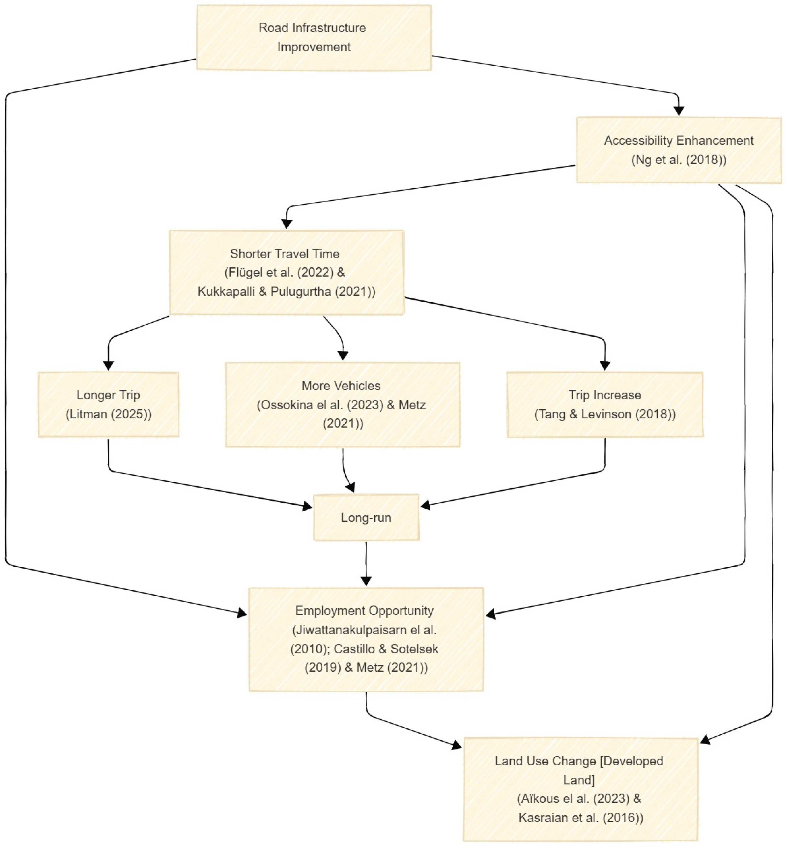
In the physical world, the transportation network is the backbone of social development and land use expansion [
1,
2,
3]. Transportation systems and land use co-exist and influence the landform. So, any land-use changes alter travel behavior and demand, influencing vehicle flows and road infrastructure. Furthermore, vehicle flows drive the construction and improvement of road network facilities. Finally, improved and new transportation infrastructure enhances accessibility and mobility patterns, leading to the relocation of socioeconomic activities and land use [
4,
5]. Most of the time, the governments take different public policies to road improvements and development to support integration, connect various functional areas and administrative regions, aggregation of logistics, energy, information, capital, and other flows [
6]. For example, in the USA, the Interstate Highway System, a network of controlled-access highways that forms a part of the National Highway System of the United States, was introduced to support national security and facilitate interstate travel and commerce [
7]. Although road construction and improvement, which includes activities such as widening, resurfacing, and adding new lanes or features to existing roads, can be carried out for several purposes, they can also lead to economic development [
8,
9,
10,
11]. Diaconu et al. [
12] observed that new highway infrastructure in Romania led to substantial land use change, replacing agricultural land with industrial and built-up areas. Similarly, Aïkous et al. [
13] demonstrated that highway expansion in Montreal significantly increased the probability of industrial and commercial construction near a new access ramp.
There is little doubt among transportation researchers that improving or expanding road capacity leads to increased vehicle use [
14,
15]. Road improvements follow the fundamental principles of economics: when the price of some goods decreases, an individual tends to consume more of those goods [
10]. In other words, wider and new roads increase traffic speeds and reduce travel costs, thereby inducing additional vehicle travel [
16,
17,
18]. In the short time frame, residential and employment locations remained fixed, and faster peak period road speeds pulled drivers from alternative routes, modes, and times of day to use those improved roads [
19]. Then, in the long run, this additional traffic encourages additional social and economic activities to relocate around these improved transportation networks [
14,
20,
21,
22,
23,
24,
25]. Vice versa, changes in land use influence travel patterns, determining traffic flows on roads, which has led to improving those road facilities [
13,
26].
Researchers use different modeling techniques to improve the understanding of road development and land use change. Nelson et al. [
27] conducted a study in Colombia using multinomial, nested, and random parameter models to uncover the impact of road resurfacing and deforestation. The study could not find any direct connection between road improvements and deforestation due to particular trees found in remote areas with high elevations and steep slopes. Levinson et al. [
4] developed A Simulator of Integrated Growth of Network Growth and Land Use (SIGNAL) model to investigate the co-evolution of transportation networks and land-use development. The study combined travel demand, road investment, accessibility, and land use models to develop this composite model. Rui and Ban [
28] developed a dynamic growth model that combines two submodels: (1) a vector road growth model and (2) a grid land use model for long-term urban growth. Patarasuk and Binford [
10] conducted a longitudinal study from 1986 to 2006 in Thailand, during which the land cover change and the construction of new roads were observed. The study employed a 7-km buffer along the road and observed land cover changes within the buffer area to establish a relationship between land use and road improvement. Alphan [
29] examined the relationship between road development and changes in agricultural land use. The study divided the area into fishnets and calculated the percentage change in landscape and road density to determine the correlation. Mo et al. [
30] conducted a study in China to assess the ecological risk associated with road expansion using ecological risk indices and road network kernel density. Zhao et al. [
6] utilized land use and land cover data, as well as kernel density of road networks, to perform overlay and regression analysis, exploring the relationship between road improvements and land use.
Most studies used microsimulation or density-based methods to explore the relationship between road improvements and land use. However, there is a significant gap in the recent literature regarding the differentiation of land use patterns due to road improvements in rural and urban areas and whether land use changes occurred solely due to road improvements or also as a result of natural growth resulting from population increases. This study aims to fill this crucial gap. We test the hypothesis that some factors may differently impact land development. Specifically, we analyze the effect on land development by employment, improvements in road infrastructure, and mobility.
We study the relationship between infrastructure (road) development, employment, amount of travel, and land use change in the physical world. The definitions of what constitutes developedland density, employment density, road infrastructure improvement, urban and rural are provided below.
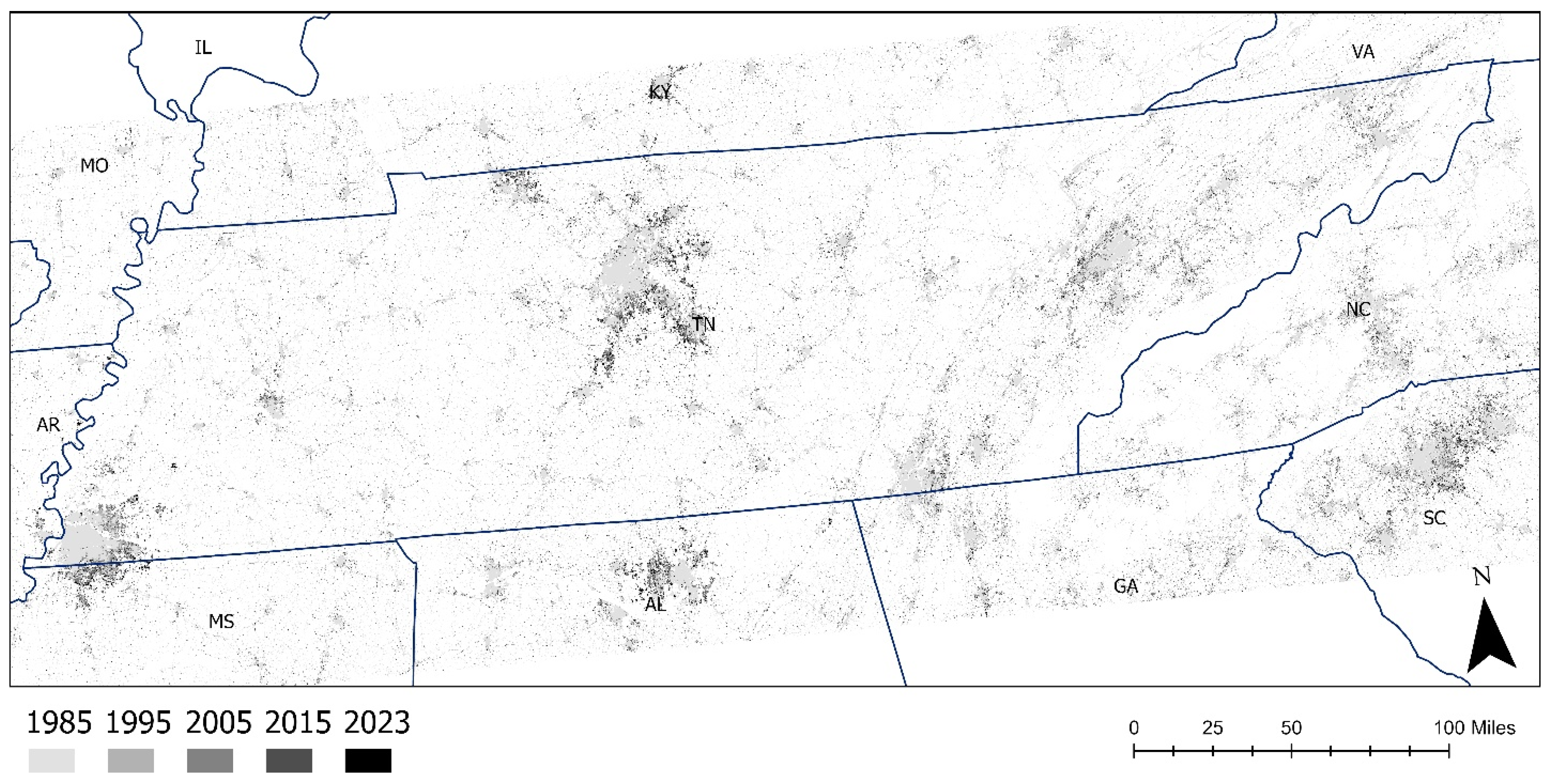
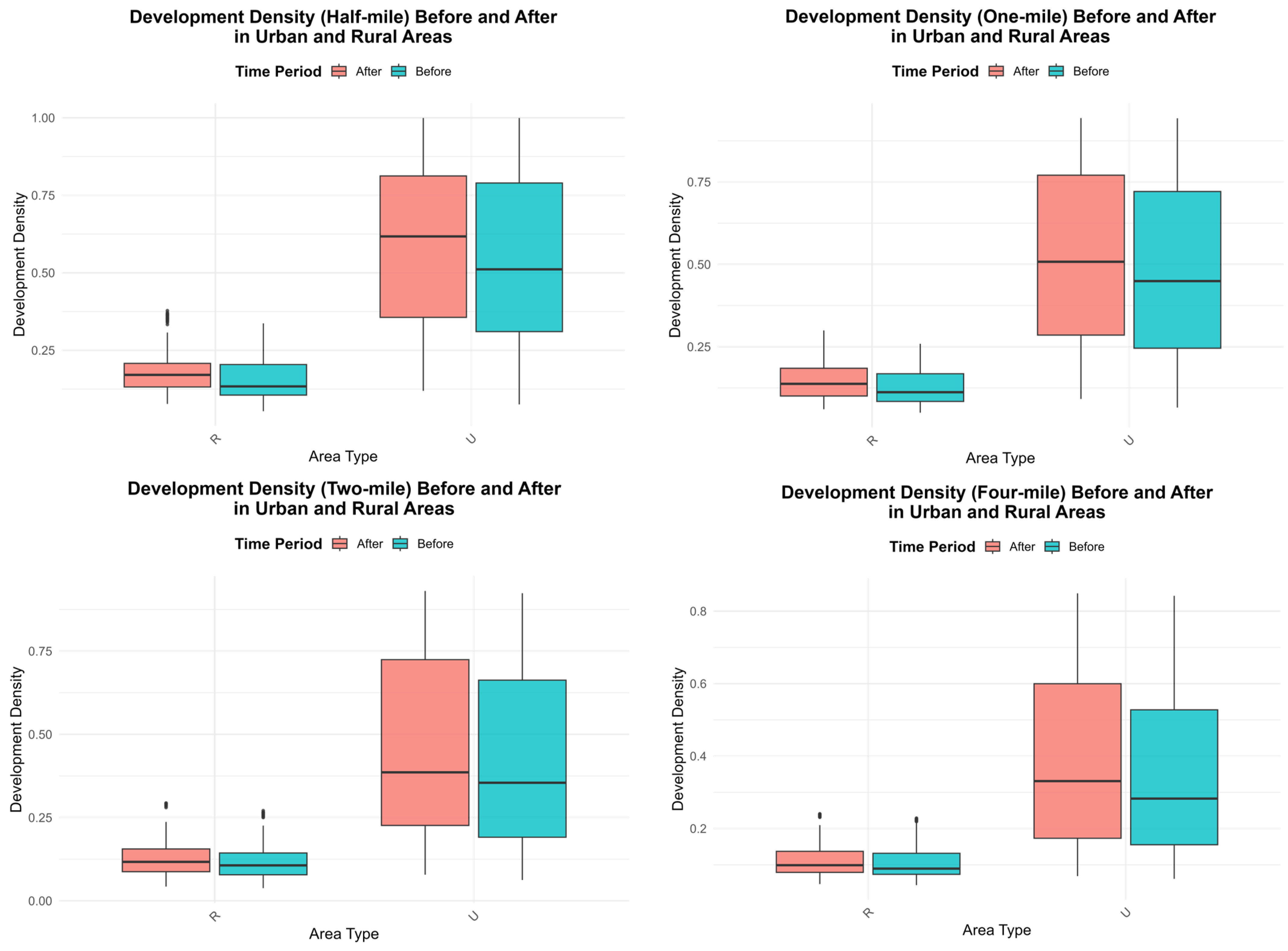
In this research, developed land represents altered landscape (vs. undeveloped land represented by natural land uses), which has specific uses such as roads and other types of infrastructure. This land cover represents four categories: developed open space, developed low Intensity, developed medium Intensity, and developed high Intensity (for the detailed definitions, please refer to the USGS Annual National Land Cover Dataset [NLCD]). Growth of developed land during 1985–2023 represents land use changes (also defined here as land development) during this period, and it is measured in this study by a developed land density (which was computed by dividing the total developed area by the buffer area around each road improvement site) described in detail in the subsection on Land Cover.
Road infrastructure improvement is defined as enhanced traffic vehicle capacity via line widening, construction of a new road, and other improvements in the road infrastructure. In this study, road improvement (interchangeably referred to as the road improvement projects and the study sites) occurred at the sites represented by the segments in the road network that have experienced such improvement. Eighty-four study sites (also referred to as road projects) in total were used in the study. Buffer areas were established around each road improvement site, including 0.5 miles, 1 mile, 2 miles, and 4 miles, to study the effect of the distance on changes in developed land.
Employment density measures economic activity, which influences land use patterns through land conversion into developed (i.e., built-up areas) by stimulating job creation and attracting investment. Employment density was calculated as the total number of jobs by summing all industrial categories divided by the respective buffer area around each road improvement site.
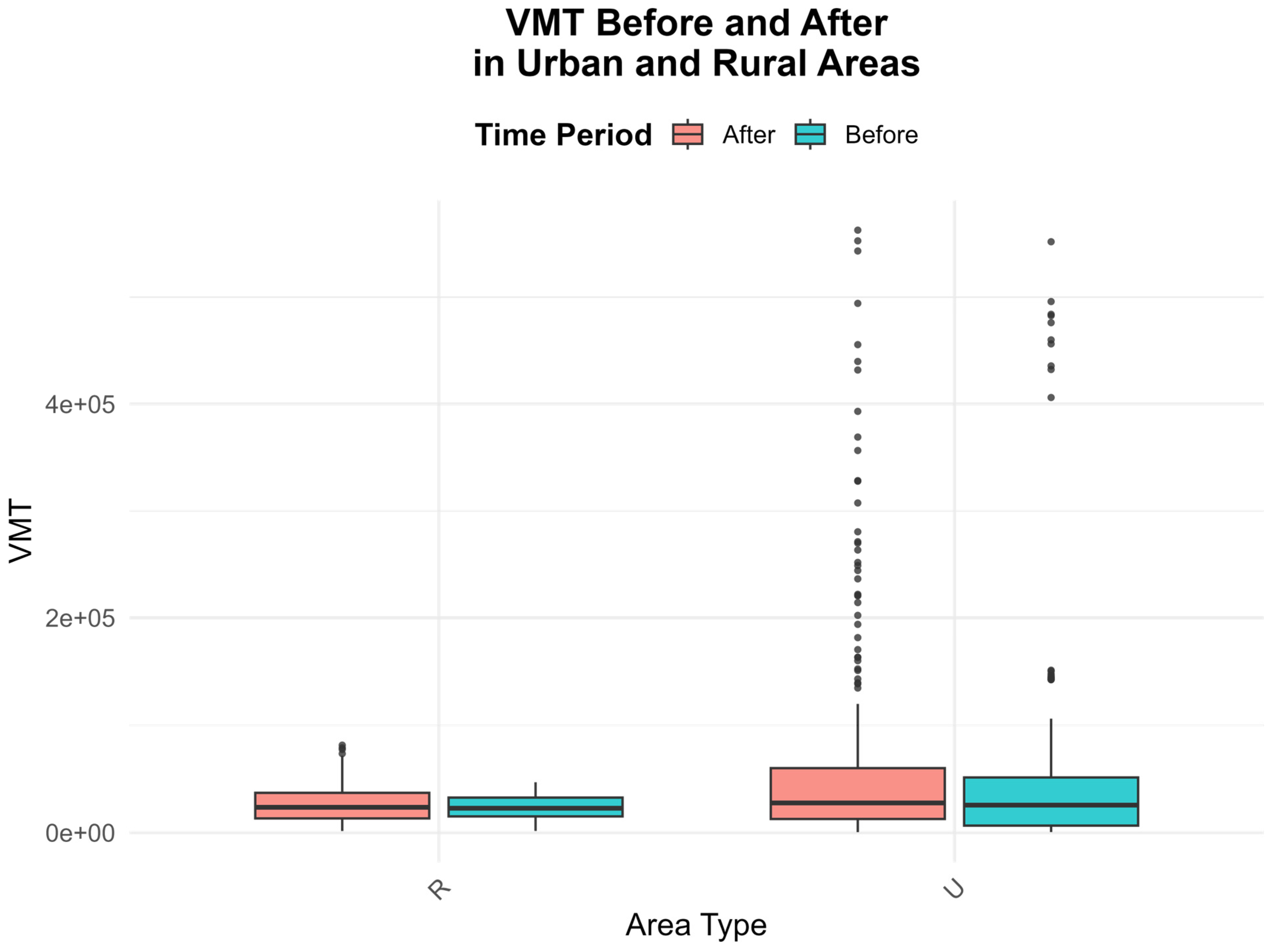
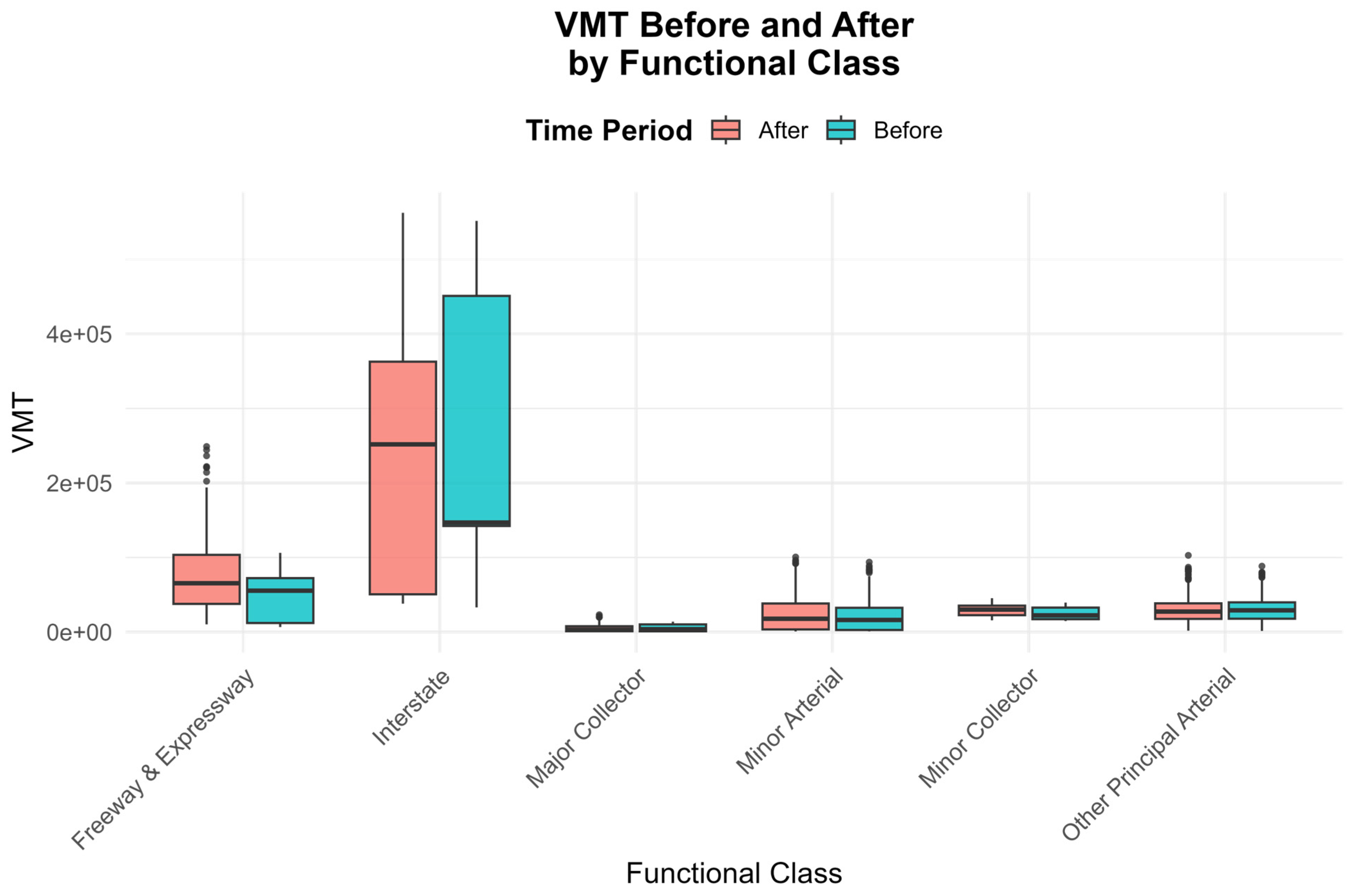
Mobility is proxied by the amount of travel. Increased mobility (i.e., travel demand) due to improvements in road infrastructure (e.g., by adding new roads) can ultimately induce changes in land use patterns. Here, mobility is measured by vehicle miles traveled (VMT) computed by using traffic data (i.e., Annual Average Daily Traffic (AADT) obtained from the Tennessee Traffic Information Management and Evaluation System (TN-TIMES) maintained by the Tennessee Department of Transportation (TDOT). Traffic data were linked with the study sites. A detailed description of the calculation is found in the subsection titled Traffic Data in Data and Data Imputation section.
Rural/urban classification has been used for the identification of the study site location. The rural/urban definitions come from the TN-TIMES classifying if the road is situated in a rural or urban area. A location within urbanized regions defines an area as urban and as rural otherwise.
We utilize real-time traffic data collected before and after the construction of road improvement or development projects and integrate it with employment data in developing a model to estimate the impact of developed land changes in rural and urban areas of Tennessee. The conceptual framework is presented in
Figure 1. Additionally, this research aimed to connect the physical dimensions of transportation infrastructure with the developing metaverse technology, which could redefine this concept by offering experiences in virtual environments. Metaverse technology continuously involves and mixes with various aspects of our day-to-day lives, which makes it extremely important to explore its potential for integration into real-world transportation [
31,
32,
33]. This research examines the case studies of Tennessee road improvement and its relation with developed land growth to provide a comprehensive understanding of the potential challenges and opportunities in emerging virtual real estate.
4. Discussion
Both physical and digital land can be used for various purposes, including land development. Understanding how land is developed in the real world helps one understand how digital land and virtual real estate can grow. One way how physical land can be used and developed is by building various structures and providing and improving infrastructure, both activities are shaped by land use planning and zoning. Within the metaverse, digital land can be “developed” by constructing digital structures and creating virtual economies.
Various factors, including employment, location, utility, engagement potential (e.g., high-traffic areas), and other factors, may shape digital land’s attributes (e.g., its growth, value, etc.). The potential growth of digital land is limitless. Factors like infrastructure or neighborhood amenities affect the characteristics of the physical land and real estate (value, growth). The growing convergence between physical infrastructure and digital twins or metaverse environments offers new avenues for urban planning. Hudson-Smith [
37] argues that immersive digital mirrors of cities could reshape urban planning, while Dembski et al. [
38] and Hassan et al. [
39] highlight the role of digital twins in managing real-world infrastructure through virtual environments.
Gaps exist in prior studies regarding whether changes in land use patterns occur due to road improvements in rural and urban areas and whether these changes are a result of road improvements or natural growth resulting from population increases. We fill this crucial gap by using real-time traffic data in the periods before and after road infrastructure improvement. We develop a model to estimate the extent to which various development factors, including employment, road infrastructure, and locality (rural and urban areas), contribute to land use changes in Tennessee.
Detailed geospatial mapping enables urban designers to create sophisticated virtual replicas of roads, buildings, parks, green spaces, landmarks, and other elements of city infrastructure and topography. Using virtual reality, real-world roads can be made safer, and vice versa.
By bridging both physical and virtual spaces, next-generation services can be provided to residents, including digital shopping complexes, virtual counterparts of city parks and landmarks, and other cultural experiences. Physical developments require foundational infrastructure, such as transportation networks, electrical grids, and telecommunications systems, while virtual developments necessitate digital infrastructure, including hardware, software, network connectivity, and data centers, to function effectively. Virtual developments, like the metaverse, rely on real-time, high-quality, fast, and reliable network connectivity. Here, we examine the relationship between infrastructure development (in this case, roads) and land use change in the physical world, which may help us understand this connection.
5. Conclusions
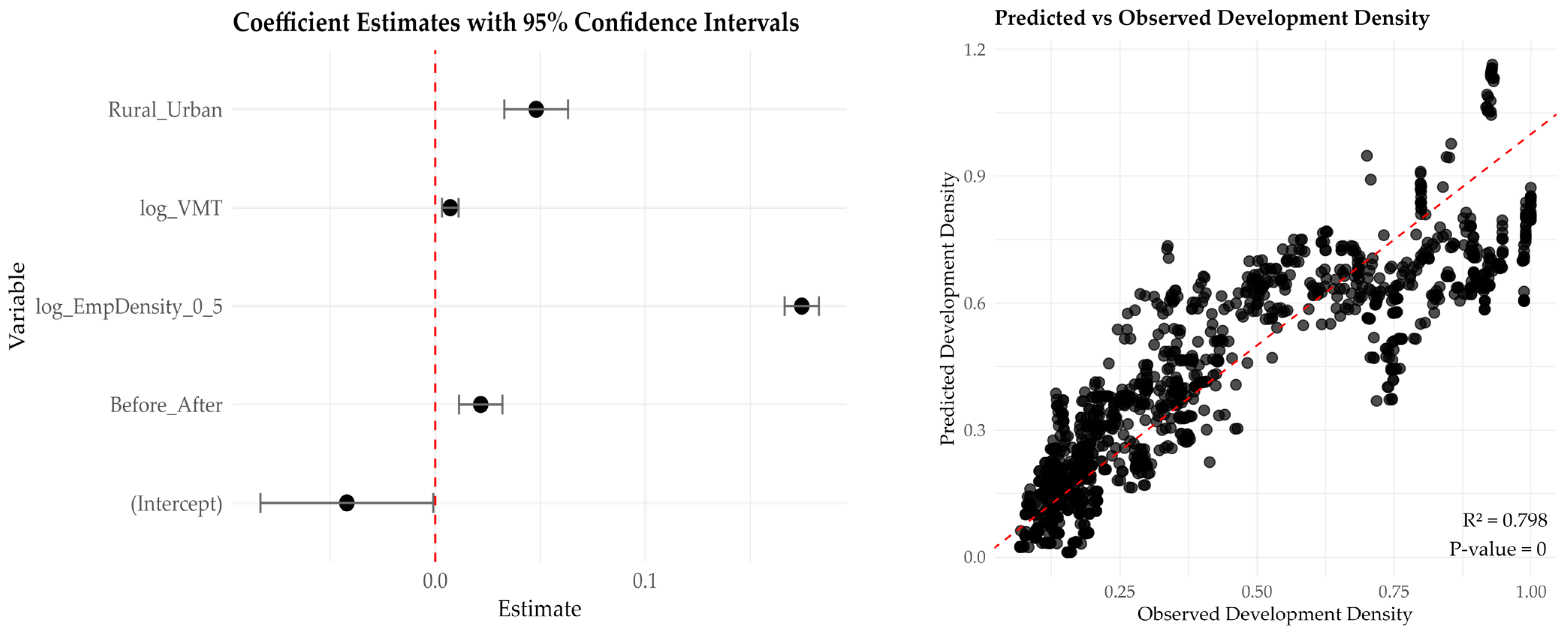
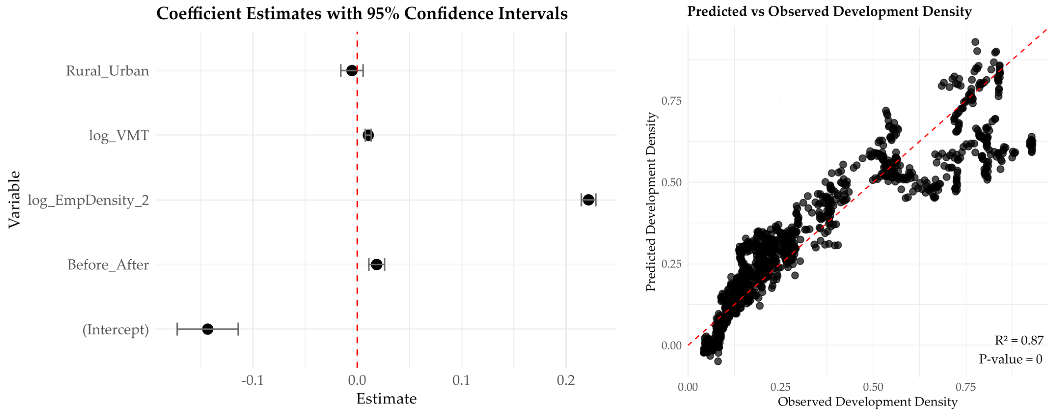
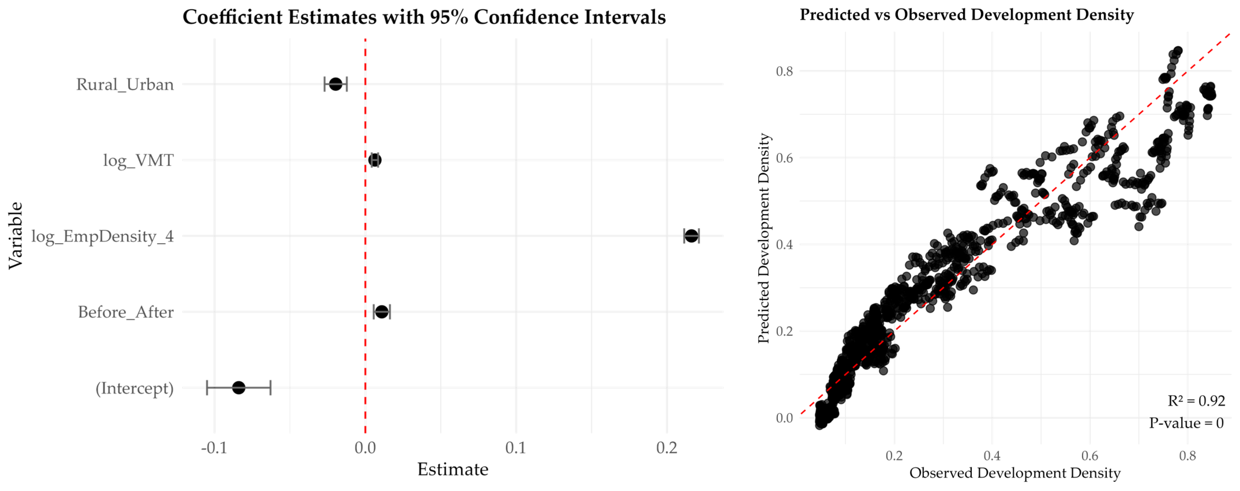
There are vast prospects for the metaverse and virtual real estate. However, the prospective impacts of transportation development in the metaverse have been questioned in this paper. In this paper, we present a case study aimed at enhancing our understanding of the factors influencing land development, including employment, travel volume, road improvements, and urban growth. Developed land (the “development”) was estimated within each buffer zone around the improved road infrastructure (referred to as road projects) and measured in square miles, and subsequently, development density was computed by dividing the total developed area by the respective buffer area over 1985 to 2023. Change in development density enables us to estimate developed land growth (that is, urban growth) for the period of 1985 to 2023.
We find employment the primary predictor of developed land growth. The land development effect of employment stretches well beyond immediate proximity to road infrastructure providing a consistent strong impact over a larger area. Vehicle traffic (measured by VMT) provides a positive and statistically significant effect on land development (measured by development density); however, the land development effect of road infrastructure improvement decreases at broader spatial scales. In our study, it diminishes with increasing distance from the road, resulting in less development in rural areas.
This study has limitations. Data used in this analysis have been taken from the physical world potentially limiting our understanding of the impact of virtual environments on real-world experiences. Future research directions should focus on this impact to improve the quality of life for city residents and examine how metaverse-based principles can be used towards solutions to the problems inherent to urban infrastructure and governance systems of the physical world. One example of the application would be redefining urban landscapes to meet the needs of the emerging digital economy and infrastructure in the near future [
40,
41].
This research is crucial for informing future transportation planning, land-use policies, and sustainable growth strategies. The findings will help policymakers and planners understand how infrastructure changes affect urban expansion, employment accessibility, and regional development, providing valuable insights for future planning and policy development. Specifically, this research raises awareness about the prospects of virtual real estate. Recognizing these prospects of transportation improvement on land development suggests more integration of real-world data integration with the metaverse. Finally, this research bridges the impact of transportation systems, such as changes in travel behavior, employment, and urbanization patterns, with metaverse.


