1. Introduction: Preserving Rural Characteristics
The aims of this study are to identify rural characteristics that persist following extensive urbanization processes that transform villages into towns and cities, and to examine how preservation plans can highlight them. Accordingly, this section explores insights into the preservation of rural characteristics, particularly in villages undergoing urbanization. The review begins with a brief discussion of the changes occurring in rural space. It then focuses on studies addressing the preservation of villages, as well as studies dealing with the preservation of villages undergoing urbanization. The review concludes by highlighting the knowledge gap in the literature regarding the subject of this article and how it addresses it.
All countries and cultures experience changes in the built rural in this era of global urbanization [
1]. The mechanization of agriculture continues to reduce the number of farmers (in the UK, for example, only 1% of the population is employed in agriculture) [
2]. Thus, two processes can be identified. The first and dominant one is the abandonment of villages, particularly by the younger generation seeking the employment and cultural opportunities offered by the city. The second process is the penetration of urban characteristics into villages. Many villagers make a living in non-agricultural work. They commute to nearby towns to work in “urban” occupations and return to their village in the evening, or work in other non-rural occupations in the village. The closer the village is to urban areas, the higher the rate of commuters, and the farther a village is from the nearest city, the more likely it is to be abandoned [
3].
Existing research reveals the penetration of urban characteristics into villages. The occupational change and the fact that the commute from the village to the city has become faster, combined with media advancements that turn the world into a “global village”, contribute to a gradual takeover of rural space by urban forms. Traditional village houses gradually disappear and are replaced by houses influenced by urban architecture. In both China and Turkey, for example, the use of modern, Western construction technologies and an “urban” appearance are considered more advanced and convenient compared to traditional rural construction [
4,
5]. In China, the phenomenon of “urban” concrete houses is particularly prominent along the main roads leading from villages to cities where villagers work and to which they commute [
6]. In Montenegro, Poland, and Lithuania, the transition from a centralized economy during communism to a free-market, globalized one has entailed the repurposing of agricultural lands for construction. Similarly, the originally compact village has expanded in a discontinuous and irregular manner; condos have been built in villages adjacent to towns [
1,
7,
8].
In terms of preserving rural characteristics in the current era, the literature focuses on heritage, combining physical heritage with social and occupational heritage in existing villages undergoing transformation. As a preliminary step, studies addressing preservation justify the need to preserve rural characteristics. According to researchers, although it would appear that the rural landscape is gradually losing its meaning and value due to the abandonment of villages and the decreasing number of people engaged in agriculture, thanks to technological advancements, the village is currently experiencing a renaissance of sorts. Farmlands are used not only for agriculture but also for leisure and heritage purposes—rural landscapes and villages are utilized by eco-tourists and hikers. They possess public value and no longer belong exclusively to landowners [
2]. Moreover, since part of human identity is grounded in cultural landscapes, as defined by UNESCO in 1992 [
9], and since built heritage and landscapes are important historically and as a source of local identification, preserving the rural space is essential [
10].
Based on this understanding, studies have examined various strategies for preserving rural heritage, encompassing both tangible and intangible measures. Wei et al. (2024) outline preservation principles and techniques, emphasizing that if preservation efforts are purely museological, the heritage will cease to exist in practice. They propose a combination of structural preservation—particularly of public buildings—and the continuation of traditional crafts through artisans. This approach is complemented by museum references and an open-ended strategy that seeks to enable modern life within these villages. The idea is to identify values for preservation (rather than just buildings) and adapt them to the present. These include village development, the continuation of life, and craftsmanship in harmony with the environment, which are values that can be maintained today through modern technologies. According to Wei et al., when dealing with tangible heritage, the preservation approach should stem from the values it embodies rather than focusing solely on reconstructing original materials [
11]. Zhou and Chang (2024) emphasize planning strategies that integrate modernization needs with heritage conservation, calling for embedding local heritage into planning processes through collaboration with residents [
12].
Tian and Sun (2015) focus on the architectural scale, recommending the involvement of architects in residential design to ensure that buildings retain vernacular rural characteristics. They argue that architects are likely to be more attuned to conserving the local heritage than homeowners, who often fail to recognize the value of the rural dwellings, viewing them as outdated [
4]. Similarly, Olczak et al. (2022) define the archetypal features of rural houses that should be preserved [
1]. Hofmann et al. (2014) argue for integrating modern materials and innovative construction technologies with traditional materials and local aesthetics to prevent the loss of rural identity in favor of “urban” or foreign-looking buildings. For instance, they propose that steel beams replace wooden ones, or that concrete interior walls be used while maintaining traditional materials for the façade [
13].
A European project sampled 11 countries to preserve the local uniqueness of the villages examined together with their inhabitants’ all-European identity [
14]. The project was motivated by the threats to villages in the continent, as defined by the researchers: in recent decades, youngsters have been moving to the cities to enjoy their employment and cultural opportunities, resulting in the closure of services such as kindergartens, which further encourages abandonment and sociocultural decline [
15]. The need of older adults remaining in the village for amenities that cannot be provided in old villages based on pedestrian traffic also threatens the built tradition. The village may be abandoned by the older generation, or, alternatively, undergo modifications insensitive to its rural character [
16]. Similar to studies mentioned above [
11,
12,
13], this study advocates for the use of new technologies in heritage preservation and highlights sustainable technologies in particular [
17]. With regard to physical preservation, the study recommends strategies for historical physical conservation together with the local community, to reaffirm the commitment to place and community vitality, and touristic cultural events related to the local heritage [
18]. The study also recommends adapting heritage buildings for cultural activities [
19] based on an examination of economic viability and cooperation with the local community [
20]. Finally, it recommends improving abandoned buildings in and around the village center by enlarging and optimizing the open areas so as to attract young families and nursing homes [
15].
However, what about the preservation of physical rural characteristics during massive urbanization processes, expressed not only in the transformation of traditional buildings but also in a significant increase in density and the encroachment of urban uses on agricultural lands? This issue lies at the heart of this article, yet the relevant literature is scarce. Olczak et al. (2022) warn against the construction of multifamily housing or the introduction of non-local vegetation into villages undergoing urbanization [
1]. Beyond this, there is very little research on the preservation of physical rural characteristics during advanced urbanization processes, and there is none, to the best of our knowledge, on rural characteristics that endure even after the village has become a city.
This article addresses this gap by focusing on villages that have already become cities and analyzing the rural characteristics that remain within them. It also addresses the appropriate ways to anchor their preservation in plans. Its significance lies in its forward-looking approach: while most studies addressing rural preservation describe the ongoing urbanization processes or focus on preservation approaches for villages undergoing abandonment, this research reveals the rural elements that remain after urbanization is completed.
Therefore, the first research question is: What are the unique rural physical characteristics that persist for decades, even after extensive and spontaneous urbanization processes occur without any preservation awareness? The second question is: How do contemporary preservation plans highlight rural characteristics after an urbanization process, and how can contemporary preservation plans highlight them better?
2. Materials and Methods
To answer the research questions, the study employs five research methods: case study analysis, systematic historical and geographical review, textual and graphic content analysis of architectural preservation plans, aerial photograph analysis, and experiential analysis of an implemented preservation plan. Apart from the case study and aerial photograph analysis, the methods are qualitative.
At the outset, case studies of villages that transformed into towns and large cities through spontaneous urbanization were selected. These villages were originally founded by Jewish immigrants in a planned manner 100–150 years ago in Palestine, under Ottoman rule, and were called “colonies”. The immigrants arrived in Palestine from Europe for ideological–national reasons and sought to embody their national renewal through planning. Therefore, the planning of Jewish villages was informed by European planned villages that embodied the peak of planning progress in those years.
The choice of these villages as case studies embodies two advantages. First, the villages represent not only themselves but also similar European villages, and therefore, the lessons learned from the former are also relevant to the latter. Specifically, since many planned villages were developed along a main street, the lessons learned from them are relevant to understanding urbanization in vernacular rural villages that developed along main roads. The second advantage is that most of these villages have already completed their urbanization. Therefore, examining their current state, decades after they have been defined as large cities, addresses the first research question, which remains unanswered in the literature. Examining their preservation plans will address the second question, which is also ignored in the literature.
The research methods are implemented in the subsequent sections of the article.
Section 3.1 focuses on the physical characteristics of these villages as a direct result of the ideological approach that guided their planning and the influence of European progress. This section also explains the urbanization process that began decades ago, exploring its causes and physical outcomes. The methodology for this subsection is based on a systematic review of historical and geographical sources.
Section 3.2 examines which rural elements have survived over the decades and whether and how contemporary preservation plans “rediscover” them. At this stage, the research focuses on the specific case study of three major cities that originated as planned Jewish villages in Palestine, to further challenge the question of the preservation of rural characteristics. This is based on the understanding that the larger the city, the more massive the urbanization, and the lower the likelihood of finding rural characteristics within it. Therefore, if rural characteristics are found after all, they are strong features that time has not managed to obscure. To strengthen the analysis, an additional method is used: analysis of contemporary aerial photographs focused on the open spaces that remain in the plots of the former farmyards. This will help answer the question of which rural characteristics have survived urbanization.
In order to identify whether preservation plans address rural characteristics at all, and if so, how they define them, textual content analysis of the preservation plans and graphic content analysis of preservation maps were employed. Specifically, the analysis explored whether the “language” of these plans (1) emphasized objects for preservation (e.g., buildings or trees); (2) designated areas for preservation (e.g., gardens or squares); and (3) identified complexes for preservation (e.g., historical fabric) and/or characteristics for preservation (e.g., sightlines).
The discussion section introduces an additional method: experiential field analysis of an implemented preservation plan conducted through an onsite visit to a specific town that began as a Jewish village in Palestine. This section examines the characteristics and spatial experiences realized through the plan. It also identifies rural features that, while not explicitly stated in the preservation plan, were nevertheless implemented in practice. These features serve as exemplary cases, both for defining the unique rural characteristics that tend to persist even after urbanization and for demonstrating how such features can be effectively incorporated into preservation plans. Through experiential field analysis, the study proposes a new planning “language” that could highlight rural characteristics in dedicated preservation plans. This answers the question of how rural characteristics that survived urbanization should be integrated into contemporary preservation plans.
3. Results
Section 3.1 explains the ideology, precedents, and physical characteristics of the villages that are the focus of this article and explains their urbanization process. This section provides a comprehensive overview of the urbanization process, whereas existing literature on rural preservation focuses only on its initial stages. In addition, this subsection explains the relevance of the case study to planned villages and to European planned villages in particular.
Section 3.2 discusses the content of the preservation plans, their “language”, and the rural characteristics that remain after decades of intense urbanization. This subsection answers the first research question and the first part of the second.
3.1. The Colonies
3.1.1. Progress, European Precedents, and the Physical Form of the Colonies
The case study of this article is the villages established by Jewish immigrants in the final decades of Ottoman rule in Palestine. From 1878 to 1914, 30 such villages were founded, referred to as “colonies” (
moshavot). In the colonies, the settlers—mostly Zionist Jews from Eastern Europe—owned their land, homes, and work tools and made a living as individual farmers. In other words, they were not agricultural laborers who worked on a land not theirs. The colony was planned to house several dozens of families. Most importantly, unlike the vernacular rural settlements that characterized the Arab majority population in Palestine, the colonies had been planned before the Jewish pioneers settled them [
21].
Zionism, the national movement that motivated those Jews to immigrate from Europe to Palestine and settle there as farmers, included several ideological elements, all European in origin. The idea of turning the Jews into productive workers by establishing agricultural villages had originated already in the early 19th century, when the Russian Empire sought to settle Jews and other minorities in its southern peripheries, among other things, to establish its presence there vis-à-vis the Ottoman Empire. The concept of settlement as a means to establish territorial control was the first value inspiring the colonies in Palestine. The second—founding agricultural settlements—was derived from the physiocratic doctrine, which argued that a country’s wealth derived from the number of its inhabitants engaged in primary occupations, i.e., agriculture and crafts [
22]. Zionism relied on these European ideas and the Russian precedent in order to establish territorial control in Palestine in a country perceived as their historical origin [
23].
Whereas the Jewish colonies in Tzarist Russia failed [
24], those in Palestine prospered. Most of them were established by Jewish town-dwellers [
25], who joined settler associations in their European countries of origin [
26]. Emissaries on their behalf searched for appropriate lands to purchase in Palestine, and once found, the colonies were planned. Although rural planning was in its infancy worldwide, the model of the European well-organized village was seen by the Zionists as progressive and thereby in keeping with their ideology of renewing Jewish society through modern settlement practices [
21].
Ben Artzi (1988) [
21] described the colonies’ plans as compact, regular, and homogeneous. This means that many of the colonies were planned along a straight main street, unlike street villages that form along a main road, as is often the case in vernacular settlements [
27]. Other colonies were based on two cross- or T-shaped streets or on an orthogonal grid of streets. The planning of some of the colonies was carried out in collaboration between Templer and Jewish engineers and surveyors. The Templers were devout German Christians who believed that settling in Palestine would hasten the coming of the Messiah and, therefore, established several villages in the country starting in the mid-19th century. Like the Zionists who followed, they too sought to bring European progress to Palestine, and a strong resemblance can be seen between the Templer and Zionist colonies. As part of the progressive urge to improve quality of life, the Zionist colonial settlers’ regulations required them to plant trees in their front yards for the benefit of street users [
21]. To cultivate a healthy and cohesive community, large areas were dedicated to public buildings, including clinics, synagogues, schools, cultural centers, and agricultural factories (such as wineries) [
28].
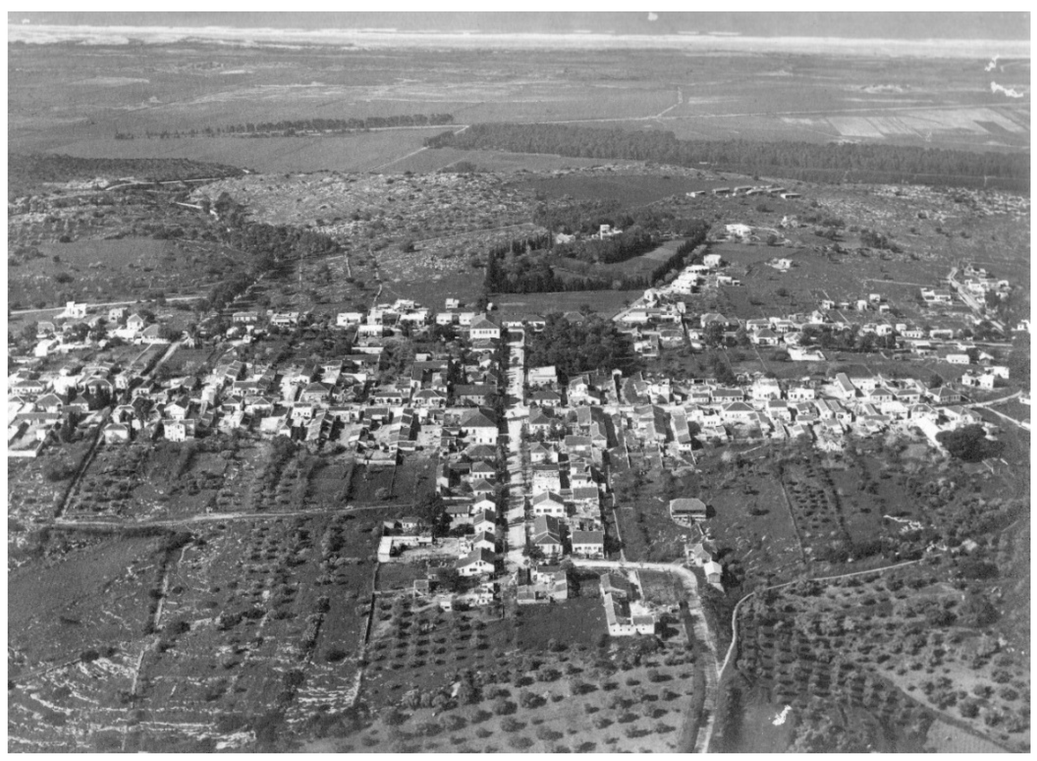
The plots behind the houses, the farmyards, were narrow and elongated, covering an area of a few dunams each (dunam = ~0.25 acres). These plots were used for local consumption and storage (including of farm animals). The fields extended beyond them. The houses, clearly separated from each other, faced the streets, with partitions separating each plot. In some farmyards, a rear wall was built to protect the Jewish settlers [
21]. Thus, the farmyards were accessible from the street, from in-between the houses, as well as from the rear gate, if any (
Figure 1 and
Figure 2).
At the same time, Jews in Palestine also established suburbs and peripheral neighborhoods to improve their quality of life. Since the European ideology of progress was also integrated into these, they were built according to a spacious design of private homes on plots of land [
29], influenced by Howard’s (1965) Garden City theory [
30,
31,
32]. This information, seemingly irrelevant to the villages that underwent urbanization processes, is included here to emphasize that the main difference in spatial experience between garden suburbs and the colonies lies in the long sightlines toward the farmyards, present only in the colonies. This difference became more pronounced during the processes of urbanization
3.1.2. The Colonies’ Urbanization Processes
The urbanization of the garden neighborhoods and suburbs was quite rapid. As the Jewish immigration to Palestine intensified—with many motivated by ideology and many more by fear of antisemitic persecution—multiple-story buildings were built for several families, and the services required by the population expanded to include public, cultural, and commercial services. The largest Jewish city upon the establishment of the State of Israel in 1948, Tel Aviv, started out in 1909 as a small suburb of the mixed Arab-Jewish city of Jaffa. The British, who occupied Palestine in 1918, declared it a city in 1934, after only 25 years [
29]. In 1936, it was home to 150,000 Jews, mostly new immigrants [
33].
The colonies underwent urbanization as well, particularly those in the center of the country, adjacent to Tel Aviv and the Jaffa port, through which the immigrants arrived. The process was similar: the larger the colony became, the greater its inhabitants’ needs, leading to the introduction of non-farming land uses. In the 1920s, garden neighborhoods were built in the colonies for agricultural laborers (not landowners), at a certain distance from the center of the colony [
25]. The demand for land—by both new inhabitants and inheritors—led to the splitting and trading of plots [
21]. A farming industry developed along the edges of the built area (such as storage houses for agricultural goods or canning factories). Subsequently, as the population grew, non-agricultural industry developed as well. In fact, non-agricultural commercial uses penetrated the colonies as early as 1908 [
25]. From the early 1930s to the end of the Second World War, most colonies shifted from agriculture to manufacturing [
28]. Thus, the very first colony, Petach Tikva (est. 1878), was declared by the British as a city in 1937, despite the opposition of its founders, who considered it an offense to their ideology [
34]. At the time, Petach Tikva was home to 11,000 people [
35] (
Figure 3).
Regarding the physical aspect, note that many of the urbanized colonies were planned with an orthogonal street grid, facilitating growth in all directions [
21], and emphasizing the planning similarity to the cities that grew out of the garden suburbs. Moreover, the splitting of the plots in the colonies made their fabric similar to that of the cities growing out of the suburbs, with their dense network of passages [
37].
These processes only intensified after the establishment of the State of Israel and the subsequent immigration wave, which doubled its population within 3 years [
38]. New immigrants were directed to both (former) colonies and (former) garden suburbs that became urbanized and settled in peripheral neighborhoods based on public housing, often at the expense of agricultural lands. In Israel’s second and third decades, the colonies located near the Tel Aviv metropolitan area attracted many from the big cities who looked for cheap housing in a central location. Like them, factories also moved out of the metropolitan center to the edges of the colonies, replacing the agricultural lands. As in every naturally developing city, multiple-story buildings popped up in the developed urban centers [
25].
3.2. The Former Colonies’ Preservation
After the urbanization process is complete, the question is which rural characteristics, if any, have been preserved, and how can they be made accessible to the public? Studies on the preservation of the Jewish colonies in Palestine have focused on two main fields. One is the narrative and ideological field: What are the values of the colonies that should be remembered and commemorated? The other is the material field, which is more pertinent to our purposes here: How can the colonies’ abstract values be represented materially? [
39]. Aharonson (2010) [
40] highlights the importance of preserving technological infrastructures as part of understanding the colonies’ modernization (for example, he emphasizes the importance of the water tower, motorized water pumps, or the school structure that represented the replacement of Jewish-religious education for boys with secular coeducation). Abramovich (2018, 2020) seeks to understand bottom-up changes and therefore analyzes the façades of residential buildings [
41] or the personal construction in the courtyards and agricultural areas using local materials (mostly stone or mud) and methods borrowed from the vernacular Arab construction [
42].
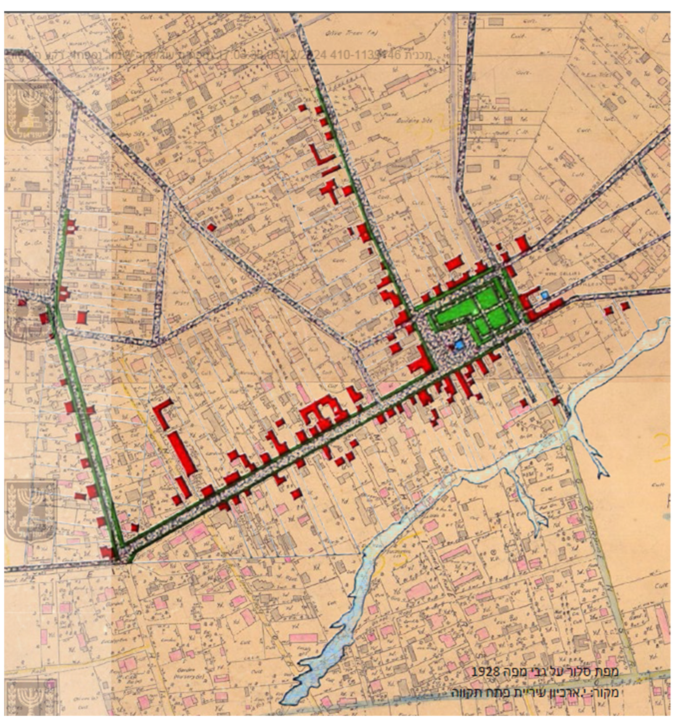
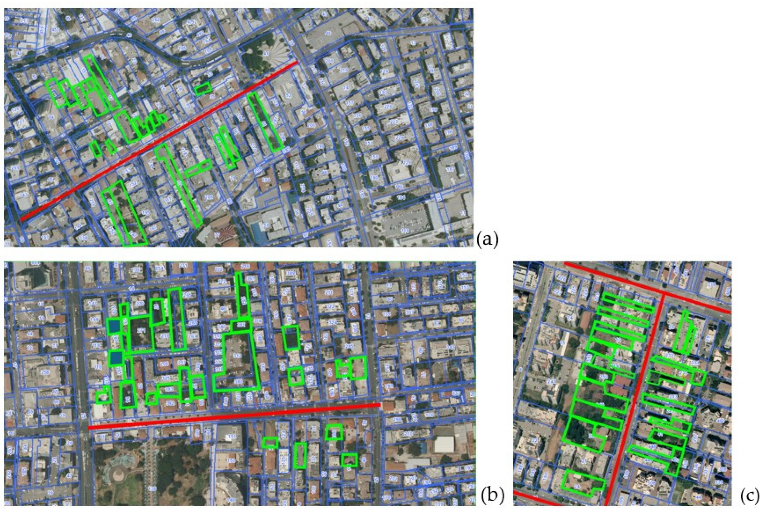
In keeping with the research focus on the preservation of buildings and vegetation, recent preservation plans in the colonies highlight these items. An example is the former colony of Hadera, declared a city in 1952 [
35], 61 years after its founding. The preservation map of the Hadera Urban Master Plan marks specific buildings, trees, and gardens for preservation over a detailed construction map [
43] (
Figure 4).
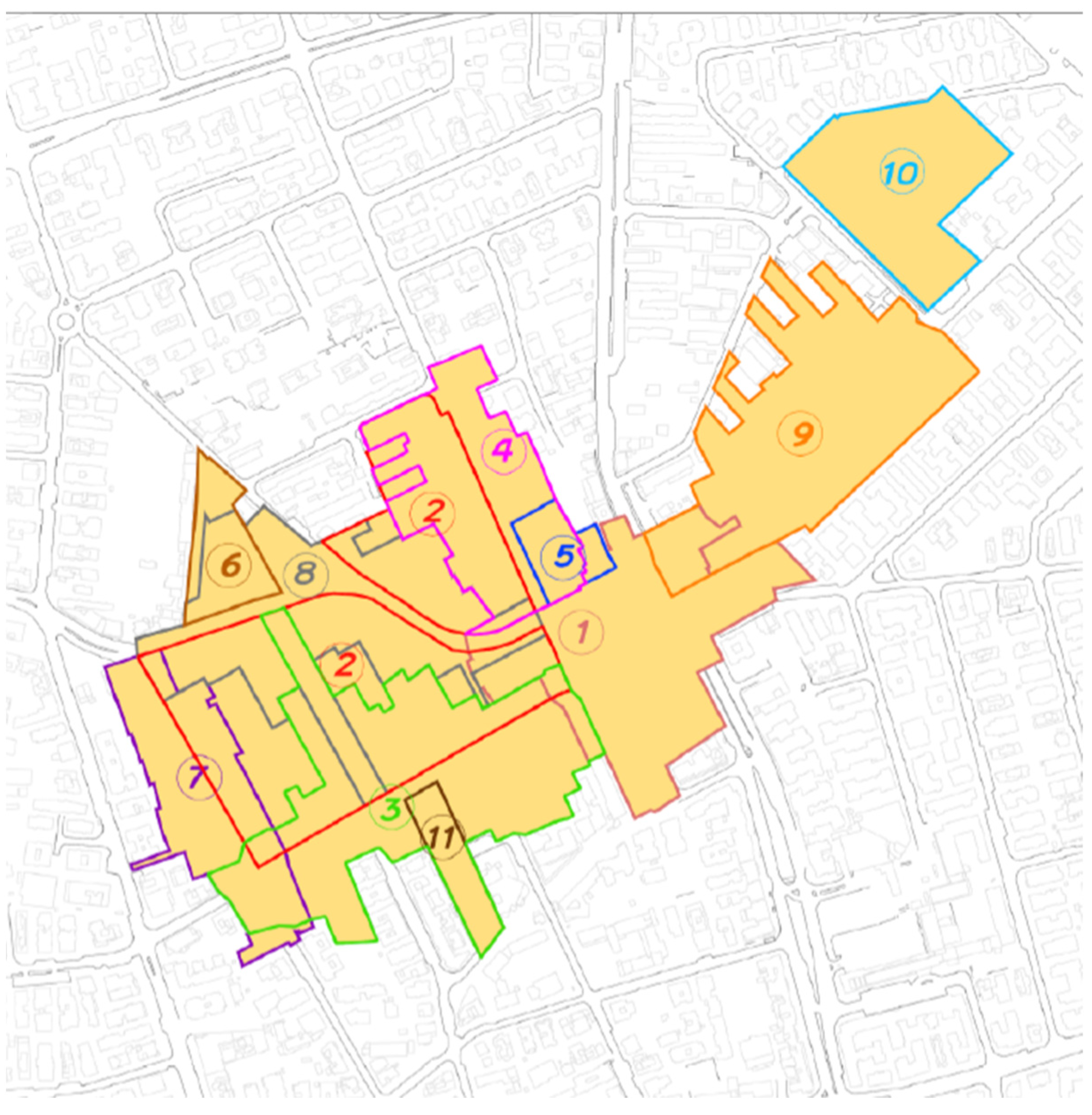
The preservation plan for Rishon LeZion, another major city and former colony, is considered innovative because it focuses on the urban fabric rather than just on specific objects [
44]. The plan dictates that in the core area of the historical colony, the number of stories will be restricted, the contour of the buildings earmarked for preservation will be maintained (to maintain the scale), and plot unification will not be allowed (in order to maintain the scale of the buildings in general, and particularly the spaces between them). The ability to wander from the main street to the farmyards is highly limited. The plan designates only one such courtyard, partially between buildings designated for preservation. Consequently, most of the preservation focuses on the historical buildings along the streets [
45] (
Figure 5 and
Figure 6).
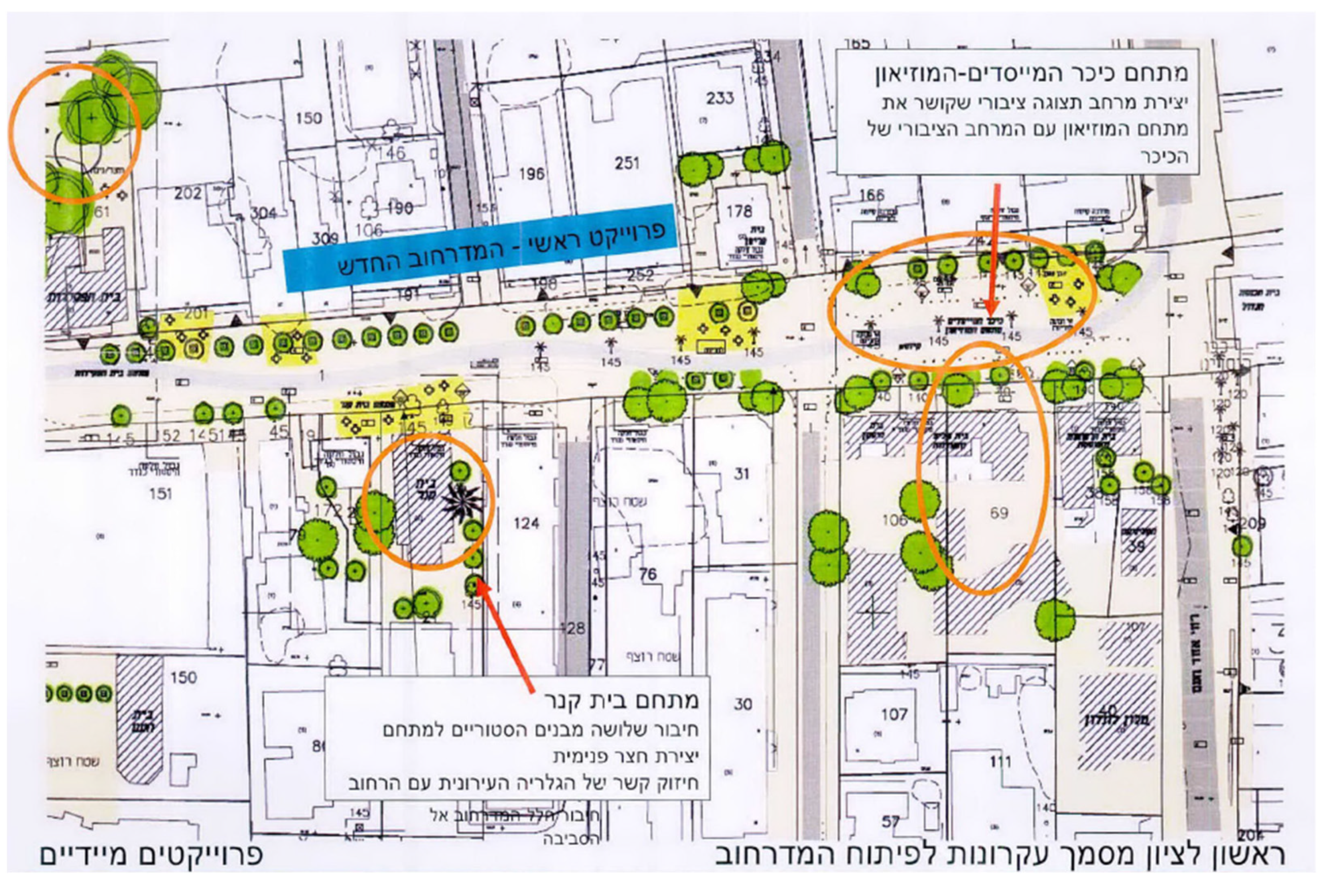
The preservation annex of the 2022 Master Plan for Petach Tikva adds another significant layer to the preservation plans. Beyond the preservation of buildings, trees, and historical fabric, as we have seen in previous plans, the annex identifies the rural uniqueness that is still visible around the main street of the historical colony. The annex identifies open areas that still exist behind the houses and are reminiscent of the private farmyards (
Figure 7). Although they are used for parking today, they do provide a spatial reminder of the place’s rural character, which goes beyond specific buildings and trees. The annex suggests that detailed plans for the areas should focus on “utilizing the open areas in the compound as open public areas in order to expand the open public areas in the center of town” [
46], p. 71; that the trees planted there must be of the same kind planted in the rural colony; and that the lines of sight must be retained. An in-depth look would have discovered the remains of the farmyards in open areas in the maps of Rishon LeZion and Hadera as well (
Figure 8).
To conclude, the detailed case studies reviewed indicate that several old buildings and vegetation have been preserved in the historical core of the city (once a village). The rational planning of the streets and the layout of the old streets have been preserved. The characteristics of a single house on a plot have also been retained. While these are historical features, they are not unique to villages, as these characteristics are also seen in garden neighborhoods and urban suburbs that have also become cities (except for the preservation of agricultural buildings). The unique rural characteristics are the partial preservation of former farmyards (the elongated plots behind the houses on the historical street, as highlighted in
Figure 8) and their partial preservation as open spaces.
The “language” of the preservation plans for the former colonies shifts between identifying specific objects and areas in space and identifying historical fabrics and characteristics. In the preservation map of the Hadera Master Plan, only objects and areas have been identified: buildings, trees, and gardens. Conversely, in the preservation annex of the Rishon LeZion Master Plan, a significant historical fabric is identified, and the plans impose certain prohibitions to preserve it. Finally, in the preservation annex of the Petach Tikva Master Plan, “softer” insights are introduced, focusing on experiential characteristics derived from the physical characteristics, such as encouraging visitors to stroll toward open spaces beyond the historical street and preserving lines of sight. However, there is no information regarding how these areas should be developed to enhance the visitors’ experience.
4. Discussion
In this article, I examine whether there are rural characteristics in villages that have undergone spontaneous urbanization within decades, and how the rural and agricultural heritage of planned villages (colonies) can be preserved. In this case, identifying the characteristics for preservation is a twofold challenge: not only have the colonies become bustling cities long ago, but they are very similar to other urban fabrics of cities that have developed out of garden suburbs and neighborhoods built around the same years. Both are characterized by a regular and dense street grid, relatively small plots, and isolated buildings on each plot (i.e., no continuous construction).
Years after the colonies have become cities, preservation plans identify objects in space (whether old infrastructures, residential or public buildings, or trees), designated areas (such as gardens), or compounds that can be demarcated on the map. These compounds and objects tell the story of the place. However, these characteristics embody historical periods that do not necessarily focus on the agricultural past, as this past was relatively short-lived due to the rapid urbanization process. Furthermore, they do not distinguish the former colony from garden neighborhoods and suburban areas that have evolved into cities. Therefore, the unique, preserved characteristic of the colonies is the farmyards within the historic core; a significant portion thereof remains unbuilt.
To highlight this unique feature, preservation plans must include non-concrete characteristics: lines of sight and movement. This includes the continuous line of sight from the street to the house and the longer line of sight from the street to the farmyard, as well as the movement from the street to the farmyard. Both are inherent to the colony, as farmyards could be accessed both from the street and from the back through the fields and plantations along the built perimeter. Maintaining the lines of sight and preserving these areas as open areas visible from the street will encourage strolling from the street inwards and back (as it used to be in the village), and thus maintain the experience of visibility and movement, enriching the preservation project.
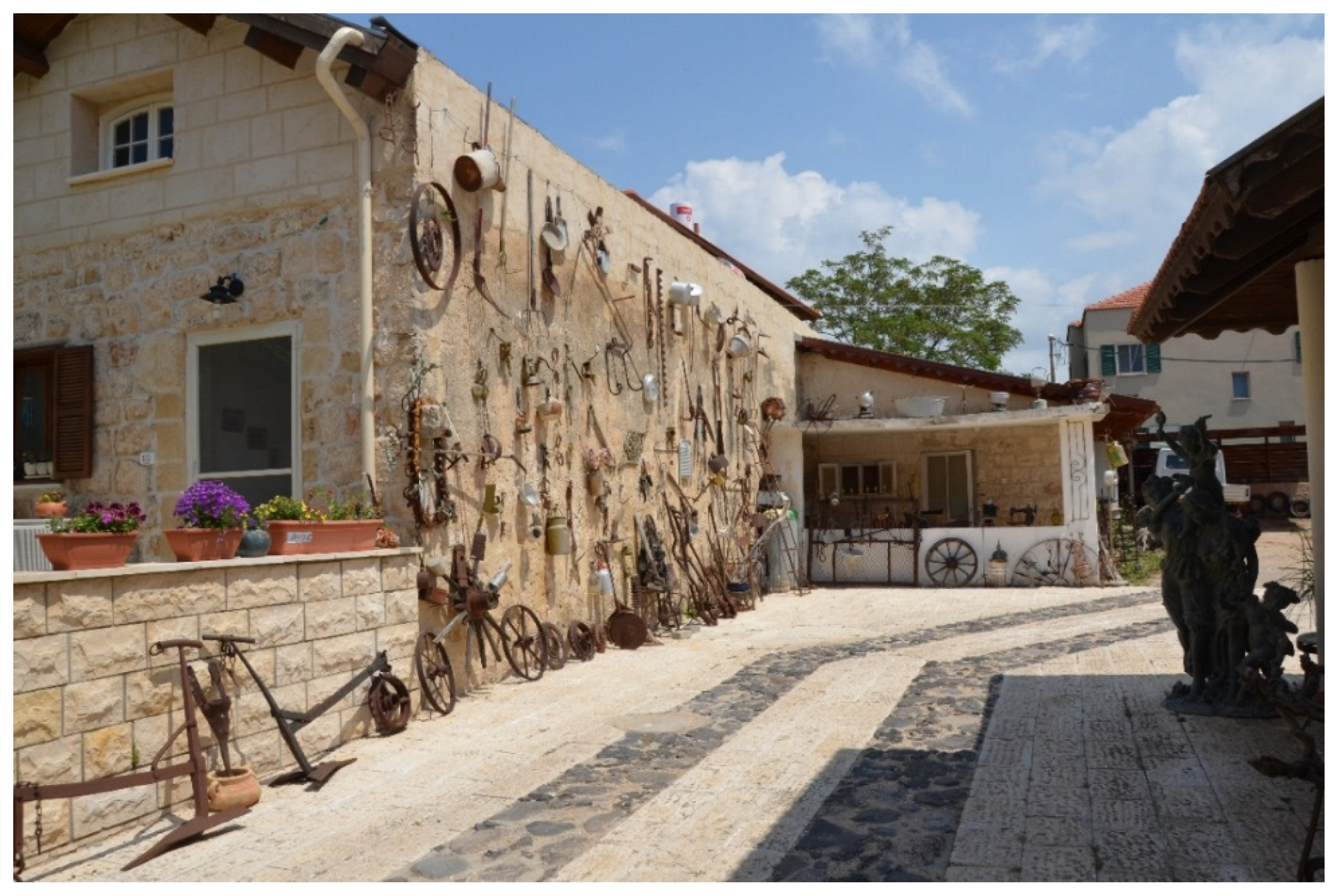
An example of preserving these characteristics may be seen in Zikhron Ya’akov. This former colony, whose relative distance from central Israel helped protect it from excessive urbanization, retained its main street, including the lines of sight and movement toward the farmyards. In some cases, the agricultural buildings and walking access to them were preserved and even developed. Consequently, the touristic experience is enhanced, as are the local economy and pride [
47] (
Figure 9,
Figure 10,
Figure 11 and
Figure 12).
Note that preserving the open areas behind buildings does not necessarily entail developing them as gardens and certainly not as a single, continuous compound. In Zikhron Ya’akov, some of the yards now open for strolling are paved identically to the street pavement (see
Figure 11). In doing so, the architects matched the strolling experience to that of the lines of sight: both are continuous from the street inwards and back (and not as a single continuous garden that unites all farmyards). The public’s movement from the street into the farmyards echoes the movement of the colony’s founders. Thus, the correct identification of the rural characteristics that remain after massive urbanization processes—including the farmyards and sightlines and free movement toward them, as well as appropriate architectural and landscape treatment—could help revive the memory of the rural heritage, even when the village has become a city.
5. Conclusions
This study aimed to fill the existing knowledge gap regarding the rural characteristics that remain after decades of massive urbanization processes and to examine how they can be made accessible to the public through preservation plans. The case study of Jewish villages in Ottoman Palestine that became cities in Israel through rapid and spontaneous processes indicates that their uniqueness lies in the preservation of farmyards behind the houses in the historical core. Even when urban uses came to predominate in the villages, new residential buildings were built on agricultural land, farmyards were divided and sold, and the architecture of the houses changed. Many farmyards remained unbuilt, preserving the original plot division. These characteristics are unique to villages (as opposed to garden neighborhoods or suburbs), given their agricultural component.
Recent preservation plans focus on preserving physical, historical objects and areas, such as buildings, trees, public spaces, or the historical fabric. Preserving these as historical evidence is obviously significant. However, they are not unique to rural heritage preservation, as they can also be found in garden neighborhoods. The preservation of non-concrete characteristics, such as views and movements, from the historical street to the façades and from the street to the farmyards behind the houses, is unique to cities that started out as agricultural villages. Therefore, future preservation plans should preserve these characteristics and encourage movement toward the former farmyards by opening courtyards, designing continuous street and courtyard pavements, and identifying attractive functions in the farmyards. The more these functions are rural (e.g., a restaurant based on agricultural products or a shop selling local produce), and the more the landscape design aligns with historical rural values, the better.
Future studies may explore the remnants of rural heritage in the urbanization processes of villages characterized by typologies different from those examined here, including villages whose residents belong to diverse cultures. For instance, studies may investigate vernacular typologies such as circular village forms or kasbah-like settlements, as well as indigenous or other immigrant cultures. Further research may also address the tension between urbanization and conservation, as reflected in contemporary conservation discourse and conservation planning within ongoing urbanization processes, where heritage values are recognized and supported by UNESCO. Finally, future studies can analyze the “languages” of conservation expressed in different planning approaches and assess variations between the conservation discourses of different countries and cultures. Such research would bridge the knowledge gap left by the present study, which, due to its limited scope, has focused on the geographically, culturally, and ideologically specific case of planned villages whose urbanization has been completed.


