Monitoring Fast-Growing Megacities in Emerging Countries Through the PS-InSAR Technique: The Case of Addis Ababa, Ethiopia
Abstract
1. Introduction
- Seismic Risk: Subsidence maps refine seismic hazard models by identifying overlaps with faults or liquefaction-prone zones, guiding retrofitting of critical infrastructure.
- Urban Planning: Results support zoning policies that limit high-density construction in subsidence-prone areas, reducing future damage.
- Groundwater Management: If linked to subsidence, findings can inform regulations on extraction and promote alternative water sources.
- Early Warning: Sentinel-1 displacement trends enable predictive models for gradual subsidence, supporting timely interventions.
- Scalable Model: The PSI-based method offers a low-cost, replicable framework for monitoring in data-scarce cities across the Global South.
2. Materials and Methods
2.1. Study Area
2.2. Interferometric Data and Processing Approach
2.2.1. Ground and Satellite Data
- C-band. This band operates at wavelengths around 5.6 cm and is suitable for a wide range of applications due to its balanced performance in terms of spatial resolution and penetration capability. It offers moderate resolution and can penetrate vegetation to some extent, making it useful for monitoring agriculture, forestry, and land cover changes.
- X-band. With shorter wavelengths around 3 cm, X-band SAR data provide high spatial resolution imagery. This band is particularly beneficial for applications requiring fine details, such as urban monitoring, infrastructure analysis, and disaster management. However, X-band SAR has limited penetration capabilities compared to lower frequency bands.
- L-band. L-band SAR data operate at longer wavelengths (around 23.6 cm). They offer excellent penetration capabilities through vegetation and soil, making them valuable for applications like forest monitoring, agriculture, and subsidence monitoring. Although L-band SAR provides coarser spatial resolution compared to X-band, its ability to penetrate through vegetation can be advantageous for certain applications.
2.2.2. PSI Technique
2.2.3. PSI Workflow Diagram
- Generation of a connection graph;
- Definition of the area of interest;
- Interferometric Workflow: co-registration, creation and flattening of interferograms, and development of mean power image and amplitude dispersion index (MuSigma) (input: DEM and GCPs);
- Inversion First Step: estimation of coherence, velocity, and residual topography;
- Second Inversion Step: elimination of atmosphere patterns, estimation of coherence, velocity, and residual topography, and estimation of displacement component (input: GCPs);
- Geocoding: velocity, precision result geocoding, and displacement geocoding (input: DEM).
3. Results
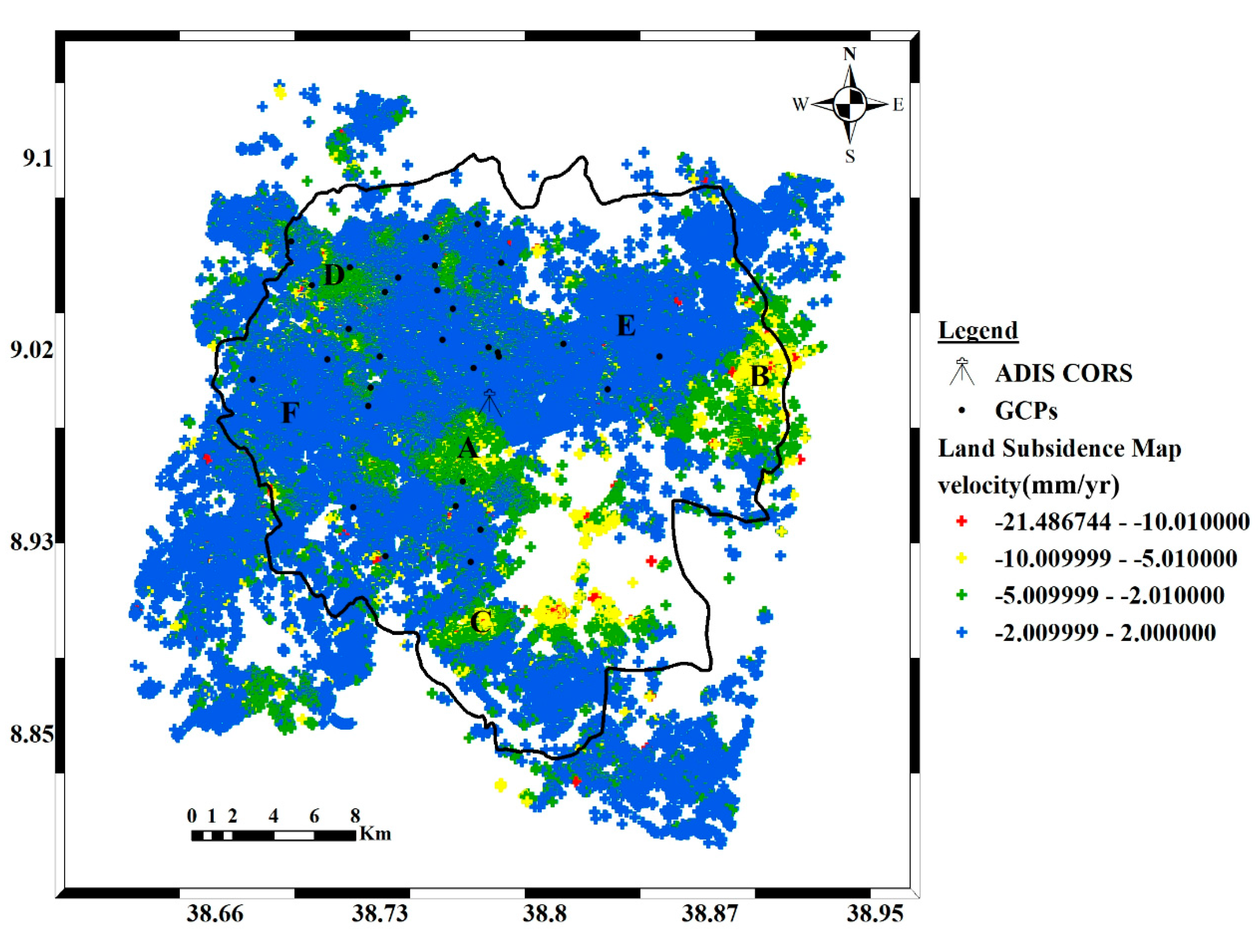
3.1. PS Velocity Map
- -
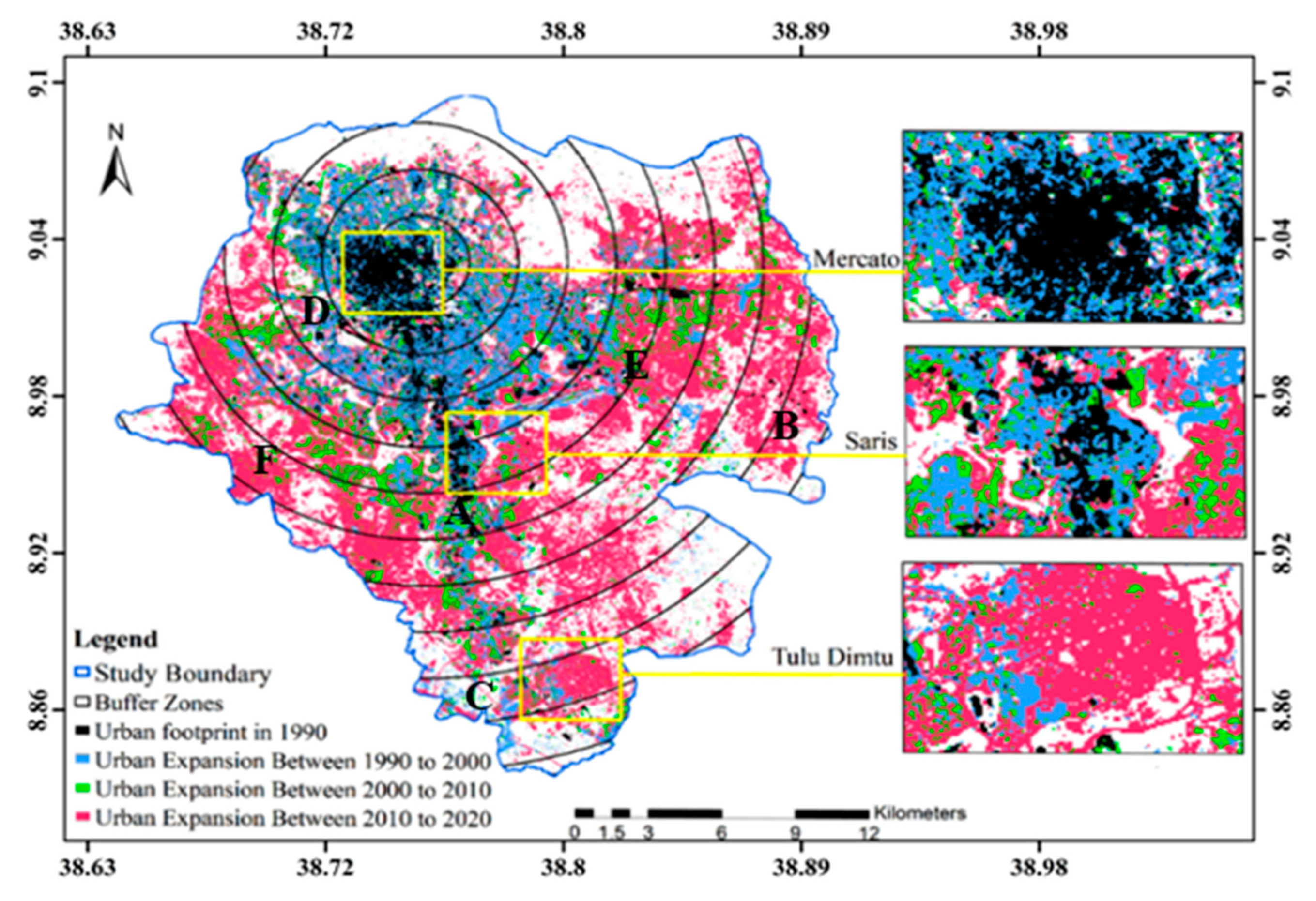
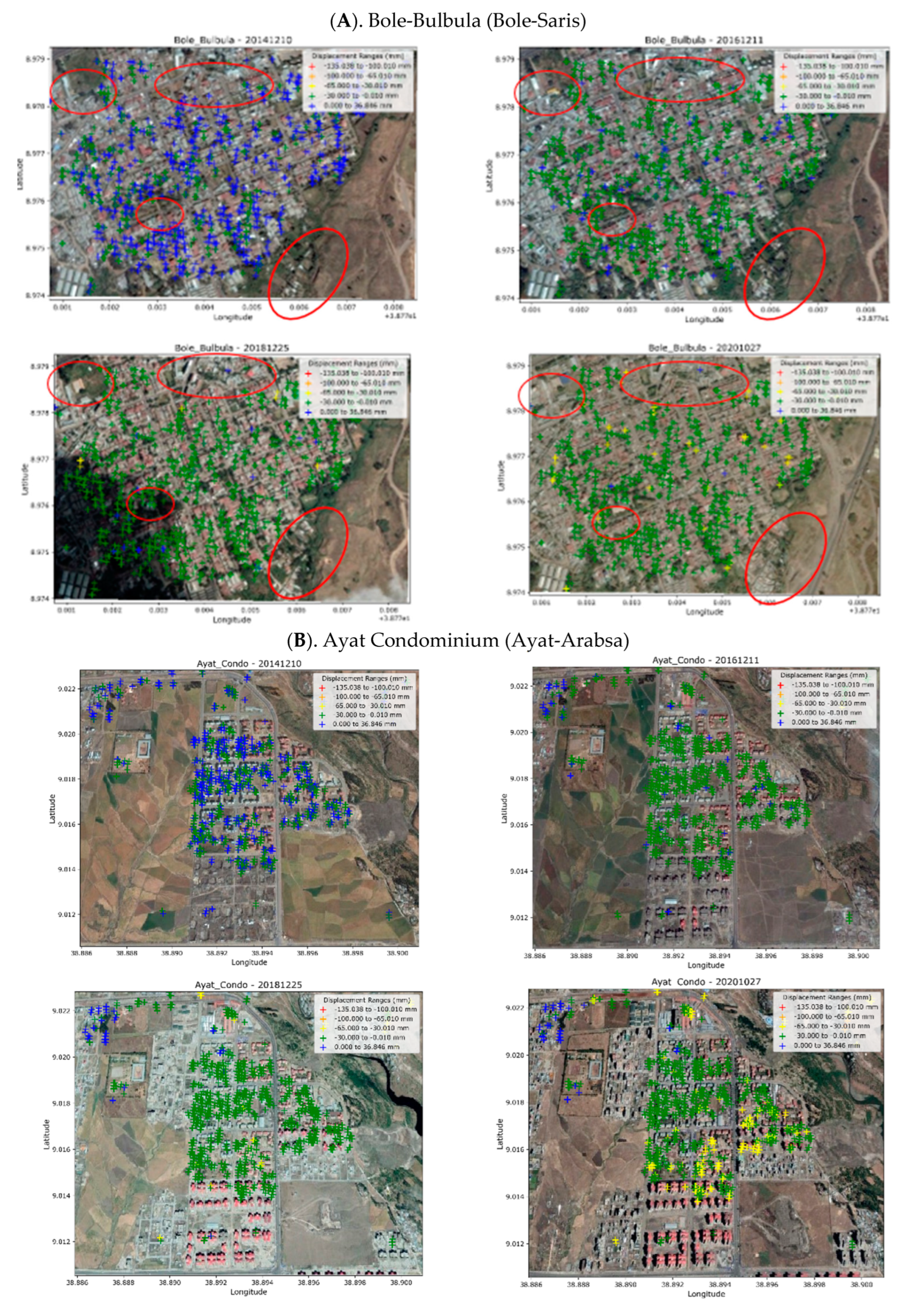
- Bole-Saris (A): The Bole-Saris area has experienced intense urbanization since 2015, with the construction of new residential buildings and malls, especially in Bole-Bulbula village, as shown in the Figure. The district has become highly urbanized, characterized by tall buildings and dense road networks. The subsidence in this area is likely due to soil compaction caused by the construction activities and the extraction of groundwater for potable water to support the growing population and urban development. The increased ground deformation in Bole-Saris is primarily attributed to the presence of thick soil layers, as well as the intense urbanization and the construction of tall buildings which have accelerated land subsidence in the area. The magnitude of displacements increases both spatially and temporally in response to the rising anthropogenic pressure. On average, cumulative deformations of up to 30 mm are observed, with maximum values reaching 65 mm.
- -
- Ayat-Arabsa (B): The Ayat-Arabsa area has also experienced significant urbanization, particularly in the center of Ayat’s real state and condominium village, as shown in the Figure. The construction of new settlements and high-rise buildings has been prominent since 2015. Similar to Bole-Saris, the subsidence in Ayat-Arabsa is likely caused by soil compaction resulting from the loads imposed by new buildings and excessive groundwater extraction to meet the demands of growing urbanization and population needs. The areas experiencing subsidence in Ayat-Arabsa are primarily located in the new settlements and sectors with high-rise buildings. In this sector as well, displacements have increased both spatially and temporally, corresponding to the expansion of the urbanized area. Average displacements of up to approximately 30 mm are observed, while in the central portion, the most impacted by urbanization, they can reach up to 65 mm.
- -
- Akaki-Kality (C): The Akaki-Kality areas have experienced significant urban development and high-rise building construction since 2015. The intense urbanization, industrial activity, dense road networks, soil compaction from new buildings, and substantial groundwater exploitation in this area have caused significant subsidence, as seen near landmarks such as the Heineken Brewery SC around Kilinto. Displacements have been particularly intense during the final years of the observation period, ranging between 30 and 60 mm, and have been affecting both older and more recent buildings.
- -
- Atena-Tera (D): In this area, a rapid increase in anthropogenic pressure has also occurred since 2015. This increase has been accompanied by a rise in surface deformations, with displacement values reaching up to 30 mm across the entire study area (Figure 6D). The observed land subsidence can be attributed to soil compaction caused by urban development and the construction of high-rise buildings. Additionally, the high thickness of surface soils has further intensified the subsidence process.
3.2. Displacement Time Series
- -
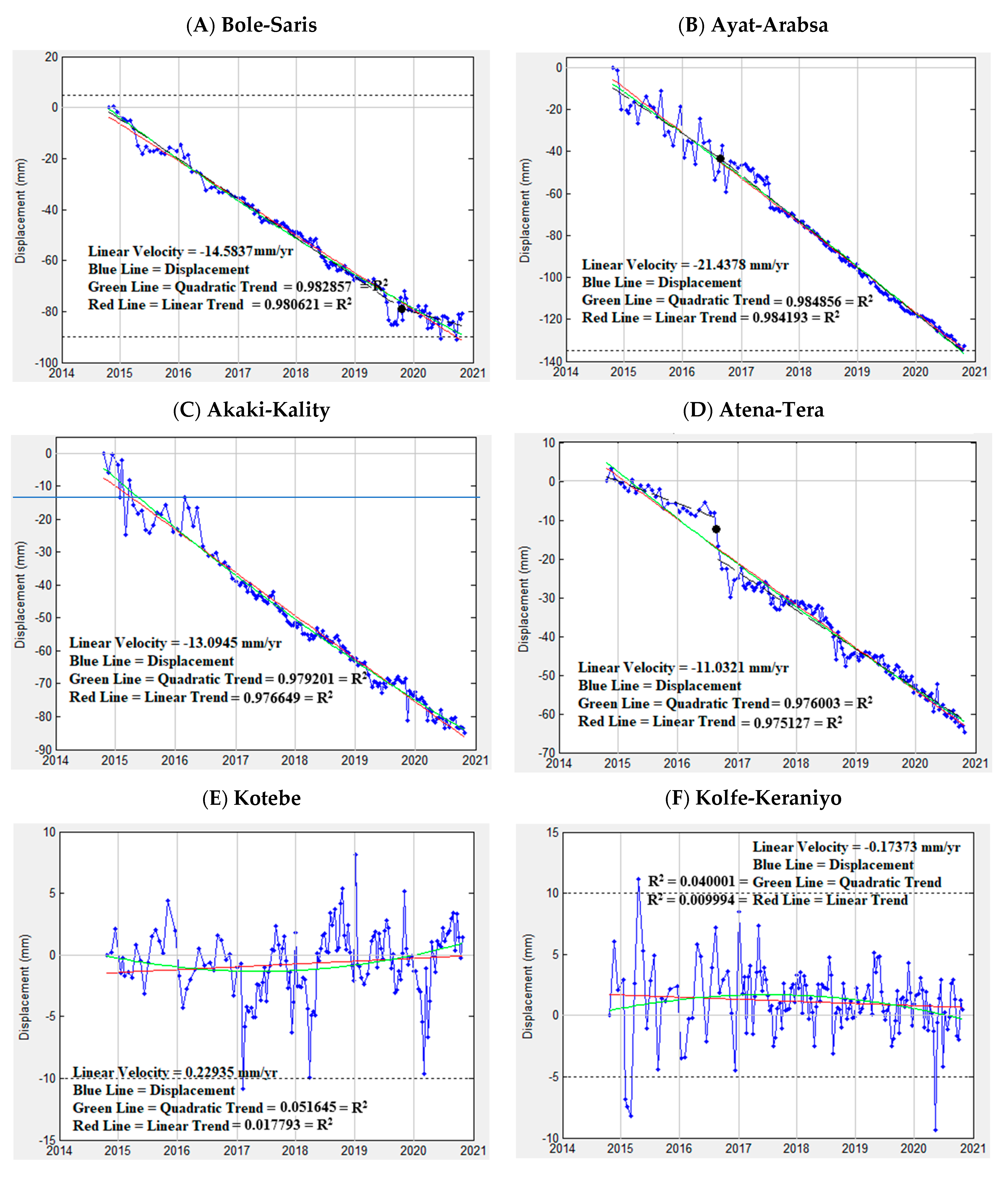
- Linear (Increase or Decrease): In some areas, the displacement time series follows a linear pattern from 2017 to 2021 (Figure 7A–D), showing either a steady increase or a decrease in vertical displacement over time. A linear trend may indicate gradual, constant subsidence or uplift in the region.
- -
- Bilinear (Increase, Decrease, or Vice Versa): A bilinear pattern indicates two distinct linear trends in the displacement time series, which may occur in opposite directions. This suggests a change in the subsidence or uplift rate during the observation period. For example, the subsidence rate might increase or decrease abruptly at a specific point in time, as observed in Figure 7C,D between 2016 and 2017.
- -
- Quadratic (Increase or Decrease): A quadratic pattern suggests a nonlinear trend in the displacement time series, indicating that the subsidence or uplift is either accelerating or decelerating over time. The rate of displacement changes nonlinearly, resulting in a curved trend, as observed in Figure 7C,D from 2014 to 2017.
- -
- Uncorrelated (Stable area): In the stable areas (Figure 7E,F), the displacement time series does not exhibit any significant pattern or trend over time. The vertical displacements appear uncorrelated, indicating that the ground remains relatively stable, with no notable subsidence or uplift.
4. Discussion
5. Conclusions
Author Contributions
Funding
Data Availability Statement
Acknowledgments
Conflicts of Interest
References
- Galloway, D.L.; Burbey, T.J. Review: Regional land subsidence accompanying groundwater extraction. Hydrogeol. J. 2011, 19, 1459–1486. [Google Scholar] [CrossRef]
- Land Subsidence Is One of the World’s Underrated Problems. Deltares. 24 December 2021. Available online: https://www.deltares.nl/en/topdossiers/subsidence/ (accessed on 15 March 2024).
- Kurz, T.; Gloaguen, R.; Ebinger, C.; Casey, M.; Abebe, B. Deformation distribution and type in the MER: A remote sensing study. J. Afr. Ear. Sci. 2007, 48, 100–114. [Google Scholar] [CrossRef]
- Agostini, A.; Bonini, M.; Corti, G.; Sani, F.; Manetti, P. Distribution of Quaternary deformation in the central Main Ethiopian Rift, East Africa. Tectonics 2011, 30, 1–21. [Google Scholar] [CrossRef]
- Navarro-Hernández, M.I.; Tomás, R.; Lopez-Sanchez, J.M.; Cárdenas-Tristán, A.; Mallorquí, J.J. Spatial Analysis of Land Subsidence in the San Luis Potosi Valley Induced by Aquifer Overexploitation Using the Coherent Pixels Technique (CPT) and Sentinel-1 InSAR Observation. Remote Sens. 2020, 12, 3822. [Google Scholar] [CrossRef]
- UN-Habitat. Addis Ababa Urban Profile: Sustainable Urban Development and Housing; United Nations Human Settlements Programme: Nairobi, Kenya, 2017. [Google Scholar]
- Gebre, Y.; Gebremariam, K. Urban Sprawl and Infrastructure Development in Addis Ababa: Challenges and Opportunities. J. Urban Dev. Stud. 2020, 12, 45–60. [Google Scholar]
- World Bank. Ethiopia Urbanization Review: Urban Institutions for a Middle-Income Ethiopia; World Bank Group: Washington, DC, USA, 2015. [Google Scholar]
- Bovenga, F.; Wasowski, J.; Nitti, D.O.; Nutricato, R.; Chiaradia, M.T. Using COSMO-SkyMed X-band and ENVISAT C band SAR interferometry for landslides analysis. Remote Sens. Environ. 2012, 119, 272–285. [Google Scholar] [CrossRef]
- García-Davalillo, J.C.; Herrera, G.; Notti, D.; Strozzi, T.; Álvarez-Fernández, I. DInSAR analysis of ALOS PALSAR images for the assessment of very slow landslides: The Tena Valley case study. Landslides 2014, 11, 225–246. [Google Scholar] [CrossRef]
- Ma, P.; Cui, Y.; Wang, W.; Lin, H.; Zhang, Y.; Zheng, Y. Landslide Movement Monitoring with InSAR Technologies. In Landslides; Zhang, Y., Cheng, Q., Eds.; IntechOpen: Rijeka, Croatia, 2022. [Google Scholar] [CrossRef]
- Mohsen, P.; Ali, M.; Saied, P.; Reza, D. Monitoring of Maskun landslide and determining its quantitative relationship to different climatic conditions using D-InSAR and PSI techniques. Geomat. Nat. Hazards Risk 2022, 13, 1134–1153. [Google Scholar] [CrossRef]
- Bell, J.W.; Amelung, F.; Ferretti, A.; Bianchi, M.; Novali, F. Permanent scatterer InSAR reveals seasonal and long-term aquifer-system response to groundwater pumping and artificial recharge. Water Resour. Res. 2008, 44, W02407. [Google Scholar] [CrossRef]
- Heleno, S.I.N.; Oliveira, L.G.S.; Henriques, M.J.; Falcão, A.P.; Lima, J.N.P.; Cooksley, G.; Ferretti, A.; Fonseca, A.M.; Lobo-Ferreira, J.P.; Fonseca, J.F.B.D. Persistent Scatterers Interferometry detects and measures ground subsidence in Lisbon. Remote Sens. Environ. 2011, 115, 2152–2167. [Google Scholar] [CrossRef]
- Rafiei, F.; Gharechelou, S.; Golian, S.; Johnson, B.A. Aquifer and Land Subsidence Interaction Assessment Using Sentinel-1 Data and DInSAR Technique. ISPRS Int. J. Geo-Inf. 2022, 11, 495. [Google Scholar] [CrossRef]
- Xiao, B.; Zhao, J.; Li, D.; Zhao, Z.; Xi, W.; Zhou, D. The Monitoring and Analysis of Land Subsidence in Kunming (China) Supported by Time Series InSAR. Sustainability 2022, 14, 12387. [Google Scholar] [CrossRef]
- Shi, L.; Gong, H.; Chen, B.; Shao, Z.; Zhou, C. Land subsidence simulation considering groundwater and compressible layers based on an improved machine learning method. J. Hydrol. 2025, 656, 133008. [Google Scholar] [CrossRef]
- Othman, L.S.; Majidi, J.; Amini, A. Land Subsidence Assessment in the Darab Plain, Fars Province, Iran: Integrating Sentinel-1 InSAR and Groundwater Level Data. Adv. Civ. Eng. Environ. Sci. 2025, 2, 57–61. [Google Scholar] [CrossRef]
- Jung, H.; Kim, S.; Jung, H.; Min, K.; Won, J. Satellite observation of coal mining subsidence by permanent scatterer analysis. Eng. Geol. 2007, 92, 1–13. [Google Scholar] [CrossRef]
- Escayo, J.; Marzan, I.; Martí, D.; Tornos, F.; Farci, A.; Schimmel, M.; Carbonell, R.; Fernández, J. Radar Interferometry as a Monitoring Tool for an Active Mining Area Using Sentinel-1 C-Band Data, Case Study of Riotinto Mine. Remote Sens. 2022, 14, 3061. [Google Scholar] [CrossRef]
- Soni, R.; Alam, M.S.; Vishwakarma, G.K. Prediction of InSAR deformation time-series using improved LSTM Deep Learning Model. Sci. Rep. 2025, 15, 5333. [Google Scholar] [CrossRef] [PubMed]
- Vallone, P.; Giammarinaro, M.S.; Crosetto, M.; Agudo, M.; Biescas, E. Ground motion phenomena in Caltanissetta (Italy) investigated by InSAR and geological data integration. Eng. Geol. 2008, 98, 144–155. [Google Scholar] [CrossRef]
- Cigna, F.; Osmanoglu, B.; Cabral-Cano, E.; Dixon, T.H.; Ávila-Olivera, J.A.; Garduño-Monroy, V.H.; DeMets, C.; Wdowinski, S. Monitoring land subsidence and its induced geological hazard with Synthetic Aperture Radar Interferometry: A case study in Morelia, Mexico. Remote Sens. Environ. 2012, 117, 146–161. [Google Scholar] [CrossRef]
- Reyes-Carmona, C.; Herrera, G.; Galve, J.P.; Solari, L.; Mateos, R.M.; Azañón, J.M.; Béjar-Pizarro, M.; López-Vinielles, J.; Palamà, R.; Crosetto, M.; et al. From satellite interferometry displacements to potential damage maps: A tool for risk reduction and urban planning. Remote Sens. Environ. 2022, 282, 113294. [Google Scholar] [CrossRef]
- Via Dalla, G.; Crosetto, M.; Crippa, B. Resolving vertical and east-west horizontal motion from differential interferometric synthetic aperture radar: The L’Aquila earthquake. J. Geophys. Res. Solid Earth 2012, 117, 1–14. [Google Scholar] [CrossRef]
- Fang, H.; Shao, Y.; Xie, C.; Tian, B.; Zhu, Y.; Guo, Y.; Yang, Q.; Yang, Y. Using Persistent Scatterer Interferometry for Post-Earthquake Landslide Susceptibility Mapping in Jiuzhaigou. Appl. Sci. 2022, 12, 9228. [Google Scholar] [CrossRef]
- Antonielli, B.; Monserrat, O.; Bonini, M.; Righini, G.; Sani, F.; Luzi, G.; Feyzullayev, A.A.; Aliyev, C.S. Pre-eruptive ground deformation of Azerbaijan mud volcanoes detected through satellite radar interferometry (DInSAR). Tectonophysics 2014, 637, 163–177. [Google Scholar] [CrossRef]
- Richter, N.; Froger, J.L. The role of Interferometric Synthetic Aperture Radar in Detecting, Mapping, Monitoring, and Modelling the Volcanic Activity of Piton de la Fournaise, La Réunion: A Review. Remote Sens. 2020, 12, 1019. [Google Scholar] [CrossRef]
- Rignot, E.J.; Gogineni, S.P.; Krabill, W.B.; Ekholm, S. North and northeast Greenland ice discharge from satellite radar interferometry. Science 1997, 276, 934–937. [Google Scholar] [CrossRef]
- Dammann, D.O.; Johnson, M.A.; Fedders, E.R.; Mahoney, A.R.; Werner, C.L.; Polashenski, C.M.; Meyer, F.J.; Hutchings, J.K. Ground-Based Radar Interferometry of Sea Ice. Remote Sens. 2020, 13, 43. [Google Scholar] [CrossRef]
- Amelung, F.; Galloway, D.L.; Bell, J.W.; Zebker, H.A.; Laczniak, R.J. Sensing the ups and downs of Las Vegas: InSAR reveals structural control of land subsidence and aquifer-system deformation. Geology 1999, 27, 483–486. [Google Scholar] [CrossRef]
- Li, G.; Zhao, C.; Wang, B.; Liu, X.; Chen, H. Land Subsidence Monitoring and Dynamic Prediction of Reclaimed Islands with Multi-Temporal InSAR Techniques in Xiamen and Zhangzhou Cities, China. Remote Sens. 2022, 14, 2930. [Google Scholar] [CrossRef]
- UPGro. UPGro Impact Report. 2021. Available online: https://upgro.org/2020/07/03/upgro-impact-d5/ (accessed on 6 April 2025).
- Raspini, F.; Caleca, F.; Del Soldato, M.; Festa, D.; Confuorto, P.; Bianchini, S. Review of satellite radar interferometry for subsidence analysis. Earth-Sci. Rev. 2022, 235, 104239. [Google Scholar] [CrossRef]
- Ferretti, A.; Prati, C.; Rocca, F. Permanent scatterers in SAR interferometry. IEEE Trans. Geosci. Remote Sens. 2001, 39, 8–20. [Google Scholar] [CrossRef]
- Crosetto, M.; Monserrat, O.; Cuevas-González, M.; Devanthéry, N. Persistent Scatterer Interferometry: A review. Photogram. Eng. Remote Sens. 2015, 115, 78–89. [Google Scholar] [CrossRef]
- Giorgini, E.; Orellana, F.; Arratia, C.; Tavasci, L.; Montalva, G.; Moreno, M.; Gandolfi, S. Insar monitoring using persistent scatterer interferometry (PSI) and small baseline subset (SBAS) techniques for ground deformation measurement in metropolitan area of Concepción, Chile. Remote Sens. 2023, 15, 5700. [Google Scholar] [CrossRef]
- Hooper, A.; Zebker, H.; Segall, P.; Kampes, B. A new method for measuring deformation on volcanoes and other natural terrains using InSAR persistent scatterers. Geophys. Res. Lett. 2007, 34, L16302. [Google Scholar] [CrossRef]
- Goldstein, R.M.; Zebker, H.A.; Werner, C.L. Satellite radar interferometry: Two-dimensional phase unwrapping. Radio Sci. 1988, 23, 713–720. [Google Scholar] [CrossRef]
- Costantini, M. A novel phase unwrapping method based on network programming. IEEE Trans. Geosci. Remote Sens. 1998, 36, 813–821. [Google Scholar] [CrossRef]
- Berardino, P.; Fornaro, G.; Lanari, R.; Sansosti, E. A new algorithm for surface deformation monitoring based on small baseline differential SAR interferograms. IEEE Trans. Geosci. Remote Sens. 2002, 40, 2375–2383. [Google Scholar] [CrossRef]
- Kampes, B.M. Radar Interferometry: Persistent Scatterer Technique; Springer: Berlin/Heidelberg, Germany, 2006. [Google Scholar]
- Hamling, I.J.; Wright, T.J.; Calais, E.; Lewi, E.; Fukahata, Y. InSAR observations of post-rifting deformation around the Dabbahu rift segment, Afar, Ethiopia. Geophys. J. Int. 2014, 197, 33–49. [Google Scholar] [CrossRef]
- Pagli, C.; Wang, H.; Wright, T.J.; Calais, E.; Lewi, E. Current plate boundary deformation of the Afar rift from a 3-D velocity field inversion of InSAR and GPS. J. Geophys. Res. Solid Earth 2014, 119, 8562–8575. [Google Scholar] [CrossRef]
- Mengistu, F.; Suryabhagavan, K.; Raghuvanshi, T.K.; Lewi, E. Landslide Hazard Zonation and Slope Instability Assessment using Optical and InSAR Data: A Case Study from Gidole Town and its Surrounding Areas, Southern Ethiopia. Remote Sens. Land 2019, 3, 1–14. [Google Scholar] [CrossRef]
- Biggs, J.; Bastow, I.D.; Keir, D.; Lewi, E. Pulses of deformation reveal frequently recurring shallow magmatic activity beneath the Main Ethiopian Rift. Geochem. Geophys. Geosyst. 2011, 12, Q0AB10. [Google Scholar] [CrossRef]
- Guo, H.; Martínez-Graña, A.M.; González-Delgado, J.A. Monitoring the Subsidence in Wan’an Town of Deyang Based on PS-InSAR Technology (Sichuan, China). Sustainability 2024, 16, 10010. [Google Scholar] [CrossRef]
- Kebede, S. Groundwater in Ethiopia; Springer Hydrogeology; Springer: Berlin/Heidelberg, Germany, 2013. [Google Scholar] [CrossRef]
- Biruk. Types of Soil of Addis Ababa for Seismic amplification. Unpublished. Ph.D. Dissertation, Addis Ababa University, Addis Ababa, Ethiopia, 2020.
- Ethiopian Meteorological Institute. Data Request Portal. 2022. Available online: https://www.ethiomet.gov.et/data-request/ (accessed on 5 April 2025).
- Sishah, S. Rainfall runoff estimation using GIS and SCS-CN method for Awash River basin, Ethiopia. Int. J. Hydrol. 2021, 5, 33–37. [Google Scholar] [CrossRef]
- Birhanu, B.; Kebede, S.; Masetti, M.; Ayenew, T. Weap-MODFLOW dynamic modeling approach to evaluate surface water and groundwater supply sources of Addis Ababa City. Acque Sotter.-Ital. J. Groundw. 2018, 7, 5–24. [Google Scholar] [CrossRef]
- Yoseph, N. Addis Ababa is running out of groundwater: Study warns. The Reporter. 30 March 2024. Available online: https://www.thereporterethiopia.com/39447/ (accessed on 6 April 2025).
- MacroTrends. Addis Ababa, Ethiopia Metro Area Population 1950–2025. MacroTrends. (n.d.) 2025. Available online: https://www.macrotrends.net/global-metrics/cities/20921/addis-ababa/population (accessed on 8 April 2025).
- Meyer, F. Spaceborne Synthetic Aperture Radar—Principles, Data Access, and Basic Processing Techniques. In SAR Handbook: Comprehensive Methodologies for Forest Monitoring and Biomass Estimation; Flores, A., Herndon, K., Thapa, R., Cherrington, E., Eds.; NASA: Washington, DC, USA, 2019. [Google Scholar] [CrossRef]
- Kellndorfer, J. Using SAR Data for Mapping Deforestation and Forest Degradation. In SAR Handbook: Comprehensive Methodologies for Forest Monitoring and Biomass Estimation; Flores, A., Herndon, K., Thapa, R., Cherrington, E., Eds.; NASA: Washington, DC, USA, 2019. [Google Scholar] [CrossRef]
- Saatchi, S. SAR Methods for Mapping and Monitoring Forest Biomass. In SAR Handbook: Comprehensive Methodologies for Forest Monitoring and Biomass Estimation; Flores, A., Herndon, K., Thapa, R., Cherrington, E., Eds.; NASA: Washington, DC, USA, 2019. [Google Scholar] [CrossRef]
- Suhadha, A.G.; Trinugroho; Umbara, R.P.; Melati, D.N.; Astisiasari; Wisyanto; Arifianti, Y.; Trisnafiah, S.; Sukristianti; Hadivanto, A.L.; et al. Comparative analysis of PSI and SBAS INSAR in landslide monitoring: Influence of topography and precipitation dynamics. In Proceedings of the 2024 IEEE International Conference on Aerospace Electronics and Remote Sensing Technology (ICARES), Yogyakarta, Indonesia, 8–9 November 2024; pp. 1–6. [Google Scholar] [CrossRef]
- Crosetto, M.; Monserrat, O.; Devanthéry, N.; Cuevas-González, M.; Barra, A.; Crippa, B. Persistent Scatterer Interferometry Using Sentinel-1 Data. Int. Arch. Photogramm. Remote Sens. Spat. Inf. Sci. 2016, XLI-B7, 835–839. [Google Scholar] [CrossRef]
- Ng, A.H.M.; Ge, L.; Li, X.; Abidin, H.Z.; Andreas, H.; Zhang, K. Mapping land subsidence in Jakarta, Indonesia using persistent scatterer interferometry (PSI) technique with ALOS PALSAR. Int. J. Appl. Earth Obs. Geoinf. 2012, 18, 232–242. [Google Scholar] [CrossRef]
- Yan, D.; Zeng, Q.; Guo, X.; Ge, D. PSI analyses of land subsidence due to industrial structure near the city of Hangzhou, China. In Proceedings of the 2012 IEEE International Geoscience and Remote Sensing Symposium, Munich, Germany, 22–27 July 2012. [Google Scholar] [CrossRef]
- Davila-Hernandez, N.; Madrigal, D.; Exposito, J.L.; Antonio, X. Multi-Temporal Analysis of Land Subsidence in Toluca Valley (Mexico) through a Combination of Persistent Scatterer Interferometry (PSI) and Historical Piezometric Data. Adv. Remote Sens. 2014, 3, 49–60. [Google Scholar] [CrossRef]
- Khorrami, M.; Abrishami, S.; Maghsoudi, Y.; Alizadeh, B.; Perissin, D. Extreme subsidence in a populated city (Mashhad) detected by PSInSAR considering groundwater withdrawal and geotechnical properties. Sci. Rep. 2020, 10, 11357. [Google Scholar] [CrossRef] [PubMed]
- Poreh, D.; Pirasteh, S.; Cabral-Cano, E. Assessing subsidence of Mexico City from InSAR and LandSat ETM+ with CGPS and SVM. Geoenviron. Disasters 2021, 8, 7. [Google Scholar] [CrossRef]
- Monserrat, O.; Crosetto, M.; Cuevas, M.; Crippa, B. The thermal expansion component of Persistent Scatterer Interferometry observations. IEEE Geosci. Remote Sens. Lett. 2011, 8, 864–868. [Google Scholar] [CrossRef]
- van Leijen, F. Persistent Scatterer Interferometry Based on Geodetic Estimation Theory. Ph.D. Dissertation, TU Delft, Delft University of Technology, Delft, The Netherlands, 2014. [Google Scholar]
- Yu, M.; Hanssen, R.F. Temporal decorrelation in L-, C-, and X-band satellite radar interferometry for pasture on drained peat soils. IEEE Trans. Geosci. Remote Sens. 2015, 53, 1096–1104. [Google Scholar]
- Devanthéry, N.; Crosetto, M.; Monserrat, O.; Cuevas-González, M.; Crippa, B. An approach to Persistent Scatterer Interferometry. Remote Sens. 2014, 6, 6662–6679. [Google Scholar] [CrossRef]
- Dai, K.; Liu, G.; Li, Z.; Li, T.; Yu, B.; Wang, X.; Singleton, A. Extracting vertical displacement rates in Shanghai (China) with multi-platform SAR images. Remote Sens. 2015, 7, 9542–9562. [Google Scholar] [CrossRef]
- Busho, S.W.; Wendimagegn, G.T.; Muleta, A.T. Quantifying spatial patterns of urbanization: Growth types, rates, and changes in Addis Ababa City from 1990 to 2020. Spat. Inf. Res. 2021, 29, 699–713. [Google Scholar] [CrossRef]
- Fiaschi, S.; Fabris, M.; Floris, M.; Achilli, V. Estimation of land subsidence in deltaic areas through differential SAR interferometry: The Po River Delta case study (Northeast Italy). Int. J. Remote Sens. 2018, 39, 8724–8745. [Google Scholar] [CrossRef]
- Terzaghi, K.; Peck, R.B. Soil Mechanics in Engineering Practice; John Wiley Sons: New York, NY, USA, 1967. [Google Scholar]
- Lambe, T.W.; Whitman, R.V. Soil Mechanics; John Wiley & Sons: New York, NY, USA, 1979; p. 505. [Google Scholar]
- Abidin, H.Z.; Andreas, H.; Gumilar, I.; Fukuda, Y.; Pohan, Y.E.; Deguchi, T. Land subsidence of Jakarta (Indonesia) and its relation with urban development. Nat. Hazards 2011, 59, 1753–1771. [Google Scholar] [CrossRef]
- Higgins, S.; Overeem, I.; Steckler, M.S.; Syvitski, J.P.; Seeber, L.; Akhter, S.H. InSAR measurements of compaction and subsidence in the Ganges-Brahmaputra Delta, Bangladesh. J. Geophys. Res. Earth Surf. 2014, 119, 1768–1781. [Google Scholar] [CrossRef]
- Osmanoğlu, B.; Sunar, F.; Wdowinski, S.; Cabral-Cano, E. Time series analysis of InSAR data: Methods and trends. ISPRS J. Photogramm. Remote Sens. 2016, 115, 90–102. [Google Scholar] [CrossRef]


| Year | 2014 | 2015 | 2016 | 2017 | 2018 | 2019 | 2020 | 2021 |
|---|---|---|---|---|---|---|---|---|
| Population | 3,709,000 | 3,871,000 | 4,040,000 | 4,216,000 | 4,400,000 | 4,592,000 | 4,794,000 | 5,006,000 |
| Growth Rate | 4.36% | 4.37% | 4.37% | 4.36% | 4.36% | 4.36% | 4.40% | 4.42% |
| Urban Area (km2) | Percentage Increase in Urban Area (%) | ||||||
|---|---|---|---|---|---|---|---|
| 1990 | 2000 | 2010 | 2020 | 1990–2000 | 2000–2010 | 2010–2020 | 1990–2020 |
| 91 | 130 | 182 | 299 | 42.8 | 40.0 | 64.2 | 228.5 |
| 1990–2000 | 2000–2010 | 2010–2020 | Average | |
|---|---|---|---|---|
| Increase (km2) | 3.9 | 5.2 | 11.7 | 6.93 |
| Annual Growth Rate (%) | 3.6 | 3.4 | 5.1 | 4.03 |
Disclaimer/Publisher’s Note: The statements, opinions and data contained in all publications are solely those of the individual author(s) and contributor(s) and not of MDPI and/or the editor(s). MDPI and/or the editor(s) disclaim responsibility for any injury to people or property resulting from any ideas, methods, instructions or products referred to in the content. |
© 2025 by the authors. Licensee MDPI, Basel, Switzerland. This article is an open access article distributed under the terms and conditions of the Creative Commons Attribution (CC BY) license (https://creativecommons.org/licenses/by/4.0/).
Share and Cite
Alemu, E.; Floris, M. Monitoring Fast-Growing Megacities in Emerging Countries Through the PS-InSAR Technique: The Case of Addis Ababa, Ethiopia. Land 2025, 14, 1020. https://doi.org/10.3390/land14051020
Alemu E, Floris M. Monitoring Fast-Growing Megacities in Emerging Countries Through the PS-InSAR Technique: The Case of Addis Ababa, Ethiopia. Land. 2025; 14(5):1020. https://doi.org/10.3390/land14051020
Chicago/Turabian StyleAlemu, Eyasu, and Mario Floris. 2025. "Monitoring Fast-Growing Megacities in Emerging Countries Through the PS-InSAR Technique: The Case of Addis Ababa, Ethiopia" Land 14, no. 5: 1020. https://doi.org/10.3390/land14051020
APA StyleAlemu, E., & Floris, M. (2025). Monitoring Fast-Growing Megacities in Emerging Countries Through the PS-InSAR Technique: The Case of Addis Ababa, Ethiopia. Land, 14(5), 1020. https://doi.org/10.3390/land14051020


