Article

Incorporating Stepping Stone Establishment into Rural Ecological Security Pattern Optimization: A Water–Energy–Food Coupling Perspective

1
School of Architecture, Tianjin University, Tianjin 300072, China
2
Research Centre for Collaborative Innovation and Development of Urban and Rural Ecology and Landscape, Tianjin 300072, China
3
Special Committee on Rural Habitat Environment of the Union of Colleges and Universities for Rural Construction, Tianjin 300072, China
*
Author to whom correspondence should be addressed.
Land 2025, 14(4), 862; https://doi.org/10.3390/land14040862
Submission received: 12 March 2025 / Revised: 8 April 2025 / Accepted: 10 April 2025 / Published: 14 April 2025

Abstract

:
Protecting ecological sources and restoring ecological stepping stones (ESSs) are key to constructing ecological security patterns (ESPs) in small-scale rural areas. Ecosystem services (ESs) associated with Water–Energy–Food (W-E-F) influence the ecological security of rural areas. However, how to construct rural ESPs to enhance the synergy and connectivity of W-E-F systems remains unclear. This study thus proposes a framework of rural ESP construction and optimization based on the coupling coordination analysis of ESs related to W-E-F, including Water yield, Carbon storage, and Food production. Using the Changsha–Zhuzhou–Xiangtan Green Heart region as a case, it identifies ecological sources and corridors through the coupling coordination degree (CCD) model and circuit theory. Moreover, it optimizes the ESP by incorporating the optimal ESS plan to improve source connectivity. The results show 14 ecological source patches covering a total area of 86.73 km2 and 117.21 km of ecological corridors. Three ESS plans are evaluated, with Option II proving optimal, increasing corridor length by 31.02% and source connectivity by 57.10%, which is based on the high CCD of three ESs. The “One Core, Three Zones, Four Corridors, and Multiple Points” scheme was defined as the ESP. This study underscores the significance of small-scale ecological restoration and advocates a shift from a “single ES” to a “coupled ESs” perspective. And it offers new insights aiming to enhance the source connectivity from the “patch–corridor–matrix” paradigms to the “patch–stepping stone–matrix” framework. It also provides feasible suggestions for balancing ecological protection and resource sustainability in rural areas.

1. Introduction

The balance between the supply and demand of ecosystem services, resource synergy and trade-offs, and the establishment of ecological security patterns (ESPs) is critical for achieving sustainable development goals [1,2,3]. Ecological security is closely tied to human well-being, emphasizing the integrity and resilience of ecosystems, and providing essential ecosystem services (ESs) to support human survival and development [4,5]. ESPs are crucial for maintaining the health and safety of ecological processes in specific areas, guiding and limiting uncontrolled urban expansion and human activities [6]. They help address issues such as habitat loss [7] and landscape fragmentation [8], and they also enhance management efficiency in targeted regions [9,10]. By doing so, ESPs help reconcile the conflicts between rapid urban–rural development and ecological conservation [11,12]. As a result, identifying ESPs has become a key strategy in many countries and regions to optimize spatial allocation and promote regional ecological security and sustainable development [13,14]. The ES perspective has further facilitated the transition of ESPs from structural connectivity to the coordination of structure and function.
Over the past two decades, numerous scholars have discussed the construction of ESPs, primarily focusing on establishing regional ecological networks. The basic paradigm of “identifying sources, constructing resistance surfaces, extracting corridors, and determining patterns” has emerged [15,16,17,18]. Current research on ecological sources primarily relies on habitat quality, ecological sensitivity assessments [17], and the identification of natural habitats and protected areas [19], neglecting their role in supplying resources such as food, water, and energy. Rural areas, as major suppliers of resources, provide high levels of ESs [20,21]. Selecting ecological sources based on ES levels helps achieve a balance between rural ecological and economic development. However, simply overlaying ecosystem services [22] does not capture the interconnections between resource developments. The coupling coordination degree (CCD) model, derived from physics, overcomes this limitation by considering the interactions and interrelations among energy systems, focusing more on the overall equilibrium within the region rather than on a single level of development [23].
Given stock planning and the small-scale characteristics of rural areas, constructing ESPs should emphasize identifying and restoring small patches, such as ecological stepping stones (ESSs) [24]. ESSs serve as resting places for long-distance energy flows and species migration [25,26] and are key elements influencing ecological networks. They promote the connection and diffusion between ecological corridors and sources, playing a crucial role in safeguarding regional ecological security [27]. Optimizing stepping stone plans requires more than just quantitative analysis of their distance and area relative to ecological sources [24,28]. It also necessitates a comprehensive comparison of ecological network connectivity to maintain ecological processes, ecosystem functions [25,29], and energy flows, thereby constructing an effective ESP.
Hoff proposed the “Water–Energy–Food (W-E-F) Nexus” at the 2011 Bonn Conference [30], which emphasizes the interdependence and interconnection of basic material resources. From other ecological perspectives, cultivated land is often seen as an ecological barrier, leading to land-use conflicts and complicating conservation efforts. In contrast, the perspective of coupled W-E-F affirms the ecological contribution of cultivated land for food production, emphasizes human-centered ecological resource coordination, and improves farmers’ well-being [31,32,33], which better aligns with rural characteristics. The W-E-F Nexus helps us understand the complex interactions, stresses, complementary relationships, and dynamic balance among the subsystems [34,35], which is consistent with CCD model. Therefore, discussing the identification and construction of rural ESPs from the perspective of W-E-F coupling is more targeted [22], as it promotes resource conversion and utilization, maximizes ecological protection, and improves the resilience and multifunctionality of rural ecosystems [36]. This approach also aids decision-making for ecological security and urban–rural sustainable development [36,37,38], offering new insights for future resource protection.
This study uses the Changsha–Zhuzhou–Xiangtan Green Heart (CZXGH) region as a case study. The Green Heart is located at the intersection of three cities and provides numerous ecological services [39], contributing to both urban structure and recreational spaces [40,41]. As the largest Green Heart in the world, the villages of CZXGH face the challenge of balancing economic development with ecological conservation. With the rise of economic integration and urban expansion in the Changsha–Zhuzhou–Xiangtan urban agglomeration, arable land, forests, and water bodies are shrinking [42], and the conflict over water, energy, and food supply needs has become more prominent. Particularly, CZXGH faces increasing pressures, and its ecological security has become a critical issue that requires future attention.
This study first selects ESs related to W-E-F and optimizes rural ESPs based on the CCD model and then aims to establish a research framework from the W-E-F coupling perspective, optimizing ESPs as a foundation to promote coordinated regional resource development. Specific objectives include the following: (1) identifying ecological sources based on the coupling coordination analysis of ESs associated with W-E-F; (2) constructing resistance surface and extracting corridors based on circuit theory; (3) selecting the optimal ESS plan to enhance source connectivity and construct an ESP; and (4) proposing management and improvement suggestions based on rural environmental characteristics and ESP construction.

2. Materials and Methods

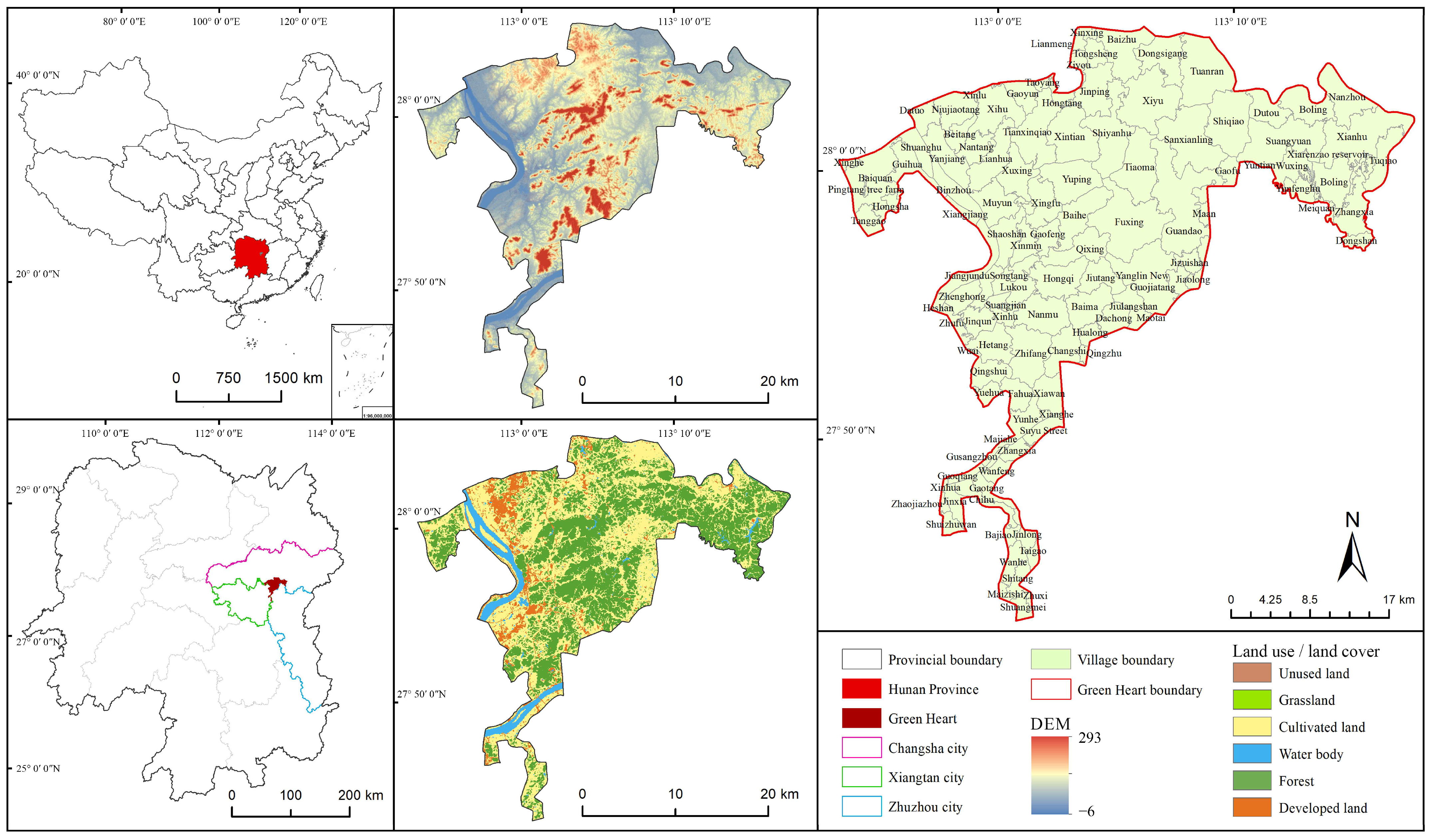
2.1. Case Study Area

Hunan Province is rich in water, energy, and food resources, which are mutually supportive. The province is home to Dongting Lake and water systems such as the Xiang, Zi, Yuan, and Li Rivers, providing abundant water resources. Hunan has the largest rice cultivation area in China and is a major grain-producing province, often referred to as the “land of fish and rice”. Although Hunan Province lacks coal and oil, it has actively developed renewable energy sources such as wind and solar power, continuously striving for a green and low-carbon transformation of its economy and society. Therefore, the coordinated development of water, energy, and food is of great importance for ensuring food, resource, and ecological security in the region and even across the country.
The Changsha–Zhuzhou–Xiangtan urban agglomeration (112°38′–114°17′ E, 27°37′–28°33′ N) is the core economic growth pole of Hunan Province and one of the most important and promising urban agglomerations in Central China [43]. The CZXGH region (112°53′–113°17′ E, 27°43′–28°05′ N) is located at the intersection of the three cities, with a total area of 528.32 km2, and is currently the largest Green Heart in the world [41], being 3.5 times larger than the Dutch Randstad urban agglomeration Green Heart [41,44]. The ecological condition of the CZXGH region is favorable, with diverse habitat types and a landscape characterized by a mix of hills and plains. The area is rich in forests, arable land, and water resources. However, as tourism and the nursery industry continue to develop within the CZXGH region, the resource supply–demand imbalance has intensified, and ecological issues have become increasingly prominent. This study defines the boundary of the CZXGH region, based on the “General Plan for the Ecological Green Heart Area of the Changsha–Zhuzhou–Xiangtan Urban Agglomeration (2010–2030, revised in 2018)”, covering 9 townships, 115 communities, and administrative villages (Figure 1).

2.2. Dataset

The fundamental data used in this study are shown in Table 1. These data are used for assessing ESs, constructing resistance surfaces, and Spearman coefficient analysis. All data will be projected, clipped, and also resampled to a uniform resolution of 30 m in ArcGIS 10.8. We choose all data in 2022, besides the DTB and DEM, which have the latest data from 2020 and 2011 separately. DTB was only changed in long timescales [45], and the DEM did not change as it was located in a stable geographical area.

3. Framework and Methodology

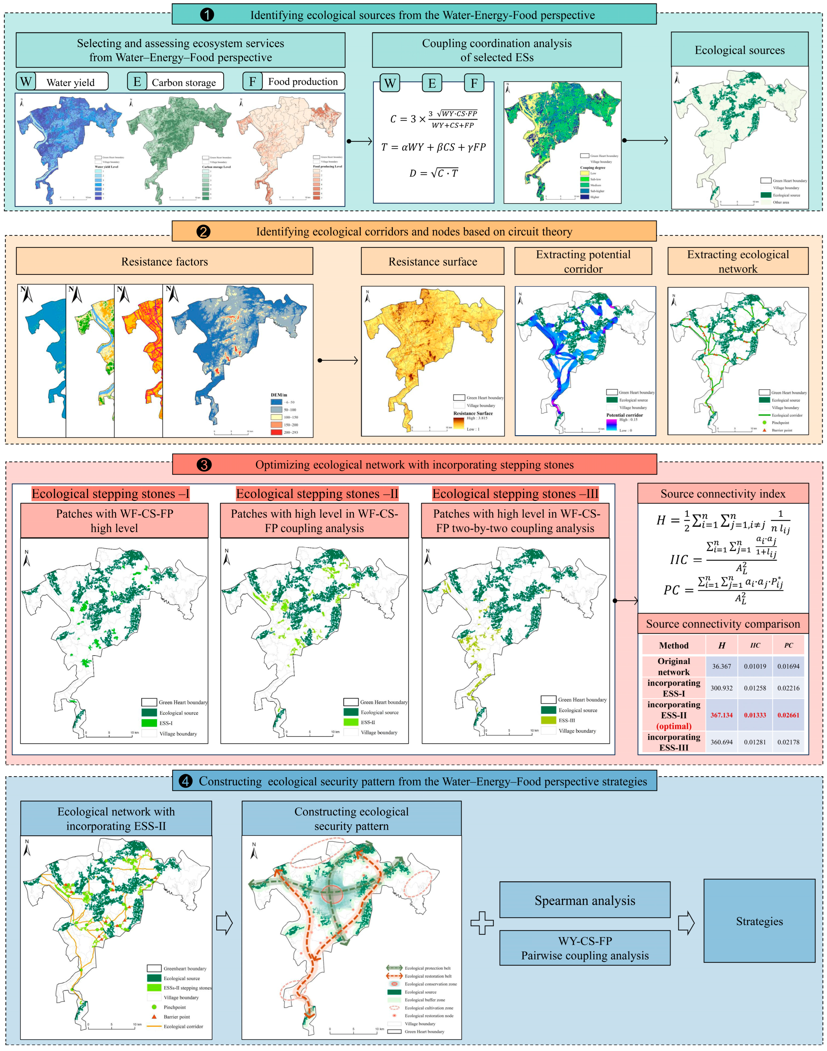
3.1. Methodological Framework

This paper presents a methodological framework for identifying ecological networks and optimizing ESPs by evaluating the ESs related to W-E-F. The framework consists of four steps (Figure 2). In the first phase, this study analyzes and selects Water yield (WY), Carbon storage (CS), and Food production (FP) as key ESs related to the W-E-F, their values quantified using the Integrated Valuation of Ecosystem Services and Trade-offs (InVEST) model and the Normalized Vegetation Index (NDVI). Then, it identifies ecological patches with high ES coupling coordination degrees (CCDs) as sources. In the second step, we construct the resistance surface by weighting and superimposing the four resistance factors. Next, we identify ecological corridors and nodes based on circuit theory and extract the ecological network. In the third step, we propose three ecological stepping stone (ESS) selection methods based on the assessment of ESs. And we compare the source connectivity quantitively by Conefor and then select the highest one as the optimal method. In the fourth step, we construct a final ESP with the optimal ESSs. Finally, we propose suggestions for the future development of the rural areas, considering the CCD of regional W-E-F, the influencing factors, and the structure of ESPs.

3.2. Identifying Ecological Sources

3.2.1. Selecting and Assessing ESs

In rural areas, the primary stakeholders related to W-E-F are villagers, factories, and government departments (agriculture, industry, and water resources) (Figure 3). For villagers, the ESs of WY and FP are directly related to agricultural production, economic income, and food security. CS is also closely linked to soil health and crop growth, directly affecting farmers’ well-being. For factories, WY is an indispensable resource for industrial production and processing, while CS helps reduce carbon emissions and improve energy efficiency. FP is critical for raw material supply and cost control. Government departments need to consider the coordinated development of all three sectors, formulating policies for water resource management, ecological protection, and agriculture to ensure human health and social stability. Previous studies have evaluated and demonstrated the deep connections between these ecosystem services and W-E-F [22,47,48,49]. Therefore, this study selects WY, CS, and FP as the basis for assessing W-E-F development and identifying ecological sources, aiming to promote the sustainable development of regional ecosystems.
The InVEST (Integrated Valuation of Ecosystem Services and Trade-offs) model [50,51] is commonly used for the quantitative assessment of ESs and can also reflect the distribution spatially [22]. For example, water supply refers to the ability of an ecosystem to intercept or store water resources from precipitation. The Water Yield model of the InVEST can quantify that [52]. Carbon storage refers to the ability of an ecosystem to store carbon dioxide from the atmosphere, which is calculated using the Carbon Storage and Sequestration model of InVEST [53].
Food production refers to the level of food, vegetables, and other crops provided by ecosystems. Government departments typically collect data at the city, district, and county levels. At the village level, this can be calculated through the significant linear relationship between food production and the NDVI of arable land [22,54].
The formulas and calculation processes for the three ESs are shown in the Supplementary Materials.

3.2.2. Identifying Ecological Sources Based on CCD of ESs

The coupling coordination degree (CCD) model refers to the phenomenon that two or more systems interact with each other through various interactions [23,55]. The W-E-F Nexus underscores the balance of subsystems, and the CCD model reveals that changes in subsystems will cause changes in whole system. Hoff observed that crossing critical thresholds at any scale could result in system changes [30]. We can calculate potential thresholds based on the CCD of a whole system, which offers guidance related to rural ecological security. A higher CCD indicates less discretization of subsystems, benefiting ecosystem security.
Based on a binary CCD, the following formulas are derived to calculate the W-E-F coupling degree (1), coordination degree (2), and coupling coordination degree (3). In accordance with previous research [22,30], although water plays a central role in the W-E-F nexus, WY, CS, and FP are considered of equal importance for whole-ecosystem security because subsystems are interchangeable. Thus, α = β = γ = 1/3.
Using ArcGIS 10.8, a fishing net grid was employed as the unit of analysis. This study used the Spatial Analyst tool to calculate the values of WY, CS, and FP for each evaluation unit, followed by the calculation of CCD. Functional distribution maps were then generated to reveal the spatial distribution within the study area. The composite layer was classified into five levels using the quantile method, ranging from higher to lower coupling degrees. Areas with above-average CCDs were identified as key habitats, and those larger than 2 km2 were selected as ecological sources (the area threshold selection process and all ecological sources are provided in the Supplementary Materials).
C = 3 × W Y · C S · F P 3 W Y + C S + F P
T = α · W Y + β · C S + γ · F P
D = C · T

3.3. Constructing Ecological Resistance Surface

Species and energy flows between different regions encounter barriers, which are modeled as resistance surfaces representing the difficulty of movement. Different land types and surface characteristics influence resistance. This study selected four barrier factors—DEM, slope, patch–corridor–matrix type, and road network density—and assigned resistance values to each factor across five levels, with higher levels indicating greater resistance (Table 2). The Spatial Principal Component Analysis (SPCA) method was used to determine weights and reduce information redundancy among these factors (the methodology of SPCA is provided in the Supplementary Materials). Finally, the raster calculator tool in ArcGIS was used to overlay resistance factors and generate a comprehensive resistance surface for the CZXGH region.

3.4. Extracting Ecological Corridors and Nodes

For corridor extraction, the Minimum Cumulative Resistance (MCR) model [56,57], Least-Cost Path (LCP) [58], and circuit theory [59] are the mainstream methods. Circuit theory simulates the random movement of biological flows in heterogeneous landscapes, enabling the construction of ecological corridors while scientifically identifying ecological nodes. This study employed circuit theory, integrating the distribution of ecological sources and the construction of resistance surfaces, to extract ecological corridors and nodes [60]. This approach effectively overcomes the limitation of the MCR model, which cannot identify ecological nodes and directly treats the geometric centroids of ecological sources as nodes [61]. Ecological nodes significantly influence landscape connectivity. Identifying these nodes helps determine the direction of ecological protection and restoration, thereby promoting the flow of materials and energy and enhancing ecological connectivity. Pinch points are critical nodes in the biological movement process, while barrier nodes are areas with high resistance during species movement and migration. The structure is shown in Figure 4.
First, this study used the Linkage Pathways tool in the Linkage Mapper toolbox on the ArcGIS platform to extract ecological corridors. Then, based on the results of the ecological corridor, the Pinchpoint Mapper tool, developed using circuit theory, was employed. A weighted cost distance of 500 was used as the potential corridor width, and iterative calculations were performed in the “all-to-one” mode to simulate areas of concentrated biological activity. The results were classified into five categories using the natural breaks method, with the highest category overlaid with corridor locations to determine the distribution of pinch points. The Barrier Mapper tool was then applied, using a search radius of 500 in the “Maximum” mode to simulate biological barrier zones. These results were overlaid with corridors to identify the spatial distribution of ecological barrier points.

3.5. Optimizing Ecological Network by Incorporating ESSs

3.5.1. Identifying ESSs

ESSs refer to channels, formed by a series of smaller patches, that facilitate the movement of organisms and energy between large ecological patches [62]. They are also a form of ecological nodes and can similarly be identified using circuit theory. The paradigm of constructing ESPs is shifting towards “sources–corridors–nodes”. Despite the significant role of nodes, they have not received sufficient attention in enhancing landscape connectivity. Most focus has been on large-scale protection and restoration, while the potential of small-scale protection and restoration has been overlooked. ESSs have the advantages of small size, discontinuity, and renewability, which align with the goals of developing human activities while preserving the ecosystem and promoting human welfare in rural areas [24]. Setting up ESSs between large patches can more flexibly enhance connectivity [60], reduce landscape fragmentation, and protect the integrity of the rural ecological environment.
This study, from the perspective of W-E-F, proposes three selection schemes for ESSs: (1) overlaying high-level patches of WY, CS, and FP; (2) extracting patches with high CCD of WY-CS-FP; (3) overlaying patches with high CCD between WY-CS, WY-FP, and CS-FP. These patches are then overlaid with potential ecological corridors, respectively, using an area larger than 0.1 km2 and less than 2 km2 as a common condition, to select ESSs for further use (a detailed methodology is provided in the Supplementary Materials). According to the average performance level, the top 30 patches from each scheme were selected as the final ESSs, which are referred to as ESSs-I, ESSs-II, and ESSs-III in this study. These ESSs serve as new ecological sources, from which ecological corridors can be extracted in the same way.

3.5.2. Evaluating Source Connectivity Before and After Optimization

Source connectivity refers to the degree of connectivity between ecological sources, representing how the landscape pattern either facilitates or hinders the diffusion of ecological flows [63]. The quantification of source connectivity is based on the spatial distribution of ecological patches, combined with species dispersal abilities, to calculate habitat accessibility [64]. Currently, graph theory-based analysis methods, grounded in spatial pattern theory, are widely used in the quantification of landscape connectivity [65,66,67]. Based on this, the landscape performance before and after incorporating ESSs was analyzed by relevant indices of connectivity in graph theory, including the binary connectivity index H (Harary index), IIC (Integral Index of Connectivity), and PC (Possible Connectivity) [65,68,69] (Table 3). The connectivity indices were calculated by Conefor Sensinode 2.6.

3.6. Constructing Rural ESP with Optimized Network

In 1995, Forman, the father of modern landscape ecology, proposed the concept of the landscape ecological pattern based on the patch–corridor–matrix model [70]. In 1996, Yu first proposed an ESP as a potential spatial pattern, the functional components of which largely correspond to the physical components in the representation model of landscape ecology such as patches, corridors, and networks [6]. Thus, the rural ESP was constructed based on an optimized network, ensuring the function was correct.

4. Results

4.1. Ecological Sources

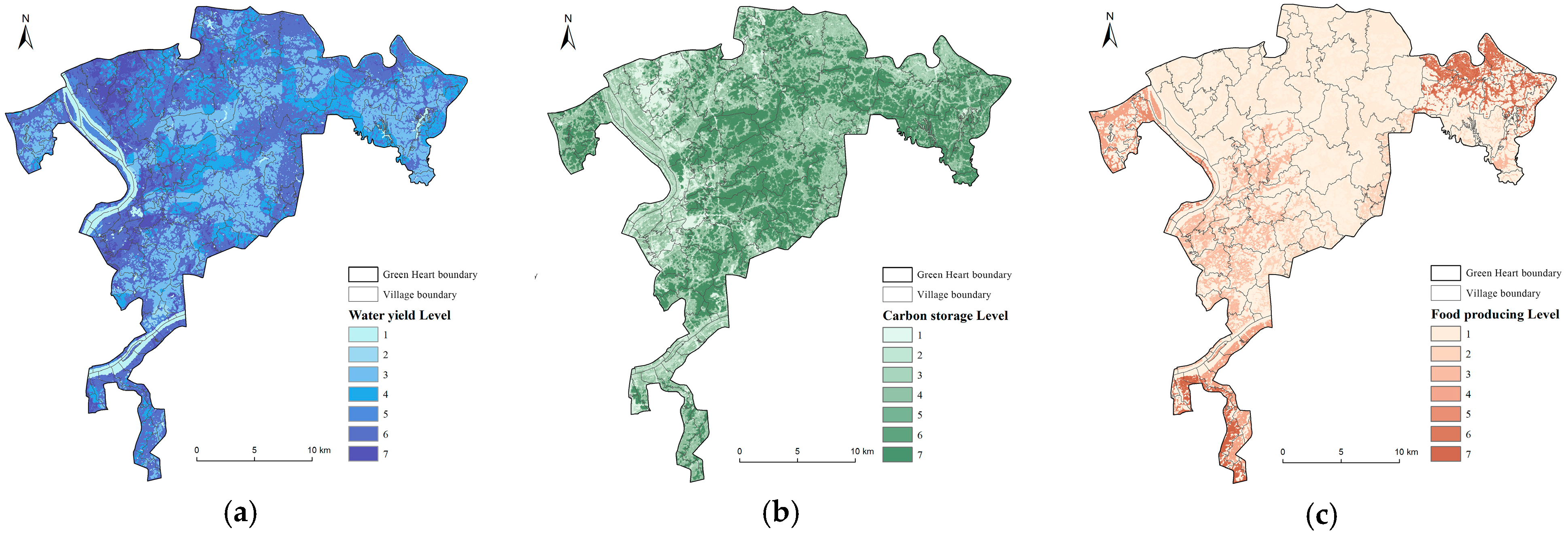
4.1.1. Assessment of Selected ESs

WY, CS, and FP exhibit significant spatial heterogeneity, as shown in Figure 5. Patches above the average level are considered high-value areas, classified as level 5 or higher.
High-value areas for WY are primarily distributed in the northern, central-eastern, and southern parts of CZXGH. Combined with Figure 1, villages such as Xihu, Beitang, Muyun, Guandao, and Tiaoma exhibit higher WY. Corresponding patch–corridor–matrix types include developed land and cultivated land. WY is mainly influenced by precipitation and evaporation, with impervious surfaces and farmland reducing water evaporation and infiltration.
High-value areas for CS are mainly concentrated in the central and eastern forested regions of CZXGH, with high vegetation coverage. Villages such as Qixing, Fuxing, Yanglin, Shiqiao, Yuping, and Shuangyuan are prominent examples. These areas have recently implemented initiatives such as afforestation and degraded forest restoration to enhance Carbon Storage capacity. For instance, Fuxing Village adopted methods like selective thinning (removing smaller or denser trees) and supplementing with rare and high-quality species to restore degraded forests [71].
High-value areas for FP are concentrated in Bailin, Shuangyuan, Xianhu, Wanhe, and Chihu villages, primarily in the northeastern and southwestern parts of the CZXGH. However, agricultural areas in central villages like Guandao and Sanxianling show low FP. Field investigations revealed that these villages, part of Tiaoma Town—famous for horticulture—utilize most farmland for nursery plant cultivation rather than food production, making food production less dominant.

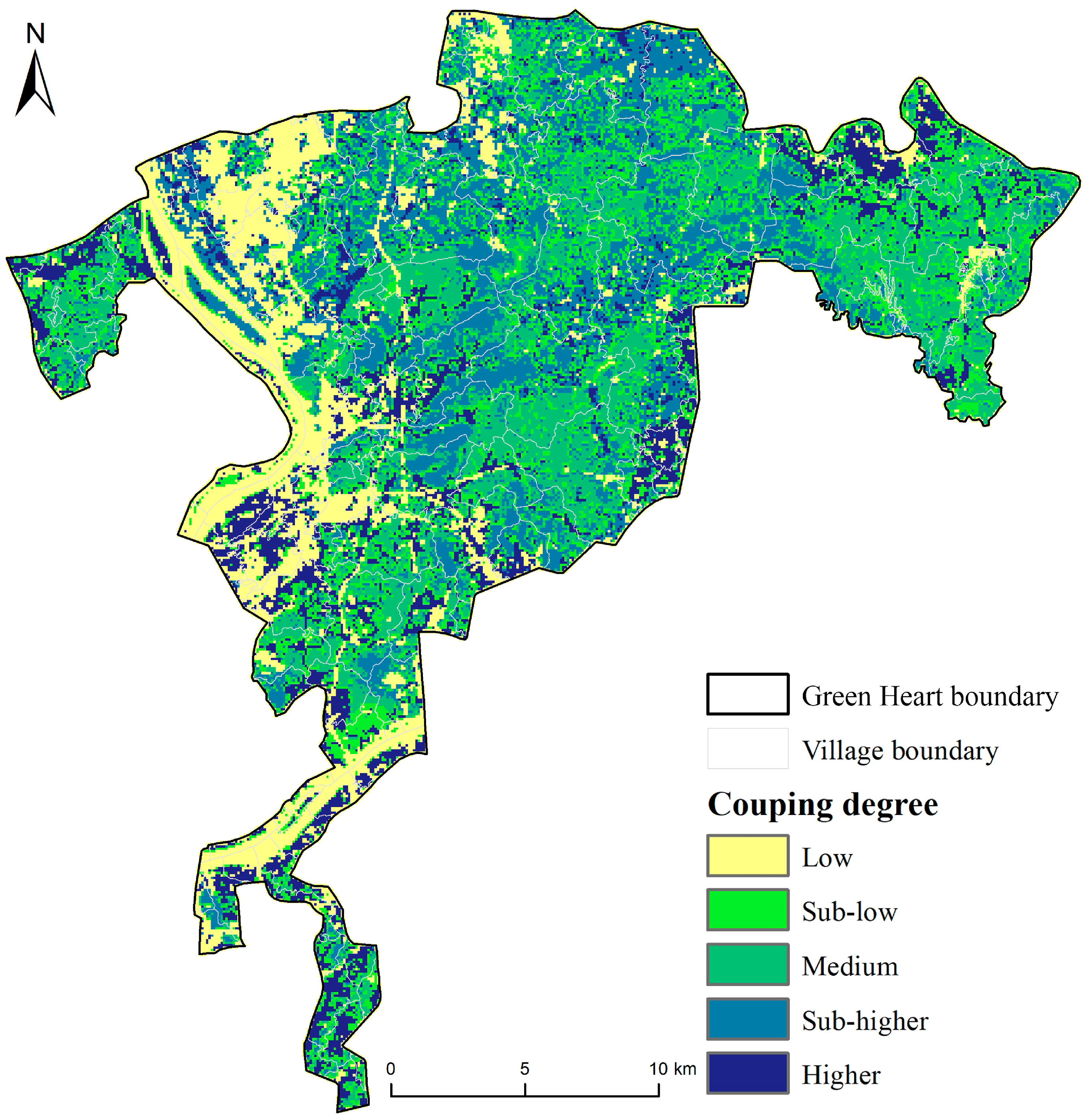
4.1.2. WF-CS-FP Coupling Coordination Analysis

Five distinct patches with varying levels of CCD were identified, ranging from low to high (Figure 6), with areas of 74.55, 124.32, 122.04, 110.82, and 96.59 km2. Areas with high CCD are primarily located in the central and northern parts of CZXGH, dominated by farmland and forestland, while low-CCD areas are mostly in the western region, characterized by water bodies and built-up land.

4.1.3. Identification of Ecological Sources

A total of 14 ecological sources were identified, mainly distributed in the northeastern, central, and southwestern parts of CZXGH, covering a total area of 86.73 km2 (Figure 7). The predominant land-use type is forestland (approximately 25.59 km2), followed by farmland (approximately 60.61 km2), together accounting for 99.39% of the total area. Spatially, the sources are more abundant in the central and northern parts but are dispersed.

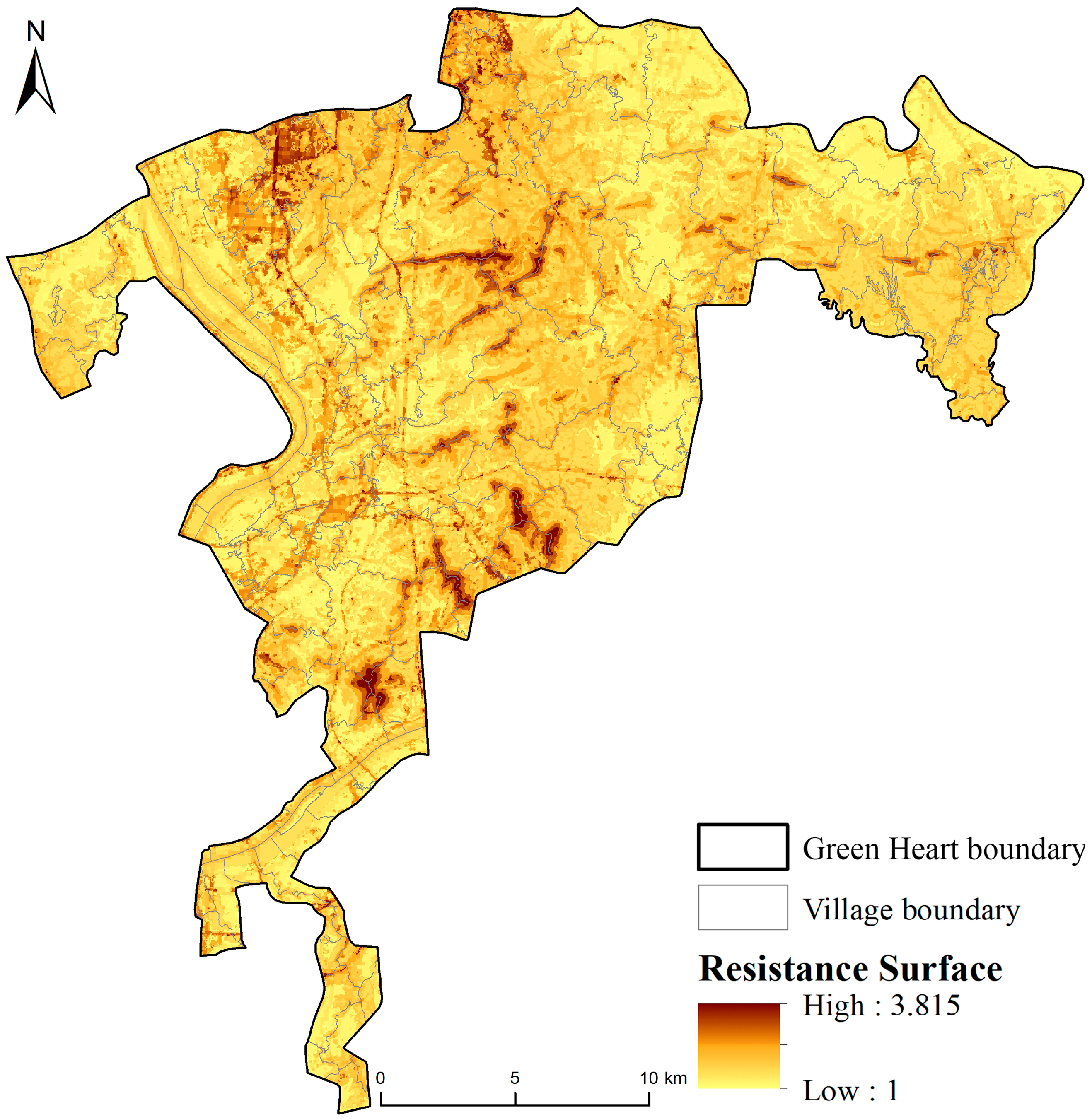
4.2. Resistance Surface

The comprehensive resistance surface is shown in Figure 8. High-resistance areas are primarily concentrated in construction lands with intensive human activities and limited green space. The central hilly region, with well-connected forestlands, forms a low-resistance area where species migration and diffusion are more facilitated. In contrast, areas with high road density and elevated terrain create barriers to energy and species flow, fragmenting the connectivity between green spaces, thus forming high-resistance zones.

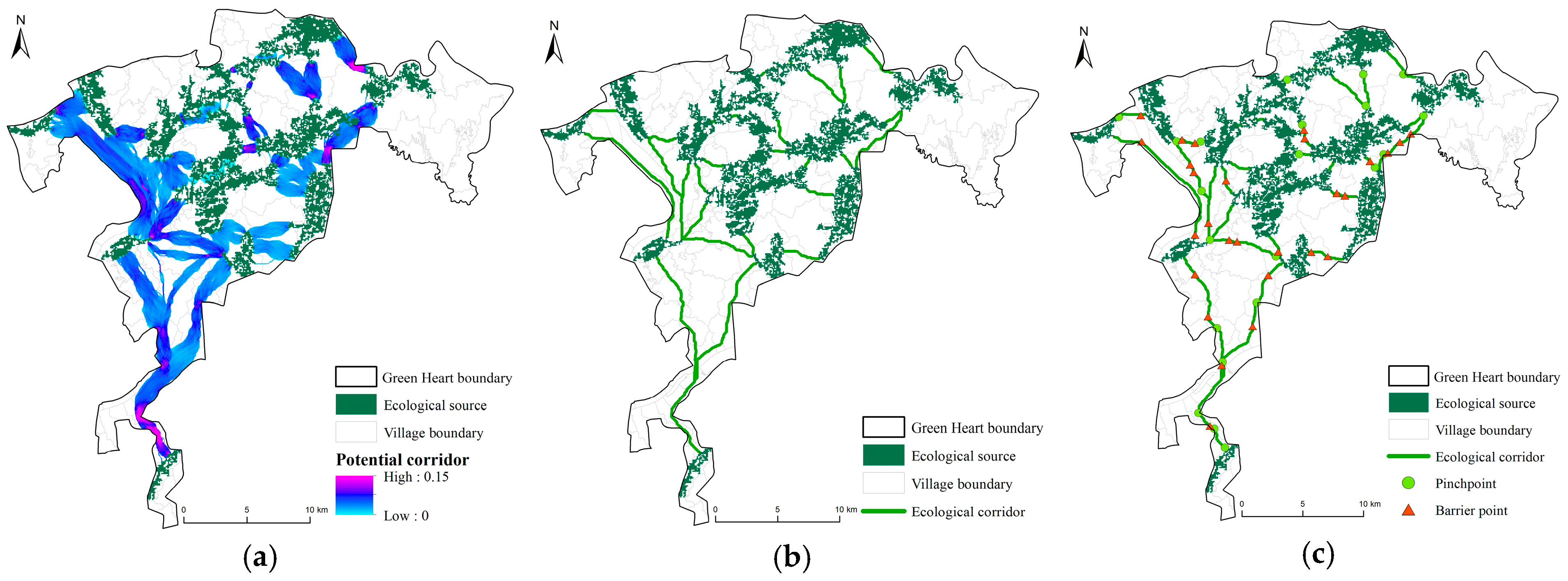
4.3. Ecological Corridor, Pinch, and Barrier Points

The potential ecological corridors within the CZXGH region, calculated with a weighted average distance of 500 m, are shown in Figure 9a. Overall, the western valleys serve as the primary aggregation zones for ecological corridors, mainly located in farmland between forestlands. In the eastern and southern regions, ecological corridors are distributed among fragmented habitat patches segmented by construction lands, most of which are forestlands. The study identified 28 ecological corridors within CZXGH, as illustrated in Figure 9b, including 3 inactive corridors. The total corridor length is 117.21 km, with the longest measuring 19.59 km. These corridors effectively connect ecological sources in the north–south and east–west directions, providing a foundation for species and energy migration and flow.
The distribution of ecological pinch points and barrier points is shown in Figure 9c. Both are relatively scattered, with pinch points primarily associated with forestland and farmland and barrier points mainly related to construction lands and farmlands. Notably, restoring barrier points is crucial for ecological connectivity, particularly those near pinch points, which should be prioritized to ensure smooth energy flow at pinch locations.

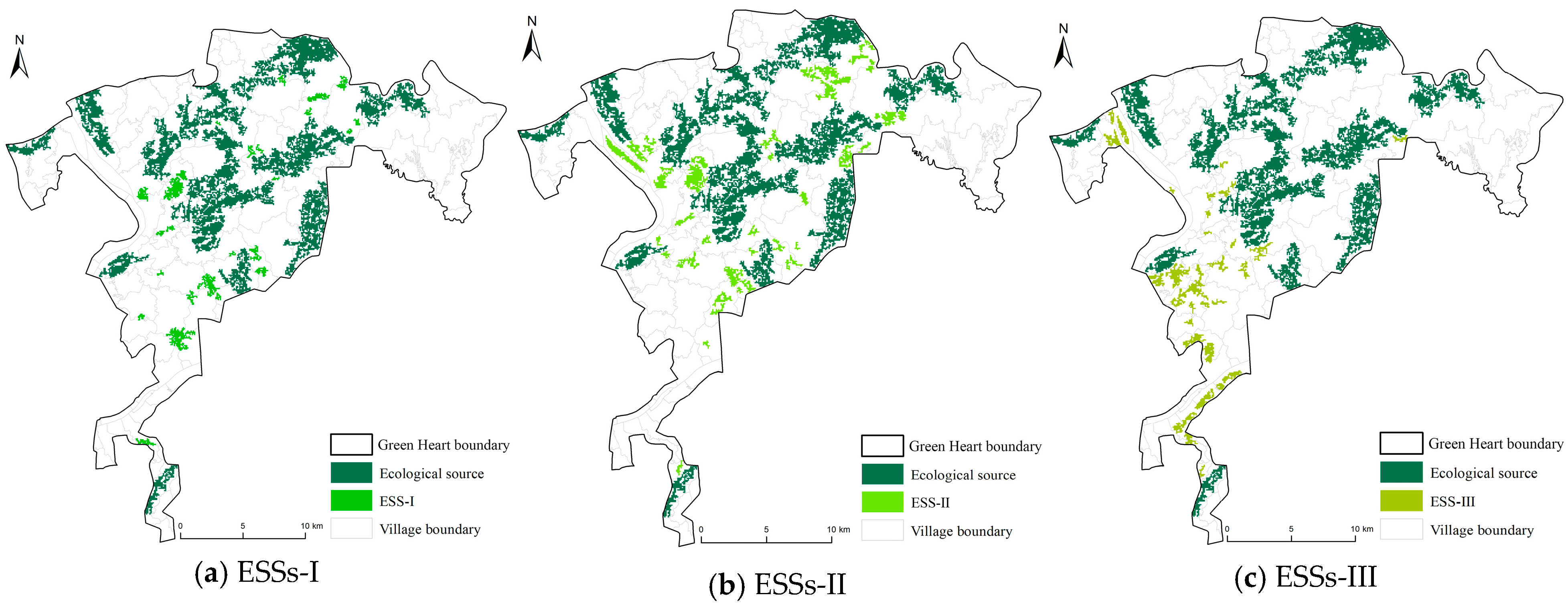
4.4. Ecological Stepping Stones

The identification of the three ESSs reveals distinct spatial distributions in Figure 10. ESSs-I are relatively scattered, ESSs-II are mainly concentrated in the central and northern parts of the area, and ESSs-III are predominantly in the western region. Their spatial distribution exhibits heterogeneity, with forestland and farmland being the primary land-use types. These three ESS schemes provide potential solutions for the coordinated development of water, energy, and food resources in the future. The average areas of the stepping stones are 0.390, 0.456, and 0.463 km2, accounting for 2.19%, 2.56%, and 2.60% of the total area of CZXGH.

4.5. Ecological Network Optimization Based on Incorporating ESSs

After adding the three ESSs, the number of ecological corridors increased by 72, 68, and 67, with total lengths of 164.19 km, 153.57 km, and 132.79 km. ESSs-I contributed the most, adding 46.98 km to the original corridor. Ecological barriers were significantly reduced; ESSs-I and ESSs-II both eliminated 17 barriers, while ESSs-III removed 14. Additionally, ecological nodes in ESSs-II and ESSs-III showed notable improvement, with both adding 10 new nodes. These results indicate that the incorporation of ESSs effectively eliminates barriers within the ecological network and enhances connectivity between patches.
The results of source connectivity calculations before and after optimization are shown in Table 4. A comparison of the three schemes reveals that adding ESSs significantly enhances the Harary index (H) and Possible Connectivity (PC) while having a relatively weaker impact on the Integral Index of Connectivity (IIC). ESSs-II achieved the greatest improvement in Source Connectivity, increasing H, IIC, and PC by 909.53%, 30.86%, and 57.10%. These findings indicate that the ESSs selected based on a high CCD of WY-CS-FP are the most effective for improving source connectivity. In comparison to the other two schemes, it accentuates the integrated development within W-E-F, which is more conducive to consolidating the ecological network with enhanced overall performance.

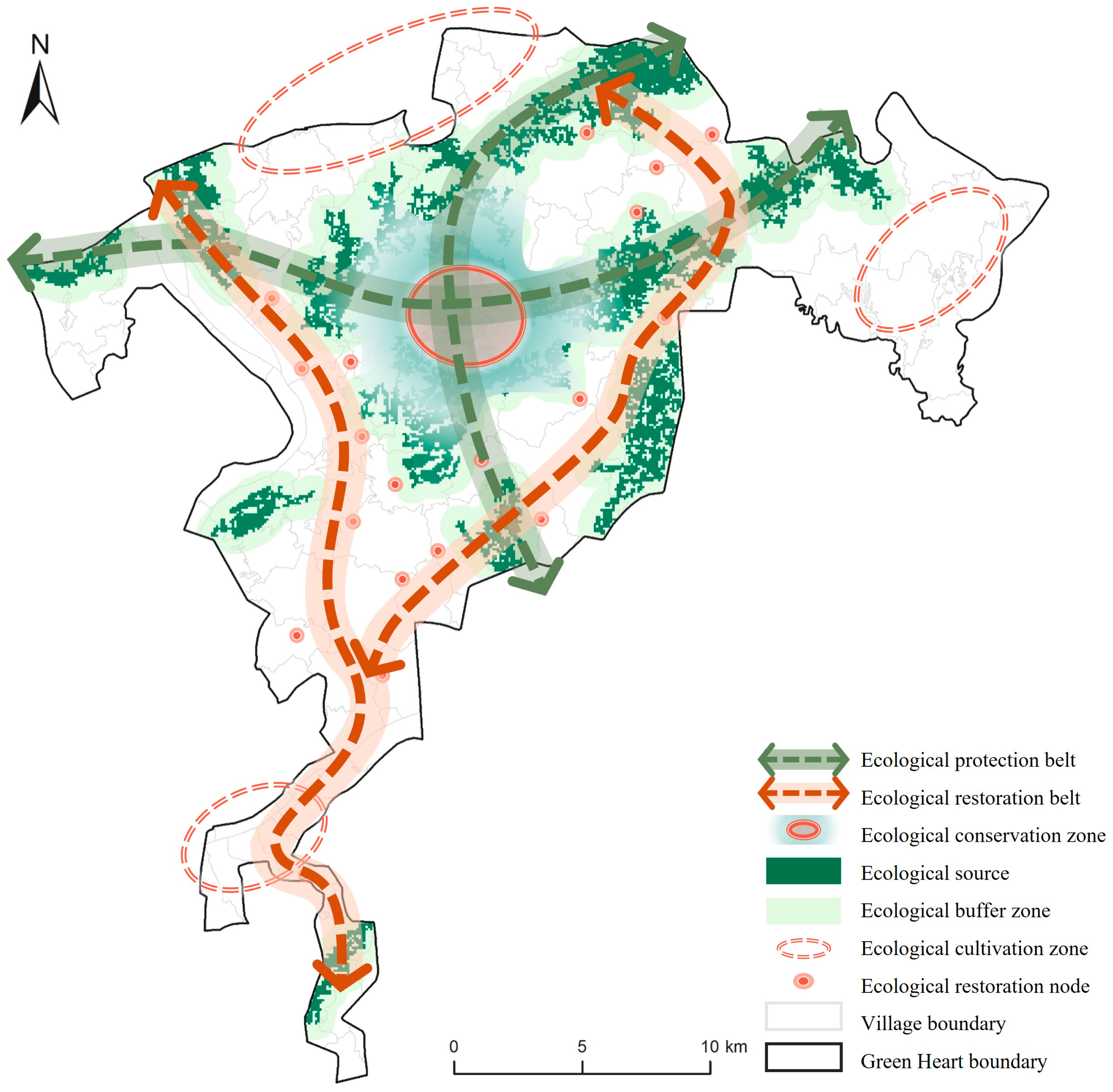
4.6. Ecological Security Pattern

Based on ecological network optimization with incorporating the optimal ESSs, combined with the CCD of WY-CS-FP, a “One Core, Three Zones, Four Belts, and Multiple Nodes” strategy was developed, as illustrated in Figure 11.
(1)
One Core
The ecological sources within the study area are relatively concentrated, primarily located in the central and northern regions, with most sources belonging to Changsha City. The ecological patches within the core area are closely connected, serving as the central hub for ecological material flows in terms of both geographic location and ecological configuration.
(2)
Three Zones
These consist of ecological conservation zones, ecological buffer zones, and ecological cultivation zones. Areas containing ecological sources are designated as ecological conservation zones, which exhibit the best ecological performance and require prioritized protection. A width of 600 m achieves a radiation area coverage of 51.67% exceeding 50% (calculations in Table S3); thus, a 600 m radius around the sources was chosen as the ecological buffer zone [2]. Ecological cultivation zones cover areas not included within the ecological sources and exhibit poorer ecological performance, mainly distributed in the northeastern, northwestern, and southern parts of the area.
(3)
Four Belts
Based on the distribution of ecological sources and corridors within the area, ecological protection belts and restoration belts were delineated. The ecological protection belts primarily connect key ecological sources along the east–west and north–south axes of the site, serving as the main channels for species migration and energy flow. Ecological restoration belts were identified according to the layout of corridors in the optimized ecological network, primarily connecting distant sources in the north–south direction within the eastern and western regions, to enhance ecological connectivity and restoration.
(4)
Multiple Nodes
The locations of optimal ESSs were designated as multiple ecological restoration nodes. The protection and restoration of these small-scale nodes are critical for effectively enhancing rural ecological connectivity.

5. Discussion

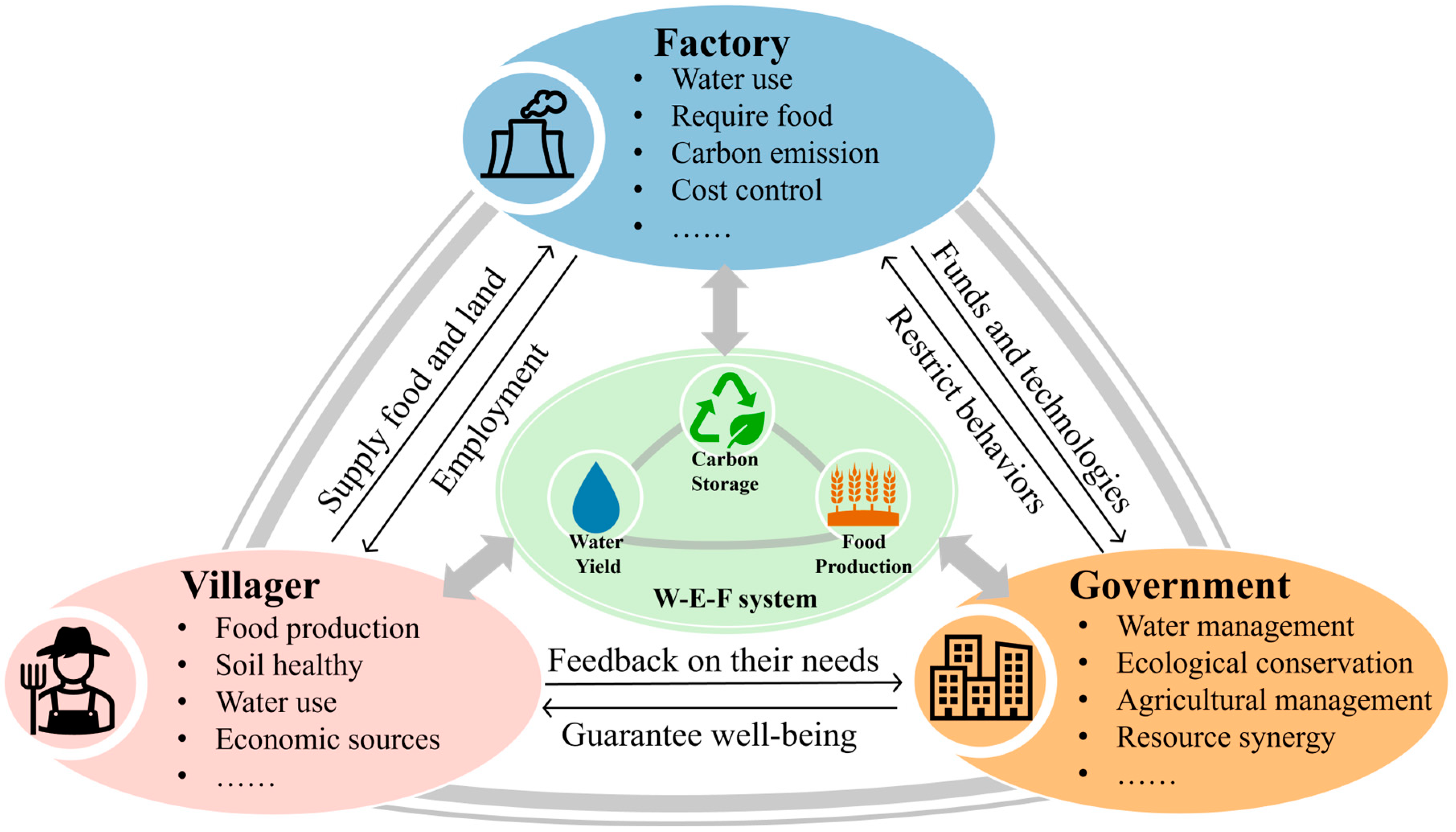
5.1. Rural Ecological Conservation Practices and Implications from a W-E-F Coupled Coordination Perspective

In rural areas, especially in peri-urban regions with favorable ecological conditions, multiple challenges arise from limited resources, inadequate infrastructure, environmental changes, and land-use conflicts. Water, energy, and food are the most critical resources within rural ecosystems. The W-E-F Nexus emphasizes a systematic management approach based on these three interconnected resources. Coupled and coordinated development further highlights the interactions and interdependencies among different subsystems, expanding integrated analysis and solution frameworks from the W-E-F Nexus perspective. This approach effectively optimizes resource utilization, enhances system resilience, and promotes greater systematization, sustainability, and holistic benefits in rural ecosystems.
The study shows that there are differences in coupling coordination across regions. Rural areas with better performance in the study area are mostly located in Zhuzhou City, Xiangtan City, and the Pingtang, Nantuo, and Baijia towns of Changsha City. The region with the highest CCD is Nanzhou Village in Zhuzhou City, achieving a score of 0.81. These areas are rich in cultivated land and water resources, focusing on ecological and multifunctional agriculture as well as improving the quality of agricultural products. Additionally, these areas are often accompanied by residential settlements, indicating that areas can enhance experiences of residents while protecting resources. The integration of primary, secondary, and tertiary industries has promoted mutual transformation and coupled development of diverse ecological resources. Poorly performing areas tend to exhibit more singular ecological resources or structures and insufficient investment in ecological environmental management. To ensure the coordinated and sustainable development of rural resources, agricultural or forestry planting structures should be actively adjusted, optimizing the configuration of land and water resources. The interconnections and transformation of various ecological resources should be strengthened. This includes promoting green and organic agriculture, optimizing planting systems and crop rotation, expanding professional training for agricultural workers, and advancing energy-efficient and modern agriculture. These actions align with the vision for the rural future presented in Liu’s study [72].
To scientifically promote the coordinated development of the W-E-F in rural areas, the study identified 14 significantly related driving factors, including annual maximum temperature, soil moisture, average annual wind speed, rainfall erosivity, road density, slope, water proportion, cultivated land proportion, etc. The process and results of Spearman correlation analysis are shown in Section S7 of the Supplementary Materials. The correlations between these factors and the CCDs of WY-CS-FP, WY-CS, WY-FP, and CS-FP are shown in Figure 12. Results indicate that many factors exhibit positive correlations with the CCDs of WY-CS-FP, except for road density and nighttime light index, which show negative correlations. This suggests that socio-economic drivers may negatively impact W-E-F CCD, while climate drivers (HT, SW, TP, RE, AWS) and land-use drivers (CLP, ALP, WLP, WP) have positive effects. Overall, the influence of climate factors is relatively weak. In the future, apart from controlling socio-economic factors, the focus of ecological protection and restoration should shift to land use. Comparing the correlations of ALP and WLP with various environmental factors, it was found that they often show significant opposing trends, indicating that the main conflict in W-E-F coupling development still lies between cultivated land and wood land. Although ecological sources are mostly cultivated land or woodland, this does not imply consistent demands and development for both. Rural areas should consider conditions such as NDVI, slope, and elevation to explore methods for alleviating the conflict between cultivated land and woodland, thereby enhancing W-E-F CCD and ensuring food security [73]. This could include zonal planting, optimizing the planting structure at the boundaries between cultivated land and woodland to increase carbon sequestration, and developing agroforestry or under-forest crops to relieve pressure on cultivated land.

5.2. The Selection and Advantages of Stepping Stones in Rural ESP Construction

The construction of ESPs has been grounded in the foundational paradigm of “patch–corridor–matrix”. However, given the characteristics of limited space, fragmentation, and significant land-use conflicts in rural areas, this study emphasizes a paradigm shift towards “patch–stepping stone–matrix” [26]. This paradigm highlights the advantages of ESSs in rural ESP construction. Due to their smaller scale and higher feasibility of implementation, ESSs serve as an effective method for small-scale ecological protection and restoration, better aligning with the needs of optimizing rural ESPs. Previous studies have also discussed the importance of ESSs in reducing land-use conflicts and investment costs in ESP construction [26,74], particularly their significant positive impact on enhancing landscape connectivity [24], which is consistent with our findings. Our study revealed that the three ESS selection schemes could increase corridors’ total lengths by 40.08%, 31.02%, and 13.29% and improve the source connectivity by 30.83%, 57.10%, and 28.57%. This confirms the critical role of ESSs in constructing a rural ESP.
This study has extended ESS selection from a “single ES” perspective to “coupled ESs”. The integrated development perspective not only aligns better with the multifunctional characteristics of rural areas but also directly addresses the ecological value of cultivated land, contributing to alleviating rural land-use conflicts. Furthermore, coordinated development deserves priority protection over single demands, as it is more capable of promoting ecological network connectivity and achieving maximum benefits at lower costs.
Quantitatively comparing the effects of the three schemes reveals that ESSs selected based on a high CCD of WY-CS-FP are more effective for ESP optimization. This approach focuses more on the coordination level and overall benefits of W-E-F development, facilitating system-wide optimization. These findings further confirm the significance and necessity of ecological source protection and ESP construction from the perspective of W-E-F coupling coordination development. On the other hand, there are some conflicts in land tenure and characteristics in ESS construction. Under Chinese policy, considering the red line of permanent arable land and ecological protection to ESS construction can avoid conflicts. For ecological optimization of normal cultivated land, an applied compensation mechanism to farmers can achieve an all-win with governments and factories.

5.3. Management Practices and Directions in Rural ESP

This study proposes an ESP for CZXGH, characterized by a framework of “One Core, Three Zones, Four Belts, and Multiple Nodes”. Thus, we proposed tailored and differentiated policy recommendations. For ecological sources with high-CCD ESs, human-induced ecological damage should be minimized. Practical measures include establishing rural forest parks, designating farmland protection zones, enhancing water source management, and reducing human disturbances. For ecological cultivation zones, we proposed measures including promoting public-benefit forestry, regulating water use for irrigation and agriculture, and conserving water resources, which can benefit residents and release the pressure of related government. Utilizing untapped renewable energy sources, such as wind and solar energy, can alleviate energy supply pressures and enhance energy provision, while bringing more benefits to factories and governments.
The W-E-F Nexus is central to sustainable development [75]. Ecological corridors can facilitate energy exchange and resource transformation among water, energy, and food, thereby enhancing the provision and transmission of ESs. For example, improving groundwater circulation, storage, and recycling capacity can ensure sustainable resource development. Future efforts should prioritize ecological nodes along ecological restoration corridors. Optimization measures should be guided by the CCD of W-E-F and pairwise W-E-F (Figure 11 and Figure 13). For instance, the western ecological restoration belt, adjacent to the river, has a low CCD of W-E-F while having a better W-F. Therefore, the stakeholders like governments and factories should focus more on enhancing the protection of existing water resources, developing new clean energy, and establishing connections and transformations between water and energy. In contrast, the eastern ecological restoration belt has a weaker W-F CCD. Stakeholders can make efforts together to adjust the planting structure, optimize the allocation of crops and water resources, and improve agricultural water use efficiency.

5.4. Limitations and Further Prospects

This study has several limitations that warrant further exploration in future research. Firstly, due to the limited availability of rural-scale statistical data, this research did not conduct an analysis of the relationships between more ESs and the W-E-F systems. Instead, it focused on three typical ESs with strong validated correlations. Future studies should identify ESs that better reflect the interconnections within the W-E-F Nexus and explore the influence mechanisms between them [22]. In constructing and optimizing the ESP, this study primarily considered improvements in connectivity. Indicators such as network stability, effectiveness, resilience, and climate adaptability should also be evaluated to assess the overall quality of ecological networks. For ESS selection, future studies could examine alternative selection strategies based on factors such as corridor length or ecological pinch-point distances [24], comparing their results with those of the current study to identify optimal solutions. Shape requirements also can be applied to ESS selection, through the assessment of patch density, largest patch index, and splitting index by Fragstats. Moreover, scale plays a crucial role in developing comprehensive ESPs. Different ecological research methods across varying scales yield distinct patterns and processes [43,55]. Future studies should explore ESP construction methods and priorities across different scales to enhance multi-scale nesting and coordination development. Finally, future studies can apply the framework to other rural areas like arid or high-density countryside, which have different environmental characteristics and conditions of W-E-F. A more comprehensive framework of rural ESP construction will be conducted through critical comparisons.

6. Conclusions

This study proposes a methodological framework for constructing and optimizing rural ESPs by assessing the CCD of ESs selected from a W-E-F perspective. It emphasizes balancing W-E-F coordinated development with small-scale ESS adjustments for ecological network optimization. The CZXGH region serves as a typical case study.
Results reveal that the areas with high CCDs of WY-CS-FP are rich in cultivated land and water resources, focusing more on ecological and multifunctional agriculture, enhancing experiences of residents while protecting resources. Socio-economic drivers negatively impact W-E-F CCD, while climate and land-use drivers have positive effects. For ESS selection, the approach based on a high CCD of W-E-F effectively enhances source connectivity, which increases total ecological corridor length to 153.57 km and raises the PC index by 57.1%, quantitatively validating the effectiveness of small-scale ecological restoration in enhancing the overall ecological network. We proposed the ESP of “One Core, Three Zones, Four Corridors, and Multiple Nodes”, emphasizing the importance of ecological nodes, which are more suitable for small-scale rural areas’ protection and can achieve high efficiency with low costs.

Supplementary Materials

The following supporting information can be downloaded at: https://www.mdpi.com/article/10.3390/land14040862/s1, Table S1. Critical parameter settings in the biophysical attributes table. Table S2. Principal component load matrix, cumulative contribution rate, and weight of CZXGH. Table S3. The proportion of radiation area for different buffer widths. Table S4. Correlation analysis of potential environmental driving factors. Figure S1. Alternative source of CZXGH. Figure S2. Alternative source patch area normal distribution curve. Figure S3. Value and distribution of WY-CS-FP overlaying and pairwise coupling. Figure S4. Area distribution of pre-selected stepping stone patches. Figure S5. Resistance surface of each resistance factor: (a) digital evaluation model (DEM); (b) slope; (c) land use/land cover; (d) road density. Figure S6. The change curves of IIC and PC. References [76,77,78,79,80,81] are cited in the Supplementary Materials.

Author Contributions

Conceptualization, J.T. and A.Z.; Methodology, J.T., B.Z., J.L. and L.Z.; Software, B.Z.; Writing—original draft, J.T. and B.Z.; Writing—review & editing, J.L., A.Z. and L.Z.; Visualization, J.T. and B.Z.; Supervision, J.L.; Project administration, L.Z.; Funding acquisition, A.Z. and L.Z. All authors have read and agreed to the published version of the manuscript.

Funding

This research was funded by National Natural Science Foundation of China, grant numbers 5207083234 and 52408036.

Data Availability Statement

The original contributions presented in this study are included in the article/Supplementary Material. Further inquiries can be directed to the corresponding author.

Conflicts of Interest

The authors declare no conflict of interest.

References

  1. Costanza, R.; D’Arge, R.; De Groot, R.; Farber, S.; Grasso, M.; Hannon, B.; Limburg, K.; Naeem, S.; O’Neill, R.V.; Paruelo, J.; et al. The value of the world’s ecosystem services and natural capital. Nature 1997, 387, 253–260. [Google Scholar] [CrossRef]
  2. Ding, T.; Chen, J. Evaluating supply-demand matching of ecosystem services considering water-energy-food nexus and synergies/trade-offs in the Hangzhou of China. Environ. Sci. Pollut. Res. 2023, 30, 54568–54585. [Google Scholar] [CrossRef] [PubMed]
  3. Jia, Q.; Jiao, L.; Lian, X.; Wang, W. Linking supply-demand balance of ecosystem services to identify ecological security patterns in urban agglomerations. Sustain. Cities Soc. 2023, 92. [Google Scholar] [CrossRef]
  4. Zhao, Y.; He, L.; Bai, W.; He, Z.; Luo, F.; Wang, Z. Prediction of ecological security patterns based on urban expansion: A case study of Chengdu. Ecol. Indic. 2024, 158, 111467. [Google Scholar] [CrossRef]
  5. Wen, J.; Hou, K. Research on the progress of regional ecological security evaluation and optimization of its common limitations. Ecol. Indic. 2021, 127. [Google Scholar] [CrossRef]
  6. Yu, K. Security patterns and surface model in landscape ecological planning. Landsc. Urban Plan. 1996, 36, 1–17. [Google Scholar] [CrossRef]
  7. Ogden, J.C.; Baldwin, J.D.; Bass, O.L.; Browder, J.A.; Cook, M.I.; Frederick, P.C.; Frezza, P.E.; Galvez, R.A.; Hodgson, A.B.; Meyer, K.D.; et al. Waterbirds as indicators of ecosystem health in the coastal marine habitats of Southern Florida: 2. Conceptual ecological models. Ecol. Indic. 2014, 44, 128–147. [Google Scholar] [CrossRef]
  8. Kubacka, M.; Żywica, P.; Vila Subirós, J.; Bródka, S.; Macias, A. How do the surrounding areas of national parks work in the context of landscape fragmentation? A case study of 159 protected areas selected in 11 EU countries. Land Use Policy 2022, 113, 105910. [Google Scholar] [CrossRef]
  9. Jiang, H.; Peng, J.; Xu, D.; Tang, H. Constructing ecological security patterns with differentiated management intensity based on multifunctional landscape identification and multi-criteria decision-making. Glob. Ecol. Conserv. 2024, 50, e02862. [Google Scholar] [CrossRef]
  10. Hu, Y.; Gong, J.; Li, X.; Song, L.; Zhang, Z.; Zhang, S.; Zhang, W.; Dong, J.; Dong, X. Ecological security assessment and ecological management zoning based on ecosystem services in the West Liao River Basin. Ecol. Eng. 2023, 192, 106973. [Google Scholar] [CrossRef]
  11. Peng, J.; Zhao, H.; Liu, Y.; Wu, J. Research progress and prospect on regional ecological security pattern construction. Geogr. Res. 2017, 36, 407–419. [Google Scholar]
  12. Ding, M.; Liu, W.; Xiao, L.; Zhong, F.; Lu, N.; Zhang, J.; Zhang, Z.; Xu, X.; Wang, K. Construction and optimization strategy of ecological security pattern in a rapidly urbanizing region: A case study in central-south China. Ecol. Indic. 2022, 136, 108604. [Google Scholar] [CrossRef]
  13. Xiang, H.; Zhang, J.; Mao, D.; Wang, M.; Yu, F.; Wang, Z.; Li, H. Optimizing ecological security patterns considering zonal vegetation distribution for regional sustainability. Ecol. Eng. 2023, 194, 107055. [Google Scholar] [CrossRef]
  14. Wang, N.; Zhao, Y. Construction of an ecological security pattern in Jiangnan water network area based on an integrated Approach: A case study of Gaochun, Nanjing. Ecol. Indic. 2024, 158, 111314. [Google Scholar] [CrossRef]
  15. Peng, J.; Pan, Y.; Liu, Y.; Zhao, H.; Wang, Y. Linking ecological degradation risk to identify ecological security patterns in a rapidly urbanizing landscape. Habitat Int. 2018, 71, 110–124. [Google Scholar] [CrossRef]
  16. Huang, X.; Wang, H.; Shan, L.; Xiao, F. Constructing and optimizing urban ecological network in the context of rapid urbanization for improving landscape connectivity. Ecol. Indic. 2021, 132, 108319. [Google Scholar] [CrossRef]
  17. Liu, H.; Wang, Z.; Zhang, L.; Tang, F.; Wang, G.; Li, M. Construction of an ecological security network in the Fenhe River Basin and its temporal and spatial evolution characteristics. J. Clean. Prod. 2023, 417, 137961. [Google Scholar] [CrossRef]
  18. Wei, B.; Kasimu, A.; Fang, C.; Reheman, R.; Zhang, X.; Han, F.; Zhao, Y.; Aizizi, Y. Establishing and optimizing the ecological security pattern of the urban agglomeration in arid regions of China. J. Clean. Prod. 2023, 427, 139301. [Google Scholar] [CrossRef]
  19. Mu, H.; Li, X.; Ma, H.; Du, X.; Huang, J.; Su, W.; Yu, Z.; Xu, C.; Liu, H.; Yin, D.; et al. Evaluation of the policy-driven ecological network in the Three-North Shelterbelt region of China. Landsc. Urban Plan. 2022, 218, 104305. [Google Scholar] [CrossRef]
  20. Fagerholm, N.; Torralba, M.; Moreno, G.; Girardello, M.; Herzog, F.; Aviron, S.; Burgess, P.; Crous-Duran, J.; Ferreiro-Domínguez, N.; Graves, A.; et al. Cross-site analysis of perceived ecosystem service benefits in multifunctional landscapes. Glob. Environ. Chang. 2019, 56, 134–147. [Google Scholar] [CrossRef]
  21. Li, J.; Geneletti, D.; Wang, H. Understanding supply-demand mismatches in ecosystem services and interactive effects of drivers to support spatial planning in Tianjin metropolis, China. Sci. Total Environ. 2023, 895, 165067. [Google Scholar] [CrossRef] [PubMed]
  22. Ding, T.; Chen, J.; Fang, L.; Ji, J. Identifying and optimizing ecological security patterns from the perspective of the water-energy-food nexus. J. Hydrol. 2024, 632, 130912. [Google Scholar] [CrossRef]
  23. Xiao, R.; Lin, M.; Fei, X.; Li, Y.; Zhang, Z.; Meng, Q. Exploring the interactive coercing relationship between urbanization and ecosystem service value in the Shanghai–Hangzhou Bay Metropolitan Region. J. Clean. Prod. 2020, 253, 119803. [Google Scholar] [CrossRef]
  24. Xu, D.; Peng, J.; Jiang, H.; Dong, J.; Liu, M.; Chen, Y.; Wu, J.; Meersmans, J. Incorporating barriers restoration and stepping stones establishment to enhance the connectivity of watershed ecological security patterns. Appl. Geogr. 2024, 170, 103347. [Google Scholar] [CrossRef]
  25. Herrera, L.P.; Sabatino, M.C.; Jaimes, F.R.; Saura, S. Landscape connectivity and the role of small habitat patches as stepping stones: An assessment of the grassland biome in South America. Biodivers. Conserv. 2017, 26, 3465–3479. [Google Scholar] [CrossRef]
  26. Wu, J.; Zhang, S.; Luo, Y.; Wang, H.; Zhao, Y. Assessment of risks to habitat connectivity through the stepping-stone theory: A case study from Shenzhen, China. Urban For. Urban Green. 2022, 71, 127532. [Google Scholar] [CrossRef]
  27. Peng, J.; Yang, Y.; Liu, Y.; Hu, Y.n.; Du, Y.; Meersmans, J.; Qiu, S. Linking ecosystem services and circuit theory to identify ecological security patterns. Sci. Total Environ. 2018, 644, 781–790. [Google Scholar] [CrossRef] [PubMed]
  28. Wimberly, M.C.; Narem, D.M.; Bauman, P.J.; Carlson, B.T.; Ahlering, M.A. Grassland connectivity in fragmented agricultural landscapes of the north-central United States. Biol. Conserv. 2018, 217, 121–130. [Google Scholar] [CrossRef]
  29. Poli, C.; Hightower, J.; Fletcher, R.J., Jr. Validating network connectivity with observed movement in experimental landscapes undergoing habitat destruction. J. Appl. Ecol. 2020, 57, 1426–1437. [Google Scholar] [CrossRef]
  30. Hoff, H. Understanding the nexus. In Proceedings of the Bonn2011 Conference: The Water, Energy and Food Security Nexus, Stockholm Environment Institute, Stockholm, Sweden, 16–18 November 2011. [Google Scholar]
  31. Cansino-Loeza, B.; Tovar-Facio, J.; Ponce-Ortega, J.M. Stochastic optimization of the water-energy-food nexus in disadvantaged rural communities to achieve the sustainable development goals. Sustain. Prod. Consum. 2021, 28, 1249–1261. [Google Scholar] [CrossRef]
  32. Schmidt, J.I.; Johnson, B.; Huntington, H.P.; Whitney, E. A framework for assessing food-energy-water security: A FEW case studies from rural Alaska. Sci. Total Environ. 2022, 821, 153355. [Google Scholar] [CrossRef]
  33. Medina-Santana, A.A.; Flores-Tlacuahuac, A.; Cárdenas-Barrón, L.E.; Fuentes-Cortés, L.F. Optimal design of the water-energy-food nexus for rural communities. Comput. Chem. Eng. 2020, 143, 107120. [Google Scholar] [CrossRef]
  34. Zhang, Y.; Wang, Y. Water–Energy–Food Nexus in the Yellow River Basin of China under the Influence of Multiple Policies. Land 2024, 13, 1356. [Google Scholar] [CrossRef]
  35. Guo, S.; Zhang, F.; Engel, B.A.; Wang, Y.; Guo, P.; Li, Y. A distributed robust optimization model based on water-food-energy nexus for irrigated agricultural sustainable development. J. Hydrol. 2022, 606, 127394. [Google Scholar] [CrossRef]
  36. Biggs, E.M.; Bruce, E.; Boruff, B.; Duncan, J.M.A.; Horsley, J.; Pauli, N.; McNeill, K.; Neef, A.; Van Ogtrop, F.; Curnow, J.; et al. Sustainable development and the water–energy–food nexus: A perspective on livelihoods. Environ. Sci. Policy 2015, 54, 389–397. [Google Scholar] [CrossRef]
  37. Sukhwani, V.; Shaw, R.; Mitra, B.K.; Yan, W. Optimizing Food-Energy-Water (FEW) nexus to foster collective resilience in urban-rural systems. Prog. Disaster Sci. 2019, 1, 100005. [Google Scholar] [CrossRef]
  38. Zhang, X.; Vesselinov, V.V. Integrated modeling approach for optimal management of water, energy and food security nexus. Adv. Water Resour. 2017, 101, 1–10. [Google Scholar] [CrossRef]
  39. Ren, Y.; Qu, Z.; Du, Y.; Xu, R.; Ma, D.; Yang, G.; Shi, Y.; Fan, X.; Tani, A.; Guo, P.; et al. Air quality and health effects of biogenic volatile organic compounds emissions from urban green spaces and the mitigation strategies. Environ. Pollut. 2017, 230, 849–861. [Google Scholar] [CrossRef]
  40. Giannico, V.; Spano, G.; Elia, M.; D’Este, M.; Sanesi, G.; Lafortezza, R. Green spaces, quality of life, and citizen perception in European cities. Environ. Res. 2021, 196, 110922. [Google Scholar] [CrossRef]
  41. Tang, W.; Liu, S.; Feng, S.; Xiao, F.; Ogbodo, U.S. Evolution and improvement options of ecological environmental quality in the world’s largest emerging urban green heart as revealed by a new assessment framework. Sci. Total Environ. 2023, 858, 159715. [Google Scholar] [CrossRef]
  42. Jiang, W.; Chen, Z.; Lei, X.; He, B.; Jia, K.; Zhang, Y. Simulation of urban agglomeration ecosystem spatial distributions under different scenarios: A case study of the Changsha–Zhuzhou–Xiangtan urban agglomeration. Ecol. Eng. 2016, 88, 112–121. [Google Scholar] [CrossRef]
  43. Lu, J.; Jiao, S.; Han, Z.; Yin, J. Promoting ecological restoration of deeply urbanized hilly areas: A multi-scale ecological networks approach. Ecol. Indic. 2023, 154, 110655. [Google Scholar] [CrossRef]
  44. Kühn, M. Greenbelt and Green Heart: Separating and integrating landscapes in European city regions. Landsc. Urban Plan. 2003, 64, 19–27. [Google Scholar] [CrossRef]
  45. Finnegan, N.J.; Schumer, R.; Finnegan, S. A signature of transience in bedrock river incision rates over timescales of 104–107 years. Nature 2014, 505, 391–394. [Google Scholar] [CrossRef]
  46. Yan, F.; Shangguan, W.; Zhang, J.; Hu, B. Depth-to-bedrock map of China at a spatial resolution of 100 meters. Sci. Data 2020, 7, 2. [Google Scholar] [CrossRef] [PubMed]
  47. Chen, J.; Wang, H.; Liu, G.; Bai, Y. Evaluation of Ecosystem Services and Its Adaptive Policies in the Hangjiahu Region Under Water-Energy-Food Nexus. Resour. Environ. Yangtze Basin 2019, 28, 542–553. [Google Scholar]
  48. Yang, K.; Han, Q.; de Vries, B. Urbanization effects on the food-water-energy nexus within ecosystem services: A case study of the Beijing-Tianjin-Hebei urban agglomeration in China. Ecol. Indic. 2024, 160, 111845. [Google Scholar] [CrossRef]
  49. Lyu, R.; Yuan, M.; Fu, X.; Tang, M.; Qu, L.; Yin, Z.; Wu, G. The Trade-Offs and Constraints of Watershed Ecosystem Services: A Case Study of the West Liao River Basin in China. Land 2025, 14, 119. [Google Scholar] [CrossRef]
  50. Li, P.; Liu, C.; Yu, C.; Gao, C.; Sun, W. The delineation and effects of urban development boundaries under ecological constraints: The case of urban Nanjing, China. Ecol. Indic. 2024, 167, 112499. [Google Scholar] [CrossRef]
  51. Cao, C.; Luo, Y.; Xu, L.; Xi, Y.; Zhou, Y. Construction of ecological security pattern based on InVEST-Conefor-MCRM: A case study of Xinjiang, China. Ecol. Indic. 2024, 159, 111647. [Google Scholar] [CrossRef]
  52. Pathak, S.; Ojha, C.S.P.; Shukia, A.K.; Garg, R.D. Assessment of Annual Water-Balance Models for Diverse Indian Watersheds. J. Sustain. Water Built Environ. 2019, 5, 04019002. [Google Scholar] [CrossRef]
  53. Gong, J.; Xie, Y.; Cao, E.; Huang, Q.; Li, H. Integration of InVEST-habitat quality model with landscape pattern indexes to assess mountain plant biodiversity change: A case study of Bailongjiang watershed in Gansu Province. J. Geogr. Sci. 2019, 29, 1193–1210. [Google Scholar] [CrossRef]
  54. Xiang, H.; Zhang, J.; Mao, D.; Wang, Z.; Qiu, Z.; Yan, H. Identifying spatial similarities and mismatches between supply and demand of ecosystem services for sustainable Northeast China. Ecol. Indic. 2022, 134, 108501. [Google Scholar] [CrossRef]
  55. Zhang, Q.-H.; Wang, J.-B. Multi-functional coupling-based rural ecological pattern construction and network prioritization evaluation: A case study of Jiangning District, Nanjing. Ecol. Indic. 2024, 166, 112277. [Google Scholar] [CrossRef]
  56. Chen, J.; Wang, S.; Zou, Y. Construction of an ecological security pattern based on ecosystem sensitivity and the importance of ecological services: A case study of the Guanzhong Plain urban agglomeration, China. Ecol. Indic. 2022, 136, 108688. [Google Scholar] [CrossRef]
  57. Gao, C.; Pan, H.; Wang, M.; Zhang, T.; He, Y.; Cheng, J.; Yao, C. Identifying priority areas for ecological conservation and restoration based on circuit theory and dynamic weighted complex network: A case study of the Sichuan Basin. Ecol. Indic. 2023, 155, 111064. [Google Scholar] [CrossRef]
  58. Balbi, M.; Croci, S.; Petit, E.J.; Butet, A.; Georges, R.; Madec, L.; Caudal, J.-P.; Ernoult, A. Least-cost path analysis for urban greenways planning: A test with moths and birds across two habitats and two cities. J. Appl. Ecol. 2021, 58, 632–643. [Google Scholar] [CrossRef]
  59. Wu, S.; Zhao, C.; Yang, L.; Huang, D.; Wu, Y.; Xiao, P. Spatial and temporal evolution analysis of ecological security pattern in Hubei Province based on ecosystem service supply and demand analysis. Ecol. Indic. 2024, 162, 112051. [Google Scholar] [CrossRef]
  60. Saura, S.; Bodin, O.; Fortin, M.-J. Stepping stones are crucial for species’ long-distance dispersal and range expansion through habitat networks. J. Appl. Ecol. 2014, 51, 171–182. [Google Scholar] [CrossRef]
  61. Liu, Y.; Lü, Y.; Fu, B.; Zhang, X. Landscape pattern and ecosystem services are critical for protected areas’ contributions to sustainable development goals at regional scale. Sci. Total Environ. 2023, 881, 163535. [Google Scholar] [CrossRef]
  62. Luo, Y.; Wu, J.; Wang, X.; Peng, J. Using stepping-stone theory to evaluate the maintenance of landscape connectivity under China’s ecological control line policy. J. Clean. Prod. 2021, 296, 126356. [Google Scholar] [CrossRef]
  63. Taylor, P.D.; Fahrig, L.; Henein, K.; Merriam, G. Connectivity is a vital element of landscape structure. Oikos 1993, 68, 571–573. [Google Scholar] [CrossRef]
  64. Tischendorf, L.; Fahring, L. On the usage and measurement of landscape connectivity. Oikos 2000, 90, 7–19. [Google Scholar] [CrossRef]
  65. Zhang, X.; Jin, X.; Han, B.; Sun, R.; Liang, X.; Li, H.; Zhou, Y. Identification and optimization of ecological network in the plain area of the lower Yangtze River: A case study of Jintan District, Changzhou. Acta Ecol. Sin. 2021, 41, 3449–3461. [Google Scholar]
  66. Ernst, B.W. Quantifying connectivity using graph based connectivity response curves in complex landscapes under simulated forest management scenarios. For. Ecol. Manag. 2014, 321, 94–104. [Google Scholar] [CrossRef]
  67. Hernandez, A.; Miranda, M.; Arellano, E.C.; Saura, S.; Ovalle, C. Landscape dynamics and their effect on the functional connectivity of a Mediterranean landscape in Chile. Ecol. Indic. 2015, 48, 198–206. [Google Scholar] [CrossRef]
  68. Qi, K.; Fan, Z. Evaluation method for landscape connectivity based on graph theory: A case study of natural forests in Minqing County, Fujian Province. Acta Ecol. Sin. 2016, 36, 7580–7593. [Google Scholar]
  69. Ou, W.; Yuan, W. Priority of red-crowned crane wintering habitat patches using landscape connectivity in the Yancheng coastal wetland. Resour. Sci. 2015, 37, 823–831. [Google Scholar]
  70. Forman, R.T.T. Some general principles of landscape and regional ecology. Landsc. Ecol. 1995, 10, 133–142. [Google Scholar] [CrossRef]
  71. The Forestry Department of Hunan Province. Changsha Was Awarded the Pilot Demonstration Project of Central Financial Support for Land Greening. Available online: https://lyj.hunan.gov.cn/lyj/xxgk_71167/gzdt/xlkb/szxx/202105/t20210514_16548305.html (accessed on 1 December 2024).
  72. Liu, J.; Fang, Y.; Qiao, J.; Rosenberg, M.W.; Wang, R.; Liu, X.; Yu, S. Rural transformation and the future of China’s “granary”: A perspective on livelihood trajectories. J. Rural Stud. 2025, 114, 103524. [Google Scholar] [CrossRef]
  73. Xu, Y.; Liang, Y.; Chen, K. Recessive transition of farmland use and food security: Evidence from China. J. Rural Stud. 2025, 113, 103484. [Google Scholar] [CrossRef]
  74. Luo, Y.; Wu, J.; Wang, X.; Wang, Z.; Zhao, Y. Can policy maintain habitat connectivity under landscape fragmentation? A case study of Shenzhen, China. Sci. Total Environ. 2020, 715, 136829. [Google Scholar] [CrossRef] [PubMed]
  75. Mabhaudhi, T.; Nhamo, L.; Mpandeli, S.; Nhemachena, C.; Senzanje, A.; Sobratee, N.; Chivenge, P.P.; Slotow, R.; Naidoo, D.; Liphadzi, S.; et al. The Water-Energy-Food Nexus as a Tool to Transform Rural Livelihoods and Well-Being in Southern Africa. Int. J. Environ. Res. Public Health 2019, 16. [Google Scholar] [CrossRef] [PubMed]
  76. Chuai, X.; Huang, X.; Lai, L.; Wang, W.; Peng, J.; Zhao, R. Land use structure optimization based on carbon storage in several regional terrestrial ecosystems across China. Environ. Sci. Policy 2013, 25, 50–61. [Google Scholar] [CrossRef]
  77. Donohue, R.J.; Roderick, M.L.; McVicar, T.R. Roots, storms and soil pores: Incorporating key ecohydrological processes into Budyko’s hydrological model. J. Hydrol. 2012, 436, 35–50. [Google Scholar] [CrossRef]
  78. Du, X.-Y.; Lyu, F.-N.; Wang, C.-Y.; Yu, Z.-R. Construction of ecological network based on MSPA-Conefor-MCR at the county scale: A case study in Yanqing District, Beijing, China. J. Appl. Ecol. 2023, 34, 1073–1082. [Google Scholar]
  79. Hunan Water Resources Department. Hunan Water Resources Bulletin. 2022. Available online: https://slt.hunan.gov.cn/slt/xxgk/tjgb/202310/31657564/files/6ca1fb82e90e44c4ac9db18bfcdca95f.pdf (accessed on 1 July 2024).
  80. Zhao, J.; Li, C. Investigating spatiotemporal dynamics and trade-off/synergy of multiple ecosystem services in response to land cover change: A case study of Nanjing city, China. Environ. Monit. Assess. 2020, 192, 701. [Google Scholar] [CrossRef]
  81. Dai, Y. A Study on Evolution and Optimization of Land Ecosystem Services in Hunan Province. Ph.D. Dissertation, China University of Geosciences, Wuhan, China, 1 May 2019. [Google Scholar]
Figure 1. The study area.
Land 14 00862 g001
Figure 2. The methodology framework of this study.
Land 14 00862 g002
Figure 3. The relationship between primary stakeholders and WY-CS-FP.
Land 14 00862 g003
Figure 4. Structure of ecological sources, corridors, and nodes.
Land 14 00862 g004
Figure 5. Value and spatial distribution of selected ecological services. (a) Value and spatial distribution of Water yield; (b) Value and spatial distribution of Carbon storage; (c) Value and spatial distribution of Food production.
Land 14 00862 g005
Figure 6. CCD of selected ecological services.
Land 14 00862 g006
Figure 7. Spatial distribution of ecological sources and other areas.
Land 14 00862 g007
Figure 8. The comprehensive resistance surface.
Land 14 00862 g008
Figure 9. The potential ecological corridors, ecological corridors, and network. (a) potential ecological corridors; (b) ecological corridors; (c) ecological network including pinch and barrier points.
Land 14 00862 g009
Figure 10. The identification of three ecological stepping stone schemes.
Land 14 00862 g010
Figure 11. Ecological security pattern of CZXGH.
Land 14 00862 g011
Figure 12. Spearman correlation analysis.
Land 14 00862 g012
Figure 13. Distribution of pairwise W-E-F couplings’ coordination degrees.
Land 14 00862 g013
Table 1. Description of data used in study.
Dataset and TimeDescriptionResolutionData Source
(All accessed on 1 July 2024)
Usage
CLCD (2022)China Land Cover Dataset30 mhttps://zenodo.org/records/8176941WY, CS, FP, resistance surface, correlation
DEM (2011)Digital Elevation Model12.5 mhttps://www.gscloud.cn/searchResistance surface
PRE (2022)Precipitation1 kmhttps://www.geodata.cnWY, correlation
PE (2022)Potential evapotranspiration1 kmhttps://www.geodata.cnWY
DTB (2020)depth to bedrock100 mhttp://globalchange.bnu.edu.cn/research/cdtb.jsp#download [46]WY
NDVI (2022)Normalized Difference Vegetation Index30 mhttp://www.gis5g.com/data/zbsj/NDVI?id=24CS, FP
Road (2022)Road density-https://www.openstreetmap.org/Resistance surface
NTL (2022)Nighttime lights500 mhttps://doi.org/10.7910/DVN/YGIVCDCorrelation
AAWS (2022)Annual average wind speed1 kmhttp://www.gis5g.com/Correlation
RE (2022)Rainfall erosivity1 kmhttp://www.gis5g.com/Correlation
SM (2022)Soil moisture1 kmhttps://cstr.cn/18406.11.Hydro.tpdc.271762Correlation
AHT (2022)Annual highest temperature1 kmhttps://www.geodata.cnCorrelation
Table 2. Setting of resistance factors for constructing ecological resistance surfaces.
Resistance FactorResistance ValueWeight
12345
DEM/m<5050~100100~150150~200>2000.5292
Slope/°<1515~2525~3535~45>450.2517
Patch–corridor–matrix typeforest, grasslandcultivated landwetland, water bodyunused landdeveloped land0.1637
Density of road0~0.00360.0037~0.0250.026~0.150.16~0.960.97~5.90.0554
Table 3. The characterization and interpretation of source connectivity indices.
Index typeIndexFormulaInterpretation
Binary indicesHarary H = 1 2 i = 1 n j = 1 , i j n 1 n   l i j n: the number of patches in the study area.
n   l i j : the minimum number of connections between patch i and patch j, where the connections do not exist when n   l i j is infinite.
P i j * : the maximum probability of each diffusion path between patch i and patch j;
a i · a j : the multiplied attribute value between patch i and patch j, which is generally the patch area.
A L : the total attribute value of the study area, which is generally the total area of that. The larger the H, IIC, and PC, the higher the area connectivity.
IIC I I C = i = 1 n j = 1 n a i · a j 1 + l i j A L 2
Probability indexPC P C = i = 1 n j = 1 n a i · a j · P i j * A L 2
Table 4. Evaluation results of ecological network before and after optimization.
MethodsCorridorNodesSource Connectivity
Length
(km)
NumberBarrier PointsPinch PointsHIICPC
Original network117.2128282136.3670.010190.01694
Incorporating ESSs-I164.191001122300.9320.012580.02216
Incorporating ESSs-II153.57961131367.1340.013330.02661
Incorporating ESSs-III132.79951431360.6940.012810.02178
Disclaimer/Publisher’s Note: The statements, opinions and data contained in all publications are solely those of the individual author(s) and contributor(s) and not of MDPI and/or the editor(s). MDPI and/or the editor(s) disclaim responsibility for any injury to people or property resulting from any ideas, methods, instructions or products referred to in the content.

