

Cosmic-Ray Neutron Sensor Backpack for Assessing Spatial and Temporal Variations in Soil Water Content in an Agroforestry System in Northern Spain


Abstract

1. Introduction
2. Materials and Methods
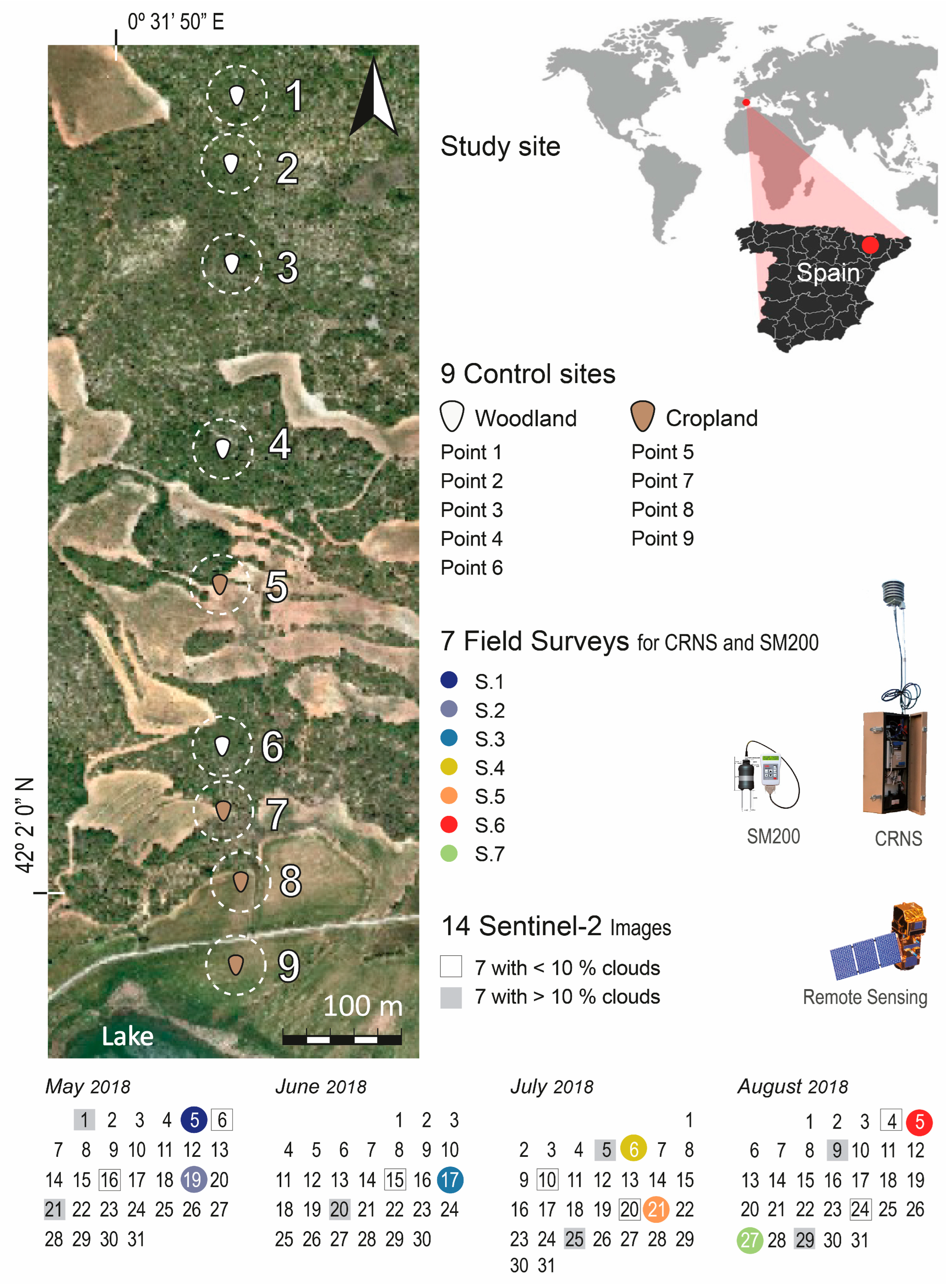
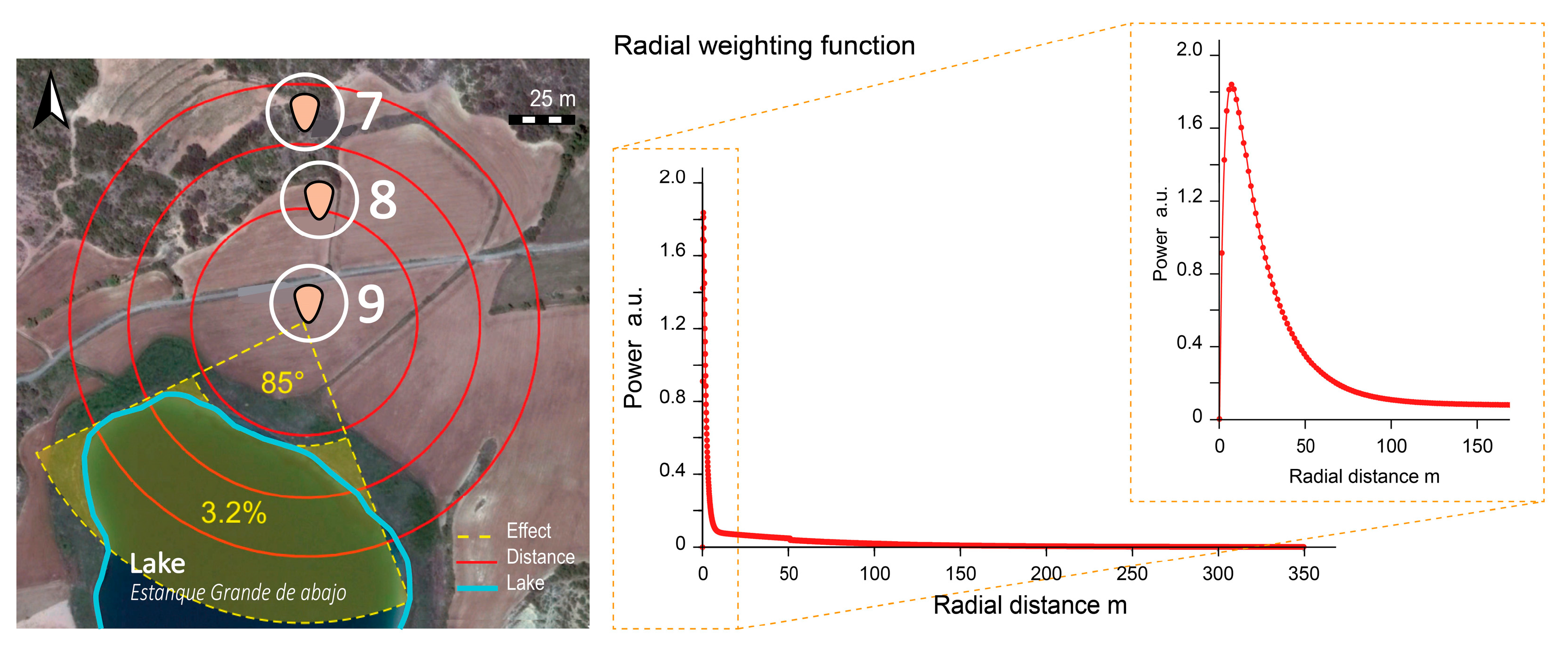
2.1. Study Area, Sampling Design, and Analysis
2.2. Portable CRNS Backpack
2.3. Satellite Imagery Data
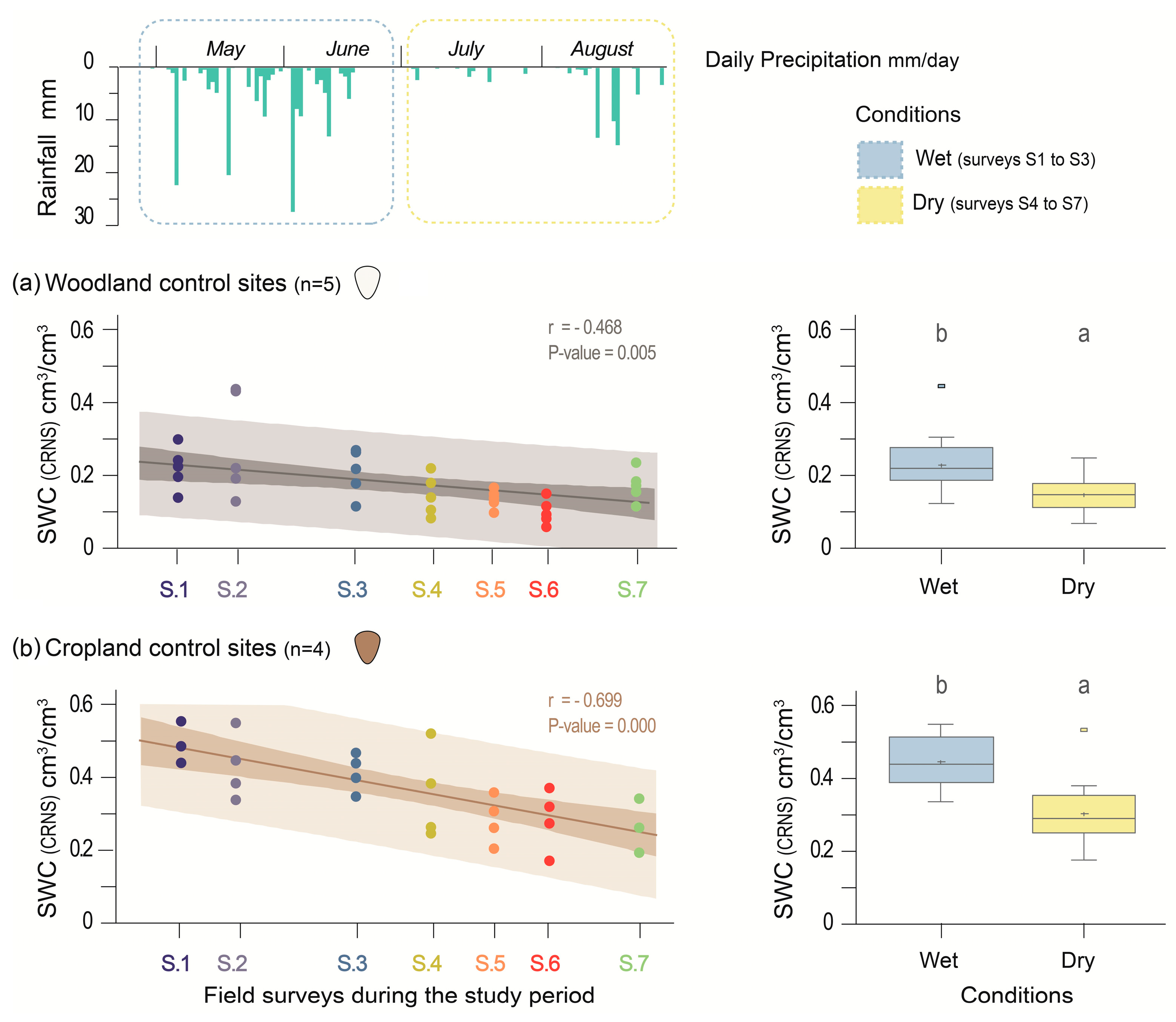
3. Results
3.1. Soil Properties
3.2. Rainfall Pattern
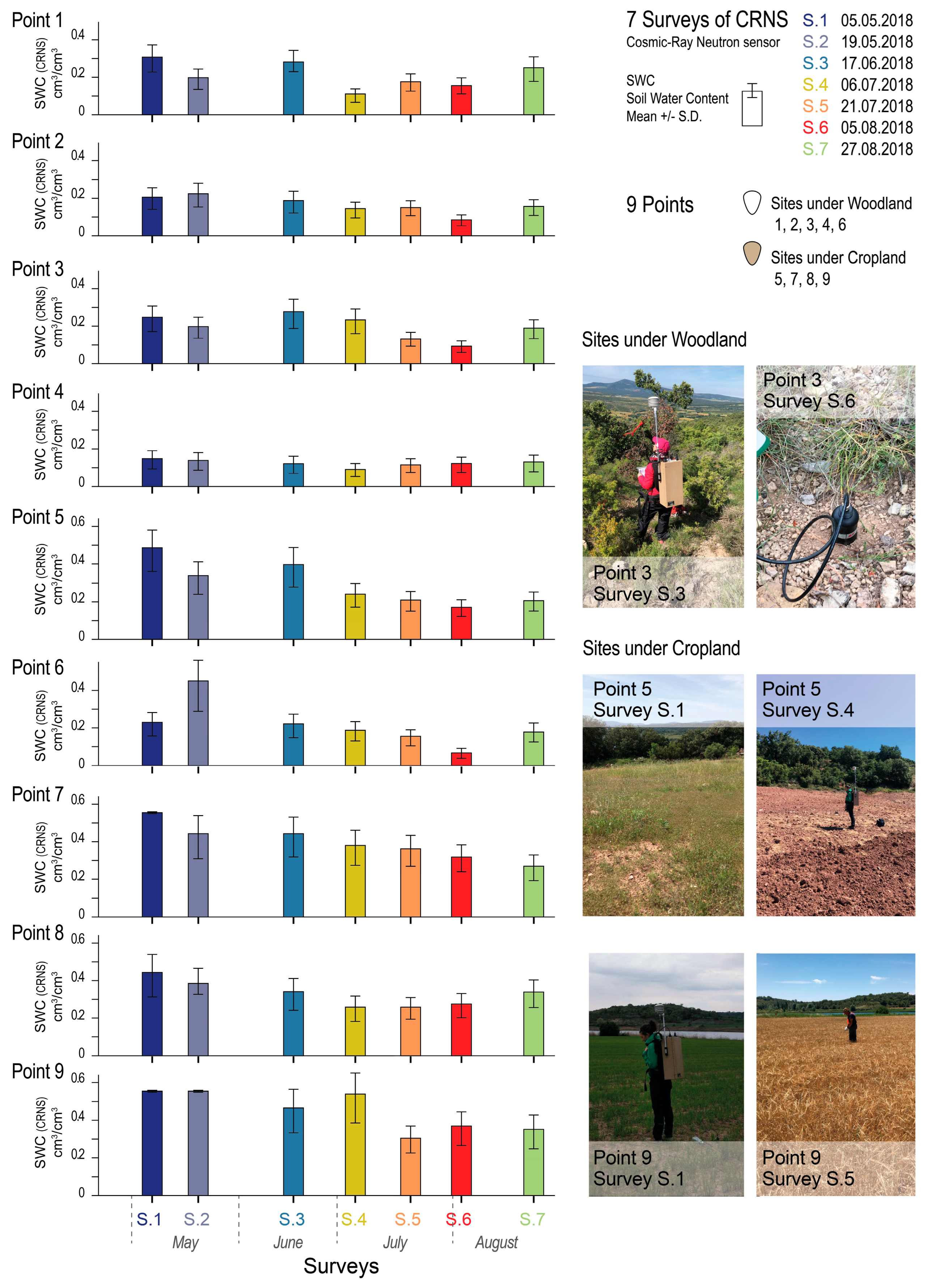
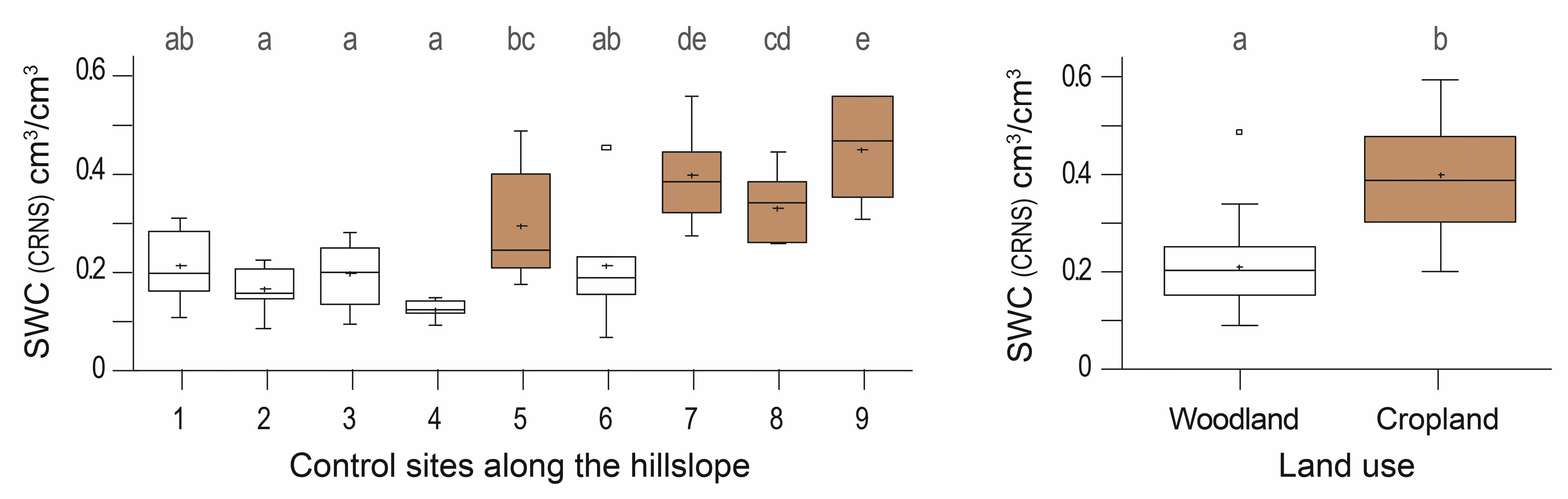
3.3. Cosmic-Ray Neutron Sensor Soil Water Content
3.4. Comparison of Soil Water Content Measurments
4. Discussion
5. Conclusions
Author Contributions
Funding
Data Availability Statement
Acknowledgments
Conflicts of Interest
References
- Konapala, G.; Mishra, A.K.; Wada, Y.; Mann, M.E. Climate change will affect global water availability through compounding changes in seasonal precipitation and evaporation. Nat. Commun. 2020, 11, 3044. [Google Scholar] [CrossRef]
- Crow, W.T.; Berg, A.A.; Cosh, M.H.; Loew, A.; Mohanty, B.P.; Panciera, R.; de Rosnay, P.; Ryu, D.; Walker, J.P. Upscaling sparse ground-based soil moisture observations for the validation of course-resolution satellite soil moisture products. Rev. Geophys. 2012, 50, RG2002. [Google Scholar] [CrossRef]
- Wei, L.; Zhang, B.; Wang, M. Effects of antecedent soil moisture on runoff and soil erosion in alley cropping systems. Agric. Water Manag. 2007, 94, 54–62. [Google Scholar] [CrossRef]
- Ahmad, S.; Kalra, A.; Stephen, H. Estimating soil moisture using remote sensing data: A machine learning approach. Adv. Water Resour. 2010, 33, 69–80. [Google Scholar] [CrossRef]
- Senanayake, I.P.; Yeo, I.Y.; Walker, J.P.; Willgoose, G.R. Estimating catchment scale soil moisture at a high spatial resolution: Integrating remote sensing and machine learning. Sci. Total Environ. 2021, 776, 145924. [Google Scholar] [CrossRef]
- Albergel, C.; De Rosnay, P.; Gruhier, C.; Muñoz-Sabater, J.; Hasenauer, S.; Isaksen, L.; Kerr, Y.; Wagner, W. Evaluation of remotely sensed and modelled soil moisture products using global ground-based in situ observations. Remote Sens. Environ. 2012, 118, 215–226. [Google Scholar]
- Mohanty, B.P.; Cosh, M.H.; Lakshmi, V.; Montzka, C. Soil Moisture Remote Sensing: State-of-the-Science. Vadose Zone J. 2017, 16, 1–9. [Google Scholar] [CrossRef]
- Mekonnen, D.F. Satellite Remote Sensing for Soil Moisture Estimation: Gumara Catchment, Ethiopia. Master’s Thesis, International Institute for Geo-Information Science and Earth Observation (ITC), Enschede, The Netherlands, 2009. [Google Scholar]
- Wang, S.; Chen, H.S.; Fu, Z.; Wang, K. Temporal stability analysis of surface soil water content on two karst hillslopes in southwest China. Environ. Sci. Pollut. Res. 2016, 23, 25267–25279. [Google Scholar] [CrossRef]
- Schönbrodt-Stitt, S.; Ahmadian, N.; Kurtenbach, M.; Conrad, C.; Romano, N.; Bogena, H.R.; Vereecken, H.; Nasta, P. Statistical exploration of SENTINEL-1 data, terrain parameters and in-situ data for Estimating the Near-Surface Soil Moisture in a Mediterranean Agroecosystem. Front. Water 2021, 3, 655837. [Google Scholar] [CrossRef]
- Bogena, H.R.; Huisman, J.A.; Baatz, R.; Hendricks Franssen, H.J.; Vereecken, H. Accuracy of the cosmic-ray soil water content probe in humid forest ecosystems: The worst case scenario. Water Resour. Res. 2013, 49, 5778–5791. [Google Scholar]
- Franz, T.E.; Zreda, M.; Rosolem, R.; Ferre, T.P.A. A universal calibration function for determination of soil moisture with cosmic-ray neutrons. Hydrol. Earth Syst. Sci. 2013, 17, 453–460. [Google Scholar] [CrossRef]
- Zhu, X.; Shao, M.A.; Zeng, C.; Jia, X.; Huang, L.; Zhang, Y.; Zhu, J. Application of cosmic-ray neutron sensing to monitor soil water content in an alpine meadow ecosystem on the northern Tibetan Plateau. J. Hydrol. 2016, 536, 247–254. [Google Scholar] [CrossRef]
- Baroni, G.; Scheiffele, L.M.; Schrön, M.; Ingwersen, J.; Oswald, S.E. Uncertainty, sensitivity and improvements in soil moisture estimation with cosmic-ray neutron sensing. J. Hydrol. 2018, 564, 873–887. [Google Scholar]
- Gaspar, L.; Franz, T.E.; Catalá, A.; Lizaga, I.; Ramos, M.C.; Navas, A. Combining cosmic-ray neutron sensor and fallout 137Cs to explore the connection of soil water content with soil redistribution in an agroforestry hillslope. Environ. Res. 2023, 233, 116451. [Google Scholar] [CrossRef] [PubMed]
- Montzka, C.; Bogena, H.R.; Zreda, M.G.; Monerris, A.; Morrison, R.; Muddu, S.; Vereecken, H. Validation of spaceborne and modelled surface soil moisture products with Cosmic-Ray Neutron Probes. Remote Sens. 2017, 9, 103. [Google Scholar] [CrossRef]
- González-Sanchis, M.; García-Soro, J.M.; Molina, A.J.; Lidón, A.L.; Bautista, I.; Rouzic, E.; Bogena, H.; Hendricks Franssen, H.J.; del Campo, A.D. Comparison of soil water estimates from cosmic-ray neutron and capacity sensors in a semiarid pine forest: Which is able to better assess the role of environmental conditions and thinning? Front. Water. 2020, 2, 39. [Google Scholar] [CrossRef]
- Bogena, H.R.; Schrön, M.; Jakobi, J.; Ney, P.; Zacharias, S.; Andreasen, M.; Baatz, R.; Boorman, D.; Duygu, B.M.; Eguibar-Galán, M.A.; et al. COSMOS-Europe: A European network of Cosmic-Ray Neutron Soil Moisture Sensors. Earth Syst. Sci. Data Discuss. 2021, 14, 1–33. [Google Scholar]
- Joint FAO. Soil Moisture Mapping with a Portable Cosmic Ray Neutron Sensor (No. IAEA-TECDOC-1845); Joint FAO/IAEA Division of Nuclear Techniques in Food and Agriculture: Vienna, Austria, 2018. [Google Scholar]
- Heidbüchel, I.; Güntner, A.; Blume, T. Use of cosmic-ray neutron sensors for soil moisture monitoring in forests. Hydrol. Earth Syst. Sci. 2016, 20, 1269–1288. [Google Scholar] [CrossRef]
- Zreda 2012 Zreda, M.; Shuttleworth, W.J.; Zeng, X.; Zweck, C.; Desilets, D.; Franz, T.; Rosolem, R. COSMOS: The cosmic-ray soil moisture observing system. Hydrol. Earth Syst. Sci. 2012, 16, 4079–4099. [Google Scholar] [CrossRef]
- Shuttleworth, W.J.; Zreda, M.; Zeng, X.; Zweck, C.; Ferré, T.P. The COsmic-ray Soil Moisture Observing System (COSMOS): A non-invasive, intermediate scale soil moisture measurement network. In Proceedings of the British Hydrological Society’s Third International Symposium: “Role of Hydrology in Managing Consequences of a Changing Global Environment”, Newcastle upon Tyne, UK, 19–23 July 2010. [Google Scholar]
- Jiao, Q.; Zhu, Z.; Du, F. Theory and application of measuring mesoscale soil moisture by cosmic-ray fast neutron probe. 35th International Symposium on Remote Sensing of Environment (ISRSE35). IOP Conf. Ser. Earth Environ. Sci. 2014, 17, 012147. [Google Scholar] [CrossRef]
- Jakobi, J.; Huisman, J.A.; Vereecken, H.; Diekkrüger, B.; Bogena, H.R. Cosmic-ray neutron sensing for simultaneous soil water content and biomass quantification in drought conditions. Water Resour. Res. 2018, 54, 7383–7402. [Google Scholar] [CrossRef]
- Desilets, D.; Zreda, M.; Ferré, T.P.A. Nature’s Neutron Probe: Land Surface Hydrology at an Elusive Scale with Cosmic Rays. Water Resour. Res. 2010, 46, W11505. [Google Scholar] [CrossRef]
- Franz, T.E.; Wahbi, A.; Vreugdenhil, M.; Weltin, G.; Heng, L.; Oismueller, M.; Strauss, P.; Dercon, G.; Desilets, D. Using cosmic-ray neutron probes to monitor landscape scale soil water content in mixed land use agricultural systems. Appl. Environ. Soil Sci. 2016, 2016, 4323742. [Google Scholar]
- Haubrock, S.N.; Chabrillat, S.; Kuhnert, M.; Hostert, P.; Kaufmann, H. Surface soil moisture quantification and validation based on hyperspectral data and field measurements. J. Appl. Remote Sens. 2008, 2, 023552. [Google Scholar] [CrossRef]
- Schrön, M.; Zacharias, S.; Womack, G.; Köhli, M.; Desilets, D.; Oswald, S.E.; Bumberger, J.; Mollenhauer, H.; Kögler, S.; Remmler, P.; et al. Intercomparison of cosmic-ray neutron sensors and water balance monitoring in an urban environment. Geosci. Instrum. Method. Data Syst. 2018, 7, 83–99. [Google Scholar]
- Baskan, O.; Kosker, Y.; Erpul, G. Spatial and temporal variation of moisture content in the soil profiles of two different agricultural fields of semi-arid region. Environ. Monit Assess. 2013, 185, 10441–10458. [Google Scholar] [PubMed]
- Gaspar, L.; Lizaga, I.; Navas, A. Spatial distribution of fallout and lithogenic radionuclides controlled by soil carbon and water erosion in an agroforestry South-Pyrenean catchment. Geoderma 2021, 391, 114941. [Google Scholar]
- Valentino, R.; Montrasio, L.; Losi, G.L.; Bittelli, M. An empirical model for the evaluation of the degree of saturation of shallow soils in relation to rainfalls. Can. Geotech. J. 2011, 48, 795–809. [Google Scholar] [CrossRef]
- Renard, K.G.; Foster, G.R.; Weesies, G.A.; McCool, D.K.; Yoder, D.C. Predicting soil erosion by water, a guild to conservation planning with the Revised Universal Soil Loss Equation (RUSLE). In USDA Agricultural Handbook; No. 703; U.S. Government Printing Office: Washington, DC, USA, 1997. [Google Scholar]
- Poesen, J.; Lavee, H. Rock fragments in topsoils: Significance and processes. Catena 1994, 23, 1–28. [Google Scholar]
- Van Wesemael, B.; Poesen, J.; Kosmas, C.S.; Danalatos, N.G.; Nachtergaele, J. Evaporation from cultivated soils containing rock fragments. J. Hydrol. 1996, 182, 65–82. [Google Scholar]
- Tetegan, M.; Nicoullaud, B.; Baize, D.; Bouthier, A.; Cousin, I. The contribution of rock fragments to the available water content of stony soils: Proposition of new pedotransfer functions. Geoderma 2011, 165, 40–49. [Google Scholar]
- Ly, L.; Franz, T.T.; Robinson, D.A.; Jones, S.B. Measured and Modeled Soil Moisture Compared with Cosmic-Ray Neutron Probe Estimates in a Mixed Forest. Vadose Zone J. 2014, 13, 1–12. [Google Scholar]
- West, H.; Quinn, N.; Horswell, M.; White, P. Assessing vegetation response to soil moisture fluctuation under extreme drought using sentinel-2. Water 2018, 10, 838. [Google Scholar] [CrossRef]
- McFeeters, S.K. The Use of the Normalized Difference Water Index (NDWI) in the Delineation of Open Water Features. Int. J. Remote Sens. 1996, 17, 1425–1432. [Google Scholar]
- Said, H.; Mbaye, M.; Heng, L.K.; Weltin, G.; Franz, T.; Dercon, G.; Toloza, A.; Strauss, P.; Rab, G. High-resolution soil moisture retrieval using C-band radar Sentinel-1 and Cosmic-ray neutron sensor data. In Proceedings of the 2021 IEEE International Workshop on Metrology for Agriculture and Forestry (MetroAgriFor), Trento-Bolzano, Italy, 3–5 November 2021; pp. 221–225. [Google Scholar]


| Survey | Date 2018 | Sensor | Scene ID No. |
|---|---|---|---|
| S1 | 6 May | S2B | L2A_20180506T105029_N0207_R051_T31TBG_20180509T155709 |
| S2 | 16 May | S2B | L2A_20180516T105029_N0207_R051_T31TBG_20180516T125357 |
| S3 | 15 June | S2B | L2A_20180615T105029_N0208_R051_T31TBG_20180615T142918 |
| S4 | 10 July | S2A | L2A_20180710T105031_N0208_R051_T31TBG_20180710T141216 |
| S5 | 20 July | S2B | L2A_20180720T105031_N0208_R051_T31TBG_20180720T135744 |
| S6 | 4 August | S2B | L2A_20180804T105019_N0208_R051_T31TBG_20180804T173100 |
| S7 | 24 August | S2B | L2A_20180824T105019_N0208_R051_T31TBG_20180824T165733 |
| Sites | Use | Depth, | Stones, | Bulk Density, | SOC, | Clay, | Lattice Water, |
|---|---|---|---|---|---|---|---|
| cm | % | g/cm3 | % | % | g/g | ||
| Point 1 | Woodland | 15 | 33.3 | 1.080 | 7.85 | 6.06 | 0.0125 |
| Point 2 | Woodland | 20 | 13.3 | 1.030 | 5.80 | 26.10 | 0.0097 |
| Point 3 | Woodland | 35 | 46.9 | 1.780 | 3.41 | 15.90 | 0.0249 |
| Point 4 | Woodland | 28 | 50.0 | 1.290 | 9.33 | 19.02 | 0.0181 |
| Point 5 | Cropland | 47 | 34.8 | 1.400 | 1.30 | 30.73 | 0.0184 |
| Point 6 | Woodland | 40 | 30.8 | 1.870 | 3.00 | 19.93 | 0.0147 |
| Point 7 | Cropland | 43 | 32.1 | 1.640 | 1.40 | 21.24 | 0.0187 |
| Point 8 | Cropland | 45 | 15.4 | 1.620 | 1.61 | 20.36 | 0.0177 |
| Point 9 | Cropland | 53 | 16.0 | 1.660 | 1.22 | 25.24 | 0.0114 |
| SWC (cm3/cm3) | Neutrons (cpm) | ||||||
|---|---|---|---|---|---|---|---|
| Survey | Date 2018 | Soil Condition | Points | n | Mean ± SD | Range | Mean ± SD |
| S1 | 5 May | Wet | All | 9 | 0.35 ± 0.16 | 0.1460–0.5500 | 22.0 ± 1.6 |
| Woodland | 5 | 0.23 ± 0.06 | 0.1460–0.3063 | 23.1 ± 0.4 | |||
| Cropland | 4 | 0.51 ± 0.05 | 0.4389–0.5500 | 20.5 ± 1.3 | |||
| S2 | 19 May | Wet | All | 9 | 0.32 ± 0.14 | 0.1385–0.5500 | 22.2 ± 1.7 |
| Woodland | 5 | 0.24 ± 0.12 | 0.1385–0.4475 | 22.7 ± 1.5 | |||
| Cropland | 4 | 0.43 ± 0.09 | 0.3350–0.5500 | 21.6 ± 1.8 | |||
| S3 | 17 June | Wet | All | 9 | 0.30 ± 0.12 | 0.1207–0.4619 | 22.9 ± 0.9 |
| Woodland | 5 | 0.22 ± 0.07 | 0.1207–0.2784 | 23.4 ± 0.8 | |||
| Cropland | 4 | 0.41 ± 0.05 | 0.3364–0.4619 | 22.2 ± 0.5 | |||
| S4 | 6 July | Dry | All | 9 | 0.24 ± 0.14 | 0.0894–0.5358 | 24.1 ± 1.8 |
| Woodland | 5 | 0.15 ± 0.06 | 0.0894–0.2339 | 24.9 ± 1.8 | |||
| Cropland | 4 | 0.35 ± 0.14 | 0.2407–0.5358 | 23.1 ± 1.6 | |||
| S5 | 21 July | Dry | All | 9 | 0.20 ± 0.08 | 0.1130–0.3583 | 24.6 ± 0.9 |
| Woodland | 5 | 0.14 ± 0.02 | 0.1130–0.1744 | 25.0 ± 0.6 | |||
| Cropland | 4 | 0.28 ± 0.06 | 0.2074–0.3583 | 24.1 ± 0.9 | |||
| S6 | 5 August | Dry | All | 9 | 0.18 ± 0.11 | 0.0658–0.3640 | 25.4 ± 1.7 |
| Woodland | 5 | 0.10 ± 0.04 | 0.0658–0.1576 | 26.4 ± 1.3 | |||
| Cropland | 4 | 0.28 ± 0.08 | 0.1715–0.3640 | 24.1 ± 1.3 | |||
| S7 | 27 August | Dry | All | 9 | 0.23 ± 0.08 | 0.1245–0.3485 | 24.0 ± 0.7 |
| Woodland | 5 | 0.18 ± 0.05 | 0.1245–0.2487 | 24.1 ± 0.2 | |||
| Cropland | 4 | 0.29 ± 0.07 | 0.2046–0.3485 | 23.9 ± 1.0 | |||
| (a) | Surveys | Period | |||||||||||
|---|---|---|---|---|---|---|---|---|---|---|---|---|---|
| p-Value | S1 | S2 | S3 | S4 | S5 | S6 | S7 | p-Value | Dry | Wet | |||
| Point 1 | 0.0061 | 4 | 6 | 5 | 2 | 7 | 3 | 1 | 0.0103 | a | b | ||
| a | ab | ab | abc | bcd | cd | d | |||||||
| Point 2 | 0.0459 | 6 | 4 | 5 | 7 | 3 | 1 | 2 | 0.0023 | a | b | ||
| a | ab | ab | ab | b | b | b | |||||||
| Point 3 | 0.0123 | 6 | 5 | 7 | 2 | 4 | 1 | 3 | 0.0161 | a | b | ||
| a | ab | abc | bc | c | c | c | |||||||
| Point 4 | 0.7253 | 4 | 5 | 6 | 3 | 7 | 2 | 1 | 0.1618 | a | a | ||
| a | a | a | a | a | a | a | |||||||
| Point 5 | 0.0012 | 6 | 7 | 5 | 4 | 2 | 3 | 1 | 0.0000 | a | b | ||
| a | ab | ab | ab | bc | cd | d | |||||||
| Point 6 | 0.0003 | 6 | 5 | 7 | 4 | 3 | 1 | 2 | 0.0028 | a | b | ||
| a | ab | ab | b | b | b | c | |||||||
| Point 7 | 0.0242 | 7 | 6 | 5 | 4 | 3 | 2 | 1 | 0.0012 | a | b | ||
| a | ab | ab | ab | bc | bc | c | |||||||
| Point 8 | 0.0918 | 5 | 4 | 6 | 7 | 3 | 2 | 1 | 0.0062 | a | b | ||
| a | a | a | ab | ab | ab | b | |||||||
| Point 9 | 0.0104 | 5 | 7 | 6 | 3 | 4 | 2 | 1 | 0.0137 | a | b | ||
| a | ab | ab | bc | c | c | c | |||||||
| (b) | Control Points | Land Use | |||||||||||
| p-Value | P1 | P2 | P3 | P4 | P5 | P6 | P7 | P8 | P9 | p-Value | Wood. | Crop. | |
| Survey 1 | 0.0000 | 4 | 2 | 6 | 3 | 1 | 8 | 5 | 7 | 9 | 0.0000 | a | b |
| a | ab | ab | ab | b | c | c | c | c | |||||
| Survey 2 | 0.0001 | 4 | 1 | 3 | 2 | 5 | 8 | 7 | 6 | 9 | 0.0007 | a | b |
| a | ab | ab | ab | bc | c | cd | cd | d | |||||
| Survey 3 | 0.0007 | 4 | 2 | 6 | 3 | 1 | 8 | 5 | 7 | 9 | 0.0000 | a | b |
| a | ab | abc | bcd | bcd | cde | de | e | e | |||||
| Survey 4 | 0.0000 | 4 | 1 | 2 | 6 | 3 | 5 | 8 | 7 | 9 | 0.0001 | a | b |
| a | ab | ab | ab | b | b | b | c | d | |||||
| Survey 5 | 0.0002 | 4 | 3 | 2 | 6 | 1 | 5 | 8 | 9 | 7 | 0.0000 | a | b |
| a | ab | ab | ab | abc | bc | cd | de | e | |||||
| Survey 6 | 0.0000 | 6 | 2 | 3 | 4 | 1 | 5 | 8 | 7 | 9 | 0.0000 | a | b |
| a | ab | ab | ab | b | b | c | cd | d | |||||
| Survey 7 | 0.0019 | 4 | 2 | 6 | 3 | 5 | 1 | 7 | 8 | 9 | 0.0005 | a | b |
| a | ab | abc | abc | abc | bcd | cd | d | d | |||||
| (a) Spatial Factor: Point Location | (b) Temporal Factor: Survey Day | ||||||
|---|---|---|---|---|---|---|---|
| Survey | R2 | MAE | p-Value | Point | R2 | MAE | p-Value |
| Survey 1 | 86.95 | 0.041 | 0.0000 | Point 6 | 80.15 | 0.042 | 0.0003 |
| Survey 6 | 85.84 | 0.033 | 0.0000 | Point 5 | 75.39 | 0.051 | 0.0012 |
| Survey 4 | 84.82 | 0.045 | 0.0001 | Point 1 | 68.27 | 0.038 | 0.0061 |
| Survey 2 | 80.39 | 0.050 | 0.0001 | Point 9 | 65.39 | 0.049 | 0.0104 |
| Survey 5 | 77.23 | 0.035 | 0.0002 | Point 3 | 64.46 | 0.038 | 0.0123 |
| Survey 3 | 72.98 | 0.056 | 0.0007 | Point 7 | 60.24 | 0.053 | 0.0242 |
| Survey 7 | 69.56 | 0.041 | 0.0019 | Point 2 | 55.63 | 0.032 | 0.0459 |
| Point 8 | 49.80 | 0.055 | 0.0918 | ||||
| Point 4 | 20.49 | 0.029 | 0.7253 | ||||
Disclaimer/Publisher’s Note: The statements, opinions and data contained in all publications are solely those of the individual author(s) and contributor(s) and not of MDPI and/or the editor(s). MDPI and/or the editor(s) disclaim responsibility for any injury to people or property resulting from any ideas, methods, instructions or products referred to in the content. |
© 2025 by the authors. Licensee MDPI, Basel, Switzerland. This article is an open access article distributed under the terms and conditions of the Creative Commons Attribution (CC BY) license (https://creativecommons.org/licenses/by/4.0/).
Share and Cite
Gaspar, L.; Franz, T.E.; Navas, A. Cosmic-Ray Neutron Sensor Backpack for Assessing Spatial and Temporal Variations in Soil Water Content in an Agroforestry System in Northern Spain. Land 2025, 14, 744. https://doi.org/10.3390/land14040744
Gaspar L, Franz TE, Navas A. Cosmic-Ray Neutron Sensor Backpack for Assessing Spatial and Temporal Variations in Soil Water Content in an Agroforestry System in Northern Spain. Land. 2025; 14(4):744. https://doi.org/10.3390/land14040744
Chicago/Turabian StyleGaspar, Leticia, Trenton E. Franz, and Ana Navas. 2025. "Cosmic-Ray Neutron Sensor Backpack for Assessing Spatial and Temporal Variations in Soil Water Content in an Agroforestry System in Northern Spain" Land 14, no. 4: 744. https://doi.org/10.3390/land14040744
APA StyleGaspar, L., Franz, T. E., & Navas, A. (2025). Cosmic-Ray Neutron Sensor Backpack for Assessing Spatial and Temporal Variations in Soil Water Content in an Agroforestry System in Northern Spain. Land, 14(4), 744. https://doi.org/10.3390/land14040744