Article

Flood-Hazard Assessment in the Messapios River Catchment (Central Evia Island, Greece) by Integrating GIS-Based Multi-Criteria Decision Analysis and Analytic Hierarchy Process

by
Vasileios Mazarakis
1,
Konstantinos Tsanakas
1,
Noam Greenbaum
2,
Dimitrios-Vasileios Batzakis
1,
Alessia Sorrentino
3,
Ioannis Tsodoulos
1,
Kanella Valkanou
1 and
Efthimios Karymbalis
1,*
1
Department of Geography, Harokopio University, GR-17671 Athens, Greece
2
School of Environmental Sciences, University of Haifa, 199 Aba Khoushy Ave., Mount Carmel, Haifa 3498838, Israel
3
Department of Science and Technology, Università degli Studi di Napoli Parthenope, Centro Direzionale Is. C4, 80121 Naples, Italy
*
Author to whom correspondence should be addressed.
Land 2025, 14(3), 658; https://doi.org/10.3390/land14030658
Submission received: 7 February 2025 / Revised: 7 March 2025 / Accepted: 15 March 2025 / Published: 20 March 2025

Abstract

:
This study presents a comprehensive flood-hazard assessment and mapping of the Messapios River catchment in Evia Island, Greece, utilizing a combination of Multi-Criteria Decision Analysis (MCDA) and Geographic Information Systems (GISs). Flood-prone zones were identified based on five critical factors, which were determined to be the most influential in the watercourse when excessive discharge overwhelms the drainage network’s capacity: slope, elevation, proximity to stream channels, geological formations, and land cover. The Analytic Hierarchy Process (AHP) was applied to assign weights to these factors, while the final flood-hazard map was generated using the Weighted Linear Combination (WLC) method. The analysis revealed that 17.8% of the catchment, approximately 39 km2, falls within a very high flood-hazard zone, while 18.02% (38.91 km2) is classified as highly susceptible to flooding. The flood-prone areas are concentrated in the central, southern, and western parts of the study area, particularly at the lower reaches of the catchment, on both sides of the main streams’ channels, and within the gently sloping, low-lying fan delta of the river. The study area has high exposure to flood hazards due to the significant population of approximately 9000 residents living within the flood-prone zones, a fact that contributes to the area’s potential vulnerability. Additionally, critical infrastructure, including five industrial facilities, the Psachna General High School, the local Public Power Corporation substation, about 21 km of the road network, and 21 bridges are located within the zones classified as having high and very high flood-hazard levels. Furthermore, about 35 km2 of economically vital agricultural areas (such as parts of the Psachna and Triada plains) are situated in highly and very highly prone to floods zones. MCDA proved to be an effective and reliable approach for assessing and mapping flood-hazard distribution in the Messapios River catchment. The results provide valuable insights to assist decision-makers in prioritizing intervention areas and efficiently allocate resources.

1. Introduction

Floods are among the most frequent and devastating natural hazards worldwide, responsible for the majority of fatalities caused by natural disasters. In recent decades, the frequency of extreme flood events has increased significantly, resulting in a wide range of impacts across various sectors of society. Some of these effects are immediate and highly visible, including the loss of human lives and property, the destruction of infrastructure, and negative consequences for the natural environment [1], while others are indirect and emerge over time, such as health issues arising from pollution associated with the flooding and financial hardships faced by individuals who lose their property due to flood-related destruction.
According to the Centre for Research on the Epidemiology of Disasters (CRED, 2023) [2], the annual average occurrence of natural-hazards-related disasters during the period from 2003 to 2022 was 369 with the majority (170 events) being floods. These flood events caused an annual average of 5518 fatalities, affected a total of 74.6 million people, and resulted in economic losses amounting to USD 41.1 billion. In 2023, a total of 164 flood events occurred worldwide, accounting for a significant portion of the 399 recorded natural-hazard-related disasters. These floods caused 7763 fatalities and affected 32.4 million people, with economic losses amounting to 20.4 USD billion. One of the most catastrophic events of the year was storm Daniel, which struck Libya and other Mediterranean countries in September [3,4]. The resulting floods caused 12,352 casualties, including 8000 missing persons, and led to economic losses of USD 6.2 billion. This disaster was the second deadliest of 2023, surpassed only by the Türkiye and Syria earthquakes. The costliest floods of the year occurred in mid-May in Italy’s Emilia-Romagna region [5,6,7], where, in addition to 15 fatalities, they resulted in economic damages estimated at USD 9.8 billion.
Greece ranks fourth among Eastern Mediterranean countries in the occurrence of catastrophic and deadly flash floods during the period 1882 to 2021, with 12 such events causing more than ten fatalities each [8,9]. The increasing frequency and intensity of flood events in Greece and globally, along with their growing impact, highlights the urgent need to understand their underlying drivers and support efforts to mitigate flood risks and enhance resilience. As part of these initiatives, flood-hazard assessment and mapping are crucial tools for prevention and efficient spatial management.
In many research approaches, scientists are required to make decisions on various problems. These decisions can range from simple matters to more complex issues. In making these decisions, different criteria or alternatives are always taken into account, and sometimes, even for the same problem, different decisions are likely to be made. The more complex the issue under consideration, the more criteria that have to be taken into account in making the final decision, often leading to a conflict of opinion. For this reason, the need arises to find a standardized decision-making process. The Multi-Criteria Decision Analysis (MCDA) is a decision-making tool that aims to define and formulate those standardized procedures that will help decision-makers to solve the problems they are considering by linking them to the factors they are related to. A structured decision-making framework designed to assist in complex decision-making scenarios is the Analytic Hierarchy Process (AHP). It uses pairwise comparisons to prioritize and rank alternatives or criteria according to their relative importance [10,11].
GIS-based MCDA techniques have gained significant traction in addressing spatial planning and management challenges. These methodologies are extensively used across various geoscience disciplines, including analyses of landslide susceptibility [12,13], evaluations of neotectonic deformation [14,15], assessment of soil erosion [16,17], and studies focused on flood risk assessment and mapping [18,19,20]. Many methodological approaches to flood-hazard assessment integrate MCDA with the Analytical Hierarchy Process (AHP) to enhance decision-making accuracy and robustness [21,22,23,24].
Recent advancements in GIS and Digital Elevation Models (DEMs) have significantly improved flood-hazard assessments, enabling more precise and detailed zoning. By integrating topographic, hydrological, and physical data, state-of-the-art approaches enhance flood predictions and the accuracy of hazard mapping. For instance, GFPLAIN is a global database that offers floodplain mapping at a 250 m resolution, using geomorphic algorithms to extract the floodplains from Digital Terrain Models (DTMs) [25]. Similarly, RESCUE is a DTM-based modeling framework that couples hydrologic and hydraulic simulations to produce flood maps at a large scale [26]. Moreover open-source GIS tools, such as the Geomorphic Flood Area (GFA) tool, provide flood-prone area mapping by combining geomorphological data extracted from DEMs with flood-hazard information from existing flood studies, using them as training areas [27].
This paper aims to assess and map flood hazard in the catchment of Messapios River, a flood-prone area in the central part of Evia Island, Greece. For this purpose, a GIS-based MCDA methodology, supported by high-resolution DEM data, was applied, incorporating factors/criteria identified as critical contributors to flooding. These factors significantly influence the water route when the drainage system’s capacity is surpassed by heavy runoff and have been shown to be effective in similar flood-hazard assessment methodological approaches [1,18,28,29,30]. The weight of each factor/criterion was determined using the AHP after ranking them according to their relative importance based on experts’ experience in flood-hazard assessments.
In Greece, numerous research studies employ GIS-based MCDA methods to identify and evaluate flood-prone areas. These approaches have been across various regions, including the Rhodope-Evros area and the Kassandra Peninsula in northern Greece [18,31], Thessaly in central Greece [32], and the Peloponnese in southern Greece [33,34,35]. Furthermore, GIS-based MCDA techniques have been utilized for flood-hazard assessment and mapping in the urban area of Athens [28], the broader Attica Region [30], the Megalo Rema River catchment in East Attica [1], and the fire-affected northeastern urban areas of the Attica Prefecture [36]. These studies demonstrate the effectiveness of GIS-based MCDA in flood-hazard mapping, highlighting its applicability in regions with complex topography and hydrology, such as the Messapios River catchment.

2. Study Area

The Messapios River is an ephemeral stream located in the central part of Evia Island, Greece. The total length of its main channel is approximately 34 km. For the first 18 km, it flows in a northeast-to-southwest direction, then shifts to a southeast-to-northwest flow for the next 9 km. In its final stretch of 7 km, before emptying into the North Evoikos Gulf, it resumes a southeast-to-northwest flow. The Messapios River catchment covers a total area of 215.96 km2 and is surrounded by high mountains characterized by steep slopes and rugged relief. It reaches a maximum elevation of 1743 m at its northeastern boundary, on the western slopes of Mount Dirfys (Figure 1). The average slope of the catchment is 24.1%, with the steepest relief found in the upstream mountainous and semi-mountainous regions to the north and northeast, favoring surface runoff. In contrast, the lowland area of the extensive fan delta at the river’s mouth is characterized by gentle slopes, which promote sediment deposition and enhance rainwater infiltration.
The study area consists of geological formations belonging to the Sub-Pelagonian geotectonic zone, including ophiolites of Upper Jurassic—Lower Cretaceous age, Upper Cretaceous limestones, and flysch formations of Upper Cretaceous—Paleocene age. Parts of the catchment are composed of alternating Neogene layers of conglomerates, marls, clays, and sandstones of lacustrine origin [37]. The lower reaches of the catchment, along with the low-lying plains on both sides of the main channels of the drainage network, consist of recent (Holocene) alluvial deposits.
The climate of the study area is classified as subtropical Mediterranean, characterized by long, hot, and dry summers, followed by mild and wet winters. The mean annual precipitation is approximately 450 mm, and the mean annual air temperature is around 17 °C [38]. The rainy season starts in October and lasts until March.
Hydrologically, the Messapios River catchment is part of the Eastern Sterea Hellas Water District (EL07). Within this District, a total of 181 flood events were recorded between 1939 and 2018, 40 of which were classified as significant (Special Secretariat of Water, Ministry of Environment and Energy, 2017). In the Municipality of Dirfys-Messapia, 13 events were recorded (approximately 7% of the total), with 12 of them classified as significant [39]. The most notable and relatively recent flood events in the area occurred in 1998, 2002, 2006, 2009, and 2020, causing significant impacts across many municipalities, particularly in Dirfys-Messapia. The flash flood on 30 October 2006 severely affected the settlements of Psachna, Makrykapa, and Kastella, located within the study area. The most recent severe flash flood, which impacted many areas of central Evia Island, including parts of the Messapios River catchment, occurred on 9 August 2020, and was triggered by an extreme weather event named “Thalia”. Eight people lost their lives, more than 2500 houses and several businesses were damaged, and extensive farmland was completely destroyed. Critical infrastructure also suffered severe damage, including considerable destruction to the road network, bridges, the electricity transmission network, and sections of the water supply system serving local settlements.
Administratively, the Messapios River catchment falls under the jurisdiction of the Municipality of Dirfys-Messapia within the Evia Regional Unit. According to the 2021 census, the Municipality has a population of 15,934 inhabitants. Over half of the residents (8292) live in the low-lying areas comprising the plains of Psachna-Kastella and Triada. The main settlements within the Messapios River catchment are Psachna, the administrative center of the Municipality, with 5827 inhabitants, Kastella with 1416, Triada with 1049, and Makrykapa with 804 residents. Approximately 35% of the population are professional farmers who cultivate the fertile plains of Triada and Psachna—Kastella, as well as olive trees found in most lowland and semi-mountainous areas of the catchment. Additionally, many households supplement their income with agricultural and livestock activities. Therefore, the population is primarily characterized as rural with the primary sector being the main economic pillar of the Municipality [40].

3. Materials and Methods

3.1. Flood-Hazard Criteria

The purpose of this study is to assess and map flood risk in the Messapios River catchment. To achieve this, a model was developed that combines the methods of MCDA and the AHP. This combination facilitated the integration and calibration of five key factors/criteria: slope, elevation, distance from higher-order stream channels, land cover, and hydro-lithological characteristics of the geological formations (Figure 2). These factors/criteria influence water flow when the drainage system’s capacity is exceeded due to high runoff and their selection was based on a review of similar methodological approaches in the international literature [1,18,28,30,36,41,42]. Initially, each factor was divided into five classes with specific boundary values. Subsequently, they were reclassified and expressed on a unified scale ranging from 1 to 5, based on the hazard level each criterion contributes to the overall flood hazard. The class rated as “1” represents a very low flood-hazard level, whereas the class rated as “5” indicates a very high flood-hazard level. Each of the five factors used in the flood-hazard assessment was depicted through a spatial distribution thematic map, with the values first classified and then standardized to a consistent scale.

3.1.1. Slope

The slope of the terrain is a critical factor in the occurrence of flooding. Steep slopes favor surface runoff, as water moves away from these areas relatively quickly, resulting in very low potential to flooding. In contrast, areas with gentle slopes tend to accumulate surface runoff from adjacent steep slopes more easily, significantly increasing their proneness of flooding.
The slope analysis of the study area was computed using ArcGIS/ArcMap 10.8.2 ESRI® software, with elevation data sourced from a high-resolution 5 m DEM provided by the Hellenic Cadastre (Ktimatologio S.A.). The computed slope was initially represented as a 5 m resolution raster layer, which was later converted into a vector layer to depict the terrain’s steepness in degrees. Slope values were categorized into five classes and assigned ratings from 1 to 5. Gentle slopes (<5° and 5–15°) were identified as areas with very high and high flood susceptibility, receiving ratings of 5 and 4, respectively. Moderate slopes (15–25°) were rated 3, indicating moderate flood proneness, while areas with steeper slopes (25–40° and >40°) were considered to have low and very low flood proneness, assigned ratings of 2 and 1, respectively.

3.1.2. Elevation

Elevation is a significant factor in the occurrence of floods [43,44,45], as due to gravity, water flows swiftly from higher elevations to lower-lying areas leading to flooding [46]. However, there is no standard elevation threshold for defining a flood risk boundary, as it varies across regions and depends on the morphological characteristics of each catchment [1]. Most flood events recorded within the Messapios River catchment have occurred in areas with very low elevations, such as Psachna and Kastella (20 m), whereas some have also been noted in higher-elevation areas like Makrykapa (170 m).
The elevation grid for the study area was derived from the 5 m resolution DEM. Elevation values were classified into five categories based on the analysis of past flood events within the catchment. The lower elevation zones (0–150 m), identified as the most susceptible to flooding, were assigned the highest rating of 5, while areas with elevations of 151–300, 301–500, 501–900, and 901–1717 m were assigned ratings of 4, 3, 2, and 1, respectively.

3.1.3. Distance from Stream Channels

The distance from the drainage network is a very significant criterion of flood-risk assessment [47]. During a heavy rainfall event, river overflow can pose a major threat to areas located near the river channel, which are at high risk of flooding, whereas areas farther from the river channel face a much lower risk [1,48]. It is evident that no universally accepted threshold exists for the critical distance linked to higher flood susceptibility, as this distance varies between rivers depending on their size and discharge capacity. In this study, the factor of “distance from the stream channel” was considered proportionally, drawing comparisons with distances used in similar studies and aligning them with the catchment size (see [18,28]). Historical flood records in the study area and the “flood risk management plans” by the Special Secretariat of Water of the Ministry of Environment and Energy [39] were essential in defining the categories for this criterion. In this study, we assumed that the higher the Strahler order of the stream channel, the greater the distance for each flood-hazard category [1,28]. Flood-hazard levels and assigned ratings decrease with increasing distance and rise as the distance shortens.
Flow accumulation is proportional to the Strahler order. Therefore, 1st and 2nd order streams were excluded due to their very low flow accumulation. For 3rd order stream channels, buffer zones were delineated at distances of 0–20, 20–40, 40–60, 60–80, and >80 m. Around 4th order stream channels, buffer zones were established at distances of 0–30, 30–60, 60–80, 80–100, and >100 m. For the two 5th order streams, buffer zones were defined at distances of 0–40, 40–80, 80–100, 100–120, and >120 m from the channels of the two main tributaries of Messapios River. For the main channel of the Messapios River, classified as a 6th order channel, buffer zones were set at distances of 0–50, 50–100, 100–130, 130–150, and >150 m.
The drainage network of the Messapios River was extracted from the high-resolution 5 m DEM of the area provided by the Hellenic Cadastre (Ktimatologio S.A.) using the ArcGIS/ArcMap ESRI® software. The same software was used to rank the drainage network stream channels according to Strahler’s stream order system [49]. To determine this, factor buffer zones were generated in the ArcMap interface, creating polygons around both sides of stream channels of higher than 3rd order at specified distances.

3.1.4. Land Cover

Land cover is a crucial determinant in assessing flood risk, as the specific characteristics of each type play a significant role in regulating hydrological processes such as surface runoff, infiltration rate, and evapotranspiration [1,50].
The land cover types were classified into five categories. Forested areas and areas occupied by semi-natural vegetation favor infiltration and also act as natural barriers that slow and obstruct surface runoff. Consequently, they are categorized as areas of low and very low flood proneness, with assigned ratings of 2 and 1, respectively. Agricultural and cultivated lands allow for greater surface runoff compared to the natural vegetation categories and are classified as areas of moderate flood proneness, with an assigned rating of 3. Finally, non-irrigated arable land and artificial surfaces (e.g., urban and industrial areas) are impermeable to rainwater, significantly increasing surface runoff. As a result, they are classified as areas of high and very high flood proneness, with assigned ratings of 4 and 5, respectively.
The land cover data of the study area were freely obtained from the Copernicus CORINE Land Cover (CLC 2018) platform of the European Union’s Copernicus Land Monitoring Service with a resolution of 100 m and the Agricultural Blocks (ILOTS 2012) derived from orthophoto maps at a scale of 1:5000 and provided by the Ministry of Rural Development and Food.

3.1.5. Geological Formations

The geological formations within a catchment can act as either a deterrent to or a catalyst for flood events. Depending on their hydrogeological characteristics, they influence surface runoff and the infiltration of rainfall with permeable formations, enhancing infiltration and impermeable rocks, increasing surface runoff. The geological formations of the catchment were obtained from the 1:50,000 geological map provided by the Institute of Geology & Mineral Exploration of Greece [37] and were categorized into five groups based on their permeability.
Alluvial deposits, consisting of unconsolidated materials such as sands, pebbles, and cobles, have a very high infiltration capacity (permeability coefficient ≥ 50%) and were assigned a rating of 1 (very low flood susceptibility). Carbonate formations, including limestone, dolomite, and marble, were given a rating of 2 (low flood susceptibility) as they are considered permeable (permeability coefficient ≥ 20%). Moderately permeable formations, such as alternating layers of conglomerates, sandstones, marls, clays and marly limestones, with a permeability coefficient ≥ 10%, were assigned a rating of 3 (moderate flood susceptibility). Igneous and metamorphic rocks, consisting mainly of ophiolites, shales, serpentinites, and hornstone cherts, with a low permeability coefficient (5–8%), were assigned a rating of 4 [51]. Finally, nearly impermeable flysch formations (permeability coefficient < 5%) were considered to have high flood susceptibility and were assigned a rating of 5.

3.2. Analytical Hierarchy Process (AHP)

The AHP was used to determine the weight of each criterion [10,11]. A pairwise comparison was performed to evaluate and rank criteria based on their relative importance. This process involved creating a pairwise comparison matrix, a square matrix in which each criterion was compared against every other criterion. In this method, pairs of criteria are compared, and numerical values are assigned to express the intensity of preference between them. These values range from 1 to 9, where 1 indicates that the two elements are of equal importance, 3 indicates that one element is moderately more important than the other, 5 indicates that one element is strongly more important than the other, 7 indicates that one element is very strongly more important than the other, 9 indicates that one element is extremely more important than the other, while 2, 4, 6, and 8 represent intermediate values used for cases where the preference is less pronounced than the higher integers but more than the lower ones [52,53]. Both the prioritization of criteria and their pairwise comparison were based on field experience, subject-matter expertise, and a review of the literature [54].
The matrix was normalized to calculate the relative weights of the criteria/factors. First, the sum of each column in the pairwise comparison matrix was calculated (Table 1). Then, each element in the matrix was divided by the sum of its respective column (Table 2). This process transforms the matrix into a normalized matrix, where the sum of each column equals 1.
The weights (wi), representing the relative importance of each criterion, were determined by averaging the values in each row of the normalized matrix:
w i = j = 1 n n i j n  
where nij is the element of the normalized matrix, and n is the total number of criteria.
The Consistency Ratio (CR) measures the consistency of judgments in the pairwise comparison matrix. A CR value of ≤0.1 (10%) indicates an acceptable level of consistency, while a CR value > 0.1 suggests that the pairwise comparisons are potentially inconsistent and may require revision. The CR was calculated using the following formula:
C R = C I R I
where CI stands for the Consistency Index, and RI is the Random Index—a predefined value that is dependent on the order of the matrix (n) [56]; in this study with n = 5, the selected RI value is 1.12.
The first step in estimating the CI is to calculate the Weighted Sum Vector (WVn) by multiplying each column of the pairwise comparison matrix by the corresponding weight obtained from normalization (Table 3). Then summarize the rows to obtain the Weighted Sum Vector for each criterion.
Then, the Consistency Vector (λn) was calculated by dividing each element of the WVn by the corresponding weight (wn):
λ n = W V n w n  
This gives a set of λ values for each criterion. Then, the average of the λn values was calculated to determine the principal eigenvalue (λmax):
λ m a x = λ n n  
Τhe CI was calculated using the following formula:
C I = λ m a x n n 1

3.3. Assessment of Flood Hazard

After calculating the weights, the overall flood-hazard score for the Messapios River catchment was determined by linearly combining the selected flood-hazard criteria and incorporating their relative weights. This process involved superimposing thematic maps of the factors, each with assigned weights, within a vector-based GIS environment. The criteria were integrated using the Weighted Linear Combination (WLC) method, as represented by the following mathematical formula:
H = i = 1 n w i X i
where H represents the flood-hazard degree, n is the number of criteria, wi is the weight of criterion i, and Xi is the rating of factor i. The result produced the final thematic layer representing the flood hazard of the entire catchment.
In the final stage of the main processing, a sensitivity analysis was conducted on the model selected for flood risk assessment in the study area. Sensitivity analysis is a critical step to evaluate the robustness and reliability of the model’s outcomes and to assess its vulnerability to small changes in the weights of the two most influential criteria [57]. For this analysis, a slight variation was applied to the weight of the most influential factor, accompanied by an opposite, proportional adjustment to the weight of the second most influential factor. The variation should not be significant, to avoid compromising the effectiveness of the selected model.
To validate the results, the final flood-hazard map was compared with the Zoning of Flood-Prone Areas defined by the Special Secretariat of Water, Ministry of Environment and Energy, and the historical flood records of the study area to evaluate the degree of consistency between them.
To provide a preliminary figure of the area’s vulnerability to flood hazard, the spatial distribution of settlements and critical infrastructure (including the road network, bridges, schools, industrial facilities, and electricity distribution substations) was compared with the flood-hazard zones as mapped in this study.

4. Results and Discussion

4.1. Criteria Classification

The spatial distribution of the five criteria used in flood-hazard assessment, categorized into five flood-hazard levels, based on their respective influence on flooding, is shown in the thematic maps in Figure 3, Figure 4, Figure 5, Figure 6 and Figure 7.
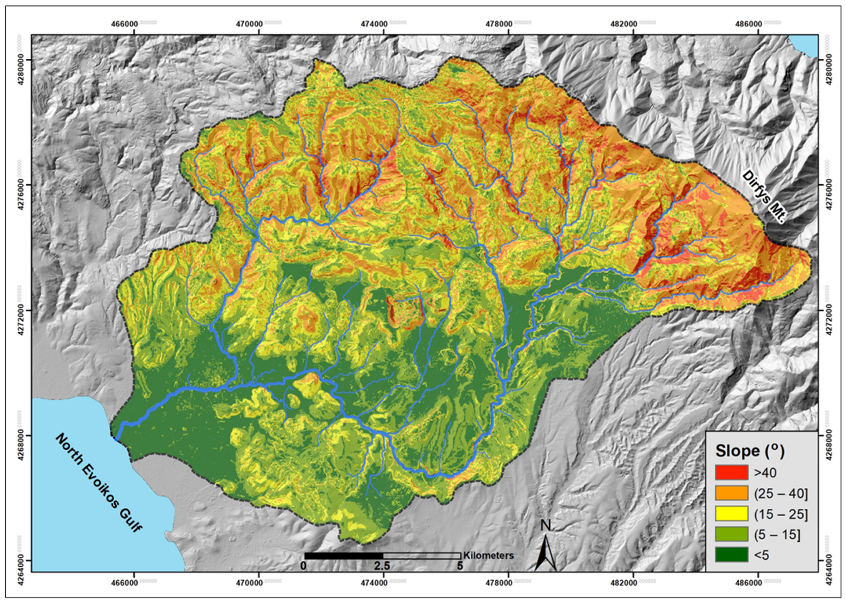
The slope in the study area ranges from 0° to 76°. Approximately 110 km2, or 51% of the total catchment area, fall into the categories of high and very high susceptibility to flood hazard. These gentle sloping areas are predominantly located in the central, southern, and western parts of the catchment, primarily covering the plains of Psachna and Triada. Conversely, the steeply sloping areas of low and very low flood risk are found in the northern and eastern parts of the study area, corresponding to the mountainous regions of Mount Dirfys.
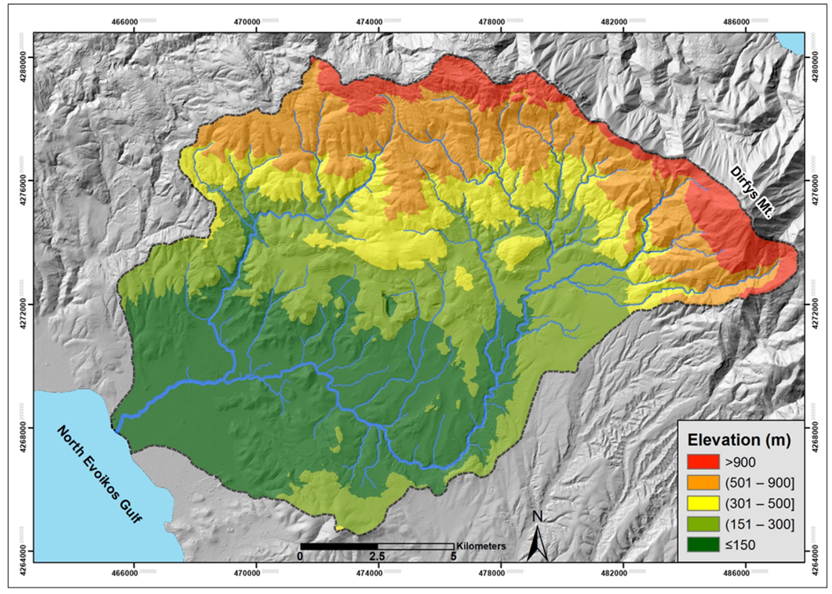
The Messapios River catchment is predominantly characterized as a lowland region, with its highest elevation reaching 1717 m along its eastern border, at the western slopes of Mount Dirfys. Approximately 65% of the catchment area (~137 km2) lies below 300 m in elevation, where most settlements are concentrated. Notably, all documented flood events have occurred within this zone, which is classified as highly to very highly susceptible to flooding. Areas exceeding 900 m in elevation are confined to the northern and northeastern mountainous parts of the catchment, accounting for only a small fraction (~4%) of the total area.
Based on the classification used for the “distance from the stream channels” criterion, areas adjacent to the stream channel beds of higher Strahler-order steams in the drainage network are categorized as highly to very highly flood-prone. These flood-susceptible zones are primarily situated along the main stream channels of Messapios and its major 5th order tributaries (Figure 5).
According to the “land cover” criterion, approximately 60% of the study area (~130 km2), primarily located in the northern, eastern, and central-southern parts of the catchment, is covered by forests and semi-natural vegetation with very low susceptibility to flooding. A notable part (~40 km2 representing ~18% of the total catchment) consists of agricultural and cultivable land with low flood susceptibility, while artificial surfaces highly susceptible to flooding (~5 km2) correspond to settlement and account for only a small percentage (~3.5%) of the study area. However, ~19% (~41 km2) of the catchment, located in the central and western parts, hosts non-irrigated arable land and areas with sparse vegetation, which are classified as highly susceptible to flooding during heavy precipitation events.
A substantial part of the catchment area, approximately 103 km2 (~48% of the total), is covered by permeable carbonate geological formations, which are considered to have low susceptibility to flooding. In addition, about 50 km2 (~23% of the catchment), primarily in the lower reaches of the Messapios River (the plains of Psachna and Triada) and along the main channels of the drainage network, is occupied by very highly permeable alluvial deposits with very low susceptibility to flooding.

4.2. Flood-Hazard Assessment

All five criteria used to assess the flood hazard of the study area have been reclassified into a unified scale, allowing for their integration into a single thematic layer. To achieve this, the Weighted Linear Combination (WLC) method was applied. The criteria were multiplied by the weights derived from the AHP method, and the resulting products were summed. The pairwise comparisons matrix and the outcomes of the AHP process—including the determination of criteria weights and the calculation of the CR—are presented in Table 5, Table 6 and Table 7, respectively.
The calculated weights indicate that Slope (39.5%) and Elevation (23.9%) are the most influential factors in the flood-hazard assessment of this study, while geological formations (7.3%) are the least significant. The CR value is 0.0296 (Table 7), which is lower than the threshold of 0.1, indicating acceptable consistency in the hierarchy and pairwise comparison of the criteria. Therefore, the consistency of the resulting weights is confirmed, and the flood-hazard assessment can proceed.

4.3. Sensitivity Analysis

Sensitivity Analysis is performed to determine whether the forecast model is vulnerable to micro-variations in the weighting factors of the criteria examined. For the sensitivity analysis, a small variation of the coefficient of the strongest factor will be performed with a simultaneous small variation of the coefficient of the second-strongest factor [58]. The variation should not be large because there is a risk of negatively affecting the effectiveness of the model chosen.
For the sensitivity analysis, two scenarios were considered. In the first scenario, the weight of the strongest criterion (Slope) was increased by 0.05, while simultaneously the weight of the second-strongest criterion (Elevation) was decreased by 0.05. In the second scenario, the opposite adjustment was applied. Table 8 presents the sensitivity analysis scenarios.
The criteria were then integrated as before, using the Weighted Linear Combination (WLC) method but with the updated weights for the two scenarios. This process produced two new thematic maps representing the flood hazard of the catchment area for each scenario.
Table 9 and Table 10 show that the deviations of the two scenarios considered in the sensitivity analysis, compared to the flood risk estimated using the AHP model, are minimal. Specifically, in Scenario 1, the maximum negative percentage deviation (−1.57%) appears in category (1)—very low flood risk, while the maximum positive percentage deviation (+1.71%) occurs in category (2)—low flood risk. In Scenario 2, the maximum negative percentage deviation (−0.58%) occurs in category (3)—moderate flood risk, while the maximum positive percentage deviation (+0.73%) appears in category (2)—low flood risk. These deviations are minor, indicating that the selected model was not greatly influenced by small changes in the weights, and thus can be considered stable.

4.4. Verification of the Flood-Hazard Assessment

The results of this study were compared with the thematic layer of flood-prone zones provided by the Special Secretariat for Water of the Ministry of Environment and Energy of Greece. Additionally, a layer depicting locations within the Messapios River catchment affected by historical flood events was compared to the flood-hazard map produced using the AHP method. These comparisons enabled the verification of whether the areas classified as very high flood-hazard level zones aligned with these additional data layers.
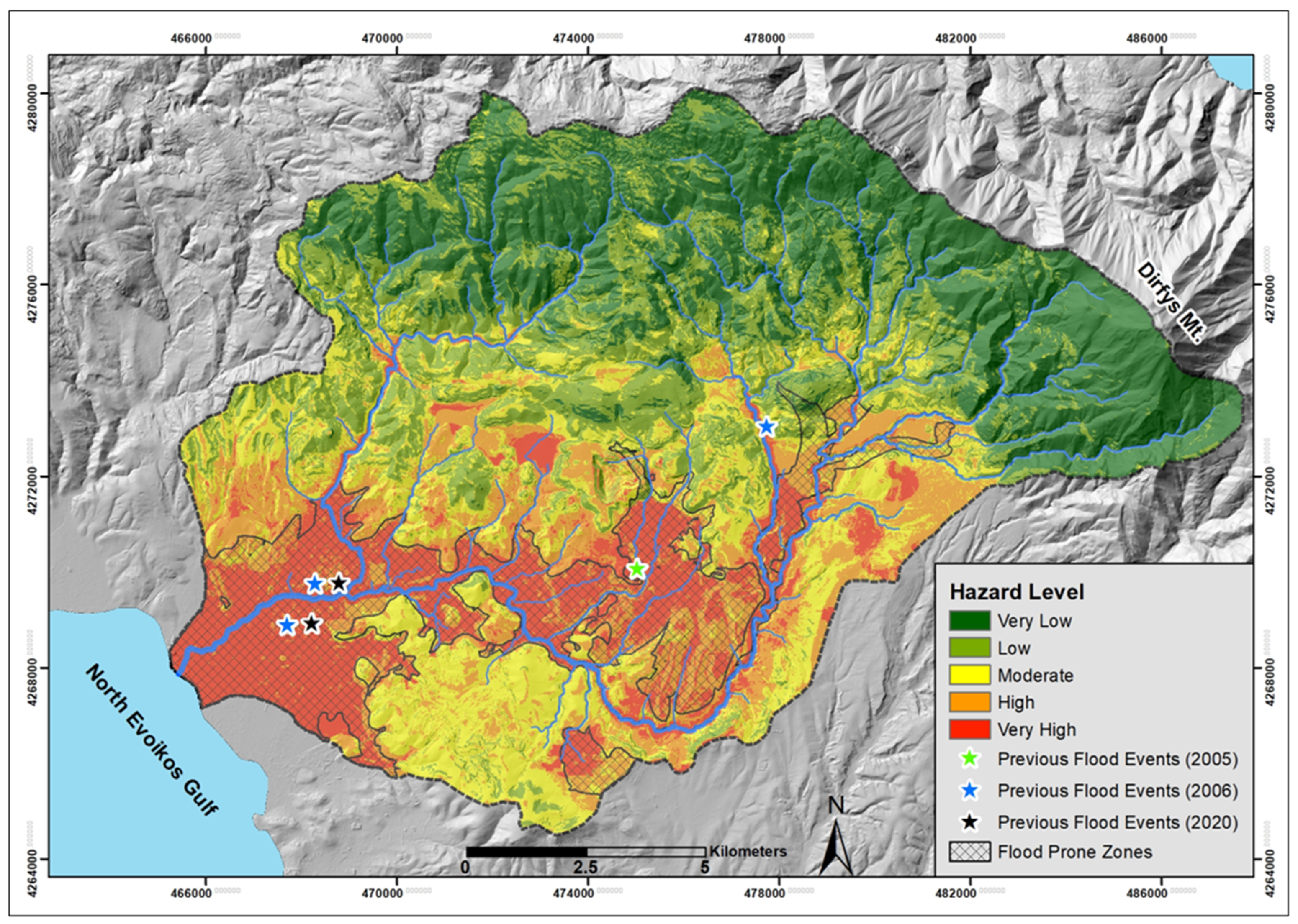
Figure 8 illustrates an overlay between the flood-prone zone layer as estimated by the Special Secretariat of Water of the Ministry of Environment and Energy of Greece, and the flood-hazard level layer calculated in this study by using the AHP method. The comparison between these two layers demonstrates a strong correlation between the results of both methodologies, as 78% of the area classified in this study as having very high flood-hazard level aligns with the flood-prone zone as assessed by the Special Secretariat. Similarly, when analyzing the flood-prone zone designated by the Special Secretariat, approximately 85% of the area identified as flood-prone by the Special Secretariat aligns with zones classified as very high flood-hazard level in this study.
However, when comparing the flood events of 2005, 2006, and 2020, all of which occurred within the zones classified as very high flood-hazard areas in this study, an important observation is that the 2020 event lies outside the flood-prone zone proposed by the Special Secretariat. This indicates that, despite the 2020 event occurring in an upstream part of the catchment, the area’s morphology favors the occurrence of flood events, even within minor basins. The discrepancy in the 2020 event underscores the limitations of the current zoning approach, emphasizing the need for a stronger consideration of geomorphological factors to improve the accuracy of flood-hazard assessments. In this context, the study classifies areas with similar characteristics as high or very high flood-hazard zones in the central part of the catchment, where low slopes appear to play a crucial role in driving flood events. These findings suggest that the applied methodology not only aligns well with past flood events but also enhances existing flood-hazard delineations by identifying additional areas with high or very high flood-hazard levels.
Based on all the above, it can be concluded that the selected model applied for the flood-hazard assessment of the Messapios River catchment is quite reliable and provides a more refined and comprehensive flood-hazard assessment, contributing to the prevention and management of flood risk in this area.

4.5. Spatial Distribution of Flood-Hazard Zones

The areas corresponding to each of the five flood-hazard zones, as depicted in the flood-hazard assessment maps shown in Figure 8 and Figure 9, are provided in Table 10. The “very high” and “high” flood-hazard zones cover approximately one-third of the study area. Specifically, an area of 38.58 km2, representing 17.86% of the total catchment, is classified as very highly prone to flooding, while 38.91 km
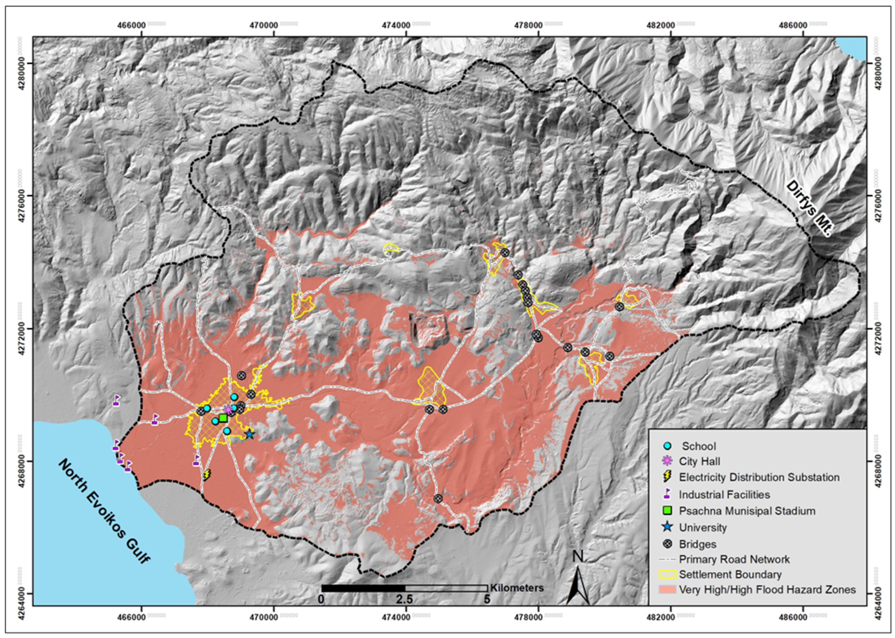
2 (18.02% of the catchment) falls within the high flood-hazard zone. These zones are primarily located in the central, southern, and western parts of the study area, mainly at the lower reaches of the catchment, on both sides of the channels of the main streams (Messapios, Mantanias, Makrimalli, Koumpes) and in the gently sloping, low-lying fan delta of the river. Conversely, the “very low” and “low” flood-hazard areas occupy the northern and easternmost parts of the catchment, corresponding to predominantly mountainous regions with steep slopes and dense vegetation. The comparison of the spatial distribution of settlements and critical infrastructure—such as the road network, bridges, schools, industrial facilities, and electricity distribution substations—with the flood-hazard zones mapped in this study (Figure 10) provides a preliminary assessment of the area’s vulnerability to flood hazard.
All settlements in the study area, except for the village of Platana, are located in highly and very highly prone to flooding areas. This is because residential areas are built on gently sloping areas, at relatively low elevations, and in close proximity to the main stream channels of the drainage network. Thus, approximately 9000 residents are exposed to flood hazard as they live in settlements with very high flood susceptibility. The settlements of Psachna and Makrykapa are considered to be at higher risk because the Messapios River and Makrikapiatiko River flow through these settlements, respectively, and they have previously been affected by severe flood events. The settlement of Makrykapa experiences relatively frequent, small-scale flooding events, such as during the extreme weather event “Elias” on 27 September 2023.
A significant length of the road network in the study area, amounting to approximately 60 km, is located in high and very high flood-hazard level areas. Furthermore, all the bridges of the road network are located in areas of very high flood risk, as they cross over riverbeds where the channels are insufficient to accommodate extreme flash flood discharges.
The five largest industrial facilities in the study area, which employ hundreds of workers, are located in the low-lying, low-elevation, very highly prone to flooding zone of the Messapios River fan delta, with two of them situated just a few dozen meters from the river mouth. Within the very high flood-risk zone is the General High School of Psachna, which is built just a few meters from the banks of the Messapios River. It is noteworthy that many students from across the Municipality of Dirfys-Messapia attend this school. Adjacent to the school is the Psachna Municipal Stadium, a place frequently visited by many people. The university campus, located on the outskirts of the town and also within the very high flood-hazard zone, accommodates hundreds of students who attend courses there on a daily basis, significantly heightening the exposure to floods. Of particular importance is that the Public Power Corporation substation is also located within the very high flood-hazard zone.
Finally, almost the entire area of the Psachna and Triada plains, which are the main sources of agricultural production in the study area, lies within the very high flood-risk zone. Therefore, the impact of a potential flood would be devastating for the local economy of the region.
The flood-hazard assessment map is a valuable tool for regional land-use planning, enabling the identification of areas suitable or unsuitable for urban development [59,60]. While hazard maps reflect the current state of flood risk across the catchment, they offer invaluable insights that can guide long-term policymaking and future planning. This is especially critical for the study area, where land cover is continuously changing, primarily due to the devastating impact of wildfires that have ravaged a significant part of the catchment’s forests.
A significant factor in the severity of floods is the quantity of transported materials [61]. These materials consist of soil fine-grained particles, rocky debris and boulders, or other elements (tree trunks, trash, cars, and materials from destroyed structures such as buildings and bridges) with varying particle-size composition [62]. They are transported and contained in the floodwaters, and as a solid–liquid mixture contributes to the damage. This parameter (as a quantity measurement) is usually not recorded, resulting in an underestimation of the actual floodwaters and the maximum “flood depth”. Geomorphological mapping, as a future work, could significantly enhance flood-hazard zonation by offering a more precise representation of erosional and depositional processes, including the potential existence of alluvial fans in streams confluence and the debris flows as flash flood indicators. Detailed mapping of these processes would improve the assessment of flood magnitude and extent in a more deterministic manner, allowing for better prediction of flood dynamics and identification of areas with varying proneness to flooding, whether higher or lower.
One cause of increased sediment load and flood runoff in the study area is soil erosion in areas affected by wildfires [63]. The major wildfires in Evia that occurred in 2018 and 2019 impacted the wider Psachna area. The 2018 wildfire burned approximately 48.5 km2, with the affected areas located west of the Messapios River catchment and only a small portion within it. In contrast, the August 2019 wildfire occurred entirely within the study area, with an estimated burned area of approximately 97 km2. This area constituted the upper part of the catchment of the Mantania Stream, a tributary that joins the Messapios River just upstream from Psachna. This wildfire, due to its impact on increasing transported material, was identified as one of the main factors contributing to the severity of the flood that affected the Psachna area in August 2020 [64,65].

5. Conclusions

In this study, MCDA employing the AHP method provided an effective, structured, and comprehensive approach to assess flood hazard in the Messapios River catchment by integrating various factors, including topography (slope, elevation, and proximity to stream channels), land cover, and the hydrolithological characteristics of geological formations. The assessment revealed that approximately one-third of the study area is classified within the “high” and “very high” flood-hazard zones, which are primarily located in the central, southern, and western parts, particularly at the lower reaches of the catchment and along the main stream channels. In contrast, the northern and eastern parts, dominated by mountainous regions, fall within the “low” and “very low” flood-hazard zones. A comparison of these hazard zones with the distribution of settlements and critical infrastructure revealed significant vulnerability, as most settlements, including Psachna, Triada, Kastella, and Makrykapa, are located in flood-prone areas. This is particularly concerning for approximately 9000 residents, several industrial facilities, the Psachna General High School, and the local Public Power Corporation substation, all situated in zones highly susceptible to flooding. Additionally, key agricultural areas, such as the Psachna and Triada plains, lie within the very highly prone to floods zone, rendering them highly vulnerable to the impacts of potential flooding. These findings emphasize the urgent need for targeted flood mitigation measures and strategic land-use planning to reduce flood risk and protect both human lives and economic resources in the region.
By simultaneously evaluating multiple criteria, the MCDA method enhances decision-making, offering a balanced and objective framework that supports efficient land-use planning and tailored flood-risk mitigation strategies. This comprehensive approach enables decision-makers to prioritize vulnerable areas, allocate resources efficiently, and implement targeted flood management strategies.

Author Contributions

Conceptualization, E.K.; methodology, V.M., K.T., N.G., D.-V.B., A.S., I.T., K.V. and E.K.; software, V.M., K.T., D.-V.B., A.S. and K.V.; validation, V.M., K.T., N.G., D.-V.B., K.V. and E.K.; formal analysis, V.M., D.-V.B. and E.K.; field survey, V.M., K.T., N.G., D.-V.B., A.S., I.T., K.V. and E.K; resources, E.K.; writing—original draft preparation, V.M. and E.K.; writing—review and editing, V.M., K.T., D.-V.B., A.S., I.T., K.V. and E.K.; visualization, V.M., D.-V.B. and E.K.; supervision, E.K. All authors have read and agreed to the published version of the manuscript.

Funding

This research received no external funding.

Data Availability Statement

Publicly available datasets were analyzed in this study: Copernicus CORINE Land Cover (https://land.copernicus.eu/pan-european/corine-land-cover/clc2018; accessed on 10 December 2024). The data presented in this study are available on request from the corresponding author.

Acknowledgments

The authors thank the anonymous reviewers for their valuable recommendations which significantly improved the paper.

Conflicts of Interest

The authors declare no conflicts of interest.

References

  1. Karymbalis, E.; Andreou, M.; Batzakis, D.-V.; Tsanakas, K.; Karalis, S. Integration of GIS-Based Multicriteria Decision Analysis and Analytic Hierarchy Process for Flood-Hazard Assessment in the Megalo Rema River Catchment (East Attica, Greece). Sustainability 2021, 13, 10232. [Google Scholar] [CrossRef]
  2. Centre for Research on the Epidemiology of Disasters (CRED). Disasters in Numbers. 2023. Available online: https://files.emdat.be/reports/2023_EMDAT_report.pdf (accessed on 10 December 2024).
  3. Turconi, L.; Bono, B.; Faccini, F.; Luino, F. Anthropic Constraint Dynamics in European Western Mediterranean Floodplains Related to Floods Events. Remote Sens. 2023, 15, 4798. [Google Scholar] [CrossRef]
  4. Lionello, P.; Scarascia, L. The relation of climate extremes with global warming in the Mediterranean region and its north versus south contrast. Reg. Environ. Change 2020, 20, 31. [Google Scholar] [CrossRef]
  5. Valente, M.; Del Prete, C.; Facci, G.; Martino, A.; Grilli, G.R.; Bravi, F.; Reno, C.; Ragazzoni, L. The 2023 floods in the Emilia-Romagna Region, Italy: A retrospective qualitative investigation into response strategies and criticalities. Int. J. Disaster Risk Reduct. 2024, 116, 105089. [Google Scholar] [CrossRef]
  6. Cremonini, L.; Randi, P.; Fazzini, M.; Nardino, M.; Rossi, F.; Georgiadis, T. Causes and Impacts of Flood Events in Emilia-Romagna (Italy) in May 2023. Land 2024, 13, 1800. [Google Scholar] [CrossRef]
  7. Di Giustino, G.; Bonora, A.; Federico, K.; Reho, M.; Lucertini, G. Spatial Analysis of the Vulnerability to Flooding in the Rural Context: The Case of the Emilia Romagna Region. Atmosphere 2022, 13, 1181. [Google Scholar] [CrossRef]
  8. Diakakis, M.; Katsetsiadou, K.; Palikarakis, A. Flood fatalities in Athens, Greece 1880–2010. Bull. Geol. Soc. Greece 2013, 47, 1407–1416. [Google Scholar] [CrossRef]
  9. Diakakis, M.; Papagiannaki, K.; Fouskaris, M. The Occurrence of Catastrophic Multiple-Fatality Flash Floods in the Eastern Mediterranean Region. Water 2022, 15, 119. [Google Scholar] [CrossRef]
  10. Saaty, T.L. (a) An exposition of the AHP in reply to the paper remarks on the analytic hierarchy process. Manag. Sci. 1990, 36, 259–268. [Google Scholar] [CrossRef]
  11. Saaty, T.L. (b) How to make a decision: The analytic hierarchy process. Eur. J. Oper. Res. 1990, 48, 9–26. [Google Scholar] [CrossRef]
  12. Ayalew, L.; Yamagishi, H.; Ugawa, N. Landslide susceptibility mapping using GIS-based weighted linear combination, the case in Tsugawa area of Agano River, Niigata Prefecture, Japan. Landslides 2004, 1, 73–81. [Google Scholar] [CrossRef]
  13. Rozos, D.; Bathrellos, G.D.; Skilodimou, H.D. Comparison of the implementation of Rock Engineering System (RES) and Analytic Hierarchy Process (AHP) methods, based on landslide susceptibility maps, compiled in GIS environment. A case study from the Eastern Achaia County of Peloponnesus, Greece. Environ. Earth Sci. 2011, 63, 49–63. [Google Scholar] [CrossRef]
  14. Argyriou, A.V.; Teeuw, R.M.; Rust, D.; Sarris, A. GIS multi-criteria decision analysis for assessment and mapping of neotectonic landscape deformation: A case study from Crete. Geomorphology 2016, 253, 262–274. [Google Scholar] [CrossRef]
  15. Valkanou, K.; Karymbalis, E.; Papanastassiou, D.; Soldati, M.; Chalkias, C.; Gaki-Papanastassiou, K. Assessment of Neotectonic Landscape Deformation in Evia Island, Greece, Using GIS-Based Multi-Criteria Analysis. ISPRS Int. J. Geo-Inf. 2021, 10, 118. [Google Scholar] [CrossRef]
  16. Arabameri, A.; Pradhan, B.; Pourghasemi, H.R.; Rezaei, K. Identification of erosion-prone areas using different multi-criteria decision-making techniques and GIS. Geomat. Nat. Hazards Risk 2018, 9, 1129–1155. [Google Scholar] [CrossRef]
  17. Patel, A.; Ramana Rao, K.V.; Rajwade, Y.A.; Saxena, C.K.; Singh, K.; Srivastava, A. Comparative Analysis of MCDA Techniques for Identifying Erosion-Prone Areas in the Burhanpur Watershed in Central India for the Purposes of Sustainable Watershed Management. Water 2022, 15, 3891. [Google Scholar] [CrossRef]
  18. Kazakis, N.; Kougias, I.; Patsialis, T. Assessment of flood hazard areas at a regional scale using an index-based approach and Analytical Hierarchy Process: Application in Rhodope-Evros region, Greece. Sci. Total Environ. 2015, 538, 555–563. [Google Scholar] [CrossRef]
  19. Elsheikh, R.F.A.; Ouerghi, S.; Elhag, A.R. Flood Risk Map Based on GIS, and Multi Criteria Techniques (Case Study Terengganu Malaysia). J. Geogr. Inf. Syst. 2015, 7, 348–357. [Google Scholar] [CrossRef]
  20. Das, S. Flood susceptibility mapping of the Western Ghat coastal belt using multi-source geospatial data and analytical hierarchy process (AHP). Remote. Sens. Appl. Soc. Environ. 2020, 20, 100379. [Google Scholar] [CrossRef]
  21. Ouma, Y.O.; Tateishi, R. Urban flood vulnerability and risk mapping using integrated multi-parametric AHP and GIS: Methodological overview and case study assessment. Water 2014, 6, 1515–1545. [Google Scholar] [CrossRef]
  22. Gigovic, L.; Pamučar, D.; Bajić, Z.; Drobnjak, S. Application of GIS-Interval Rough AHP Methodology for Flood Hazard Mapping in Urban Areas. Water J. 2017, 9, 360. [Google Scholar] [CrossRef]
  23. Das, S. Geographic information system and AHP-based flood hazard zonation of Vaitarna basin, Maharashtra, India. Arab. J. Geosci. 2018, 11, 576. [Google Scholar] [CrossRef]
  24. Radwan, F.; Alazba, A.A.; Mossad, A. Flood risk assessment and mapping using AHP in arid and semiarid regions. Acta Geophys. 2019, 67, 215–229. [Google Scholar] [CrossRef]
  25. Nardi, F.; Annis, A.; Di Baldassarre, G.; Vivoni, E.R.; Grimaldi, S. GFPLAIN250m, a global high-resolution dataset of Earth’s floodplains. Sci. Data. 2019, 6, 180309. [Google Scholar] [CrossRef]
  26. Pavesi, L.; D’Angelo, C.; Volpi, E.; Fiori, A. RESCUE: A geomorphology-based, hydrologic-hydraulic model for large-scale inundation mapping. J. Flood Risk Manag. 2022, 15, e12841. [Google Scholar] [CrossRef]
  27. Samela, C.; Albano, R.; Sole, A.; Manfreda, S. A GIS tool for cost-effective delineation of flood-prone areas. Comput. Environ. Urban. Syst. 2018, 70, 43–52. [Google Scholar] [CrossRef]
  28. Bathrellos, G.; Karymbalis, E.; Skilodimou, H.; Gaki-Papanastassiou, K.; Baltas, E. Urban flood hazard assessment in the basin of Athens Metropolitan city, Greece. Environ. Earth Sci. 2016, 75, 319. [Google Scholar] [CrossRef]
  29. Tsanakas, K.; Gaki-Papanastassiou, K.; Kalogeropoulos, K.; Chalkias, C.; Katsafados, P.; Karymbalis, E. Investigation of flash flood natural causes of Xirolaki Torrent, Northern Greece based on GIS modeling and geomorphological analysis. Nat. Hazards 2016, 84, 1015–1033. [Google Scholar] [CrossRef]
  30. Feloni, E.; Mousadis, I.; Baltas, E. Flood vulnerability assessment using a GIS-based multi-criteria approach–The case of Attica region. J. Flood Risk Manag. 2020, 13, e12563. [Google Scholar] [CrossRef]
  31. Stefanidis, S.; Stathis, D. Assessment of flood hazard based on natural and anthropogenic factors using analytic hierarchy process (AHP). Nat. Hazards 2013, 68, 569–585. [Google Scholar] [CrossRef]
  32. Papaioannou, G.; Vasiliades, L.; Loukas, A. Multi-criteria analysis framework for potential flood prone areas mapping. Water Resour. Manag. 2015, 29, 399–418. [Google Scholar] [CrossRef]
  33. Bathrellos, G.D.; Skilodimou, H.D.; Chousianitis, K.; Youssef, A.M.; Pradhan, B. Suitability estimation for urban development using multi-hazard assessment map. Sci. Total Environ. 2017, 575, 119–134. [Google Scholar] [CrossRef]
  34. Skilodimou, H.D.; Bathrellos, G.D.; Chousianitis, K.; Youssef, A.M.; Pradhan, B. Multi-hazard assessment modeling via multicriteria analysis and GIS: A case study. Environ. Earth Sci. 2019, 78, 47. [Google Scholar] [CrossRef]
  35. Skilodimou, H.; Bathrellos, G.; Pappa, M.-I.; Youssef, A.; Kontakiotis, G.; Karymbalis, E. Assessing flood hazard mapping using AHP and GIS in a tectonically active region. Z. Fur Geomorphol. 2025; forthcoming. [Google Scholar] [CrossRef]
  36. Skilodimou, H.D.; Bathrellos, G.D.; Alexakis, D.E. Flood Hazard Assessment Mapping in Burned and Urban Areas. Sustainability 2021, 13, 4455. [Google Scholar] [CrossRef]
  37. IGME. Geological Map of Greece, Scale 1:50.000. Psachna and Steni, Sheets; Institute of Geology and Mineral Exploration: Athens, Greece, 1981. [Google Scholar]
  38. Katsafados, P.; Kalogirou, S.; Papadopoulos, A.; Korres, G. Mapping long-term atmospheric variables over Greece. J. Maps 2012, 8, 181–184. [Google Scholar] [CrossRef]
  39. Special Secretariat of Water, Ministry of Environment and Energy, Greece. Flood Risk Management Plan for the East Sterea Hellas River Basins, Stage I, 1st Phase—Deliverable 1, Analysis of the Areas’ Features and Flood Mechanisms; The Hellenic Government: Athens, Greece, 2017; p. 46.
  40. Hellenic Statistical Authority (ELSTAT), Population Census. 2021. Available online: https://www.statistics.gr/en/2021-census-res-pop-results (accessed on 10 December 2024).
  41. Haan, C.T.; Barfield, B.J.; Hayes, J.C. Design Hydrology and Sedimentology for Small Catchments; Elsevier: San Diego, CA, USA, 1994; p. 608. [Google Scholar]
  42. Patrikaki, O.; Kazakis, N.; Kougias, I.; Patsialis, T.; Theodossiou, N.; Voudouris, K. Assessing Flood Hazard at River Basin Scale with an Index-Based Approach: The Case of Mouriki, Greece. Geosciences 2018, 8, 50. [Google Scholar] [CrossRef]
  43. Grimm, M.M.; Wohl, E.E.; Jarrett, R.D. Coarse-sediment distribution as evidence of an elevation limit for flash flooding, Bear Creek, Colorado. Geomorphology 1995, 3, 199–210. [Google Scholar] [CrossRef]
  44. Mojaddadi, H.; Pradhan, B.; Nampak, H.; Ahmad, N.; Ghazali, A.H.B. Ensemble machine learning-based geospatial approach for flood risk assessment using multisensor remote-sensing data and GIS. Geomatics Nat. Hazards Risk 2017, 8, 1080–1102. [Google Scholar] [CrossRef]
  45. Souissi, D.; Zouhri, L.; Hammami, S.; Msaddek, M.H.; Zghibi, A.; Dlala, M. GIS-based MCDM–AHP modeling for flood susceptibility mapping of arid areas, southeastern Tunisia. Geocarto Int. 2020, 35, 991–1017. [Google Scholar] [CrossRef]
  46. Das, S. Geospatial mapping of flood susceptibility and hydro-geomorphic response to the floods in Ulhas basin, India. Rem. Sens. Appl. Soc. Environ. 2019, 14, 60–74. [Google Scholar] [CrossRef]
  47. Predick, K.I.; Turner, M.G. Landscape configuration and flood frequency influence invasive shrubs in floodplain forests of the Wisconsin River (USA). J. Ecol. 2008, 96, 91–102. [Google Scholar] [CrossRef]
  48. Pham, B.T.; Avand, M.; Janizadeh, S.; Phong, T.V.; Al-Ansari, N.; Ho, L.S.; Das, S.; Le, H.V.; Amini, A.; Bozchaloei, S.K.; et al. GIS based hybrid computational approaches for flash flood susceptibility assessment. Water 2020, 12, 683. [Google Scholar] [CrossRef]
  49. Strahler, A.N. Quantitative analysis of watershed geomorphology. Eos Trans. Am. Geophys. Union. 1957, 38, 913–920. [Google Scholar] [CrossRef]
  50. Komolafe, A.A.; Herath, S.; Avtar, R. Methodology to assess potential flood damages in urban areas under the influence of climate change. Nat. Hazards Rev. 2018, 19, 05018001. [Google Scholar] [CrossRef]
  51. Voutsis, N.; Kelepertzis, E.; Tziritis, E.; Kelepertzis, A. Assessing the hydrogeochemistry of groundwaters in ophiolite areas of Euboea Island, Greece, using multivariate statistical methods. J. Geochem. Explor. 2015, 159, 79–92. [Google Scholar] [CrossRef]
  52. Saaty, T.L. A scaling method for priorities in hierarchical structures. J. Math. Psychol. 1977, 15, 234–281. [Google Scholar] [CrossRef]
  53. Saaty, T.L. Decision making—The analytic hierarchy and network processes (AHP/ANP). J. Syst. Sci. Syst. Eng. 2004, 13, 1–35. [Google Scholar] [CrossRef]
  54. Samal, D.R.; Gedam, S.S.; Nagarajan, R. GIS based drainage morphometry and its influence on hydrology in parts of Western Ghats region, Maharashtra, India. Geocarto Int. 2015, 30, 755–778. [Google Scholar] [CrossRef]
  55. Mu, E.; Pereyra-Rojas, M. Practical Decision Making: An Introduction to the Analytic Hierarchy Process (AHP) Using Super Decisions V2; Springer: Cham, Switzerland, 2016; p. 111. [Google Scholar]
  56. Saaty, R.W. The analytic hierarchy process—What it is and how it is used. Math. Model. 1987, 9, 161–176. [Google Scholar] [CrossRef]
  57. Malczewski, J. GIS and Multicriteria Decision Analysis; John Wiley & Sons, Inc.: New York, NY, USA, 1999. [Google Scholar]
  58. Saaty, T.L.; Vargas, L.G. Decision Making with the Analytic Network Process; Springer Science+ Business Media, LLC.: Berlin, Germany, 2006; Volume 282. [Google Scholar] [CrossRef]
  59. Nunes Correia, F.; Da Graca Saraiva, M.; Nunes Da Silva, F.; Ramos, I. Floodplain management in urban developing areas Part I Urban growth scenarios and land-use controls. Water Res. Manag. 1999, 13, 1–21. [Google Scholar] [CrossRef]
  60. Ologunorisa, T.E.; Abawua, M.J. Flood risk assessment: A review. J. Appl. Sci. Environ. Manag. 2005, 9, 57–63. [Google Scholar]
  61. Karalis, S.; Karymbalis, E.; Mamassis, N. Models foe sediment yield in mountainous Greek catchments. Geomorphology 2018, 322, 76–88. [Google Scholar] [CrossRef]
  62. Karymbalis, E.; Katsafados, P.; Chalkias, C.; Gaki-Papanastassiou, K. An integrated study for the evaluation of natural and anthropogenic causes of flooding in small catchments based on geomorphological and meteorological data and modeling techniques: The case of the Xerias torrent (Corinth, Greece). Z. Fur Geomorphol. 2012, 56, 45–67. [Google Scholar] [CrossRef]
  63. Valkanou, K.; Karymbalis, E.; Bathrellos, G.; Skilodimou, H.; Tsanakas, K.; Papanastassiou, D.; Gaki-Papanastassiou, K. Soil loss potential assessment for natural and post-fire conditions in Evia Island, Greece. Geosciences 2022, 12, 367. [Google Scholar] [CrossRef]
  64. Lekkas, E.; Spyrou, N.I.; Kotsi, E.; Filis, C.; Diakakis, M.; Cartalis, C.; Vassilakis, E.; Mavrakou, T.; Sartabakos, P.; Gogou, M.; et al. The August 9, 2020, Evia (Central Greece) Flood. Newsl. Environ. Disaster Cris. Manag. Strateg. 2020, 19, 1–68. [Google Scholar]
  65. Kapralos, H.; Apostolidis, H. Report on the Flood of August 9, 2020. In Central Evia (Politika, Psachna, Lilandio Plain); “Yli Environmental Management and Protection” Company: Athens, Greece, 2021. [Google Scholar]
Figure 1. Hillshaded map of the Messapios drainage network and catchment. The inset provides the geographical context of the study area.
Land 14 00658 g001
Figure 2. Flow chart of the methodological framework followed in this study.
Land 14 00658 g002
Figure 3. Thematic map of the Messapios River catchment depicting the classification of slope values into five categories. Each slope class has been assigned a rating based on the outlined methodology, as detailed in Table 4.
Land 14 00658 g003
Figure 4. Thematic map of the Messapios River catchment depicting the classification of elevation values into five categories. Each elevation class has been assigned a rating based on the outlined methodology, as detailed in Table 4.
Land 14 00658 g004
Figure 5. Thematic maps showing the spatial distribution of the “distance from stream channels” criterion for 3rd order (a), 4th order (b), 5th order (c), and 6th order (d) streams. The Distances categories were classified into five groups, as shown in Table 4.
Land 14 00658 g005aLand 14 00658 g005b
Figure 6. Thematic map illustrating the spatial distribution of land cover classes classified according to the five-tier scale defined in Table 4.
Land 14 00658 g006
Figure 7. Thematic map showing the spatial distribution of the five geological formation classes, categorized according to the grading system defined in Table 4.
Land 14 00658 g007
Figure 8. Flood-hazard map of the Messapios River catchment. The flood-prone zones as provided by the Special Secretariat of Water of the Ministry of Environment and Energy of Greece, along with the locations of previous flood events, are also depicted.
Land 14 00658 g008
Figure 9. Maps showing the flood-hazard level distribution results based on sensitivity analysis for Scenario 1 (a) and Scenario 2 (b).
Land 14 00658 g009
Figure 10. Comparison of the flood-hazard zones in the Messapios River catchment, as mapped in this study, with the spatial distribution of settlements and critical infrastructure, including the primary road network, bridges, schools, industrial facilities, and electricity distribution substations.
Land 14 00658 g010
Table 1. The pairwise comparison matrix of the criteria. Each element aij in the matrix represents the relative importance of factor i compared to factor j. n represents the number of criteria (5 in this study).
a11 = 1a12a1n
a21a22 = 1a2n
an1an2ann = 1
Sum_1Sum_2Sum_n
Table 2. Preference values (aij) are divided by the column sums (Sum_i), followed by the row sums (Row_sumi) to calculate the weights (wi), obtained by dividing each row sum by the total number of criteria (n) [55].
aij/Sum_jRow_SumiWeight (wi)
a11/Sum_1a12/Sum_2a1n/Sum_nRow_sum1Row_sum1/n
a21/Sum_1a22/Sum_2a2n/Sum_nRow_sum2Row_sum2/n
an1/Sum_1an2/Sum_2ann/Sum_nRow_sumnRow_sumn/n
Table 3. Calculation of the Weighted Sum Vector (WVn), where wi represents weight (from Table 2) and aij denotes the preference values (from Table 1).
WV1 = a11w1 + a12w2 + … + a1nwn
WV2 = a21w1 + a22w2 + … + a2nwn
WVn = an1w1 + an2w2 + … + annwn
Table 4. Matrix of assigned rating classes for the selected flood-hazard criteria, including the area occupied by each class for each criterion.
Flood-Hazard CriterionClassRatingArea (km2)Area (%)
>40110.034.65
25–40250.4223.35
Slope (°)15–25345.0120.24
5–15461.0628.27
<5549.4422.89
901–1717114.973.93
501–900239.2918.19
Elevation (m a.m.s.l.)301–500327.9212.93
151–300455.5825.74
<150578.2039.21
>80 for the 3rd order streams, >100 for 4th order streams, >120 for 5th order streams, and >150 for 6th order stream1205.0394.94
60–80 for the 3rd order streams, 80–100 for 4th order streams, 100–120 for 5th order streams, and 130–150 for 6th order stream21.880.87
Distance from stream channels (m)40–60 for the 3rd order streams, 60–80 for 4th order streams, 80–100 for 5th order streams, and 100–130 for 6th order stream32.150.99
20–40 for the 3rd order streams, 30–60 for 4th order streams, 40–80 for 5th order streams, and 50–100 for 6th order stream43.151.46
<20 for the 3rd order streams, <30 for 4th order streams, <40 for 5th order streams, and <50 for 6th order stream53.751.74
Forests (broad-leaved, coniferous, mixed), Sclerophyllous vegetation, Transitional woodland-shrub1129.9060.13
Olive groves, natural grasslands, shrub, and/or herbaceous vegetation associations216.157.47
Land coverComplex cultivation patterns, and principally occupied by agriculture, with significant areas of natural vegetation323.5410.90
Non-irrigated arable land, sparsely vegetated areas441.3819.19
Discontinuous urban fabric, industrial or commercial units54.992.31
Permeable alluvial deposits149.8523.08
Permeable carbonate rocks2103.4447.90
Geological formationsSemi-permeable alternations of conglomerates, marls, clays, sandstones320.919.68
Semi-permeable igneous and metamorphic rocks427.7912.87
Flysch formation513.976.47
Table 5. The pairwise comparisons values were derived from expert judgments based on their extensive experience in fluvial geomorphology and flood-hazard analysis, representing the consensus mode of their suggestions.
CriteriaSlopeElevationDistance from Stream ChannelLand CoverGeological Formations
Slope1.002.003.003.004.00
Elevation0.501.002.002.003.00
Distance from stream channel0.330.501.002.003.00
Land cover0.330.500.501.002.00
Geological Formations0.250.330.330.501.00
Sum2.414.336.838.5013.00
Table 6. Weights (W) calculation.
CriteriaSlopeElevationDistance from Stream ChannelLand CoverGeological FormationsSumWeight (W)
Slope0.4150.4620.4390.3530.3081.9770.395
Elevation0.2070.2310.2930.2350.2311.1970.239
Distance from stream channel0.1370.1160.1460.2350.2310.8650.173
Land cover0.1370.1160.0730.1180.1540.5980.119
Geological Formations0.1040.0770.0480.0590.0770.3650.073
Sum11111 1
Table 7. Calculation of the Consistency Ratio (CR).
CriteriaWeight (W)Weighted Sum Vector (WV)Coherence Vector
(C)
λmaxConsistency Index
(CI)
Random Index (RI)Consistency Ratio (CR)
Slope0.3952.0435.16685.13260.03311.120.0296
Elevation0.2391.2405.1797
Distance from stream channel0.1730.8805.0898
Land cover0.1190.6025.0385
Geological Formations0.0730.3685.0473
Table 8. Criteria weights considered for the two scenarios in the sensitivity analysis.
CriteriaWeights (According to AHP)Weights of 1st ScenarioWeights of 2nd Scenario
Slope0.3950.4450.345
Elevation0.2390.1890.289
Distance from stream channel0.1730.1730.173
Land cover0.1190.1190.119
Geological Formations0.0730.0730.073
Table 9. Area (in km2 and %) of the Messapios River catchment in each flood-hazard level estimated using the Weighted Linear Combination (WLC) method with criteria weights estimated by applying the AHP method, and the slightly varied weights from the two scenarios considered in the sensitivity analysis.
AHPUsing the Weights According to 1st ScenarioUsing the Weights According to 2nd Scenario
Flood-Hazard RankingArea (km2)Area (%)Area (km2)Area (%)Area (km2)Area (%)
Very low47.1421.8343.7220.2647.4121.96
Low44.8520.7748.5522.4846.4421.50
Moderate46.4821.5244.2220.4045.2120.94
High38.9118.0241.9019.4038.3417.75
Very high38.5817.8637.5717.3938.5617.85
Table 10. Percentage deviation of the areas of each flood risk category estimated in the two sensitivity analysis scenarios from the areas estimated using AHP.
Flood-Hazard RankingArea (%)
AHP
1st Scenario2nd Scenario
Very low21.83−1.57+0.13
Low20.77+1.71+0.73
Moderate21.52−1.05−0.58
High18.02+1.38−0.27
Very high17.86−0.47−0.01
Disclaimer/Publisher’s Note: The statements, opinions and data contained in all publications are solely those of the individual author(s) and contributor(s) and not of MDPI and/or the editor(s). MDPI and/or the editor(s) disclaim responsibility for any injury to people or property resulting from any ideas, methods, instructions or products referred to in the content.

