Abstract
The mapping of land use/cover (LULC) types is a crucial tool for natural resource management and monitoring changes in both human and physical environments. Unmanned aerial vehicles (UAVs) provide high-resolution data, enhancing the capability for accurate LULC representation at potentially very high spatial resolutions. In the present study, two widely used supervised classification methods, namely the Maximum Likelihood Classification (MLC) and Mahalanobis Distance Classification (MDC), were applied to analyze image data collected by UAVs from a typical Mediterranean site located in Greece. The study area, characterized by diverse land uses (urban, agricultural, and natural areas), served as an ideal field for comparing the two classification methods. Although both methods produced comparable results, MLC outperformed MDC, with an overall accuracy of 96.58% and a Kappa coefficient of 0.942, compared to MDC for which an overall accuracy of 92.77% and a Kappa coefficient of 0.878 were reported. This study highlights the advantages of using UAVs to produce robust information on the geospatial variability of land use/cover in a given area at very high spatial resolution in a cost-efficient, timely, and on-demand manner. Such information can help in decision- and policy-making for ensuring a more sustainable physical environment. This study’s limitations, including the small and relatively homogeneous study area, are acknowledged. Future research could potentially focus on exploring the use of advanced classification techniques, such as deep learning and more diverse Mediterranean landscapes, which would assist in enhancing the present’s approach applicability.
1. Introduction
The ability to produce accurate maps of LULC is particularly important in an era where climate change and human activities are exerting increasing pressure on ecosystems [1,2,3,4]. In this context, recent advancements in remote sensing (RS) technologies, particularly through unmanned aerial vehicles (UAVs), have significantly enhanced the ability to collect data with exceptional detail and precision [5,6]. Despite the growing use of UAVs in RS, there is limited research focusing on their application in Mediterranean environments characterized by spectral complexity and diverse topographies [4,7]. This study addresses this gap by examining land use classification methods in such environments using high-resolution UAV data. The Mediterranean region presents unique challenges due to its diverse land cover types, including agricultural fields, urban zones, and natural vegetation, which are often characterized by spectral complexity and overlapping signatures. These features require high-resolution and context-specific approaches that UAVs are well suited to provide. However, the limited body of research in Mediterranean settings underlines the importance of targeted studies that utilize UAVs to address these challenges and improve land cover mapping accuracy. The increasing use of UAVs for environmental monitoring and mapping has proven highly beneficial, offering flexibility and the ability to collect high-resolution data at low cost, even in remote and inaccessible areas [8,9,10].
The use of UAVs for high-resolution data offers significant advantages, making them an exceptionally effective tool for applications in areas with complex and diverse land uses. Recent improvements in the spectral capabilities of RS sensors attached to UAV platforms allow for more accurate data analysis and classification, enhancing mapping processes [5,6]. UAVs allow data retrieval at any time, regardless of weather conditions, such as cloud cover, which often affects satellite image acquisition [6]. Moreover, they provide extremely high spatial resolution, even at the centimeter scale, and, when equipped with suitable sensors, can offer high-quality spectral data [11,12,13,14,15]. While satellites provide broad coverage, their resolution is often lower, and their imaging schedules are predetermined. In contrast, UAVs can be deployed immediately to collect data in specific areas of interest, offering greater flexibility [16,17]. Overall, UAVs offer a more flexible and cost-effective solution, providing imagery with spatial resolution reaching centimeter levels, enabling more detailed and accurate analysis [5,18,19]. Studies such as that by [20] have shown that UAV usage is particularly effective in scenarios, where satellite RS faces limitations, such as areas with restricted accessibility or regions experiencing frequent vegetation changes. The research by [1] highlighted the ability of UAVs to deliver data with resolution down to the centimeter level, enabling detailed analysis and fine-scale classification. For example, studies have shown that UAV data with centimeter-level spatial resolution can increase classification accuracy by 15–20% compared to medium-resolution satellite data [21].
The literature confirms that UAV usage can accelerate mapping processes and reduce costs compared to traditional surveying methods (Tang et al., 2021; Santos et al., 2021). The ability to capture data at low altitudes ensures the accuracy and quality of the collected information, making UAVs ideal for detailed recording of natural and anthropogenic features [22,23]. The practicality of updating data regularly makes UAVs an invaluable tool for applications such as precision agriculture, disaster monitoring, and urban area mapping. These advantages, combined with low operational costs and quick deployment capability, set them apart from traditional data collection methods such as satellites [24].
A critical factor in successful mapping LULC using UAV data is the appropriate selection of the classification method. Traditional RS methods for LULC mapping, such as supervised classification based on satellite imagery and manned flights, have been widely used for LULC mapping but come with specific limitations, such as lower spatial resolution and high costs when high spatial resolution is required [13,20,25,26,27]. Researchers suggest using hybrid methods or integrating machine learning (ML) techniques to improve results [28,29]. Supervised classification methods, such as Maximum Likelihood Classification (MLC) and Mahalanobis Distance Classification (MDC), are often used for RS data analysis, providing high accuracy, particularly when spectral signatures are distinct [30,31]. These methods often combine spatial, spectral, and structural information provided by UAV data, improving feature separation between categories [32].
MLC, which is based on statistical probability and assuming a normal distribution of data, is effective in cases where spectral signatures are distinct in homogeneous data [28,33]. Conversely, MDC accounts for dispersion and correlations among spectral signatures, making it suitable for data with overlapping characteristics [19,34]. Ref. [35] emphasizes that MDC excels in complex areas with spectral overlap, such as urban and industrial zones. Comparative studies show that MLC is more effective in areas with low spectral overlap, while MDC excels with data characterized by high spectral diversity and complexity [16,20]. For example, ref. [29] applied MDC in areas with spectral overlap, like urban landscapes, where MLC failed to deliver the expected results, which indicated that the selection of the classification method is critical and should be based on the spectral properties of the study area [28,30].
Recent research highlights the benefits of combining traditional classification methods with ML to improve accuracy in distinguishing categories with similar spectral responses [36]. For example, ref. [37] performed land cover classification based on a calibrated orthomosaic derived from DJI Phantom IV multispectral UAV, showing that the MLC technique (93.56% accuracy) outperformed SAM and MDC in terms of accuracy. Later, He et al. (2023) [38] applied MLC based on UAV data in agricultural areas with distinct spectral signatures, achieving high accuracy with an overall precision exceeding 95%, demonstrating the method’s value in regions with clear differences across land cover categories. In another study, ref. [39], a comparative analysis of ML techniques for LULC classification was conducted, highlighting the superiority of SVM as well as the computational efficiency of MDC, although the latter resulted in a lower classification accuracy, particularly in heterogeneous landscapes. Verifying the performance of the classification methods is crucial, employing standard verification methods as highlighted by [40]. This is particularly important in the case of UAV data, where the high resolution enables the use of small training areas, potentially improving classification accuracy. Yet, to our knowledge, there are few studies available in the literature so far comparing the MLC and MDC classifiers using specifically UAV imagery, particularly so in highly fragmented ecosystems such as those that may be found in the Mediterranean region.
To this end, the present study aims to compare the widely used MLC and MDC approaches in LULC mapping, based on very-high-spatial-resolution imagery collected from UAVs. A typical agricultural Mediterranean site located in Greece is used as a case study.
2. Experimental Set-Up
2.1. Study Area
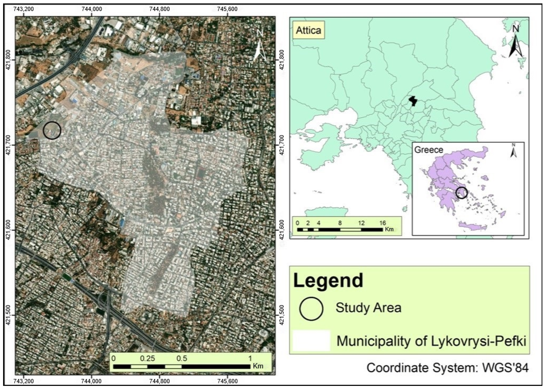
The study area selected for this research is located in Greece, within the region of Attica. Specifically, it is situated in the Municipal Unit of Lykovrysi, which administratively belongs to the Municipality of Lykovrysi–Pefki in the northern metropolitan area of Athens (Figure 1). The broader area of Lykovrysi is characterized by diverse land uses and significant heterogeneity, encompassing urban, semi-urban, agricultural, and natural areas. This diversity makes the region ideal for studying different mapping methods, as the spectral signatures derived from RS images vary significantly [7,41].

Figure 1.
The study area and the Municipality of Lykovrysi–Pefki in relation to Attica/Greece.
The geographical location of Lykovrysi provides easy access to urban and semi-urban zones, while its proximity to natural areas, such as small forested regions and cultivated lands, contributes to the area’s environmental diversity [42]. The area comprises small- and medium-sized fields, gardens, forest zones, and residential areas, adding complexity to land cover mapping [5,20]. The combination of urban development and surrounding natural areas creates a mosaic of landscapes that requires particular attention during land cover classification [24].
Lykovrysi also exhibits geological and morphological peculiarities that influence the spectral response of the Earth’s surface in RS data. The presence of various land cover types, from dense vegetation to low vegetation and bare soil, creates a complex environment for applying supervised classification methods [29,34]. The geographical diversity of the area, including different land uses such as urban, agricultural, and natural areas, creates an ideal setting for evaluating the MLC and MDC methods. This diversity entails significant spectral differentiation as well as varying levels of landscape fragmentation, resulting in categories with both homogeneous and heterogeneous spectral properties [11]. Areas of high spectral homogeneity, such as agricultural zones, provide favorable conditions for classification methods. Conversely, areas with intense fragmentation, such as urban zones or regions with mixed natural and anthropogenic uses, pose challenges for the accuracy and effectiveness of these methods [14]. These conditions allow for testing the resilience of the methods against different levels of spectral diversity and evaluating their ability to deliver accurate classifications in complex environments [43].
The area was also selected for practical accessibility and UAV flight safety, as well as the presence of diverse features that support the validation of classification results through field observations [18]. The topographical conditions, such as relatively flat terrain and the absence of significant altitude variations, make the area suitable for low-altitude flights, ensuring high-quality image data [13].
Finally, the selection of Lykovrysi region provides a unique opportunity for evaluating and comparing classification methods applied to high-resolution data, as the area combines features such as land use heterogeneity, varied spectral signatures, and landscape fragmentation. These characteristics necessitate a differentiated approach to classification as they affect the performance of the MLC and MDC methods. For example, urban areas with high diversity and significant spectral overlap may complicate classification, whereas agricultural zones with more homogeneous spectral properties are easier to manage [31].
2.2. Datasets
The data used in this study were collected using a DJI Phantom 4 Pro UAV equipped with a high-resolution camera (FC6310_8.8_5472x3648 RGB). This device was chosen for its ability to capture high-spatial-resolution images, providing data crucial for the detailed mapping of land cover types [18,19]. The spatial resolution of the images reached 0.96 cm/pixel, ensuring excellent accuracy for detailed analysis and classification of the data [11]. The DJI Phantom 4 Pro, while providing high-resolution imagery, has limitations in its spectral range, which may impact its ability to distinguish certain land cover types. Additionally, its RGB camera is not equipped to capture multispectral or hyperspectral data, which could provide further details in classification.
Data collection was conducted on the morning of 6 May 2022, with the precise flight start time recorded at 08:52:32, under clear weather conditions with minimal cloud cover. The average temperature was 22 °C, with stable lighting conditions ensuring optimal image quality. The UAV was operated on predetermined flight paths, covering an area of 10,356 m2 in the study region and covering a total flight distance of approximately 3.2 km, ensuring sufficient overlap between images. The flight was conducted at an altitude of approximately 70 m above ground level and followed a structured grid pattern to ensure full coverage. The total flight duration was approximately 35 min, and images were captured at regular intervals of 2 s. The timing of the flights ensured stable lighting conditions, avoiding shadows and reflections that could affect the quality of image data and, consequently, the accuracy of the classification [5,16].
Before the flight, the UAV’s camera was calibrated to minimize potential errors in the captures, and customized settings were applied to optimize image quality. A total of 42 high-resolution images were acquired [20].
3. Methodology
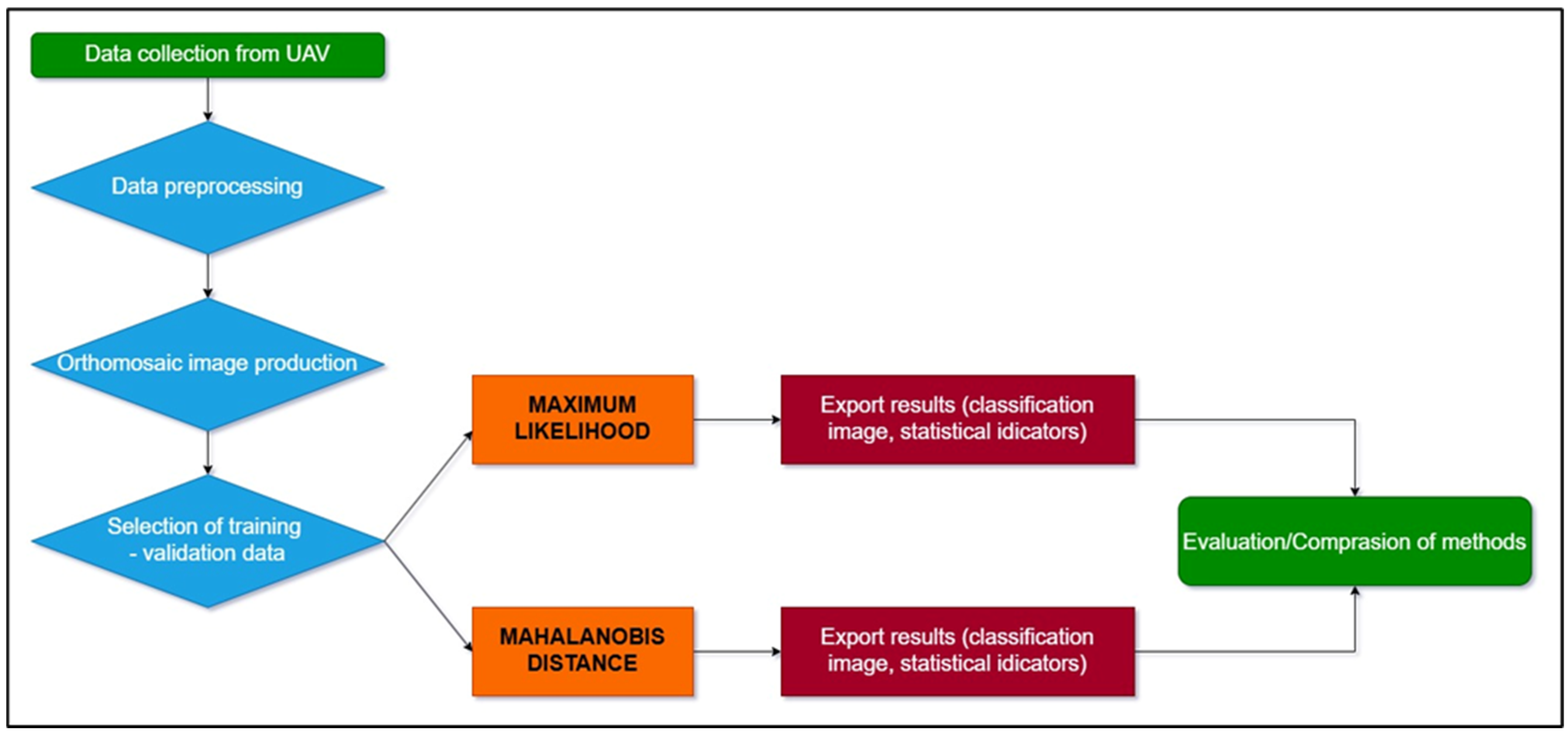
The methodological steps followed to satisfy the study objectives are summarized in Figure 2, which will be presented in more detail in the following sections.

Figure 2.
Flowchart summarizing the methodological steps applied to achieve the study objectives.
3.1. Subsection
The collected image data were pre-processed to ensure their accuracy and quality. The first phase of pre-processing involved geometric correction of the images to eliminate potential errors in georeferencing. Pix4DengineSDK version 5.0.45 software was used, enabling the creation of orthomosaics and the analysis of the spatial distribution of points [12,33].
Spectral correction was the next critical step, ensuring noise removal and enhancement of the spectral signatures in the images [30]. Spectral correction, as described by [44], is essential for maintaining spectral accuracy by correcting variations in lighting and capture angles. Spectral enhancement filters were applied to improve data quality and achieve more accurate analysis of spectral features [31]. According to [45], geometric correction of images and spectral pre-processing are vital for analytical accuracy, as they reduce errors caused by Earth curvature and varying lighting conditions. Quality control of the images was conducted using statistical criteria, such as keypoint analysis, where the average number of keypoints per image was 74,458 [46]. Image quality control, as noted by [9], is critical for ensuring data reliability and reducing classification errors.
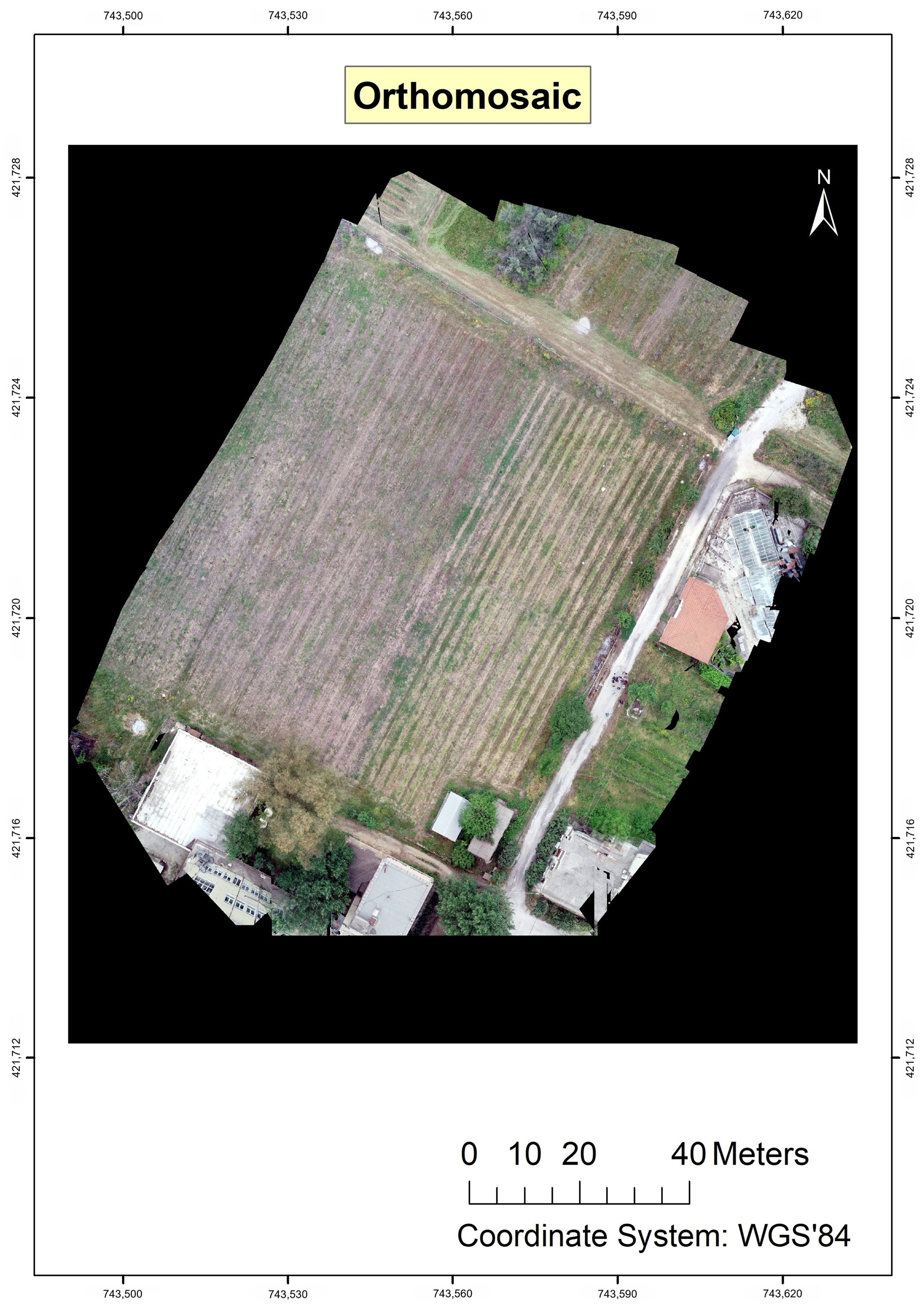
As the next step in pre-processing, an orthomosaic and a Digital Surface Model (DSM) were generated from the data collected by the UAV. This process involved geometric correction and the composition of individual images into a single, high-accuracy georeferenced representation (see Figure 3). The DSM provided information on the area’s topography, facilitating land cover data analysis [29,38].

Figure 3.
The generated orthomosaic of the study area as produced upon completion of dataset pre-processing.
A critical aspect of the pre-processing procedure is the creation of the DSM (Digital Surface Model) and DEM (Digital Elevation Model). The DSM was generated to depict the elevation variations of the area, providing information on the terrain features. The DEM was used to remove natural objects such as vegetation and structures, enabling a more accurate analysis of the topography in the study area. Both models contributed to understanding the spatial structure and improving the accuracy of classifications [6,47].
3.2. Main Processing
3.2.1. Classification Scheme Development
The first step of the main processing involved developing the classification scheme that would be used in deriving the LULC maps from the pre-processed UAV imagery. The selection of classification categories was based on the dominant land cover features of the study area, including urban, agricultural, natural, and mixed uses (Table 1). Subsequently, the training samples were selected to fully represent the variety of land cover types in the study area, considering their spectral separability as assessed through statistical methods. This selection ensured that different categories were adequately represented, minimizing the risk of spectral overlap and enhancing the accuracy of the final classifications. Regions of Interest (ROIs) were determined based on visual analysis and detailed knowledge of local characteristics [40]. The number of training fields varied by category, aiming to make the distribution as representative as possible in relation to the area covered by each land cover type [30].

Table 1.
The land cover categories classified.
The spectral correction process minimized radiometric distortions caused by atmospheric conditions and sensor limitations. This was achieved through relative radiometric correction using standard calibration targets placed in the study area during UAV flights [21]. Geometric corrections were also applied to the imagery to account for terrain variations and flight path deviations, ensuring the geometric integrity of the orthomosaics and improving the reliability of the classification results. Finally, vegetation indices such as NDVI were calculated to enhance the spectral differentiation between land cover classes, particularly for vegetation-related categories [48,49].
Particular attention was given to the separability of training points to ensure unbiased collection. The Z-profile function in ENVI 5.3 software was utilized to identify the spectral signatures of various land cover types, such as low vegetation, agricultural areas, and urban zones [28,33]. Spectral analysis played a crucial role in the successful application of the classification methods, enabling precise data classification based on spectral differences [11]. Additionally, the spectral separability of the points was assessed using statistical methods such as the Jeffries–Matusita index [30] to confirm that the selected categories exhibit sufficient spectral distance from each other. High separability of training points is an important process, as it reduces the risk of overlaps and increases the accuracy of final classification results.
Validation points were selected separately to avoid influencing the training process, ensuring an objective evaluation of the results. The training-to-validation data ratio was 82.8% of the data for training and the remaining 17.2% for validation, which ensured a sufficient number of points for model training while maintaining a representative set for accuracy assessment [46]. The choice of this specific ratio was informed by previous studies [46], which demonstrated that an 80:20 or similar split provides a balanced trade-off between model training and independent validation. This ratio ensures that the training set is large enough to capture the spectral variability within each land cover class, minimizing underfitting, while the validation set remains statistically representative of the overall dataset. Moreover, validation points were selected in a stratified manner, ensuring that all land cover categories were adequately represented in both training and validation datasets. This approach enhances the reliability of accuracy assessments by reducing potential biases caused by imbalanced sample distributions.
3.2.2. Classification Implementation
The main processing of the collected data to generate the LULC maps involved the implementation of supervised classification methods, specifically MLC and MDC, using ENVI 5.3 software.
MLC is a parametric classifier based on the assumption that spectral data follow a normal distribution [30,31]. This assumption makes MLC particularly effective in regions with distinct land cover classes, where spectral signatures are clearly differentiated. For MLC implementation, the training data were used to create spectral patterns for each land cover category. ENVI 5.3 facilitated the input of these data and the development of models that calculated the likelihood of each pixel belonging to a specific category [12,40]. During processing, each pixel was assigned to the category with the highest probability based on its spectral signature [33]. While MLC proved effective in areas with clear spectral differences [30], it faced challenges in regions where categories had similar spectral properties, an issue amplified by the diverse land uses in the study area [28].
In contrast, MDC is a non-parametric method that does not assume a normal distribution of the data, providing greater flexibility in heterogeneous environments [34]. MDC calculates the statistical dispersion and correlations within the data to determine the distance of each pixel from the center of the category it potentially belongs to [19]. This method accounts for internal variability and spectral consistency, making it more effective in areas with overlapping spectral signatures. The MDC implementation involved providing as input the training data into the software and applying a model that calculated distances for each pixel [16]. Pixels were classified into the category with the shortest distance, ensuring efficiency in areas with spectral complexity and overlap [46].
The statistical assumptions and operational differences of both methods were carefully considered in this study’s experimental set-up, ensuring that both classifiers were evaluated under conditions that highlighted their respective strengths and limitations.
3.2.3. Accuracy Assessment
Accuracy assessment of classification maps, as emphasized by [50], is essential for determining the effectiveness of classification methods applied to high-resolution data. In the present study, the classification results were evaluated based initially on visual comparison of LULC maps generated by each method and subsequently by computing standard classification accuracy assessment metrics for each of the derived classification maps. Those metrics included the overall accuracy (OA), Kappa coefficient (Kc), User’s Accuracy (UA), and Producer’s Accuracy (PA) (e.g., [51]). The OA and Kc provide a measure of the overall accuracy of the classification that was performed. OA is expressed as percentage (%) and is a measure of the proportion of the assessed area that is classified correctly. Kc provides a measure of the difference between the actual agreement between reference data and the classifier used to perform the classification versus the chance of agreement between the reference data and a random classifier. The PA indicates the probability that the classifier has correctly labeled an image pixel whereas the UA expresses the probability that a pixel belongs to a given class and the classifier has labeled the pixel correctly into the same given class.
Visual comparison of the classification maps to evaluate classification accuracy is a commonly used approach. For example, this approach was implemented in the study by [52] in areas with complex land uses, providing valuable insights into the quality of the generated maps. On the other hand, the use of the classification accuracy assessment metrics is the standard accuracy assessment approach (e.g., [53,54]). For example, ref. [55] used the OA and Kc to assess land use maps generated from UAV data.
4. Results
Table 2 summarizes the results from the computation of the classification metrics and Figure 4 illustrates the derived classification maps by the two classifiers. MLC demonstrated an OA of 96.58%, with a Kc of 0.942. These results indicate a high level of reliability in classification, particularly in areas where the spectral signatures of categories were distinct. This accuracy reflects MLC’s ability to leverage the spectral diversity of the data with excellent efficiency.
Table 2.
Evaluation metrics of supervised classification methods by land cover category.
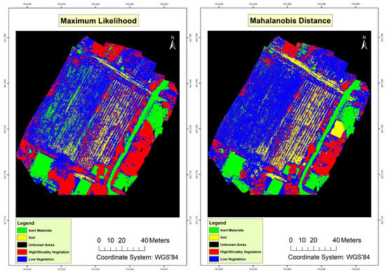
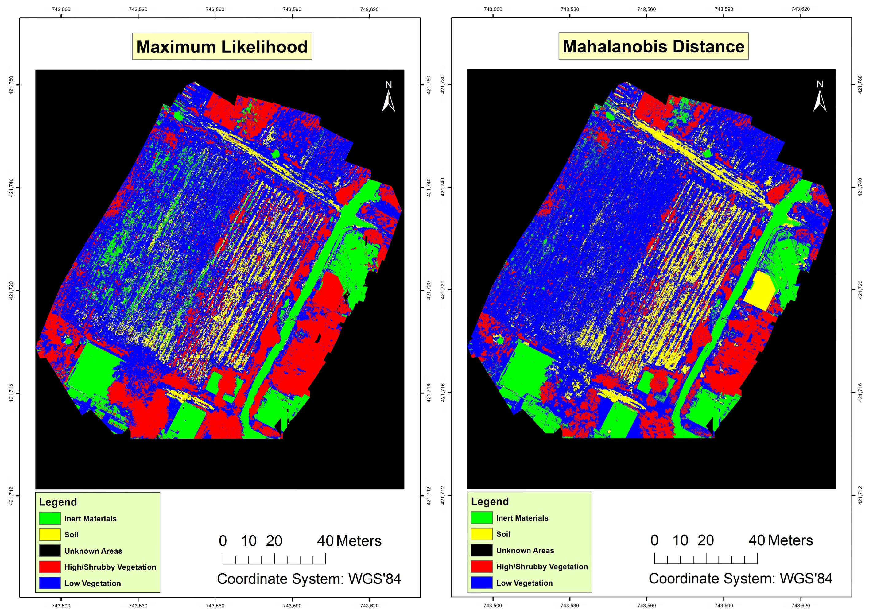
Figure 4.
LULC classification results using MLC (left) and MDC (right). Highlighted areas indicate misclassified regions, particularly in urban zones and ‘Unknown Areas’, where spectral overlap posed significant challenges for both classifiers.
Similarly, MDC showed an OA of 92.77% and a Kc of 0.878 (Table 2). MDC proved reliable in classifying areas with spectral overlap where MLC encountered difficulties. However, the lower OA compared to MLC suggests that MDC is less effective in areas with clearer and more distinct spectral signatures.
The results presented in Table 2 demonstrate distinct performance differences between the MLC and MDC classifiers. MLC outperformed MDC in categories with clear spectral boundaries, such as ‘Vegetation’ and ‘Urban Areas’, achieving higher UA. This superiority is attributed to MLC’s reliance on the assumption of normal distribution, which works effectively in homogeneous regions with distinct class separability. Conversely, MDC demonstrated better performance in spectrally complex regions, such as ‘Unknown Areas’, where it leveraged its sensitivity to spectral variation. However, the lowest agreement is found with the MDC method in the ‘soil’ category (UA 62.99%). This may be attributed to its increased susceptibility to spectral overlap in mixed land use zones, especially in heterogeneous agricultural fields with overlapping spectral signatures. These findings highlight the relative strengths and limitations of the two classifiers, emphasizing the potential added value of hybrid approach development that would allow combining the advantages of each individual classifier. The lower UA for ‘Unknown Areas’ in MDC reflects challenges with spectral overlap, particularly in mixed land use zones. The higher accuracy of MLC in categories with distinct spectral signatures highlights its robustness in such environments.
The generation of LULC maps using the two methods provided the foundation for comparing their performance. Initially, the two classification maps were presented separately, highlighting the spatial distribution of categories produced by each method (Figure 4). The classification map generated using MLC demonstrated a clearer distinction between categories and fewer ambiguities at the boundaries of areas, indicating the superiority of MLC in environments with distinctly separable spectral properties. Conversely, the MDC-produced map exhibited less distinct transitions between categories, reflecting MDC’s ability to recognize categories with overlapping spectral signatures.
Specifically, in areas such as agricultural fields and dense/shrub vegetation, MLC successfully differentiated vegetation cover categories with high accuracy (Table 2), while MDC faced greater challenges in the same areas due to the complexity of spectral properties. On the other hand, in built-up areas where the spectral signatures of construction materials appear almost similar, MDC provided more satisfactory results, accurately identifying regions with spectral overlap. However, a detailed error analysis revealed that MDC struggled significantly in ‘Unknown Areas’, where overlapping spectral signatures from multiple land cover types reduced classification accuracy. Conversely, MLC demonstrated superior performance in categories with distinct spectral boundaries, such as ‘Inert Materials’ and ‘High Vegetation’. These findings highlight the limitations of MDC in mixed land use regions, where spectral separability is crucial for accurate classification, and suggest that MLC may be more appropriate for such areas.
5. Discussion
5.1. Comparison with Previous Studies
The MLC results showed a high overall accuracy (96.58%) and a Kc of 0.942 in LULC mapping, results consistent with previous studies demonstrating the method’s effectiveness in data with clear spectral signatures [30,31]. Ref. [56] on using MLC in agricultural areas yielded similar results, supporting the method’s superiority in regions with well-defined LULC categories. In contrast, MDC, although less accurate, proved valuable in areas with spectral overlap, corroborating the findings of [19], where the method was successfully applied in urban landscapes.
Supervised classification methods, such as MLC and MDC, are often used for RS data analysis, providing high accuracy, particularly when spectral signatures are distinct [30,31]. MLC, based on statistical probability and assuming normal distribution of data, is particularly effective in cases where spectral signatures of categories are distinct in homogeneous data [28,33]. Conversely, MDC accounts for dispersion and correlations among spectral signatures, making it suitable for data with overlapping characteristics [19,34]. Ref. [53] emphasized that MDC outperforms in complex areas with spectral overlap, such as urban and industrial zones. According to [36], integrating traditional classification methods with ML techniques can further enhance performance and accuracy, especially in areas with spectral complexity. The analysis of the results provides insights into factors influencing the performance of the methods and the implications of the findings compared to prior research in the field.
5.2. Sources of Errors and Limitations
Among others, ref. [52] has underlined that the success of classification methods depends on the separability of training points, as spectral overlaps reduce classification accuracy. In this study, the separability of training points was evaluated using the Jeffries–Matusita index, with results indicating high separability (values > 1.8) among most categories. These findings reaffirm the importance of spectral differentiation, as suggested by [43], where high separability was associated with an overall classification accuracy above 90%. These observations highlight that adequate separability not only enhances classification accuracy but also improves result stability across methods.
Several sources of error affecting classification accuracy can be identified. The most common errors may arise from similarities in spectral responses between certain categories, especially in mixed land cover areas [5,41]. Spectral overlap caused ambiguities, particularly in MDC, which struggled to classify categories with shared spectral characteristics. This has also been reported in other similar studies using satellite data [30,31]. Other influencing factors included lighting conditions during data capture and the quality of image pre-processing [18]. Careful spectral and geometric corrections helped reduce errors, but the area’s natural complexity can be another possible factor influencing the results obtained [13,24].
In this context, despite positive results, the present study had several limitations. The accuracy of MLC decreased in areas with overlapping spectral signatures, indicating the need for more flexible methods or hybrid approaches [29,34]. MDC, while efficient in spectrally complex environments, exhibited errors in areas with low spectral diversity, demonstrating that the method is not always the best choice when spectral differentiation is clear [16,30]. Another limitation was the nature of the training and validation data. The selection of ROIs may also generally influence classification accuracy and the representativeness of the results [46].
The performance of both pixel-based classification methods is generally heavily influenced by the quality and representativeness of the training samples. The spectral diversity of the study area allowed for testing the robustness of each classifier under varying conditions. However, the MDC method showed limitations in handling areas with overlapping spectral signatures, leading to reduced accuracy in such cases. In particular, the selection of training samples significantly impacts classification accuracy. In this study, regions with higher spectral separability demonstrated increased accuracy, particularly for the MLC method. Further experiments varying the number of training samples revealed that accuracy plateaued after a certain threshold, highlighting the importance of selecting representative and sufficient training data. For instance, reducing the number of training samples by 30% resulted in a decline in OA for both classifiers (MLC: −5.6%, MDC: −8.2%), underscoring the need for an adequate and balanced sample size across all land cover classes. Additionally, spatially stratified sampling proved effective in reducing misclassification, particularly in categories with complex land cover transitions.
Spectral overlap in ‘Unknown Areas’ was a major source of error, particularly for the MDC method. This challenge was evident in regions with mixed land use, where multiple land cover types exhibited similar spectral signatures. For example, the spectral overlap between low vegetation and bare soil in agricultural areas led to frequent misclassifications. Such errors highlight the need for advanced classification techniques, such as feature extraction and spectral unmixing, to enhance performance. However, more thorough UAV-based classification research incorporating a wide range of pixel-based algorithms must be conducted, in order to identify all potential sources of error and the best-fitting algorithm. Furthermore, the inclusion of multispectral or hyperspectral data in future studies could provide greater spectral detail, thereby improving the differentiation of complex land cover types. To address these limitations, future studies should explore hybrid approaches that combine traditional classifiers with ML methods, such as Random Forests or Support Vector Machines, which are more robust to spectral overlap. Additionally, implementing feature extraction techniques, such as principal component analysis (PCA), could reduce redundancy in the spectral data and highlight key differences between land cover types. Incorporating multispectral or hyperspectral data, as well as texture-based classification metrics, may further enhance the ability to differentiate complex categories in mixed land use areas. Such advancements would mitigate the impact of spectral overlap and improve the reliability of classification results.
5.3. Recommendations for Improvements and Future Research
Prospects for improvement include the use of hybrid methods that combine the advantages of both MLC and MDC. Future studies could explore the use of ML and deep learning techniques, such as neural networks, to enhance classification accuracy [28,38]. Such techniques can exploit the details of high-resolution data and reduce errors arising from spectral signature overlaps [29,30].
Moreover, the study by [57] suggests that incorporating artificial intelligence into classification methods can increase accuracy and mapping speed, particularly in complex areas. ML algorithms such as Random Forests and Support Vector Machines can better manage spectral overlaps and utilize data features more effectively. Advanced approaches based on deep learning technologies like Convolutional Neural Networks (CNNs) have proven particularly effective in handling large volumes of high-resolution data, enabling automated feature extraction [58]. For instance, CNNs can more accurately classify complexities such as mixed land uses or areas with diverse spectral signatures, while the algorithms’ self-training capabilities reduce the need for manual intervention [59]. Integrating such techniques not only improves performance but also reduces the time required for mapping, making RS applications more efficient.
Additionally, incorporating multispectral data from other sources, such as hyperspectral sensors, could improve classification method performance [19,47]. The combined use of UAVs with other RS technologies would enable better understanding and accuracy in land cover mapping. High-resolution UAV data provide conditions for applying new techniques, such as comparing methods based on decision trees and deep learning. Future research could extend to hybrid methods combining the strengths of traditional methods with modern techniques like neural networks [30,38]. Practical strategies for implementing these advanced methods could include the integration of feature extraction techniques, such as PCA, to reduce redundancy in spectral data and focus on key differentiating features. Additionally, combining UAV imagery with multispectral or hyperspectral data can provide richer spectral details to improve classification accuracy in complex land use areas. Deep learning methods, like CNNs, could be used to automate the extraction of spatial and spectral features, enhancing the differentiation of spectrally similar categories. Incorporating texture-based metrics or multi-scale feature extraction approaches would also allow for better handling of spectrally overlapping regions. Such advancements would significantly improve the reliability of classification in mixed and heterogeneous landscapes.
6. Final Remarks
This study focused on the comparative evaluation of two supervised classification methods, MLC and MDC, for LULC mapping using high-resolution UAV data in a Mediterranean agricultural setting located in Greece. Although numerous studies in the literature have compared these classifiers with satellite data, comparative studies using UAV data remain limited, particularly in Mediterranean environments. The present study provides valuable insights into UAV-based LULC mapping, highlighting its potential for detailed and cost-effective applications. However, the novelty of this research lies primarily in its specific application to a Mediterranean agricultural setting, rather than the development of entirely new methodologies. Similar approaches have been applied in other regions, and future research should focus on extending these methods to more diverse and topographically complex Mediterranean landscapes to further validate their effectiveness and applicability.
The findings indicated that MLC is more effective in areas with low spectral overlap, while MDC excels in data with high spectral complexity. Additionally, it was confirmed that training point separability is critical for improving classification accuracy, while UAV data enhance the spectral and spatial detail of land cover maps [24,30]. The results provide valuable insights into the capabilities and limitations of these methods in providing a low-cost LULC mapping and underscore the importance of selecting the appropriate method based on the data’s nature and the analysis requirements. For instance, MLC can be used for mapping agricultural lands with clear categories, while MDC is suitable for urban areas or regions with high spectral complexity [20,41].
The method presented herein is easy and computationally inexpensive to be applied for other small-scale studies, and it is based on low-cost UAV equipment. Indeed, provided that flight permission can be obtained for the site under consideration, the method’s implementation to other sites would require much less effort in comparison, for example, to an approach based on visual image interpretation of UAV imagery. Furthermore, as the proposed approach is dependent on a small number of training points, this helps in producing highly robust and accurate results if the method is implemented on other sites.
Practical applications of the present study findings include improving mapping accuracy in areas with complex land use/cover characteristics. This study highlights the need for further development of classification methods particularly with freely distributed and easily accessible UAV imagery, including the integration of ML and hyperspectral analysis, to improve LULC mapping accuracy and efficiency [28,38]. Also, the development of hybrid classification methods leveraging the strengths of different classifiers can potentially provide an avenue for creating more comprehensive solutions for LULC mapping from low-cost UAV imagery as the one used in the present study, but this remains to be further explored.
Author Contributions
Methodology, I.A.N.; Formal analysis, I.A.N.; Writing—original draft, I.A.N. and G.P.P.; Writing—review & editing, G.P.P.; Supervision, G.P.P. All authors have read and agreed to the published version of the manuscript.
Funding
The participation of George P. Petropoulos in the present work was financially supported by the ACCELERATE MSCA SE program of the European Union’s Horizon 2020 research and innovation program under grant agreement No. 101182930.
Data Availability Statement
The data presented in this study are available on request from the corresponding author, the data are not publicly available due to privacy restrictions.
Conflicts of Interest
The authors declare no conflict of interest.
References
- Feng, Q.; Liu, J.; Gong, J. UAV Remote Sensing for Urban Vegetation Mapping Using Random Forest and Texture Analysis. Remote Sens. 2015, 7, 1074–1094. [Google Scholar] [CrossRef]
- Tsatsaris, A.; Kalogeropoulos, K.; Stathopoulos, N.; Louka, P.; Tsanakas, K.; Tsesmelis, D.E.; Krassanakis, V.; Petropoulos, G.P.; Pappas, V. Geoinformation Technologies in Support of Environmental Hazards Monitoring under Climate Change: An Extensive Review. ISPRS Int. J. Geo-Inf. 2021, 10, 94. [Google Scholar] [CrossRef]
- Dahiya, N.; Singh, G.; Gupta, D.K.; Kalogeropoulos, K.; Detsikas, S.E.; Petropoulos, G.P.; Singh, S.; Sood, V. A novel deep learning change detection approach for estimating spatiotemporal crop field variations from Sentinel-2 imagery. Remote Sens. Appl. Soc. Environ. 2024, 35, 101259. [Google Scholar] [CrossRef]
- Petropoulos, G.P.; Detsikas, S.E.; Kalogeropoulos, K.; Pavlides, A. A First Exploration of the Ts/VI “Analytical Triangle” Technique with UAV Imagery for Deriving Key Surface Energy Balance Parameters at Very High Spatial Resolution. Drones 2024, 8, 290. [Google Scholar] [CrossRef]
- Whitehead, K.; Hugenholtz, C.H.; Myshak, S.; Brown, O.; LeClair, A.; Tamminga, A.; Barchyn, T.E.; Moorman, B.; Eaton, B. Remote Sensing of the Environment with Small Unmanned Aircraft Systems (UASs), Part 2: Scientific and Commercial Applications. J. Unmanned Veh. Syst. 2014, 2, 86–102. [Google Scholar] [CrossRef]
- Sun, J.; Yuan, G.; Song, L.; Zhang, H. Unmanned Aerial Vehicles (UAVs) in Landslide Investigation and Monitoring: A Review. Drones 2024, 8, 30. [Google Scholar] [CrossRef]
- Pádua, L.; Vanko, J.; Hruška, J.; Adão, T.; Sousa, J.J.; Peres, E.; Morais, R. UAS, Sensors, and Data Processing in Agroforestry: A Review towards Practical Applications. Int. J. Remote Sens. 2017, 38, 2349–2391. [Google Scholar] [CrossRef]
- Turner, D.; Lucieer, A.; Watson, C. An Automated Technique for Generating Georectified Mosaics from Ultra-High Resolution Unmanned Aerial Vehicle (UAV) Imagery, Based on Structure from Motion (SfM) Point Clouds. Remote Sens. 2012, 4, 1392–1410. [Google Scholar] [CrossRef]
- Stöcker, C.; Bennett, R.; Nex, F.; Gerke, M.; Zevenbergen, J. Review of the Current State of UAV Regulations. Remote Sens. 2017, 9, 459. [Google Scholar] [CrossRef]
- Petropoulos, G.P.; Maltese, A.; Carlson, T.N.; Provenzano, G.; Pavlides, A.; Ciraolo, G.; Hristopulos, D.; Capodici, F.; Chalkias, C.; Dardanelli, G. Exploring the use of UAVs with the simplified ‘triangle’ technique for Soil Water Content and Evaporative Fraction retrievals in a Mediterranean setting. Int. J. Remote Sens. 2020, 42, 1623–1642. [Google Scholar] [CrossRef]
- Neyns, R.; Canters, F. Mapping of Urban Vegetation with High-Resolution Remote Sensing: A Review. Remote Sens. 2022, 14, 1031. [Google Scholar] [CrossRef]
- Lin, Y.; Hyyppä, J.; Jaakkola, A. Mini-UAV-Borne LIDAR for Fine-Scale Mapping. IEEE Geosci. Remote Sens. Lett. 2010, 8, 426–430. [Google Scholar] [CrossRef]
- Nguyen, H.T.; Lopez Caceres, M.L.; Moritake, K.; Kentsch, S.; Shu, H.; Diez, Y. Individual Sick Fir Tree (Abies mariesii) Identification in Insect Infested Forests by Means of UAV Images and Deep Learning. Remote Sens. 2021, 13, 260. [Google Scholar] [CrossRef]
- Wang, J.; Zhang, H.; Zhang, Y. Application of UAV Remote Sensing in Precision Agriculture: A Review. Remote Sens. 2021, 13, 438. [Google Scholar]
- Petropoulos, G.P.; Detsikas, S.E.; Lemesios, I.; Raj, R. Obtaining LULC distribution at 30-m resolution from Pixxel’s first technology demonstrator hyperspectral imagery. Int. J. Remote Sens. 2024, 45, 4883–4896. [Google Scholar] [CrossRef]
- Rahman, M.; Reza, H. Cost-effective monitoring of natural disasters using drones. Geospat. Sci. J. 2021, 18, 203–217. [Google Scholar]
- Kouvaras, L.; Petropoulos, G.P. A Novel Technique Based on Machine Learning for Detecting and Segmenting Trees in Very High Resolution Digital Images from Unmanned Aerial Vehicles. Drones 2024, 8, 43. [Google Scholar] [CrossRef]
- Tang, L.; Shao, G.; Ding, H. UAV Remote Sensing for Precision Agriculture: A Comparison between Different Cameras for Vegetation Monitoring. Remote Sens. 2021, 12, 1346. [Google Scholar]
- Wang, J.; Xu, Y.; Zhang, L.; Li, Z. Advancing precision agriculture with UAV-based hyperspectral imaging. J. Spectr. Imaging 2021, 10, 221–234. [Google Scholar]
- Breen, D.; Curtis, A.; Graham, J. The Use of Unmanned Aerial Systems for the Mapping of Forests and Peatlands: A Review. Remote Sens. 2020, 12, 2295. [Google Scholar]
- Jakob, S.; Zimmermann, R.; Gloaguen, R. The Need for Accurate Geometric and Radiometric Corrections of Drone-Borne Hyperspectral Data for Mineral Exploration: MEPHySTo—A Toolbox for Pre-Processing Drone-Borne Hyperspectral Data. Remote Sens. 2017, 9, 88. [Google Scholar] [CrossRef]
- Tang, H.; Liu, J.; Zhao, F. UAVs for post-disaster damage assessment: A case study on earthquake monitoring. Disaster Manag. J. 2021, 9, 43–56. [Google Scholar]
- Detsikas, S.E.; Petropoulos, G.P.; Kalogeropoulos, K.; Faraslis, I. Combining Low-Cost UAV Imagery with Machine Learning Classifiers for Accurate Land Use/Land Cover Mapping. Earth 2024, 5, 244–254. [Google Scholar] [CrossRef]
- Santos, M.J.; Fernandes, R.; Almeida, P.; Costa, L. Monitoring environmental changes with UAVs: Opportunities and challenges. Environ. Monit. Rev. 2021, 19, 245–260. [Google Scholar]
- Petropoulos, G.P.; Arvanitis, K.; Sigrimis, N. Hyperion Hyperspectral Imagery Analysis Combined With Machine Learning Classifiers for Land Use/Cover Mapping. Expert Syst. Appl. 2012, 39, 3800–3809. [Google Scholar] [CrossRef]
- Pandey, P.C.; Koutsias, N.; Petropoulos, G.P.; Srivastava, P.K.; Dor, E.B. Land Use/Land Cover in view of Earth Observation: Data Sources, Input Dimensions and Classifiers—A Review of the State of the Art. Geocarto Int. 2019, 36, 957–988. [Google Scholar] [CrossRef]
- Lekka, C.; Petropoulos, G.P.; Detsikas, S.E. Appraisal of EnMAP hyperspectral imagery use in LULC mapping when combined with machine learning pixel-based classifiers. Environ. Model. Softw. 2024, 173, 105956. [Google Scholar] [CrossRef]
- Goodfellow, I.; Bengio, Y.; Courville, A. Deep Learning; MIT Press: Cambridge, MA, USA, 2016. [Google Scholar]
- Zhang, L.; Zhang, L.; Du, B. Deep Learning for Remote Sensing Data: A Technical Tutorial on the State of the Art. IEEE Geosci. Remote Sens. Mag. 2018, 4, 22–40. [Google Scholar] [CrossRef]
- McRoberts, R.E.; Stehman, S.V. The effects of imperfect reference data on remote sensing-assisted estimators of land cover class proportions. Remote Sens. Environ. 2014, 141, 90–98. [Google Scholar] [CrossRef]
- Otukei, J.R.; Blaschke, T. Land Cover Change Assessment Using Decision Trees, Support Vector Machines and Maximum Likelihood Classification Algorithms. Int. J. Appl. Earth Obs. Geoinf. 2020, 12, S27–S31. [Google Scholar] [CrossRef]
- Ahamed, T.; Patel, N. Remote Sensing Applications in Land Use and Cover Change Detection Using MLC and MDC. Springer Environ. Stud. 2022, 10, 321–340. [Google Scholar]
- Russell, S.; Norvig, P. Artificial Intelligence: A Modern Approach, 4th ed.; Pearson: New York, NY, USA, 2021. [Google Scholar]
- Amani, P.J.; Hurtig, A.-K.; Frumence, G.; Kiwara, A.D.; Goicolea, I.; San Sebastián, M. Health insurance and health system (un)responsiveness: A qualitative study with elderly in rural Tanzania. BMC Health Serv. Res. 2021, 21, 1140. [Google Scholar] [CrossRef] [PubMed]
- Ban, Y.; Jacob, A. Object-Based Fusion of Multitemporal Multi-Angle ENVISAT ASAR and HJ-1B Multispectral Data for Urban Land-Cover Mapping. IEEE Trans. Geosci. Remote Sens. 2018, 56, 2837–2848. [Google Scholar]
- Wang, Y.; Yao, Q.; Kwok, J.T.; Ni, L.M. Generalizing from a few examples: A survey on few-shot learning. ACM Comput. Surv. 2020, 53, 1–34. [Google Scholar] [CrossRef]
- Sefercik, U.G.; Kavzoglu, T.; Colkesen, I.; Adali, S.; Dinc, S.; Nazar, M.; Ozturk, M.Y. Land Cover Classification Performance of Multispectral RTK UAVs. Int. Arch. Photogramm. Remote Sens. Spatial Inf. Sci. 2021, XLVI-4/W5-2021, 489–492. [Google Scholar] [CrossRef]
- He, K.; Zhang, X.; Ren, S.; Sun, J. Deep Residual Learning for Image Recognition. In Proceedings of the IEEE Conference on Computer Vision and Pattern Recognition (CVPR), Vancouver, BC, Canada, 18–22 June 2023; pp. 770–778. [Google Scholar]
- Dapke, P.; Syed, A.; Nagare, S.; Bandal, S.; Baheti, M. A Comparative Analysis of Machine Learning Techniques for LULC Classification Using Landsat-8 Satellite Imagery. Int. J. Eng. Geosci. 2025, 10, 84–92. [Google Scholar] [CrossRef]
- Campbell, J.B.; Wynne, R.H. Introduction to Remote Sensing, 5th ed.; Guilford Press: New York, NY, USA, 2011. [Google Scholar]
- Manfreda, S.; McCabe, M.F.; Miller, P.E.; Lucas, R.; Madrigal, V.P.; Mallinis, G.; Ben Dor, E.; Helman, D.; Estes, L.; Ciraolo, G.; et al. On the Use of Unmanned Aerial Systems for Environmental Monitoring. Remote Sens. 2018, 10, 641. [Google Scholar] [CrossRef]
- Bendig, J.; Bolten, A.; Bareth, G. UAV-Based Imaging for Multi-Temporal, Very High Resolution Crop Surface Models to Monitor Crop Growth Variability. Photogramm.–Fernerkund.–Geoinf. 2019, 2013, 551–562. [Google Scholar] [CrossRef]
- Rahman, M.; Reza, H. Evaluating Spectral Separability in UAV-Based Land Cover Classification. Int. J. Appl. Earth Obs. 2022, 18, 102–118. [Google Scholar]
- Lisein, J.; Pierrot-Deseilligny, M.; Bonnet, S.; Lejeune, P. A Photogrammetric Workflow for the Creation of a Forest Canopy Height Model from Small Unmanned Aerial System Imagery. Forests 2013, 4, 922–944. [Google Scholar] [CrossRef]
- Nevalainen, P.; Middleton, M.; Sutinen, R.; Heikkonen, J.; Pahikkala, T. Detecting Terrain Stoniness From Airborne Laser Scanning Data. Remote Sens. 2016, 8, 720. [Google Scholar] [CrossRef]
- Congalton, R.G. A Review of Assessing the Accuracy of Classifications of Remotely Sensed Data. Remote Sens. Environ. 1991, 37, 35–46. [Google Scholar] [CrossRef]
- Santos, T.T.; Messias, C.G.; Moreira, M.A. Assessment of Vegetation Indices for Estimating the Leaf Area Index of Coffee Crops Using Landsat 8 Images. Remote Sens. Appl. Soc. Environ. 2021, 22, 100482. [Google Scholar]
- Akram, M.W.; Vannucci, M.; Buttazzo, G.; Colla, V.; Roccella, S.; Vannini, A.; Caruso, G.; Nesi, S.; Francini, A.; Sebastiani, L. Automating grapevine LAI features estimation with UAV imagery and machine learning. arXiv 2024, arXiv:2411.17897. [Google Scholar]
- Xie, J.; Shen, Y.; Cen, H. Real-time Reflectance Generation for UAV Multispectral Imagery using an Onboard Downwelling Spectrometer in Varied Weather Conditions. arXiv 2024, arXiv:2412.19527. [Google Scholar]
- Gitelson, A.A.; Viña, A.; Arkebauer, T.J.; Rundquist, D.C.; Keydan, G.; Leavitt, B. Remote Estimation of Leaf Area Index and Green Leaf Biomass in Maize Canopies. Geophys. Res. Lett. 2017, 30, 1248. [Google Scholar] [CrossRef]
- Congalton, R.; Green, K. Assessing the Accuracy of Remotely Sensed Data: Principles and Practices; CRC/Lewis Press: Boca Raton, FL, USA, 1999; 137p. [Google Scholar]
- Johnson, M.P.; Lee, S.H. Visual Assessment of Land Cover Maps Derived from High-Resolution Imagery. Int. J. Appl. Earth Obs. Geoinf. 2021, 102, 102456. [Google Scholar]
- Lamine, S.; Petropoulos, G.P.; Singh, S.K.; Szabo, S.; Bachari, N.; Srivastava, P.K.; Suman, S. Quantifying Land Use/land Cover Spatio-temporal Landscape Pattern Dynamics from Hyperion Using SVMs Classifier and FRAGSTATS. Geocarto Int. 2018, 33, 862–878. [Google Scholar] [CrossRef]
- Fragou, S.; Kalogeropoulos, K.; Stathopoulos, N.; Louka, P.; Srivastava, P.K.; Karpouzas, S.; Kalivas, D.P.; Petropoulos, G.P. Quantifying Land Cover Changes in a Mediterranean Environment Using Landsat TM and Support Vector Machines. Forests 2020, 11, 750. [Google Scholar] [CrossRef]
- Smith, J.A.; Brown, L.M.; Davis, K.R. Evaluating Land Use Classification Accuracy Using UAV Data: A Case Study. Remote Sens. 2022, 14, 1234. [Google Scholar]
- Stavrakoudis, D.; Gitas, I.Z. Object-Based Burned Area Mapping with Extreme Gradient Boosting Using Sentinel-2 Imagery. J. Geogr. Inf. Syst. 2023, 15, 53–72. [Google Scholar] [CrossRef]
- Colomina, I.; Molina, P. Unmanned Aerial Systems for Photogrammetry and Remote Sensing: A Review. ISPRS J. Photogramm. Remote Sens. 2014, 92, 79–97. [Google Scholar] [CrossRef]
- Zhu, X.; Tuia, D.; Mou, L.; Xia, G.-S.; Zhang, L.; Xu, F.; Fraundorfer, F. Deep learning in remote sensing: A comprehensive review and roadmap. IEEE Geosci. Remote Sens. Mag. 2017, 5, 8–36. [Google Scholar] [CrossRef]
- Osco, L.P.; Marcato, J., Jr.; Ramos, A.P.M.; Jorge, L.A.C.; Fatholahi, S.N.; Silva, J.A.; Matsubara, E.T.; Pistori, H.; Gonçalves, W.N.; Li, J. A Review on Deep Learning in UAV Remote Sensing. Int. J. Appl. Earth Obs. Geoinf. 2022, 112, 102456. [Google Scholar] [CrossRef]


Disclaimer/Publisher’s Note: The statements, opinions and data contained in all publications are solely those of the individual author(s) and contributor(s) and not of MDPI and/or the editor(s). MDPI and/or the editor(s) disclaim responsibility for any injury to people or property resulting from any ideas, methods, instructions or products referred to in the content. |
© 2025 by the authors. Licensee MDPI, Basel, Switzerland. This article is an open access article distributed under the terms and conditions of the Creative Commons Attribution (CC BY) license (https://creativecommons.org/licenses/by/4.0/).