Evaluation of the Coordinated Development of the “Population–Economy” in Counties Within the Beijing–Tianjin–Hebei Urban Agglomeration
Abstract
1. Introduction
2. Overview of Coordinated Development in the BTHUA and Data Processing
2.1. Overview of Coordinated Development in the BTHUA
2.2. Sources and Processing of Basic Data
3. Method
3.1. Research Objectives and Technical Framework
3.2. Construction of an Evaluation Indicator System
3.3. Construction of a Comprehensive Evaluation Model
3.4. Spatial–Temporal Characteristic Analysis Methods
3.4.1. Spatial Autocorrelation Analysis
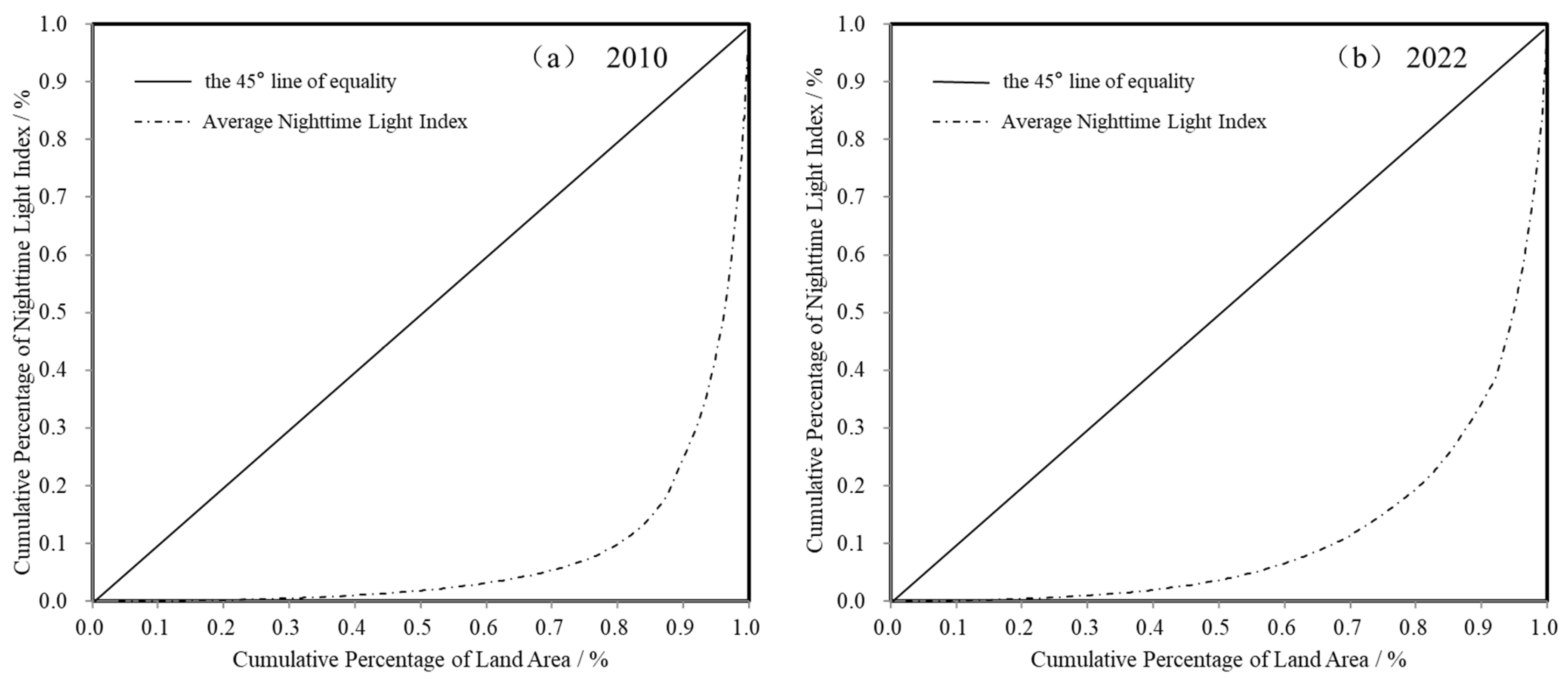
3.4.2. Gini Coefficient
4. Results and Analysis
4.1. Spatial–Temporal Characteristics of Population Distribution in Counties Within the BTHUA
4.1.1. Spatial–Temporal Characteristics of Single Indicators for Population Distribution in Counties
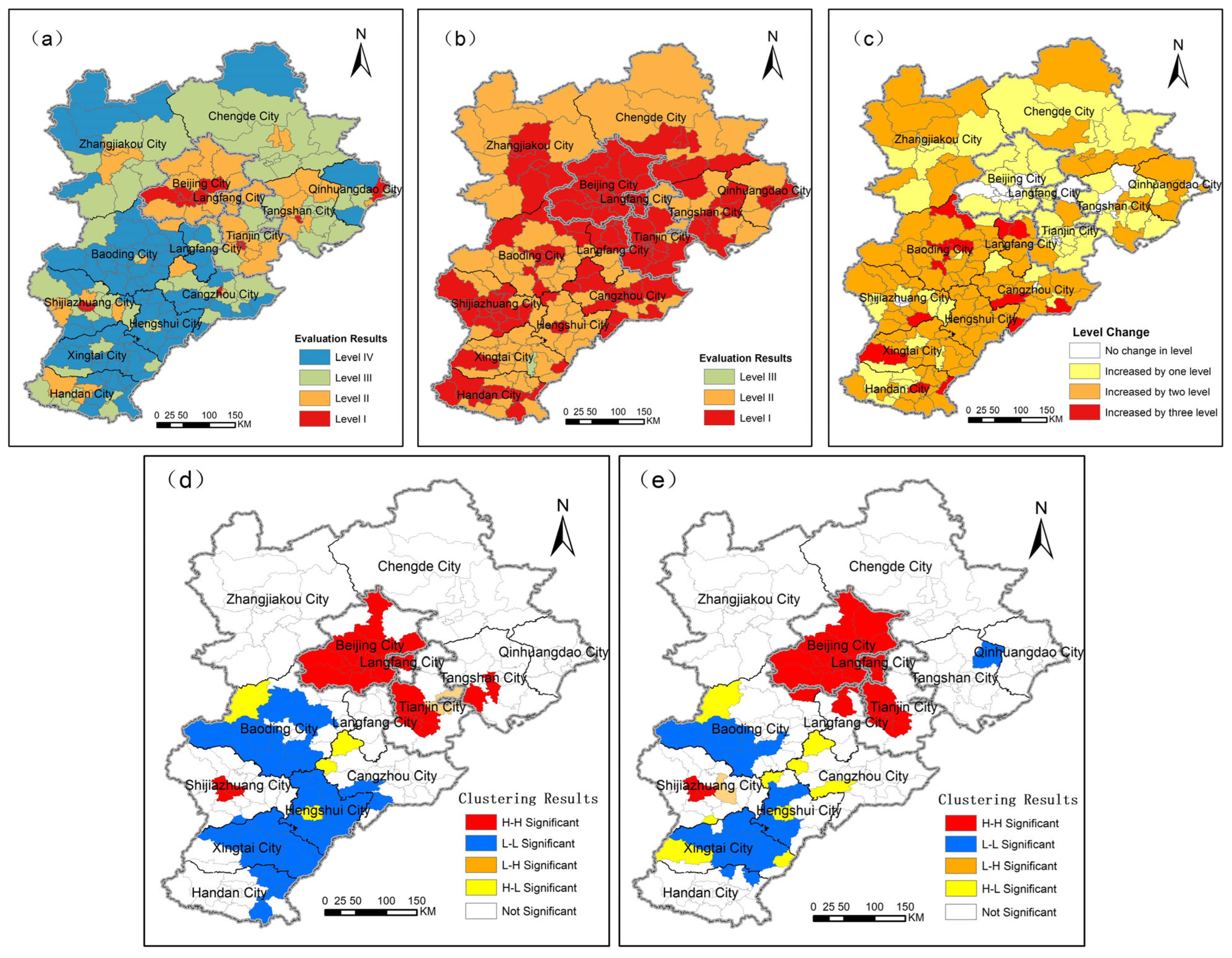
4.1.2. Spatial–Temporal Characteristics of Population Distribution Indicators for the Counties
4.2. Spatial–Temporal Characteristics of Economic Development in Counties Within the BTHUA
4.2.1. Spatial–Temporal Characteristics of Single Indicators for Economic Development in Counties
4.2.2. Spatial–Temporal Characteristics of Economic Development Indicators for Counties
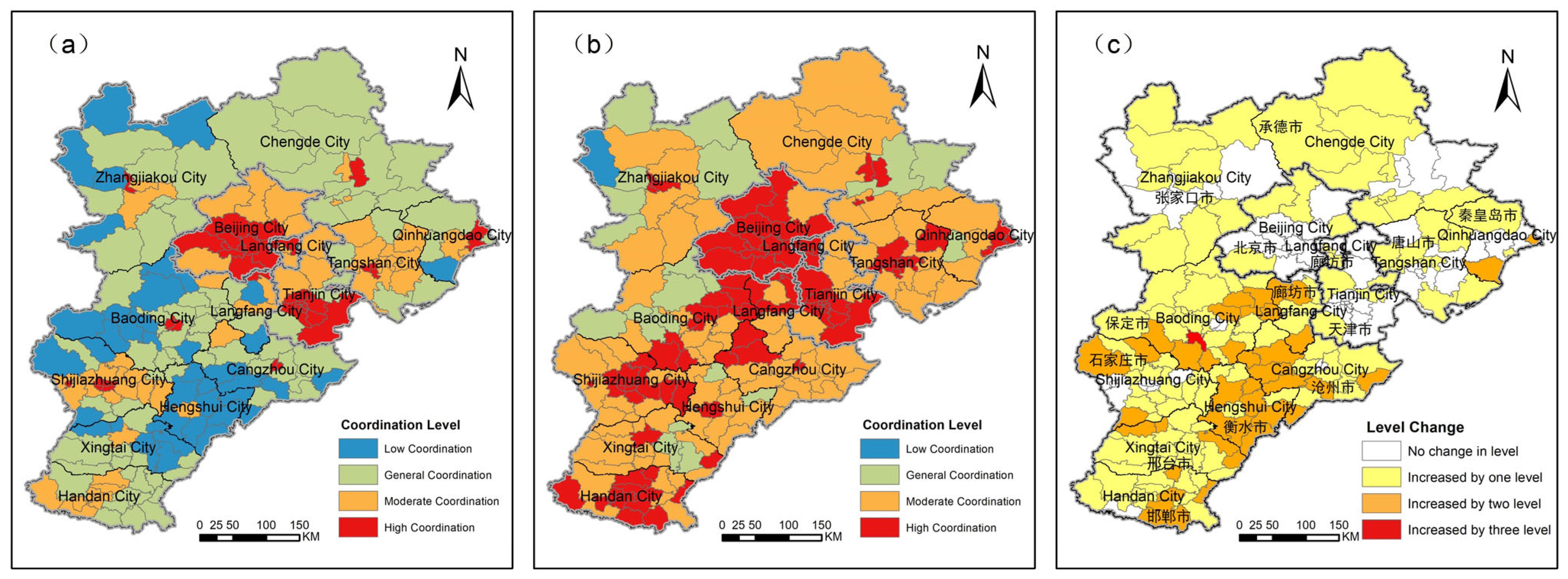
4.3. Analysis of the “Population–Economy” Coupling Coordination in Counties Within the BTHUA
4.4. Countermeasures for the Coordinated Development of the “Population–Economy” in Counties Within the BTHUA
4.4.1. Guiding Orderly Population Flow to the Achieve Coordinated Development of the Human–Land Relationship in the BTHUA
4.4.2. Promoting Regional Industrial Collaboration to Accelerate High-Quality Economic Development in the BTHUA
5. Conclusions
Author Contributions
Funding
Data Availability Statement
Acknowledgments
Conflicts of Interest
References
- Gharbia, S.S.; Alfatah, S.A.; Gill, L.; Johnston, P.; Pilla, F. Land use scenarios and projections simulation using an integrated GIS cellular automata algorithms. Model. Earth Syst. Environ. 2016, 2, 151. [Google Scholar] [CrossRef]
- Dong, Y.; Jin, G.; Deng, X. Optimization of territorial space layout in China. Acta Geogr. Sin. 2024, 79, 672–687. [Google Scholar] [CrossRef]
- Chen, M. Coupling and coordinated evolution of transport-industry-urban scale in Beijing-Tianjin-Hebei urban agglomeration. Econ. Geogr. 2022, 42, 96–102, 185. [Google Scholar]
- Li, Q.; Li, D.; Wang, J.; Wang, S.; Wang, R.; Fu, G.; Yuan, Y.; Zheng, Z. Spatial heterogeneity of ecosystem service bundles and the driving factors in the Beijing-Tianjin-Hebei region. J. Clean. Prod. 2024, 479, 144006. [Google Scholar] [CrossRef]
- Koroso, N.H.; Lengoiboni, M.; Zevenbergen, J.A. Urbanization and urban land use efficiency: Evidence from regional and Addis Ababa satellite cities, Ethiopia. Habitat Int. 2021, 117, 102–437. [Google Scholar] [CrossRef]
- Hao, Q.; Deng, L.; Feng, Z. The “Double Evaluation” under the context of spatial planning: Wicked problems and restricted rationality. J. Nat. Resour. 2021, 36, 541–551. [Google Scholar] [CrossRef]
- Feng, G.; Wang, R.; Xie, Y. The connotation of territorial space from the perspective of national governance. China Land Sci. 2021, 35, 8–16. [Google Scholar]
- Lu, D.; Ye, J.; Xue, D. Urban agglomerations: Growth poles and power sources for high-quality development. Sci. Technol. Rev. 2021, 39, 62–64. [Google Scholar]
- Lin, J.; Liu, G.; Wang, P. Analysis of territorial spatial planning management from the perspective of natural resource supervision: Based on the allocation of spatial development rights. Planners 2024, 40, 1–7. [Google Scholar]
- Fan, J.; Wu, J.; Gao, X. Spatial characteristics of major function achievements in China’s urbanized areas over the past decade and future layout optimization. Econ. Geogr. 2024, 44, 1–13. [Google Scholar]
- Zhai, D. Identification, attribution, and resolution of territorial space conflict in urban agglomerations. City Plan. Rev. 2024, 48, 71–84. [Google Scholar]
- Li, S.; Zhao, X.; Pu, J.; Miao, P.; Wang, Q.; Tan, K. Optimize and control territorial spatial functional areas to improve the ecological stability and total environment in karst areas of Southwest China. Land Use Policy 2021, 100, 104940. [Google Scholar] [CrossRef]
- Li, X.; Kuang, W. Spatio-temporal trajectories of urban land use change during 1980-2015 and future scenario simulation in Beijing-Tianjin-Hebei urban agglomeration. Econ. Geogr. 2019, 39, 187–194, 200. [Google Scholar]
- Zhai, Y.; Zhai, G.; Yu, Z.; Lu, Z.; Chen, Y.; Liu, J. Coupling coordination between urbanization and ecosystem services value in the Beijing-Tianjin-Hebei urban agglomeration. Sustain. Cities Soc. 2024, 113, 105715. [Google Scholar] [CrossRef]
- Zheng, H.; Gu, R. Characteristics of carbon emission network and evaluation of emission reduction synergy in the Beijing-Tianjin-Hebei urban agglomeration. Environ. Sci. 2024, 1–17. [Google Scholar] [CrossRef]
- Song, C.; Sun, C.; Xu, J.; Fan, F. Establishing coordinated development index of urbanization based on multi-source data: A case study of Guangdong-Hong Kong-Macao Greater Bay Area, China. Ecol. Indic. 2022, 140, 109030. [Google Scholar] [CrossRef]
- Li, Y.; Miao, Y. A comparative study on the coordinated development of Beijing-Tianjin-Hebei urban agglomeration based on gravity model. J. Beijing Jiaotong Univ. (Soc. Sci. Ed.) 2022, 21, 78–91. [Google Scholar]
- Ma, W.; Gao, H. Impact of high-speed railway network improvement on consumption synergy in Beijing-Tianjin-Hebei region. Transp. Policy 2024, 158, 29–41. [Google Scholar] [CrossRef]
- Shang, H.; Liu, J. Policy effect and spatial differentiation of Beijing-Tianjin-Hebei coordinated development. Acta Geogr. Sin. 2024, 79, 2020–2041. [Google Scholar]
- Liu, Z.; Yuan, Q.; Li, C.; Gao, L.; Xu, J. Research on the synergistic effect of low-carbon economy and high-quality development under the “dual-carbon” strategy: A case study of Beijing-Tianjin-Hebei urban agglomeration. Environ. Sci. 2024, 45, 6301–6312. [Google Scholar]
- Wu, Z.; Zu, J.; Shi, Y.; Hao, J. Identification and evaluation of production-living-ecological space from the perspective of urban function: Taking the Beijing-Tianjin-Hebei urban agglomeration as an example. Resour. Sci. 2022, 44, 2247–2259. [Google Scholar] [CrossRef]
- Wang, T.; Yue, W. Optimizing territorial spatial pattern for carbon sink growth: Theoretical framework and action logic. J. Nat. Resour. 2024, 39, 1008–1021. [Google Scholar] [CrossRef]
- Lu, Z.; Zhang, M.; Hu, C.; Ma, L.; Chen, E.; Zhang, C.; Xia, G. Spatiotemporal Changes and Influencing Factors of the Coupled Production–Living–Ecological Functions in the Yellow River Basin, China. Land 2024, 13, 1909. [Google Scholar] [CrossRef]
- Chen, Y.; Song, J.; Zhong, S.; Liu, Z.; Gao, W. Effect of destructive earthquake on the population-economy-space urbanization at county level: A case study on Dujiangyan county, China. Sustain. Cities Soc. 2022, 76, 103345. [Google Scholar] [CrossRef]
- Fan, J.; Lian, Y.; Zhao, H. Review of the research progress in Beijing-Tianjin-Hebei region since 1980. Acta Geogr. Sin. 2022, 77, 1299–1319. [Google Scholar]
- Li, G.; Lv, S. Research on the technological innovation and industrial synergistic development in Beijing-Tianjin-Hebei. J. Cap. Univ. Econ. Bus. 2024, 26, 27–37. [Google Scholar]
- Lu, D. Function orientation and coordinating development of subregions within the Jing-Jin-Ji urban agglomeration. Prog. Geogr. 2015, 34, 265–270. [Google Scholar]
- Fang, C.; Cui, X.; Li, G.; Bao, C.; Wang, Z.; Ma, H.; Sun, S.; Liu, H.; Luo, K.; Ren, Y. Modeling regional sustainable development scenarios using the urbanization and eco-environment coupler: Case study of Beijing-Tianjin-Hebei urban agglomeration, China. Sci. Total Environ. 2019, 689, 820–830. [Google Scholar] [CrossRef]
- Wang, D.; Pang, X. Research on green land-use efficiency of Beijing-Tianjin-Hebei urban agglomeration. China Popul. Resour. Environ. 2019, 29, 68–76. [Google Scholar]
- Ouyang, X.; Zhu, X. Spatio-temporal characteristics of urban land expansion in Chinese urban agglomerations. Acta Geogr. Sin. 2020, 75, 571–588. [Google Scholar]
- Li, W.; Lv, X.; Wang, C.; Han, L. Interactions between urbanization, land, water, and carbon and their combined effects on Beijing-Tianjin-Hebei urban agglomeration. Acta Ecol. Sin. 2021, 41, 4318–4329. [Google Scholar]
- Lu, Z.; Zhang, Z. Research on regional variability in the evolution of territorial space pattern and its driving factors in Beijing-Tianjin-Hebei region. China Land Sci. 2022, 36, 42–52. [Google Scholar]
- Wu, J.; Tang, S.; Gao, L.; Wang, Z. Evaluation of land space utilization quality in Beijing-Tianjin-Hebei coordinated development area. J. Hebei Norm. Univ. (Nat. Sci.) 2022, 46, 316–324. [Google Scholar]
- Hu, Q.; Wang, X.; Shen, W.; Zhang, Z. Study on the balanced development of territorial space functions in urban agglomerations: Taking Beijing-Tianjin-Hebei region as an example. China Land Sci. 2023, 37, 53–65. [Google Scholar]
- Zhao, Z.; Wang, J.; Feng, J. Research on the spatial correlation of central cities in Beijing-Tianjin-Hebei urban agglomeration. Econ. Geogr. 2017, 37, 60–66, 75. [Google Scholar]
- Ma, L.; Shi, D. Study on green collaborative development process of Beijing-Tianjin-Hebei region through re-examination of spatial environmental Kuznets curve. China Soft Sci. 2017, 10, 82–93. [Google Scholar]
- Pan, Y.; Weng, G.; Sheng, K.; Xiao, Y. Analysis of the spatiotemporal evolution characteristics and spatial difference of “Tourism +” system coordinated development in the Yangtze River Economic Belt. Resour. Environ. Yangtze Basin 2020, 29, 1897–1909. [Google Scholar]
- Yue, W.; Xia, H.; Zhang, X. Territorial spatial governance for high-quality urban agglomerations development: Insights from the Yangtze River Delta and Guangdong-Hong Kong-Macao Greater Bay Area. Trop. Geogr. 2024, 44, 2129–2141. [Google Scholar]
- Li, R.; Shan, J.; Zhao, J.; Hu, H.; Liu, D.; Wang, G.; Li, Y. Spatio-temporal evolution and obstacle factors of territorial utilization quality in the Bohai Rim. Geogr. Res. 2024, 43, 736–753. [Google Scholar]
- Li, Y.; Li, X.; Liao, C.; Jiang, L.; Hong, W.; Wang, W.; Guo, R. On the collaborative technical framework of land spatial governance driven by high-quality development. Bull. Surv. Mapp. 2024, 3, 95–100, 144. [Google Scholar]
- Cliff, A.D.; Ord, J.K. Spatial Autocorrelation; Springer: Berlin/Heidelberg, Germany, 1973. [Google Scholar]
- Anselin, L. Local indicators of spatial association-LISA. Geogr. Anal. 1995, 27, 93–115. [Google Scholar] [CrossRef]
- Zhang, X.; Feng, Z. Spatial autocorrelation analysis of China’s per capita GDP. Econ. Geogr. 2008, 28, 189–194. [Google Scholar]
- Griffith, D.A. Spatial autocorrelation: A statistician’s reflections. In Advances in Spatial Science; Springer: Berlin/Heidelberg, Germany, 2007; pp. 255–278. [Google Scholar]
- Griffith, D.A. Spatial autocorrelation. In Handbook of Applied Spatial Analysis; Springer: Berlin/Heidelberg, Germany, 2009; pp. 255–278. [Google Scholar]
- Xie, H.; Liu, L.; Li, B.; Zhang, X. Spatial autocorrelation analysis of multi-scale land-use changes: A case study in Ongniud Banner, Inner Mongolia. Acta Geogr. Sin. 2006, 4, 389–400. [Google Scholar]
- Zhang, X. Data Analysis Method and Applied Research of Spatial Autocorrelation: A Case Study in the Influence of South Asian Tsunami on the Marine Ecological Factors. Doctoral dissertation, Lanzhou University, Lanzhou, China, 2009. [Google Scholar]
- Chen, Y. Reconstructing the mathematical process of spatial autocorrelation based on Moran’s statistics. Geogr. Res. 2009, 28, 1449–1463. [Google Scholar]
- Gini, C. Measurement of inequality of incomes. Econ. J. 1921, 31, 124–126. [Google Scholar] [CrossRef]
- Dagum, C. A new approach to the decomposition of the Gini income inequality ratio. Empir. Econ. 1997, 22, 515–531. [Google Scholar] [CrossRef]


| Criterion Layer | Evaluation Indicator | Indicator Meaning | Calculation Formula | Data Source |
|---|---|---|---|---|
| Population Distribution Status | PD (people/ha) | The number of residents per unit of territorial area, reflecting the population density on regional land. | The population of permanent residents in a county/the territorial area in the county | Land cover data; Statistical Yearbook |
| CPD (people/ha) | The number of residents per unit of construction land area, reflecting the population density on regional construction land. | The population of permanent residents in a county/the construction area in the county | Land cover data; Statistical Yearbook | |
| ANLI | The average nighttime light indicator of a certain area, reflecting the average light intensity or density and the degree of change in human activities at night. | Total nighttime light indicator of a county/the territorial area of the county | Nighttime light data (2000–2023) | |
| Economic Development Features | CGDP (CNY 10,000/ha) | GDP output per unit area of construction land, reflecting the development and use efficiency of construction land. | The secondary and tertiary industry-added value of a county/the construction area of the county | Land cover data; Statistical Yearbook |
| RIS | The composition among various industrial sectors of a county’s national economy and within each industrial sector, reflecting the economic development level of the county and changes in development stages. In this study, this indicator was reflected by the proportion of tertiary industry added value. | The tertiary industry added value of a county/the GDP of the county | Statistical Yearbook | |
| PCDI (CNY 10,000) | The income available for free disposal by residents, reflecting the economic status and purchasing power of residents in a region. | Average personal disposable income in a county | Statistical Yearbook | |
| PCPBR (CNY/people) | The total public budget revenue over a certain period (e.g., one year) divided by the average population during that period, reflecting the government’s investment level in public services, infrastructure construction, etc., as well as residents’ financial welfare. | The public budget revenue in a county/the population of permanent residents in the county | Statistical Yearbook |
| Evaluation Indicator | Standardized Value | Weight | ||||
|---|---|---|---|---|---|---|
| 1.0 | 0.8 | 0.6 | 0.4 | 0.2 | ||
| PD | ≥18 | 10~18 | 6~10 | 2~6 | <2 | 0.3690 |
| CPD | ≥110 | 110~60 | 40~60 | 30~40 | <30 | 0.3413 |
| ANLI | ≥5 | 1~5 | 0.3~1 | 0.1~0.3 | <0.1 | 0.2897 |
| CGDP | ≥500 | 150~500 | 80~150 | 50~80 | <50 | 0.2702 |
| RIS | ≥0.6 | 0.45~0.60 | 0.35~0.45 | 0.25~0.35 | <0.25 | 0.2545 |
| PCDI | ≥25000 | 15,000~25,000 | 10,000~15,000 | 6000~10,000 | <6000 | 0.2480 |
| PCPBR | ≥5000 | 2000~5000 | 1000~2000 | 500~1000 | <500 | 0.2272 |
| Evaluation Indicator | Moran’s I | Gini Coefficient | ||
|---|---|---|---|---|
| 2010 | 2022 | 2010 | 2022 | |
| PD | 0.664 | 0.668 | 0.55 | 0.58 |
| CPD | 0.615 | 0.639 | 0.29 | 0.29 |
| ANLI | 0.512 | 0.506 | 0.82 | 0.76 |
| Evaluation Indicator | Moran’s I | Gini Coefficient | ||
|---|---|---|---|---|
| 2010 | 2022 | 2010 | 2022 | |
| CGDP | 0.368 | 0.438 | 0.57 | 0.53 |
| RIS | 0.466 | 0.521 | 0.28 | 0.20 |
| PCDI | 0.705 | 0.749 | 0.31 | 0.29 |
| PCPBR | 0.510 | 0.373 | 0.58 | 0.42 |
Disclaimer/Publisher’s Note: The statements, opinions and data contained in all publications are solely those of the individual author(s) and contributor(s) and not of MDPI and/or the editor(s). MDPI and/or the editor(s) disclaim responsibility for any injury to people or property resulting from any ideas, methods, instructions or products referred to in the content. |
© 2025 by the authors. Licensee MDPI, Basel, Switzerland. This article is an open access article distributed under the terms and conditions of the Creative Commons Attribution (CC BY) license (https://creativecommons.org/licenses/by/4.0/).
Share and Cite
Ren, Y.; Zhang, Y.; Li, S.; Liu, Y.; Yao, L.; Tang, L. Evaluation of the Coordinated Development of the “Population–Economy” in Counties Within the Beijing–Tianjin–Hebei Urban Agglomeration. Land 2025, 14, 590. https://doi.org/10.3390/land14030590
Ren Y, Zhang Y, Li S, Liu Y, Yao L, Tang L. Evaluation of the Coordinated Development of the “Population–Economy” in Counties Within the Beijing–Tianjin–Hebei Urban Agglomeration. Land. 2025; 14(3):590. https://doi.org/10.3390/land14030590
Chicago/Turabian StyleRen, Yanmin, Yanyu Zhang, Shuhua Li, Yu Liu, Lan Yao, and Linnan Tang. 2025. "Evaluation of the Coordinated Development of the “Population–Economy” in Counties Within the Beijing–Tianjin–Hebei Urban Agglomeration" Land 14, no. 3: 590. https://doi.org/10.3390/land14030590
APA StyleRen, Y., Zhang, Y., Li, S., Liu, Y., Yao, L., & Tang, L. (2025). Evaluation of the Coordinated Development of the “Population–Economy” in Counties Within the Beijing–Tianjin–Hebei Urban Agglomeration. Land, 14(3), 590. https://doi.org/10.3390/land14030590


