Abstract
The ecosystems and human social systems in karst areas are undergoing rapid development. In this context, effectively identifying changes in the various functions of karst areas is crucial for formulating accurate sustainable development policies. However, few studies have discussed the ecological, production, and social functions of karst areas within an integrated framework. Therefore, this paper utilizes comprehensive evaluation methods, standard deviation classification, and coordination models to analyze the spatiotemporal changes in these functions of karst areas from 2000 to 2020. The results indicate that over the 20-year period, the ecological function, production function, and social function in karst areas have shown an annual growth trend with noticeable spatiotemporal differentiation. The dominant functions of the area have undergone significant changes, with the ecological function being dominant in 2000, the production function becoming dominant in 2010, and the social function taking the lead in 2020. Over the past 20 years, the lagged development type has remained the predominant combined function type. The coordination levels among the three functions have significantly improved, with the coordination between the ecological function and the production function transitioning from non-coordination to coordination in 2010. Furthermore, the coordination between the ecological function and the social function, and between the production function and the social function, achieved coordination status in 2020. This study enhances the understanding of the multifunctional evolution in karst areas and provides theoretical and practical guidance for ecological restoration, industrial development, and social reconstruction in karst areas.
1. Introduction
Karst areas cover approximately 12% of the world’s territorial area and support the livelihoods of around 1.8 billion people [1]. Due to the complexity of the ecological environment, the diversity of development objectives, and the range of social demands in this area, a variety of functions emerge, which demonstrate significant temporal variability [2,3,4]. The South China Karst, in particular, represents the most typical, complex, and ecologically diverse area within the global tropical-subtropical karst landscape [5]. Currently, this region is undergoing rapid ecological improvement and urbanization, with the implementation of ecological restoration projects and targeted poverty alleviation initiatives resulting in profound changes in human–environment interactions, which are reflected in shifts in regional functions [6,7]. The South China Karst is one of the most ecologically fragile regions globally, where the karst environment plays a critical role in providing essential ecological, production, and social functions to the local people.
Ecological function refers to the ability of ecosystems to provide ecosystem services to local residents [8]. The karst ecosystem faces numerous challenges, including soil erosion, land degradation, and biodiversity loss [9]. Scholars have explored the relationships between vegetation and soil at the micro-scale [10], as well as assessing the value of ecosystem services at the macro-scale [11] and carbon sequestration capacity [12,13]. These studies indicate that forest management practices over the past two decades have led to significant improvements in the region’s ecological functions [14]. The production function is primarily associated with the land’s production capacity and the production capabilities of the rural population, encompassing both agricultural and non-agricultural production functions [15]. Over the past 20 years, in order to protect the ecological environment, steep cultivated land in karst areas has been converted into orchards and other forms of agricultural land [16,17]. As a consequence, the agricultural structure in the karst has been optimized, and the output value per unit area of land has significantly increased [18]. Moreover, the ecological awareness and production capacity of the rural population have improved. Social functions are primarily evident in areas such as education, healthcare, and infrastructure development. With the rapid acceleration of urbanization, the social service levels in karst areas have significantly improved, leading to enhanced quality of life for residents and a reduction in poverty [19]. Specifically, the implementation of targeted poverty alleviation policies has provided residents in the karst region with greater social security and development opportunities [20,21,22].
In regional management, the ecological, production, and living functions are considered fundamental, with their interactions exhibiting clear dynamic characteristics [23,24]. As a result, the sustainability of regional development largely hinges on the harmonious interaction between ecological, production, and social functions [25]. Therefore, effectively identifying changes in the multiple functions and their interrelationships in karst areas is essential for understanding regional development patterns and for formulating more precise and effective sustainable development policies. Currently, research on regional functions spans multiple dimensions, including functional classification, evaluation, and the interrelationships between functions. Functional classification is primarily examined through qualitative and quantitative methods. One approach focuses on spatial functional classification based on land use [26,27]. Another approach integrates regional ecological environment, land-use, and socio-economic statistical data for regional functional classification [28]. The latter approach offers a more comprehensive reflection of the overall characteristics of regional functions, and has thus been widely adopted in recent years. Additionally, functional evaluation is commonly measured using composite indices and fuzzy comprehensive evaluation methods [29], employing GIS spatial visualization techniques for classification. Interrelationships between functions are mainly analyzed through correlation analysis or coupling coordination models [30], combined with regional characteristics, socio-economic development, and inherent advantages to elucidate mechanisms. This analysis, in turn, guides future sustainable development practices. However, existing studies predominantly focus on urban agglomeration areas [31], with insufficient research on karst areas where ecology and poverty are interwoven. While existing research has highlighted the enhancement of ecological, production, and social functions in karst areas, the unique ecological environment of these regions, characterized by fragility and economic underdevelopment, may consequently result in these functions being coordinated at certain stages but uncoordinated at others. This variability presents significant challenges to sustainable development in the region, therefore necessitating the implementation of stage-specific policies [19,20,21,22]. These complex interactions significantly influence the region’s sustainable development trajectory. Nevertheless, despite numerous studies on the ecological, production, and social functions in karst areas, most of these investigations focus on individual functions and offer a limited comprehensive analysis of all three within a unified framework. Consequently, this narrow focus overlooks the interactions among these functions and their synergistic effects on regional development, leading to a narrower research perspective.
The karst area is characterized by a fragile ecosystem that is particularly vulnerable to the impacts of human activities. Its developmental trajectory differs markedly from that of areas with other geographical characteristics. Therefore, it is essential to analyze the changes in ecological, production, and social functions within the karst area, and to explore the dynamic interactions and coordination patterns among these three functions. To achieve this, this study will employ a combination of comprehensive evaluation methods, standard deviation classification, and coordination models, complemented by spatial analysis models such as kernel density analysis and standard deviation ellipses. These methods will be used to reveal the changes in the three functions in Guizhou’s karst area between 2000 and 2020 and to categorize these changes. Additionally, the study will examine the changes in the coordination relationships among the functions. By positioning the three functions within a unified framework, this research aims to reveal the underlying patterns of regional functional evolution, providing both a theoretical foundation and practical guidance for the formulation of more effective sustainable development strategies for karst areas.
2. Materials and Methods
2.1. Study Area
Guizhou Province, located in southwestern China, is the epicenter of the southern Chinese karst region (Figure 1). The karst area in Guizhou accounts for 61.9% of the province’s total land area, making it the largest and most intensely developed subtropical karst region in the world. To more accurately reflect the functions of karst, this study calculated the proportion of karst areas in each county and identified 72 karst counties based on the criterion that karst areas must constitute more than 30% of their total land area [32]. From 2000 to 2020, significant transformations have occurred in Guizhou. By the end of 2000, the resident population was 37.56 million, with a regional GDP of approximately CNY 100 billion. By the end of 2020, the resident population had increased to around 38.57 million, and the regional GDP had reached approximately CNY 1786 billion. Over the past 20 years, the resident population has grown by 1.01 million, and the regional GDP has increased 17.86 times.
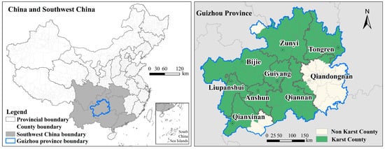
Figure 1.
Geographical location of karst areas in Guizhou, Southwest China.
2.2. Construction of Index System
Based on the characteristics of the karst [33,34], and the availability and representatives of evaluation indicators, this study establishes an indicator system for ecological, production, and social functions (Table 1). Ecological functions refer to the ability of a specific region to provide ecological services to its residents, respond to external disturbances, achieve self-repair, and maintain ecosystem stability. As rural production capacity increases, the scope and intensity of agricultural activities expand, leading to the degradation of ecological functions. To measure this, the fertilizer input intensity is chosen as an indicator to represent the ecological purification function, reflecting the ecological behavior of farmers in different regions [8]; this is a negative indicator, wherein higher values indicate weaker regional ecological functions. Furthermore, given the fragile ecological environment of karst areas, inappropriate human cultivation activities lead to forest vegetation degradation. Consequently, the proportion of slope farmland is selected as another negative indicator. In addition, forests and grasslands are crucial for maintaining biodiversity in karst areas. Considering the availability of indicators, this study uses the proportion of forest and grassland areas, based on land-use data, as positive indicators representing ecological functions; higher values indicate stronger regional ecological functions. The production function aims to assess the ability of residents in karst areas to produce food and increase social wealth. For this purpose, this study selects indicators from both agricultural and non-agricultural production functions. Specifically, the per capita agricultural production land area and per capita grain output are chosen to represent agricultural production functions. Meanwhile, the GDP contribution ratio of secondary and tertiary industries, as well as the number of non-agricultural employed persons in rural areas, are selected to represent non-agricultural production functions. Notably, all the selected production function indicators are positive, with higher values indicating stronger production functions. The social function aims to reflect the living conditions and well-being of residents in karst areas. The per capita net income of residents indicates income levels, while the per capita rural housing land area demonstrates the system’s ability to provide living environments. Given the small scale of primary school students in impoverished areas [35] and the fact that karst regions were once among the poorest in China, the number of primary school students is chosen as an indicator reflecting the educational-guarantee level within the social function in karst areas. Additionally, the number of hospital beds per 10,000 people and the per capita social investment indicate the levels of social welfare and medical security.

Table 1.
The index system and weight of ecological, production, and social functions.
2.3. Measurement of Three Functions
This study employs a comprehensive evaluation method to measure the production, social, and ecological functions. In particular, to standardize the indicators, the range standardization method is adopted, effectively mitigating disparities among data from diverse sources [36,37]. Additionally, the weights of the indicators are calculated using the entropy weight method, which objectively quantifies the informational value of each indicator and minimizes the potential influence of subjective biases on the evaluation outcomes [38]. This method has been widely applied and is highly regarded in regional studies [29]. The calculation formulas are presented as follows:
where, r and w represent the standardized value and weight, respectively. f(e), f(p), and f(s) are the regional ecological function, production function, and social function index, respectively. f(c) is the comprehensive function index, with a value between 0 and 1, the larger the value of f(e), f(p), f(s), and f(c), the stronger the versatility of the county, and vice versa.
2.4. Dynamic Evolution of Spatial Pattern
2.4.1. Kernel Density Estimation Model
Kernel Density Estimation (KDE) is a spatial density analysis method based on a data density function clustering algorithm. It analyzes the focus intensity and spatial continuity distribution of observed objects by calculating the density of observed data within a certain range around any point in space. This study employs the KDE model to measure the continuity and differentiation characteristics of the spatial distribution of comprehensive function index. The expression of KDE is as follows:
where is the estimated density at point ; is the number of observations; is the bandwidth (smoothing parameter); indicates the distance from county to county within the range ; and is the number of counties within the study area.
2.4.2. Standard Deviation Ellipse Model
Standard deviation ellipse (SDE) is a spatial statistical analysis method used to reflect the spatiotemporal evolution of research subjects and express the relative movement trajectories of geographic features. This study employs the SDE model to quantitatively describe the basic parameters of each function, including the center, major and minor axes, and rotation angle of the standard deviation ellipse. It quantitatively illustrates the spatial distribution direction, density, and dynamic changes in ecological, production, and social functions in karst areas from 2000 to 2020. This method was implemented using ArcGIS 10.6.
2.5. Identification of Dominant and Combined Functions
The dominant function of each county is determined based on the results of calculations involving ecological, production, and social functions, with the highest value among these three functions being selected as the dominant function type [39]. Combined functions are identified by assigning scores to ecological, production, and social functions, and then performing combinations. The specific process is as follows: First, the standard deviation classification method is used to determine the high values of the sub-function indices as the primary dimensions. This refers to a comprehensive value of a certain dimension that is greater than or equal to the mean of that dimension plus 0.5 times the standard deviation [40]. Next, each research unit is coded, with high values of the selected sub-function indices being assigned a value of 1, and others being assigned a value of 0. Each county is given a three-character code representing the combined functions: for example, 000 indicates a lagging development type, 111 indicates a comprehensive development type with high indices in ecological, production and social functions, 100 indicates an ecological-oriented type, 010 indicates a production-oriented type, and 001 indicates a social-oriented type (Table 2).
Table 2.
Combined function types.
2.6. Coordination of Three Functions
The interaction and competition among ecological, production, and social functions underscore the overlapping and diversified development needs within the county. Essentially, this dynamic development process involves the redistribution of scarce land and social resources both quantitatively and spatially among the three functions, highlighting different stages of socio-economic transformation. Ecological functions serve as the foundation of regional development, providing critical support for the realization of production and social functions. Production functions constitute the primary foundation for regional development, offering economic and material support for the execution of social functions. However, with the expansion and intensification of agricultural production activities, the destruction of the county’s ecological environment has become increasingly severe, leading to the weakening and decline of ecological functions. Social functions, while meeting residents’ daily living and interaction needs, also complement production functions. Yet, as residents’ income levels rise and social spaces expand, excessive human activities generate living pollution, exerting ecological pressure and impeding the realization of county-level ecological functions. There exists a synergistic and interactive relationship among ecological, production, and social functions characterized by mutual promotion and constraint. This study employs a coupling coordination model to measure the coordination degree among sub-functions. This model has been widely applied to relationships among subsystems and can effectively evaluate the coordination level and evolutionary characteristics of the sub-functions.
where C(x) represents the degree of coupling; D(x) denotes the degree of coordination. A higher D(x) value indicates a stronger overall coordination and a stronger connection between the sub-functions. The coordination degree is calculated and categorized into 5 types: severe non-coordination (0–0.2], mild non-coordination (0.2–0.4], primary coordination (0.4–0.5], intermediate coordination (0.5–0.8], and good coordination (0.8–1].
2.7. Data Sources
The administrative division and land-use data with a 30 m spatial resolution were obtained from the Resource and Environment Data Cloud Platform of the Chinese Academy of Sciences Resource and Environment Science Data Center [41]. Elevation and slope data were derived from the 30 m spatial resolution regional digital elevation model (DEM) data provided by the Guizhou Provincial Department of Natural Resources. The socio-economic data were sourced from the Guizhou Agricultural Statistical Yearbook, Guizhou Statistical Yearbook, Guizhou Regional Statistical Yearbook, and China County Statistical Yearbook (County Volume) (2000/2010/2020).
3. Results
3.1. Change in the Three Functions
Based on the ArcGIS 10.6 software platform, this study conducted a spatial visualization analysis of the ecological, production, and social functions in karst areas of Guizhou Province. The natural breaks classification method was employed to categorize these values, ensuring consistent classification standards for the same function across different periods. The results indicate that from 2000 to 2020, all three of the function index types in karst areas of Guizhou exhibited an annual growth trend (Figure 2). Specifically, over the 20 years, the proportion of low ecological function counties decreased by 35.1%, the proportion of low-mid increased by 1.4%, the proportion of mid increased by 19%, the proportion of mid-high increased by 12.2%, and the proportion of high increased by 2.1%. Spatially, the high ecological function counties were distributed in Luodian, Qingzhen, and Yuqing Counties, while the low were found in Danzhai, Hezhang, and Qixingguan districts. In 2000, all counties had low and low-mid production functions, with 85.1% of the counties classified as having low production function. By 2020, 55.4% of the counties had a mid-high production function, with a low production function accounting for 0%. Spatially, the counties with a high production function were mainly distributed in Daozhen, Dejiang, Fenggang, Kaiyang, Libo, Pingtang, Qixingguan, Suiyang, Tongzi, Wuchuan, Zhengan, and Zunyi Counties. Social function in 2000 was primarily characterized by low social function, which shifted to mid-high social function by 2020. Specifically, over the 20-year period, the proportion of low social function decreased by 71.6%, the proportion of low-mid social function decreased by 18.9%, the number of counties with mid social function remained unchanged, the proportion of mid-high social function increased by 63.5%, and the proportion of high social function increased by 27.0%. Spatially, counties with high social function were mainly distributed in Guiyang and Liupanshui Cities. The comprehensive function in 2000 was primarily characterized by low comprehensive function, which shifted to mid-high comprehensive function by 2020. Specifically, over the 20-year period, the proportion of low comprehensive function decreased by 62.2%, the proportion of low-mid comprehensive function decreased by 31.1%, the proportion of mid comprehensive function increased by 1.4%, the proportion of mid-high comprehensive function increased by 58.1%, and the proportion of high comprehensive function increased by 33.8%. Spatially, counties with high comprehensive function were mainly distributed in Guiyang and its surrounding counties.
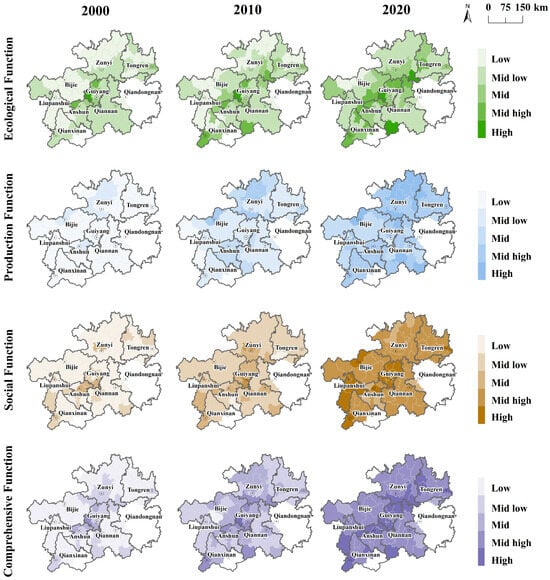
Figure 2.
Spatial-temporal change in ecological, production, social, and comprehensive functions in the Guizhou karst area from 2000 to 2020. Notes: The natural breaks method was applied to categorize the functional values of counties from 2000 to 2020 into five levels. Ecological function: low [0, 0.159), mid-low [0.159, 0.246), mid [0.246, 0.371), mid-high [0.371, 0.534), high [0.534, 0.887). Production function: low [0, 0.116), mid-low [0.116, 0.189), mid [0.189, 0.278), mid-high [0.278, 0.388), high [0.388, 0.732). Social function: low [0, 0.075), mid-low [0.075, 0.142), mid [0.142, 0.242), mid-high [0.242, 0.407), high [0.407, 0.720). Comprehensive function: low [0, 0.350), mid-low [0.350, 0.503), mid [0.503, 0.721), mid-high [0.721, 1.020), high [1.020, 1.583).
The analysis of the kernel density maps of comprehensive function reveals that, despite the consistent annual increase in the comprehensive function index across counties, the spatial kernel density exhibited a distinct pattern of multi-core expansion and contraction over time (Figure 3). In 2000, the region entered the stage of multi-core formation and development, characterized by relatively low integrated function values and the emergence of both high-density and low-density cores. The high-density core was centered in Guiyang, the provincial capital, while mid-high density and mid-low density zones formed around Guiyang. Furthermore, a mid-low density core emerged in the southwestern part of Tongren City. By 2010, the region transitioned into a stage of multi-core expansion. The mid-high density zone centered on Guiyang expanded further, extending its influence across the province. The core in the southwestern part of Tongren increased to mid-high levels, while mid-low density core also emerged in Liupanshui City and Qiannan Prefecture. In 2020, the region entered a stage of multi-core contraction. The core centered on Guiyang began to shrink, and the cores in Tongren City and Liupanshui City also declined to varying degrees. This shift indicates a trend toward a more balanced spatial distribution of integrated functions within the karst region. The previously highly concentrated high-density areas of comprehensive function exhibited reduced intensity, signifying a gradual move toward more equitable regional development.
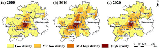
Figure 3.
Kernel density distribution of comprehensive function index in the Guizhou karst area from 2000 to 2020.
Standard deviation ellipse (SDE) analysis was conducted to examine the directional distribution and spatial migration of the ecological, production, social, and comprehensive functions, revealing their dynamic evolution (Figure 4). Specifically, the SDE for the ecological function shifted westward, with its area expanding from 59,615.89 km2 in 2000 to 60,349.28 km² in 2010, before contracting to 59,794.91 km2 in 2020, indicating an initial expansion followed by a contraction. The centroid of the ecological SDE was located in Baiyun and Xiuwen County of Guiyang City, moving southwest from 2000 to 2010 and then southeast from 2010 to 2020. In contrast, the SDE for the production function shifted northeastward, with its area expanding from 66,446.06 km2 in 2000 to 68,891.48 km2 in 2010, and further to 69,957.71 km2 in 2020, indicating a consistent expansion in the production function. The centroid of the production SDE was located in Xiuwen County of Guiyang City, moving northeast from 2000 to 2020. Similarly, the SDE for the social function shifted northwestward, with its area expanding from 58,194.35 km2 in 2000 to 59,226.54 km2 in 2010 and further to 62,788.35 km2 in 2020, indicating an expansion in social function. The centroid of the social SDE was located in Baiyun District and Xiuwen County of Guiyang City, moving northwest from 2000 to 2010 and then southwest from 2010 to 2020. Finally, the SDE for comprehensive functions shifted northeastward, with its area expanding from 61,413.45 km2 in 2000 to 63,336.38 km2 in 2010, and further to 64,708.92 km2 in 2020, indicating an expansion in comprehensive function. The centroid of the comprehensive SDE was located in Xiuwen County of Guiyang City, moving northwest from 2000 to 2010 and then northeast from 2010 to 2020.
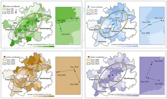
Figure 4.
Standard deviation elliptic distribution of ecological, production, and social functions in the Guizhou karst area from 2000 to 2020.
3.2. Change in the Dominant and Combined Functions
From 2000 to 2020, the dominant functions in karst areas of Guizhou underwent significant changes (Figure 5). In 2000, counties dominated by the production function accounted for 8.5%, those dominated by the social function accounted for 1.4%, and those dominated by the ecological function accounted for 90.1%. This indicates that during this period, the ecological environment in karst areas of Guizhou was favorable, but the production capacity and social welfare levels were relatively low. By 2020, the production capacity and social welfare levels in karst areas had improved significantly, with a more balanced distribution of dominant functions: counties dominated by the production function accounted for 39.4%, those dominated by the social function accounted for 39.4%, and those dominated by the ecological function accounted for 21.1%. Specifically, counties dominated by the production function increased from 8.5% in 2000 to 30.9% in 2015, and further to 39.4% in 2020, indicating that the period from 2000 to 2015 was marked by a significant increase in the production function. Similarly, counties dominated by the social function increased from 1.4% in 2000 to 9.9% in 2015, and further to 39.4% in 2020, indicating that the period from 2015 to 2020 was marked by a significant increase in social function.
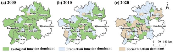
Figure 5.
Distribution of the dominant functions in the Guizhou karst area from 2000 to 2020.
Figure 6 illustrates the proportional distribution of combined functions in the Guizhou karst area from 2000 to 2020, highlighting notable changes across various categories. The lagged development type saw a consistent decline, decreasing from 47.2% in 2000 to 45.8% in 2010, and further to 40.3% in 2020, suggesting gradual improvements in regional development. Within the single function type, the ecological-oriented subcategory remained relatively stable, rising slightly from 5.6% in 2000 to 6.9% in 2010, before returning to 5.6% in 2020. The production-oriented subcategory exhibited a U-shaped pattern, decreasing from 22.2% in 2000 to 13.9% in 2010, then rebounding to 19.4% in 2020, potentially reflecting shifts in production strategies. Meanwhile, the social-oriented subcategory consistently increased, from 12.5% in 2000 to 18.1% in 2010, and stabilized at this level in 2020, signaling a growing emphasis on social functions. In the compound function type, the ecological–production subcategory demonstrated significant growth, remaining at 1.4% in both 2000 and 2010, but rising to 5.6% by 2020, indicating a stronger integration of ecological and production functions. The ecological–social subcategory initially grew from 4.2% in 2000 to 8.3% in 2010, but then dropped back to 4.2% in 2020. The production–social subcategory showed a continuous decline, from 5.6% in 2000 to 2.8% in 2020. Finally, the comprehensive function type (production–social–ecological) remained low but increased from 1.4% in 2000 and 2010 to 4.2% in 2020. Overall, these trends reflect a shift towards more integrated and multifunctional functions, with an increasing focus on the synergy between ecological, production, and social aspects, though challenges remain in achieving balanced development across all areas. However, counties classified as the lagged development type remained the most prevalent type throughout the period.
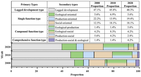
Figure 6.
Summary of combined functions in the Guizhou karst area from 2000 to 2020.
The spatial distribution of different types of counties clearly reflects the disparities and imbalances in regional development patterns (Figure 7). Counties classified as the lagged development type are predominantly concentrated in Bijie, Qianxinan, Qiannan, and Tongren, indicating that these areas still face significant challenges in sustainable development, with severe issues of regional imbalance and insufficient progress. Counties with the comprehensive function type, considered the ideal state for regional development, are extremely rare. In 2000 and 2010, Pingba was classified as a comprehensive function county. By 2020, Qingzhen, Kaiyang, and Wengan County fell into this category, signifying the notable advantage of suburban areas in coordinating ecological, production, and social functions during this period. These counties have become a model for balanced functional development, driven by urban influence and industrial integration. Counties with the single function type are widely distributed. Production-oriented counties are primarily concentrated in Zunyi, an area with favorable land conditions and abundant agricultural resources, making it a key region for agricultural production. In contrast, social-oriented counties are relatively few and are mainly located in Liupanshui and Guiyang. Ecological–production counties are distributed in Luodian, Pingba, Sinan, and Yuqing. These counties have gradually explored paths for synergistic development of ecology and production through ecological agriculture and sustainable resource use. Overall, the spatial distribution of combined functions types in the Guizhou karst area reflects a diverse pattern of ecological, economic, and social development within the region. Moving forward, policy design should be further optimized to strengthen targeted guidance and resource allocation for different county types, thereby enhancing sustainable development across the entire region.
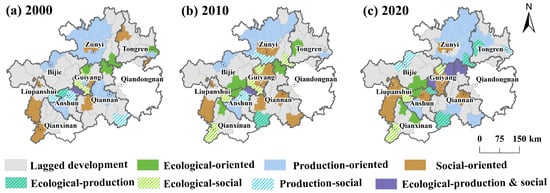
Figure 7.
Distribution of the combined functions in the Guizhou karst area from 2000 to 2020.
3.3. Change in the Coordination
From 2000 to 2020, the coordination levels between the ecological, production, and social functions in the Guizhou karst region significantly improved, rising from 0.31 to 0.55. This transition marks a shift from mid non-coordination to intermediate coordination. However, despite these improvements, the overall coordination level remains relatively low. In 2000, only Nameng, Yunyan, Wudang, Huaxi, and Qingzhen in Guiyang City, as well as Pingba County in Anshun City, exhibited primary coordination levels. This reflects the higher coordination level in central Guizhou during the early period. Throughout the study period, the areas surrounding Guiyang experienced a rapid increase in coordination, with the central region emerging as a significantly advantageous area for multifunctional coordination (Figure 8). By 2020, only Hezhang County in Bijie City, Puan County in Qianxinan City, Ziyun County in Anshun City, Sandu County in Qiannan City, and Majiang, Danzhai, and Cengong Counties in Qiandongnan City, as well as Zhongshan District in Liupanshui City, showed low coordination levels, classified as primary coordination.
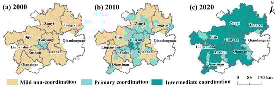
Figure 8.
Spatial-temporal evolution of the function’s coordination in the Guizhou karst area from 2000 to 2020.
From 2000 to 2020, the degree of coordination among the sub-functions steadily increased. The coordination between ecological, production, and social functions transitioned from non-coordination to coordination. Specifically, the coordination between ecological and production functions shifted from non-coordination to coordination by 2010, while the coordination between ecological and social functions, as well as production and social functions, transitioned in 2020 (Figure 9). This indicates that between 2000 and 2010, improvements in the ecological benefits were most evident, with the karst ecological restoration efforts promoting coordinated development between ecological and production functions. From 2010 to 2020, the enhancement of social welfare became increasingly prominent, as the coordination between ecological and production functions evolved from basic coordination to primary coordination, while the coupling and coordination levels between ecological and social functions, and production and social functions, shifted from non-coordination to coordination.
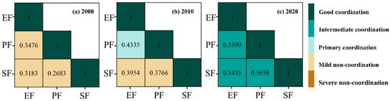
Figure 9.
Coordinated evolution of sub-functions in the Guizhou karst area from 2000 to 2020. Notes: EF (ecological function); PF (production function); SF (social function).
4. Discussion
4.1. Coordination Mechanism of Production–Social–Ecological Functions in Karst Area
From 2000 to 2020, there were significant improvements in the functions of the Guizhou karst area, notably in production and social functions. In 2000, the dominant function in most counties was the ecological function. From 2000 to 2010, the production function improved significantly, becoming the dominant function in most counties. Between 2010 and 2020, the social function saw marked improvements and became the dominant function in most counties. Additionally, the relationships among these functions have also seen notable enhancements. In 2000, the interactions between ecological, production, and social functions were characterized by non-coordination. By 2010, the relationship between ecological function and production function had transitioned to a coordinated state, and by 2020, all three functions—ecological, production, and social—were in a state of coordination. This evolutionary trajectory indicates that the coordination of the three functions in karst areas is a gradual, cumulative process. Improvements in the relationships between different functions exhibit phased characteristics. Consequently, it is inferred that, over time, the relationships among functions in the karst areas of Guizhou will become more coordinated, leading to more sustainable regional development [42].
Guizhou is a key region for poverty alleviation and ecological restoration in China. The Chinese government has invested substantial resources in ecological restoration and protection and has addressed the large-scale rural poverty issue in the region through targeted poverty alleviation programs. Moreover, as the urbanization process in Guizhou accelerates, an increasing number of rural inhabitants are migrating to cities for work, effectively boosting residents’ incomes. Specifically, in terms of improving ecological functions, the region has effectively restored vegetation through initiatives such as mountain closure for afforestation and the conversion of cropland back to forests and grasslands, significantly enhancing the area’s carbon sequestration potential. Furthermore, the karst area has developed an eco-friendly community management system through ecological migration, which protects the environment while also considering residents’ well-being [43]. Regarding the enhancement of production functions, to prevent land degradation, farmlands susceptible to karst processes have been converted to forests and grasslands and integrated with the development of agroforestry [44]. This approach not only prevents soil erosion but also balances ecological protection with the livelihood transformation of farmers [45]. In terms of improving social functions, the implementation of targeted poverty alleviation policies has significantly improved residents’ welfare in housing, healthcare, and education [46]. Encouraging residents to seek employment in urban areas has effectively increased their incomes. Overall, by enhancing social welfare to improve living functions, developing the economy to enhance production functions, and restoring ecosystems to improve ecological functions, the karst region has integrated environmental improvement with socio-economic development. This approach adjusts the industrial structure and develops a three-dimensional economy based on local natural resource-carrying capacity, leading to a gradual state of coordination in karst areas (Figure 10). In conclusion, national efforts in ecological restoration, poverty alleviation, and urbanization are the key driving forces behind the transformation of ecological, production, and social functions in the karst region. These measures not only enhance the development levels of the ecological, production, and social functions in the region but also optimize the relationships between these functions, promoting sustainable regional development.
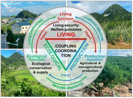
Figure 10.
Coordinated mechanism of ecological, production, and social functions.
4.2. Policy Implications
This study provides crucial scientific evidence for formulating sustainable development strategies in the karst area. In Guizhou, the spatial pattern of high-value comprehensive function areas is notably centered around the provincial capital, Guiyang, and extends towards the northeastern and southwestern parts of Guizhou. These high-value areas exhibit higher levels of urbanization and are primarily dominated by social and ecological functions. This indicates that although the agricultural production space in karst areas is limited, this limitation creates opportunities for the development of rural tourism, leisure agriculture, and agricultural product processing industries [47,48]. Moreover, the ecology-based regional development strategy presents new opportunities and solutions for karst areas [49]. To further enhance the coordination of ecological, productive, and social functions in karst areas, it is essential to optimize the diversified agricultural production layout characteristics of Guizhou karst areas. This involves planning the central city of Guiyang and its surrounding counties as metropolitan leisure agricultural zones, designating Zunyi City in the north as the primary traditional agricultural production area, and the western Qianxinan Prefecture as an ecological characteristic agricultural zone. Simultaneously, it is crucial to strengthen the spatial support for rural characteristic industries, infrastructure, and public service facilities. Furthermore, the spatial clustering effect of various functional levels in Guizhou’s karst area is diminishing, indicating a gradual reduction in regional development disparities. Nevertheless, future efforts should continue to implement differentiated management based on regional functional characteristics, with a focus on strengthening these characteristic functions in the formulation of relevant supporting policies. Additionally, from 2000 to 2010, there was a significant improvement in production functions in most areas, which became the dominant functions. From 2010 to 2020, social functions improved significantly and became the dominant functions in most counties. Given the constraints of the karst topography, which include natural geographic barriers and limited land-use conditions, most counties in Guizhou remain underdeveloped and lack competitive advantages. Future efforts should guide the formation of various group-based spaces, such as urban agglomerations, metropolitan areas, cluster cities, and village clusters. Enhancing interconnectivity among characteristic functional groups, promoting collaborative construction and sharing between adjacent counties, and improving the overall efficiency of spatial resource aggregation are crucial.
4.3. Limitations
Due to limitations in data availability, some aspects related to tourism and cultural functions in karst areas lack quantitative descriptions, which means the findings might not fully capture the evolution of functions in the karst region. Therefore, future research could explore the functional evolution of karst areas through specific development case studies. Moreover, the regional functions in China evolve with changes in policy orientation and urbanization processes, representing a complex and dynamic progression. Under large-scale ecological restoration efforts, the modes of human interference in the South China Karst area have significantly changed, transitioning from a state of tension to equilibrium in human–land relationships. Thus, future studies should focus on the processes and mechanisms through which ecological restoration promotes functional transformation in karst areas, as this will aid in advancing sustainable development in ecologically fragile zones [50,51].
5. Conclusions
This study employs comprehensive evaluation methods, standard deviation classification, and coordination models to analyze the spatiotemporal changes in regional functions of karst areas from 2000 to 2020. The results indicate that over the 20-year period, the ecological, production, and social functions in karst areas have exhibited an annual growth trend. Spatially, the year 2000 marked the stage of single-core formation and development. By 2010, this had progressed to a stage of single-core expansion and the emergence of multiple cores. By 2020, the region had entered a stage of single-core contraction, with a gradual decrease in the density of high-value comprehensive function areas, leading to more balanced regional development. The standard deviation ellipse for ecological functions shifted westward, while the standard deviation ellipse for production functions moved northeastward, and for social functions, it shifted northwestward. The standard deviation ellipse for comprehensive functions also moved northeastward as well. Notably, only the standard deviation ellipse area for ecological functions initially expanded and then contracted, whereas the standard deviation ellipses for production, social, and comprehensive functions all exhibited a trend of annual expansion. This suggests that over the past 20 years, there has been a spatially continuous divergence trend in the production and social functions in Guizhou’s karst areas, whereas the ecological functions have initially diverged and then contracted.
From 2000 to 2020, the dominant functions in the Guizhou karst area underwent significant changes, with the ecological function being dominant in 2000, the production function becoming dominant in 2010, and the social function taking the lead in 2020. Examining the changes in the number of dominant function types, the period from 2000 to 2015 saw a significant increase in production function, while from 2015 to 2020, there was a notable rise in social function. Regarding combined functions over the 20-year period, the lagged development type, production-dominant type, and production–social type exhibited a decreasing trend, although the lagged development type remained predominant overall. Spatially, the regions of Bijie, Qianxinan, Qiannan, and Tongren City had a high concentration of counties classified as lagged development types. In contrast, the areas surrounding Guiyang City exhibited a higher distribution of comprehensive function types. Among single-function types, production-dominant counties were more numerous, primarily concentrated in Zunyi City. It is essential to further elevate Guiyang as the leading central city in Guizhou, continuously enhance Zunyi City’s industrial support capabilities, and fully utilize the population aggregation potential of counties with lagging development types. Finally, efforts should focus on cultivating a multi-center, multi-level, multi-node networked urban agglomeration to promote the integration of ecological, productive, and social functions.
From 2000 to 2020, the coordination levels among the ecological, production, and social functions in the Guizhou karst area improved significantly, rising from 0.31 to 0.55. The coordination type shifted from mid non-coordination to intermediate coordination. Spatially, the central region of Guizhou demonstrated a clear advantage in multifunctional coordination. Examining the coordination levels between sub-functions, the relationship between ecological and production functions transitioned from non-coordination to coordination in 2010. Similarly, the coordination between ecological and social functions, as well as between production and social functions, transformed in 2020. This indicates that the coordination among the three functions in karst areas is a gradual and cumulative process, with the improvement in relationships between different functions exhibiting a phased characteristic. Guizhou serves as an important ecological barrier and a supply base for mountain-featured agricultural products. It is necessary to further enhance the level of urban–rural integration development, utilizing key cities such as Guiyang and Zunyi as nodes, to promote the formation of a networked functional structure with organic interactions among ecological, production, and social functions.
Author Contributions
Conceptualization, R.Z. and K.X.; methodology, R.Z. and A.L.; software, Q.C.; validation, A.L., Z.L., F.F. and N.Y.; formal analysis, R.Z.; investigation, R.Z.; resources, Q.C.; data curation, R.Z.; writing—original draft preparation, R.Z.; writing—review and editing, K.X.; visualization, R.Z.; supervision, Z.L.; project administration, K.X.; funding acquisition, K.X. All authors have read and agreed to the published version of the manuscript.
Funding
This research was funded by the Philosophy and Social Science Planning Key Project of Guizhou Province, China (21GZZB43), the Key Science and Technology Program of Guizhou Province (No. 5411 2017 QKHPTRC), and the China Overseas Expertise Introduction Project for Discipline Innovation (No. D17016).
Data Availability Statement
Data will be made available on request due to privacy.
Conflicts of Interest
The authors declare no conflicts of interest.
References
- Ford, D.C.; Williams, P. Karst Hydrogeology and Geomorphology; John Wiley & Sons Ltd.: West Sussex, UK, 2007; p. 576. [Google Scholar]
- Li, Y.; Ke, Q.; Zhang, Z. Millennial Evolution of a Karst Socio-Ecological System: A Case Study of Guizhou Province, Southwest China. Int. J. Environ. Res. Public Health 2022, 19, 15151. [Google Scholar] [CrossRef] [PubMed]
- Yue, Y.; Wang, L.; Brandt, M.; Zhang, X.; Wang, K. A social-ecological framework to enhance sustainable reforestation under geological constraints. Earth’s Future 2024, 12, e2023EF004335. [Google Scholar] [CrossRef]
- Ouyang, N.; Rui, X.; Zhang, X.; Tang, H.; Xie, Y. Spatiotemporal evolution of ecosystem health and its driving factors in the southwestern karst regions of China. Ecol. Indic. 2024, 166, 112530. [Google Scholar] [CrossRef]
- Jiang, Z.; Lian, Y.; Qin, X. Rocky desertification in Southwest China: Impacts, causes, and restoration. Earth-Sci. Rev. 2014, 132, 1–12. [Google Scholar] [CrossRef]
- Qiu, S.; Peng, J.; Dong, J.; Wang, X.; Ding, Z.; Zhang, H.; Mao, Q.; Liu, H.; Quine, T.A.; Meersmans, J. Understanding the relationships between ecosystem services and associated social-ecological drivers in a karst region: A case study of Guizhou Province, China. Prog. Phys. Geogr. Earth Environ. 2020, 45, 98–114. [Google Scholar] [CrossRef]
- Jourde, H.; Wang, X. Advances, challenges and perspective in modelling the functioning of karst systems: A review. Environ. Earth Sci. 2023, 82, 396. [Google Scholar] [CrossRef]
- Yang, Y.; Bao, W.; Liu, Y. Coupling coordination analysis of rural production-living-ecological space in the Beijing-Tianjin-Hebei region. Ecol. Indic. 2020, 117, 106512. [Google Scholar] [CrossRef]
- Cao, Z.; Zhang, Z.; Zhang, K.; Wei, X.; Xiao, S.; Yang, Z. Identifying and estimating soil erosion and sedimentation in small karst watersheds using a composite fingerprint technique. Agric. Ecosyst. Environ. 2020, 294, 106881. [Google Scholar] [CrossRef]
- Liu, C.Q. Biogeochemical Processes and Cycling of the Nutrients in the Earth’s Surface: Nutrient Cycling in Soil and Plant System in Karstic Catchment, Southwest China; Science Press: Beijing, China, 2009; p. 618. [Google Scholar]
- Hu, Z.; Wang, S.; Bai, X.; Luo, G.; Li, Q.; Wu, L.; Yang, Y.; Tian, S.; Li, C.; Deng, Y. Changes in ecosystem service values in karst areas of China. Agric. Ecosyst. Environ. 2020, 301, 107026. [Google Scholar] [CrossRef]
- Tong, X.; Brandt, M.; Yue, Y.; Ciais, P.; Jepsen, M.R.; Penuelas, J.; Wigneron, J.; Xiao, X.; Song, X.; Horion, S.; et al. Forest management in southern China generates short term extensive carbon sequestration. Nature Commun. 2020, 11, 129. [Google Scholar] [CrossRef]
- Zhao, M.; Li, D.; Liu, Z.; Bao, Q.; Xia, F.; Yan, H.; Chen, B.; Hu, Y.; Cai, G.; Lang, R.; et al. Karst carbon sink mechanism and its contribution to carbon neutralization under land- use management. Sci. Total Environ. 2024, 937, 173381. [Google Scholar] [CrossRef] [PubMed]
- Xiong, K.; He, C.; Zhang, M.; Pu, J. A New Advance on the Improvement of Forest Ecosystem Functions in the Karst Desertification Control. Forests 2023, 14, 2115. [Google Scholar] [CrossRef]
- Boudet, F.; MacDonald, G.K.; Robinson, B.E.; Samberg, L.H. Rural-urban connectivity and agricultural land management across the Global South. Glob. Environ. Change 2020, 60, 101982. [Google Scholar] [CrossRef]
- Chen, Y.; Cheng, C.; Xiong, K.; Rong, L.; Zhang, S. Quantifying the biodiversity and ecosystem service outcomes of karst ecological restoration: A meta-analysis of South China Karst. Catena 2024, 245, 108278. [Google Scholar] [CrossRef]
- Yu, L.; Li, Y.; Luo, G.; Ge, G.; Zhang, H.; Tang, F.; Yu, M. Spatiotemporal evolution and driving mechanism of slope cultivated land in karst mountainous areas of Southwest China—A case study of Puding County, Guizhou Province. Land Degrad. Dev. 2024, 35, 568–585. [Google Scholar] [CrossRef]
- Deng, X.; Xiong, K.; Yu, Y.; Zhang, S.; Kong, L.; Zhang, Y. A Review of Ecosystem Service Trade-Offs/Synergies: Enlightenment for the Optimization of Forest Ecosystem Functions in Karst Desertification Control. Forests 2023, 14, 88. [Google Scholar] [CrossRef]
- Chen, Q.W.; Lu, S.X.; Xiong, K.N.; Zhao, R. Coupling analysis on ecological environment fragility and poverty in South China Karst. Environ. Res. 2021, 201, 111650. [Google Scholar] [CrossRef] [PubMed]
- Tang, J.; Xu, Y.; Ma, W.; Gao, S. Does participation in poverty alleviation programmes increase subjective well-being? Results from a survey of rural residents in Shanxi, China. Habitat Int. 2021, 118, 102455. [Google Scholar] [CrossRef]
- Cui, Z.; Li, E.; Li, Y.; Deng, Q.; Shahtahmassebi, A. The impact of poverty alleviation policies on rural economic resilience in impoverished areas: A case study of lankao county, China. J. Rural Stud. 2023, 99, 92–106. [Google Scholar] [CrossRef]
- Wei, B.; Mao, X.; Liu, S.; Liu, M.; Wang, Z.; Kang, P.; Gao, H.; Tang, W.; Feng, S.; Pan, Z. Breaking the poverty trap in an ecologically fragile region through ecological engineering: A close-up look at long-term changes in ecosystem services. J. Environ. Manag. 2024, 358, 120921. [Google Scholar] [CrossRef]
- Bu, Z.; Fu, J.; Jiang, D.; Lin, G. Production–Living–Ecological Spatial Function Identification and Pattern Analysis Based on Multi-Source Geographic Data and Machine Learning. Land 2023, 12, 2029. [Google Scholar] [CrossRef]
- Tan, N.; Chang, X.; Ma, T. Study on Production–Living–Ecological Function Accounting and Management in China. Land 2023, 12, 1163. [Google Scholar] [CrossRef]
- Dai, R.; Wang, C.; Wu, X. Path of Rural Sustainable Development Based on the Evolution and Interaction of Rural Functions: A Case Study of Chongqing Municipality, China. Chin. Geogr. Sci. 2022, 32, 1035–1051. [Google Scholar] [CrossRef]
- Xia, N.; Hai, W.; Tang, M.; Song, J.; Quan, W.; Zhang, B.; Ma, Y. Spatiotemporal evolution law and driving mechanism of production-living-ecological space from 2000 to 2020 in Xinjiang, China. Ecol. Indic. 2023, 154, 110807. [Google Scholar] [CrossRef]
- Ma, Y.; Ji, W.; Meng, Q.; Zhang, Y.; Li, L.; Liu, M.; Wei, H. Assessing Land Use Ecological-Social-Production Functions and Interrelationships from the Perspective of Multifunctional Landscape in a Transitional Zone between Qinghai-Tibet Plateau and Loess Plateau. Diversity 2024, 16, 618. [Google Scholar] [CrossRef]
- Qin, Y.; Wang, L.; Yu, M.; Meng, X.; Fan, Y.; Huang, Z.; Luo, E.; Pijanowski, B. The spatio-temporal evolution and transformation mode of human settlement quality from the perspective of “production-living-ecological” spaces—A case study of Jilin Province. Habitat Int. 2024, 145, 103021. [Google Scholar] [CrossRef]
- Long, H.; Ma, L.; Zhang, Y.; Qu, L. Multifunctional rural development in China: Pattern, process and mechanism. Habitat Int. 2022, 121, 102530. [Google Scholar] [CrossRef]
- Liu, F.; Wang, C.; Luo, M.; Zhou, S.; Liu, C. An investigation of the coupling coordination of a regional agricultural economics-ecology-society composite based on a data-driven approach. Ecol. Indic. 2022, 143, 109363. [Google Scholar] [CrossRef]
- Wang, X.; Liu, Y.; Shao, Y.; Li, S. Evolution pattern and mechanism of rural areal functions in Xi’an metropolitan area, China. Habitat Int. 2024, 148, 103088. [Google Scholar] [CrossRef]
- Xiong, K.N.; Li, P.; Zhou, Z.F.; An, Y.L.; Lyu, T.; Lan, A.J. The Typical Study on RS-GIS of Karst Desertification with a Special Reference to Guizhou Province, 3rd ed.; Geology Press: Beijing, China, 2002; pp. 97–98. [Google Scholar]
- Li, S.L.; Liu, C.Q.; Chen, J.A.; Wang, S.J. Karst ecosystem and environment: Characteristics, evolution processes, and sustainable development. Agric. Ecosyst. Environ. 2021, 306, 107–173. [Google Scholar] [CrossRef]
- Wang, K.; Zhang, C.; Chen, H.; Yue, Y.; Zhang, W.; Zhang, M.; Qi, X.; Fu, Z. Karst landscapes of China: Patterns, ecosystem processes and services. Landsc. Ecol. 2019, 34, 2743–2763. [Google Scholar] [CrossRef]
- Ingutia, R.; Rezitis, A.; Sumelius, J. Child poverty, status of rural women and education in sub–Saharan Africa. Child. Youth Serv. Rev. 2020, 111, 104869. [Google Scholar] [CrossRef]
- Hu, Q.; Wang, C. Quality evaluation and division of regional types of rural human settlements in China. Habitat Int. 2020, 105, 102278. [Google Scholar] [CrossRef]
- Wang, C.; Tang, L. Spatio-temporal characteristics and evolution of rural production living-ecological space function coupling coordination in Chongqing Municipality. Geogr. Res. 2018, 37, 1100–1114. [Google Scholar]
- Shannon, C.E. A mathematical theory of communication. Bell Syst. Tech. J. 1948, 27, 379–423. [Google Scholar] [CrossRef]
- Zou, L.; Liu, Y.; Yang, J.; Yang, S.; Wang, Y.; Cao, Z.; Hu, X. Quantitative identification and spatial analysis of land use ecological-production-living functions in rural areas on China’s southeast coast. Habitat Int. 2020, 100, 102182. [Google Scholar] [CrossRef]
- Liu, Y.; Liu, Y.; Chen, Y. Territorial multifunctionality evaluation and decision making mechanism at county scale in China. Acta Geogr. Sin. 2011, 66, 1379–1389. [Google Scholar]
- Xu, X.; Liu, J.; Zhang, S.; Zhang, S.; Li, R.; Yan, C.; Wu, S. China Multi-Period Land Use Remote Sensing Monitoring Dataset (CNLUCC). Resource and Environmental Science Data Registration and Publishing System. 2018. Available online: http://www.resdc.cn (accessed on 1 April 2023).
- Yang, L.; Li, Y.; Yu, L.; Chen, M.; Zhang, Y.; Ren, X. Characteristics of bare rocky land evolution in karst mountain areas of Southwest China based on socio-ecological system perspectives: The case study of Huajiang Canyon. Catena 2024, 242, 108–139. [Google Scholar] [CrossRef]
- Wang, K.; Yue, Y.; Ma, Z.; Lei, T.; Li, D.; Song, T. Research and demonstration on technologies for rocky desertification treatment and ecosystem services enhancement in karst peak cluster depression regions. Acta Ecol. Sin. 2016, 36, 7098–7102. [Google Scholar]
- Xiao, J.; Xiong, K.N. A review of agroforestry ecosystem services and its enlightenment on the ecosystem improvement of rocky desertification control. Sci. Total Environ. 2022, 856, 158538. [Google Scholar] [CrossRef] [PubMed]
- Yang, L.; Li, Y.; Yu, L.; Chen, M.; Yu, M.; Zhang, Y. Theory and case of land use transition promoting ecological restoration in karst mountain areas of Southwest China. Ecol. Indic. 2024, 158, 111393. [Google Scholar] [CrossRef]
- Liu, Y. Household livelihood choices under the different eco-environment in the karst area: A case study of Anshun City, southwest of China. Environ. Res. 2021, 197, 111171. [Google Scholar] [CrossRef]
- Qin, X.; Li, Y.; Lu, Z.; Pan, W. What makes better village economic development in traditional agricultural areas of China? Evidence from 338 villages. Habitat Int. 2020, 106, 102286. [Google Scholar] [CrossRef]
- Hu, X.; Li, H.; Zhang, X.; Chen, X.; Yuan, Y. Multi-dimensionality and the totality of rural spatial restructuring from the perspective of the rural space system: A case study of traditional villages in the ancient huizhou region, China. Habitat Int. 2019, 94, 102062. [Google Scholar] [CrossRef]
- Li, Y.; Wu, W.; Liu, Y. Land consolidation for rural sustainability in China: Practical reflections and policy implications. Land Use Policy 2018, 74, 137–141. [Google Scholar] [CrossRef]
- Fu, B.J. Coupling human and natural systems for sustainable development. Natl. Sci. Rev. 2023, 10, 86. [Google Scholar] [CrossRef] [PubMed]
- Tedesco, A.M.; López-Cubillos, S.; Chazdon, R.; Rhodes, J.R.; Archibald, C.L.; Pérez-Hämmerle, K.V.; Brancalion, P.H.S.; Wilson, K.A.; Oliveira, M.; Correa, D.F.; et al. Beyond ecology: Ecosystem restoration as a process for social-ecological transformation. Trends Ecol. Evol. 2023, 38, 643–653. [Google Scholar] [CrossRef] [PubMed]
Disclaimer/Publisher’s Note: The statements, opinions and data contained in all publications are solely those of the individual author(s) and contributor(s) and not of MDPI and/or the editor(s). MDPI and/or the editor(s) disclaim responsibility for any injury to people or property resulting from any ideas, methods, instructions or products referred to in the content. |
© 2025 by the authors. Licensee MDPI, Basel, Switzerland. This article is an open access article distributed under the terms and conditions of the Creative Commons Attribution (CC BY) license (https://creativecommons.org/licenses/by/4.0/).