Article

Novel Planning Strategies for Ecological Restoration of Abandoned Mines: A Case of Toli County, China

1
School of Geology and Mining Engineering, Xinjiang University, Urumqi 830046, China
2
China Geological Survey Turpan Project Department, Changji 838000, China
3
Xinjiang Uygur Autonomous Region Land Consolidation Center, Urumqi 830002, China
4
Xinjiang Green Blasting Engineering Technology Research Center, Changji 831100, China
5
Nan Open-Pit Coal Mine, Xinjiang Tianchi Energy Co., Ltd., Changji 831100, China
6
Seventh Geological Brigade of Xinjiang Bureau of Geology and Mineral Resources, Wusu 833000, China
*
Authors to whom correspondence should be addressed.
Land 2025, 14(12), 2317; https://doi.org/10.3390/land14122317
Submission received: 30 October 2025 / Revised: 21 November 2025 / Accepted: 21 November 2025 / Published: 25 November 2025

Abstract

With the development of mineral resources, the inevitable creation of numerous abandoned mines has impacted environmental resources. Numerous studies have been conducted on the restoration and management of individual abandoned mines. However, there has been no systematic study on the overall ecological restoration planning of abandoned mine clusters. Hence, there is an urgent need to research restoration planning strategies, focusing on the characteristics of abandoned mines and their environmental impacts. In this study, abandoned mines in Toli County, Xinjiang, were selected as the case. The K-means clustering analysis method was employed to study the spatial distribution of abandoned mines, selecting longitude, latitude, and road access as analytical factors. Based on spatial location attributes, three groups of abandoned mines were identified. The Analytic Hierarchy Process (AHP) was used to study the ecological importance evaluation model in Toli County, selecting eight evaluation factors including vegetation, precipitation, and population density, and dividing the ecological importance levels of various sectors to establish a three-stage restoration project. The Principal Component Analysis (PCA) method was used to assess the hazards of abandoned mines, selecting distance, land type, area, and ecological impact as influencing factors and determining the management sequence of abandoned mines within each project. The results show that (1) longitude, latitude, and road indices help to mitigate geographical obstacles such as mountains and rivers, ensuring a high degree of continuity in abandoned mine areas; (2) the AHP reveals that the combined weight of population density, gross domestic product, and vegetation index exceeds 80%, which are key factors affecting the priority of ecological restoration; and (3) the application of PCA provides a scientific basis for the hazard assessment and management of abandoned mines, prioritizing those close to densely populated areas and with larger areas. The significance of this study lies in providing a systematic method for ecological restoration planning of abandoned mines, as well as offering important references for future research and practice in related fields.

1. Introduction

China’s extensive mining history has resulted in a substantial number of abandoned mines. In the context of advancing ecological civilization, there is an imperative to enhance the management of these abandoned sites [1]. Projections indicate that by 2030, China will have approximately 15,000 abandoned mines, primarily non-metallic [2]. Despite this, the reclamation rate remains below 10%, leading to the degradation of over 3.61 million hectares of land resources. Furthermore, abandoned mines contribute to various geological and environmental challenges, including mine-related geological disasters and soil and water pollution [3,4]. Currently, China is intensifying its efforts to manage abandoned mines. However, ecological restoration efforts encounter significant obstacles due to the uneven spatial distribution of abandoned mines, intricate ecological issues [5], prolonged remediation timelines, and high associated costs [6]. These challenges are not unique to China, as international studies have similarly highlighted the difficulties in restoring ecosystems affected by mining activities [7,8]. Global research has focused on integrating both surface and subsurface restoration strategies, emphasizing the need for tailored approaches that account for regional environmental, socio-economic, and policy factors [9,10]. Consequently, there is an urgent need for research focused on developing effective ecological management and planning strategies [11] that can draw from both international best practices and the unique challenges faced by China’s mining regions.
To address the issue of ecological management planning for abandoned mines, various methods of governance and restoration of abandoned mines have been explored worldwide [12,13]. In response to the necessity of ecological restoration in mining areas, we studied the concept and current status of ecological restoration in mining areas, proposing a strategy and comprehensive technical system for ecological and environmental restoration in China’s mining areas [14]. Based on the necessity of restoration, we analyzed the effects of natural recovery and artificial intervention in land restoration in mining areas, identifying the main methods of land restoration in mining areas as pre-mining prevention and post-mining rehabilitation [15]. Regarding the ecological restoration in mining areas, we conducted a study on the ecological restoration strategies for abandoned mines, clarifying the overall approach and basic principles of ecological restoration of abandoned mines in China [16]. Meanwhile, foreign scholars have proposed the concept of using cemented paste to backfill and repair severely disturbed surfaces caused by complex iron ore mining [17]. Given the varying environmental conditions in the restoration process of abandoned mines [18], we proposed territorial spatial planning for mine ecological restoration, adopting a tailored approach to ecological restoration in different regions [19]. International research was also focused on the ecological restoration of individual or local abandoned mines. In particular, extensively studied the effect of surface vegetation on restoring mining areas to their pre-mining ecological state [20]. A comprehensive assessment framework for entire abandoned mine regions has been developed, exploring sustainable remediation strategies within the contexts of ecotourism and the circular economy [21]. Overall, restoration technologies for abandoned mines, whether on individual or small-scale regions, have demonstrated increasing maturity both domestically and internationally. In summary, the available technologies for restoring abandoned mines become increasingly mature [22]. Still, there is a lack of research on overall ecological restoration planning strategies for abandoned mines within particular regions and specific local conditions.
This study integrates the overall approach and requirements of ecological management planning for abandoned mines in China [23,24]. Utilizing such statistical analysis methods as cluster [25,26], hierarchical [27], and principal component analyses [28], An ecological restoration sequencing model for abandoned mines was developed through the collection of field data and the analysis of remote sensing data, it identifies feasible strategies for abandoned mine reclamation planning, facilitating the arrangement of a three-phase restoration project for abandoned mines in Toli County. Through the collection of field data and analysis of remote sensing data, an ecological restoration sequence planning model for abandoned mines was developed. This model identifies viable strategies for the reclamation planning of abandoned mines, thereby facilitating the implementation of a three-phase restoration project in Toli County. The study encompasses four primary objectives: (1) Dividing the abandoned mines into three contiguous and spatially concentrated regions based on spatial continuity and road accessibility, thereby reducing transportation and remediation costs in management projects; (2) Assessing the ecological significance of Toli County and categorizing the three regions into phased restoration projects to sequentially implement remediation efforts, prioritizing areas of high ecological importance; (3) Evaluating the hazards posed by abandoned mines during each project phase and determining the sequence of remediation activities to prioritize the treatment of mines that present significant threats to human safety; and (4) Completing the zoning, classification, and graded reclamation planning for abandoned mines in Toli County, establishing a restoration sequence for all abandoned mines, and providing a reference framework for planning in other similar locations and regions.

2. Methodology

2.1. Study Area

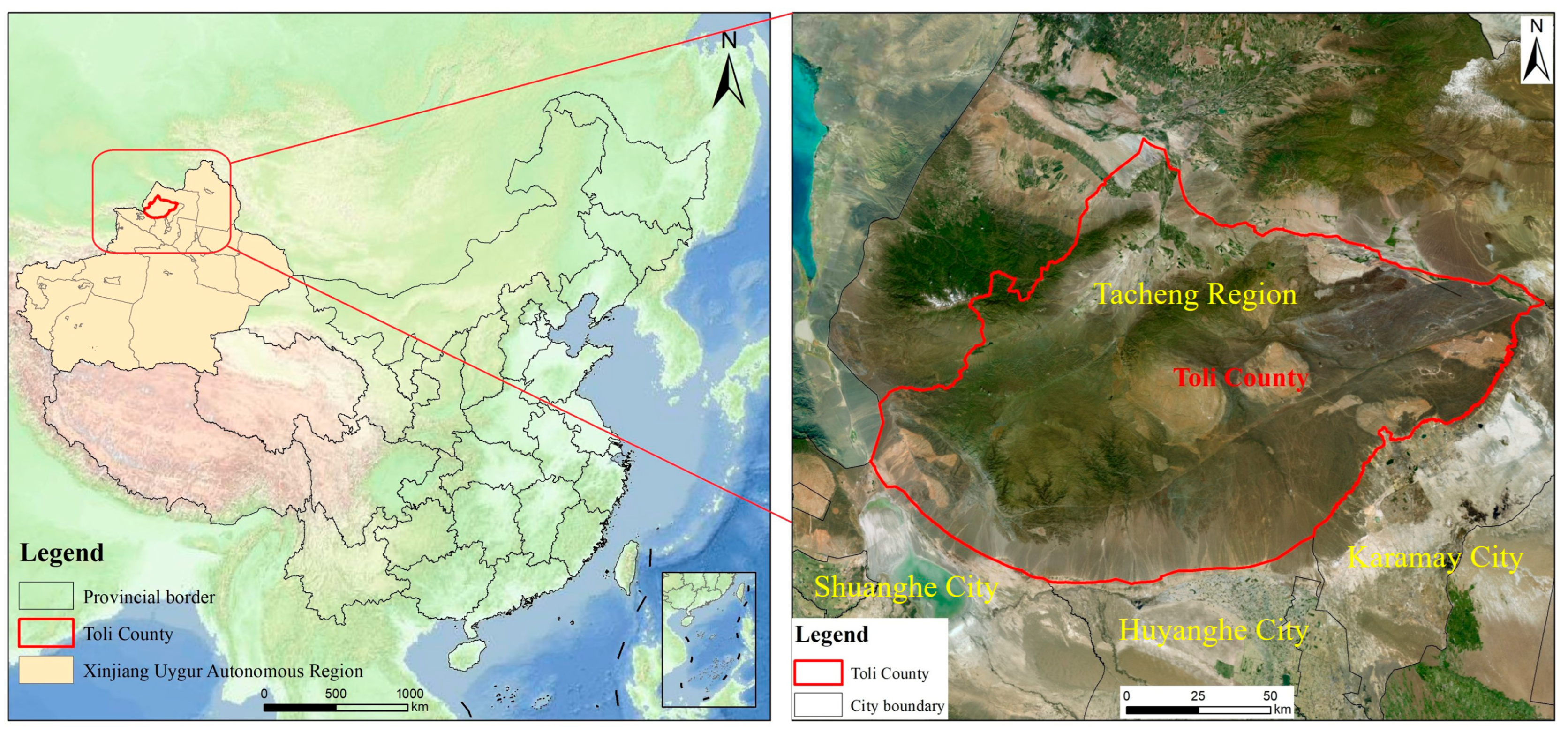
Toli County is located in the northwest of Xinjiang Uygur Autonomous Region, on the west side of the Junar Basin, in the southeast of the Tarim Basin, and in the geographical heart of the Eurasian continent and lies between 44°58′ and 46°24′ north latitude and 82°28′ and 85°20′ east longitude, with a border line of approximately 58 km. The county stretches 221.6 km from east to west and 159.3 km from north to south, covering a total area of 21,300 square kilometers km2 (Figure 1). The County has favorable conditions for mineralization and serves as an important mineral resource reserve base in Xinjiang. Long-term mining activities have resulted in numerous abandoned mines, with non-metallic, metal, and metalloid mines accounting for 84.1%, 13.5%, and 2.4%, respectively. The main types of land damaged by these activities are grasslands, croplands, and construction land. Consequently, the development of mineral resources in Toli County has triggered regional environmental problems, including vegetation die-off, land degradation, soil erosion, and air pollution. Therefore, there is an urgent need to carry out ecological restoration in mining areas, particularly for historically abandoned mines.

2.2. Data Source

To investigate the current situation of abandoned mines in Toli County, China, we conducted field surveys and analyzed remote sensing data. The study primarily involved the collection of data pertaining to abandoned mines in Toli County, including the number and types of mines, their spatial coordinates (latitude and longitude), distances from human settlements and transportation infrastructure, the area occupied by each abandoned mine, and the types of land degradation associated with them, The “General Plan for Territorial Space of Toli County (2023)” was selected for analysis to determine the socio-economic planning of Toli County. Relying on the “Mine geological environment protection and land reclamation plan” of typical mines in the county, a survey was conducted on the mines and surrounding environment in Toli County. To clarify the sources and generation methods of the subsequent indicator data, such as population density, slope, and aspect, population density data were sourced from national census databases, while slope and aspect were derived from DEM (Digital Elevation Model) data using GIS software, specifically ArcGIS 10.8.
Landsat 8 OLI images for 2024 were downloaded from NASA Earth Science Data and subjected to radiometric and atmospheric correction, mosaicking, and clipping to the boundary of Toli County. On this basis, land use information and the vegetation index spatial distribution were interpreted, and the Normalized Difference Vegetation Index (NDVI) was calculated using the red and near-infrared bands. The 30 m DEM data were used to derive elevation and related topographic variables. gross domestic product (GDP) and precipitation data were obtained from ready-made gridded spatial datasets provided by the Chinese Academy of Sciences and the National Earth System Science Data Center, respectively. These datasets were reprojected, resampled to ensure compatibility with the Landsat-based layers, and clipped to the study area, and were then integrated into the GIS for subsequent ecological evaluation. These datasets were utilized to evaluate and analyze the ecological environment of the county (Table 1).

2.3. Methods

The planning sequence for abandoned mines in Toli County is formulated by the requirements of ecological civilization construction, considering such factors as contiguity, ecological safety [32], and ecological functions for scheduling work phases [33]. A sequential restoration planning and design for abandoned mines in Toli County was undertaken.
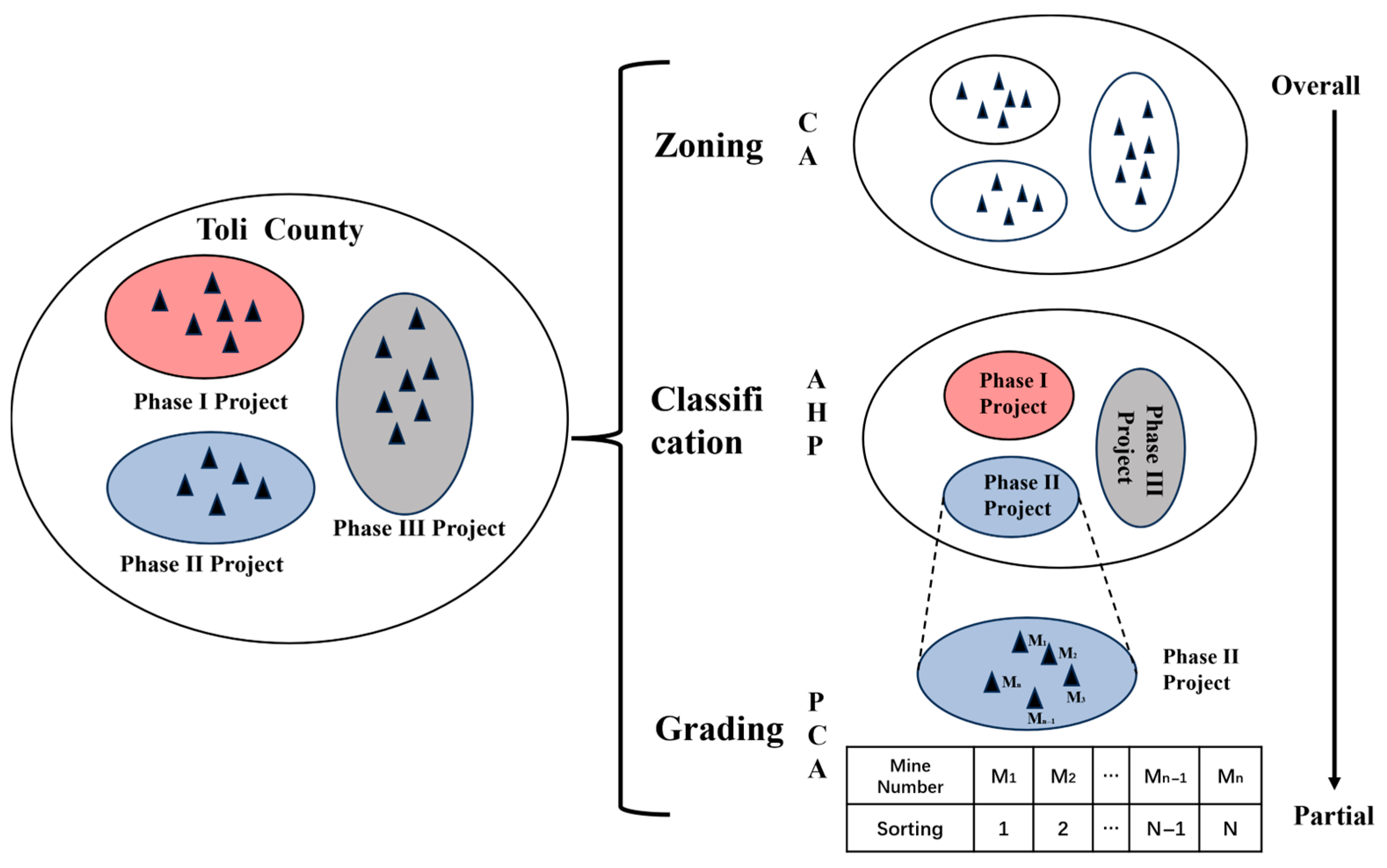
Initially, a zoning plan for the abandoned mines in Toli County was formulated based on the degree of contiguity, dividing the county into three abandoned mine zones to facilitate the arrangement of subsequent work phases. Furthermore, to establish the prioritization sequence for the remediation of three zones of abandoned mines, the ecological importance of Toli County was evaluated based on the extent of human impact. A classification scheme was developed for the three primary regions, prioritizing ecological restoration in areas of greater human significance, thereby delineating the first, second, and third phases of the abandoned mine management project. Subsequently, for each phase, the hazards posed by abandoned mines to human populations were assessed, and remediation efforts were prioritized for mines presenting the highest threats to human safety. This methodology ultimately determined the restoration sequence of abandoned mines within each phase. Ultimately, this achieved the research goal of studying the management planning of abandoned mines in Toli County (Figure 2).

2.3.1. Abandoned Mine Zoning Management Planning Methodology

The zoning criteria for abandoned mines aimed to delineate regions where the mines are contiguous and spatially concentrated. To facilitate this zoning planning, cluster analysis was employed [34]. Specifically, the K-means clustering method was selected due to its efficacy in classifying samples or indices and its ability to distinguish similar data points effectively. Consequently, a cluster analysis with K = 3 was implemented to define the zoning framework.
Three factors were selected for the clustering and zoning of abandoned mines: longitude, latitude, and road index [35]. Since the K-means cluster analysis method uses the distances between data points, large differences in the dimensions of different factors can lead to the clustering results being directly controlled by a few high-dimension variables. Therefore, to ensure the same data dimensions, it was necessary to standardize the factor data [36]. Standardization used the Z-Score function, calculating the difference between each data value and the average value of the dataset AVERAGE (range) and dividing it by the standard deviation STDEV (range). The calculation formula Equation (1) is as follows:
O = (AVERAGE (range) − value)/STDEV (range).
After standardizing the basic data of abandoned mines in Toli County, the K-means cluster analysis with K = 3 was performed. Initially, three cluster centers, M1, M2, and M3, were arbitrarily selected. The distance between each abandoned mine and the three cluster centers was calculated, and each abandoned mine was assigned to the group of the nearest cluster center, completing the first iteration of the analysis and resulting in three zones [37]. Then, the average values of the data in each zone were taken as the cluster centers for the second iteration, and the distances from each abandoned mine to these new cluster centers were calculated to obtain three zones, completing the second iteration. After five iterations of this cluster analysis, the calculations converged, the abandoned mines within each zone remained unchanged, and the clustering zoning was completed.

2.3.2. Management Planning Strategy for Abandoned Mine Classification

The above zoning plan was based on the contiguity degree and achieved zoning planning of abandoned mines but did not specify the management construction phases of each zone. This study used the analytic hierarchy process (AHP) [38], taking the degree of human activity impact as the analytical standard to evaluate the overall environment of Toli County [39,40]. Based on the zoning results, the first, second, and third phases of management projects for abandoned mines in Toli County were determined [41].
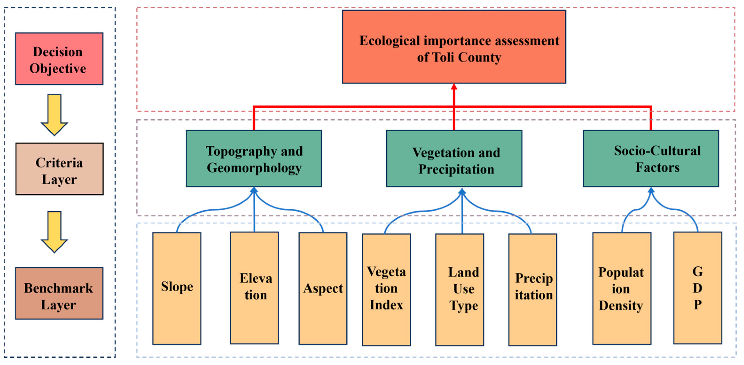
The key evaluation factors were used to study the extent of human impact [42] based on the significance of Toli County’s environment on human impact [43]. The hierarchical model of ecological importance in Toli County was categorized into three levels: the decision-making goal, criteria layer, and benchmark layer (Figure 3) [44]. The scaling method of the AHP was used to compare evaluation factors. The data were collected by distributing questionnaires to experts. Data were collected by distributing questionnaires to a total of 45 experts in the field of mine ecological restoration, resulting in a judgment matrix [45]. In the matrix, bij represents the relative importance of Bi to Bj, the level of importance is usually represented by numbers.
First, the consistency index (CI) was calculated (to check whether the hierarchical single ordering was confirmed) via the following formula Equation (2):
C I = λ m a x n n 1 ,
where λmax is the maximum eigenvalue of the matrix, and n is the matrix order. The closer the CI is to zero, the better the consistency, and vice versa [46]. The random consistency index (RI) was introduced to measure the magnitude of CI.
The consistency ratio (CR) is a parameter used to test the consistency of a matrix, which is derived as follows Equation (3):
CR = CI/RI.
The results of single rankings within the same level were used to test the overall ranking and consistency [47]. The composite weights of each element in each level were calculated using the Eigenvector method, which determined the weights of evaluation factors at both the criterion and reference levels. The following formula Equation (4) was used to calculate the weights of ecological importance evaluation factors in Toli County:
A × W = λmax × W,
where A represents the matrix of weight ratios; W is the weight vector [48]. By calculating each weight vector W via Equation (4) and normalizing it, the factor weights within each judgment matrix were obtained.

2.3.3. Strategy for the Grading Planning of Abandoned Mines

The classification planning conducted in this study established three-phase restoration projects for abandoned mines in Toli County. However, the sequencing of restoration for multiple abandoned mines within each phase still required determination [49]. To address this, the degree of harm caused by each abandoned mine was utilized as a grading criterion, and principal component analysis (PCA) was employed to establish the restoration sequence within each project phase [50].
The PCA is a linear dimensionality reduction technique that uses variance to measure the differences in data [51]. Based on this characteristic, it was used to formulate the grading planning strategy. Abandoned mine characteristics were selected as influencing factors to calculate their comprehensive scores [52]. Based on the latter values, the ranking of the danger levels of abandoned mines within the affected area was analyzed, determining the order for the restoration of abandoned mines [53].
The selection of grading influencing factors primarily considered the harmfulness of abandoned mines and chose the respective evaluation indices [54]. Data preprocessing was performed to prepare the indices for analysis. Initially, the data size related to influencing factors should be positively correlated with the analysis objectives [55]. Therefore, to appropriately classify and grade abandoned mines, we applied a Z-Score method to normalize the data and assess the relative position of each mine within the dataset. The Z-Score formula is given as
Z = X μ σ ,
where Z is the Z-Score, X is the value of the indicator (e.g., area, distance, etc.) for each mine, μ is the mean of the indicator values, σ is the standard deviation of the indicator values.
This method allows us to standardize the indicators, enabling comparison of different variables with varying units and scales. By applying this Z-Score normalization, the mines are classified into various categories, making it easier to assign them to appropriate zoning areas for restoration.
The grading management of abandoned mines primarily considers hazards posed by abandoned mines to humans and the ecological environment [56]. PCA is a method of linear dimensionality reduction that uses variance to measure the variability in data. Based on this characteristic, PCA was used in this study to determine grading planning strategies. The comprehensive score of abandoned mines was evaluated by selecting characteristics of abandoned mines as influencing factors. According to the comprehensive score, the level of danger of abandoned mines within the impact area was analyzed, and a ranking was made for the order of restoration of abandoned mines [57]. Therefore, the hazards of abandoned mines were also comprehensively classified into those concerning (i) safety for humans and nature, and (ii) economic impact. In the PCA, four factors were ultimately selected: distance, land category, area, and ecology indices (Table 2) [58].

3. Results

3.1. Abandoned Mine Zoning Planning

To facilitate the implementation of future remediation projects, the zoning requirements for abandoned mines necessitated the delineation of areas exhibiting high contiguity and concentrated spatial distributions of abandoned mines earmarked for remediation. Spatial coordinates, specifically longitude and latitude, were selected as evaluation factors due to their direct representation of the spatial distribution of abandoned mines. However, geographically proximate abandoned mines may be separated by natural barriers such as mountains and rivers, potentially impeding the practical execution of remediation efforts. Recognizing the critical role of transportation routes in ensuring mine accessibility, a road index was incorporated as an additional evaluation factor [59]. The assignment of road index values followed a systematic approach: first, the primary transportation routes within the region were identified and assigned specific values; second, the distances between each abandoned mine and these main roads were measured to determine the nearest road for each mine; finally, the road index value for each mine was defined based on its proximity to the nearest road. This methodology aimed to digitize and differentiate transportation routes, thereby enhancing the meaningfulness and utility of the road indices in the zoning process.
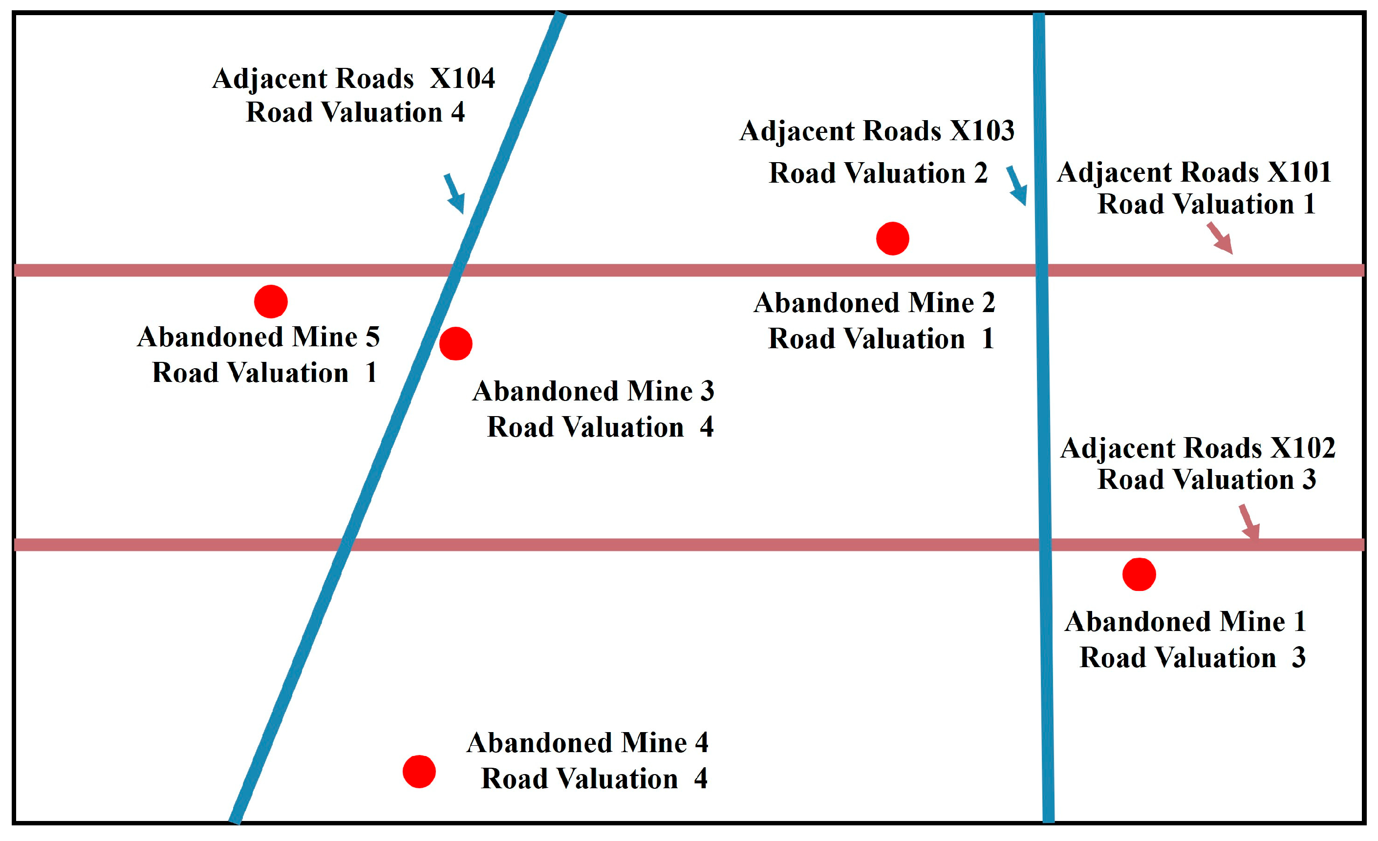
The purpose of assigning values to roadways is to digitize and differentiate roads, while also ensuring that road indicators contribute meaningfully to the clustering and zoning process [60]. The road value assignment follows a specific rule: roads oriented east–west are assigned odd numbers, with values increasing sequentially from east to west, while roads oriented north–south are assigned even numbers, with values increasing sequentially from north to south. Under this assignment scheme, adjacent or intersecting roads will have minimal value differences, whereas roads with greater spatial separation will exhibit larger value differences, thus optimizing the clustering and zoning outcomes. As illustrated in Figure 4, taking the roads and abandoned mines shown in the figure as examples: Highway X101 is assigned a value of 1, Highway X102 is assigned a value of 3, Highway X103 is assigned a value of 2, and Highway X104 is assigned a value of 4. Abandoned mine 1, located near Highway X102, is assigned a road indicator value of 3, while abandoned mine 2, located near Highway X101, is assigned a road indicator value of 1.
The standardized results on the longitude [61], latitude, and road index data for the abandoned mines in Toli County were designated from M001 to Mn (Table 3).
The final clustering results for standardized basic data of abandoned mines in Toli County with K = 3 in K-means clustering analysis [62]. Three abandoned mine zones were identified in Toli County. Zone 1 had abandoned mines, numbered from Q1 to Qa. Zone 2 had B abandoned mines, numbered from M1 to Mb. Finally, Zone 3 had C abandoned mines, numbered from N1 to Nc.

3.2. Abandoned Mine Classification Planning

While the zoning plan successfully categorized abandoned mines in Toli County based on contiguity, it did not specify the management timelines for each zone. To address this limitation, a comprehensive environmental assessment of Toli County was conducted using the hierarchical analysis method, with the degree of impact on human activities serving as the primary evaluation criterion. Based on the results of this zoning analysis, the remediation projects for abandoned mines in Toli County were subsequently delineated into first, second, and third phases.
An evaluation was conducted in Toli County based on the importance of the environmental impact on local inhabitants. Three ecological factors were primarily chosen: topography and geomorphology, vegetation and precipitation, and socio-cultural aspects. The degree of human impact was analyzed through eight secondary factors: elevation, aspect, slope, vegetation index, land use type, precipitation index, population density, and GDP [63,64]. The ecological importance hierarchical model of Toli County was subdivided into the following three layers: the decision goal criterion layer, the criterion layer, and the benchmark layer. The decision goal was the final evaluation result; the criterion layer comprised the three ecological factors, and the benchmark layer comprised eight secondary factors under these three ecological factors.
Pairwise comparisons of evaluation factors were conducted based on the degree of impact on humans, assigning values according to expert scoring. The judgment matrices for ecological importance, topography, geomorphology, vegetation, precipitation, and socio-cultural aspects of Toli County were I1, I2, I3, and I4, respectively, and had the following forms Equations (6)–(9):
I 1 = 1 1 2 1 6 4 1 1 4 6 4 1 ,
I 2 = 1 1 2 2 2 1 3 1 2 1 3 1 ,
I 3 = 1 2 1 2 1 2 1 1 3 2 3 1 ,
I 4 = 1 1 1 1 .
The consistency ratios of the four judgment matrices I1, I2, I3, and I4 were 0.0088, 0.0088, 0.0088, and 0, respectively, all passing the consistency test [65]. The analysis’s overall hierarchical sorting CR value was 0.0088, i.e., it passed the consistency test, allowing for calculating weights for the evaluation factors.
By integrating Equations (2)–(4) with Equation (6), the weights of the criteria layer factors were determined to be 0.1061, 0.1929, and 0.7010, respectively. Subsequently, the evaluation indicators within each criterion were calculated for the benchmark layer. By combining Equations (2)–(4) with Equations (7)–(9), the weights of all evaluation factors in the benchmark layer were obtained. Finally, the weights of ecological environmental importance evaluation factors for Toli County were obtained (Table 4).
After determining the weights of each evaluation factor, the importance of each factor’s impact on humans in Toli County was assessed. Given that different factors vary in their degree of significance to human populations, each factor’s importance was evaluated individually. For example, regarding slope, human activities typically occur in areas with gentler gradients; therefore, regions with lower slopes hold greater significance for human habitation and production. Consequently, the impact of slope on humans is inversely proportional to its numerical value. The zoning principles for each evaluation factor are outlined in (Table 5).
The remote sensing data for each ecological factor in Toli County were reclassified, and the impact of each category was evaluated and assigned numerical values. To eliminate the influence of dimensionality and enhance the assessment of importance, the data for the eight evaluation factors were categorized into Primary Impact Zones, Secondary Impact Zones, and Tertiary Impact Zones based on a hierarchical evaluation principle. Assigned values of 3, 2, and 1 were allocated to these zones, respectively, with the magnitude of the assigned values being proportional to their degree of importance (Table 6).
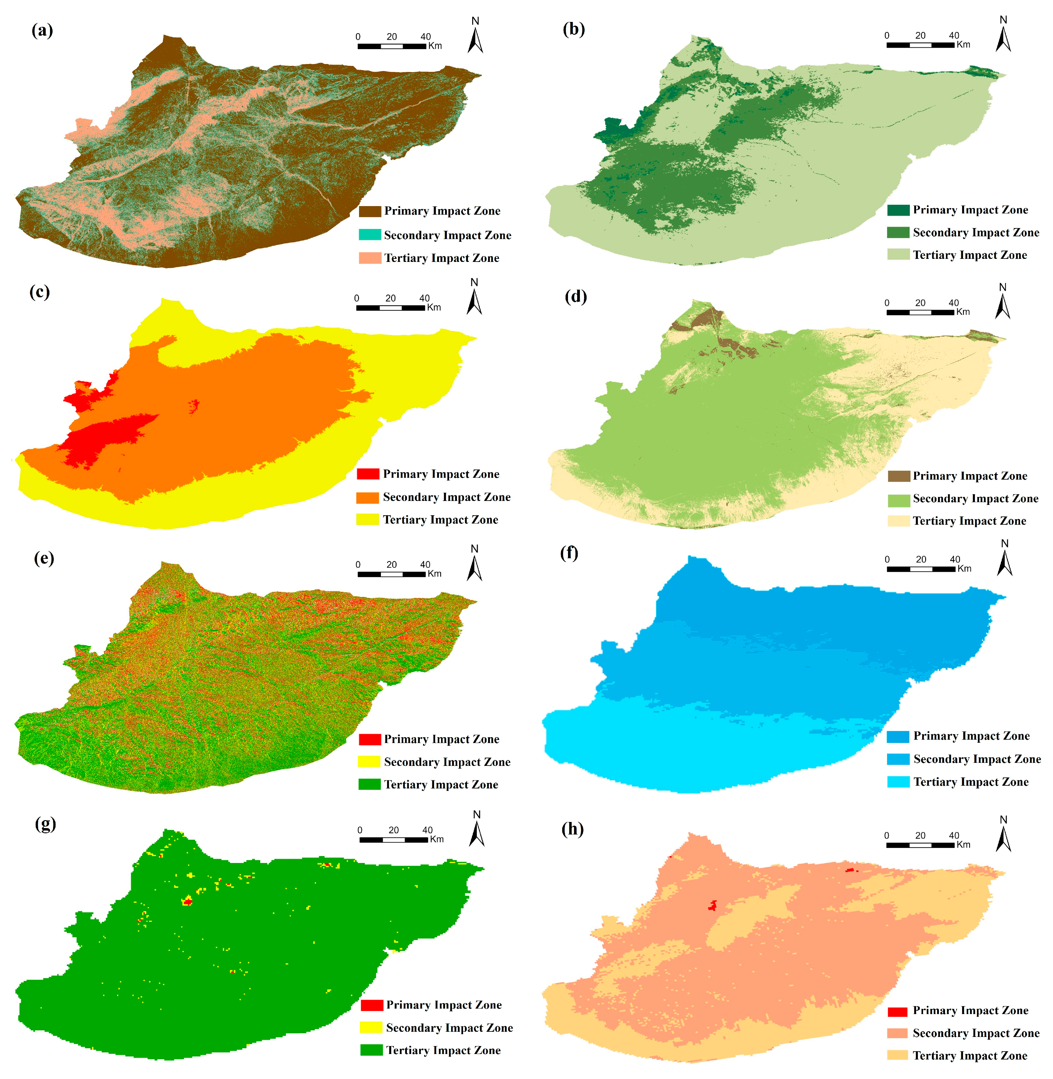
Based on the aforementioned analysis of the importance and weight assignment of the evaluation factors, spatial overlay processing and analytical calculations were conducted on the remote sensing data for the eight assessment factors in Toli County. This process categorized the factors into three distinct classes: Primary Impact Zone, Secondary Impact Zone, and Tertiary Impact Zone. Taking slope as an example, as illustrated in Table 4, the remote sensing data were reclassified by assigning a value of 3 to slopes between 0 and 5°, a value of 2 to slopes between 5 and 10°, and a value of 1 to slopes exceeding 10°. This reclassification resulted in the zonation map for the slope factor in Toli County (Figure 5a). Similarly, the remaining factors were reclassified according to their respective levels, thereby producing zoning maps for all eight evaluation factors in Toli County (Figure 5a–h).
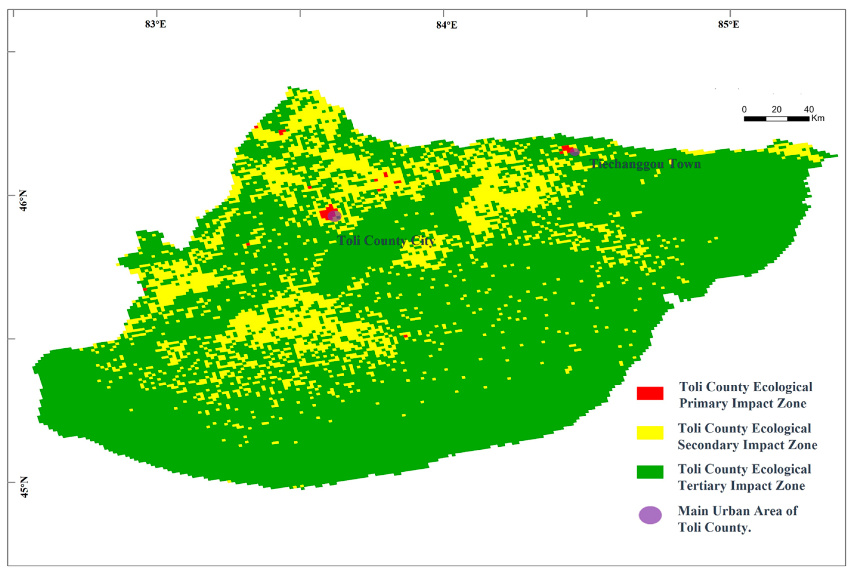
By combining the latter map with the impact weights of each factor and performing grid calculations and overlaying, the comprehensive evaluation map of the ecological importance of Toli County was constructed (Figure 6). The most significant factors affecting the importance levels of abandoned mine areas in Toli County were the population density, GDP, and vegetation index. The primary Impact Zone in Toli County, influenced by anthropogenic factors like population density and GDP, was mainly located near Toli County City and Tiechanggou Town. Influenced by natural factors such as precipitation, vegetation, and land use, the Secondary Impact Zone was concentrated in the northwestern part of Toli County. Other areas in Toli County with less significant impacts formed the Tertiary Impact Zone, mainly covering the eastern and southern parts of Toli County.
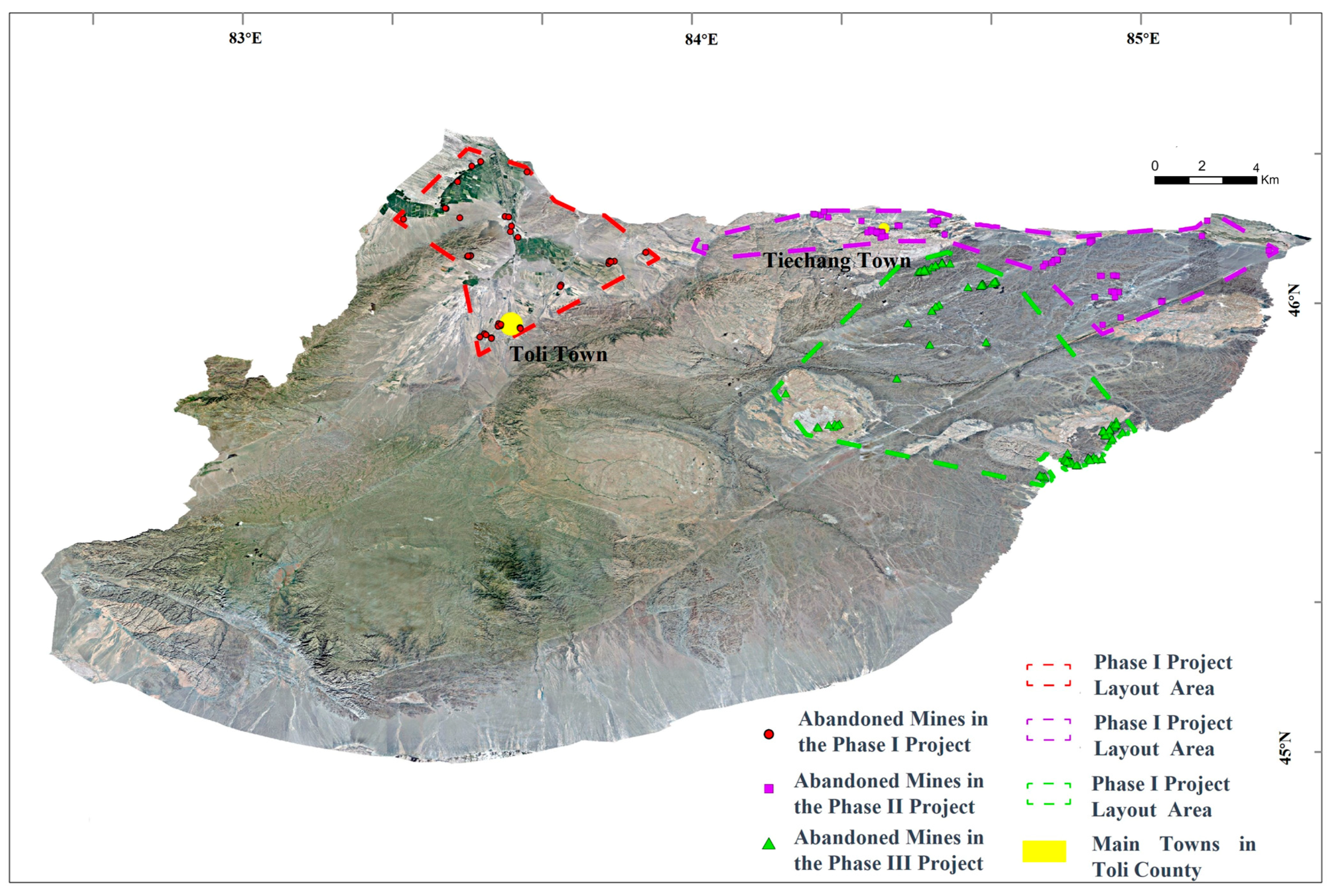
Using mathematical quantitative modeling, the ecological impact importance evaluation system was established for Toli County. The numbers and ratios of importance levels for abandoned mine areas were determined by integrating zone planning, ultimately subdividing the project into three phases. The base map’s remote sensing data is sourced from Maxar Technologies (Figure 7).
The red area in the figure represents Phase I of the project, the purple area denotes Phase II, and the green area corresponds to Phase III. The rationale for this delineation is as follows:
(1)
Abandoned Mine Zone 1: This zone is predominantly characterized by primary and secondary ecological impacts in Toli County, significantly affecting both human society and the ecological environment. Consequently, it has been designated as the first phase of the abandoned mine restoration project in Toli County. Priority remediation efforts will focus on the abandoned mines within this area, which is termed the Human Factors-Dominated Ecological Priority Restoration Zone.
(2)
Abandoned Mine Zone 2: This zone primarily exhibits primary and tertiary impacts in Toli County. It is therefore designated as the second phase of the abandoned mine restoration project. Although this area experiences lower levels of human activity, it benefits from favorable natural conditions such as adequate precipitation and temperature, indicating substantial ecological potential. As a result, abandoned mines within this zone will undergo secondary remediation. This area is named the Climate Factors Dominated Ecological Key Restoration Zone.
(3)
This zone is mainly characterized by secondary and tertiary impacts in Toli County, posing minimal threats to human society and the natural environment. Additionally, it has limited potential for ecological development. Consequently, it is classified as the third phase of the abandoned mine restoration project in Toli County, with remediation activities scheduled subsequently. This zone is designated as the Topography Factors-Dominated Ecological Routine Restoration Zone.

3.3. Abandoned Mine Grading Planning

The above classification plan outlined the three phases of restoration projects for the abandoned mines in Toli County. However, within each phase, the sequence for restoring multiple abandoned mines still had to be planned. The restoration sequence for abandoned mines within each restoration project was established based on the degree of hazard posed by the mines, using principal component analysis as the grading standard.
In the first phase of the Toli County project, data regarding the distance, land category, area, and ecological indices of abandoned mines were systematically analyzed. Due to policy requirements, the abandoned mines were anonymized and assigned numerical identifiers ranging from Q001 to Qa (Table 7). To mitigate the influence of differing units and ensure comparability, the raw data collected were standardized using the Z-Score normalization method (Table 6).
PCA was used for data analysis to rank abandoned mines within the project’s first phase. PCA applicability is known to require the Kaiser-Meyer-Olkin (KMO) value of no less than 0.6 and the significance (Sig) of Bartlett’s test of sphericity not exceeding 0.05. The KMO value of this model is 0.613, and Bartlett’s test of sphericity value is 0.0001, both meet the requirements for analysis. The indices of the performed PCA had a good degree of association, allowing for the PCA to be conducted [66].
Further extract principal components from the total variance with initial eigenvalues greater than 1, calculated as principal components 1 (Y1) and 2 (Y2). Together, they accounted for 87.11% of the total variance. (Table 8) shows the total variance explanation for the PCA [67].
Consequently, the hazard assessment model for abandoned mines was characterized by Principal Components 1 and 2. To elucidate the coupling relationships between the four evaluation indicators and the hazards associated with abandoned mines, the interactions between these four rating indicators and the principal components were subsequently calculated (Table 9). A comprehensive score calculation for the principal components was conducted to determine the restoration order of abandoned mines in the severe impact zone, where X1 represents the ecological index, X2 is the land category index, X3 is the distance index, and X4 is the area index. The weights of the evaluation indices in each principal component were calculated
The corresponding coefficients of each evaluation index were calculated using the data in the component matrix table and the eigenvalues of the corresponding principal components. The following formulas Equations (10) and (11) were used to determine the composite scores for principal components 1 and 2:
Y1= 0.6014 × X1 + 0.5884 × X2 + 0.4880 × X3 + 0.2238 × X4,
Y2 = −0.2393 × X1 − 0.3256 × X2 + 0.2903 × X3 + 0.8678 × X4.
Combining various ratios of principal components Y1 and Y2, the final comprehensive score Y for each abandoned mine was derived using Equation (12):
Y = 0.61115 × Y1 + 0.25998 × Y2.
Using the above formulas for each principal component and the data of each index (after preprocessing), the comprehensive scores of principal components 1 (Y1) and principal component 2 (Y2) for each abandoned mine, as well as the overall mine score Y, were obtained. The abandoned mines within the project phase were graded and ranked based on the comprehensive score Y. The comprehensive scores and grading order of the abandoned mines in phase one of the project (Table 10).
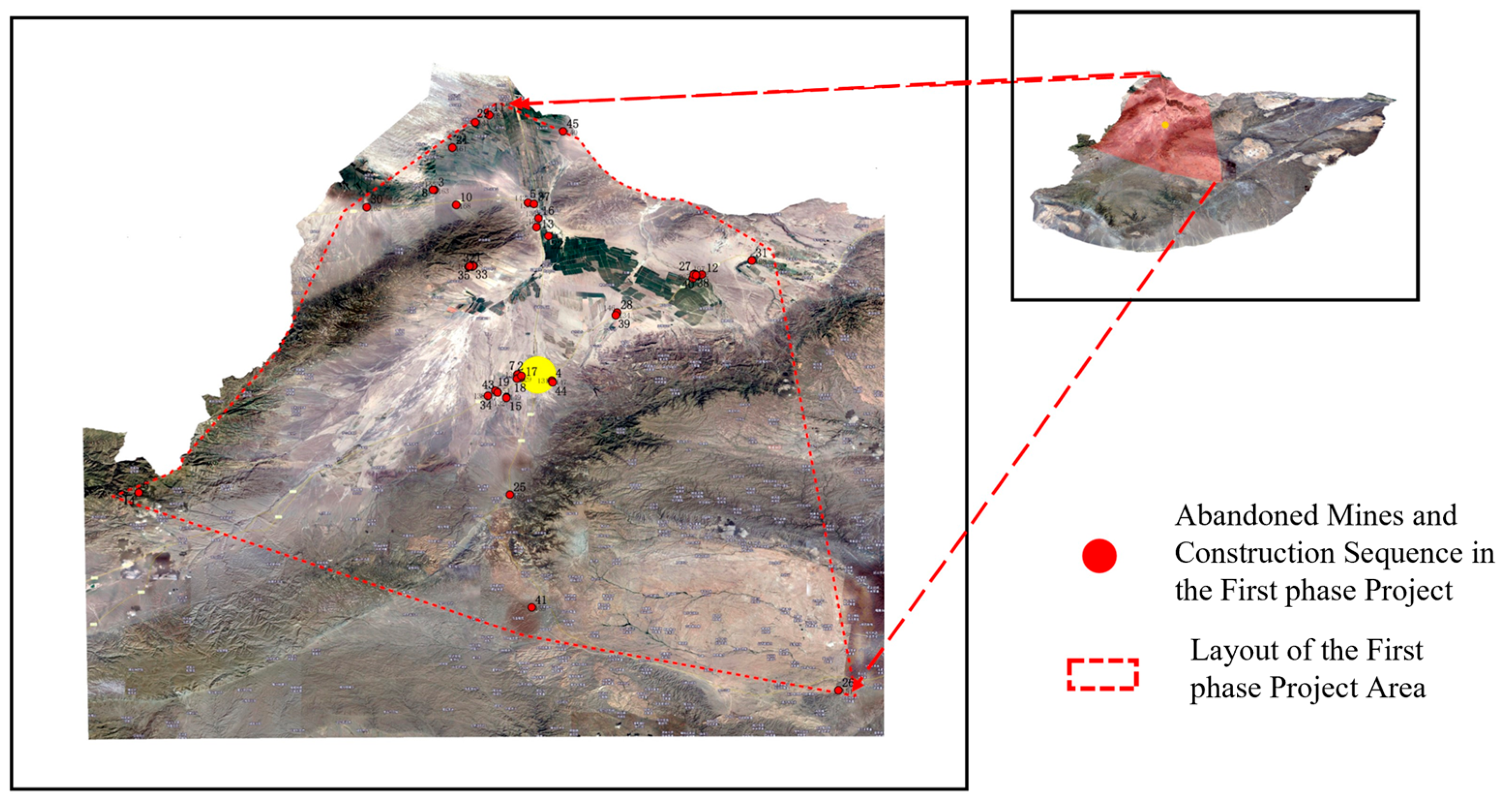
The grading and ranking of abandoned mines were directly proportional to their threat to human health and the ecological environment, meeting the requirements of grading planning. This approach achieved graded management planning for restoring abandoned mines from ecological safety and functional perspectives. The arrangement of the first phase of the abandoned mine project in Toli County (Figure 8).
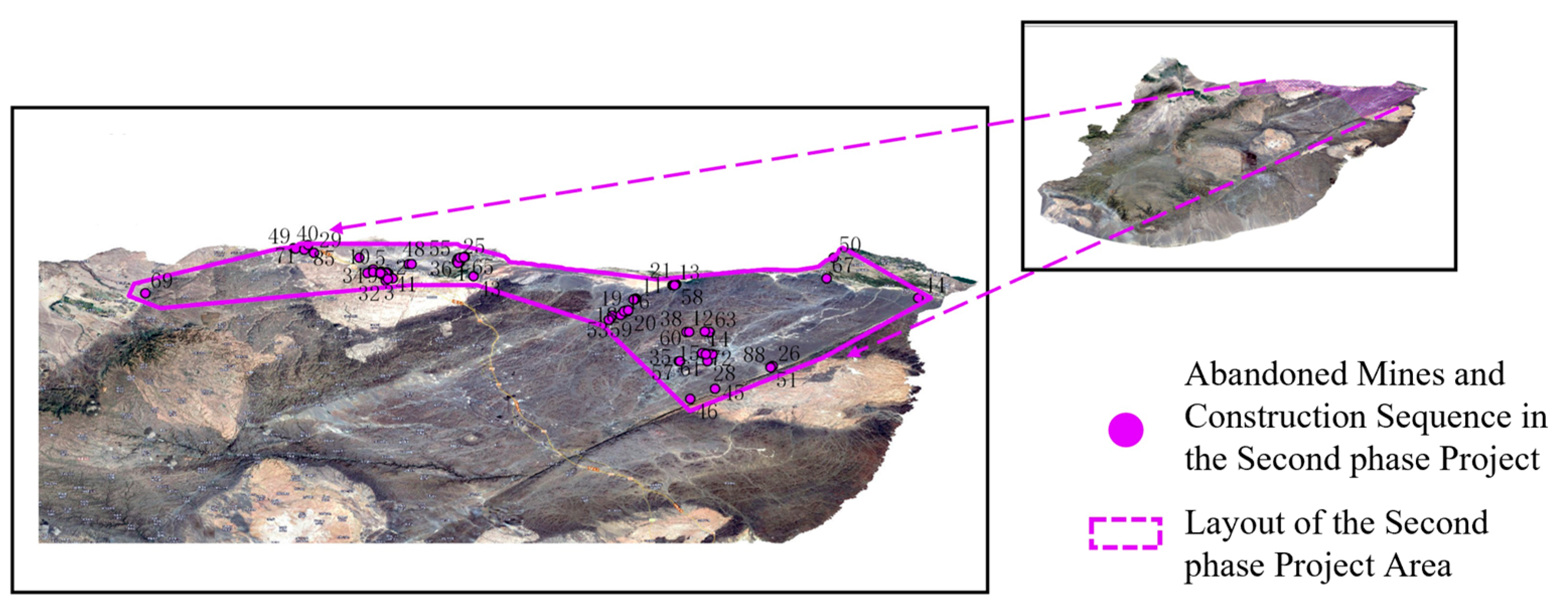
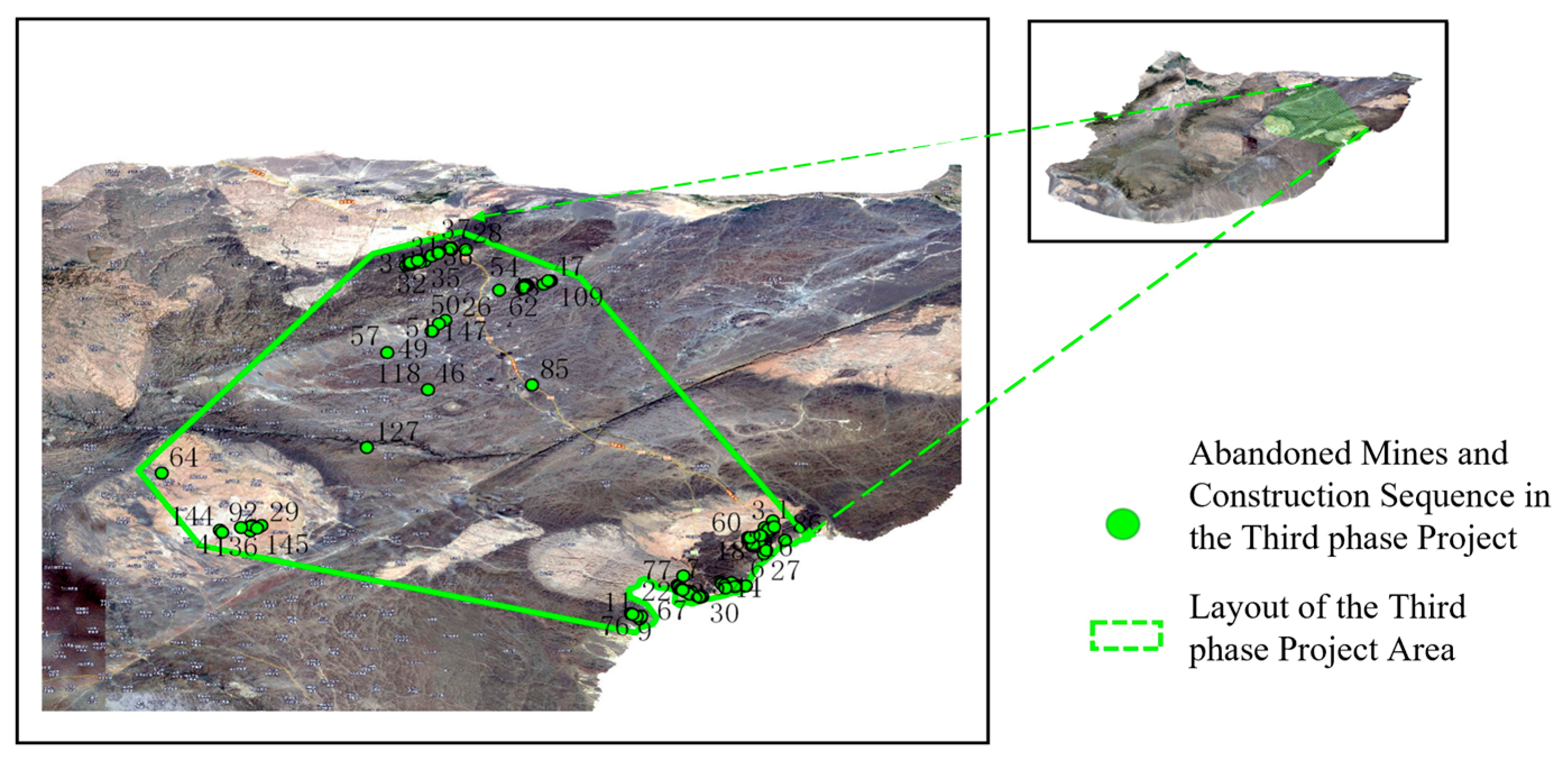
By applying the same methodology, the restoration sequences for abandoned mines exhibiting secondary (Figure 9) and tertiary (Figure 10) impacts in Toli County were subsequently determined.
4. Discussion

4.1. Advantages of Zoning, Classification, and Grading Planning for Abandoned Mines

4.1.1. Advantages of Zoning Planning for Abandoned Mines

As can be seen from Figure 7, the abandoned mines in Toli County were primarily distributed in the central, northwest, and northeast parts of the county, with only a few scattered in other areas. zones 1 and 2 show contiguous effects. However, the continuity of Zone 3 is significantly poorer (Figure 11a), as the complex terrain such as mountains and rivers, the road does not directly connect the north and south sections, which increases the actual driving distance, affects the management cost, and reduces the zoning benefit. The distribution of abandoned mines in Zone 2 and Zone 3 is concentrated (Figure 11b), which are connected by county road and S201 expressway, and have a good contiguous effect.
By incorporating longitude, latitude, and the road index into the K-means clustering, the delineated zones are not only spatially coherent but also accessible along the main transport corridors of Toli County [68]. Compared with the control scheme that uses only geographic coordinates, the zoning scheme with the road index produces clusters that correspond to groups of mines that can be reached via the same highway or county-road network, rather than mines that are close in Euclidean distance but separated by mountains or river valleys. This improves the practicality of the planning results, because remediation projects can be organized as contiguous engineering packages, reducing mobilization costs, travel time, and difficulties in on-site supervision. Similar accessibility-based zoning ideas have been adopted in regional ecological restoration and watershed management planning, where transport or hydrological connectivity is used to group management units; our results demonstrate that this concept is also effective for abandoned mine clusters in arid mountainous regions.

4.1.2. Advantages of Classification Planning for Abandoned Mines

A work schedule can be arranged for each zone by combining the comprehensive ecological importance evaluation map with the three abandoned mine zones (Table 11).
The proportions of abandoned mines situated within various impact zones for the Phase III restoration project in Toli County are presented in Table 11. The conclusions drawn are as follows: (1) In Phase I, abandoned mines comprised 19.6% of the primary impact zone, 35.3% of the secondary impact zone, and 45.1% of the tertiary impact zone. (2) In Phase II, abandoned mines accounted for 8.7% of the primary impact zone, 21.7% of the secondary impact zone, and 69.6% of the tertiary impact zone. (3) In Phase III, no abandoned mines were located within the primary impact zone, 5.8% were situated within the secondary impact zone, and 94.2% were found within the tertiary impact zone.
The AHP-based ecological importance evaluation provides an explicit link between the spatial zones and the underlying ecological–socioeconomic context [69]. By weighting vegetation index, precipitation, population density, GDP, and other indicators, the method highlights areas where abandoned mines intersect with dense human activities and high-value ecosystems. The fact that Phase I restoration projects contain the largest share of mines located in primary and secondary impact zones indicates that the planning scheme successfully concentrates early remediation efforts in places where ecological functions and human safety are most vulnerable. In contrast, Phases II and III are dominated by secondary and tertiary impact zones, reflecting a gradual shift from urgently needed interventions to more routine ecological improvement. This priority pattern agrees with regional ecological sensitivity and restoration studies in other parts of China, where population density, economic output, and vegetation condition are also identified as dominant drivers of ecological importance and high-impact zones are preferentially targeted for protection and restoration. Thus, the classification planning in this study is not only internally consistent but also aligned with broader regional experiences.

4.1.3. Advantages of Grading Planning for Abandoned Mines

The first principal component (Y1) accounts for 61% of the cumulative score contribution. According to Equation (6), both ecological indicators and land category indicators significantly influence Y1, indicating that Y1 primarily represents the hazard impacts related to the ecological functionality of abandoned mines. The second principal component (Y2) accounts for 26% of the cumulative score contribution. As demonstrated by Equation (7), area indicators and distance indicators exert positive influences on Y2, whereas ecological indicators and land category indicators have negative influences. This suggests that Y2 mainly reflects the hazard impacts associated with the ecological safety of abandoned mines.
Furthermore, by integrating Equations (10) and (11) into Equation (12), the following equation for the comprehensive score Y of the abandoned mines and the four indices, namely ecological index X1, land category index X2, distance index X3, and area index X4, was obtained Equation (13):
Y1 = 0.3053 × X1 + 0.2749 × X2 + 0.3737 × X3 + 0.3623 × X4
The standardized coefficients for the ecological index (X1), land category index (X2), distance index (X3), and area index (X4) are 0.3052, 0.2749, 0.3737, and 0.3623, respectively, in relation to the comprehensive hazard scores of abandoned mines. All four indicators exert a positive influence on the hazards associated with abandoned mines, with the distance and area indices having relatively greater impacts. This underscores the significant role of ecological safety levels in the planning of abandoned mine remediation. Consequently, project prioritization should focus on remediating abandoned mines that are located near densely populated areas and those that encompass large, disturbed areas.
The PCA-based grading further refines restoration priorities within each construction phase by revealing which combinations of mine characteristics drive hazard levels [70]. In our analysis, the first principal component, dominated by ecological and land use indicators, explains around 60% of the total variance and can be interpreted as an “ecological function” dimension, while the second component, controlled mainly by area and distance indicators, represents an “exposure and safety” dimension. This two-axis structure is comparable to PCA-based evaluations of water-quality risk, regional drought vulnerability, and other environmental hazards in China and elsewhere where the first component typically captures natural or land-cover conditions and the second reflects human disturbance or exposure. The similarity suggests that the relative influence of ecological status versus exposure is robust across different regions and environmental problems.
Transforming the principal components into a single comprehensive score yields a continuous index that can be used to rank individual mines within the same classification zone. Mines with higher scores are simultaneously located in ecologically important areas, closer to settlements, and with larger disturbed areas, meaning that remediation there is likely to deliver the greatest reduction in ecological and safety risk per unit investment. Compared with approaches that only consider administrative priority or single indicators, the PCA-based grading offers a more transparent and quantitative basis for sequencing projects and can be readily combined with other decision-making tools in future work.
While this study focuses on the specific conditions of Toli County, the framework developed for zoning, classification, and grading of abandoned mines is flexible and can be adjusted to suit different environmental contexts. The integration of AHP and PCA allows for the customization of factors depending on the local context, making the methodology applicable to a wide range of mining areas with varying ecological and socio-economic conditions. In addition, future studies could explore the adaptation of this approach to different mining types (e.g., coal, metals, non-metallic minerals) and the corresponding changes in the factor weights and hazard assessments.
By refining these elements, this model can be applied globally, offering a robust tool for mine restoration planning in diverse geographic and environmental settings.

4.2. Policy Implications

The Chinese authorities promoted the ecological restoration of regional historical legacy mines, issuing such regulatory documents as “Notification on supporting the demonstration project for ecological restoration of historical legacy abandoned mines” and “Opinions on exploring the use of market-oriented approaches to promote mine ecological restoration” [71]. However, the ongoing restoration process is still susceptible to subjective factors and lacks scientific and standardized scheduling, resulting in unreasonable restoration plans, low quality of restoration, slow progress, and untimely management of key abandoned mines for restoration.
Based on the above analysis of the case study area, the following suggestions have been proposed: (1) Prioritize and categorize management policies for abandoned mines, classify the mines to ensure effective allocation and use of resources, and prioritize the management of high-hazard abandoned mines. (2) Strengthen scientific and standardized scheduling to reduce restoration costs and improve management efficiency and quality. (3) Establish demonstration applications for management planning and formulate and improve relevant laws and policies. To ensure effective and orderly management of mine restoration.

4.3. Limitations and Future Work

Despite the above useful findings, this study has the following two main limitations. Firstly, it formulated restoration plans only for one case study region, namely Toli County, while differences in the environments of various sites and regions imply respective differences in the main influencing factors for the grading, classification, and zoning planning of abandoned mines. Secondly, the proposed planning covered overall abandoned mines in the region under study without considering the specific management plans for individual abandoned mines [72].
In the follow-up study, more attention will be dedicated to the following aspects: (1) In the planning strategy stage, adjust the evaluation factors and their weights in the plan according to the environmental characteristics of different regions, forming planning strategies for arid areas, cold areas, alpine areas, monsoon areas, and other different environments. (2) Based on the overall planning of abandoned mines and the analysis of the mines’ hazards, guide the arrangement of individual management projects for abandoned mines. (3) Since the restoration cycle of abandoned mines is long, it is necessary to establish an evaluation system for restoration effects and strengthen the maintenance, monitoring, and management of the restored legacy mines [73].
Furthermore, future work could combine the AHP and PCA derived indices with multi-objective optimization techniques to refine restoration prioritization under budgetary and temporal constraints [74,75]. For example, integer programming or evolutionary algorithms could be used to identify portfolios of projects that simultaneously maximize ecological improvement (such as reductions in comprehensive hazard scores or increases in restored areas within high-importance zones) and minimize implementation costs or total travel distance along the road network. Such an approach would transform the current stepwise planning strategy into a decision-support tool that explicitly quantifies trade-offs among competing management objectives and provides more flexible scheduling options for local governments.
This planning approach sequentially employs three methods, advancing the research on planning strategies. A comprehensive summary of the different methods used, evaluation factors, and results is provided, along with an outline of the study’s objectives and key findings. The summary is presented in the following Table 12.
In addition to surface ecological factors, it is essential to consider subsurface conditions, particularly the geological environment, when planning ecological restoration in abandoned mine areas [76]. Mineral resource development causes significant disturbances not only to the surface but also to the subsurface, including soil composition, groundwater quality, and geological stability. These underground factors can influence the success of restoration efforts, as changes in the subsurface environment may affect water retention, soil fertility, and overall ecosystem stability.
Geological conditions such as soil structure, permeability, and the presence of contaminants in the groundwater should be incorporated into the restoration strategy [77]. For instance, areas with unstable geological conditions may require more intensive interventions to stabilize the soil and prevent further degradation. Additionally, the quality of groundwater, which can be affected by previous mining activities, should be monitored and addressed to ensure the health of ecosystems in restored areas.
To further validate the model results, future research could incorporate ground-truth verification by collecting field data from abandoned mine sites in Toli County or similar regions. This would allow for a direct comparison between the predicted restoration priorities and actual ecological conditions. In addition, we plan to compare the model’s outcomes with existing regional restoration plans from similar mining areas, such as region, to assess the accuracy and applicability of the proposed methodology. The validation through both ground-truthing and comparative analysis with regional plans would provide further support for the reliability of the restoration prioritization framework developed in this study.

5. Conclusions

This study introduces a novel framework for the zoning, classification, and grading management of abandoned mines, which mitigates the influence of subjective factors in the decision-making process. By integrating Cluster Analysis (CA), Analytic Hierarchy Process (AHP), and Principal Component Analysis (PCA), this research establishes a spatially and ecologically prioritized approach for restoration planning. The findings of this study contribute significantly to the field of ecological restoration by providing a systematic methodology for evaluating and addressing the hazards posed by abandoned mines.
(1)
Spatial Concentration and Connectivity: The use of longitude, latitude, and road indices facilitated the identification of spatially contiguous mine zones, effectively overcoming geographical barriers such as mountains and rivers. The cluster analysis methodology allowed for the delineation of three contiguous abandoned mine zones, significantly reducing the logistical challenges and costs associated with subsequent remediation efforts.
(2)
Zoning Classification Based on Ecological Importance: The study identified population density, economic indicators, vegetation, and precipitation as the primary factors influencing the ecological importance of mine zones. A quantitative ecological impact evaluation system was developed for Toli County, leading to the classification of the study area into three distinct zones based on ecological priority: Human Factors-Dominated Ecological Priority Restoration Zone; Climate Factors-Dominated Ecological Key Restoration Zone; Topography Factors-Dominated Ecological Routine Restoration Zone. This classification provides a clear basis for prioritizing restoration efforts according to the ecological significance of each zone.
(3)
Hazard Assessment and Grading: PCA was employed to assess the ecological hazards of abandoned mines, focusing on ecological function and safety. By selecting four key indicators—distance, area, ecology, and land category—the study quantified the environmental and safety risks posed by abandoned mines. The analysis demonstrated that distance and area are the primary indicators influencing the severity of these hazards, thereby aiding in the prioritization of remediation efforts.
Although this study focuses on abandoned coal mines located in an arid region, where land degradation is the dominant ecological issue and water pollution is relatively limited, the evaluation framework can be readily extended to metal mining areas in which off-site water quality is the primary concern. In such cases, water-quality indicators (e.g., concentrations of heavy metals in surface and groundwater, pH, and major ions) can be incorporated as additional evaluation factors in the AHP system, and their spatial distributions can be used to further refine the priority zoning for ecological restoration. This demonstrates that the proposed model is adaptable and capable of supporting region-specific planning for different types of mines and associated environmental stressors.

Author Contributions

Conceptualization, W.G. and H.L.; methodology, M.X.; software, H.W. (Haosen Wang); validation, T.L., D.H. and C.F.; formal analysis, H.L.; investigation, W.G.; resources, M.X.; data curation, H.W. (Haosen Wang); writing—original draft preparation, W.G.; writing—review and editing, H.L.; visualization, H.W. (Haipei Wang); supervision, M.X.; project administration, M.X.; funding acquisition, W.G. All authors have read and agreed to the published version of the manuscript.

Funding

This research was funded by Xinjiang Uygur Autonomous Region “Tianshan Talents” Scientific Research Project—Young Top Talents, grant number 2023TSYCCX0081; Xinjiang Uygur Autonomous Region Science and Technology Plan Project—Major Science and Technology Special Project, grant number 2024A03001-2; the Science and Technology Plan Project of Kekedala City, the Fourth Division of the Xinjiang Production and Construction Corps, grant number 2025ZR005; Youth Project of the Natural Science Foundation of Xinjiang Uygur Autonomous Region, grant number 2025D01C259; Xinjiang Uygur Autonomous Region Science and Technology Plan Project—Major Science and Technology Special Project, grant number 2024A01002-1; Xinjiang Uygur Autonomous Region Hami City Scientific Research and Technology Development Project, grant number hmkj2025004.

Data Availability Statement

Some or all data, models, or codes generated or used during the study are available from the corresponding author by request.

Acknowledgments

The authors thank the editor for providing helpful suggestions for improving the quality of this manuscript.

Conflicts of Interest

Author Defeng Hou was employed by the company Nan Open-Pit Coal Mine, Xinjiang Tianchi Energy Co., Ltd. The remaining authors declare that the research was conducted in the absence of any commercial or financial relationships that could be construed as a potential conflict of interest.

References

  1. Zhang, J.-W.; Ge, C.-Z.; Duan, X.-M.; Wang, K.; Zhou, Q.; Hao, C.-X. Integrating SDGs into China’s ecological civilization construction: Practical indicators and progress assessment. Ecol. Indic. 2024, 169, 112921. [Google Scholar] [CrossRef]
  2. Xia, S.Y.; Yang, W.; Tan, S.C. Evaluation of ecological rehabilitation models for abandoned mines using analytic hierarchy process–entropy method and sustainable development strategies. Sustainability 2024, 16, 10668. [Google Scholar] [CrossRef]
  3. Hu, Z.-Q.; Wang, P.-J.; Li, J. Ecological restoration of abandoned mine land in China. J. Resour. Ecol. 2012, 3, 289–296. [Google Scholar] [CrossRef]
  4. Li, G.-S.; Hu, Z.-Q.; Li, P.-Y.; Yuan, D.-Z.; Wang, W.-J.; Yang, K. The optimal framework and model to balance underground coal mining and cropland protection in Jining, eastern China. Resour. Policy 2021, 74, 102307. [Google Scholar] [CrossRef]
  5. Bian, Z.-F.; Inyang, H.I.; Daniels, J.-L.; Otto, F.; Struthers, S. Environmental issues from coal mining and their solutions. Min. Sci. Technol. 2010, 20, 215–223. [Google Scholar] [CrossRef]
  6. Bian, Z.-F.; Lei, S.-G.; Jin, D.; Wang, L. Several basic scientific issues related to mined land remediation. J. China Coal Soc. 2018, 43, 190–197. [Google Scholar]
  7. Ahmad, Z.; Rao, J.; Zhang, W.; Xu, G.; Meng, G.; Li, J.; Khan, S.M.; Jie, Y. Mining driven pollution impact on ecosystem health and its retrieval through green technology: A nature based sustainable solution. Environ. Pollut. 2025, 385, 127154. [Google Scholar] [CrossRef]
  8. Zine, H.; Hakkou, R.; Papazoglou, E.; Elmansour, A.; Abrar, F.; Benzaazoua, M. Revegetation and ecosystem reclamation of post-mined land: Toward sustainable mining. Int. J. Environ. Sci. Technol. 2024, 21, 9775–9798. [Google Scholar] [CrossRef]
  9. Zhang, J.; Wang, Z.; Zhuang, D.; Fu, Z.; Wang, K.; Chen, H. Evaluating the hydrological function of vegetation restoration in fragile karst area: Insights from the continuous surface and subsurface runoff monitoring. Soil Tillage Res. 2023, 234, 105847. [Google Scholar] [CrossRef]
  10. Des Roches, S.; Accola, K.L.; Faulkner, H.S.; Morgan, J.R.; Perla, B.S.; Metler, M.; Dethier, M.N.; Toft, J.D. Shoreline restoration including armor removal and log placement affect ecosystem recovery through time. Restor. Ecol. 2024, 32, e14097. [Google Scholar] [CrossRef]
  11. Cui, C.-Q.; Wang, B.; Zhao, Y.-X.; Xue, L.-M. Waste mine to emerging wealth: Innovative solutions for abandoned underground coal mine reutilization on a waste management level. J. Clean. Prod. 2020, 252, 119748. [Google Scholar] [CrossRef]
  12. Hu, Z.-Q.; Li, G.-S.; Xia, J.-N.; Feng, Z.-J.; Han, J.-Z.; Chen, Z.-X.; Wang, W.-J.; Li, G.-D. Coupling of underground coal mining and mine reclamation for farmland protection and sustainable mining. Resour. Policy 2023, 84, 103756. [Google Scholar] [CrossRef]
  13. Xiao, W.; Lv, X.-J.; Zhao, Y.-L.; Sun, H.-X.; Li, J.-Q. Ecological resilience assessment of an arid coal mining area using index of entropy and linear weighted analysis: A case study of Shendong Coalfield, China. Ecol. Indic. 2020, 109, 105843. [Google Scholar] [CrossRef]
  14. Hu, Z.-Q.; Long, J.-H.; Wang, X.-J. Self-healing, natural restoration and artificial restoration of ecological environment for coal mining. J. China Coal Soc. 2014, 39, 1751. [Google Scholar]
  15. Wang, Y.-C.; Bian, Z.-F.; Lei, S.-G.; Zhang, Y. Investigating spatial and temporal variations of soil moisture content in an arid mining area using an improved thermal inertia model. J. Arid Land 2017, 9, 712–726. [Google Scholar] [CrossRef]
  16. Zhang, J.-D.; Xi, F.-R. Study on ecological restoration of abandoned mines in China. Acta Ecol. Sin. 2020, 40, 7921–7930. [Google Scholar] [CrossRef]
  17. Petlovanyi, M.; Sai, K. Research into cemented paste backfill properties and options for its application: Case study from a Kryvyi Rih Iron-ore Basin, Ukraine. Miner. Depos 2024, 18, 162–179. [Google Scholar] [CrossRef]
  18. Li, M.-L.; He, G.; Wang, C.-K. Research on mines ecological restoration plan of territorial spatial in the new period: A case of Nanning city. China Min. Mag. 2021, 30, 71–77. [Google Scholar]
  19. Zhang, Y.-H.; Hu, Z.-Q.; Han, J.-Z.; Liu, X.-Z.; Feng, Z.-J.; Zhang, X. Spatiotemporal patterns and driving factors of ecological restoration regions: Insights from multi-scale analysis. Environ. Impact Assess. Rev. 2025, 115, 108020. [Google Scholar] [CrossRef]
  20. Fois, M.; Murgia, L.; Bacchetta, G. Plant diversity and species composition of the abandoned mines of the Iglesiente mining district (Sardinia, Italy): A restoration perspective. Ecol. Eng. 2023, 188, 106879. [Google Scholar] [CrossRef]
  21. Gligor, V.; Nicula, E.-A.; Crețan, R. The identification, Spatial distribution, and reconstruction mode of abandoned mining areas. Land 2024, 13, 1107. [Google Scholar] [CrossRef]
  22. Xie, J.; Liu, Y.; Xie, M.; Xia, L.; Yang, R.; Li, J. Exploring the restoration stability of abandoned open-pit mines by vegetation resilience indicator based on the LandTrendr algorithm. Ecol. Indic. 2024, 166, 112392. [Google Scholar] [CrossRef]
  23. Hu, Z.-Q.; Zhu, Q.; Xu, J.-J.; Ruan, M.-Y. Development of composite bactericides for controlling acidification pollution in coal gangue piles and their mechanisms of bacterial inhibition. Environ. Technol. Innov. 2022, 25, 102094. [Google Scholar] [CrossRef]
  24. Wang, J.-M.; Qin, Q.; Bai, Z.-K. Characterizing the effects of opencast coal-mining and land reclamation on soil macropore distribution characteristics using 3D CT scanning. Catena 2018, 171, 212–221. [Google Scholar] [CrossRef]
  25. Li, G.-X.; Kou, G.; Peng, Y. Heterogeneous large-scale group decision making using fuzzy cluster analysis and its application to emergency response plan selection. IEEE Trans. Syst. Man Cybern. Syst. 2021, 52, 3391–3403. [Google Scholar] [CrossRef]
  26. Roman, M.; Roman, M.; Grzegorzewska, E.; Pietrzak, P.; Roman, K. Influence of the COVID-19 pandemic on tourism in European countries: Cluster analysis findings. Sustainability 2022, 14, 1602. [Google Scholar] [CrossRef]
  27. Viaccoz, C.; Harasim, D.; Moss, F.C.; Rohrmeier, M. Wavescapes: A visual hierarchical analysis of tonality using the discrete Fourier transform. Music. Sci. 2023, 27, 390–427. [Google Scholar] [CrossRef]
  28. Wang, X.; Li, L.; Mu, W.; Yang, T.; An, J.; Du, Y. Diffusion mechanism of cement-based slurry in frozen and thawed fractured rock mass in alpine region. Constr. Build. Mater. 2024, 411, 134584. [Google Scholar] [CrossRef]
  29. NASA Earth Science Data. Available online: https://www.earthdata.nasa.gov/ (accessed on 17 May 2024).
  30. Chinese Academy of Sciences Center for Resource Environment Sciences and Data. Available online: https://www.resdc.cn/Default.aspx (accessed on 10 May 2024).
  31. National Earth System Science Data Center. Available online: https://www.geodata.cn/ (accessed on 15 May 2024).
  32. Zhao, Y.-L.; Ding, B.-L.; He, T.-T.; Xiao, W.; Ren, H. Monitoring of subsidence water body change based on Google Earth Engine. J. China Coal Soc. 2021, 47, 2745–2755. [Google Scholar]
  33. Li, S.-C.; Zhao, Y.-L.; Xiao, W.; Yellishetty, M.; Yang, D.-S. Identifying ecosystem service bundles and the spatiotemporal characteristics of trade-offs and synergies in coal mining areas with a high groundwater table. Sci. Total Environ. 2022, 807, 151036. [Google Scholar] [CrossRef]
  34. Schaefer, A.; Scolaro, T.-P.; Ghisi, E. Cluster analysis applied to obtaining reference models for building thermal performance studies. J. Build. Eng. 2024, 89, 109273. [Google Scholar] [CrossRef]
  35. Lin, A.-Q.; Huang, B.; Wu, H.; Luo, W.-T. An MIU-based deep embedded clustering model for urban functional zoning from remote sensing images and VGI data. Int. J. Appl. Earth Obs. Geoinf. 2024, 128, 103689. [Google Scholar] [CrossRef]
  36. Kenny, G.; McCann, K.; O’Brien, C.; Savinelli, S.; Tinago, W.; Yousif, O.; Lambert, J.S.; O’Broin, C.; Feeney, E.R.; De Barra, E.; et al. Identification of distinct long COVID clinical phenotypes through cluster analysis of self-reported symptoms. Open Forum Infect. Dis. 2022, 9, ofac060. [Google Scholar] [CrossRef]
  37. Xiao, W.; Chen, W.-Q.; Deng, X.-Y. Coupling and coordination of coal mining intensity and social-ecological resilience in China. Ecol. Indic. 2021, 131, 108167. [Google Scholar] [CrossRef]
  38. Skilodimou, H.-D.; Bathrellos, G.-D.; Chousianitis, K.; Youssef, A.-M.; Pradhan, B. Multi-hazard assessment modeling via multi-criteria analysis and GIS: A case study. Environ. Earth Sci. 2019, 78, 47. [Google Scholar] [CrossRef]
  39. Wang, J.-M.; Zhang, J.-R.; Feng, Y. Characterizing the spatial variability of soil particle size distribution in an underground coal mining area: An approach combining multi-fractal theory and geostatistics. Catena 2019, 176, 94–103. [Google Scholar] [CrossRef]
  40. Xiao, W.; Fu, Y.-H.; Wang, T.; Lv, X.-J. Effects of land use transitions due to underground coal mining on ecosystem services in high groundwater table areas: A case study in the Yanzhou coalfield. Land Use Policy 2018, 71, 213–221. [Google Scholar] [CrossRef]
  41. Li, L.-N.; Li, W.-P.; Wang, Q.-Q. Prediction and zoning of the impact of underground coal mining on groundwater resources. Process Saf. Environ. Prot. 2022, 168, 454–462. [Google Scholar] [CrossRef]
  42. Li, J.; Zhuang, X.-G.; Monfort, E.; Querol, X.; Llaudis, A.-S.; Font, O.; Moreno, N.; García Ten, F.J.; Izquierdo, M. Utilization of coal fly ash from a Chinese power plant for manufacturing highly insulating foam glass: Implications of physical, mechanical properties and environmental features. Constr. Build. Mater. 2018, 175, 64–76. [Google Scholar] [CrossRef]
  43. Ho, W.; Ma, X. The state-of-the-art integrations and applications of the analytic hierarchy process. Eur. J. Oper. Res. 2018, 267, 399–414. [Google Scholar] [CrossRef]
  44. Wei, Y.-Q.; An, M.; Huang, J.; Fang, X.; Song, M.-F.; Wang, B.; Fan, M.; Wang, X.-Y. How human activities affect and reduce ecological sensitivity under climate change: Case study of the Yangtze River Economic Belt, China. J. Clean. Prod. 2024, 472, 143438. [Google Scholar] [CrossRef]
  45. Goepel, K.-D. Comparison of judgment scales of the analytical hierarchy process—A new approach. Int. J. Inf. Technol. Decis. Mak. 2019, 18, 445–463. [Google Scholar] [CrossRef]
  46. Ahmed, F.; Kilic, K. Fuzzy Analytic Hierarchy Process: A performance analysis of various algorithms. Fuzzy Sets Syst. 2019, 362, 110–128. [Google Scholar] [CrossRef]
  47. Choudhary, K.; Boori, M.; Shi, W.; Valiev, A.; Kupriyanov, A. Agricultural land suitability assessment for sustainable development using remote sensing techniques with analytic hierarchy process. Remote Sens. Appl. Soc. Environ. 2023, 32, 101051. [Google Scholar] [CrossRef]
  48. Merrouni, A.-A.; Elalaoui, F.-E.; Mezrhab, A.; Mezrhab, A.; Ghennioui, A. Large scale PV sites selection by combining GIS and Analytical Hierarchy Process. Case Study East. Morocco. Renew. Energy 2018, 119, 863–873. [Google Scholar]
  49. Tsolaki-Fiaka, S.; Bathrellos, G.-D.; Skilodimou, H.-D. Multi-criteria decision analysis for an abandoned quarry in the Evros Region (NE Greece). Land 2018, 7, 43. [Google Scholar] [CrossRef]
  50. Tripathi, M.; Singal, S.-K. Use of principal component analysis for parameter selection for development of a novel water quality index: A case study of river Ganga India. Ecol. Indic. 2019, 96, 430–436. [Google Scholar] [CrossRef]
  51. Feng, Y.-X.; Yu, X.-Z.; Zhang, H. A modelling study of a buffer zone in abating heavy metal contamination from a gold mine of Hainan Province in nearby agricultural area. J. Environ. Manag. 2021, 287, 112299. [Google Scholar] [CrossRef]
  52. Bai, J.-T.; Sun, R.; Liu, Y.-F.; Chen, J.; Li, X.-H. Integrating ecological and recreational functions to optimize ecological security pattern in Fuzhou City. Sci. Rep. 2025, 15, 778. [Google Scholar] [CrossRef]
  53. Beltrao, M.-G.; Goncalves, C.-F.; Brancalion, P.-H.; Carmignotto, A.-P.; Silveira, L.-F.; Galetti, P.-M.; Galetti, M. Priority areas and implementation of ecological corridor through forest restoration to safeguard biodiversity. Sci. Rep. 2024, 14, 30837. [Google Scholar] [CrossRef]
  54. Huang, Y.-L.; Li, X.-Y.; Liu, D.; Duan, B.-Y.; Huang, X.-Y.; Chen, S. Evaluation of vegetation restoration effectiveness along the Yangtze River shoreline and its response to land use changes. Sci. Rep. 2024, 14, 7611. [Google Scholar] [CrossRef]
  55. Shafizadeh-Moghadam, H. Fully component selection: An efficient combination of feature selection and principal component analysis to increase model performance. Expert Syst. Appl. 2021, 186, 115678. [Google Scholar] [CrossRef]
  56. Ibrahim, A.; Ismail, A.; Juahir, H.; Iliyasu, A.B.; Wailare, B.-T.; Mukhtar, M.; Aminu, H. Water quality modelling using principal component analysis and artificial neural network. Mar. Pollut. Bull. 2023, 187, 114493. [Google Scholar] [CrossRef] [PubMed]
  57. Yang, W.-J.; Zhao, Y.; Wang, D.; Wu, H.-H.; Lin, A.-J.; He, L. Using principal components analysis and IDW interpolation to determine spatial and temporal changes of surface water quality of Xin’anjiang river in Huangshan, China. Int. J. Environ. Res. Public Health 2020, 17, 2942. [Google Scholar] [CrossRef]
  58. Wang, J.-M.; Qin, Q.; Guo, L.-L.; Feng, Y. Multi-fractal characteristics of three-dimensional distribution of reconstructed soil pores at opencast coal-mine dump based on high-precision CT scanning. Soil Tillage Res. 2018, 182, 144–152. [Google Scholar] [CrossRef]
  59. Elvik, R. The development of a road safety policy index and its application in evaluating the effects of road safety policy. Accid. Anal. Prev. 2024, 202, 107612. [Google Scholar] [CrossRef]
  60. Song, K.-H.; Kim, K.H.; Choi, S.; Elkosantini, S.; Lee, S.M.; Suh, W. Comprehensive Safety Index for Road Safety Management System. Sustainability 2024, 16, 450. [Google Scholar] [CrossRef]
  61. Jaeger, A.; Banks, D. Cluster analysis: A modern statistical review. Wiley Interdiscip. Rev. Comput. Stat. 2023, 15, e1597. [Google Scholar] [CrossRef]
  62. Ullmann, T.; Hennig, C.; Boulesteix, A.-L. Validation of cluster analysis results on validation data: A systematic framework. Wiley Interdiscip. Rev. Data Min. Knowl. Discov. 2022, 12, e1444. [Google Scholar] [CrossRef]
  63. Li, J.; Zhuang, X.-G.; Querol, X.; Moreno, N.; Yang, G.-H.; Pan, L.; Li, B.-Q.; Shangguan, Y.-F.; Pan, Z.-J.; Liu, B. Enrichment of Nb-Ta-Zr-W-Li in the Late Carboniferous Coals from the Weibei Coalfield, Shaanxi, North China. Energies 2020, 13, 4818. [Google Scholar] [CrossRef]
  64. Xiao, W.; Zhang, W.-K.; Ye, Y.-M.; Lv, X.-J.; Yang, W.-F. Is underground coal mining causing land degradation and significantly damaging ecosystems in semi-arid areas? A study from an Ecological Capital perspective. Land Degrad. Dev. 2020, 31, 1969–1989. [Google Scholar] [CrossRef]
  65. Chan, H.-K.; Sun, X.-T.; Chung, S.-H. When should fuzzy analytic hierarchy process be used instead of analytic hierarchy process? Decis. Support Syst. 2019, 125, 113114. [Google Scholar] [CrossRef]
  66. Kim, J.-E.; Yu, J.; Ryu, J.-H.; Lee, J.-H.; Kim, T.-W. Assessment of regional drought vulnerability and risk using principal component analysis and a Gaussian mixture model. Nat. Hazards 2021, 109, 707–724. [Google Scholar] [CrossRef]
  67. Bi, P.-F.; Du, X. Arbitrary triangle structure adaptive mean PCA and image recognition. IEEE Trans. Circuits Syst. Video Technol. 2023, 34, 754–769. [Google Scholar] [CrossRef]
  68. Fu, N.; Ni, W.; Hu, H.; Zhang, S. Multidimensional grid-based clustering with local differential privacy. Inf. Sci. 2023, 623, 402–420. [Google Scholar] [CrossRef]
  69. Das, U.; Behera, B. Geospatial assessment of ecological vulnerability of fragile Eastern Duars Forest integrating GIS-based AHP, CRITIC and AHP-TOPSIS models. Geomat. Nat. Hazards Risk 2024, 15, 2330529. [Google Scholar] [CrossRef]
  70. Mao, K.; Wang, X.; Yu, K.; Li, M.; Wang, Y.; Gao, G.; Geng, S.; Song, H.; Ning, W.; An, H.; et al. Source apportionment and ecological risk assessment of heavy metals in sediments of Dongping lake based on PCA-PMF model. Sci. Rep. 2025, 15, 32026. [Google Scholar] [CrossRef] [PubMed]
  71. Lin, Y.; Xu, S.; Zhou, Y.; Yang, R. Satisfaction evaluation of ecological restoration in abandoned mines based on the residents’ perception: A case study in Ganzhou, Jiangxi. Sci. Rep. 2024, 14, 27368. [Google Scholar] [CrossRef]
  72. Sheremeti-Kabashi, F.; Kutllovci, F.; Mangjolli, B.; Hasani, A. Investigation of heavy metal concentrations in the Kelmend tailings landfill and ecological assessment of pollution. Min. Miner. Depos. 2024, 18, 110–118. [Google Scholar] [CrossRef]
  73. Li, Y.; Wang, L.; Cao, Q.; Yang, L.; Jiang, W. Revealing ecological restoration process and disturbances of mineral concentration areas based on multiscale and multisource data. Appl. Geogr. 2024, 162, 103155. [Google Scholar] [CrossRef]
  74. Kuerban, A.; Gao, G.; Waheed, A.; Xu, H.; Wang, S.; Tong, Z. Assessing the Effectiveness of Turf Transplantation and Artificial Replanting in Restoring Abandoned Mining Areas. Sustainability 2024, 16, 8977. [Google Scholar] [CrossRef]
  75. Xu, Q.; Xia, G.; Wei, Y.; Aili, A.; Yuan, K. Responses of vegetation and soil to artificial restoration measures in abandoned gold mining areas in altai mountain, northwest China. Diversity 2022, 14, 427. [Google Scholar] [CrossRef]
  76. Zhao, W.; Wu, S.; Chen, X.; Shen, J.; Wei, F.; Li, D.; Liu, L.; Li, S. How would ecological restoration affect multiple ecosystem service supplies and tradeoffs? A study of mine tailings restoration in China. Ecol. Indic. 2023, 153, 110451. [Google Scholar] [CrossRef]
  77. Aili, A.; Zhang, Y.; Lin, T.; Xu, H.; Waheed, A.; Zhao, W.; Kuerban, A.; Liu, K.; Dou, H. Optimizing Vegetation Restoration: A Comprehensive Index System for Reclaiming Abandoned Mining Areas in Arid Regions of China. Biology 2024, 14, 23. [Google Scholar] [CrossRef] [PubMed]
Figure 1. Map of Toli County (Tianditu Remote Sensing, September 2025).
Land 14 02317 g001
Figure 2. Abandoned mine management planning strategy.
Land 14 02317 g002
Figure 3. Diagram of the hierarchical analysis method model.
Land 14 02317 g003
Figure 4. Schematic diagram of road index assignment.
Land 14 02317 g004
Figure 5. Zoning evaluation map of ecological evaluation factors in Toli County of China. (a) is the slope evaluation factor; (b) is the vegetation index evaluation factor; (c) is the elevation factor; (d) is the land use type evaluation factor; (e) is the aspect evaluation factor; (f) is the precipitation evaluation factor; (g) is the population evaluation factor; (h) is the GDP evaluation factor.
Land 14 02317 g005
Figure 6. Ecological importance evaluation zoning map of Toli County, China.
Land 14 02317 g006
Figure 7. Abandoned mine zoning plan map of Toli County, China.
Land 14 02317 g007
Figure 8. Layout of the first-phase project of abandoned mines in Toli County.
Land 14 02317 g008
Figure 9. Layout of the secondary impact project of abandoned mines in Toli County.
Land 14 02317 g009
Figure 10. Layout of the tertiary impact project of abandoned mines in Toli County.
Land 14 02317 g010
Figure 11. Abandoned mine zoning plan of Toli County, China: (a) latitude and longitude cluster analysis zoning plan map; (b) road index-referenced cluster analysis zoning plan map.
Land 14 02317 g011
Table 1. Research data collection.
ValuesData TypesSurvey TimeSources
Land utilization rateLandsat 8 imagery (30 m)17 March 2024NASA Earth Science Data [29]
Vegetation index
spatial distribution
Landsat 8 imagery (30 m)17 March 2024NASA Earth Science Data
GDPEconomic Factor Data10 March 2024Chinese Academy of Sciences Center for Resource Environment Sciences and Data [30]
PrecipitationEnvironmental Data15 March 2024National Earth System Science Data Center [31]
DEM elevationShuttle Radar Topography Mission (30 m)2000NASA Earth Science Data
Table 2. Influencing factors of the hierarchical analysis method.
Influencing FactorImpact Principle
Distance indicatorBased on the safety level, the closer an abandoned mine is to densely populated areas, the greater its hazard.
Land category indicatorBased on the economic level, the higher the value of the land type destroyed, the greater the hazard of the abandoned mine.
Area indicatorBased on the safety level, the larger the impacted area, the greater the hazard of the abandoned mine.
Ecological indicatorBased on the ecological safety level, the more severe the disruption to ecological functions, the greater the hazard of the abandoned mine.
Table 3. Standardized basic data for abandoned mines in Toli County, China.
Abandoned Mine NumberLongitudeLatitudeRoad Index
M0010.89235−0.876230.75899
M0020.89519−0.875180.75899
Mn−10.891090.62140.75899
Mn0.88520.55729−0.70478
Table 4. Weights of ecological environmental importance evaluation factors for Toli County, China.
Factor of Criterion LayerWeight of
Ecological Factor
Factor of
Benchmark Layer
Weight of Secondary Factor
Topography and geomorphology0.1061Slope0.0573
Elevation0.0315
Aspect0.0173
Vegetation and precipitation0.1929Vegetation index0.1041
Land use type0.0305
Precipitation0.0573
Socio-cultural factors0.7010Population density0.3505
GDP0.3505
Table 5. Evaluation factor of zoning principles.
Ecological
Factor
Secondary FactorGrading Principle
Topography and geomorphologySlopeThe impact of slope on humans is inversely proportional to its numerical value.
ElevationThe impact of elevation on humans is inversely proportional to its numerical value.
AspectAspect mainly affects factors such as sunlight duration and water accumulation capacity. Therefore, due north, northeast, and northwest have the greatest impact on humans, followed by due east and due west, with the least impact from east, southwest, due south, and flat land.
Vegetation and precipitationVegetation indexThe magnitude of the vegetation index is inversely proportional to the degree of human impact.
Land use typeUrban construction land and arable land have the greatest impact on humans, followed by forest land, grassland, water bodies, and wetlands, with the least impact from unused land and wasteland.
PrecipitationThe impact of precipitation on humans is directly proportional to its numerical value.
Socio-cultural factorsPopulation densityThe impact of population density on humans is directly proportional to its numerical value.
GDPThe impact of GDP on humans is directly proportional to its numerical value.
Table 6. List of ecological importance evaluation factors in Toli County, China.
Ecological FactorSecondary FactorCategoryImpact LevelAssigned Value
Topography and
geomorphology
Slope0–5Primary impact zone3
5–10Secondary impact zone2
≥10Tertiary impact zone1
Elevation188–1000Primary impact zone3
1000–2000Secondary impact zone2
2000–3067Tertiary impact zone1
AspectDue north, northeast, northwestPrimary impact zone3
Due east, due westSecondary impact zone2
East, southwest, due south, flat landTertiary impact zone1
VegetationVegetation index Primary impact zone3
0.3–0.6Secondary impact zone2
0–0.3Tertiary impact zone1
Land use typeUrban construction land, arable landPrimary impact zone3
Forest land, grassland, water bodies, wetlandsSecondary impact zone2
Unused land, wastelandTertiary impact zone1
Precipitation235–270Primary impact zone3
217–235Secondary impact zone2
190–217Tertiary impact zone1
Socio-culturalPopulation density6–9.8148Primary impact zone3
3–6Secondary impact zone2
0–3Tertiary impact zone1
GDP≥60Primary impact zone3
18–60Secondary impact zone2
0–18Tertiary impact zone1
Table 7. Basic data for grading abandoned mines in the severely impacted area of Toli County, China.
Abandoned Mine NumberAreaLand Category IndicatorEcological IndicatorDistance Indicator
Q0010.90661−0.19807−0.121211.64870
Q0020.092684.951693.587631.86197
Qa−12.90446−0.198070.03149−0.41150
Qa−0.25628−0.19807−0.210080.41677
Table 8. Abandoned mine comprehensive score total variance explanation table based on the AHP.
Principal ComponentInitial Eigenvalue (%)Extraction Sums of Squared Loadings (%)
TotalVarianceCumulativeTotalVarianceCumulative
12.44561.11561.1152.44561.11561.115
21.04025.99887.1131.04025.99887.113
30.48812.19399.306\\\
40.0280.694100.000\\\
Table 9. Component matrix table for the comprehensive score of abandoned mines based on the AHP.
Evaluation IndexComponent
Principal Component 1Principal Component 2
Ecological index (X1)0.945−0.244
Land category index (X2)0.920−0.332
Distance index (X3)0.7630.296
Area index (X4)0.3500.885
Table 10. Grading for abandoned mines in the first phase of the Toli County, China.
Mine NumberAreaLand TypeEcologyDistanceY1Y2YGrading
Q10.7244.9526.0003.1478.220−1.5064.6321
Q20.0934.9523.5881.8626.001−1.8503.1862
Qa−1−0.832−0.198−0.254−0.601−0.749−0.771−0.658A−1
Qa−0.890−0.198−0.259−0.594−0.761−0.818−0.678A
Table 11. Table of the proportion of impact zones of different importance in each phase of abandoned mine remediation pro-jects in Toli County, China.
Construction PhaseProportion of Primary Impact Area (%)Proportion of Secondary Impact Area (%)Proportion of Tertiary Impact Area (%)
Phase I project19.635.345.1
Phase II project8.721.769.6
Phase III project05.894.2
Table 12. Overview of Abandoned Mine Planning.
TEST AimAbandoned Mine Remediation Planning
Zoning planningMethodCluster analysis (CA)
Evaluation factorsLongitude, latitude, road index
ResultsBased on spatial connectivity, three relatively concentrated zones of abandoned mines were delineated.
Classification planningMethodAnalytic hierarchy process (AHP)
Evaluation factorsSlope, elevation, aspect, vegetation index
ResultsLand use type, precipitation, population, density, GDP
Grading planningMethodThe three zones were designated as three phases of the remediation project, based on their ecological significance.
Evaluation factorsPrincipal component analysis (PCA)
ResultsArea
Disclaimer/Publisher’s Note: The statements, opinions and data contained in all publications are solely those of the individual author(s) and contributor(s) and not of MDPI and/or the editor(s). MDPI and/or the editor(s) disclaim responsibility for any injury to people or property resulting from any ideas, methods, instructions or products referred to in the content.