1. Introduction
Urban planning in the Community of Madrid (Spain) takes on specific characteristics in the particular case of local development; a good example is the rural–urban area integrated into the Municipality of Aranjuez, Community of Madrid (Spain), complemented by a smaller local entity, “Cortijo de San Isidro”. In the present research, we approach the reality of the Third Landscape from the perspective of Local Development, referring to this administrative situation, which is of notable importance and contrasts in the Community of Madrid and which marks a historically based development model, from a geographical perspective and with landscape and environmental implications. Minor local entity is the name given in some Autonomous Communities of Spain (Aragon, Castile and León, Extremadura, Galicia, and the Valencian Community) to what Spanish legislation and spheres of action define as an entity with a territorial scope smaller than a municipality. In other Spanish regions, it is known as a council in Álava and Navarre, a rural parish (Asturias), an autonomous local entity (Andalusia), a decentralized municipal entity (Catalonia), or a neighborhood council (Burgos and Cantabria). It is also the name previously given to local entities whose territorial scope, as we have noted, is smaller than a municipality. Minor local entities have a full legal personality and capacity to exercise the powers granted to them by law and their respective spheres of activity. The form of local government in Spain known as a minor local entity was created by the Municipal Statute of 1924, which stipulated in Article 2 that “The term “minor local entities” refers to annexes, parishes, towns, villages, hamlets, and hamlets that, within a municipality and constituting a separate nucleus of buildings, form a group of people and property, with specific and collective rights or interests, distinguishable from the general interests of the municipality. Royal Decree-Law approving the Municipal Statute”. These entities had a legal personality distinct from that of the municipality in which they are located. The legal representation of smaller local entities rests with their neighborhood councils, which had the same capacity regarding property, contracts, public works and services, and civil, criminal, administrative, and contentious administrative actions as a city council. If they had fewer than a thousand inhabitants, they were governed by an open council. If the minor local entity is a parish, the council is called a parish council rather than a neighborhood council. If they had a population of more than a thousand inhabitants, especially those that form neighborhoods or urban annexes attached to larger towns, the neighborhood council was composed of as many members as there would be councilors if it were a town council. This is the specific case of Cortijo de San Isidro, currently composed of different buildings, outbuildings, and a large amount of land dedicated to cultivation, created in the time of King Charles III, in order to serve as a model of colonization through agricultural farms, mainly fruit and vegetables (many of them today residual spaces marked by urban speculation, and the existence of quite a few marginal spaces, a true model of local development), which the main subject of this study and analysis of the southern rururban area of Madrid, specifically in the municipality of Aranjuez.
The purpose of this research is to study, analyze, explore in depth, and ultimately provide an overview of territorial organization and development models from the perspective of the relationships between urban, rural, and rururban environments in the south of the Community of Madrid, specifically in the municipality of Aranjuez. For this, after understanding and assessing the conceptual and thematic approaches, urban growth in Spain in recent decades is studied, analyzing in detail the importance that the legislative application of laws, plans, and regulations has gained and continues to gain, both in urban growth itself and in the demand for housing in Spanish cities and, similarly, the link between both and the price of housing, relating it to the problem of “rurbanization” and of the rural environment, in general, and the Geographic Environment, in particular. This is why, as researchers like Georgescu-Roegen [
1] have shown, when they assert that if human economic activity degrades low-entropy resources—fossil fuels or other materials—there will be a limit not only to the sustainability of each period but also to the total human life span the Earth can sustain. In fact, the ideas of a stationary economy or zero growth as supposed panaceas for maintaining human activity indefinitely would be erroneous. This underscores that sustainability is primarily a matter of degree and a clearly temporal approach. In fact, Geography, Economics, and even Law itself, including environmental Law, should be treated as open systems [
2].
The “relativism” with which these issues are treated is not neutral and is strongly influenced by what we might call “development risks,” which directly or indirectly impact the sustainability of natural resources, elements of the anthropic and technological environment, rural and urban spaces, their landscapes, and their “country folk”.
In addition to our constitution, it is clear that the legal asset intrinsically related to sustainability, known as the environment, notably includes elements originating from human culture in its constitutional conception, a consequence of the anthropic nature of its protection, as its purpose is the development of the person.
On the other hand, when dealing with sustainability, from the perspective of development models, we observe that environmental sciences, or rather, those related to nature, are currently faced with a challenge that can be described as exciting: to understand, interpret, and assess, or, in a word, to investigate the reality of a physical environment in interaction with an anthropic environment of indeterminate scope, which is always attractive and to a certain extent marked by a taste for the unknown. From this perspective, concern for the problems arising from the interaction of the relationships between nature and society, and in general, for environmental issues, takes on relative importance when dealing with water management in the late nineteenth century, the twentieth century, and the first decades of the twenty-first century, a phenomenon that has been governed in our country by continuous state intervention, which was based mainly on supply policies based on the construction of large and important hydraulic works, whose purpose has been none other than to increase the supply of available water and to generate hydroelectric power. In this way, Spain laid the foundations for a significant economic development policy, centered around a scarce resource like water, a key resource in its study when it comes to researching everything related to the aforementioned “spatial sustainability”.
It is in this reality that we find the starting point for the study, treatment, and research of so-called “Sustainability in Relation to the Environment”, which encompasses the elements of the “Third Landscape”. From this perspective, it is no exaggeration to say that 21st-century society, the international community in which we are integrated, has among its greatest challenges the achievement of sustainability and equality in the management of resources, as well as their democratic governance. Only in this way, through a cultural change that allows for a comprehensive and multidimensional vision, can we address this challenge [
3]. Today more than ever, their management requires an inexcusable humanistic conception in its approaches, which goes beyond economic development, which is often not as such, or the falsehood of a discourse that uses the environment as something superfluous [
4]. From this perspective, international organizations are currently proposing the categorization of a new right to the environment, which can be defined as the right of everyone to have access to scarce resources [
5].
In this way, physiographic and cultural elements are mixed, that is, the natural phenomena observed or perceived in a specific space, and the cultural ones, the spaces felt and lived, which writers such as Miguel de Unamuno aptly called “paisanaje”. The landscape is created and recreated through human contemplation, varying according to the gaze that contemplates it: “a landscape is born,” noted Pedro Laín Entralgo in his work “What We Call Spain”, “with the light of each day and dies with it,… Such is the landscape, such is the emotion with which it moves us”.
A piece of nature becomes a landscape by virtue of a human gaze, which gives it order, shape, and meaning. Without contemplative eyes, there is no landscape. Hence, the physical environment is linked to the customs of an area, district, or region, becoming the spirit of its people, their “placidities” and melancholies, their yearnings, …, all of them becoming a state of the soul. All of this is transformed, disappears, when a geographical space empties or becomes depopulated, giving way to the silence of the solitary countryside. Thus, if the primary environmental problem is poverty, in rural Spain, depopulation and the risk of desertification are compounded. The tradition of its heritage generates, in many cases, a shift in functions: yesterday cult, today culture, once spirituality, now mass consumption, more or less linked to tourist activities, always unrest and anxiety.
In rural areas of Aragon, Castile and León, inland Galicia, and many other regions, especially in their mountainous areas or nearby (the Central System, the Iberian System, the Galician Massif, etc.), their villages are forgetting the smiles and cries of children, as young people leave in search of dreams in a development model that, in our country, is increasingly “adaptive–normative” to European Union regulations and directives. The duality of urban versus rural environments has been significantly overcome, consolidating the “rururban” reality. As some scholars (Guillermo Morales, Daniel Marías, Luisa María Frutos, etc.) point out, the basis of the current demographic makeup lies in the rural exodus and the shift from the center to the periphery of the urban population, which today accounts for four-fifths of the Spanish population. In fact, the rural population is settled in large natural, agricultural, mixed, or even small towns, ranging from Galician and Asturian villages of around two thousand inhabitants to the agro-cities of Castile, León, La Mancha, or Andalusia, with fewer than ten thousand inhabitants, in concentrated habitats.
As Luisa María Frutos points out, there are some unintended effects that are putting public authorities on notice, raising the need for action: demographic depletion and rapid aging; the extreme agrarianization of rural areas; the loss of competitiveness of traditional agriculture and livestock farming and excessive intensification as a response; a highly uneven evolution of incomes, depending on the resources, characteristics, and opportunities of different rural areas; the isolation of roads and other communication networks, which hinders any initiatives toward diversification and modernization; the environmental deterioration caused by the technological development and intensification of agricultural activity, the overexploitation of certain natural resources, the construction of public works with a significant environmental impact, and the abandonment of large areas; and, in contrast, the growing urbanization both in areas oriented toward tourism and leisure [
6], as well as in areas directly influenced by cities, causing waste, pollution, and the destruction of landscapes. We too often forget that, in the words of Miguel Delibes, the city is “a resigned despair”.
The environment must, therefore, be considered from a broad perspective, one that encompasses ecosystems and the species that inhabit them, and where institutions; societies; and their cultures, habitats, the economy, cities, rural areas, and so on, in short, everything created by human beings—as well as what surrounds them, what is imposed on them, what they desire and expect—are essential elements in the development of territorial planning. The relationships existing in the last decades of the 20th century and the beginning of the 21st century, in general, and in the current post-pandemic of SARS-CoV-2, in particular, between human beings and nature, especially in relation to environmental issues, take on relative importance in the process of territorial management and planning, with consequences currently unknown.
In this way, it becomes essential to link and interpret the territorial planning procedures of so-called “geographic spaces”—where elements of the physical environment, the human environment, the economic environment, political processes, legal implications, etc., converge—in the arduous task of understanding the environment, in general, and environmental sustainability processes, in particular. This is a question of considerable complexity given the broad and varied interpretation of the landscape, as well as its interpretative modus operandi, a product, on the one hand, of the conception of the landscape as the medium or environment and, on the other, of what has been termed “visual landscape”, which refers exclusively to its aesthetic or artistic value. This has given rise, in this way, to a joint entity between space and the perception of territory, where spatial reality is contemplated and considered by the human being, just as they perceive it.
2. Materials and Methods
The passage of time and the evolution of rural, urban, and rururban spaces mean that, when we approach the variables comprising the Methodology, we find that the residual spaces that form part of the “
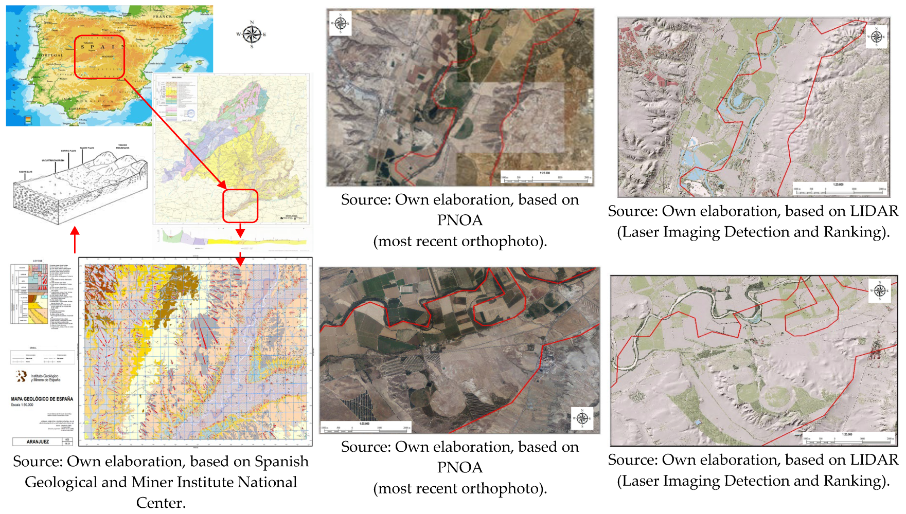
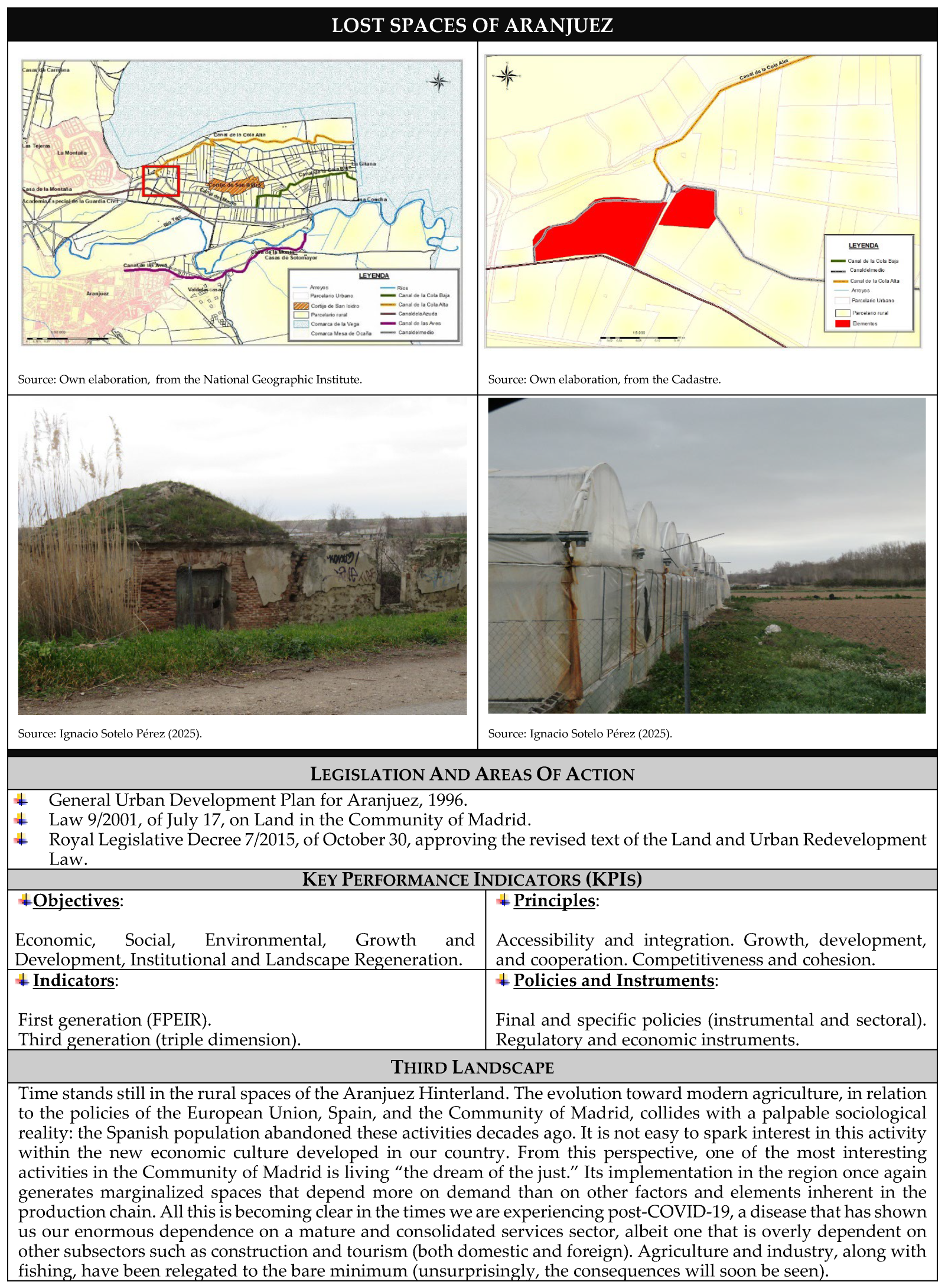
Lost Spaces” (formless and unused anti-spaces) predominate in the geographical space studied (see
Figure 1). In Aranjuez, as in the rest of the cities of Madrid (Spain), urban growth is shaped by the location of housing, particularly in relation to the current industrial crisis. Not only do these housing units, as residential and industrial land, constitute the main component of land use in the process of urban growth, but their predominant role is reinforced by the importance of massive construction in recent decades and its role in the city’s growth itself. In fact, the real estate sector has acquired an importance that can be described as exceptional in its “late”-developing economic system, coupled with the accelerated urban growth that has occurred in cities like Aranjuez [
7]. All of this is accompanied by the inherent problems of housing needs in a model of economic growth that has caused and continues to generate a significant and growing population concentration in cities like the one studied.
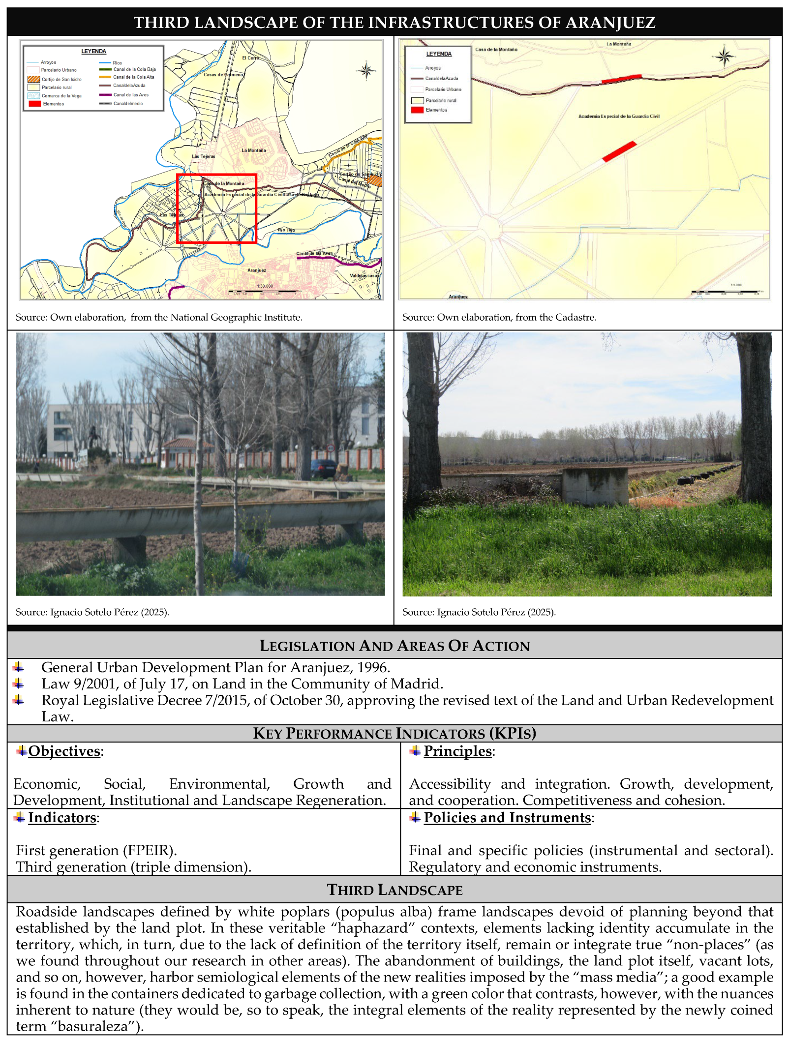
The urban growth of Aranjuez is directly linked to the mechanisms operating in the real estate sector, generating processes resulting from its actions. In fact, when market profitability conditions are not as expected by the real estate sector, the necessary investments will not occur, and urban growth will either not occur or will be generated through other mechanisms. An example of all this is found through the action of public authorities when they directly assume the construction of the city and its areas of influence, or through urbanization processes that we could generically describe as marginal urbanization, related to the reclassification of land (generally industrial) (see
Figure 2).
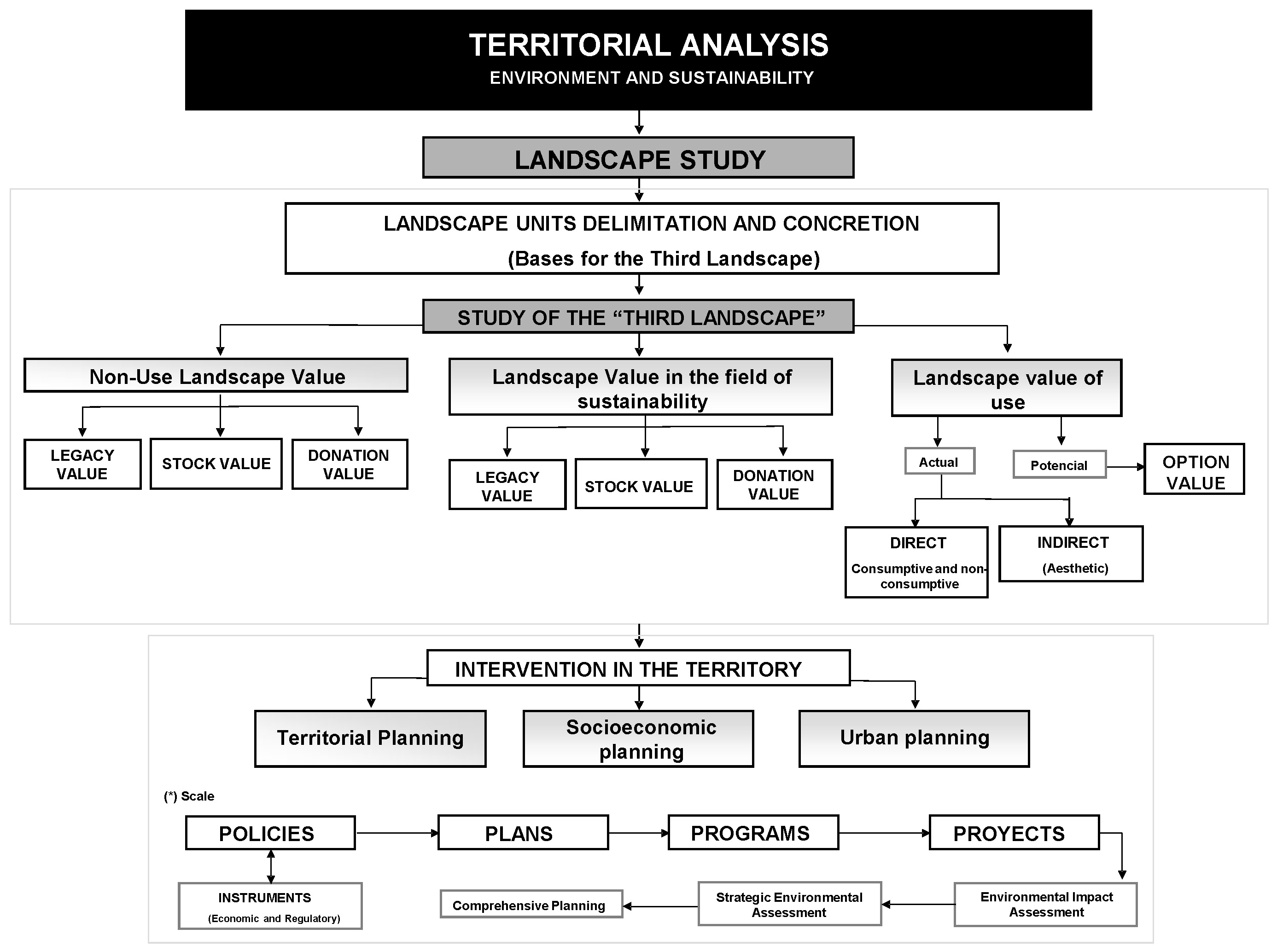
In this way, in order to analyze, assess, and interpret the reality of the “Third Landscape” in the Aranjuez area, it is necessary to understand the geographic space underlying the landscape of the study area. Therefore, this methodology proposes the application of an instrumental basis (quantitative and/or qualitative, as appropriate) that allows for the specification of the landscape units that encompass the so-called “Third Landscape”. Thus, the attached table emphasizes the need to break down the landscape base around the “Non-Use Landscape Value,” which refers to the appreciation that a person or society gives to a landscape simply for its existence, without the need to interact directly with it, that is, a type of intangible value, linked to conservation, cultural identity, and environmental legacy, that includes legacy value, based on the interest in preserving it for future generations; donation value, which shows the value that a person feels when contributing to the conservation of a landscape, even if they do not use it or see it directly; and stock value, which includes the desire for a landscape to continue existing, even if it is never visited. On the other hand, the study of the “Third Landscape” in Aranjuez has been addressed based on the knowledge of “Landscape Value in the Field of Sustainability”, that is, analyzing how the landscapes of Aranjuez contribute to the ecological, economic, and social well-being of the territory, beyond their aesthetic or economic value, integrating the criteria of conservation, resilience, and intergenerational equity. Similarly, and more practically, emphasis has been placed on the “Landscape Use Value”, both current and potential, addressing the direct (consumptive or not), indirect (aesthetic), or optional value of the areas in the territory under study. Our aim is to analyze the value that landscapes or natural environments have for people, not only for what they produce or generate economically but also for how they influence the quality of life of the population (physical and mental health, cultural identity, education and knowledge, aesthetics and enjoyment, etc.). All of this, together with the extensive knowledge of the physical, human, and economic environment, lays the foundations for territorial intervention in the processes of territorial planning, socioeconomic planning, and urban planning, through policies (which define the general framework for action that defines principles, objectives, and priorities on which planning policies are based, whether finalists, specific, sectoral, instrumental, etc.), plans (as a strategic document that organizes actions to comply with a policy), programs (including the set of coordinated actions within a plan, with specific objectives), and projects (which encompass specific action, with defined resources, that executes part of a program). Finally, the methodological analysis uses Key Performance Indicators to analyze the “Third Landscape”, which allows for the objective measurement and/or assessment of the impact, evolution, and value of marginal or residual spaces in a territory, integrating them into sustainability, environmental management, and urban planning strategies, in general, and their application to the study area, in particular.
The consequences of the treatment of the processes collected in the previous figure are that, in the areas where the future growth of Aranjuez will take place, we find a large number of component elements of what Professor Javier Pérez Igualada [
8] qualifies as the “
Third Landscape” (
Lost Spaces,
Shadowed Places,
SLOAPs,
Drosscapes,
Non-place urban realms). These designations, which are added to more generic ones such as vacant land, wasteland, urban voids, or residual spaces, are associated with different readings and assessments of the places they designate, carried out from diverse paradigms—formal, socio-functional, or environmental—, and, also with different proposals for intervention strategies—or non-intervention—in them. In fact, as we can see in the variables comprising the aforementioned methodology in use, the residual spaces that form part of “
Lost Spaces” (formless and unused anti-spaces) predominate in the geographic area of Aranjuez. It is the no-man’s-land along the edges of highways, whose maintenance is unknown, and which no one uses.
3. Results
When dealing with the Third Landscape and the rururban spaces in the south of the Community of Madrid, in the field of sustainability, we must not forget that the interpretation of the spaces of Aranjuez, in particular, is marked by the fact that around the 1930s, Aranjuez would begin to show the first consequences of the absence of urban planning that would allow for the ordering of the various locations of the urban activities that were being developed on its land. The guidelines referring to planning using the orthogonal grid for the urban core of the city of Madrid would be clearly surpassed when, in these years, different individual industrial centers would begin to be located around the area where the city’s railway structure was located. The breakdown of coherence in spatial planning came hand in hand with the absence of a general plan applicable to these circumstances, as the emergence of these industries would not be accompanied by any type of urban planning regulation, which would define the urban relations between them and the industrial centers with the rest of the urban core, developed as the Enlightenment thinkers had designed it.
To this eventual peculiarity, we must add the fact that in the second half of the last century, the growth of the capital of Spain (that is, the city of Madrid), significantly influenced the whole of the province [
9,
10], transforming its structure and morphology and modifying to a certain extent the different professional occupations of a considerable part of its population centers, and thus, the city of Aranjuez was not going to find itself alien to this reality (being eventually absorbed by the influence of the capital, as had already happened to the rural and small centers near the city of Madrid). In fact, to these historical contexts, we can added that in those fifties of the aforementioned century, Aranjuez had primarily agrarian economic functions, mixed with a huge amount of active population dedicated to this agricultural sector and also to the industrial one, which added to the fact that the city lacked adequate urban planning regulations, would reveal the transition from a stage in which the city was governed by an orderly and determined planning, to another stage in which urban and territorial disorder was going to begin to predominate in the urban scene of Aranjuez, which mainly affected the environment surrounding the orthogonal grid, understood as the planning model of the original city.
On the other hand, how can we understand, for example, that in Aranjuez, where everything is living history, the residual spaces we encounter do not express power or submission to power. In the cases discussed, a large number of residual spaces -rural, rururban, urban, industrial, tourist, and other-, are juxtaposed, as could not be otherwise, in cultural spaces. By systematizing the information, we can not only interpret it, but also identify a large number of cause-effect relationships and, more importantly, transform the information into knowledge. All this without forgetting the value of the reality (rural, urban, etc.), in which the spaces are located and developed, the assessment made of them, and the hypothetical actions that can be implemented in them.
The interpretation of place is presented to us as a synthesis of structural forces that generate a reification of space, projecting class interests onto it in accordance with the dominant mode of production. Indeed, space in the capitalist production system is subject to continuous processes of capitalization, contributing to the construction of all physical space as fixed capital. The purpose of the capitalist mode of production is to extend a specific model of social relations to given physical spaces, endowed with underutilized economic content. It should also be noted that, alongside the structural forces that tend to create a territorial model conforming to dominant interests, there are other forces within human beings, more or less developed depending on the degree of alienation, that incite them to assert themselves to seek identity and attachment to places [
11,
12,
13]. Their interrelation generates a resulting force that we can call a “sense of place”, whether positive (
topophilia), negative (
topophobia), or indifferent (
toponegligence).
That is to say, although the evolution of the rural or rural landscape toward sweep and uniformity is a palpable reality, the phenomenon can be interpreted in many ways, as the facts themselves do not originate the interpretation. From this perspective, we distinguish, first, a dominant value system, whose social origin lies in the prevailing institutional order, and it is the moral context that promotes the objectification of space, generating divisions between living, working, and moving around, based on the idea that urban planning is part of the cultural sphere imbued with values that represent the interests of dominant groups, that is, the social segment that benefits the most. The subordinate value system originates in the local community formed by the working class. Its moral context tends to promote accommodating responses, and it lacks institutions that allow it to challenge the dominant value system; its influence is, therefore, very limited.
The sense of place comes from the radical value system, that is, from the values provided by groups that question the institutional basis of capitalism. Thus, whether the dichotomous conception of the forces acting in the elaboration of the image is applied, or the different influences that act on a person or group, the conclusion is that the same place causes different reactions; therefore, it is more appropriate to speak of senses of place and not of places with unique properties for their inhabitants.
Today, in Aranjuez, not only has the capitalist production model become fully established, but it has also been accompanied by the emergence and consolidation of a monopolistic sector (although small businesses still persist within it, not as marginal, but as functional to the overall structure). This implies the dominant position of a social stratum that emerged from, and is closely linked to, financial capital. In point of fact, the transformation of the sector cannot be interpreted solely through market evolution, as it has required the implementation of other mechanisms exogenous to the internal dynamics of the market, with public authorities playing a fundamental role (in our specific case, the Community of Madrid and the Aranjuez City Council, among others).
These have not limited themselves to intervening directly in housing production, but through economic policies [
14], on the one hand, and housing and planning, on the other, they have generated a process marked by the transformation of the way housing is produced, setting the direction for the ways it is consumed. Thus, public powers (the state, the Community of Madrid, the Aranjuez City Council, etc.) have not limited themselves to maintaining a neutral position as managers of the “common good”, but have become directors or, where appropriate, mediators of diverse interests (they have marked both “ex ante” and “ex post” the guidelines that govern the real estate sector) (
Figure 3).
With all this in mind, in Aranjuez, the triad “urban growth–housing policies–transformation of the real estate sector” plays a leading role in the process described, in direct relation to the idea according to which the relative profitability of this sector is based on components not always linked to the production of the product (that is, starting from the financial conditions, they are based, above all, on the possibilities of income emanating from the “land”). Its study and assessment are based on what is known today as territorial analysis, in relation, in this case, to the environment and sustainability, the basis of the applied methodology, which is schematically shown in the following figure (see
Figure 4).
In rural areas, the landscape is defined by a double imprecision: that of the person who perceives and interprets it and that which arises from its continuous change. It is configured as the connection between the environment and the viewer, thus revealing the existence of many landscapes, determined by images created or perceived by individuals, communities, or societies, or those so-called “abstract” landscapes, which have been granted a universal value. From this perspective, the so-called “Third Landscape” is presented as a way of approaching the spatial reality of spaces under “reconstruction,” as is the case in Aranjuez, a city in the Community of Madrid (
Figure 5).
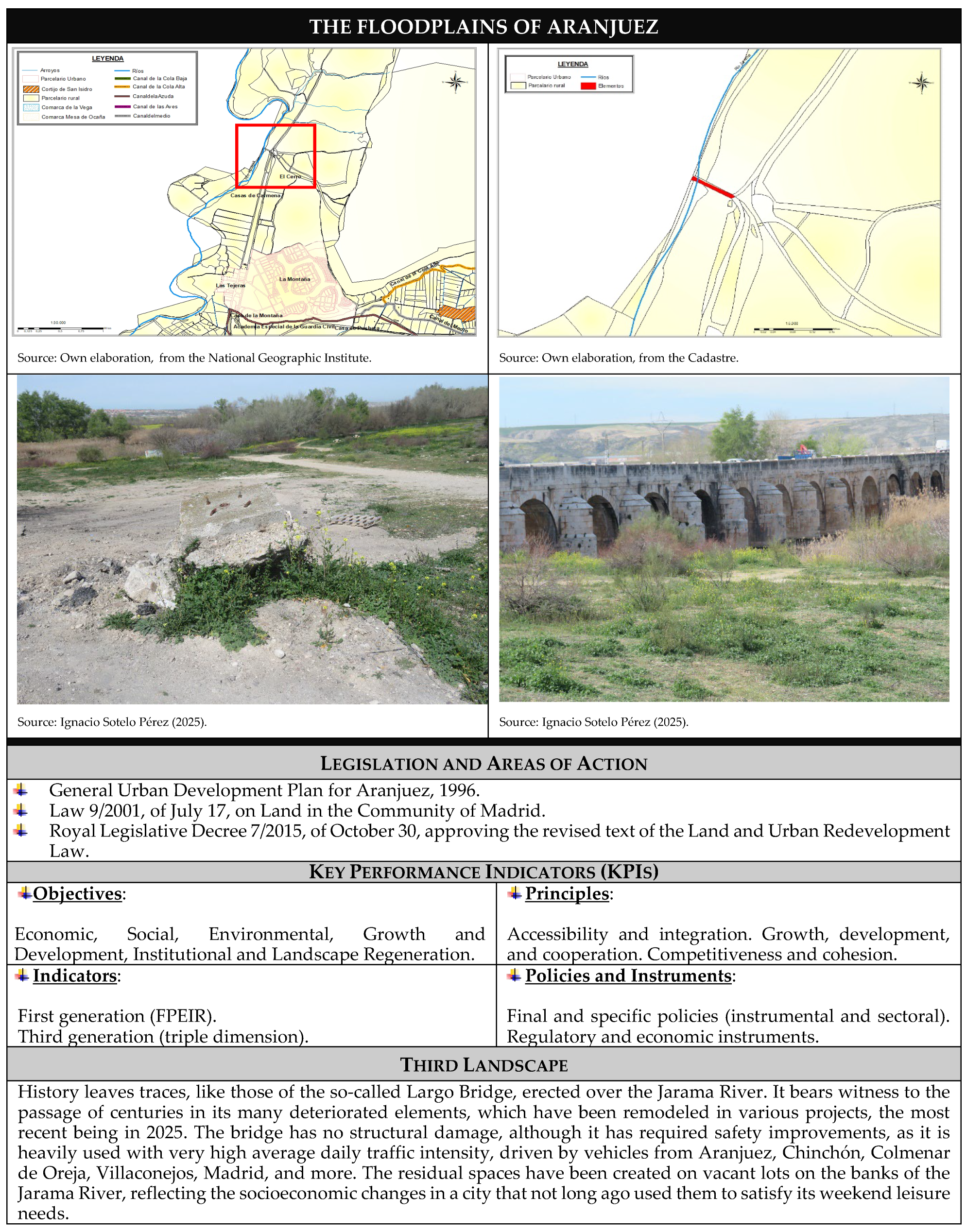
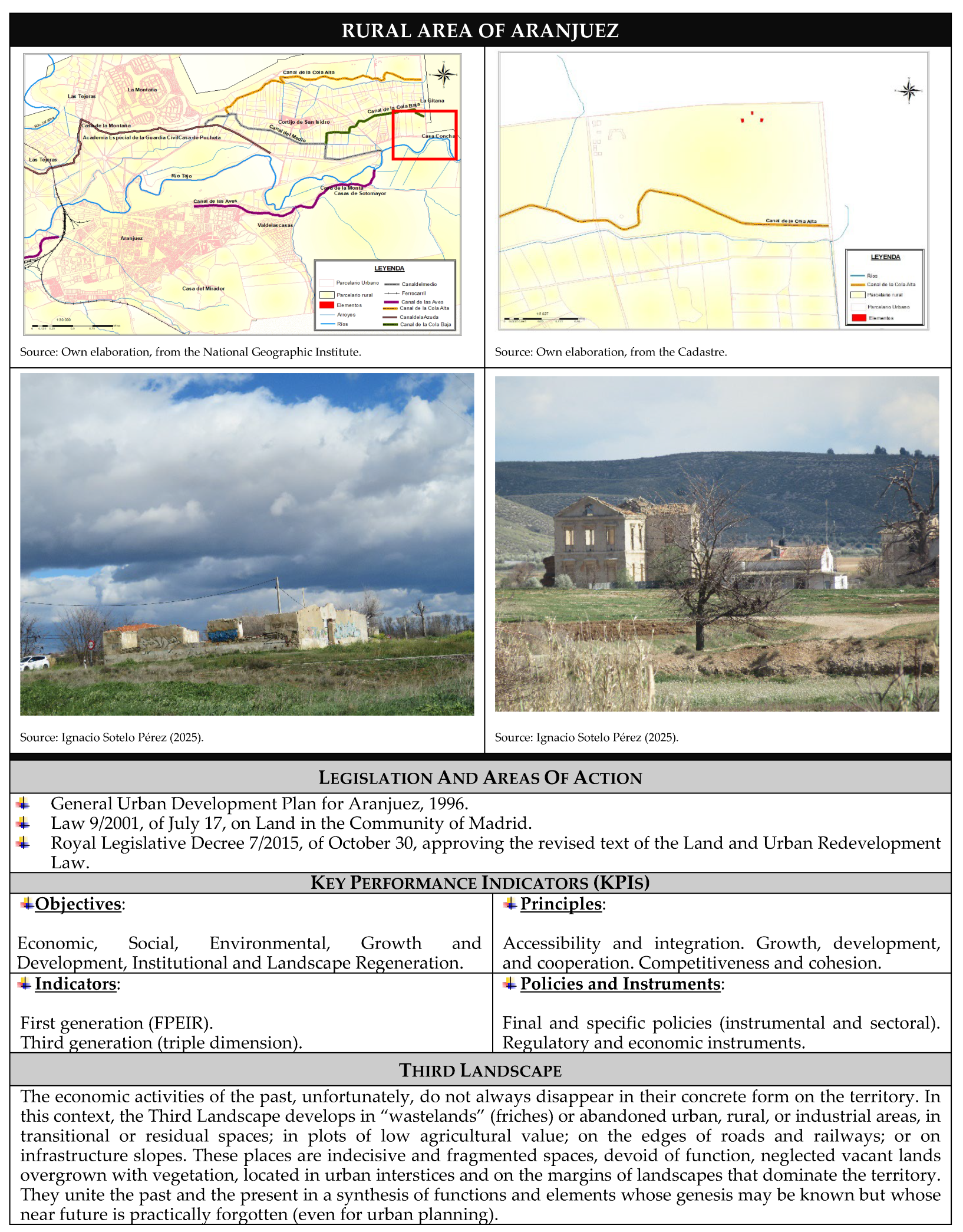
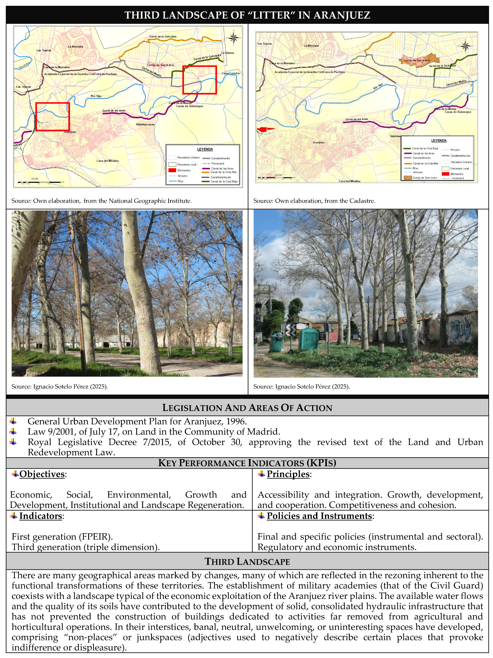
The application of territorial analysis in this case brings us closer to the landscape, along with territorial planning, socioeconomic planning, and urban planning, all in relation to policies, plans, programs, and projects (in short, with the intervention of public authorities in the territory). The methodology applied reveals the existence of spaces such as the railway yards surrounding Aranjuez station, abandoned military compounds, and industrial complexes that have relocated to the suburbs for better access and lower taxes, or have simply disappeared, leaving only the remains of their infrastructure. These are vacant lots in urban centers, resulting from demolitions that, for various reasons, were never rebuilt. They are the residual areas between districts and spontaneous commercial strips that emerge unnoticed, the deteriorating parks and marginal public housing projects that have to be rebuilt because they no longer serve their purpose; in short, the residual spaces of the “Third Landscape”, all of them surrounding or within one of Spain’s most beautiful urban environments. In Aranjuez, a territory where history unfolds like a living fabric, residual spaces emerge as realms that transcend power dynamics and subordination. The cases analyzed reveal a remarkable diversity of these spaces, which inevitably overlap within a complex cultural landscape. All this without forgetting the value of the reality (rural, urban, etc.) in which the spaces are located and developed, the assessment made of them, and the hypothetical actions that can be carried out on them (
Figure 6 and
Figure 7).
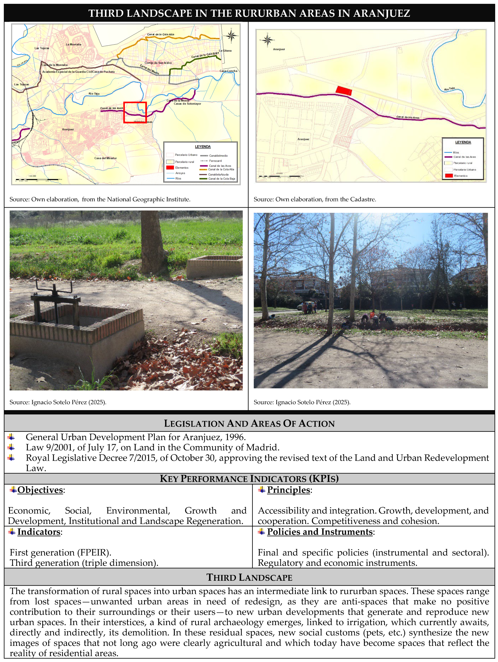
With all them, in the treatment of landscape, the concretization of residual, degraded spaces, whose obsolescence is even programmed by public authorities, directly or indirectly, we can highlight the reiterative nature of a reality that is “constructed”, “deconstructed”, or “destroyed” at each and every scalar level, reproducing itself, almost in the manner of mass production, in diverse, even distant, territories. In fact, the above process is evident in Aranjuez (
Figure 8); we find the capacity to produce homogeneous “places”, where deficiencies are transmuted identically, even simultaneously, throughout the studied territory. This leads to the emergence of unclassified, undefined, and even nameless places. The perceptual factor and, above all, the abstraction and subsequent concretization of these places (in their reiterative nature), fill the geographical space with a void that is complex to define and, above all, to evaluate.
4. Discussion
Following the results achieved above, it can be stated that the processes of transformation of rural areas into spaces where rurbanization and marginal urbanization related to the reclassification of land (generally rural) prevail show a potential increase in recent decades; it is here that a series of transformations and degradations of the geographic spaces of Aranjuez are generated, giving rise to the appearance of a large number of residual spaces, in contrast to, and occasionally as complements to, the formalist landscape. In the highly diffuse world in which we can currently frame the subject related to planning activity in Spain, in general, and in this one, in particular, we can observe a certain conformation toward the interests of the market in this subject. When treated from a more local level, such as that in the town of Aranjuez, it can be confirmed how urban planning is an essential aspect for the proper development and functioning in terms of sustainability of urban centers, and how in the history of Aranjuez, where such planning has not existed, a series of urban planning imbalances and disorders have arisen that are difficult to resolve.
When analyzing urban planning in the history of Aranjuez, it is clear how, during the two and a half centuries of existence of the planned city, it has managed to maintain the urban coherence on which it was created and sustained over the years, and at present, it can be said that the city of Aranjuez is a model for both architectural and urban planning studies; all of this is not without nuances since, if we relate it to capital gains in recent decades, it could be defined as unsustainable and at the same time contrary to the principles of the common good.
At this point, we can affirm that, in the study of the environment and environmental sustainability, the landscape has an important value as a foundation for territorial planning, socioeconomic planning, and urban planning. Its primary role as an intermediary between the natural environment and the people who inhabit it—in their daily and historical activities—makes it the link between humankind and their physical environment. Thus, the landscape is shaped by the integration and interrelationship between the set of factors and elements, both natural and human, that constitute a given territory. It has, therefore, become clear that the arduous task of understanding and interpreting the reality of the territory in relation to development requires approaching new environmental paradigms that make it possible to understand an extremely complex and, above all, changing territorial reality.
In Aranjuez, as in the rest of the cities of Madrid (Spain), urban growth is shaped by the location of housing, particularly in relation to the current industrial crisis. Not only do these housing units, as residential and industrial land, constitute the main component of land occupation in the process of urban growth, but their predominant role is reinforced by the importance gained in recent decades by massive construction and its role in the growth of the city itself, at the expense of rural land and generating rururban landscapes. In fact, the real estate sector has acquired an importance that can be described as exceptional in its “late”-developing economic system, coupled with the accelerated urban growth that has occurred in cities like Aranjuez.
All of this is accompanied by the inherent problems of housing needs in a model of economic growth that caused and continues to generate a significant and growing population concentration in cities like the one studied. We can conclude that the sprawl, or horizontal, extensive, and rapid urbanization of new areas of the city of Aranjuez is taking place on the periphery, linked or closely related to the ongoing phenomena of “de-agrarianization” and “de-industrialization”, processes that disintegrate territories and generate “detritus” in all those sectors of the urban core whose economic and productive activity has ended. This is the case of the residual spaces seen juxtaposed in the previous images; their transformation and readaptation to current times will depend on the economic dynamism of this city. We are faced with the logical outcome, a consequence of the continuous transformation of the environment; that is, one more indicator of healthy urban growth, not a failure. We must not forget that there is no growth without waste, without residue: the urbanized landscape is an open system.
In this way, we can affirm that it is of utmost importance to assess and, above all, reorient the connection between development models and territorial organization models. Thus, it is clear that the development model determines, or at least guides, the territorial model. Evidence of this can be found in the very configuration of spaces undergoing reconversion, such as those in Aranjuez, and the use to which they are put, becoming a faithful reflection of society -and the conflicts it presents-, where any evolution or impact reflects variations or alterations in the scale of social values -ranging from the collective to the individual.
As a point worth noting, in relation to the existing literature on the Third Landscape, the present study aligns itself and critically engages with the thinking of Gilles Clément, author of the
“Third Landscape Manifesto” [
15] (which presents the idea of biodiversity and resilience in unmanaged spaces), providing a contextualized application to the Spanish territory through a geographical and regulatory reading that expands the international theoretical framework. In this way, a detailed analysis of innovative methodological application in the study of landscapes is articulated, incorporating Clement’s vision as the basis of those residual, abandoned, or unplanned spaces that escape direct human control and that, therefore, become refuges of biodiversity and spontaneous expression of the urban system. This vision has been taken up by authors such as Sébastien Marot, who, in
Sub-Urbanism and the Art of Memory (2003) [
16], links these spaces to urban memory and resistance to forgetting; Michel Lussault who, in his studies on urban spatiality, emphasizes the political dimension of emptiness and marginality, as is evident in his publication
L’Homme spatial (2007) [
17]; Ignasi de Solá-Morales i Rubio, who does not directly use the concept of the “Third Landscape”, but whose notion of
“terrain vague” [
18] relates to it, defines empty, abandoned, or unused urban spaces that escape the functional and economic logic of the modern city, considering them places of freedom (thus offering a critical and poetic reading of urban voids as spaces of freedom), which coincides with Clément’s idea of seeing value in the residual, the unplanned, the open to new interpretations; and Philippe Rahm [
19], who approaches urban space from a climatic and sensory perspective that complements the idea of the Third Landscape as a residual and potential space (introducing a sensory and climatic dimension that can transform the perception and use of these spaces). In this way, the present research addresses the study of the Third Landscape from an environmental, economic and social perspective; proposing a territorial reading that incorporates normative, social and ecological variables, which allow reinterpreting the third landscape not only as a biological space, but as a place of cultural significance and symbolic resistance against urban homogenization, as well as against the loss of rural identity and functionality, which expands the proposal of these authors (from the original vision of Clément, Marot, Lussault, etc.) toward a more anthropological and normative dimension.
Furthermore, this study addresses the loss of urban identity in close relation to Kevin Lynch’s arguments in
The Image of the City (1990) [
20], considering citizen perception a key element in shaping the urban landscape. However, this research offers a broader perspective by linking this loss to the effects of urban planning legislation, introducing a legal dimension absent in the works of the aforementioned authors. This integration of territorial regulations with landscape analysis represents a methodological innovation that allows the third landscape to be approached from a more operational and contextualized perspective. However, unlike Clément, Marot, Lussault, Solá-Morales, Rahm, or even Lynch, the present case study is based on the precepts of ecological observation and the aesthetics of abandonment, so that the results of the research give us a more structural vision, supported by case studies and legislative analysis, which may limit the universality of the findings but strengthens their applicability in specific contexts.
In summary, while Clément and other international authors have conceptualized the Third Landscape as a space of biological freedom and aesthetic resistance, this research carries out a reinterpretation as a territorial category that articulates memory, regulations, and ecology, offering a more complex reading, linked to the diverse territorial realities marked by the case study. Thus, it is evident that the results achieved in this research not only align with international principles but also extend to new economic, legal, environmental, and social realities, providing new tools for urban planning and the management of residual landscapes.
From this perspective, by establishing the procedural basis for the treatment of the Third Landscape, in this study using the aforementioned methodology, we have arrived at the intrinsic values of these spaces, specifying their landscape capacity, actual, current, and potential uses, as well as their lack thereof, when applicable. In fact, the adaptation of residual spaces to the reality of Aranjuez, and their elimination when deemed appropriate, is a process underway at present, often linked to the aforementioned speculative ownership, and the not always achieved balance between intervention in the territory by uncorrupted public authorities and the market. In fact, the aforementioned elimination of the aforementioned residual spaces is being proposed through their recycling, although, paraphrasing Professor Pizzetti, “they are a type of waste whose recycling is more difficult, given their immobility and the impossibility of transforming them into something other than space”.
It should also be noted that the 1996 General Urban Development Plan for Aranjuez includes land uses, specifying how the uses affecting land classified as urban land will be regulated in detail through the conditions of use established for each ordinance zone, except in the area delimited as the P.E.R.I. of the “station”. In this regard, developable land and urban land are not regulated in detail, as they are only linked to global uses, which will be developed in the partial planning in detail. Regarding non-developable land, the admissible uses for the defined category are determined at a global level, and the specific uses are conditioned on the urban planning classification, pursuant to the provisions of Article 53 of the Land Law of the Community of Madrid. Furthermore, the residual landscapes of Aranjuez are a serious contrast in one of the most important logistics centers in the Community of Madrid. In the interstices of the rural and rururban landscapes, the facilities themselves are juxtaposed with degraded areas and marginal spaces. Thus, a semiotic mishmash is formed that tourism can only digest through the current messages: sustainability and the environment (in doses more or less acceptable through the market). Not even the once-repopulated areas can hide infrastructures that, after COVID-19, could only be understood by the “Ministry for the Ecological Transition and the Demographic Challenge”, in force in Spain in 2025.
5. Conclusions
From the above, it is clear that the Aranjuez region, recognized for its cultural landscape and declared a World Heritage Site by UNESCO, contains not only historic gardens and monumental spaces but also a network of marginal, interstitial, and residual areas that escape formal planning. These spaces—abandoned riverbanks, undefined urban fringes, agricultural areas in transition, and disused infrastructure—all exhibit the characteristics of the “Third Landscape”, defined as undesigned, spontaneous places that conserve high biodiversity and reflect invisible social and ecological dynamics. From the perspective of landscape value in the field of sustainability, these sites gain relevance not only for their ecological function but also for their capacity to generate human well-being. By applying a methodology that distinguishes between use value (current, potential, direct, and indirect) and non-use value (existence, legacy, and donation), it is evident that these spaces, although not economically exploited, are essential for environmental health, territorial identity, and intergenerational equity. In accord with this, the implementation of Key Performance Indicators (KPIs) allows this qualitative assessment to be translated into objective metrics. Indicators such as the percentage of “Third Landscape” area restored, the biodiversity index, the level of citizen perception, ecological connectivity, and public investment in their development reveal a clear trend toward the progressive degradation of these spaces and their underutilization as a strategic resource. The data obtained through this methodology leads to an unequivocal conclusion: urgent and planned intervention is needed to restore and rehabilitate “Third Landscape” areas in Aranjuez. This intervention should not be limited to ecological restoration but should also integrate social, cultural, and educational uses, recognizing the multiple values these spaces offer to the community.
Ultimately, the “Third Landscape” of Aranjuez is not a territorial void, but a reservoir of opportunities for sustainability, resilience, and landscape innovation. Its restoration is not only desirable, but necessary. From this perspective; agriculture; industry; and, more recently, services in general, and tourism in particular, were the foundation of our country’s economic development for much of the 19th, 20th, and early 21st centuries, until COVID-19 or the war in Ukraine made us miss them. Although it is not easy to solve, climate change; problems with biodiversity; and the search for sustainable development, environmental sustainability, etc., make up a “dust” that takes us back to the mud of the previous images, colloquially speaking. In them, the residual spaces of what is described as industrial archaeology, currently with little or no urban planning protection, make up the “Third Landscape” of Aranjuez.
In this area, we find many rural and rural–urban areas in decline, disappearing, or undergoing transformation. The process of valuing working capital requires controlling an external condition: buildable land, which will be generated by the rezoning of abandoned land. We must not forget that each valuation cycle must begin by “freeing up” land and, in the case of Aranjuez, by rezoning the aforementioned industrial land. The ownership of the same in external areas, and even in some internal areas, of the city, destined to be occupied by urban growth, presents, at the beginning of the process, in an intense way, with a patrimonial character. All this means that the transfers of property, possibly until that moment, were based on inheritances or on purchase–sale operations of rural land; that is, the traffic of the asset was not conditioned, yet, by the expectations created by the future urban use. This is what is known as intermediate natures, that is, unfinished landscapes, in the process of construction. These so-called “intermediate natures” serve to explain the use of obsolete former industrial spaces, as is the case in Aranjuez, whose transformation must be viewed as the result of diverse processes, with consequences that are difficult to calculate.
Finally, it should also be concluded that, in its seemingly simplistic form, the concept of landscape generates a complex reality, a synthesis and symbiosis of a broad amalgam of components—relief, climate, vegetation, population, economic activities, rural, urban, and rururban settlements—which are interrelated, constructing images that are presented to us as “indicators” of a binding and connected relationship between them, the combination of which will ultimately depend on the nature of the various geographical landscapes. We have been able to verify how observing the territory is the starting and ending poin, in an area in which the “perception” resulting from contemplation is shown to be an essential element in the process of abstraction of the biotic, the abiotic, “behavioral” components, etc., in short, the intrinsic character of the territory and the set of signs that enable communication between human beings, their environment, and the rest of the human beings who inhabit it, defining modes of production, relationships, representations, and perceptions and how these give rise to the “Third Landscape”. It is from all this that the search for coherent responses oriented toward the planning and sustainable management of territories marked by territorial organization and development models becomes feasible, based on the idea that different development strategies imply different uses and exploitation of the environment, which translates into the emergence of new organizational models, a true reflection of the projection in said space of economic, social, cultural, environmental policies, etc., whose results we have been able to deal with in the study of the “Third Landscape” and the residual rururban and rural spaces in the south of the Community of Madrid, in general, and Aranjuez, in particular.
