Abstract
Human settlements’ suitability in ecologically fragile regions is critical for sustainable development and ecological security. However, comprehensive assessments that integrate multiple natural environmental factors are insufficient. Here, we establish a human settlements suitability index (HSI) to assess human settlements’ suitability on the Qinghai–Tibet Plateau, including Relief Degree of Land Surface (RDLS), Temperature–Humidity Index (THI), Land Surface Water Abundance Index (LSWAI), and Land Cover Index (LCI). The results show that: (1) The RDLS of the Qinghai–Tibet Plateau was generally high, reflecting elevated terrain and steep topography, with strong regional variation. THI increases from the northwest arid region to the southeast, while high LSWAI and LCI were concentrated and show a zonal distribution. (2) The HSI ranged from 0.07 to 1, with seven suitability types. Low-suitability was distributed in the Kunlun, Gangdise, Himalayas, and the northern and southern parts of the Tibetan valleys. Mid-suitability appeared in the Sichuan–Tibet Alpine Canyon, while high-suitability was concentrated in the northeast (Qaidam Basin, Qilian, Hengduan Mountains), the west (Menyu), and the Qaidam Basin. (3) Low-suitability covered over 70% of the Qinghai–Tibet Plateau but hosts only 20% of the population. Mid-suitability occupied about 20% of the land, yet contained nearly 70% of the population. High-suitability (HSI > 0.7) areas were limited but concentrated populations in the Qaidam Basin, southern Tibetan valleys, and eastern Sichuan–Tibet Alpine Valleys. Future development should target these high-suitability regions to support sustainable population growth and reduce land pressure. These findings provide a scientific basis for regional planning, population distribution, and ecological security on the Qinghai–Tibet Plateau.
1. Introduction
The natural environment of human settlements has an important impact on the development of human society [1,2], and to a certain extent determines the spatial pattern of population distribution. Carrying out a study on the natural suitability assessment of human settlements can not only scientifically reveal the status of human settlements under the influence of natural elements, but also characterize the regional population distribution pattern under natural restrictions or suitability [3]. It also provides decision-making support for population size prediction, population development functional area determination, and sustainable development [4]. Moreover, the Qinghai–Tibet Plateau is the roof of the world, the water tower of Asia, and the third pole of the earth. It is an important ecological security barrier and strategic resource reserve base of ecological pattern in China’s “two screens and three belts”. In the past 10 years, the Qinghai–Tibet Plateau has undergone a series of natural environmental changes under the double intervention of climate change and human activities [5]. Among them, the change in land cover, the tense relationship between man and land caused by the accelerated urbanization process, and the slow change in groundwater resources, all have a great impact on the local human settlements environment, so that continuous and in-depth study is urgently needed [6,7].
At the end of the 19th century, the industrial revolution accelerated the urbanization process in Europe, forcing limited urban space to accommodate a large number of people, which had caused a series of environmental and social problems. In this context, the “Garden City” theory represented by Ebenezer Howard, the “Human Settlement Environment Area” advocated by Patrick Geddes, and the “Human City” represented by Constantinos Apostotos Doxiadis were gradually established. Since then, resource consumption has become more restrictive to social development, and after 1970, human settlements began to focus on sustainable development. The earliest concept of human settlements in the world was put forward in the “Vancouver Declaration”, which defines “human settlements” as a collection of social, material, organizational, spiritual, and cultural elements, including cities, towns, or rural areas, and consists of physical elements that provide support for human activities [8]. All development and creative behaviors are inseparable from the impact of human settlement conditions, so social and economic development must rely on a high-quality human settlement. The international definition of “human settlements” includes a macroscopic framework, including the socio-economic system and the natural environment system. It clarifies the irreplaceable role of natural geographical elements in supporting human settlements, coupled with the extensive attention of the international community to resources and the environment, the importance of natural physical elements to the human settlement environment has gradually become prominent [9,10].
The suitability of human settlements not only directly affects people’s physical and mental health and quality of life, but also indirectly affects the progress of human society and the degree of civilization development, and to a certain extent determines the regional population-economic scale and urbanization level. Therefore, the assessment of the suitability of human settlements is the basis of the study on the carrying capacity of regional resources and environment. There are many natural factors that affect the conditions of human settlements. The most basic and main factors that play a leading role in human settlements include topography, climate, hydrology, vegetation, and other natural elements [11,12]. In the study of human settlements based on the natural environment, domestic and foreign scholars have gradually incorporated topography, soil, climate, water environment, atmospheric environment, and acoustic environment into the influencing factors of human settlements [13]. Taking the natural factors that affect human settlements as the input point, the natural suitability of the human settlements refers to the combined characteristics of the natural environment, such as topographic suitability, climatic suitability, hydrological, and land cover conditions.
International research on sustainable human settlements has accumulated substantial findings, with a core focus on the synergistic relationship between human settlements and the United Nations Sustainable Development Goals (SDGs). In particular, SDG 11 (Sustainable Cities and Communities) and SDG 15 (Life on Land) emphasize that human settlement development in ecologically fragile regions must balance ‘conservation’ and ‘utilization’. The study noted that the restrictive effects of topographic and climatic factors on human settlement suitability are trans-regional phenomena, and localized threshold adjustments are necessary to improve the applicability of assessment models [14]. Additionally, the Global Report on Human Settlements 2022 proposes an ‘ecologically oriented human settlement planning’ framework, highlighting that ecological factors (e.g., hydrology, vegetation) should serve as core indicators for assessing human settlement suitability in high-altitude areas. This framework is highly consistent with the HSI indicator system (incorporating LSWAI and LCI) constructed in this study [15,16]. These international studies not only provide a global reference for assessing human settlement suitability on the Qinghai–Tibet Plateau but also underscore the potential of this study’s findings to inform research in other high-altitude regions (e.g., the southern foothills of the Himalayas, the Alps).
The Qinghai–Tibet Plateau, known as the Third Pole and a typical ecologically fragile region, faces strong natural constraints that influence human settlement patterns. To better understand the current status of human settlements, we constructed a Human Settlements Index (HSI) using high-resolution topographic and meteorological datasets and integrating multiple environmental elements, from single-element analysis to comprehensive synthesis [17]. Unlike previous approaches based on population–physical geography linkages, the key thresholds of settlement suitability in this study are determined by the contribution and influence of individual elements. By combining the HSI with a decision tree stepwise assessment, we scientifically evaluate topographic, climatic, hydrological, and land cover conditions, as well as overall settlement suitability across the plateau [13,18,19]. This study has three aims: (1) to characterize current natural conditions on the Qinghai–Tibet Plateau; (2) to assess the suitability of human settlements, including topographic, climatic, hydrological, and land cover conditions; and (3) to examine the relationship between settlement suitability and population distribution, and to identify areas suitable for future development. These insights are expected to alleviate land pressure and support sustainable regional development on the plateau [8,20].
2. Materials and Methods
2.1. Data
We adopted six types of data, including elevation, meteorological (temperature), hydrological, vegetation, land cover, and population data (Table 1).

Table 1.
The data preparation of the study.
2.1.1. ASTER GDEM Data
This study utilizes Version 2 of the Advanced Spaceborne Thermal Emission and Reflection Radiometer Global Digital Elevation Model (ASTER GDEM)—the first global DEM dataset with a 30 m resolution, covering the latitude range of 83° N to 83° S. The dataset was obtained from the official websites of the Japan Aerospace Exploration Agency (JAXA) and the National Aeronautics and Space Administration (NASA). According to NASA’s official specifications, the horizontal accuracy of this dataset is 30 m (Circular Error, CE90; i.e., 90% of positional errors do not exceed 30 m), and the vertical accuracy is 20 m (95% confidence interval; i.e., 95% of positional errors do not exceed 20 m).
2.1.2. Meteorological Station Data
Meteorological data were obtained from monthly datasets of surface climatological data of meteorological stations over the Qinghai–Tibet Plateau and Central Asian countries from 1980 to 2017 from the China Meteorological Information Center. The monthly value data of each station mainly includes monthly average temperature and monthly average relative humidity, as well as the longitude, latitude, and altitude corresponding to each meteorological station. Moreover, Precipitation data comes from the China Meteorological Information Center as well.
2.1.3. Hydrology and Vegetation Data
The hydrological conditions were described using the Land Surface Water Index (LSWI), while the vegetation situation was assessed with the Normalized Difference Vegetation Index (NDVI). Specifically, the near-infrared (NIR) and short-wave infrared (SWIR) band data needed to calculate the Land Surface Water Index (LSWI) come from the NASA EarthData platform, with a spatial resolution of 1 km and a time scale of month by month. Moreover, the Normalized Difference Vegetation Index (NDVI) data comes from the NASA EarthData platform, with a spatial resolution of 1 km and a time scale of month by month.
2.1.4. Land Cover and Population Density Data
Land cover data were sourced from the “2015 Global 30 m Land Cover Dataset” provided by the National Earth System Science Data Sharing Service Platform. This dataset includes 10 first-level land cover types and adopts the GCS_WGS_1984 projection.
The population data comes from the 2015 LandScan data regularly released by the Oak Ridge National Laboratory, with a spatial resolution of 500 m. The dataset is prepared by collecting authoritative and credible demographic data at the provincial level in various countries, while constructing a weight model based on slope, land cover, etc., calculating the population distribution probability coefficient at the kilometer grid level, and taking the population of each administrative region as the control condition.
2.2. Methods
In this study, the four natural elements of topography, climate, hydrology, and vegetation are first identified as the basis and important components of the comprehensive assessment of the natural suitability of human settlements, and the correlation analysis method is used to reveal the correlation between every two single elements in the study area. Combining field investigation, literature studies, and expert measurement, it is determined that RDLS and THI are the two leading factors in the comprehensive assessment of human settlements, and LSWAI and LCI are auxiliary factors. Finally, through the HSI calculated, the spatial characteristics of human settlements’ suitability in the Qinghai–Tibet Plateau were revealed. Coupled with population density data, the correlation between human settlement suitability and population distribution on the Qinghai–Tibet Plateau was analyzed (Figure 1).
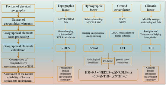
Figure 1.
Technology roadmap.
2.2.1. Relief Degree of Land Surface (RDLS)
Based on the calculation formula of the height difference (Range (H) = Max (H) − Min (H)), batch calculation of N incremental rectangular analysis windows (2 × 2, 3 × 3, …, 120 × 120) by Python 3.10, then calculate the unit terrain degree T in turn.
Ti = ti/si (i = 2, 3, …, 120)
In the formula, Ti is the unit terrain degree under the i-th analysis window, ti is the average height difference, and si is the area of the analysis window. Take the logarithm (lnT) of the unit T sequence from the above calculation to obtain the nonlinear sequence Xk (k = 2, 3, …, 120). Divide the above-mentioned nonlinear sequence Xk into two sections, namely X2, X3, …, Xk and Xk + 1, X60, …, X120, and calculate the arithmetic mean value of the two sections of the sequence (Xk1, Xk2), and the arithmetic mean of the total sample Xk. S − Sk is used to represent the complexity of height difference changes under different analysis windows. The analysis window corresponding to the maximum value of S − Sk can characterize the RDLS under the intact mountain, which is the best analysis window.
Relief Degree of Land Surface (RDLS) is calculated based on the optimal analysis window determined by the above method and its relative height difference. The calculation model is as follows:
RDLS = ALT/1000 + {[Max (H) − Min (H)]} × {[1 − P(A)/A]}/500
In the formula, ALT is the mean elevation within a certain range centered on a grid (m), Max (H) and Min (H) are the highest altitude and the lowest altitude (m) in this area, respectively, P(A) is the area of flat land in the region (km2), and A is the total area of the region. The topographic suitability assessment classification of human settlements based on RDLS is shown in Table 2:
Table 2.
Topographic suitability zoning criteria based on the RDLS in the Qinghai–Tibet Plateau, China.
2.2.2. Temperature–Humidity Index (THI)
The physical meaning of the THI is the temperature after being corrected by the relative humidity, and the influence of temperature and humidity on the comfort of the human body is considered comprehensively.
THI = 1.8t − 0.55 × (1 − f)(1.8t − 26)
In the formula, t is the monthly average temperature (°C) and f is the monthly average relative humidity (%). The grading of climatic suitability assessment for human settlements based on the THI is shown in Table 3:
Table 3.
Climatic suitability zoning criteria based on the THI in the Qinghai–Tibet Plateau, China.
2.2.3. Land Surface Water Abundance Index (LSWAI)
Land Surface Water Abundance Index is used to characterize the abundance level of surface water resources.
LSWAI = α × P + β × LSWI
In the formula, P is the standardized average annual precipitation (mm) and α and β are the weights of the annual average precipitation and LSWI in the study area, respectively. According to the LSWAI model, the value of α is 0.5, and the value of β is 0.5.
2.2.4. Land Cover Index (LCI)
Land Cover Index represents the abundance degree of surface vegetation in the research region.
LCI = NDVI × LTi
In the formula, NDVI is the Normalized Difference Vegetation Index, and LTi is the weight of each land use type. For example, the area around grassland and agricultural land has a higher weight, and the bare land and ice/snow area has a lower weight.
2.2.5. Human Settlements Suitability Index (HSI)
The Human Settlement Suitability Index quantifies the suitability of the study area for human residence under the impacts of natural factors.
HSI = 0.5 × (NRDLS + rh)(NRDLS + rv) + 0.5 × (NTHI + th)(NTHI + tv)
rh = LSWAI × Rth − NRDLS × LSWAI × Rth
rv = LCI × Rtv − NRDLS × LCI × Rtv
th = LSWAI × Rch − NTHI × LSWAI × Rch
tv = LCI × Rcv − NTHI × LCI × Rcv
In the formula, rh is the NRDLS corrected by LSWAI, rv is the NRDLS corrected by LCI, th is the NTHI corrected by LSWAI, and tv is the NTHI corrected by LCI. Rth and Rtv are the correlation coefficients between the RDLS and LSWAI (or LCI) in the study area, respectively, and Rch and Rcv are the correlation coefficients between the THI and LSWAI (or LCI).
2.3. Study Area
The Qinghai–Tibet Plateau starts from the Himalayas in the south, extends to the Kunlun Mountains and Qilian Mountains in the north, borders the Pamirs and the Karakorum Mountains in the west, and connects with the western Qinling Mountains and the Loess Plateau in the east and northeast (Figure 2). Moreover, the boundary data of the Qinghai–Tibet Plateau originates from research projects.
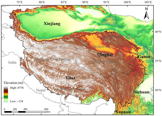
Figure 2.
Map of the Qinghai–Tibet Plateau.
The altitude of the Qinghai–Tibet Plateau is concentrated between 4000 and 5000 m, accounting for half of the total area of its total area, with an average elevation of 4385.51 m. In space, the high altitude areas are concentrated in Ngari, Nagqu, Shigatse, and Qamdo in Tibet, as well as Yushu and Golog in Qinghai. The monthly average temperature in the Qinghai–Tibet Plateau is between −4 and 23.8 °C, with an average temperature of 9 °C. Among them, the cold areas below 0 °C are distributed in the Tanggula Mountains (Geladandong Peak) in the central Qinghai Plateau and the Bayan Har Mountains in the Bayan Har Mountains. The land cover type of the Qinghai–Tibet Plateau is dominated by bare land, supplemented by grassland. Among them, the bare land area of the Qinghai–Tibet Plateau accounts for 52.91% of the total area of the Qinghai–Tibet Plateau, mainly distributed in the Northern Tibet Plateau.
3. Results
This section may be divided by subheadings. It should provide a concise and precise description of the experimental results, their interpretation, as well as the experimental conclusions that can be drawn.
3.1. Topographic Suitability for Human Settlements on the Qinghai–Tibet Plateau
Based on the topographic data of the ASTER GDEM (V2, 30 m), this study uses the mean change point analysis method to determine the best analysis window for the assessment of the RDLS on the Qinghai–Tibet Plateau. Meanwhile, the first 30 m thematic map of RDLS on the Qinghai–Tibet Plateau was drawn. Based on this, the relationship between RDLS, altitude, and relative height difference is analyzed, and the effective representation of RDLS to regional terrain relief is defined. Based on GDEM, the best window for RDLS on the Qinghai–Tibet Plateau is a rectangular neighborhood of 41 × 41 pixels, corresponding to an area of about 1.51 km2. And the mean change point analysis shows that the best window for regional terrain relief has its own uniqueness.
The average RDLS of the Qinghai–Tibet Plateau is about 5.06, and the RDLS of over 3/5 areas is between 4.5~5.7 (Figure 3). On the whole, the RDLS of the Qinghai–Tibet Plateau increases from the northeast to the southwest and west, and only in the Qaidam Basin, the Southern Tibet Valley, and the Hehuang Valley have low undulating landform features. Moreover, the variation in the surface undulation is relatively consistent in different latitude profiles (along the direction of the mountain range), but the level of undulation in different longitude profiles is scattered (transverse to the direction of the mountain range). Correlation analysis shows that different RDLS correspond to geomorphic units with different average elevations and different relative height differences. Based on the profile characteristics of the mountains in the Qinghai–Tibet Plateau under different topographic fluctuations, it is shown that after the low mountains in the Qinghai–Tibet Plateau climbed steadily, they experienced a sudden climb of the mountains and severe surface fluctuations, and finally formed an orderly and scattered ups and downs of extremely high mountains (Himalayas). The topographic suitability of the Qinghai–Tibet Plateau is dominated by critically suitable and unsuitable types, and the corresponding land area accounts for 40% of the total area of the Qinghai–Tibet Plateau. In terms of space, it is distributed in most of Qinghai, most of Tibet, the western section of Kunlun Mountains in Xinjiang, southwestern Qinghai, and western Sichuan.
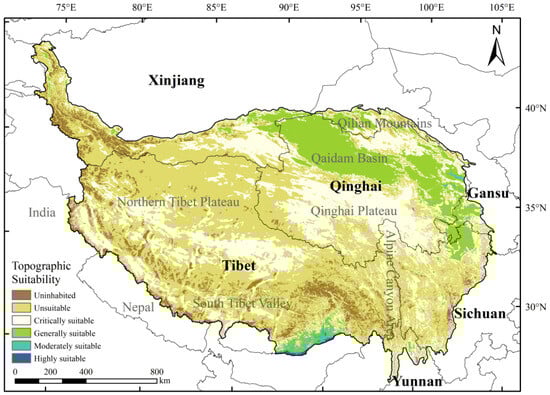
Figure 3.
Spatial distribution of topographic suitability of human settlements in the Qinghai–Tibet Plateau.
3.2. Climatic Suitability of Human Settlements on the Qinghai–Tibet Plateau
Climate is an important factor affecting human activities and settlements environmental. The impact of climate on human settlements is usually expressed by population comfort or climatic suitability, which is based on the principle of heat exchange between human organisms and the near-earth atmosphere, and is a biometeorological indicator of human comfort under different climatic conditions from a meteorological perspective. Climatic suitability not only directly affects the daily life, diseases, and health of various groups of people in the region, but also indirectly affects people’s production and consumption. At present, climatic suitability assessment has become an important component of human settlements assessment.
The calculation results of the THI in the Qinghai–Tibet Plateau show that the human body feels colder, that is, more than 70% of the areas have a THI < 55, and the colder and more comfortable areas with a THI between 45 and 55 account for 35.82% of the total land area of the Qinghai–Tibet Plateau. In addition, the fresh and warm areas with a THI between 55 and 70 occupy about 30% of the Qinghai–Tibet Plateau, and the hot areas on the Qinghai–Tibet Plateau accounted for only 0.31%. Correspondingly, the monthly average temperature of the Qinghai–Tibet Plateau is 9 °C, and the human body feels relatively cool and refreshing; the average relative humidity in this area is 53.3%, and the relative humidity in the area exceeding 50% is between 48~64%. The results of the climatic suitability assessment based on the THI show that the human body feels relatively cool in the Qinghai–Tibet Plateau, and the spatial differences in the climatic suitability zones are obvious. The Qinghai–Tibet Plateau is dominated by the critically suitable type of climate, the corresponding land area accounts for about 60%, and the corresponding population accounts for 30%. In space, the boundary of the climatic suitability between the unsuitable type and the critically suitable type is as follows: Karakoram Mountains—Gangdise Mountains—Nianqing Tanggula Mountains—Tanggula Mountains.
The spatial distribution of climatic suitability types on the Qinghai–Tibet Plateau is relatively “uniform”, among which the critically suitable, moderately suitable, and highly suitable areas account for more than 20% of the area on the Qinghai–Tibet Plateau (Figure 4). Generally, suitable areas also account for nearly 20% of the area of the Qinghai–Tibet Plateau, while climatically unsuitable areas account for about 10% of the Qinghai–Tibet Plateau. The above assessment results are greatly affected by the data processing and calculation principles of the assessment indicators. Judging from the temperature interpolation results, 30% of the Qinghai–Tibet Plateau is a cold area, but the relative humidity in this area is generally high. The THI assessment results indicate that most areas belong to cold or slightly colder climates. Similarly, the average annual temperature on the Qinghai–Tibet Plateau is generally low, and there are no high-temperature zones. Furthermore, after relative humidity correction, most of the rain-filled areas in Sichuan–Tibet (such as Linzhi) were judged to be a moderately suitable type. Therefore, the climatic suitability of the Qinghai–Tibet Plateau evaluated with the THI as an indicator shows that more than 60% of the Qinghai–Tibet Plateau is a suitable type.
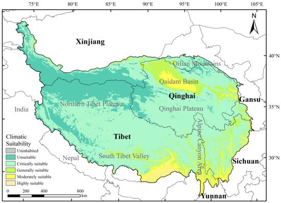
Figure 4.
Spatial distribution of climatic suitability of human settlements in the Qinghai–Tibet Plateau.
3.3. Hydrology and Vegetation Conditions of Human Settlements on the Qinghai–Tibet Plateau
Water is one of the most basic material conditions for human survival and production activities. In addition to directly providing water for human life in urban and rural areas, industry and agriculture, it also indirectly supports the earth’s life system on which human beings rely for survival and development. The impact of hydrological conditions on human settlements is usually characterized by LSWAI, and the correlation between regional water resources, hydrological conditions, and population distribution is analyzed. The spatial distribution of the LSWAI on the Qinghai–Tibet Plateau is significantly different, with the LSWAI ranging from 0.02 to 0.75 and the average value of 0.2. Among them, areas with scarce surface water resources (LSWAI < 0.2) are mainly distributed in the Bayankhara Mountains, the Qinghai Plateau, and the eastern foothills of the Himalayas. Areas with balanced surface water resources (LSWAI between 0.2 and 0.4) are mainly distributed in the south of the Tanggula Mountains, the Sichuan–Tibet alpine valleys, and the Karakoram–Gangdise Mountains. Areas rich in water resources (LSWAI > 0.6) are mainly distributed in the northern part of the southern Tibet valley (Figure 5a).

Figure 5.
Spatial distribution of LSWAI and LCI in the Qinghai–Tibet Plateau. Note: (a) the LSWAI in the Qinghai–Tibet Plateau, (b) the LCI in the Qinghai–Tibet Plateau.
The impact of land cover conditions on human settlements is usually represented by LCI. Focusing on the differences in the expression of vegetation coverage in the surface space of the Qinghai–Tibet Plateau, this study uses the LCI to characterize the regional vegetation coverage and the primary productivity of green vegetation. Based on this, the correlation between regional vegetation resources, land cover conditions, and population distribution is analyzed. The former reflects the degree of impact of human activities on natural resources, while the latter characterizes regional vegetation coverage and primary productivity of green plants. The results show that the ground cover conditions in the Qinghai–Tibet Plateau are relatively poor, and large areas in the northwest of the Qinghai–Tibet Plateau are all bare land, ice and snow, and impermeable layers, while these types of vegetation cover account for 70% of the total area of the Qinghai–Tibet Plateau. However, the population is concentrated in areas where the LCI is between 0.1 and 0.2, and the land cover conditions have little effect on the adjustment of residential conditions; in high vegetation coverage areas where the LCI is greater than 0.6, the proportion of the population is only about 3%. Most of the areas with high values of LCI are located near the Sichuan–Tibet alpine valley area (Figure 5b).
Based on the analysis of the hydrological conditions and ground cover conditions of the human settlements on the Qinghai–Tibet Plateau, that can intuitively recognize the characteristics of hydrology and ground cover in different spaces, and use the hydrological elements and ground cover elements as auxiliary adjustment factors for the comprehensive assessment of human settlements’ suitability. That is to say, in the construction of the human settlements suitability model, the high value area of the LSWAI and the LCI will positively adjust the suitability of the human settlements.
3.4. Human Settlements Suitability on the Qinghai–Tibet Plateau
3.4.1. Spatial Patterns of NRDLS and NTHI with Auxiliary Factors
In the Qaidam Basin in the northeast of the Qinghai–Tibet Plateau, the Yellow River Basin in Gansu Province, and the Menyu area in the west of the Qinghai–Tibet Plateau, the value of RDLS after corrected by auxiliary factors is still relatively high, which expressed as high altitude, relatively gentle terrain relief, with little influence of hydrology and ground cover factors (Figure 6a). However, the NRDLS values in the Kunlun Mountains, Gangdise Mountains, and Himalayas are still low, which is expressed by high altitude, large terrain fluctuations, and little influence of hydrological and land cover factors. Moreover, the NRDLS value of the vast northern Tibetan plateau and southern Tibetan valley is lower, due to the limitation of ground cover and hydrological conditions, where it is mostly bare land, ice, and snow, and the average annual precipitation is low, which is expressed by high altitude and large terrain fluctuations.

Figure 6.
Spatial patterns of NRDLS and NTHI with auxiliary factor on the Qinghai–Tibet Plateau. Note: (a) the NRDLS in the Qinghai–Tibet Plateau, (b) the NTHI in the Qinghai–Tibet Plateau.
In the Qaidam Basin, the Qilian Mountains and Hengduan Mountains in the northeast of the Qinghai–Tibet Plateau, and the Menyu in the west of the Qinghai–Tibet Plateau, the NTHI values are still high after the adjustment of co-factors. It is expressed as higher temperature and relative humidity, and little influence of hydrological and land cover factors (Figure 6b). However, the NTHI values in the Kunlun Mountains, the Gangdise Mountains, and the west side of the Himalayas are still low, which is expressed by the low temperature and relative humidity, and the small influence of hydrological and land cover factors. While the NTHI values in the northern Tibetan Plateau, southern Tibetan Valley, Qinghai Plateau, and Sichuan–Tibet Alpine Canyon Area are reduced. Restricted by ground cover and hydrological conditions, this region is mostly bare land, snow, and ice, and the average annual precipitation is low, which is expressed as a large annual change in temperature and relative humidity, and the influence of hydrological and ground cover factors (Figure 6b).
3.4.2. Relationship Between Human Settlements Index and Single Element Index
The linkage relationship between the results of the HSI and the four types of single elements is shown in Figure 7: the HSI is positively correlated with the NRDLS and shows an increasing trend. In the calculation of the model, the RDLS is normalized to the minimum value, resulting in a small number of low-value intervals of the value and poor regularity in the distribution of HSI. At the same time, the low value of the NTHI in this interval is a combination of alpine climates. That is, when the value of HSI is between 0 and 0.2, the values of NRDLS and NTHI are both between 0.1 and 0.5, while the LCI has little influence on the positive effect of HIS. Relatively speaking, the LSWAI contributes more to the correction of the dominant factor. Combined with the geographical spatial distribution characteristics, the regions with low NRDLS are mainly located in the Kunlun Mountains, the Northern Tibet Plateau, the Gangdise Mountains, and the Himalayas, which are dominated by bare land and deserts, and the spatial distribution of surface water resources varies greatly. The same is true for NTHI.
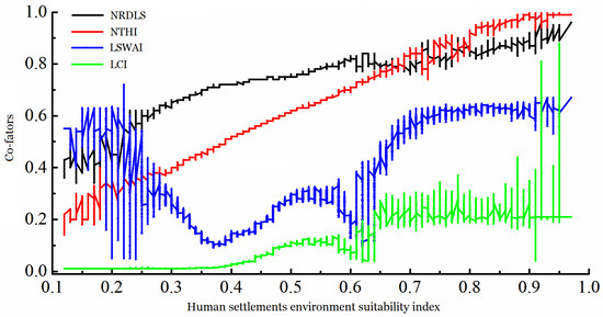
Figure 7.
Relationship between HSI and single element index (NRDLS, NTHI, LSWAI, and LCI).
While HSI is between 0.2~0.4, the NRDLS and the NTHI both show an increasing trend (Figure 7), and the LSWAI has a low value (for example, the northern Tibet Plateau, the Gangdise Mountains, Qilian Mountains, and other places), while the LCI changes little. When the value of HSI is between 0.4~0.6, the NRDLS and the NTHI increase and decrease interactively; the former has a greater impact on the positive effect of HSI, and the enhanced correction of LSWAI and LCI begin to unfold. Specifically, it is the Sichuan–Tibet Alpine Valley Area, which has a high degree of ground cover and rich surface water resources. After the value of HSI is greater than 0.6, the NRDLS is almost unchanged, and the fluctuation of LSWAI increases and changes. The increase in HSI value is caused by the linear increase in NTHI and the correction of LCI. Specifically, it is the slow-moving areas such as the valleys in southern Tibet and the vicinity of the Qaidam Basin. When the value of HSI is greater than 0.9, the LCI suddenly increases to above 0.3, and the increase in HSI value is corrected by hydrological and ground cover conditions.
3.4.3. Spatial Relationship Between HSI and Population
About 20% of the population of the Qinghai–Tibet Plateau is distributed in areas with an HSI < 0.5, but the corresponding area accounts for more than 70% of the total area of the Qinghai–Tibet Plateau, where the terrain is violently undulating, the temperature is low, and the humidity is low (Figure 8). In space, it is mainly distributed in most areas such as the Kunlun Mountains, the western Himalayas, and the northern Tibetan Plateau. Nearly 70% of the population on the Qinghai–Tibet Plateau is distributed in areas with an HSI between 0.5 and 0.7, but the corresponding land area accounts for about 20% of the Qinghai–Tibet Plateau (Figure 9). In addition to constraints imposed by natural factors, the “population-suitability mismatch” phenomenon is closely associated with non-natural drivers. First, regions with an HSI of 0.5–0.7 (e.g., the Southern Qinghai Plateau and the Sichuan–Tibet Alpine Gorge Region) possess relatively well-developed infrastructure (e.g., towns along the Qinghai–Tibet Railway and Sichuan–Tibet Highway) and concentrated medical and educational resources, which act as key attractors for population aggregation. Second, these regions have established a mature local economic system driven by grassland animal husbandry and characteristic tourism, providing stable employment opportunities that further reinforce population retention. Third, historical settlement traditions (e.g., the distribution of traditional Tibetan nomadic settlements) have shaped a stable population distribution pattern in these areas, which is unlikely to shift rapidly in response to changes in natural suitability in the short term. In contrast, regions with an HSI < 0.5 (e.g., the Kunlun Mountains and the Northern Tibet Plateau) suffer from underdeveloped economies and inadequate infrastructure. Even if minor improvements in natural conditions occur in these areas, they remain unable to attract significant population inflows in the near term.
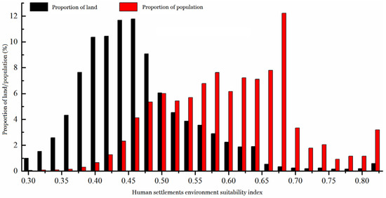
Figure 8.
Statistical analysis of HSI and population on the Qinghai–Tibet Plateau.

Figure 9.
Spatial zoning of human settlements suitability in the Qinghai–Tibet Plateau.
Based on the linkage analysis results of HSI and four auxiliary factors, while combined with the intuitive understanding of the field investigation in Tibet, finally, according to the natural break point method, the suitability of human settlements on the Qinghai–Tibet Plateau is divided into seven types (Table 4), namely, permanent unsuitable (0 < HSS < 0.32), conditional unsuitable (0.32 < HSS < 0.41), restrictive-critical suitable (0.41 < HSS < 0.45), critically suitable (0.45 < HSS < 0.52), generally suitable (0.52 < HSS < 0.61), moderately suitable (0.61< HSS < 0.81), and highly suitable (HSS > 0.81). The assessment results showed that the areas with the unsuitable type of human settlements account for 32.48% of the Qinghai–Tibet Plateau, and the corresponding population accounts for only 1.87%. They are mainly distributed in the Kunlun Mountains and the Gangdise Mountains. Areas suitable for human settlements account for 18.99% of the Qinghai–Tibet Plateau, and the corresponding population accounts for 74.18%. They are mainly distributed in the Qaidam Basin, the Minjiang River Basin in Sichuan, and the Menyu area on the south side of the Qinghai–Tibet Plateau.
Table 4.
Zoning for human settlements suitability based on HSI in the Qinghai–Tibet Plateau.
4. Discussion
This study utilizes products such as terrain, climate, hydrology, vegetation, land use/cover, and population distribution with longer time series and higher data quality, from single element to multi-element, from classification to synthesis, and objectively defines the assessment window and scientifically determines the key threshold of suitability partition, and establishes the human settlement index model. And comprehensively use the HSI method and the step-by-step judgment method to scientifically and reasonably assess the topographic suitability, climatic suitability, hydrological/ground cover conditions, and the comprehensive suitability of human settlements on the Qinghai–Tibet Plateau.
As the “third pole” of the earth, the Qinghai–Tibet Plateau has a towering and undulating terrain with a dry climate, thin air, strong solar radiation, and low temperature, where the conditions of hydrology, vegetation, and land use/cover are significantly affected by both climate change and human activities [21,22]. Since 2008, new data products (such as DEM products from SRTM to ASTER GDEM) have not only given birth to new study methods, but also called for new methods and their experimental study. Compared with prior studies on the Qinghai–Tibet Plateau, this study determined an optimal analysis window of 41 × 41 pixels (corresponding to an area of approximately 1.51 km2) using the mean change point method [13,18]. This window size better accommodates the large-scale undulating terrain of the Qinghai–Tibet Plateau, enabling more accurate characterization of regional topographic differences and thereby enhancing the explanatory power of RDLS for human settlements’ suitability.
The existing dataset exhibits two key limitations. First, the population data rely on the 2015 Landscan global population dataset, which fails to account for dynamic population changes post-2015—including those driven by urbanization and ecological migration policies on the Qinghai–Tibet Plateau. This omission may lead to an underestimation of the population-carrying capacity of highly suitable areas. Second, the temporal scope of the climatic data does not include the impacts of extreme climate events post-2018 (e.g., extreme precipitation in the Qinghai Lake Basin in 2022) on hydrological and vegetation conditions. Feasible strategies for future improvements are proposed as follows: (1) Acquire updated 2020 Landscan data and local statistical yearbooks to correct for the effects of population dynamics; (2) Leverage continuous atmospheric pressure data (post-2018) from 58 national meteorological stations on the Qinghai–Tibet Plateau (e.g., Lhasa and Golmud stations), combined with Kriging interpolation, to generate high-resolution spatial distribution data of oxygen content, thereby refining the HSI indicator system; (3) Introduce machine learning algorithms (e.g., random forest) to optimize the weight assignment of each factor, reducing subjective biases in the model [23,24].
Moreover, this study utilizes climatic data spanning 2008–2017 and land cover data from 2015, it is important to note that against the backdrop of intensified climate change post-2018, the Qinghai–Tibet Plateau has experienced prominent environmental changes, including accelerated glacial retreat (e.g., increased retreat rates of glaciers in the Nyainqêntanglha Mountains) and grassland degradation (e.g., elevated grassland desertification rates in the Three-River-Source Region) [25,26]. These changes may lead to a reduction in the Land Surface Water Abundance Index (LSWAI) and fluctuations in the Land Cover Index (LCI), thereby compromising the timeliness of the Human Settlements Index (HSI) assessment results. Future research should integrate long-term sequential data from post-2018 to verify the temporal stability of the proposed model and enhance the utility of assessment results for supporting recent regional planning initiatives [27,28].
However, the HSI system constructed in this study is not a “comprehensive assessment method” but rather a “natural factor-oriented analytical framework” tailored for human settlement suitability assessment on the Qinghai–Tibet Plateau. This framework lays a critical foundation for future interdisciplinary research that integrates social and economic factors (e.g., per capita GDP, public service facility density). The HSI assessment system developed in this study holds reference value for other ecologically fragile high-altitude regions worldwide. For example, in regions such as the southern foothills of the Himalayas (Nepal, Bhutan) and the central Andes Mountains (Peru, Bolivia), the system can be adapted for local human settlement suitability assessments by optimizing indicator parameters to reflect regional natural characteristics—such as adjusting the Temperature Humidity Index (THI) threshold for the arid climate of the Andes or modifying the LSWAI weight to account for high precipitation at the southern foothills of the Himalayas [10,14]. Furthermore, the study’s findings can be integrated with existing regional sustainable development frameworks: (1) the results align with the requirement of “appropriate population concentration and ecological priority” outlined in China’s Qinghai–Tibet Plateau Ecological Security Barrier Construction Plan (2021–2035), providing a scientific basis for urbanization planning in highly suitable areas; (2) it can connect to the “ecological adaptation in high-altitude regions” agenda under the United Nations Framework Convention on Climate Change (UNFCCC), offering a Chinese case study for promoting the coordinated development of human settlements and ecology in high-altitude regions globally [29,30].
5. Conclusions
This study establishes a comprehensive assessment system of human settlements suitability Index (HSI) on the Qinghai–Tibet Plateau, integrating four natural elements: Relief Degree of Land Surface (RDLS), Temperature–Humidity Index (THI), Land Surface Water Abundance Index (LSWAI), and Land Cover Index (LCI). We found that the Qinghai–Tibet Plateau is characterized by high elevation and strong terrain undulation, with relatively flat areas mainly in the Qaidam Basin, southern Tibetan valleys, and Hehuang Valley. The climate is generally cold, with suitable areas accounting for about 60% and a relatively uniform spatial distribution. Hydrology and land cover vary considerably, and high-value areas can positively enhance settlement suitability.
HSI values range from 0.07 to 1 (mean 0.45), generally increasing from the northeast and southwest toward the central plateau. In space, the value of HSI increases gradually from the northeast and southwest to the middle of the study area. The contributions of NRDLS and NTHI to the HSI show a linkage change of “one declines and the other grows”. In addition, low-suitability (HSI < 0.5) cover over 70% of the land but host only ~20% of the population, mainly in the Kunlun Mountains, western Himalayas, and northern plateau; mid-suitability (HSI 0.5–0.7) occupy ~20% of the land and contain ~70% of the population in the Nianqing Tanggula Mountains and Qinghai Plateau; high-suitability (HSI > 0.7) are limited (~1.5% of land, 10% of population) and concentrated in the Qaidam Basin, southern Tibetan valleys, and eastern Sichuan–Tibet Alpine Valleys. Overall, unsuitable areas cover 32.48% of the plateau with 1.87% of the population, while suitable areas account for 18.99% of the land and host 74.18%, mainly in the Qaidam Basin, Minjiang River Basin, and Menyu region. Our findings highlight the strong influence of natural environmental constraints on human settlement distribution and provide a scientific basis for sustainable regional planning on the Qinghai–Tibet Plateau.
Author Contributions
Writing—original draft, W.L. and F.F.; Writing—review & editing, W.L.; Visualization, X.S. and Y.T.; Supervision, X.S. and Y.T. All authors have read and agreed to the published version of the manuscript.
Funding
This research was funded by the Natural Science Foundation of China (No. 4240010239). And The APC was funded by the Ecological Technical Research Institute, China International Engineering Consulting Corporation.
Data Availability Statement
Openly available data is accompanied by data source links in the manuscript, while confidential data cannot be shared as stipulated by the confidentiality agreement.
Conflicts of Interest
Xiao Shi and Yu Tian are employed by China International Engineering Consulting Corporation. The authors declare no conflict of interest.
References
- Al-Kofahi, S.D.; Gharaibeh, A.A.; Bsoul, E.Y.; Othman, Y.A.; St Hilaire, R. Investigating domestic gardens’ densities, spatial distribution and types among city districts. Urban Ecosyst. 2019, 22, 567–581. [Google Scholar] [CrossRef]
- Chen, S.T.; Xing, Y.W.; Su, T.; Zhou, Z.K.; Dilcher, E.D.L.; Soltis, D.E. Phylogeographic analysis reveals significant spatial genetic structure of Incarvillea sinensis as a product of mountain building. BMC Plant Biol. 2012, 12, 58. [Google Scholar] [CrossRef] [PubMed]
- Immerzeel, W.W.; van Beek, L.P.H.; Bierkens, M.F.P. Climate Change Will Affect the Asian Water Towers. Science 2010, 328, 1382–1385. [Google Scholar] [CrossRef] [PubMed]
- Wang, M.; Yan, J.; Wang, R. Ecological engineering for water in sustainable settlements construction. Int. J. Sustain. Dev. World Ecol. 2007, 14, 556–564. [Google Scholar] [CrossRef]
- Sami, K. The Interaction of Environment, Space and the Human Being in Rural Alevi Culture-The Case of Two Villages. Bilig 2013, 67, 169–194. [Google Scholar] [CrossRef]
- Chen, T.; Jiao, J.; Wei, W.; Li, J.; Zhang, Z.; Yang, H.; Ma, H. Spatiotemporal variation in the land use/cover of alluvial fans in Lhasa River Basin, Qinghai–Tibet Plateau. Agriculture 2023, 13, 312. [Google Scholar] [CrossRef]
- Hu, C.; Zhang, M.; Huang, G.; Li, Z.; Sun, Y.; Zhao, J. Tracking the impact of the land cover change on the spatial-temporal distribution of the thermal comfort: Insights from the Qinhuai River Basin, China. Sustain. Cities Soc. 2024, 116, 105916. [Google Scholar] [CrossRef]
- Tang, L.; Ruth, M.; He, Q.; Mirzaee, S. Comprehensive evaluation of trends in human settlements quality changes and spatial differentiation characteristics of 35 Chinese major cities. Habitat Int. 2017, 70, 81–90. [Google Scholar] [CrossRef]
- An, Q.; Yuan, X.; Zhang, X.; Yang, Y.; Chen, J.; An, J. Spatio-temporal interaction and constraint effects between ecosystem services and human activity intensity in Shaanxi Province, China. Ecol. Indic. 2024, 160, 111937. [Google Scholar] [CrossRef]
- Chen, Y.; Ge, Y.; Yang, G.; Wu, Z.; Du, Y.; Mao, F.; Liu, S.; Xu, R.; Qu, Z.; Xu, B.; et al. Inequalities of urban green space area and ecosystem services along urban center-edge gradients. Landsc. Urban Plan. 2022, 217, 104266. [Google Scholar] [CrossRef]
- Luo, X.; Yang, J.; Sun, W.; He, B. Suitability of human settlements in mountainous areas from the perspective of ventilation: A case study of the main urban area of Chongqing. J. Clean. Prod. 2021, 310, 127467. [Google Scholar] [CrossRef]
- Xiao, Y.; Li, Y.; Tang, X.; Huang, H.; Wang, R. Assessing spatial–temporal evolution and key factors of urban livability in arid zone: The case study of the Loess Plateau, China. Ecol. Indic. 2022, 140, 108995. [Google Scholar] [CrossRef]
- Wang, Y.; Jin, C.; Lu, M.; Lu, Y. Assessing the suitability of regional human settlements environment from a different preferences perspective: A case study of Zhejiang Province, China. Habitat Int. 2017, 70, 1–12. [Google Scholar] [CrossRef]
- Guo, S.S.; Wu, C.Y.; Wang, Y.H.; Qiu, G.; Zhu, D.; Niu, Q.; Qin, L. Threshold effect of ecosystem services in response to climate change, human activity and landscape pattern in the upper and middle Yellow River of China. Ecol. Indic. 2022, 136, 108603. [Google Scholar] [CrossRef]
- Zhang, M.; Tan, S.; Zhang, C.; Han, S.; Zou, S.; Chen, E. Assessing the impact of fractional vegetation cover on urban thermal environment: A case study of Hangzhou, China. Sustain. Cities Soc. 2023, 96, 104663. [Google Scholar] [CrossRef]
- Zhao, Y.; Zhang, J.L. The Natural Suitability of Human Settlements and Their Spatial Differentiation in the Nenjiang River Basin, China. Front. Environ. Sci. 2022, 10, 861027. [Google Scholar] [CrossRef]
- Liu, H.; Fan, J.; Zhou, K.; Xu, X.; Zhang, H.; Guo, R.; Chen, S. Assessing the dynamics of human activity intensity and its natural and socioeconomic determinants in Qinghai–Tibet Plateau. Geogr. Sustain. 2023, 4, 294–304. [Google Scholar] [CrossRef]
- Feng, Z.; Tang, Y.; Yang, Y.; Zhang, D. Relief degree of land surface and its influence on population distribution in China. J. Geogr. Sci. 2008, 18, 237–246. [Google Scholar] [CrossRef]
- Zhu, R.; Jiang, Y.; Wang, B.; Zhang, Y. Changes in human settlement environments and their drivers in valley cities located in arid and semi-arid regions: A case study of Lanzhou in western China. Res. Cold Arid. Reg. 2024, 16, 149–158. [Google Scholar] [CrossRef]
- Ding, Y.; Shi, B.; Su, G.; Li, Q.; Meng, J.; Jiang, Y.; Qin, Y.; Dai, L.; Song, S. Assessing suitability of human settlements in high-altitude area using a comprehensive index method: A case study of Tibet, China. Sustainability 2021, 13, 1485. [Google Scholar] [CrossRef]
- An, S.; Zhu, X.L.; Shen, M.G.; Wang, Y.F.; Cao, R.; Chen, X.; Yang, W.; Chen, J.; Tang, Y. Mismatch in elevational shifts between satellite observed vegetation greenness and temperature isolines during 2000–2016 on the Tibetan Plateau. Glob. Change Biol. 2018, 24, 5411–5425. [Google Scholar] [CrossRef] [PubMed]
- Huang, K.; Zhang, Y.; Zhu, J.; Liu, Y.; Zu, J.; Zhang, J. The influences of climate change and human activities on vegetation dynamics in the Qinghai-Tibet Plateau. Remote Sens. 2016, 8, 876. [Google Scholar] [CrossRef]
- Klinger, B.A.; Ryan, S.J. Population distribution within the human climate niche. PLoS Clim. 2022, 1, e0000086. [Google Scholar] [CrossRef]
- Huang, J.; Yu, H.; Guan, X.; Wang, G.; Guo, R. Accelerated dryland expansion under climate change. Nat. Clim. Change 2016, 6, 166–171. [Google Scholar] [CrossRef]
- Chen, W.; Yi, L.; Wang, J.; Zhang, J.; Jiang, Y. Evaluation of the livability of arid urban environments under global warming: A multi-parameter approach. Sustain. Cities Soc. 2023, 99, 104931. [Google Scholar] [CrossRef]
- Kareiva, P.; Watts, S.; McDonald, R.; Boucher, T. Domesticated nature: Shaping landscapes and ecosystems for human welfare. Science 2007, 316, 1866–1869. [Google Scholar] [CrossRef]
- Wu, F.; Yang, X.; Lian, B.; Wang, Y.; Kang, J. Suitability Evaluation of Human Settlements Using a Global Sensitivity Analysis Method: A Case Study in China. Sustainability 2023, 15, 4380. [Google Scholar] [CrossRef]
- Liu, R.; Zhang, L.; Tang, Y.; Jiang, Y. Understanding and evaluating the resilience of rural human settlements with a social-ecological system framework: The case of Chongqing Municipality, China. Land Use Policy 2024, 136, 106966. [Google Scholar] [CrossRef]
- Tan, S.; Liu, Q.; Han, S. Spatial-temporal evolution of coupling relationship between land development intensity and resources environment carrying capacity in China. J. Environ. Manag. 2022, 301, 113778. [Google Scholar] [CrossRef]
- Zhao, R.; Fang, C.; Liu, J.; Zhang, L. The evaluation and obstacle analysis of urban resilience from the multidimensional perspective in Chinese cities. Sustain. Cities Soc. 2022, 86, 104160. [Google Scholar] [CrossRef]
Disclaimer/Publisher’s Note: The statements, opinions and data contained in all publications are solely those of the individual author(s) and contributor(s) and not of MDPI and/or the editor(s). MDPI and/or the editor(s) disclaim responsibility for any injury to people or property resulting from any ideas, methods, instructions or products referred to in the content. |
© 2025 by the authors. Licensee MDPI, Basel, Switzerland. This article is an open access article distributed under the terms and conditions of the Creative Commons Attribution (CC BY) license (https://creativecommons.org/licenses/by/4.0/).