1. Introduction
Assessing slope accessibility in undeveloped landscapes is central to planning field logistics, forest operations, off-road mobility, hazard response, and conservation [
1,
2,
3,
4]. Classical approaches rely on local slope and terrain derivatives, but they often underrepresent the way natural heterogeneity constrains or enables movement across space [
5,
6,
7]. Fractal-inspired metrics, and, in particular, succolarity, quantify the ease with which a “fluid” (or, by analogy, flows such as people, vehicles, or ecological processes) can percolate through a binary pattern [
8,
9,
10,
11]. This perspective complements pointwise slope thresholds by incorporating connectivity, continuity, and obstruction patterns of the underlying terrain [
12,
13].
Prior work has shown that slope-based suitability is sensitive to the scale and resolution of DEMs, canopy structure, and the spatial arrangement of obstacles [
14,
15,
16,
17]. In parallel, percolation and fractal indices have been used to characterize accessibility, fragmentation, and traversability in natural and built environments [
8,
9,
10,
11,
18,
19,
20,
21]. Succolarity and related measures (reservoir, delta) are particularly attractive because they are (i) topologically grounded, (ii) robust to local irregularities, and (iii) informative about the existence and quality of traversable pathways [
9,
10,
22].
Despite these advances, there is limited guidance on how to integrate succolarity-based measures with conventional slope analysis to map operational accessibility in undeveloped terrain, especially when forest cover modifies surface roughness and obstacle continuity [
23,
24,
25]. Moreover, reproducible workflows that couple DEM-derived slopes with binary representations of forest structure are rarely documented in a way that facilitates peer verification [
26,
27].
This study (1) defines an operational framework to combine slope categories with succolarity-based indices to map accessibility; (2) couples terrain information with forest cover to capture the joint effect of relief and vegetation on traversability; and (3) compares outcomes across two contrasting geomorphological contexts (mountainous vs. hilly) to probe robustness across settings.
We define accessibility of slopes as the potential for continuous, on-surface traversal by ground agents (people/vehicles) under baseline conditions, parameterized by slope categories and connectivity of permissible cells. Undeveloped land denotes areas outside built infrastructure and engineered roads/tracks; in this study, undeveloped land is operationalized from land cover sources by excluding artificial surfaces and major transport corridors [
28,
29]. Compact forest refers to contiguous forested areas above a minimum canopy cover/contiguity threshold (specified in Methods), which materially affect movement by reducing local traversability and narrowing percolation channels [
30,
31,
32]. We use a Digital Surface Model (DSM) with resolution and accuracy reported by the provider and tree cover layers for the study period. Slopes are computed from the DEM, then discretized into consistent categories (e.g., 0–5°, 5–10°, …, 25–30°, >30°), selected based on operational breakpoints documented in the literature and field practice [
14,
15,
33]. Forest rasters are harmonized and binarized into permissible versus restrictive classes according to the compactness threshold. All layers are co-registered to a common grid.
We compute succolarity and two derived indices—reservoir (capturing expansion/retention under pressure) and delta (sensitivity to incremental constraints)—on binary images that encode slope-permissible terrain and forest restrictions. This provides a multiscale view of traversability that is sensitive to both slope limits and obstacle connectivity [
9,
10,
18]. We also implement a colocalization overlay that quantifies co-occurrence patterns between slope-permissible cells and forest compactness, enabling identification of bottlenecks and corridors [
34,
35,
36].
Two Romanian regions are selected to contrast mountainous and hilly morphologies. This comparative design allows us to evaluate how relief structure interacts with forest compactness to shape traversability. We adopt a reproducible workflow (QGIS and Fiji/ImageJ scripts/macros) detailed in Methods and shared publicly for peer verification [
26,
27].
Our work (1) proposes an operational integration of slope categories with succolarity-based indices to map accessibility in undeveloped terrain; (2) introduces a forest-coupled framework that accounts for compactness-driven connectivity constraints; (3) demonstrates robustness across contrasting geomorphologies (mountainous vs. hilly); and (4) provides an open, reproducible pipeline (software versions, parameters, and code repository) to facilitate replication and extension.
The Methods Section details data sources (DEM type, resolution, accuracy; tree cover provenance), pre-processing, binarization rules, succolarity/reservoir/delta computation, and colocalization metrics. The Results Section presents accessibility maps and comparative metrics. The Discussion Section examines DEM resolution effects and limitations. The Conclusions Section summarizes findings and outlines directions for validation and operational deployment.
2. Methods
2.1. Study Area
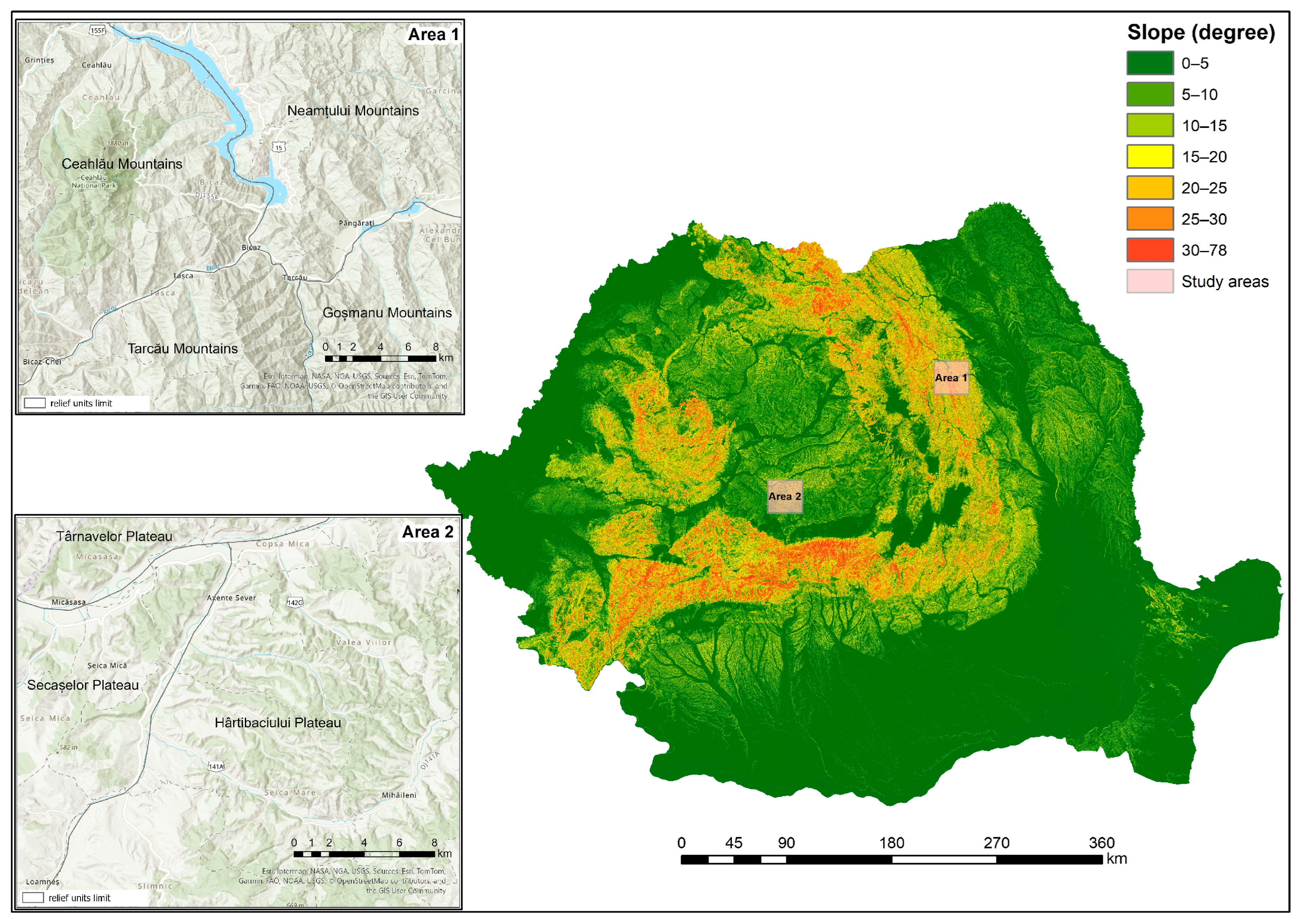
The study of succolarity was conducted in the two test areas (
Figure 1): the mountainous Ceahlău area (1) and the hilly Blaj–Vulpăr area (2). These areas were chosen for their complex relief, both in terms of genesis and geomorphological characteristics. Area 1 (Ceahlău) is a massive mountainous region with low fragmentation and limited accessibility to the valleys that cross this geographical area. Zone 2 is a hilly geographical area with altitudes exceeding 45 m. This area is characterized by long, dome-shaped, fragmented, and eroded hills, as well as a hydrographic network. It shares similarities with military training ranges where military vehicles are tested.
The Ceahlău Mountains exemplify a rugged mountainous terrain characterized by steep slopes and complex topographic variations, making them an ideal site for evaluating succolarity in challenging geographical environments. In contrast, the Blaj–Vulpăr Hills offer a fragmented yet accessible landscape, closely resembling conditions found in military test zones. This dual selection of case studies provides contrasting terrain types, including mountainous and hilly, which enables a more comprehensive validation of succolarity as a metric for terrain accessibility. Such diversity increases the generalizability of the study across different geographical contexts and land-use scenarios.
The slope map was created using the open-source QGIS platform and the Digital Terrain Model (DEM). Digital elevation data were obtained from SRTM v3 at 30 m spatial resolution (acquisition ≈ 2000; typical vertical RMSE ≈ 10 m). Tree cover was from Global Forest Change–Treecover2000 at 30 m. All rasters were co-registered and resampled to 30 m before processing. The 30 m grid captures meso-scale morphology but not meter-scale micro-relief, which is reflected in the interpretation of succolarity indices (see
Section 4, Discussion). The SRTM product is a radar-derived surface model (DSM-type) affected by the canopy in forests. While tree cover can locally bias slopes, our workflow explicitly encodes compact forests as obstacles and evaluates directional accessibility on binary masks, preserving relative accessibility patterns despite DSM effects.
The slope map was created using the open-source QGIS platform and the Digital Terrain Model (DEM). The analysis was conducted on slopes ranging from below 5° to 25–30°. Slopes above 30° were excluded from the analysis due to their inaccessibility to any type of vehicle. The intervals were selected based on the slopes’ accessibility for vehicles, as described by Förster and Paulus [
37]:
- (a)
Slopes below 15° are accessible for cars and tanks;
- (b)
Slopes below 30° are accessible for tracked vehicles;
- (c)
Slopes above 30° are inaccessible for vehicles.
In the selected territorial sections for analysis, the degree of forest cover was also considered using the open Global Forest Change platform [
38]. From this platform, the Tree Cover 2000 dataset was downloaded for the chosen samples, and the corresponding forest layer was overlaid on the slope map. Compact forest denotes areas of high canopy density derived from the Global Forest Change (GFC) dataset. Pixels with tree cover ≥ 60% and belonging to patches of at least 1 ha (8-neighbor connectivity) were classified as compact forest. These patches were treated as obstacles (white) in the binary images because dense forest structures significantly restrict accessibility on undeveloped slopes. By integrating both slope and forest information, the analysis moves beyond a purely topographic approach, capturing the combined impact of terrain and vegetation as dual constraints on accessibility.
In this study, accessibility is defined as directional percolation-based traversability measured via succolarity on binary images (black = percolable, white = obstacles). Undeveloped land denotes terrain lacking engineered surface improvements; movement is primarily constrained by natural morphology and vegetation.
Data summary: DEM—SRTM v3 (30 m; acquisition ≈ 2000; typical vertical RMSE ≈ 10 m); Tree cover—Global Forest Change “Treecover2000” (30 m). All rasters were co-registered and resampled to 30 m before processing. SRTM is a radar-derived surface model (DSM-type) affected by canopy in forests. Because a compact forest is modeled as obstacles and succolarity is directional and relative, canopy effects on slope do not alter the comparative accessibility patterns discussed here.
2.2. Image Pre-Processing for Succolarity Analysis
To apply succolarity, we first pre-processed the slope images obtained in QGIS. The images were converted to 8-bit grayscale using the open-source Fiji/ImageJ 2.9.0/1.53t–Java 1.8.0_322 (64-bit) software [
39,
40,
41]. In these images, the gray value ranging from 0 to 255 corresponded to the slope angle range of 0–90°. Then, one image for each predefined slope interval was extracted through binarization. Although slope thresholds can also be generated in QGIS, we used Fiji/ImageJ to standardize all pre-processing steps. This platform converts the raster data to 8-bit grayscale (0–255), enabling reproducible thresholding and batch binarization for each slope interval. The use of Fiji also ensures direct compatibility with the ComsystanJ plugin used later for succolarity computation, minimizing format conversions and ensuring consistent pixel-level processing. We used six discrete slope bands (0–5°, 5–10°, 10–15°, 15–20°, 20–25°, 25–30°) for binarization and colocalization. Two types of slope ranges were used in this study: (1) functional categories, following Förster & Paulus (1985), describe vehicle accessibility thresholds (below 15°, below 30°, above 30°) and serve only as reference classes; (2) analytical intervals (0–5°, 5–10°, 10–15°, 15–20°, 20–25°, 25–30°) were employed for image binarization and colocalization. In figures summarizing results, additional cumulative ranges (e.g., 0–10°, 0–15°, 0–20°, 0–25°, 0–30°) were used to illustrate progressive changes in succolarity; these are explicitly indicated as cumulative to distinguish them from the discrete analytical intervals used in image processing. Simultaneously, grayscale images of the forest areas were converted to 8-bit and then binarized (using Fiji/ImageJ 2.9.0) [
39,
40], resulting in two binary images, one for each study area. For each area, we produced a single forest mask (white = compact forest; black = non-forest). We then combined this mask with each slope-band binary via logical operations to build the four accessibility scenarios.
To emphasize the limitations on slope accessibility caused by compact forest areas, colocalization was applied to overlay binary slope and forest images. Colocalization is a tool that superimposes spatial distributions between two or more variables and is therefore particularly useful for revealing combined constraints in landscape accessibility [
42]. The colocalization models were generated using the Colocalization Finder plugin for Fiji/ImageJ 2.9.0. This step enabled the creation of binary maps that integrate both topographic and vegetation-related barriers. Slope connectivity indicates slope accessibility, with higher connectivity reflecting greater accessibility.
Following the ImageJ Colocalization guidelines, we binarized both inputs with obstacles in white: (i) the restrictive slope mask (white = slope above the reference threshold, black = within reference) and (ii) the forest mask (white = compact forest, black = non-forest). Colocalization was then performed on white-on-white binary images so that spatially coincident obstacles appear in white in the output. Scenario maps were obtained via logical combinations of the two obstacle layers (e.g., AND for joint obstacles, NOT for the absence of an obstacle). Prior to succolarity computation, binary images were harmonized to the succolarity convention (black = percolable, white = obstacle) by inverting layers where needed so that only percolable (black) pixels could be flooded from the selected border. The colocalization process produced composite color maps where overlapping and non-overlapping regions are displayed in distinct colors, following the ImageJ Colocalization standard. In the output images, red pixels correspond to the restrictive slope mask, green pixels to the forest mask, and yellow pixels indicate their spatial overlap (both restrictive slope and compact forest). Areas without obstacles appear in black. This visualization facilitates the interpretation of spatial constraints by highlighting regions where multiple limiting factors coincide.
Implementation notes:
Fiji/ImageJ steps: Image > Type > 8-bit → threshold each layer → Process > Binary > Make Binary (ensure white foreground = obstacle) → Process > Image Calculator… (e.g., AND) to obtain colocalized obstacle(s) → invert as needed so that black = percolable for succolarity.
Logical definitions of scenarios (symbolic):
Low overall accessibility = (restrictive slope white) AND (forest white)
Limited forest accessibility = (restrictive slope black) AND (forest white)
High overall accessibility = (restrictive slope black) AND (forest black)
QGIS equivalent: Raster Calculator with 0/1 rasters (1 = obstacle/white, 0 = percolable/black):
low_overall = (slope_restrict == 1) * (forest == 1)
limited_slope = (slope_restrict == 1) * (forest == 0)
limited_forest = (slope_restrict == 0) * (forest == 1)
high_overall = (slope_restrict == 0) * (forest == 0)
If needed for succolarity, invert to 0 = percolable (black), 1 = obstacle (white).
After verifying the spatial overlap visually, the resulting RGB composites were converted back to binary (white = obstacle, black = percolable) for subsequent succolarity computation, ensuring full compatibility with the flooding model.
Because succolarity requires black = percolable and white = obstacles, all colocalized outputs used for σ_dir were verified or inverted to this convention before flooding (four directions).
For each study area, six images were obtained. Colocalizations were made between each slope interval map and the forest distribution map, resulting in four scenarios:
Low general accessibility: slopes above the reference level combined with compact forest;
Limited slope accessibility: slopes above the reference level but without forest;
Limited forest accessibility: slopes within the reference level but with compact forest;
High overall accessibility: slopes within the reference level and without forest.
The reference levels considered were slopes of 0–5°, 5–10°, 10–15°, 15–20°, 20–25°, and 0–30°. By structuring the analysis in this way, we ensured that the subsequent succolarity evaluation reflects the joint effects of slope and vegetation, rather than treating them in isolation.
2.3. Succolarity, Succolarity Reservoir and Delta (Δ) Succolarity
The assessment of accessibility in the analyzed areas, using the succolarity algorithm, was based on the virtual water’s ability to percolate through the test area in a predetermined direction. Succolarity is a measure of terrain accessibility based on the percolation of “virtual water” through a binary representation of the landscape. It quantifies the ease with which one can move through different topographic configurations, providing information on land accessibility and connectivity.
Each pixel position is classified as either empty (black pixels) or filled with an impenetrable mass (white pixels). Melo and Conci [
43,
44] describe the computational principle of succolarity in detail, adopting a box-counting approach for 2D images. In accordance with this principle, the procedure begins with binarization of the slope–forest images, where black pixels represent percolable areas and white pixels represent obstacles. The virtual fluid pressure values applied to the images depend on the number of image pixels and the scale size of the measurement box (box-counting) for each direction. Fluid flow is simulated through all connected pore pixels (black pixels) in each direction, while fluids cannot flow through the obstacle pixels (white pixels).
The next step is flooding. For each direction (left-to-right, right-to-left, top-to-bottom, bottom-to-top), flood-fill operations start from the corresponding image border. Only connected black pixels are considered flooded, ensuring that percolation is measured exclusively through accessible paths.
The target fluid flow area is then divided into equally sized boxes in the images and denoted as “BS(k)”, where k represents the number of possible box partitions of an image. The occupancy percentage for each image box size is then directly measured on the images and noted as “
OP(
BS(
k))”. For each box size k, the pressure value is calculated using Equation (1) [
43]:
where “n” represents the number of possible divisions, and “PR(BS(k), pc)” represents the pressure on the centroid of box “k” on the scale of consideration.
In order to make the succolarity value dimensionless, the value of the pressure occupancy is divided by the value of the pressure (Equation (2)):
The term “dir” represents the direction, such as left-to-right, right-to-left, top-to-bottom, or bottom-to-top.
When analyzing images with slope–forest colocalization, succolarity was examined in four directions—top-to-bottom, bottom-to-top, left-to-right, and right-to-left—to distinguish the degree of accessibility from different predefined directions. Values close to 1 indicate maximum accessibility in that direction, while values close to 0 indicate inaccessibility.
We couple succolarity with tree cover masks because compact forest patches behave as coherent barriers that reduce directional permeability even where slope alone would allow movement. This integration converts purely geometric slope assessments into functional accessibility estimates reflecting both morphology and vegetation.
Succolarity reservoir (
σres) is a recent index [
2] and is intended to indicate the extent to which the degree of percolation could be extended if obstacles isolating part of the patches could be penetrated.
Succolarity reservoir is calculated using Equation (3):
Unlike succolarity, which is direction-dependent, the succolarity reservoir provides a global overview of the terrain’s potential accesibility.
Delta succolarity (Δ
σ_dir) is then defined as the difference between the reservoir succolarity and the directional succolarity (Equation (4)):
This metric highlights the gap between actual and potential accessibility.
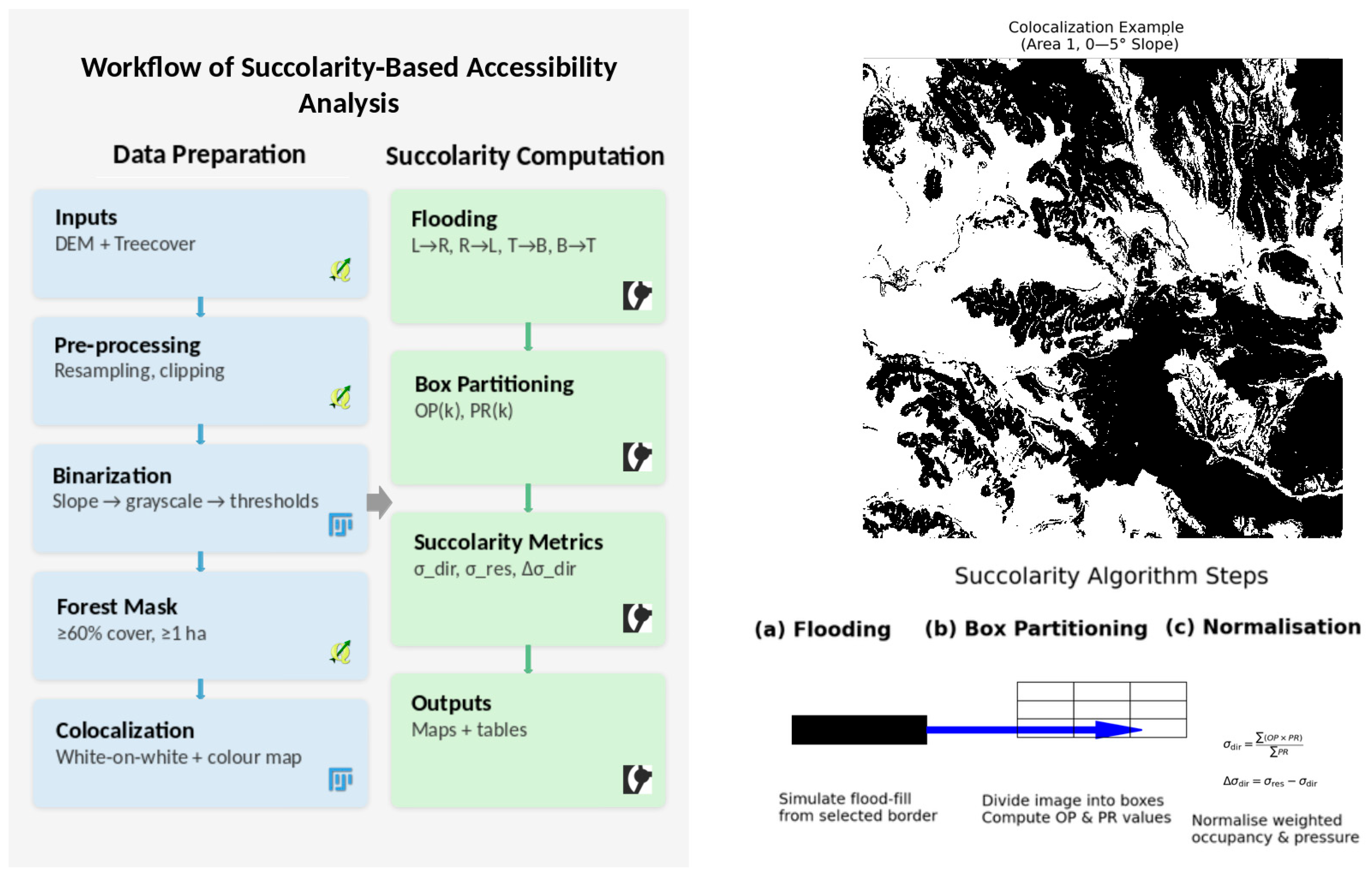
A flowchart summarizing these methodological steps is provided in
Figure 2, ensuring clarity and reproducibility. The workflow follows the exact sequence represented in
Figure 2, which illustrates (a) directional flooding of percolable pixels from a chosen border, (b) box partitioning and computation of occupancy and pressure values, and (c) normalization steps used to obtain the final succolarity values. This graphical supplement clarifies the key algorithmic stages and supports the reproducibility of the analysis.
Implementation: Language-independent code for computing succolarity can be written for each direction. The input is a binary image where the background (floodable area) is coded as black and obstacles as white. A flooding image of equal size is initialized with zero values. Starting from the chosen border, flood-fill iteratively marks all accessible black pixels. Succolarity values are obtained by looping through the flooded image, computing the occupation percentage within boxes of distinct sizes, and weighting by the corresponding pressure (mean distance from the inflow border). After normalization, a vector of succolarity values is obtained. The same procedure is repeated for all four directions (left-to-right, right-to-left, top-to-bottom, and bottom-to-top). All succolarity computations in this study were performed using the open-source Comsys-tanJ plugin for ImageJ/Fiji, developed by Helmut Ahammer and collaborators (
https://github.com/comsystan/comsystanj), accessed on 15 February 2025. The implementation follows the class Csaj2DFracSuccolarity_.java in the at.csa.csaj.plugin2d.frac package, which performs directional flooding, pressure weighting, and normalization for succolarity, succolarity reservoir, and Δ succolarity. This ensures that all results are reproducible and verifiable by the research community.
3. Results
3.1. Colocalization Slope–Forest
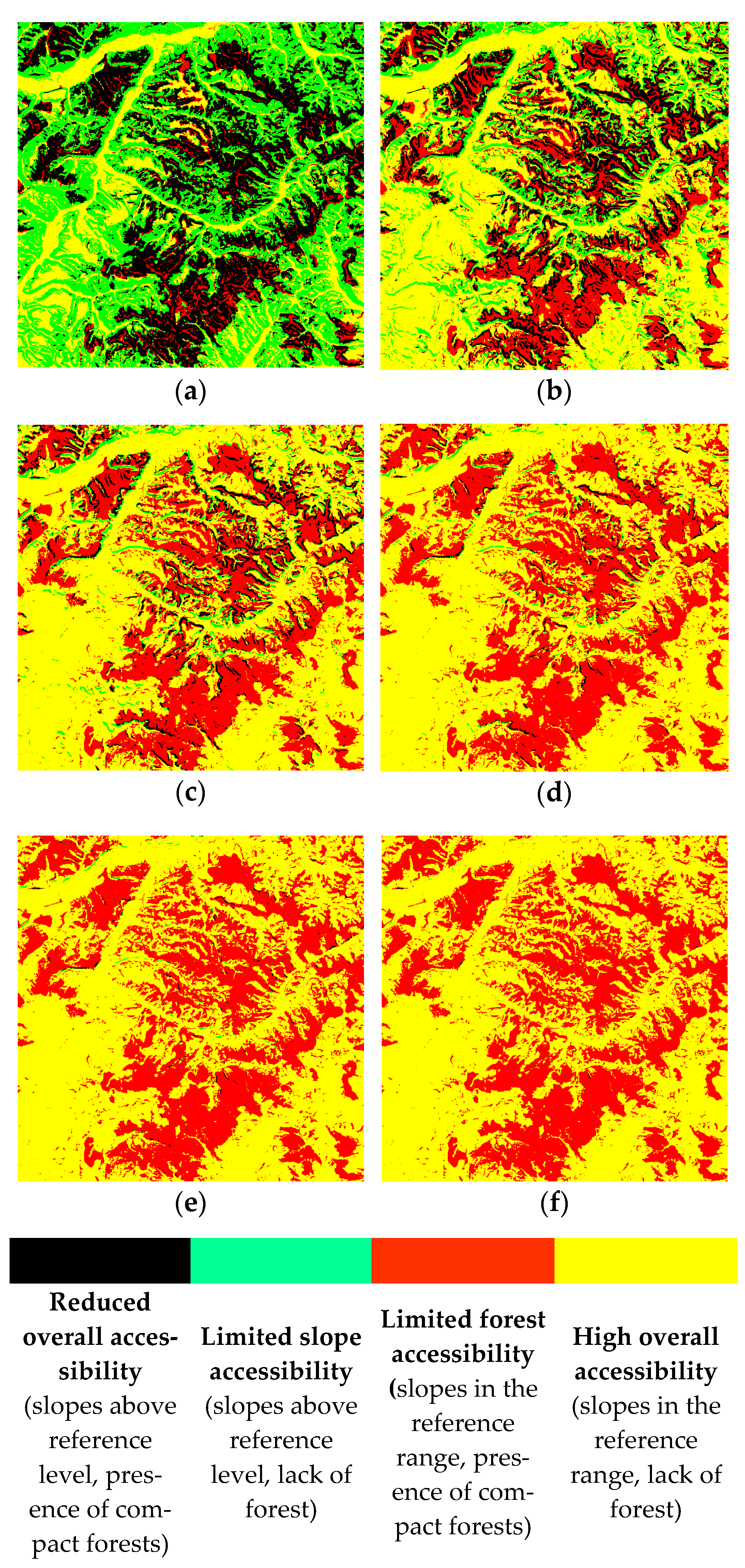
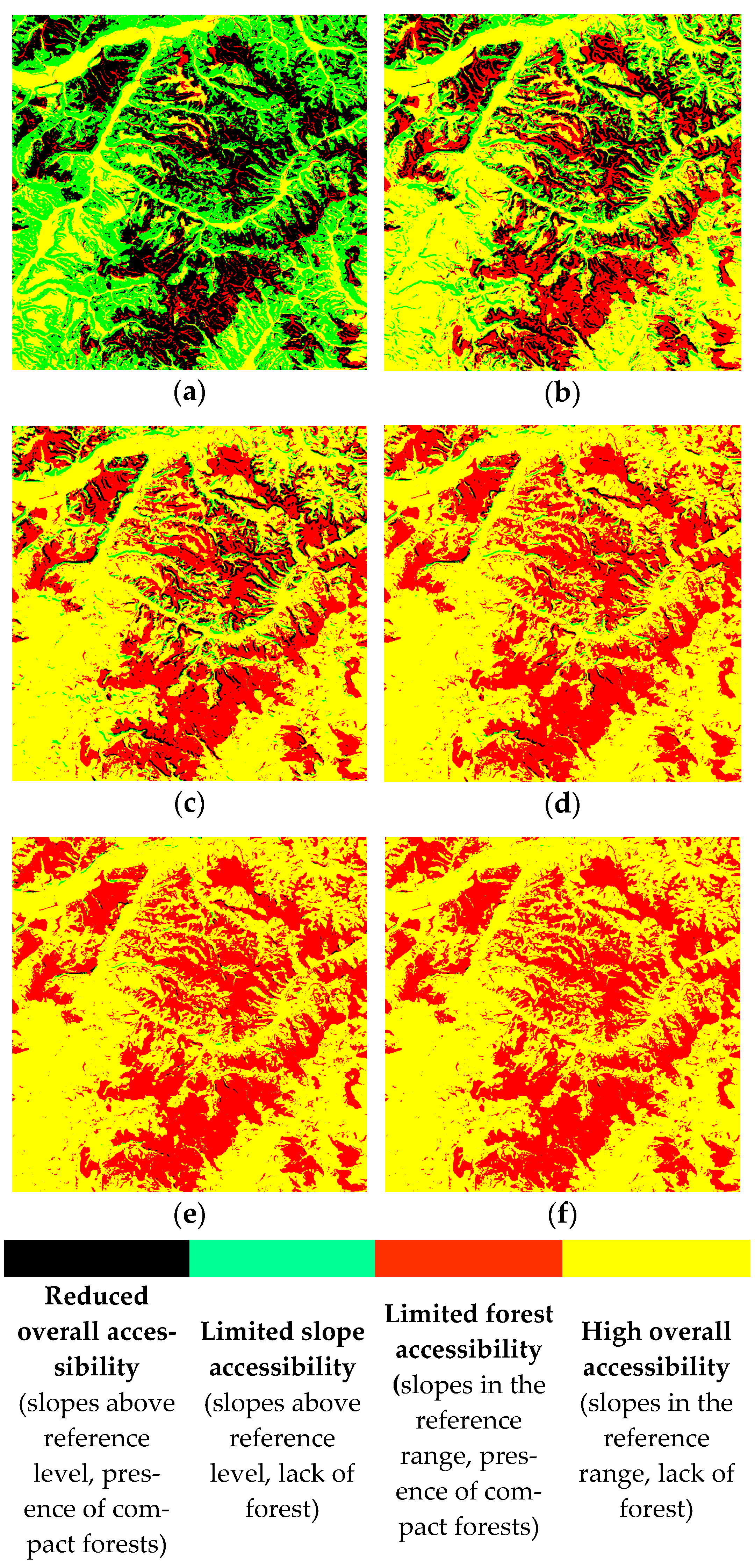
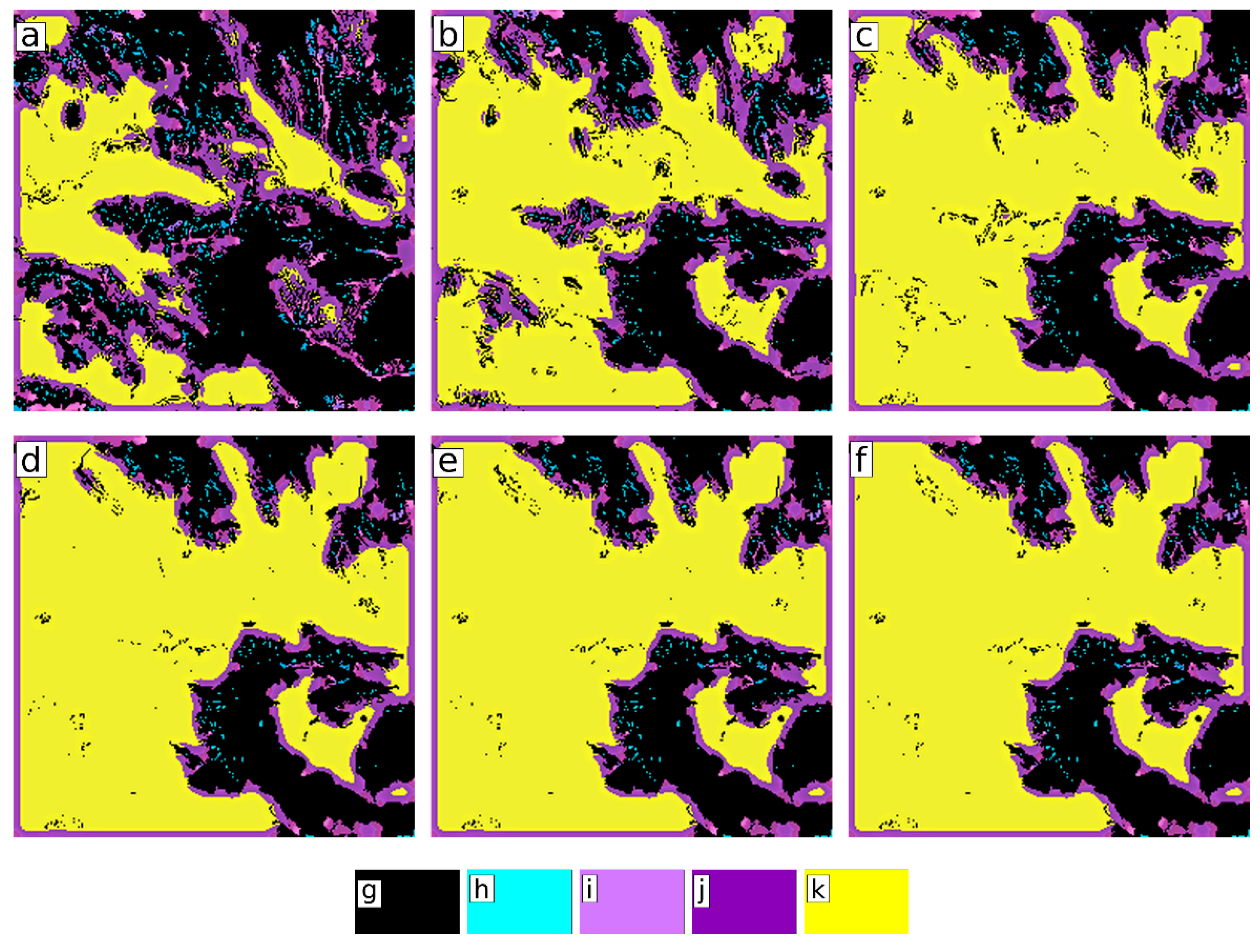
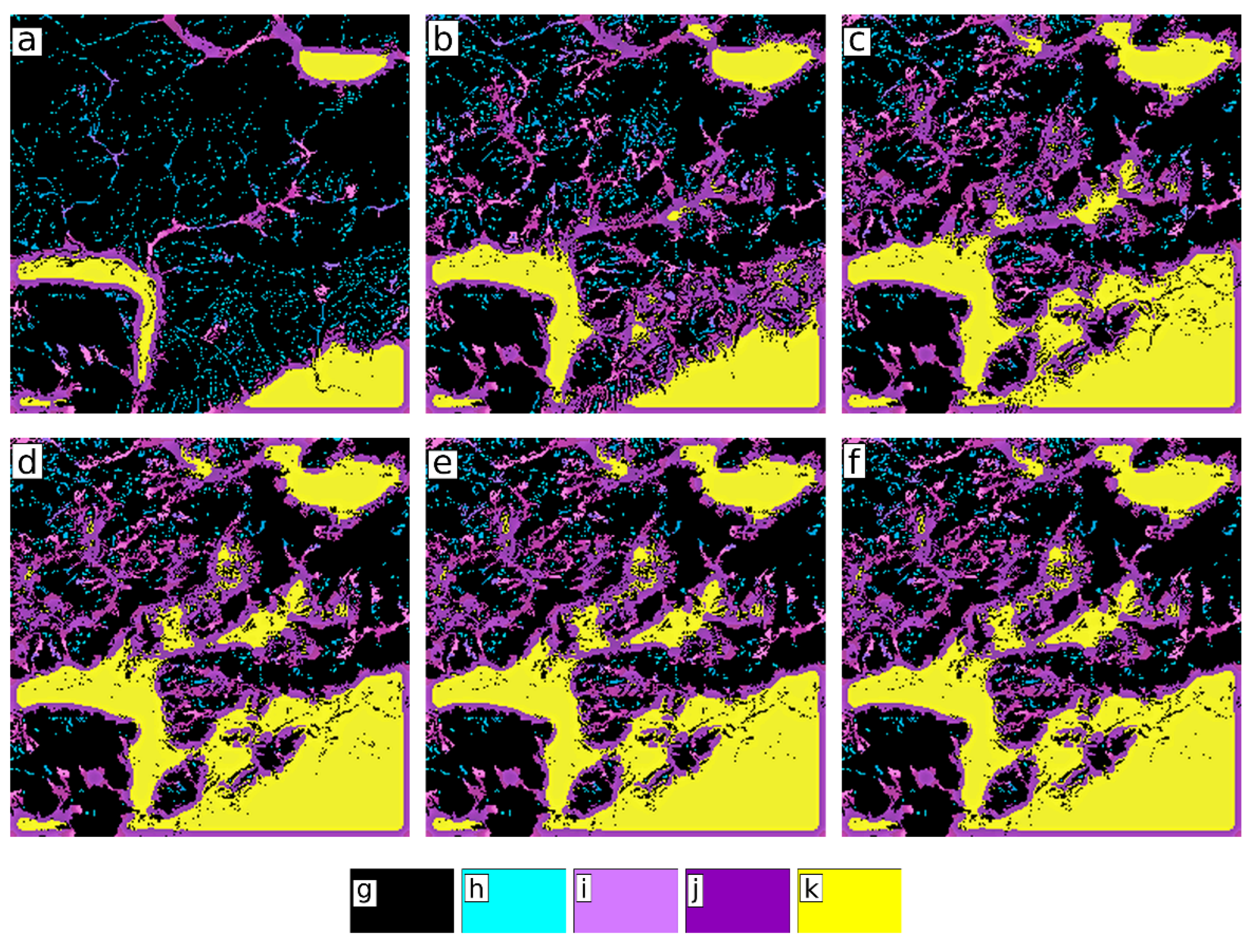
A slope–forest colocalization was carried out, with compact forest areas considered as limiting factors for slope accessibility (
Figure 3 and
Figure 4). The correlation between slope accessibility and the constraints imposed by compact forest areas has led to a general model of accessibility that is useful in establishing design parameters for different types of vehicles that must approach terrain without specific landscaping. In
Figure 3, the slope–forest colocalization in Area 1 (Ceahlău Mountains) highlights the accessibility specific to forested mountain areas, where high accessibility is only found in the valleys that fragment the mountain unit (
Figure 3). The limited accessibility observed in the steep valleys of the Ceahlău Mountains presents challenges for emergency response deployment, infrastructure planning, and forest resource management. The fragmented terrain and dense forest cover create natural barriers that restrict movement, posing significant constraints for land-use planning.
In contrast, the Blaj–Vulpăr Hills, despite their fragmented structure, exhibit higher accessibility potential, making them more suitable for sustainable land management and infrastructure development. This comparative perspective clearly illustrates how succolarity analysis can distinguish between mountainous and hilly terrains, revealing differences that are essential for both theoretical modeling and practical planning.
The high proportion of areas with reduced accessibility (
Figure 3a–c) suggests that additional land-use strategies may be necessary. Measures such as the development of controlled access routes or selective deforestation in key areas could enhance connectivity. These findings are particularly relevant for environmental conservation and strategic land-use planning. Due to the fragmentation of the relief, there are only small differences in slope levels outside the main valleys, where accessibility is reduced. For the slope ranges 0–5° and 0–10°, a very high proportion of areas with reduced accessibility is observed due to the high proportion of slopes above 10° and compact forest areas (
Figure 3a–c), while slopes above 20° have limited accessibility due to the presence of compact forests (
Figure 3d–f).
In both research areas, colocalization was found to be relevant in assessing different degrees of accessibility to geographic spaces of high fragmentation and complexity. Slope accessibility is an important element in the design of land-use types, contributing to the integration of land features into the broader landscape. This dual assessment underscores the methodological strength of succolarity when applied to combined slope–forest scenarios.
Figure 5 and
Figure 6 show the accessibility of the two study areas through the connectivity colocalization between slopes and compact forest areas. The high values indicate that there is a direct correlation between the two parameters (slope and colocalization connectivity), which is also illustrated by the values obtained in the analysis carried out within the two study areas. Where the values are higher (violet and yellow colors—1.00–2.99 LCFD map values), accessibility and connectivity are higher, and vice versa. However, accessibility tends to be significantly reduced when restrictive parameters are added (natural—forest areas, or anthropogenic—water accumulations), often lowering values close to zero. In terms of territorial representativeness, the areas with a high degree of connectivity and accessibility are increasingly restricted when additional parameters are considered. This highlights the usefulness of these extra variables in accessibility analysis, especially for larger regions. Compared to an ideal (fully accessible) topographic surface, where the only constraint is slope, the practical situation is markedly different. There is therefore a significant difference between the two study areas: the mountain area (with a lower degree of accessibility and connectivity) and the hill area (with a higher degree of accessibility and connectivity), as shown in
Figure 5 and
Figure 6.
3.2. Succolarity Results
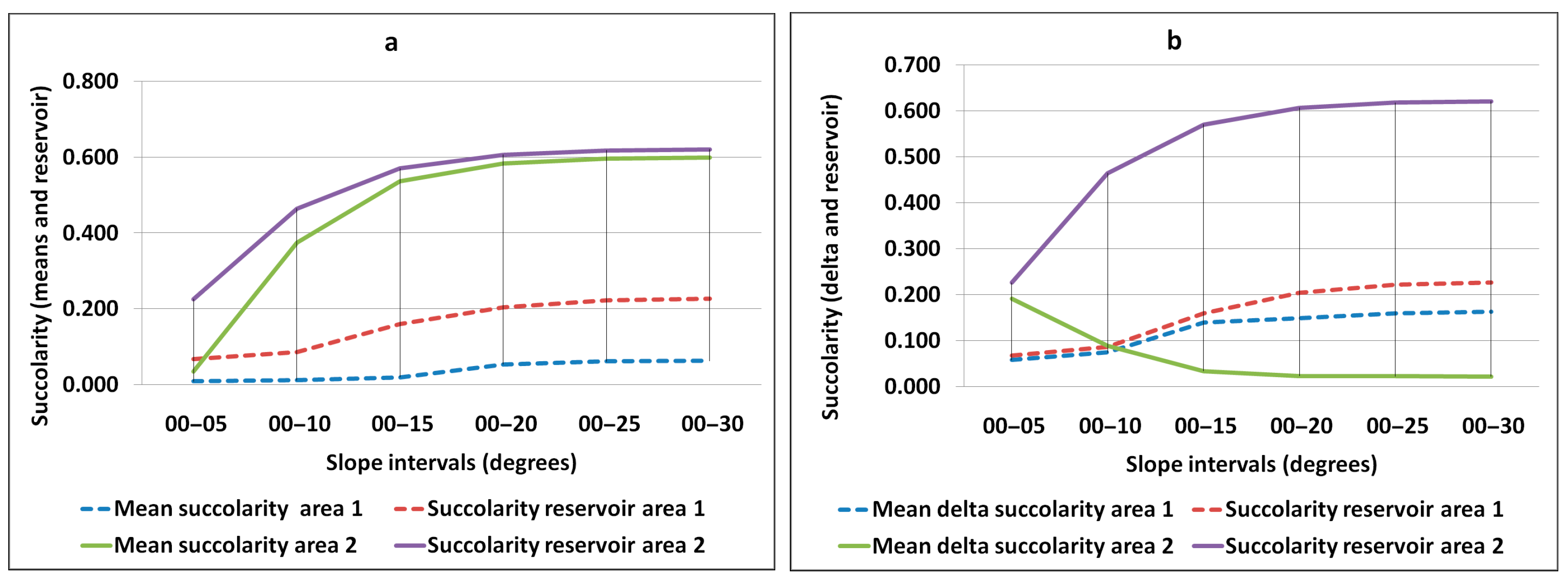
The results reveal a significant contrast between the two study areas. The Ceahlău Mountains exhibit low mean succolarity values (0.01 to 0.06), indicating restricted terrain accessibility due to steep slopes and dense forest cover. In contrast, the Blaj–Vulpăr Hills demonstrate a higher succolarity reservoir (0.035 to 0.598), reflecting improved mobility in less rugged landscapes. However, in the hilly areas, compact forests remain the primary constraint on accessibility, rather than slope inclination. This highlights the importance of integrating both topographic and vegetation-related factors in accessibility assessments.
From a land management perspective, these succolarity variations suggest that infrastructure expansion in mountainous regions should focus on valley corridors to maximize accessibility. In hilly areas, sustainable forest management could enhance mobility by strategically maintaining or modifying vegetation patterns. Such results emphasize that succolarity does not merely quantify physical slope conditions but also reflects how vegetation acts as a decisive barrier in terrain usability.
Figure 7 illustrates the accessibility analysis using mean succolarity, succolarity reservoir (
Figure 7a) and mean Δ succolarity (
Figure 7b), highlighting the significant differences in accessibility of the two geographical areas analyzed: the mountainous area of the Ceahlău Mountains and the hilly area of Blaj–Vulpăr Hills.
Figure 7a indicates that the average succolarity had low values that increase with the slope ranges analyzed: from 0.01 for slopes of 0–5° to 0.06 for slopes of 0–30°. These low values reflect a low degree of accessibility, confirming that the area is predominantly dominated by slopes with an angle of more than 30° and by compact forests. Succolarity reservoir reflects and dominates low accessibility, showing very low values for slopes of 0–5° (0.07) and 0–30° (0.226). Under these conditions, the mean Δ succolarity is below 0.1 for slopes of 0–5° and 0–10° and between 0.1 and 0.16 for slopes of 0–15° and 0–30° (
Figure 7b).
For the area of the Ceahlău Mountains, there are noticeable directional differences, with the best accessibility recorded in the left-to-right (W–E) direction, followed by right-to-left (E–W), while the lowest succolarity was found in the bottom-to-top (S–N) and top-to-bottom (N–S) directions. In contrast, for the Blaj–Vulpăr Hills, the mean succolarity increased significantly, from 0.035 for slopes of 0–5° to 0.598 for slopes of 0–30° (
Figure 7a), indicating a good degree of accessibility in undeveloped areas. Here, the main constraint was the presence of compact forests, rather than slope inclination. This suggests that even in less rugged areas, vegetation structure may become the dominant limiting factor.
Figure 7b shows the succolarity reservoir for the Blaj–Vulpăr Hills, which had much higher values, ranging between 0.23 and 0.62, indicating a better accessibility compared to the Ceahlău Mountains. The situation was different between the two areas in terms of Δ succolarity. In the Ceahlău Mountains, the mean Δ succolarity increased from 0.058 to 0.163 for slopes ranging from 0–5° to 0–30°, while in the Blaj–Vulpăr Hills it decreased from 0.19 to 0.02 for the same slope ranges. This divergence reflects two contrasting accessibility regimes: in mountains, Δ succolarity grows as slope increases (because succolarity reservoir remains high compared to actual succolarity), whereas in hills, Δ succolarity decreases as real succolarity approaches the reservoir potential.
Thus, we could identify two different patterns of succolarity and Δ succolarity, with a clear association to the degree of accessibility (
Figure 7a,b).
The differences between upland and hilly areas can significantly influence how these areas are managed and developed. Suitability analysis remains an important method for assessing the accessibility of undeveloped land, offering insight into how it can be traversed and accessed under different geographical and topographical conditions. The results presented here show significant differences between the two geographical areas studied, reflecting the diversity and specificity of the terrains analyzed. In mountainous areas, suitability values were low in all directions, indicating that accessibility is often limited by steep, fragmented relief, deep valleys, rocky ridges, and compact forests. This fragmentation creates natural barriers to human access, restricts infrastructure options, and constrains potential routes, confirming that mountainous terrain requires different management strategies compared to hilly regions.
The current analysis indicates that Ceahlău exhibits low succolarity across slope ranges due to steep, fragmented relief plus compact forests, whereas Blaj–Vulpăr reaches substantially higher σ_dir where the slope is gentle. In this area, compact forests, not slope, represent the primary limiting factor.
4. Discussion
The results of this study indicate that accessibility in mountainous and hilly regions is influenced not only by topographic factors such as slope inclination but also by the spatial distribution of compact forests. These findings suggest that integrating succolarity analysis into accessibility studies provides a more nuanced understanding of terrain permeability, especially in cases where traditional topographic models fail to capture micro-scale connectivity patterns.
Unlike previous studies that focused on forest connectivity [
2], this research applies succolarity as a measure of accessibility rather than ecological continuity. This conceptual shift allows succolarity to be used as a proxy for terrain mobility, directly linking topography and vegetation to practical constraints on movement. It therefore offers practical insights for terrain management in contexts where forests are obstacles rather than corridors.
The methodology developed in this study can be applied beyond the studied areas to assess terrain accessibility in various undeveloped and developed landscapes worldwide. The ability to quantify percolation through complex topographies makes succolarity a valuable tool for infrastructure planning, environmental management, and disaster response strategies. For example, in mountainous regions prone to landslides, in arid landscapes with dune barriers, or in wetlands where seasonal flooding alters accessibility, succolarity could provide a reproducible and quantitative metric of terrain usability.
These findings could contribute to broader accessibility models for infrastructure development in challenging terrains worldwide. By integrating succolarity metrics into transportation planning, policymakers can optimize road networks in rural or remote areas, ensuring connectivity with minimal environmental disruption. The broader implication is that succolarity-based indices bridge the gap between abstract spatial analysis and applied decision-making in infrastructure planning.
The accessibility of undeveloped land is crucial for protected area management and the optimization of natural resource use. A detailed analysis of terrain accessibility can provide significant economic and environmental benefits, enhance current approaches, and enable more sustainable land-use strategies [
45]. Unlike previous research that used succolarity to assess forest connectivity in the Romanian Carpathians [
2,
46], this study focuses on accessibility in undeveloped geographical spaces, where forests are perceived as obstacles rather than connectivity elements.
In contrast, the hilly areas showed high accessibility in all directions of analysis due to less steep and fragmented terrain, which generally makes crossing easier. However, accessibility in hilly areas can still be influenced by compact forest areas, which can limit access and restrict travel options, especially on high ridges and steeper slopes. We found that topography, such as slope and terrain fragmentation, can create natural barriers to human access, limiting infrastructure and travel options. We also found that vegetation, particularly compact areas of forest, can play a significant role in restricting access and can influence how land is used. Thus, the accessibility of undeveloped land emerges as a multifactorial phenomenon shaped by the interplay between geomorphology and vegetation [
45]. Understanding this relationship is essential for the development of appropriate natural resource management strategies and policies [
47].
The results of the succolarity analysis provide crucial insights into how undeveloped land can be traversed and accessed. This strengthens the argument that succolarity should not remain a purely theoretical construct but be applied in the design of public infrastructure and services. In light of these results, it is important to assess how this information can be applied to ensure optimal and sustainable accessibility [
48]. One of the main uses is in the planning of road networks and other transport facilities [
49]. Identifying areas of low or high accessibility allows us to strategically place road infrastructure, ensuring effective connectivity between different areas and facilitating access to these lands for various economic and social activities [
50].
The results of succolarity analysis can also influence the design of other public services, such as utility networks and emergency services [
47]. Identifying areas of low accessibility allows resources and efforts to be concentrated where they are most needed, ensuring that communities in these areas benefit from the same services and amenities as more accessible regions. Slope–forest colocalization indicates that areas with slopes greater than 10° and compact forest areas limit access, which can influence the design and development of infrastructure and specialized vehicles for rough terrain.
The results of the proposed analysis can also contribute to optimizing existing approaches so that connectivity measures increase the efficiency of forest resource harvesting [
51], as well as research on soil protection by reducing erosion during felling and timber transport [
52]. In forestry and resource extraction, succolarity-based assessments therefore open new opportunities for balancing productivity with environmental sustainability.
Fractal analysis, together with design parameters, can be integrated into the development of the dynamic characteristics of autonomous vehicles designed to negotiate steep terrain for firefighting or military purposes. In this respect, there are many studies with relevant results [
53,
54,
55,
56,
57]. The proposed methodology can also support analyses of the complex relationship between morphological characteristics, road density, and land use [
13], ultimately contributing to the optimal configuration of road networks with minimal disturbance of natural morphology.
The results obtained can contribute to the development of future research projects, including the possibility of expanding forest areas on land that is not suitable for other economic activities due to its accessibility [
58]. The measurement of slope accessibility is also an important element in land market studies, and many of the studies conducted to date have methodologies that do not include land morphology variables [
59]. Thus, the connectivity of slopes with certain gradients, their fragmentation, as well as the presence or absence of forested areas, can bring more objectivity to the assessment of the market value of land. Accessibility is one of the main causes of poverty in rural areas, so multi-parametric methods of slope accessibility analysis provide data on terrain morphology, allowing for the development of road infrastructure that can be built at minimal cost [
60,
61].
The data obtained through the fractal analysis of slope accessibility can be integrated into modeling soil susceptibility to erosion [
62] and thus be useful for planning management measures [
63]. The developed methodology also extends previous applications of fragmentation fractals, showing that succolarity-based indices are sensitive to land morphology, vegetation, and anthropogenic interventions. Because slope and succolarity are resolution-dependent, results at 30 m primarily reflect meso-scale morphology (valley floors, interfluves) rather than micro-relief (ruts, rocks, downed logs). Consequently, the absolute values of σ_dir could change with finer DEMs (e.g., ≤10 m), although our comparisons between areas remain valid due to identical resolution and processing. A future sensitivity analysis across multiple DEM scales would quantify how σ_dir and Δσ_dir respond to resolution changes.
Several limitations should be acknowledged when interpreting the present results. First, the resolution of the SRTM DEM (30 m) constrains the detection of micro-relief features such as ruts or small boulders, meaning that succolarity indices reflect meso-scale rather than fine-scale terrain accessibility. Second, the classification of compact forest areas from the GFC Treecover2000 dataset is subject to potential uncertainty due to the 60% threshold and minimum patch-size criteria, which may locally over- or underrepresent forest obstacles. Third, succolarity metrics are sensitive to the slope-threshold definitions and binarization parameters used; small changes in these settings can influence the magnitude of σ_dir and Δσ_dir, although the overall spatial patterns remain robust. Fourth, the study did not include direct field validation or GPS-based ground truthing, which will be addressed in subsequent work through in situ measurements and high-resolution remote-sensing verification. In addition, soil type imposes different constraints on slope accessibility under dry versus wet conditions, and the hydrographic network significantly alters the connectivity of areas with similar slope values. Future research will therefore incorporate soil, hydrological, and seasonal vegetation data as additional constraints to refine accessibility modeling. Despite these limitations, the reproducibility of the workflow and the consistent patterns observed in both study areas support the robustness and transferability of the proposed succolarity-based approach.
Assessing the accessibility of undeveloped land has important implications for sustainable development and natural resource management [
47]. In terms of sustainable development, accessibility plays a crucial role in the planning and design of infrastructure and public services in hard-to-reach areas. By assessing and identifying areas of low and high accessibility, decision-makers can make informed choices about infrastructure placement, supporting socio-economic growth while minimizing environmental costs [
64]. This study highlights differences in accessibility between mountainous and hilly areas, emphasizing the influence of topography and vegetation. The accessibility of undeveloped land is crucial for efficient and sustainable management and has significant implications for infrastructure planning. The findings can inform decision-making regarding infrastructure placement in remote areas, contributing to the socio-economic and sustainable development of these regions.
In conclusion, the proposed methodology demonstrates that succolarity, together with reservoir and delta indices, offers a robust, reproducible, and transferable approach to terrain accessibility analysis. By integrating additional datasets and refining methods in future research, this framework can evolve into a comprehensive tool for sustainable land management, planning, and strategic operations.
5. Conclusions
Succolarity analysis provided valuable insights into the accessibility of undeveloped land, revealing how terrain can be traversed and accessed under different topographic and vegetation conditions. By integrating slope and forest constraints into a single framework, the methodology captures both geomorphological and ecological barriers, offering a more complete perspective than traditional models.
By identifying and mapping areas of low and high accessibility, decision-makers can make informed choices about the placement of roads, access routes, and other essential infrastructure to support sustainable development and efficient land use. This ensures that infrastructure expansion can be achieved with minimal environmental impact while maximizing socio-economic benefits.
The study demonstrates that succolarity, together with its extensions (succolarity reservoir and Δ succolarity), is not only a theoretical fractal index but also a practical tool for land-use planning, infrastructure design, and strategic operations in complex terrains. Applying these findings to infrastructure design can enhance connectivity, leading to more accessible and integrated communities, with significant contributions to sustainable development.
The present framework provides a reproducible foundation for future developments in terrain accessibility modeling. Subsequent research will address the limitations identified above by performing multi-resolution sensitivity analyses of DEM scale effects, refining forest-classification thresholds, and integrating additional topographic variables such as curvature and surface roughness. Further work will also incorporate existing road networks and field-based validation to compare succolarity-derived accessibility maps with empirical mobility data. These steps will strengthen the applicability of succolarity as a quantitative and transferable tool for sustainable land management, risk assessment, and planning in undeveloped regions.
