Abstract
Population growth, urbanization, improved infrastructure, and climate change are reshaping land use systems worldwide, creating spatial trade-offs between economic development, ecosystem services, and cultural heritage. In Ladakh, Himalayan India, mass tourism and recent political changes have triggered a particularly rapid transition from traditional subsistence farming to market-oriented production, raising concerns about the sustainability of changing land management practices, cultural identity, and growing dependence on external inputs. To disentangle these concerns, we investigated land use changes, development patterns, and socio-economic drivers over the past 40 years. To this end we merged Landsat-based remote sensing data with household surveys in two contrasting, urbanizing regions—the Union Territory’s capital Leh and its more remote, third largest town of Diskit. Spatially explicit land cover maps for three periods of the 1970s, the 2000s, and the 2020s revealed an eightfold increase in residential area in Leh, with 41.7% of agricultural land converted to urban use, compared to a twofold increase and only 1.7% farmland loss in Diskit. Expansion of urban land use in Leh occurred in all directions across multiple land use types, while in Diskit, it remained localized to previously unused land. Survey data on socio-economic parameters showed a production shift toward goods demanded by tourism and the military, the latter being linked to border tensions with China and Pakistan. The divergent dynamics highlight the need for integrated spatial planning and scenario analysis to balance globalization-driven development with the conservation of cultural landscapes and ecosystem services. We recommend ecotourism-based strategies as an optimized pathway toward sustainable and multifunctional land systems in mountain regions.
1. Introduction
Global urbanization is driving major changes in rural land cover and land use, not only in and around rapidly growing cities but also in rural settlements and their vast hinterlands, regardless of how remote and disconnected from large cities they may be [1]. In Ladakh, improved infrastructure and rapidly expanding tourism [2] have emerged as both drivers and consequences of these changes, amplifying telecoupling effects of unrestrained urban demands for food and non-food commodities [3]. Since 31 October 2019, when the Government of India reconstituted Ladakh—previously part of Jammu and Kashmir—into a Union Territory, processes of urbanization and globalization have rapidly accelerated [4].
Rural–urban land use transitions have become a central focus in studies of global change, as they reflect the interplay between economic development, demographic shifts, and cultural transformation. In particular, tourism development is increasingly recognized as a key driver of such transitions in mountain regions, where traditional agro-pastoral systems encounter growing demands for infrastructure, services, and markets [2]. These processes reshape not only land cover but also local livelihoods, cultural landscapes, and the sustainability of ecosystem services. By examining Ladakh through this lens, our study situates a local case within broader debates on how globalization and tourism accelerate land use change in rural highland environments.
Mountain regions such as the Himalayas, long characterized by their difficult access and remoteness, have historically supported agricultural systems that were predominantly subsistence-oriented [5,6]. In Ladakh, agro-pastoralism has been practiced for millennia under climatically harsh, hyper-arid, desertous high-altitude conditions ranging from 2300 to 7672 m above sea level, with an annual mean temperature of 5.2 °C and only 103 mm of precipitation [7,8,9]. This region exemplifies how sudden exposure to global markets and cultures can trigger profound lifestyle changes that merge rural traditions with urban influence [3]. Until recently, rugged terrain and heavy winter snowfall restricts access to Ladakh for nearly half the year [10,11]. Furthermore, the Indo-Pakistani and Indo-Sino border conflicts [12,13] in Kashmir (1947), respectively, led to prolonged travel bans for national and international visitors, reinforcing the region’s isolation. The lifting of these restrictions in the 1970s, alongside permanent road construction [14,15] (Figure 1), entailed an influx of visitors whose economic, social and cultural practices differed markedly from Ladakh’s deeply rooted Buddhist traditions. Additional drivers of change included the establishment of border security camps, the introduction of development programs by governmental and non-governmental organizations, and greater international networking [16].
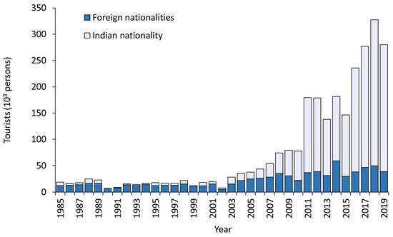
Figure 1.
Development of tourism in the region of Ladakh during the past decades, from 1985 to 2019. Source: [15].
Consequently, Ladakh’s agriculture has undergone rapid transformation, affecting both livelihood strategies and land use, with implications for soil, water, and biodiversity [17,18]. While recent research has explored the impacts of modernization—particularly mass tourism—on the urban structures of Ladakh’s capital, Leh [3,15,19,20,21,22], only few studies have examined the consequences of rural–urban transformation and tourism-driven modernization for agro-pastoral systems in Ladakh’s rural hinterlands [23].
To detect land use change transformation processes, remote sensing approaches have since long provided indispensable tools for monitoring land use and land cover change in mountainous regions, enabling repeated observation across rugged terrain where conventional field surveys are difficult. Advances in methods—such as machine learning, object-based image analysis, and data fusion—have improved classification accuracy at regional scales. In recent years, unmanned aerial vehicles (UAVs or drones) combined with deep learning have enabled very high spatial resolution mapping (centimetre to decimetre scale), which is especially promising for capturing fine-grained changes in land cover and structural details. However, small and remote mountain areas often remain underrepresented: high-resolution satellite or UAV imagery is often unavailable or prohibitively expensive, and harsh topography, micro-climate variation, and limited ground control make image acquisition and classification very challenging [1]. As a result, fine-scale land transitions—such as small patch conversion, changing edges of settlements, or fragmentation of agro-pastoral plots—are often overlooked, creating a “blind spot” in remote sensing studies of mountain landscapes.
Against this background, the present study seeks to fill this gap by applying a mixed-methods approach that combines remote sensing of Landsat imagery over a 40-year period with field surveys in and around Ladakh’s capital, Leh, and the remote secondary town of Diskit. While remote sensing provides spatial information on landscape transitions under recent changes, field surveys offer detailed insights into household conditions and driving factors that cannot be captured through the limited literature and remote sensing data alone. We hereby address the two following research questions:
- How have land cover and land use patterns changed over the past four decades in Ladakh’s capital Leh, a major tourism hub, compared with the more remote secondary town of Diskit?
- In what ways have rural–urban transformation and tourism-driven modernization influenced livelihood strategies and the mix of traditional and new income sources in these two contrasting locations?
By exploring these questions, the study provides insights into how globalization and tourism jointly shape land use trajectories in fragile mountain regions. The findings contribute to broader debates on rural–urban transitions by offering lessons that extend beyond Ladakh to other highland environments worldwide, where economic growth pressures increasingly intersect with cultural heritage and ecological sustainability.
2. Materials and Methods
2.1. Study Area
Tourism in Ladakh holds significant potential due to the region’s unique cultural heritage, high-altitude landscapes, and reputation as a destination for adventure, spirituality, and eco-tourism. Among the two sites of this study, the city of Leh represents a tourism hotspot [3] of 1046 ha, whereas the ancient monastic three times smaller village of Diskit (373 ha) is separated from Leh by the Ladakh Himalayan range and located about 100 km northwards on the banks of the Shyok River (Figure 2). The high-elevation area with its rugged terrain is intersected by several valleys, with the Indus Valley being the lowest point. Leh and Diskit are bounded by the Great Himalayas in the south and the Karakoram in the north. These ridges block the more southern monsoon rainfalls, thus positioning both settlements in a rain shadow. The resulting sparse precipitation, combined with a relative high evapotranspiration and further accentuated by high elevation, determine a cold arid desert climate [5]. The whole region is therefore characterized by harsh climatic conditions and a vulnerable high-altitude environment. Local traditions, partly as adaptions to these conditions, still prevail in both locations and, although Leh and Diskit differ in the intensity of tourism, they share similar traditional practices of crop and animal husbandry.
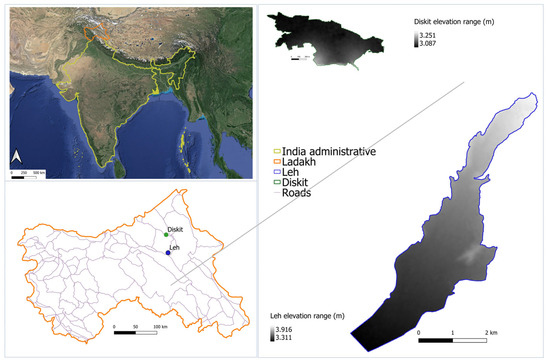
Figure 2.
Map of the research area in the Himalayan Indian Union Territory of Ladakh. Source of satellite image: Google Big Photograph as a tile in QGIS 3.22 assessed on 31 July 2024.
To answer our research questions, we examined decadal changes in land use patterns and land allocation in the tourism hotspot Leh and the smaller, rural and remote Diskit, which due to hosting the oldest and largest Buddhist monastery in the region [24], still receives a certain number of visitors each year. To compensate for the unbalanced spatial design, we combined a household survey to complement the remote sensing data with information on peoples’ agricultural practices and their views on the ongoing transformation processes.
2.2. Land Use Change from the 1970s to 2019
To examine land use changes and their association with agro-pastoral practices and income-generating activities, land use patterns in the settlements of Leh and Diskit were differentiated at three points in time: (1) period between 1972 and 1974: travel restrictions for foreigners to the region; (2) 2002/2003: start of the tourism boom; (3) 2018/2019: rapid increase in the number of Indian visitors [3]. The boundaries of the two locations of interest were defined based on high-resolution true eye colour images of 2018 and 2019 using Google Earth Pro 7.1 (accessed 20 March 2021). In addition, six high-resolution Corona black and white (1972 and 1974) and four true eye colour (RGB Red, Green, Blue) Google Earth images (2002/2003, 2018/2019) with a resolution ranging from 1 to 6 m were downloaded from the United States Geological Survey website (https://earthexplorer.usgs.gov, accessed 10 September 2019), and from Google Earth Pro 7.1 (Maxar Technologies, Landsat/Copernicus, accessed 26 March 2021), respectively. All images were rectified and geo-referenced using landmarks of high-resolution Google images (Table 1). To determine effects of urbanization on land use, we considered four land use classes: (1) Residential Area (Urban); (2) Natural Vegetation; (3) Agricultural Land; (4) Others (Table 2). After pre-processing, a supervised classification method was employed to detect temporal changes [25]. A digitalization on screen observation was undertaken, as recommended for medium to high-resolution true colour images [1,3]. This method has been previously used for landscapes with small-scale agricultural fields whose heterogeneity in size, shape, and reflectance precluded an automatic object classification method without major time-consuming ground-truthing. We started with the most recent images of Leh and Diskit because the selected land use types were very distinct on available true colour Google Earth imagery in 2018 for Diskit and 2019 for Leh (Figure 3). Subsequently, maps of both sites in 2002/03 and 2018/19 were produced by comparing the land use type of single patches (polygons) between Google Earth images of 2002/2023 and 2018/19, respectively. To this end, patches were merged based on geo-referenced data of 2018/19. This “back tracking” to the past by visual inspection allowed the comparison of land use across time [26]. In total, 476 polygons in Leh and 355 polygons in Diskit were digitized and assigned to the four defined land use types in each study period (Table 2).

Table 1.
Satellite picture information used for land use change analyses of Leh and Diskit in Ladakh, Himalayan India. Source of data: U.S. Geological Survey’s Earth Resources Observation and Science and Google Earth Pro 7.1.
Table 2.
Screenshots the examples of visually identified four land use classes in Leh and Diskit, Ladakh, detected from true colour and black and white images; the rectangle always has the same size (100 m × 100 m). Source of data: U.S. Geological survey’s Earth Resources Observation and Science and Google Earth Pro 7.1 using QGIS 3.8.
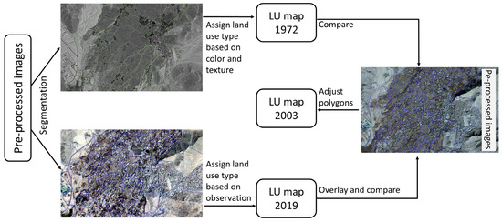
Figure 3.
Scheme of the hybrid method to classify land use (LU) types at small scale using QGIS 3.8 and images sources from Google Pro 7.1 and Corona images from the U.S. Geological Survey’s Earth Resources Observation and Science.
From black and white Corona aerial photographs of Leh in 1972 and Diskit in 1974, the Residential Area (Urban) class was extracted from discontinuously light coloured or bright pixels; dense dark patches were identified as natural vegetation and grey patches as agricultural area. Irregular patches/shapes that differed from grey patterns were treated as bare soil or rock. Dark patches without shape/line patterns reflected snow or water in the class of Others. Classification errors were estimated at <3% using a high-resolution Corona dataset [1,25]. The image processing was conducted using QGIS 3.12 and ArcGIS 10.8 software.
2.3. Household Survey
In Leh and Diskit 38 and 40 households, respectively, were interviewed about general demographic characteristics, agricultural practices, and their perceptions of tourism. The primarily qualitative survey relied on a snowball sampling approach [27] since residential lists were unavailable. This also prevented the use of proportional sampling and pre-determination of the sample size. Consequently, we opted for interviewing an equal number of households in each location. Households were selected based on their involvement in agriculture and whether they had kept livestock since at least the 1970s. In August and September 2019, interviews were conducted with the help of local translators; only respondents giving their verbal consent to participate were interviewed. The freeware Census and Survey Processing System (CSPro) [28] was used for data recording. The questionnaire consisted of four parts, namely socio-economic details (29 questions), agricultural and horticultural crops (30 questions), livestock husbandry (22 questions), and perception of tourism (6 questions). The latter was captured through a series of Likert scale options. Each interview lasted between 60 and 90 min. Afterwards the interviewees received a traditional ceremonial white scarf as a gesture of gratitude. Directly after each interview, ca. 15 min were spent on entering handwritten side notes into the software and on correcting translation errors.
Socio-economic data was gathered either at the household or individual level for adult family members only, here defined as any person living under the same roof and being at least 18 years old. With regard to cropping activities, sizes of land holdings measured in the local areal unit kanal were converted into hectare (ha) using the official conversion factor from the Statistical Handbook [29]. Data were collected on crops planted and marketed, use of fertilizers and agrochemicals, and crop irrigation. With respect to livestock keeping, questions addressed species kept and animal number per species in 2019 and 20 years ago (1999), livestock management, and marketing of animals and their products.
2.4. Survey Data Analysis
From CSPro, the interview data was imported into Microsoft Excel 2001 [28] and analysed using descriptive statistics (means, standard deviations, frequencies) [30], plotting bar charts and boxplots for graphical representation. Unless mentioned otherwise, results for binomial and categorical variables are reported in absolute (n) or relative (%) frequencies for Leh and Diskit (abbreviated as L and D when in parenthesis). For continuous variables data are depicted as arithmetic means ± one standard deviation.
3. Results and Discussion
3.1. Same Urbanization Trend but Different Spatial Allocation of Land in Leh and Diskit
Urban growth in Ladakh is constrained by rugged terrain, concentrating development on limited plains near water sources. Here, residential areas increased eightfold in Leh and doubled in Diskit over the past five decades (Figure 4, Table 3), reflecting similar urbanization effects across the region. The land use classes Others and Natural Vegetation declined moderately in Leh, where natural vegetation cover was consistently low, but decreased sharply in Diskit (Section 3.2), where it initially exceeded 10%. From 1972/74 to 2018/2019, cultivated land in Leh decreased from 50% to 30%, while in Diskit it increased from 44% to 65%, with most changes occurring before 2003 in Leh and before 2002 in Diskit. Spatially, Leh’s expansion radiated from existing residential areas in all directions, whereas in Diskit it remained closer to existing residential zones, often occupying marginal lands.
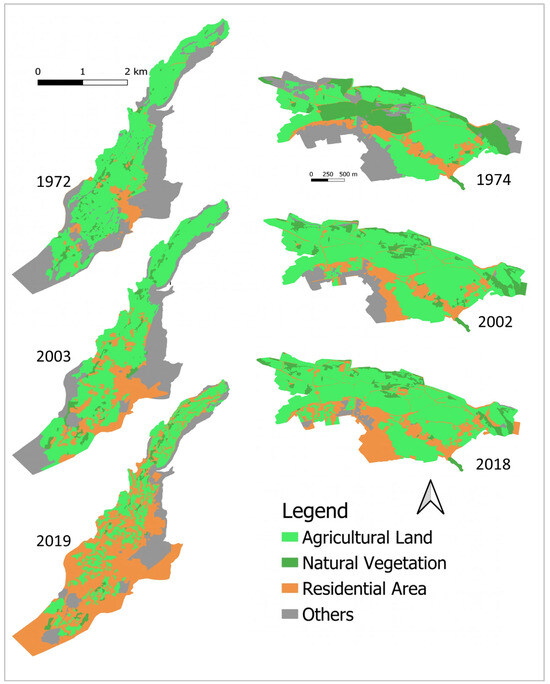
Figure 4.
Substantial expansion of residential areas in the territory of Leh (left) and slight residential expansion in Diskit (right), Ladakh, Himalayan India, as classified from Google Earth 2021 and Corona datasets (for details refer to Table 1).
Table 3.
Temporal changes in the share of distinguished land use classes at the sites of Leh and Diskit in Ladakh, Himalayan India, between 1972 and 2019.
As emerged from the household survey (Table A1 and Table A2—Appendix A), the inhabitants of both sites showed similar education and religious profiles, except for a longer high-school education in Leh (21%) than in Diskit (8%). The main driver of the divergent trends was the site’s accessibility by the opening of the Srinagar–Leh road (1962) and the Food Grain Program in the 1960s, which enabled subsidized rice and wheat imports, encouraging both cash crop cultivation and conversion of farmland to urban uses for tourism [31]. Alongside tourism, military installations further contributed to urban expansion in Leh, where major land use changes also included the construction of the Kushok Bakula Rimpochee Airport (1996) and new residential and administrative quarters, increasing pressure on remaining land [31,32]. An increase in the number of residents may also have been a contributing factor, though the lack of available census data made it impossible to confirm.
3.2. Transformation and Spatial Allocation of Land Strongly Dependent on Local Preferences and Socio-Economic Conditions
Natural vegetation and unused land (Other) were first converted into agricultural fields, while recently, a large proportion of both agricultural land and Others was transformed into residential areas (Figure 5). In Ladakh, the traditional settlement structure is characterized by a spread of residential quarters, with each household’s dwelling usually surrounded by family-owned and -operated fields [33]. Thus, traditional residences were isolated from each other with farm lands in-between. The proliferation of new urban entities that cater to the specific needs of tourists, such as “home stays”, has led to the sprouting of new urban elements on former farm lands close to the already existing residential houses. During the first three decades following the opening of the area to tourism (1970 to 2000), only little conversion of agricultural to urban land was observed, likely caused by an initially slow rise of tourism. However, since 2000, tourism has grown exponentially with a sudden increase in the demand for urban facilities such as hotels, guesthouses, and market areas [14]. The resulting rapid urbanization was mainly affecting Leh given its airport and quickly developing hotel sector. The number of tourist accommodations increased from just 30 (1974) to 190 (2005) and 650 (2015), of which about one third are hotels and the rest smaller guesthouses [34]. The more remote Diskit, in contrast, did not experience such a drastic conversion of agricultural to urban land because the number of tourists was and still remains much lower, although it increased substantially in the very recent past, which is reflected in similar tourism-induced transformation processes during the past 20 years (Figure 5).
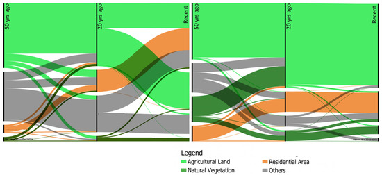
Figure 5.
Alluvial diagram detailing the transformation of land use classes in Leh (left) and Diskit (right), in Ladakh, Himalayan India, as classified from 2021 Google Earth 2021 and Corona datasets.
The survey data (Table A1) confirm that farms in Diskit possess more than twice the arable land compared to those in Leh—averaging 0.85 ha (±0.86) in Leh and 2.01 ha (±1.79) in Diskit—with pasture areas nearly five times larger in Diskit. While households in Leh tend to grow slightly more vegetables, barley cultivation was more common in Diskit. Marketing patterns also differ: in Leh, households typically sold 26–50% of their harvest, whereas in Diskit most marketed 76–100% of their produce. Irrigation water sources also differed, with glacier meltwater used more frequently in Leh and river water more in Diskit, while groundwater pumping was considerably more common in Leh than in Diskit. Among the crops, barley (Hordeum vulgare L.) and wheat (Triticum aestivum L.) were planted by 18% and 17% of the households in Leh (L) and by 29% and 15% in Diskit (D), alongside with vegetables (L: 43% of households, D: 38%) such as potato (Solanum tuberosum L.), tomato (Solanum lycopersicum L.), carrot (Daucus carota subsp. sativus (Hoffm.) Schübl. & G.Martens), onion (Allium cepa L.) as well as different species of cabbage (subspecies of Brassica oleracea L.). In addition, most households grew fruit trees (L: 22%, D: 19%), mainly apple (Malus domestica Borkh.), apricot (Prunus armeniaca L.), and walnut (Juglans regia L.). In line with the cropping practices, 68% and 58% of the households in Leh and Diskit, respectively, identified vegetables as their most important crops. Although farmers at both sites depend mainly on agriculture as an income source (Table 4), the growing demand from tourism and improved accessibility in Leh led to the conversion of over 50% of agricultural land into guesthouses and small garden plots focusing on vegetable production between 1972 and 2019 (Figure 5) [3,35].
Table 4.
In come sources of agricultural households in Leh (n = 38 households) and Diskit (n = 40 households), Ladakh, Himalayan India, as reported in a survey. Multiple answers were possible.
3.3. Agricultural Practices Reconcile Local Constraints with New Opportunities
From the interviews, it appeared that households in Leh focused more on income generation while those in Diskit referred more to tradition when asked for the main reasons for practicing agriculture. The interviewees’ major reasons for practicing agriculture were the production of food for the family, income generation, tradition, the love for farming, but also a lack of alterative income sources. Leh’s smaller cultivated land units (<0.1–0.5 ha; 75% < 4.0 ha) limit the adoption of heavy machinery and mineral fertilizers, resulting in only a moderate shift toward highly commercial crops compared to Diskit. However, farmers in the latter site currently face a more severe labour shortage, which is also projected to persist in the future (Table A2). Across both sites, farmers largely maintain traditional “organic” practices using manure, compost, and night soil, which is similar to the farming practices in neighbouring Gilgit-Baltistan [36]. Overall, agriculture remains important for livelihood diversification, food security, and cultural heritage. While local market sales are not always tourism-driven, many products ultimately supply tourist facilities. Some families prefer bulk sales to the military, especially for crops like potatoes, to reduce the need for marketing labour.
Perceptions of tourism varied between the two sites (Figure 6). European and North American visitors were viewed positively in both locations, with higher approval rates in Leh (95% and 84%) than in Diskit (73% and 63%), respectively, while visitors from other parts of India were perceived sceptically (D: 50%; L: 82%). This was partly due to concerns over cultural loss (D: 29%; L: 10%), even though also positive cultural exchange with tourists was mentioned by households in Leh (21%).
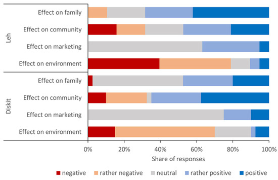
Figure 6.
Perceived effects of tourism on the own family, the community, the marketing of agricultural goods, and the environment in Leh (n = 38) and Diskit (n = 40), Ladakh, Himalayan India, in 2019. Only one response per interviewee and category was accepted.
Although the overall economic importance of livestock to households in Leh and Diskit remains smaller than that of crops and livestock numbers were reportedly decreasing from 1999 to 2019 (Figure 7), the tourism boom has encouraged specialization in and expansion of bovine milk production in Leh, at the expense of small ruminant (meat) production. Since milk is in high demand by Hindu tourists with predominantly vegetarian diets [37], the changes in Leh’s livestock sector reflect the influence of the large number of Indian tourists among the annual visitors. In Diskit, where tourism plays a lesser role, small ruminant rearing and the trade of live animals for slaughter have remained important economic activities, even though the number of families engaged in small ruminant husbandry has also declined (Table A2).
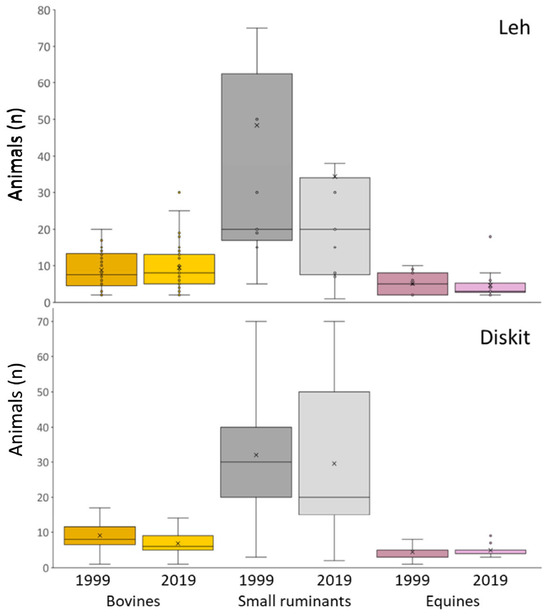
Figure 7.
Household-level herd composition in Leh (above) and Diskit (below) in Ladakh, Himalayan India. Only livestock keeping households are considered, namely 26 (1999) and 28 (2019) in Leh and 18 (1999) and 40 (2019) in Diskit. The lower and upper quartiles limit each box, the median is represented by the horizontal line, the mean by the tick, minimum and maximum by the lower and upper whisker, and outliers are marked by dots. For Diskit, the plot does not show two small ruminant herds with ≥150 animals in 1999 and one in 2019.
Tourism in Ladakh has improved well-being, particularly among poorer households [38], and stimulated market-driven agricultural intensification, in contrast to places like Nepal, where economic growth often leads to agricultural abandonment [39]. The persistence of crop and livestock production despite resource degradation driven by land use and climate change [40] reflects the adaptability of local communities in transforming traditional livelihoods. Overall, the findings underscore the need for culturally sensitive and environmentally responsible tourism development that supports local communities by sustaining their agri-cultural livelihoods [41,42].
3.4. Importance of Downscaling in Land Allocation Assessment and Its Driving Factors: Implications for Further Research
Although this study combines time-series land use classification for two study sites of unequal size with a relatively small household survey, it shows that local-scale assessments, supported by household-level data, can effectively capture land use trends. This approach therefore offers a valuable alternative to the dominant focus on large-scale analyses using AI, machine learning, and advanced classification techniques, especially if the focus is on analysing local developments. Understanding community-level and even individual decisions can uncover how human perceptions and related activities shape and transform landscapes in a significant manner [43]. Using freely available open-access resources, our downscaled approach provided a nuanced understanding of the current challenges and opportunities faced by Ladakh’s highland communities as they transition from predominantly agro-pastoral societies to urbanization-driven lifestyles. However, our ability to fully disentangle the drivers of land use change was limited. On the survey side, this relates to the fact the non-agricultural households were not addressed. With respect to the analysis of land transformation, the integration of active remote sensing data, such as radar or LiDAR, could have provided deeper insights into changes in ecosystem services and local biodiversity [44]. Furthermore, a modelling approach could be applied to test scenarios such as ecotourism zoning and current business practices to assess trade-offs between prioritizing high-income options safeguarding ecosystem services as well as food demand. Beyond assessing the effects of transformation on local ecosystems and cultural identity, time-series studies such as ours can strengthen the basis for informed land use policy in a major water tower region that, besides serving the livelihoods of its residents and attracting tourists, hosts the upper Indus River—a critical water source for Asia’s growing lowland populations.
4. Conclusions
This study provides a spatially explicit case of a high mountain region undergoing rapid rural–urban transformation in an increasingly telecoupled world. Although Leh and Diskit share a similar socio-economic history, divergent land allocation trajectories emerged over the past almost 50 years, driven by the massive influx of tourists and the continued presence of the Indian Armed Forces. Our findings qualitatively demonstrate that tourism and military presence are the two primary drivers of divergent land use trajectories in Leh and Diskit, shaping both the pace and scale of rural–urban transformation. Leh has experienced substantial conversion of agro-pastoral land to urban use, while Diskit has seen more localized and small-scale change. These urbanization-induced land use transitions are mirrored in the modernization of agro-pastoral livelihoods and cultural landscapes, though with varying intensity across the two study sites. In all transformation processes, local residents maintain a resilient core of traditional practices, adapting them to new market opportunities, particularly in tourism. More detailed household surveys and stakeholder perspectives should be incorporated in future research to better capture decision-making dynamics and long-term livelihood strategies. Ladakh’s transformation processes thus offer valuable insights for integrated spatial planning that aims at balancing economic growth with cultural heritage and ecosystem services in mountain regions facing similar pressures from globalization.
Author Contributions
Conceptualization, A.B. and E.S.; methodology, E.S. and T.T.N.; software, T.T.N.; validation, E.S. and T.T.N.; formal analysis, I.H., M.I., E.S. and T.T.N.; investigation, I.H. and M.I.; resources, A.B.; data curation, E.S., I.H., M.I., M.W. and T.T.N.; writing—original draft preparation, E.S., M.I., M.W. and T.T.N.; writing—review and editing, A.B., K.N.G., M.W. and T.T.N.; visualization, E.S. and T.T.N.; supervision, A.B. and E.S.; project administration, A.B.; funding acquisition, A.B. All authors have read and agreed to the published version of the manuscript.
Funding
This work was supported by the German Academic Exchange Service (DAAD) via PROMOS scholarships assigned by the University of Kassel (Germany) to Imke Hellwig and Maximilian Ibing.
Informed Consent Statement
This study was conducted in accordance with the ethical guidelines and principles of the University Ethics Committee of the University of Kassel, Germany. Ethical approval for this research was obtained from the chairperson of the committee under the reference number z-EK-104. All participants in the study received a full explanation of the research objectives and interview procedures. Oral informed consent was obtained from all participants prior to their inclusion in the study. Participants were assured that their participation was voluntary and that they could withdraw from the study at any time without consequence, and measures were taken to ensure the confidentiality and anonymity of participants’ data.
Data Availability Statement
The anonymized dataset of the interviews on which this article is based is publicly available via the institutional repository of the University of Göttingen at: https://data.goettingen-research-online.de/dataset.xhtml?persistentId=doi:10.25625/JT4CRW. All other data are derived from public domain resources.
Acknowledgments
We are indebted to Farooq Khan, University of Leh (India), Mohamed Iqbal, Chief Animal Husbandry Officer, Leh (India), and to Mazoor Ahmed Shah, Department of Botany, University of Kashmir, Srinagar (India), for their scientific advice and institutional support during field work. The latter work would certainly not have been possible without the tireless help of Jigmet Ihundup and Wangmo Chamba from Leh, our guides and translators, whose generosity was exemplary for the Ladakhi people, as well as all respondents who patiently shared their time, trust, and hospitality with us. We also thank the German Academic Exchange Service (DAAD) and University of Kassel (Germany) for PROMOS scholarships to Imke Hellwig and Maximilian Ibing. We used Chatgpt 5.0 (assessed in August 2025) to identify grammar mistakes and improvement of syntax consistency. All corrections and suggestions were carefully read and revised. We confirm there was no use of AI for generating ideas, or text.
Conflicts of Interest
The authors declare no potential conflicts of interest with respect to the research, authorship, and/or publication of this manuscript.
Abbreviations
The following abbreviations are used in this manuscript:
| LU | Land Use |
| L | Leh |
| D | Diskit |
Appendix A
Table A1.
Summary of the household (HH) survey results in Leh (n = 38) and Diskit (n = 40), Ladakh, Himalayan India.
Table A1.
Summary of the household (HH) survey results in Leh (n = 38) and Diskit (n = 40), Ladakh, Himalayan India.
| Category | Leh (L) | Diskit (D) | Main Difference |
|---|---|---|---|
| Average arable land/HH | 0.85 ha ± 0.86 | 2.01 ha ± 1.79 | Diskit farms are more than twice as large as farms in Leh. |
| Actively cultivated land | 0.35 ha ± 0.51 | 0.58 ha ± 0.44 | Diskit cultivates more area. |
| Pasture area | 0.19 ha ± 1.16 | 0.98 ha ± 0.27 | Diskit uses far more land as pasture. |
| Change in managed land (past 20 yrs) | 33/38 HH reported decrease | 32/40 HH reported decrease | Decrease common in both. |
| Main reasons for practicing agriculture | Income generation (39%), Food production (34%), Tradition (16%), No alternative (11%) | Food production (35%), Income (28%), Tradition (30%), No alternative (7%) | Leh focuses more on income, Diskit more on tradition. |
| Main crops grown | Barley 18%, Wheat 17%, Vegetables 43%, Fruit trees 22% | Barley 29%, Wheat 15%, Vegetables 38%, Fruit trees 19% | Barley more in Diskit, vegetables slightly more in Leh. |
| Most important crop (self-reported) | Vegetables—68% of HH | Vegetables—58% of HH | Vegetables more important in Leh. |
| Adults in agriculture per HH | 3.6 ± 1.1 | 2.9 ± 1.3 | More agricultural labour available in Leh. |
| Hours per person/month in agriculture | 88 ± 62.7 | 83 ± 66.7 | Slightly higher labour input in Leh. |
| Top cropping activities | Weeding vegetables (26%), Ploughing cereals (25%), Flood irrigation (21%) | Cereal harvest (30%), Ploughing (21%), Irrigation (12%) | Focus on vegetables in Leh, cereals in Diskit. |
| HH hiring labour | 31 HH; 6.3 ± 4.8 persons; 5.3 ± 6.1 days/year | 24 HH; 4.6 ± 2.6 persons; 2.6 ± 5.3 days/year | Leh hires more farm workers for longer periods. |
| Fertilizer use | 13 HH use mineral fertilizers; pesticides in vegetables, herbicides in wheat/barley (1 HH) | 7 HH use mineral fertilizers; pesticides in vegetables, herbicides in wheat/barley (10 HH) | Herbicide use far higher in Diskit than in Leh. |
| Irrigation sources | River water pump 37%, Glacier melt water streams 47%, Borehole + mix 16% | River water pump 50%, Glacier melt water 30%, Borehole + mix 20% | More river water pumping in Diskit, more glacier water use in Leh. |
| Change in water availability | 39% pump more groundwater than formerly; 53% report no changes | Only 1 HH pumps more water than formerly; 75% report no changes | Groundwater pumping concerns are much higher in Leh. |
| Crop sales | 20 HH sell crops, with vegetables as main commodity; 49% HH market 26–50% of their harvest; 22% market 76–100% | 26 HH sell crops, with vegetables main commodity; 13% HH market 26–50% of harvest; 71% market 76–100% | Diskit sells a higher share of the vegetable harvest than Leh. |
| Sales outlets | Local market 50%, Army 36%, Hotels/restaurants 14% | Local market 60%, Army 23%, Hotels/restaurants 13% | Local markets more important in Diskit, army sales more important in Leh. |
Table A2.
Main characteristics of the surveyed households (HH) in Leh (n = 38) and Diskit (n = 40) in Ladakh, Himalayan India, in 2019.
Table A2.
Main characteristics of the surveyed households (HH) in Leh (n = 38) and Diskit (n = 40) in Ladakh, Himalayan India, in 2019.
| Variable | Leh | Diskit |
|---|---|---|
| Adult HH members (n) | 4.0 ± 1.17 | 3.7 ± 1.29 |
| Female HH members (%) | 47.9 ± 18.46 | 45.2 ± 13.98 |
| Age of HH head (years) | 63.2 ± 13.20 | 53.5 ± 16.10 |
| Average age of adult HH members (years) | 48.6 ± 8.80 | 45.7 ± 10.53 |
| Members with formal education (%) | 86.3 ± 15.31 | 72.6 ± 23.51 |
| HH keeping livestock (2019) | 28 of 38 | All HH |
| HH keeping livestock (1999) | 26 of 38 | 18 of 40 |
| Small ruminant keepers (1999 → 2019) | 73% → 25% | 72% → 23% |
| Equine keepers (1999 → 2019) | 69% → 39% | 61% → 35% |
| Main past problem | Predation (16%), fodder shortage (8%) | Predation (38%) |
| Main present problem | Labour shortage (29%), predation (16%), fodder shortage (13%) | Labour shortage (38%), predation (18%) |
| Future main concern | Labour shortage (56%), cultural change (56%) | Labour shortage (58%), cultural change (58%) |
References
- Fastner, K.; Djibrilla, S.; Nguyen, T.; Buerkert, A. Telecoupled Urban Demand from West African Cities Causes Social-Ecological Land Use Transformation in Saharan Oases. PLoS ONE 2023, 18, e0289694. [Google Scholar] [CrossRef] [PubMed]
- Dolma, Y. Tourism in Ladakh: Trends, Opportunities and Challenges. Int. J. Sci. Eng. Res. 2019, 10, 979–986. [Google Scholar]
- Dame, J.; Schmidt, S.; Müller, J.; Nüsser, M. Urbanisation and Socio-Ecological Challenges in High Mountain Towns: Insights from Leh (Ladakh), India. Landsc. Urban Plan. 2019, 189, 189–199. [Google Scholar] [CrossRef]
- Ministry of Law and Justice (Legislative Department). The Farmers’ Produce Trade and Commerce (Promotion and Facilitation) Act, 2020; Gazette of India: New Delhi, India, 2020; CG-DL-E-27092020-222039.
- Singh, J.S. Sustainable Development of the Indian Himalayan Region: Linking Ecological and Economic Concerns. Curr. Sci. 2006, 90, 784–788. [Google Scholar]
- KC, K.B.; Tzadok, E.; Pant, L. Himalayan Ecosystem Services and Climate Change Driven Agricultural Frontiers: A Scoping Review. Discov. Sustain. 2022, 3, 35. [Google Scholar] [CrossRef]
- Bhasin, V. Pastoralists of Himalayas. J. Biodivers. 2013, 4, 83–113. [Google Scholar] [CrossRef]
- Bhasin, V. Ecology and Health: A Study Among Tribals of Ladakh. Stud. Tribes Tribals 2005, 3, 1–13. [Google Scholar] [CrossRef]
- Bhasin, M. Cold Desert: Ladakh. Ecology and Development; Kamla-Raj Enterprises: Delhi, India, 2020. [Google Scholar]
- Bhattacharyya, A. Vegetation and Climate during the Last 30,000 Years in Ladakh. Palaeogeogr. Palaeoclimatol. Palaeoecol. 1989, 73, 25–38. [Google Scholar] [CrossRef]
- Thayyen, R.J. Hydrology of the Cold-Arid Himalaya. In Himalayan Weather and Climate and their Impact on the Environment; Dimri, A.P., Bookhagen, B., Stoffel, M., Yasunari, T., Eds.; Springer International Publishing: Cham, Switzerland, 2020; pp. 399–417. ISBN 978-3-030-29684-1. [Google Scholar]
- Fisher, M.W.; Rose, L.E.; Huttenback, R.A. Himalayan Battleground: Sino-Indian Rivalry in Ladakh; Library of Congress Catalog Card Number: 63-11121; Frederick A. Praeger: New York, NY, USA; London, UK, 1963. [Google Scholar]
- Aggarwal, R. Beyond Lines of Control: Performance and Politics on the Disputed Borders of Ladakh, India; Duke University Press: Durham, NC, USA, 2004; ISBN 978-0-8223-3428-6. [Google Scholar]
- Jina, P.S. Ladakh. The Land and the People; Indus Publishing Company: New Delhi, India, 1996. [Google Scholar]
- Dolma, Y. Impact of Tourism on the Economy of Ladakh Region of the Jammu and Kashmir State of India. Ph.D. Thesis, Department of Economics, Panjab University, Chandigarh, India, 2020. [Google Scholar]
- Ahuja, A.; Kapur, D. Internal Security in India: Violence, Order, and the State; online edn.; Oxford Academic: New York, NY, USA, 2023. [Google Scholar]
- Bhatnagar, Y.; Wangchuk, R.; Mishra, C. Decline of the Tibetan Gazelle Procapra Picticaudata in Ladakh, India. Oryx 2006, 40, 229–232. [Google Scholar] [CrossRef]
- Bhatnagar, Y.V.; Wangchuk, R.; Prins, H.H.T.; Van Wieren, S.E.; Mishra, C. Perceived Conflicts between Pastoralism and Conservation of the Kiang Equus Kiang in the Ladakh Trans-Himalaya, India. Environ. Manag. 2006, 38, 934–941. [Google Scholar] [CrossRef]
- Goodall, S. Changpa Nomadic Pastoralists: Differing Responses to Change in Ladakh, North-West India. Nomadic Peoples 2004, 8, 191–199. [Google Scholar] [CrossRef]
- Thiksay, T.N. To analyze the tourism industry of India with special reference to Leh District of Ladakh Union Territory. Int. J. Dev. Res. 2020, 10, 34472–34477. [Google Scholar] [CrossRef]
- Radhu, S. A Study on The Socio-Economic Impacts of Eco Tourism in Ladakh, India. Int. J. Multidiscip. Res. 2023, 5, 1–9. [Google Scholar]
- Smanla, T. Ecotourism in Ladakh: A Critical Aspect to Contemplate. Int. J. Res. Publ. Rev. 2022, 3, 2096–2105. [Google Scholar]
- Harrison, B. The Impact of a Tourism Boom in an Environmentally-Sensitive Region: A Case Study of Ladakh (Kashmir, India). Jpn. J. Policy Cult. 2021, 29, 21–41. [Google Scholar]
- Lone, I.U.; Mishra, M.; Tiwary, S.K.; Chandra, R. Recognition of Shyok Ophiolites of NW Ladakh Trans-Himalaya as a Geoheritage: Importance to Himalayan Orogeny and Remnant of Tethyan Oceanic Lithosphere. Geoheritage 2022, 15, 3. [Google Scholar] [CrossRef]
- Lillesand, T.M.; Kiefer, R.W. Remote Sens Ing and Image Interpretation, 4th ed.; Wiley: New York, NY, USA, 2000. [Google Scholar]
- Woodcock, C.E.; Loveland, T.R.; Herold, M.; Bauer, M.E. Transitioning from Change Detection to Monitoring with Remote Sensing: A Paradigm Shift. Remote Sens. Environ. 2020, 238, 111558. [Google Scholar] [CrossRef]
- Goodman, L. Snowball Sampling. Ann. Math. Stat. 1961, 32, 148–170. [Google Scholar] [CrossRef]
- US Census Bureau Census and Survey Processing System (CSPro) 2020; United States Census Bureau: Sutland, MD, USA, 2020.
- Statistical Handbook 2017; District Statistics and Evaluation Office: Kargil, Ladakh, India, 2017. Available online: https://dseokargil.ladakh.gov.in/statshandbook.html (accessed on 14 October 2025).
- Stern, R.; Coe, R.; Allan, E.; Dale, D. Good Statistical Practice for Natural Resources Research; CABI publishing: Wallingford, UK, 2004; ISBN 0-85199-722-8. [Google Scholar]
- Dolker, P. An Overview of Transition in Traditional Agriculture of Ladakh. J. Himal. Ecol. Sustain. Dev. 2018, 13, 26–48. [Google Scholar]
- Dollfus, P. Transformation Processes in Nomadic Pastoralism in Ladakh. Himalaya J. Assoc. Nepal Himal. Stud. 2012, 32, 61–72. [Google Scholar]
- Nüsser, M.; Schmidt, S.; Dame, J. Irrigation and Development in the Upper Indus Basin Characteristics and Recent Changes of a Socio-Hydrological System in Central Ladakh, India. Mt. Res. Dev. 2012, 32, 51–61. [Google Scholar] [CrossRef]
- Government of Jammu and Kashmir Statistical Handbook No. 38, 2016–2017; Ladakh Autonomous Hill Development Council: Leh, India, 2017.
- Dame, J.; Nüsser, M. Food Security in High Mountain Regions: Agricultural Production and the Impact of Food Subsidies in Ladakh, Northern India. Food Secur. 2011, 3, 179–194. [Google Scholar] [CrossRef]
- Köster, M.; Alam, I.; Rana, J.; Wiehle, M.; Buerkert, A. A Stony Track towards Innovation in Remote Highland Regions: Agricultural Intensification in the Apricot Sector of Northern Pakistan. Agric. Food Secur. 2024, 13, 27. [Google Scholar] [CrossRef]
- Hirata, M. Milk Culture of South Asia. In Milk Culture in Eurasia: Constructing a Hypothesis of Monogenesis–Bipolarization; Hirata, M., Ed.; Springer: Singapore, 2020; pp. 73–106. ISBN 978-981-15-1765-5. [Google Scholar]
- Dar, S.N.; Shah, S.A.; Wani, M.A. Geospatial Tourist Information System for Promoting Tourism in Trans-Himalayas: A Study of Leh Ladakh India. GeoJournal 2022, 87, 3249–3263. [Google Scholar] [CrossRef]
- Chaudhary, S.; Wang, Y.; Dixit, A.M.; Khanal, N.R.; Xu, P.; Fu, B.; Yan, K.; Liu, Q.; Lu, Y.; Li, M. A Synopsis of Farmland Abandonment and Its Driving Factors in Nepal. Land 2020, 9, 84. [Google Scholar] [CrossRef]
- Namgail, T.; Van Wieren, S.E.; Prins, H.H.T. Pashmina Production and Socio-Economic Changes in the Indian Changthang: Implications for Natural Resource Management. Nat. Resour. Forum 2010, 34, 222–230. [Google Scholar] [CrossRef]
- Buerkert, A.; Luedeling, E.; Dickhoefer, U.; Lohrer, K.; Mershen, B.; Schaeper, W.; Nagieb, M.; Schlecht, E. Prospects of Mountain Ecotourism in Oman: The Example of As Sawjarah on Al Jabal al Akhdar. J. Ecotourism 2010, 9, 104–116. [Google Scholar] [CrossRef]
- Donohoe, H. Defining Culturally Sensitive Ecotourism: A Delphi Consensus. Curr. Issues Tour. 2011, 14, 27–45. [Google Scholar] [CrossRef]
- Turner, B.L.; Lambin, E.F.; Reenberg, A. The Emergence of Land Change Science for Global Environmental Change and Sustainability. Proc. Natl. Acad. Sci. USA 2007, 104, 20666–20671. [Google Scholar] [CrossRef]
- Boehnke, D.; Krehl, A.; Mörmann, K.; Volk, R.; Lützkendorf, T.; Naber, E.; Becker, R.; Norra, S. Mapping Urban Green and Its Ecosystem Services at Microscale—A Methodological Approach for Climate Adaptation and Biodiversity. Sustainability 2022, 14, 9029. [Google Scholar] [CrossRef]


Disclaimer/Publisher’s Note: The statements, opinions and data contained in all publications are solely those of the individual author(s) and contributor(s) and not of MDPI and/or the editor(s). MDPI and/or the editor(s) disclaim responsibility for any injury to people or property resulting from any ideas, methods, instructions or products referred to in the content. |
© 2025 by the authors. Licensee MDPI, Basel, Switzerland. This article is an open access article distributed under the terms and conditions of the Creative Commons Attribution (CC BY) license (https://creativecommons.org/licenses/by/4.0/).