Article

Regionalization of the Croatian Landscape: An Integrative Approach to Methods and Criteria for Defining Boundaries

Department of Ornamental Plants, Landscape Architecture and Garden Art, Faculty of Agriculture, University of Zagreb, Svetošimunska Cesta 25, 10000 Zagreb, Croatia
*
Authors to whom correspondence should be addressed.
Land 2025, 14(10), 2068; https://doi.org/10.3390/land14102068
Submission received: 11 September 2025 / Revised: 11 October 2025 / Accepted: 14 October 2025 / Published: 16 October 2025

Abstract

The purpose of this paper is to examine how existing regionalizations in the Republic of Croatia differ in their criteria for region separation, to identify their similarities and differences, and to outline the key characteristics of each defined region. As landscape research is broad and interdisciplinary, regionalization plays an important role in developing landscape typology. This is particularly relevant in Croatia, where landscape studies are still at an early stage, making it necessary to establish clear starting points for a unified approach in future research. The method included overlapping two landscape, four geographic, one natural, and three cultural regionalizations in two subject areas in Lika and in Bilogora and the Kalnik foothills. The results showed that there are greater similarities between regionalizations based on natural features (relief and hydrological features), while there are greater differences between cultural regionalizations, as these also include human perception of the landscape. Furthermore, there are greater similarities between regions in the Lika area, while in Bilogora and the Kalnik foothills a quite different understanding of regional boundaries through various aspects is evident. It was determined that the scope of areas carrying the identity of both regions (obtained by an intersectional methodological approach) differs from the scope of regions as perceived by the local population. In conclusion, the contemporary identity of the landscape is subject to constant review due to new scientific knowledge and changes in perception, where it is crucial to consider all available data and include the public in defining regional boundaries.

1. Introduction

Due to the multidisciplinary nature of landscape research, many different systems and methods for landscape identification and classification exist [1,2]. Addressing landscape identity within different frameworks and on different scales, as well as considering various historical, social, and environmental conditions, results in various interpretations of the concept and in its vague definition [3]. Depending on their scientific rooting, these systems and characterization methods emphasize different aspects of the landscape to variable degrees, and they address variation in landscape properties on different spatial and temporal scales [2,4,5,6]. This touches on another issue that needs to be addressed, which is where a particular landscape identity changes in the landscape [7,8], or as Antrop [9] puts it, without defining the border line there is a need to define measurable holistic and structural aspects of a landscape.
Landscape is itself an ambiguous concept built on a plurality of understandings [10] and a dynamic, multi-layered, spatial–temporal system [11]. It can also be seen as (1) layers of various meanings and interpretations [12,13]; (2) a geographic area, characterized by its content of observable, natural, and human-induced landscape elements [2]; and (3) the structure of relationships between different systems (geomorphological, ecological, environmental, cultural–historical, aesthetic, socio-economic, spatial) involving all genetic, biological, and functional relationships within elements of the land cover [13]. These different aspects create an image of landscape as a meta-organization, making the relationships between different systems and cultures palpable [10,14,15]. The landscape should therefore be approached as a complex system of different elements which, through their consequential connections, enable its functioning [16].
The complex, varied, and continuous landscape can be understood better when classified in types and spatial units [2,17,18]; that is, conceptualizing landscape begins with defining its boundaries [11]. Regardless of approach, any system for spatial landscape characterization inevitably implies a strong simplification of the almost infinite variability in landscapes, into spatial units suitable for communication in management and research [2,19,20]. Defining boundaries is always a challenge in landscape research, since landscape is a continuum, where one landscape area “blurs” into another and where boundaries depend on the point of observation and the observer’s interpretation [3,21,22]. It is necessary to distinguish between linear boundaries, i.e., crisp, sharp artificial boundaries of administrative units, and indeterminate boundaries, i.e., fuzzy, vague boundaries of natural spatial units [23,24]. Natural boundaries are based on the physical–geographical features of the land, while artificial boundaries are set arbitrarily by national governments or in border treaties between countries [24,25]. Additionally, it is important to consider that geographic boundaries are not static and that they change all the time. As boundaries change, so do the geographic entities that they bound [26,27].
The basic principle for the classification and typology of landscapes that is today accepted and promoted is the principle of landscape character, i.e., the Landscape Character Assessment (LCA) approach, which was developed in Britain and is now used in other parts of Europe [28]. It is determined by a specific combination of geology, relief, soil, vegetation, land use, field, and settlement patterns. Landscape characterization and assessment methods are tempting approaches for capturing spatial interpretations of the landscape and its characteristic features and delivering them to land use planners and a larger public. These methods aim at dealing with the holistic nature of the landscape and convey an understanding of its unique features [29]. Thus applied, the principle of character allows us to define certain types of landscapes, known as clear landscape units of relatively homogeneous character [30,31]. Landscape character often reflects the state and quality of the landscape and informs planners on how to manage and maintain the landscape [28]. In countries where landscape diversity is an important feature, research on landscape types also strengthens national identity [32,33]. Landscape typologies and geographical regionalizations are often part of geography textbooks at all levels of education, which means that practically everyone gets to know them [33,34]. The challenge remains in generating a unified representation of landscape characteristics based on the existing multi-attribute elements of the landscape [33]. We need both natural and social sciences, as well as humanities, mainly aesthetics, to identify the character and the transformation of landscapes [11].
Closely related to these are the terms region and regionalization (from lat. Regiō ”region, place, border” [34,35]. They can be combined into the following definition: regionalization is the process of dividing territory into regions and their hierarchical classification [36], and the purpose of regionalization is to delineate regions based on criteria tending towards homogeneity, equality, and contiguity [37,38]. Although regions often appear to be static and fixed spatial entities, one of their important characteristics is their dynamism and changeability as a consequence of changes in the spatial structures and processes by which they are defined or in changes in their perceptions by those who participate in shaping regions. In contemporary geographic research, the region is now dominantly considered a social construct and a social process [39], “the way we “see” what constitutes space, and also the way we organize ideas and knowledge about the world” [40]. The idea of regional identity has been implicit in geography for a long time, since traditional approaches to regions and regionalism often celebrate the primordial nature of regions, accentuating their “personality” and the harmony/unity between a region and its inhabitants [41]. Regional identity has been recognized as a key element in the making of regions as social/political spaces, but it is difficult to elucidate what this identity consists of and how it affects collective action/politics [41,42,43].
On the other hand, landscape identity is a concept that is rarely well defined, lacks clarity, and is open to a variety of interpretations, all of which make it difficult to discuss it scientifically, and it is often simply regarded as the sum of those factors that makes one region dissimilar to another region [8]. Within landscape studies, landscape identity has traditionally been treated as the visual and physical character of the landscape [44,45,46], exemplified in practice through landscape characterization [46,47].
Stobbelaar and Pedroli [8] conclusively defined landscape identity as the “perceived uniqueness of a place”, and as such, it belongs as much to the observer as to the area. A form of landscape identity, defined by the latter authors, is cultural–spatial landscape identity that can be characterized by those features that distinguish one region from another [48]. The focus is on features that can principally be perceived in the landscape by everyone, such as spatial composition, land use, wildlife, vegetation and minerals, the colors, forms and patterns, the use of building materials, etc. The discussion on landscape character assessments [4] also strongly refers to the cultural–spatial landscape identity; thus, the application of this concept is strongly focused on regional spatial identity [8].
For the purposes of this research, two geographically distinct regions in Croatia were selected. The first is “Bilogora and the Kalnik foothills”, an area that is not recognized as a separate cultural region but is located on the border of several larger Croatian regions (Hrvatsko Zagorje, Podravina, Slavonia, etc.) to which it does not belong according to the landscape type. It forms a separate entity in terms of relief located between neighboring hills and river plains, and the problem of drawing the exact borders of the region is highlighted. The second region is “The Central part of Lika”, recognized at the level of the Republic of Croatia as a cultural region, but different experts perceive its borders differently because the very dynamic configuration of the terrain makes it impossible to understand the borders unambiguously. Lika was chosen as a representative example of the landscape of Mountainous Croatia, the smallest and least explored landscape macroregion. It stands out regionally due to its natural values and cultural recognizability.
Therefore, based on theoretical assumptions, the main objectives of this work have been defined as follows:
  • Determine which parts of the studied regions are represented in all analyzed regionalizations; that is, which parts of the landscape region contain the key landscape features.
  • Show similarities and differences in approaches to determining the boundaries of the two regions and identify which landscape features (criteria) all authors agree are the bearers of identity.
  • Determine to what extent the listed criteria coincide with those defined by the Landscape Character Assessment (LCA of the Republic of Croatia (2024) as relevant for the regional scale).

2. Materials and Methods

2.1. Research Area

2.1.1. Bilogora and the Kalnik Foothills

This region extends across the northern part of Croatia from northwest to southeast, bordered by hills (Medvednica in the west, Kalnik in the northwest, and the Slavonian Highlands in the southeast) and river plains (Podravina in the northeast and the Ilova, Lonja, and Česma basins in the southwest) (Figure 1). The landscape features wooded and cultivated ribbed hills with small stream valleys and scattered settlements, alternating with wooded slopes of the lower mountains. The region is characterized by a low, elongated, and indented landform covered with tall forest vegetation in the higher areas, which transitions toward the foothills into a pattern of smaller forest complexes, meadows, and smaller settlements interspersed with mosaics of agricultural land.

2.1.2. The Central Part of Lika

This region is located in central Croatia, between Velebit in the west and Lička Plješevica and Kapela in the east (Figure 1). The central part of the Lika plateau is characterized by the alternation of the lower, highly dissected chain of the Lika central highlands covered by forest vegetation, with large, cultivated karst fields subject to periodic flooding and numerous watercourses that sink at the contact between permeable and impermeable rocks. The area is extensive with a highly dynamic configuration, where the prominent hills and foothills of natural origin alternate with anthropogenic planar elements of karst fields at their base.

2.2. Overview of Analyzed Regionalizations

Although it would be desirable to examine the regionalizations of all factors that define the character of the landscape, this research used only (1) publicly available data, (2) data on regionalizations developed at the level of the entire Republic of Croatia, or (3) data available in the form of maps, with the exception of the historical–geographical region of Lika, which was prepared as part of the research, based on the description of its scope.

2.2.1. Landscape Regionalizations

The first landscape regionalization of Croatia [49] was based on natural features (Table 1), dividing the territory of the Republic of Croatia into three main natural–geographic regions, which were Adriatic/Coastal, Pannonian, and Mountainous Croatia, or into 16 smaller landscape units.
The LCA of the Republic of Croatia [50], developed in 2024, is the first comprehensive document that systematically recognizes, analyzes, and evaluates landscapes at the national level. Developed in accordance with the obligations assumed by the ratification of the Council of Europe Landscape Convention [51], this document views landscape as a key element of spatial identity and quality of life, as well as an important resource for sustainable development. It also assessed landscape character at the macro-regional (M 1:250,000) and regional (M 1:250,000–1:100,000) levels. For this research, regional-level landscape units (Bilogora and Kalnik foothills, the central part of Lika) obtained from this landscape study were used.
Table 1. List of reviewed regionalizations.
RegionalizationCriteria
Landscape regionalizations
Landscape regionalization according to Bralić (1995) [49]Relief
Water
Vegetation
LCA of the Republic of Croatia (2024) [50](Hydro)geology
Hydrology
Relief
Cultural regions
Land cover (CLC)–first level
Forest vegetation
Geographical regionalizations
Natural-geographical regionalization [52]Morphostructural and morpholithogenic elements are key for regional differentiation, but in individual cases, the prevailing relationship of climatic, hydrological, biogeographic, and pedological elements was also of great importance.
Geographic regionalization [53]Natural basis
Specificities of socio-economic structures in the regions
Conditionally homogeneous
regionalization [54]
Grouping economically relevant criteria of relief structure, climatic–ecological characteristics, and processes of historical–geographical development expressed in types of population structure related to ethnographic and economic characteristics.
Conditionally homogeneous
regionalization [55]
It is based on the principle of “conditional uniqueness of individual Croatian spatial units”.
Natural regionalization
Geomorphological regionalization of Croatia [56]Relief
Hydrology
Cultural regionalizations
Regionalization of Croatian traditional architecture [57]Natural factors: (1) geological composition of the soil, (2) vegetation cover, (3) climate, and (4) terrain configuration.
Social factors: (1) economic activity of the population, (2) family structure, (3) social and political system, (4) population migration, (5) transport connections and therefore external influences, (6) public safety, (7) religion, etc.
Agricultural regionalization [58]Similar geographical–climatic features
Predominant land use
Historical–geographical region [59]The Miroslav Krleža Lexicographic Institute is the central Croatian lexicographic institution. The encyclopedias, atlases, dictionaries, lexicons, and bibliographies of the Lexicographic Institute are traditionally reliable and interpret facts from Croatian heritage and social reality in a recognizable way.

2.2.2. Geographical Regionalizations

Geographic regionalizations view space in its entirety, with all its natural and social components, and they combine many different criteria in order to single out geographic regions based on their predominant characteristics [50]. Roglić (1963) [60] points out that the geographic concept of a region is determined by the existence of real, objectively existing units of spatial reality, which are structurally homogeneous geographic regions. They are, according to the author, the result of a combination of socially transformed elements of the natural complex and social factors [60]. Table 1 presents four geographic regionalizations of Croatia, created in the period from the 1970s to the present day. They illustrate different approaches and principles of regionalization in geography or changes in the spatial coverage of individual regions in the same types of regionalizations over time.

2.2.3. Natural Regionalization

Of the natural regionalizations, only the geomorphological one was analyzed [56], given that there were no adequate data for other natural factors (water, surface cover, etc.) in the specified scale (M 1:250,000–1:100,000) (Table 1).

2.2.4. Cultural Regionalizations

Within the framework of cultural regionalizations, three key data sources important for understanding anthropogenic landscape characteristics at the regional level were reviewed. The first was agricultural regionalization according to Defilippis [57], which is so far the only regional division of the agricultural area of the Republic of Croatia. The second was the regionalization of Croatian traditional architecture according to Živković [58], following Sorre’s [61] conception of habitat as a cultural response to environmental settings, where traditional architecture is seen as a key element in understanding landscape typology. The last was the historical–geographic regionalization according to the Central Croatian Lexicographic Institution, representing a vernacular region, which is a space of homogeneous characteristics that differs from the surrounding area in these characteristics, and which does not have any formal criteria [62,63,64] but rather exists from individual to individual. That is, such regions are most often determined by individuals on the basis of cultural, historical, and political characteristics [64].

2.3. Methods

The research began with an analysis of the scientific and professional literature on landscape typology, regionalization, and landscape characterization. A condition for including certain regionalizations in the analysis of the regions in question was that their names contained the terms “Lika” (for “The Central part of Lika”), “Bilogora”, or “Kalnik” (for “Bilogora and the Kalnik foothills”), as these are the basic toponyms by which these regions are recognized.
Furthermore, the research required the collection, preparation, and creation of a spatial database using GIS tools. The spatial database used in this work was partly sourced from the existing database of the Department of Ornamental Plants, Landscape Architecture, and Garden Art (University of Zagreb, Faculty of Agriculture), and it was partly created and supplemented based on (1) maps from the documents used (books and professional studies) and (2) available text descriptions of the regions coverage. The GIS application QGIS 3.34.11. was used to analyze vector and raster data and to create cartographic displays. For the purposes of further analysis, all spatial data were converted into vector format (shapefile, .shp) and adapted to the official Croatian coordinate system (HTRS96/TM).
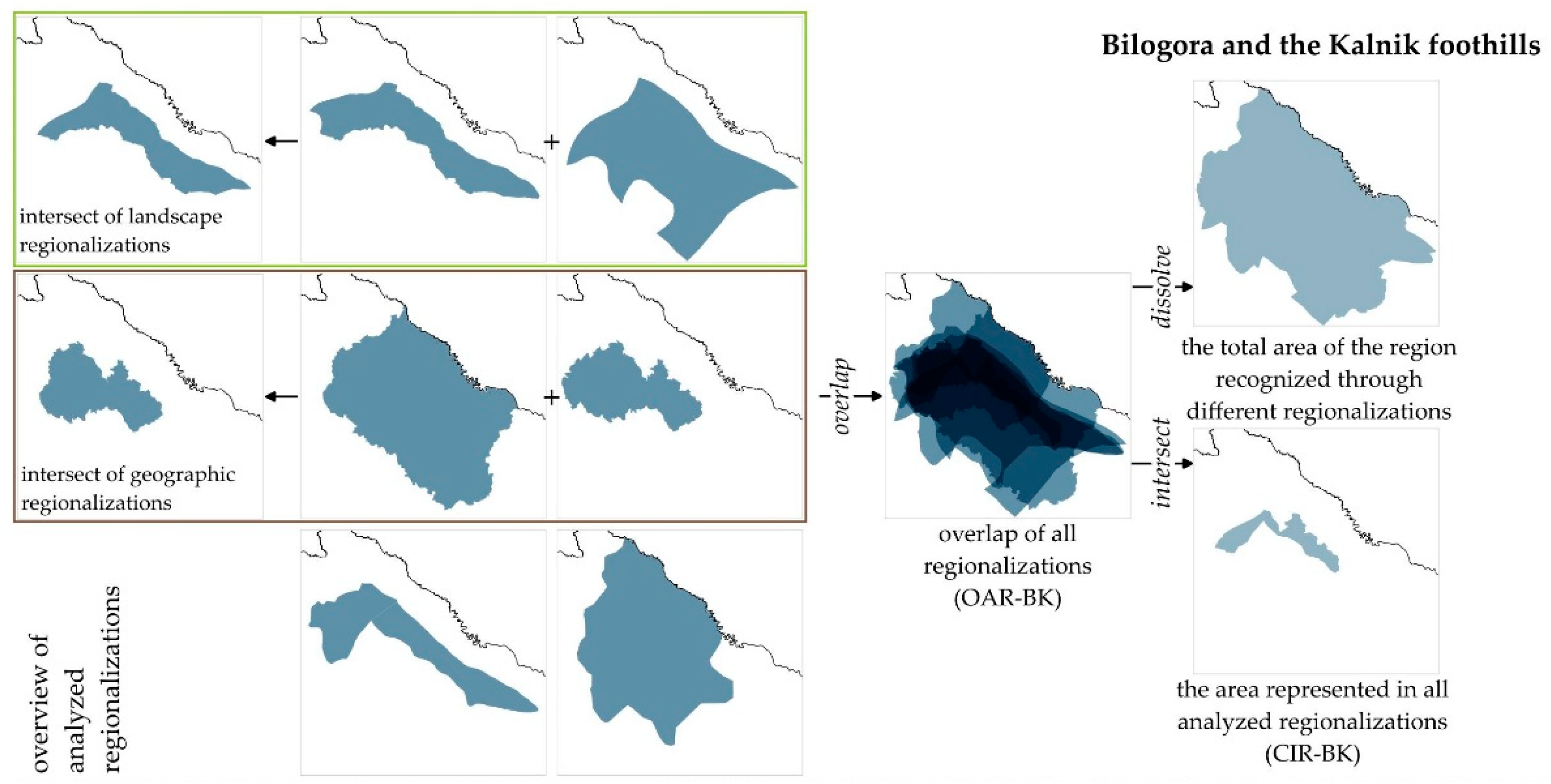
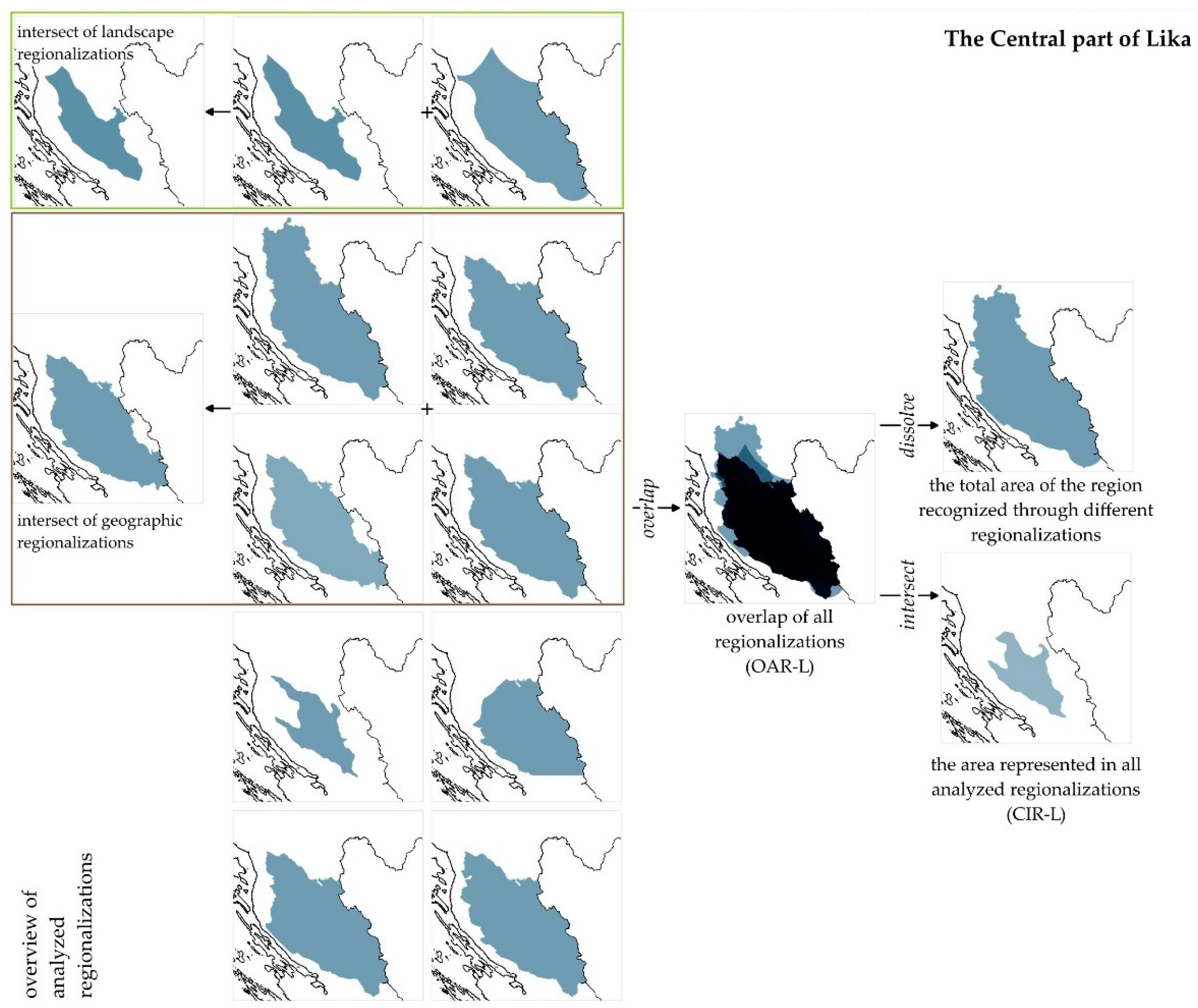
The next step in the research was an overlap with the aim of determining differences in approaches to locating regional boundaries and identifying key features. The overlap between the two resulted in establishing (1) the area represented in all analyzed regionalizations for a particular region (using the Intersection function in QGIS), (2) the total area of the region recognized through different regionalizations (using the Dissolve function in QGIS), with particular emphasis on (3) the overlap of existing landscape regionalizations and (4) geographic regionalizations (both using the Intersection function in QGIS) (Figure 2 and Figure 3). Based on the calculated areas of each observed region (Appendix A, Table A1), the overlap shares were obtained, allowing for the determination of similarities and differences between the approaches, and the identification of key landscape features, i.e., elements that convey the identity of landscape regions.

3. Results

An overview of the existing regionalizations was divided into the following three groups: (1) landscape regionalizations, (2) geographic regionalizations (as a combination of natural and anthropogenic factors, viewed by different experts), and (3) natural and cultural regionalizations (Appendix A, Table A1).

3.1. Bilogora and the Kalnik Foothills

3.1.1. Landscape Regionalizations of Bilogora and the Kalnik Foothills

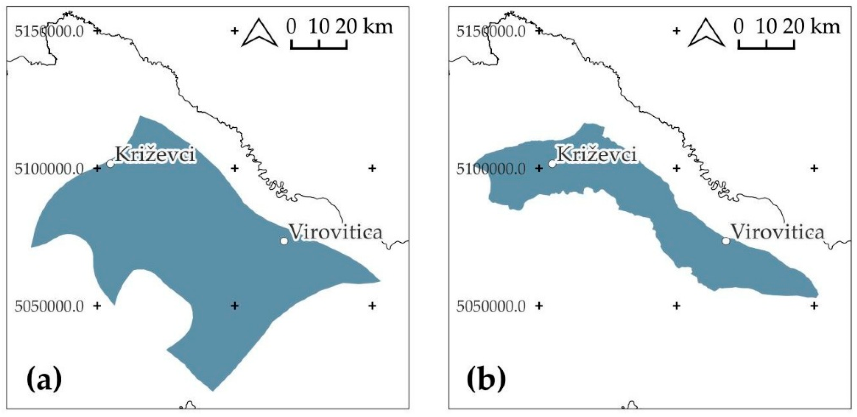
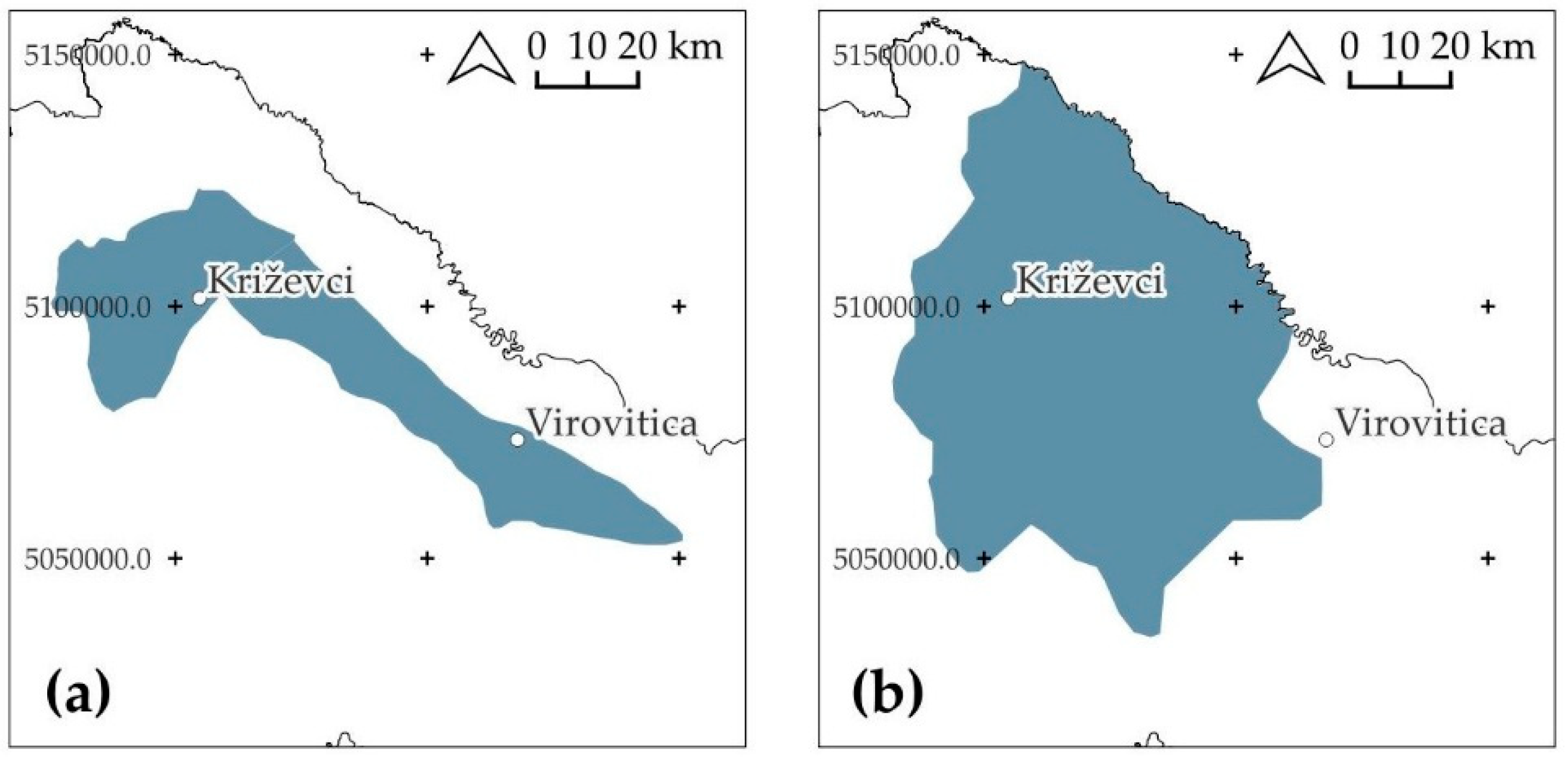
The first landscape regionalization [49] considers the Bilogora-Moslavina area as a whole (Figure 4a), that is, the Bilogora area, bordered by Medvednica, Moslavačka gora (not part of the region, although the “Moslavina area” is included in the name), the Slavonian highlands (Papuk, Psunj, and Ravna Gora), and the large river valleys of the Drava (Podravina) and Sava (Posavina). The region includes several larger settlements, namely cities such as Križevci, Bjelovar, Virovitica, etc. In contrast, the 2024 LCA of the Republic of Croatia considers “Bilogora and the Kalnik foothills” (Figure 4b), as a whole, an area half the total size, namely Bilogora together with the structurally similar area of the Kalnik foothills that extends west, and of the larger settlements, it includes only Križevci.

3.1.2. Geographical Regionalizations of Bilogora and the Kalnik Foothills

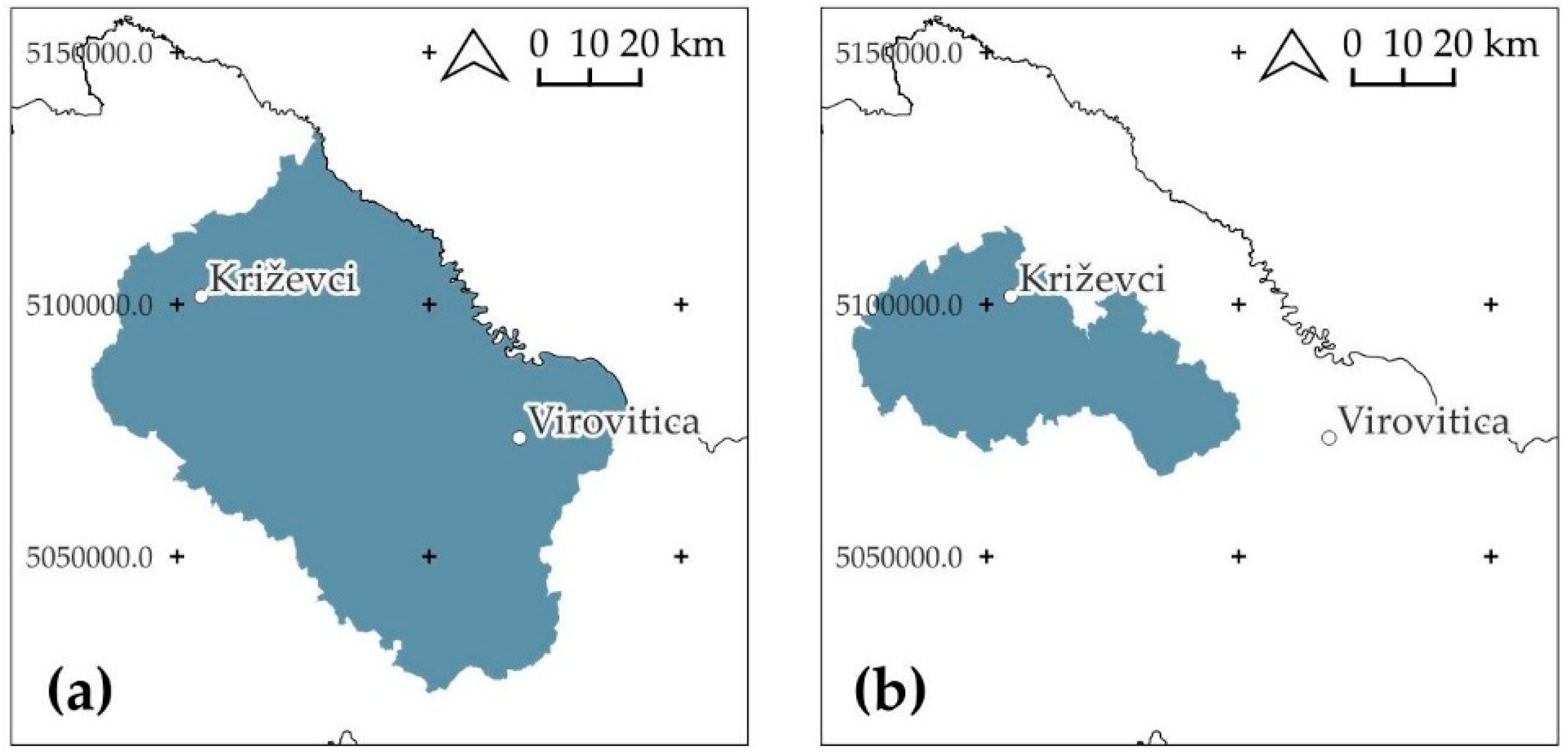
For the analysis of geographic regionalizations for the Bilogora area, only the following two regionalizations were taken that correspond to the given selection criteria for the analysis: (1) the regionalization of Croatia [53], which as a whole defines the region “Lonja-Ilova valley and the Bilogora part of Podravina” (Figure 5a) and (2) the conditionally homogeneous regionalization [54], which at the third spatial level defines the whole “Kalnik-Bilogora foothills area” (Figure 5b).
The natural–geographic regionalization [52] was excluded from the analysis because it was developed at two spatial levels, and the subject area at the second level remained within “the Valley of Northwestern Croatia”, which is a large area covering the territory from the border with the Republic of Hungary to the border with Bosnia and Herzegovina and does not meet the given selection criteria. In addition, the conditionally homogeneous regionalization [55] was also excluded because it was developed at four spatial levels, but not all spatial units of the third level were additionally divided. Therefore, the second level was considered relevant, where the subject area is located on the border of the following three regions: (1) the Western and (2) the Eastern Peripannonian area and (3) the East Croatian Plain, and it does not meet the given selection criteria for the analysis procedure.
The regionalization from 1974 [53] covers a large area (628,085.76 ha) bordered by the river Drava in the north, Međimurje and Kalnik in the northwest, Posavina and Moslavačka gora in the south, and Slavonian highlands in the east. It includes several larger cities, such as Križevci, Virovitica, Bjelovar, etc. On the other hand, the “Kalnik-Bilogora foothills area” from the conditionally homogeneous regionalization from 1983 [54] includes only Križevci and Bjelovar of the larger settlements; it excludes the Podravina, Moslavina, and Slavonia parts of the region; it also excludes the peak parts of Bilogora, the Kalnik and Bilogora foothills, and it includes large river plains at the base of the foothills.

3.1.3. Natural and Cultural Regionalizations of Bilogora and the Kalnik Foothills

Geomorphological regionalization [56] takes relief and hydrological characteristics of the area as the main criteria, and the subject area is observed through two regions at the third spatial level: (1) “Bilogora hills with Slatinsko-voćinski hills” and (2) “Kalnik mountain massif with foothill step and Žitomir hills” (Figure 6a). Of the larger settlements, it includes Križevci and Virovitica.
Among the cultural regionalizations, only the agricultural regionalization from 1993 was considered for the subject area. According to the characteristics of traditional architecture, the subject area is located on the border of Slavonia and Srijem, Podravina, and Hrvatsko Zagorje. Proleksis [65] defines it only as a relief elevation and does not recognize it as a separate Croatian region. The agricultural regionalization [57] recognizes the broader subject area as the “Bilogora-Moslavina-Podravina region” (Figure 6b) and encompasses the area from the border with the Republic of Hungary to Posavina and the Slavonian highlands, bordered to the west by Medvednica.

3.2. The Central Part of Lika

3.2.1. Landscape Regionalizations of the Central Part of Lika

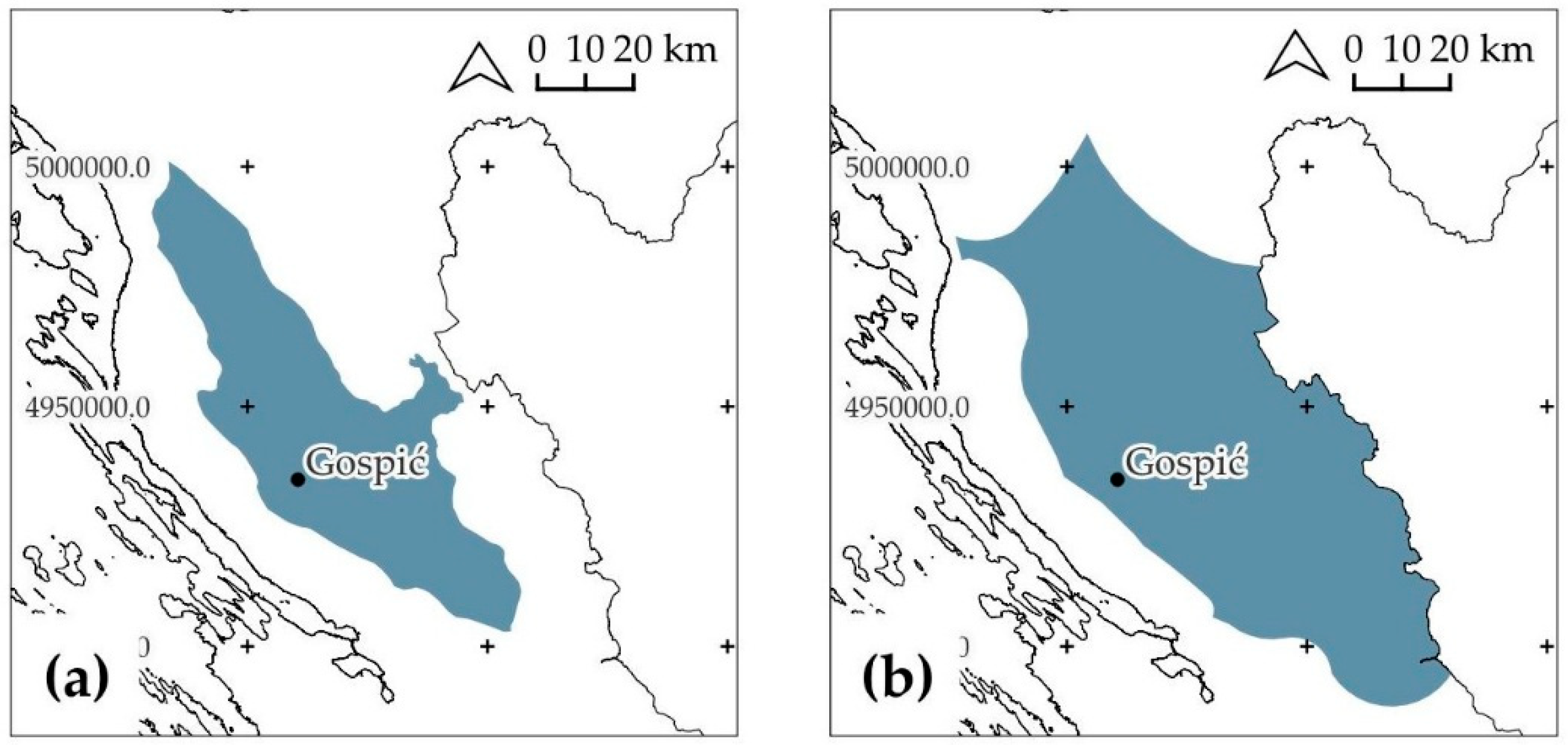
In the 2024 LCA of the Republic of Croatia, the area in question was recognized as “The Central part of Lika” (Figure 7a) and, in 1995, as “Lika” (Figure 7b). Both regionalizations attribute to Lika the area east of Velebit, from the hinterland of Senj to Gračac, the settlements of Otočac, and Gospić, while in the 1995 regionalization, Josipdol and Donji Lapac are also included.

3.2.2. Geographical Regionalizations of the Central Part of Lika

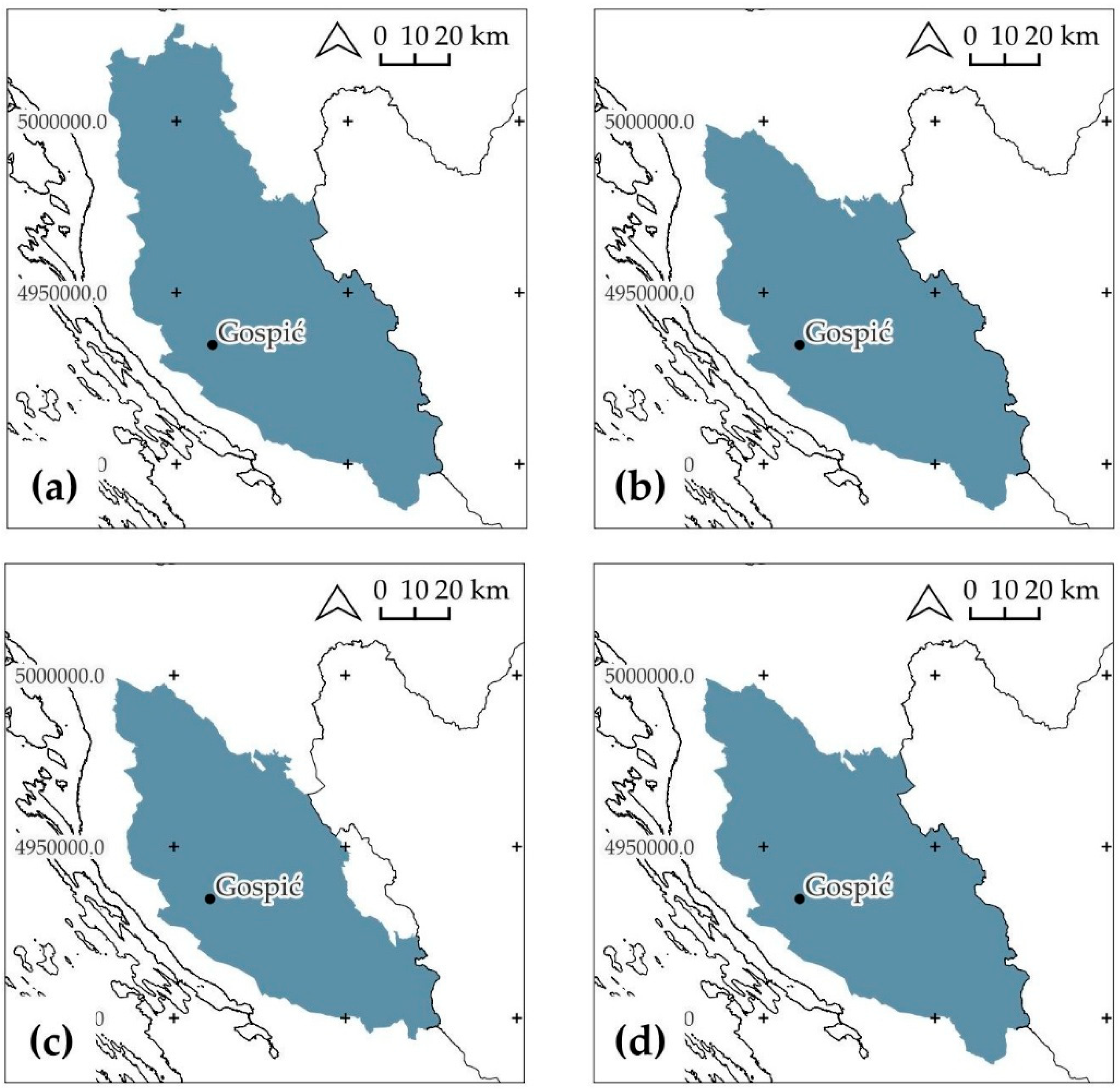
For the analysis of geographic regionalizations for the Lika region, the following four regionalizations were taken that correspond to the given selection criteria for the analysis: (1) natural–geographic regionalization [52] (“Lika”; covering the area from Ogulin to the wider area around the source of the Zrmanja River; bordering Velebit to the west and the border with Bosnia and Herzegovina to the east) (Figure 8a); (2) regionalization of Croatia [53] (Figure 8b) and (3) conditionally homogeneous regionalization [55] (“Lika”; identical coverage from Mala Kapela to the wider area around the source of the Zrmanja River) (Figure 8d); and (4) conditionally homogeneous regionalization [54] (equal to the previously mentioned, but without parts of the border areas and the wider area around the source of the Zrmanja River) (Figure 8c).

3.2.3. Natural and Cultural Regionalizations of the Central Part of Lika

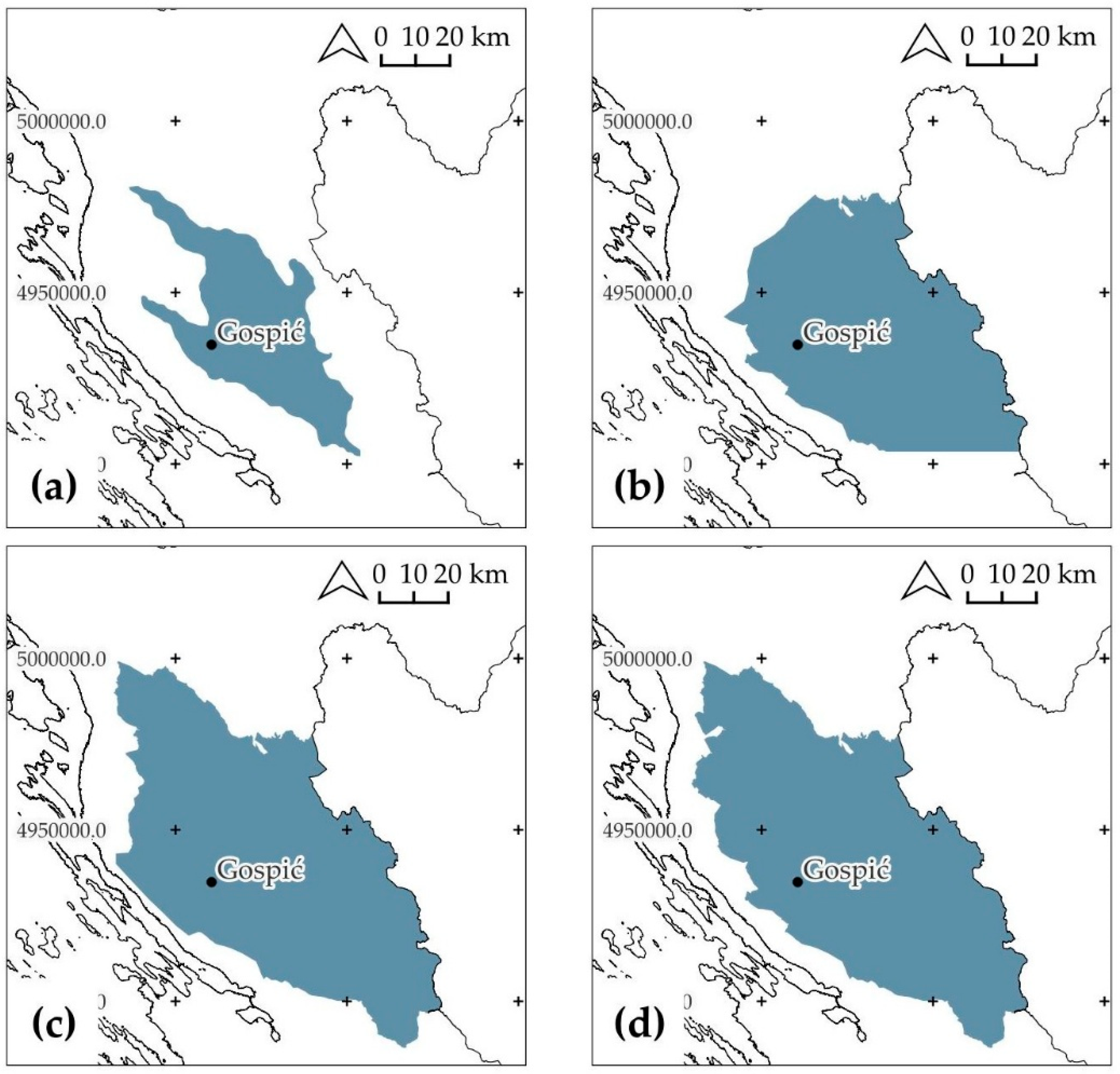
Geomorphological regionalization [56] calls the area in question the “Lika Valley” (Figure 9a), and it encompasses the areas of Gacka (Otočac), Lika (Gospić), and Gračac field (Gračac), along with the surrounding hills.
Of the cultural regionalizations, the analysis includes (1) the agricultural regionalization [57] (Figure 9b), (2) the regionalization of traditional architecture [58] (Figure 9c), and (3) the historical–geographic regionalization according to the Proleksis encyclopedia [59] (Figure 9d). The agricultural regionalization [58] covers the territory from the surrounding area of Brinje to the source of the Zrmanja River, enters the central part of Velebit in the west, and extends all the way to the border with Bosnia and Herzegovina. Within the framework of traditional architecture, Živković [58] defines Lika as an area of wooded karst with coniferous forests and, in some areas, mixed species. In the narrow strip of the Velebit coast, there is pure karst. Lika was then a border area (towards Turkey), and this meant an unsafe area, which was not conducive to greater settlement, and especially not to the formation of larger rural settlements. Since Lika, although located in a small area, still has somewhat different natural conditions (rich in coniferous forests in the northern part, with more stone and mixed forest species in the south), this was also reflected in architecture. Proleksis [59] defines Lika as a “historical and geographic region” in Croatia, between Velebit in the west and Plješevica and the Kapela massif in the east. Territorially, it is part of the Lika-Senj County (the cities of Gospić and Otočac; the municipalities of Brinje, Donji Lapac, Lovinac, Perušić, Plitvička jezera, Udbina, Vrhovine) and Zadar County (the municipality of Gračac). Within the mountain system, there is a vast valley with numerous karst fields, which are the Lika, Gacka, Krbava, Korenica, and Lapac fields.

3.3. Comparison of Results in Two Regions

Every landscape has its own identity, which is based on (1) its physical characteristics, (2) the processes that take place in the landscape, and (3) the meanings that people attach to it [3,66]. It is both material reality and a perceived, mental construction [11,18]. Identity comes about through distinguishing one thing from another, that which we exclude becomes part of identifying [46,67], exposing both ”sameness” and ”distinctiveness” simultaneously [46,68,69]. By comparing the research results, certain similarities and differences were observed between the approaches of individual regionalizations, but also between the approaches to two geographically distinct regions in Croatia.

3.3.1. Bilogora and the Kalnik Foothills Regionalization Comparison

By comparing the landscape regions in the Bilogora area, different approaches to this space come to the forefront. Bralić [49] recognized the area between Podravina and Posavina, i.e., Slavonia and the mountains of northwestern Croatia as a whole. The 2024 LCA of the Republic of Croatia took a similar approach, but with the separation of Bilogora and the Kalnik foothills from the small river plains at the base of the hills, the joining of the Kalnik foothills to Bilogora, and not to the Kalnik ridge, and with a more precise delineation of the boundaries of the landscape regions, especially towards Moslavačka gora and Slavonian highlands. On the other hand, the two analyzed geographic regionalizations almost completely coincide; the “Kalnik-Bilogora foothills area” from the conditionally homogeneous regionalization from 1983 makes up 32% of the area of the previously mentioned region from 1974, but the regionalization from 1974 considers a significantly wider area because it takes the Lonjsko-Ilovska valley and the Bilogora part of Podravina as a whole. It should also be considered that the regionalization from 1974 was analyzed at the second spatial level (due to data availability) (Appendix, Table A1) and that from 1983 at the third level, thus representing more precise data. The aforementioned inability to include the second spatial level of conditionally homogeneous regionalization in the analysis (given that according to it the area in question is located on the border of three regions) represents a disadvantage when comparing data. Furthermore, it was observed that the extent of the analyzed geomorphological region in the Bilogora area follows the shape of the 2024 landscape region. However, the borders appear more generalized, reflecting the influence of scale; at broader scales, smaller details are omitted, resulting in simpler, smoother boundaries.
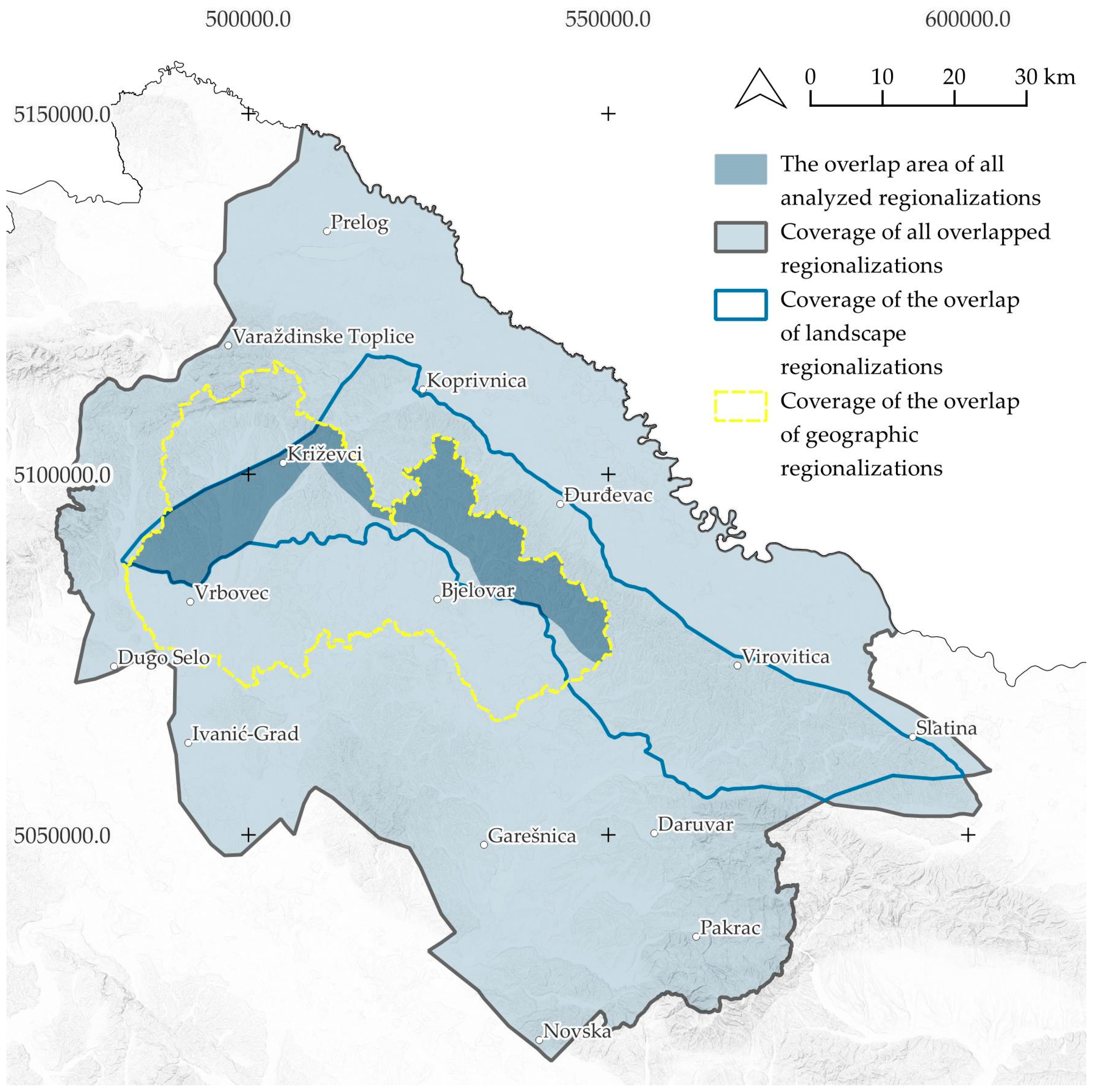
By overlapping and dissolving all regionalizations that meet the required criteria, i.e., that the region contains “Bilogora” and preferably “Kalnik” in its name, an area with a total area of 836,353.50 ha was obtained. It extends from the city of Čakovec along the Drava River to the Slavonian highlands, west of Medvednica, along the northeastern edge of Posavina (Figure 10). Within the specified area, there is a very small part of the area where all the analyzed regionalizations coincide (CIR-BK), which is only 52,975.57 ha, or 6.33%. For comparison, the latter makes up 23.03% of the area of the landscape region from 2024. The area around which all the analyzed regionalizations agree that it belongs to Bilogora includes part of the southeastern slopes of the Kalnik foothills and part of the southwestern slopes of Bilogora, while of the larger settlements it includes only the city of Križevci.
Despite the fact that both landscape and geographic regionalizations consider both natural and anthropogenic (cultural–historical, social, economic) characteristics of the landscape, a significant difference is visible between them. They overlap on an area of 70,107.73 ha, or 37% of the area covered by the overlapped landscape regionalizations (OLR-BK), and 40% of the area covered by the overlapped geographic regionalizations (OGR-BK). Although similar in proportion, they are very different in scope; the overlap of landscape regionalizations (OLR-BK) excludes the river plains at the base of Kalnik and Bilogora, as well as higher parts of Kalnik, while the overlap of geographic regionalizations (OGR-BK) does not consider the northern slopes of Bilogora, nor in general the entire eastern part of Bilogora south of Virovitica.

3.3.2. The Central Part of Lika Regionalization Comparison

In the Lika region, a similar approach to drawing boundaries of landscape regions is visible, with several significant deviations. Bralić [49] (1995) includes the areas of the Mala Kapela and Lička Plješivica in Lika (the eastern border of the region is also the border with Bosnia and Herzegovina). The LCA from 2024 also includes the part north of the settlement of Brinje. Due to the above, the area of the 1995 region is twice as large (524,835.82 ha) as the region from 2024 (261,043.12 ha); that is, the area of their overlap (OLR-L) makes up 92.45% of the total area of the region from 2024. This leads to the conclusion that the previously developed regionalization (the one from 1995) has a broader understanding of the landscape region, but there is agreement on key characteristics.
All authors of geographic regionalizations call this area “Lika”, except for Roglić, who calls it “The Lika Valley” (the only regionalization analyzed at the third spatial level; at the second level it is part of “Mountainous Croatia”). Cvitanović [53] (1974) and Magaš [55] (2013) define the area with an identical scope, and both completely coincide with Bognar’s regionalization, in which the northern part was added. In Roglić’s regionalization from 1983, in comparison with the ones from 1974 [53] and 2013 [55], the eastern part and the extreme southern part were excluded. The geomorphological regionalization [56], as well as the geographic regionalization from 1983 [54], calls the area in question “The Lika Valley” but defines a 60% smaller area. Viewed as a whole, the coverage follows the form of the landscape region from 2024 [50], excluding the wider surroundings of Brinje, and they overlap in 63.62% of the area. It is important to note that all geographic regionalizations used in the development of the LCA of the Republic of Croatia in 2024 [50] were reduced to the modern administrative–territorial organization of the Republic of Croatia, because many of them were created before the 1990s, when the aforementioned organization did not exist. This also affected the coincidence of their borders.
All three cultural regionalizations refer to the region in question as “Lika” and are very similar in scope and area. The historical–geographic and agricultural regionalizations differ only (1) in the northwest, where the historical–geographic one extends towards Senj, and (2) in the west, where the agricultural region extends towards the central part of Velebit. The regionalization of Croatian traditional architecture in relation to the historical–geographic regionalization eliminates the wider area of Otočac and south of Gračac.
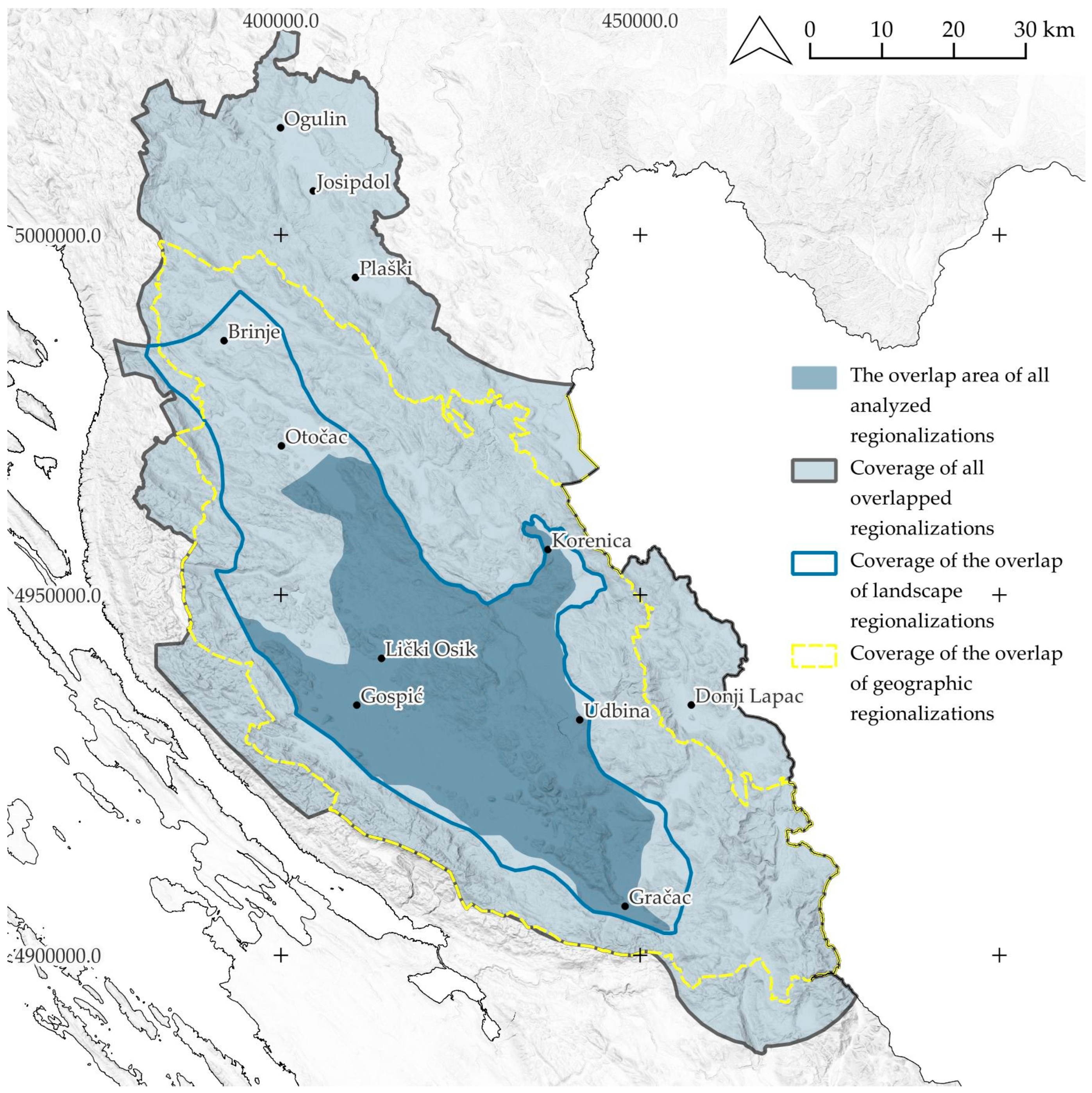
By overlapping and dissolving all regionalizations (OAR-L) that meet the required criterion, i.e., that the region contains “Lika” in its name, a scope with a total area of 688,075.05 ha was obtained. It extends from Ogulin to the northern part of the surroundings of the city of Knin, i.e., from Gorski Kotar to the border with Bosnia and Herzegovina and partly includes the Velebit massif (Figure 11). Within the specified scope, only a fifth (22.14%) of the area of all analyzed regionalizations coincides (CIR-L). Despite this, the latter makes up 58.35% of the area of the landscape region from 2024. The scope around which all analyzed regionalizations agree that it belongs to Lika includes the area of the southern part of the Gacka field, Lika field (Gospić), and Gračac field (Gračac).
Unlike the large discrepancies in Bilogora, there is a large concurrence of the overlapped data of geographic and landscape regionalizations in Lika. They overlap over an area of 238,979.17 ha, or 99% of the area covered by the overlapped landscape regionalizations (OLR-L), and 50.54% of the area covered by the overlapped geographic regionalizations (OGR-L), which indicates that the geographic regionalizations include a wider area for Lika.

4. Discussion

4.1. Identity of the Regions

Perko et al. [70] stated that landscape classification plays an important role in the preservation of natural and cultural landscapes; therefore, it is important to preserve the part of the landscape unit that everyone agrees bears the identity of the region in question.
In the Bilogora area, there are relatively large variations in the understanding of the identity of the region, especially when comparing the overlap (intersection) of geographic (OGR-BK) and landscape regionalizations (OLR-BK). Landscape regionalizations as a whole consider Bilogora in its entire length (from Kalnik to the foothills of Papuk) and most of the Kalnik foothills. The overlap of geographic regions takes, as a whole, the foothills up to the ridges of Kalnik and Bilogora in the hinterland of Križevci and Bjelovar, and the river plain at their foothills.
When investigating the basic characteristics of the core of a landscape region, of the total area of the geomorphological region, 22.42% is part of the area where all regionalizations overlap, which is an area that carries the identity of the region (CIR-BK). The aforementioned regionalization takes as its criteria the relief and hydrological characteristics of the area, which are also listed in the LCA of the Republic of Croatia as criteria for drawing landscape regions. As for the agricultural region, 9.34% is part of the area where all regionalizations overlap (CIR-BK). Given that this is the only cultural region that somehow recognizes Bilogora, it is concluded that the area in question is not recognized in that sense, and it is not possible to confirm the validity of the criteria for drawing a landscape region listed in the LCA of the Republic of Croatia. This highlights that the methodology can be adapted to account for the specific characteristics of each area while still revealing general patterns applicable across all case studies.
The possibility of adapting the approach to the overlapping process arises by excluding the conditionally homogeneous regionalization from 1983 (which results in a more comprehensive understanding of Bilogora). With the additional exclusion of the regionalization according to Bralić [49], which excludes the Kalnik foothills, a relative overlap of the geomorphological and the LCA from 2024 is visible, supported by the wider spatial scope of the geographic regionalization from 1974 and the agricultural regionalization from 1993.
Thus, as an area that bears the identity of the Bilogora region (CIR-BK), a very small area of the Bilogora and the Kalnik foothills was obtained; part of the Kalnik hills and half of Bilogora were excluded. For comparison, the Croatian Encyclopedia [71] defines Bilogora as “a series of hills that stretch from the northwest to the southeast between Podravina and the Lonjsko-Ilovska valley, for a length of approximately 80 km. In the west it is connected to Kalnik, and in the east to Papuk. Along the northeastern foothills of Bilogora are the larger settlements of Koprivnica, Đurđevac, Pitomača and Virovitica, and along the southwestern Križevci, Bjelovar and Grubišno Polje”. By overlapping all regionalizations, an area was obtained that eliminates the higher parts of the slopes of the Kalnik, the northern slopes of Bilogora towards Podravina, and the entire eastern part of the Bilogora hill itself (OAR-BK).
By analyzing the basic characteristics of the core of Lika of the total area of the geomorphological region of the Lika Valley, it was found that 81.14% is part of the area where all regionalizations overlap (CIR-L). Furthermore, in relation to the landscape regionalization from 1995 and geographic regionalizations, the LCA of the Republic of Croatia defines this region as the “The Central part of Lika”, and Velebit, Mala and Velika Kapela, and Lička Plješivica as separate regions. With this in mind, it can be said that the overlaps of landscape and geographic regionalizations coincide in the area of Lika. In addition, the landscape region “The Central part of Lika” almost completely (98.65%) fits into the scope of the historical–geographic region according to Proleksis [59] and agricultural regionalization [57], but it also fits into the region of traditional architecture (76.18%), which confirms that cultural regions are one of the criterion for drawing the boundaries of landscape regions. This is in accordance with recent research, which emphasizes the importance of integrating spatial information of the natural landscape features with their historical, social, and cultural dimensions [29]. Additionally, unlike Bilogora, Lika is recognized as a cultural region at the level of the Republic of Croatia.
As with Bilogora, by excluding some regionalizations, it is possible to obtain different and more precise research results. By excluding the natural–geographic regionalization (1996) and landscape regionalization according to Bralić [49], the area north of Brinje, i.e., part of Velika Kapela and Ogulin-Plaški valley, which are part of Lika only on the basis of the aforementioned regionalizations, is eliminated from the total overlapped area.
Therefore, the area determined to possess the identity of the landscape in the Lika region, i.e., the area obtained by overlapping different regions, does not include Plitvice Lakes, Velebit, Mala and Velika Kapela, Lička Plješivica, the northern part of Gacka, and Lika fields, which the Proleksis [59] recognizes and lists as part of Lika. Nevertheless, the above can be justified in this case by the fact that the LCA from 2024 only observed the central part of Lika and not the whole of Lika.

4.2. Determination of the Criteria

Furthermore, the above research results were compared with the criteria for distinguishing landscape units at the regional level, which are listed in the LCA of the Republic of Croatia from 2024 (Table 1). According to the identified key characteristics obtained by overlapping in both subject areas, it is possible to determine that the adequate criteria for distinguishing landscape regions are (1) hydrology and (2) relief. This is evident from the coincidence of the geomorphological regions from 1999, with parts of the region common to all overlapped regionalizations (CIR, whose main criteria for distinguishing are precisely hydrology and relief). As for the hydrological network at the regional level, it represents a dominant natural feature of the landscape. Large and small rivers form valleys and river plains whose boundaries in space are very easy to determine; likewise, the density of the hydrological network (streams) on the slopes of the hills represents an important feature of the landscape of some regions, specifically in this case in the Bilogora area. In Lika, water bodies are a fundamental feature of large karst fields subject to periodic flooding in relation to the surrounding area of hills and mountains under forests characterized by water scarcity. Furthermore, geomorphological regionalization, as well as the LCA from 2024, separates large (dominant) relief elevations from lowlands, plateaus, and valleys; in the case of Bilogora and Kalnik, it separates them from the mountain ranges of the Hrvatsko Zagorje and the Slavonian highlands, also the Drava River valley, and the smaller river valleys of the Lonja, Česma, and Ilova rivers, and in Lika, it separates the mountains (Velebit, Lička Plješivica, Mala, and Velika Kapela) from the central part, in which there is an alternation of lower hills and vast karst fields.
Unlike the criteria that consider natural features, there are conflicting views regarding anthropogenic features, i.e., cultural regions. It is not possible to establish agreement with this criterion for Bilogora because, in this sense, it is associated either with Podravina or Moslavina, and less often with Slavonia or Hrvatsko Zagorje. In contrast, Lika is recognized as a cultural region, but in this sense, it is perceived more broadly than shown through natural features or the LCA from 2024 [50].

4.3. Possibilities for Improving the Approach to Landscape Regionalizations

For typologies to gain general acceptance, for landscape units, as well as for all other properties that can be generalized into types, it is critical that they are developed by use of explicitly stated rules by repeatable procedures [2,5]. The multidimensional structure of the physical landscape makes all approaches involving classification artificial because they involve drawing boundaries in a basically continuous environment, and this is proof that no single correct characterization method exists [2]. As stated in Atik and Karadeniz [28], regional heterogeneity and the high local diversity of landscapes seem to be difficult to fit into a single trait. Additionally, dualities such as objective and subjective, quantitative and qualitative, and local and regional features can be involved in the modification of LCA [28]. It may be that this geographical and organizational diversity is a significant factor behind the lack of direct expression of characterization in regional and district policy. While many characterization and assessment studies have been commissioned as part of plan-making processes, it is unusual for character units (however defined) to be expressed formally as the basis for areal planning policy. In most cases, the characterization forms part of the background material upon which policy is developed [72].
It is therefore important to consider the difference between the overlap area of all the analyzed regionalizations in both subject areas (CIR, what is determined by the overlap to bear the key characteristics of the region) and what is perceived as a region in that area. As stated by Ipsen [73], landscape as a term implies its dual character: (1) a material objective structure in space, and (2) a subjective, culturally determined form of perception and evaluation of that same material structure. Furthermore, the European Landscape Convention defines landscape as “an area, perceived by people, the character of which is the result of the interaction of natural and/or human factors” and thus places emphasis on the human experience of landscape, highlighting the issue of perception and character of landscape [74]. Although both the European Landscape Convention and planning rhetoric recognize people–environment relationships, issues of identity are rarely addressed in practice [46,75,76]. Defining these identities helps policy makers and communities to think spatially about their region (through maps) and to shape the future direction, because it serves as a catalyst for economic growth, cultural preservation, and social cohesion, fostering a deep sense of belonging and affection among residents and contributing to the development and resilience of the region [38,77,78]. At the core of the European Landscape Convention is the identification and assessment of landscapes everywhere, in natural, rural, urban, and peri-urban areas. The Convention dictates that signatories of the Convention must identify their own landscapes throughout its territory and to analyze their characteristics and the forces and pressures transforming them [28].
Public participation can thus become an integral part of distinguishing the identity of a landscape because there is a difference between the physical description of a landscape and the social perception of a landscape. Olwig [79] states that a landscape is not just a space and is not an objective thing; it is an expression of the perception of a space that people share, value, and use. Because it has always been in constant flux, it has been constantly contested and reworked in relation to individual experiences, social understanding, and political circumstances [46]. Even if the physicality does not change, how individuals and communities perceive the landscape will change over time, through altered cultural appreciation [46,73,80]. In contemporary landscape research, fuzzy logic has become an important tool, primarily used in landscape modeling, multi-criteria analysis (MCA), and other spatial assessment methods [81,82]. It is often applied at finer, local scales to capture detailed spatial variations, and it was not applied in this research. On the other hand, Bartůněk and Bláha explored approaches that adopt a fluid (fuzzy) approach to regional boundaries, i.e., “fluid regionalisation” [38,83]. It encapsulates this approach to regionalization, demonstrates its application beyond traditional regional geography [38,84], and seeks to reveal the multiple layers of various individual regions in the cultural landscapes they encompass [38,85]. In landscape studies, we find mainly strict borderlines that are abstractions, while in reality, only transition zones exist. This is a challenging issue for digital mapping that has to be solved in the future, because concrete local knowledge completes the integrative, rational professional view [11].
The main contribution of this research is the first comprehensive overview of regionalizations developed to date for the territory of the Republic of Croatia, as well as their comparison in two geographically distinct areas. By encompassing different types of regionalization, it also promotes the view of landscape studies (LCA) as an integrating force that encourages joined-up thinking, that can bring people together in discussion, and that offers a tool usable for bigger challenges [86]. Furthermore, the holistic framing of landscape and landscape change enables characterization to become a potentially powerful tool in the shaping of development proposals. In this way, landscape assessment can evolve as an agent of managed change, rather than a preservation tool, ensuring its continuing relevance [72]. In addition to the national level, this creates a foundation for the further development of landscape studies at sub-regional and local levels, all aimed at integral spatial analysis and management. This is particularly relevant in Croatia, where landscape studies are still in their early stages, making it necessary to establish clear starting points for a unified approach in future research.
Apart from the lack of human perception in the analyzed regionalizations, the main shortcomings of this research, as well as research related to regionalizations in Croatia, are as follows: (1) the absence of developed regionalizations for all criteria important for the delineation of landscape units at the regional level; (2) the obsolescence of the developed regionalizations (except for the LCA from 2024 and the conditionally homogeneous regionalization from 2013, all others were developed in the 20th century); and (3) differing regionalization criteria, which affects the precision and quality of data comparison. Regarding the obsolescence of the developed regionalizations, certain older findings are considered very important because they provide an extensive overview of publications on different regionalizations over a period of 50 years (1974–2024). During this period, people’s attitudes towards nature and landscape changed significantly, and a comparison of the typification methods used in the examples presented shows gradual changes or development of methods over the past few decades [33]. Additionally, for the purposes of this research, the boundaries of these regionalizations have been subsequently adjusted and aligned with the current administrative–territorial division of Croatia. Any outdated data or criteria from the original sources were carefully considered, and the regional boundaries were corrected to reflect contemporary conditions, minimizing potential inaccuracies due to temporal changes or older methodologies.
The above-mentioned point opens up the possibility of further research into the understanding of the regions in question, particularly in the context of vernacular regions, which can be determined by examining the attitudes of the general public and comparing the results of both surveys. It also allows for the identification of these regions using three main factors, which are physical, perceptual, and meaning [72]. This is important because, although institutionalized regions may theoretically align with people’s regional consciousness, they may still not appear in the cognitive map [38,87].

5. Conclusions

By reviewing the different regionalizations of the Republic of Croatia, with an emphasis on the areas of Lika, Bilogora, and Kalnik, numerous similarities and differences between the approaches to creating regionalizations were identified, as well as specificities in the approach to each individual area.
The overlapping procedure resulted in parts of the regions common to all analyzed regionalizations, or areas that possess key landscape characteristics (landscape identity). In the case of “Bilogora and Kalnik foothills”, this includes part of the southeastern slopes of the Kalnik foothills (the city of Križevci) and part of the southwestern slopes of Bilogora. In the case of “The Central part of Lika”, this refers to the area from the southern part of Gacka field, Lika field (Gospić), and Gračac field (Gračac).
Establishing the identity of Lika, both in a broader and narrower sense, was a simpler process than with the Bilogora and Kalnik foothills, because Lika is recognized as a cultural region at the level of the Republic of Croatia. Its name is almost always present in regionalizations by various authors, which increases the possibilities for researching its extent and borders. In contrast, the key characteristic of Bilogora among the wider population is its perception as a hill, rather than as an independent region. For this reason, as a cultural region, it is most often considered part of Podravina and Moslavina and less often of Hrvatsko Zagorje and the western part of Slavonia.
Furthermore, it can be concluded that, among the different regionalizations, there is greater agreement regarding criteria related to natural features (specifically, relief and hydrological features), while the situation regarding anthropogenic features (cultural regionalizations) is much more complex, as human perception, which is influenced by numerous and diverse factors, is an integral part. As recognized by the Convention [51], the landscape is “an expression of the diversity of shared cultural and natural heritage”. Accordingly, the parts common to all layers, obtained by the pure overlap of regions, differ from the general perception of a particular region as such.
Based on this research, it was determined that the contemporary identity of the landscape is subject to constant re-examination, given new scientific knowledge and ongoing changes in the way individuals perceive the landscape. Furthermore, when determining the boundaries of landscape units (regions), it is important to consider all available data and the criteria used for their creation, as well as to involve the concerned general public in their selection. These findings have practical implications for spatial and landscape planning, providing guidance for the development of management tools and strategies that reflect both scientific understanding and societal values.

Author Contributions

Conceptualization, L.B. and D.T.R.; methodology, L.B. and D.T.R.; software, L.B.; formal analysis, L.B.; investigation, L.B. and D.T.R.; resources, L.B. and D.T.R.; data curation, I.H. and M.K.; writing—original draft preparation, L.B. and D.T.R.; writing—review and editing, M.K., I.H., and P.P.; visualization, L.B.; supervision, P.P. All authors have read and agreed to the published version of the manuscript.

Funding

This research received no external funding.

Data Availability Statement

The original contributions presented in the study are included in the article, further inquiries can be directed to the corresponding authors.

Conflicts of Interest

The authors declare no conflicts of interest.

Abbreviations

The following abbreviations are used in this manuscript:
LCALandscape Character Assessment
OLR-BKOverlap (intersect) of landscape regionalizations (Bilogora and the Kalnik foothills)
OGR-BKOverlap (intersect) of geographic regionalizations (Bilogora and the Kalnik foothills)
OAR-BKOverlap (dissolve) of all regionalizations (Bilogora and the Kalnik foothills)
CIR-BKAn area that carries the identity of the region (Bilogora and the Kalnik foothills)
OLR-LOverlap (intersect) of landscape regionalizations (The Central Part of Lika)
OGR-LOverlap (intersect) of geographic regionalizations (The Central Part of Lika)
OAR-LOverlap (dissolve) of all regionalizations (The Central Part of Lika)
CIR-LAn area that carries the identity of the region (The Central Part of Lika)

Appendix A

Table A1. Overview of analyzed regionalizations.
Title of the Region
(Subject Region: 1-Bilogora/Kalnik, 2-Lika)
Area (ha)
Landscape regionalizations
Landscape regionalization, 1995.1: Bilogora–Moslavina area494,301.36
2: Lika524,835.82
LCA of the Republic of Croatia, 2024.1: Bilogora and Kalnik foothills229,985.39
2: The central part of Lika261,043.12
Intersection of landscape regionalizations of Bilogora/Kalnik189,521.72
Intersection of landscape regionalizations of Lika241,296.05
Geographical regionalizations
Natural–geographical regionalization, 1996.1: N/AN/A
2: Lika636,958.27
Geographic regionalization, 1974.1: Lonjsko-Ilovska valley and the Bilogora part of Podravina628,085.76
2: Lika527,920.89
Conditionally homogeneous regionalization, 1983.1: Kalnik–Bilogora foothills area202,108.75
2: Lika valley472,832.72
Conditionally homogeneous regionalization, 2013.1: N/AN/A
2: Lika527,920.89
Intersection of geographical regionalizations of Bilogora/Kalnik175,527.11
Intersection of geographical regionalizations of Lika472,832.72
Natural regionalization
Geomorphological regionalization of Croatia, 1999.1: Bilogora hills with Slatinsko-voćinski hills / Kalnik mountain massif with foothill step and Žitomir hills236,250.90
2: Lika valley187,731.68
Cultural regionalizations
Regionalization of Croatian traditional architecture, 2013.1: N/AN/A
2: Lika408,850.45
Agricultural regionalization, 1993.1: Bilogora–Moslavina–
Podravina region
567,493.73
2: Lika546,366.30
Historical-geographical regionalization1: N/AN/A
2: Lika542,205.07
Intersection of cultural regionalizations of Bilogora/Kalnik567,493.73
Intersection of cultural regionalizations of Lika408,850.45
Overlap (dissolve) of all regionalizations of Bilogora/Kalnik836,353.50
Intersection of all regionalizations of Lika688,075.05
An area that carries the identity of the region (Bilogora and the Kalnik foothills)52,975.57
An area that carries the identity of the region (The Central Part of Lika)152,330.22

References

  1. Brabyn, L. Landscape Classification Using GIS and National Digital Databases. Landsc. Res. 1996, 21, 277–300. [Google Scholar] [CrossRef]
  2. Simensen, T.; Halvorsen, R.; Erikstad, L. Methods for Landscape Characterisation and Mapping: A Systematic Review. Land Use Policy 2018, 75, 557–569. [Google Scholar] [CrossRef]
  3. Seidl, N.P.; Hribar, M.Š.; Hudoklin, J.; Pipan, T.; Golobič, M. Defining Landscapes, and Their Importance for National Identity—A Case Study from Slovenia. Sustainability 2021, 13, 6475. [Google Scholar] [CrossRef]
  4. Wascher, D. European Landscape Character Areas—Typologies, Cartography and Indicators for the Assessment of Sustainable Landscapes; Final ELCAI Project Report; Landscape Europe; Information Press: Oxford, UK, 2005; Available online: https://edepot.wur.nl/1778 (accessed on 18 July 2025).
  5. Mücher, C.A.; Klijn, J.A.; Wascher, D.M.; Schaminée, J.H. A New European Landscape Classification (LANMAP): A Transparent, Flexible and User-Oriented Methodology to Distinguish Landscapes. Ecol. Indic. 2010, 10, 87–103. [Google Scholar] [CrossRef]
  6. Sayer, J.; Sunderland, T.; Ghazoul, J.; Pfund, J.-L.; Sheil, D.; Meijaard, E.; Venter, M.; Boedhihartono, A.K.; Day, M.; Garcia, C.; et al. Ten Principles for a Landscape Approach to Reconciling Agriculture, Conservation, and Other Competing Land Uses. Proc. Natl. Acad. Sci. USA 2013, 110, 8349–8356. [Google Scholar] [CrossRef]
  7. Hornsby, K.; Egenhofer, M.J. Egenhofer. Identity-Based Change: A Foundation for Spatiotemporal Knowledge Representation. Int. J. Geogr. Inf. Sci. 2000, 14, 207–224. [Google Scholar] [CrossRef]
  8. Stobbelaar, D.J.; Pedroli, B. Perspectives on Landscape Identity: A Conceptual Challenge. Landsc. Res. 2011, 36, 321–339. [Google Scholar] [CrossRef]
  9. Antrop, M. Landscape Change: Plan of Chaos? Landsc. Urban Plan. 1998, 41, 155–161. [Google Scholar] [CrossRef]
  10. Butler, A.; Sarlöv-Herlin, I.; Knez, I.; Ångman, E.; Sang, Å.O.; Åkerskog, A. Landscape Identity, before and after a Forest Fire. Landsc. Res. 2018, 43, 878–889. [Google Scholar] [CrossRef]
  11. Konkoly-Gyuró, É.; Balázs, P.; Tirászi, Á. Transdisciplinary approach of transboundary landscape studies: A case study of an Austro-Hungarian transboundary landscape. Geogr. Tidsskr.-Dan. J. Geogr. 2019, 119, 52–68. [Google Scholar] [CrossRef]
  12. Brown, G.; Brabyn, L. An Analysis of the Relationships between Multiple Values and Physical Landscapes at a Regional Scale Using Public Participation GIS and Landscape Character Classification. Landsc. Urban Plan. 2012, 107, 317–331. [Google Scholar] [CrossRef]
  13. Daugstad, K.; Svarstad, H.; Vistad, O.I. A Case of Conflicts in Conservation: Two Trenches or a Three-Dimensional Complexity? Landsc. Res. 2006, 31, 1–19. [Google Scholar] [CrossRef]
  14. Brunetta, G.; Voghera, A. Evaluating Landscape for Shared Values: Tools, Principles, and Methods. Landsc. Res. 2008, 33, 71–87. [Google Scholar] [CrossRef]
  15. Stephenson, J. The Cultural Values Model: An Integrated Approach to Values in Landscapes. Landsc. Urban Plan. 2008, 84, 127–139. [Google Scholar] [CrossRef]
  16. McHarg, I.L. Design with Nature; The Natural History Press: New York, NY, USA, 1969. [Google Scholar]
  17. Christian, C.S. The Concept of Land Units and Land Systems; Columbia University Press: New York, NY, USA, 1957. [Google Scholar]
  18. Antrop, M.; Van Eetvelde, V. Landscape Perspectives: The Holistic Nature of Landscape; Landscape Series; Springer Dordrecht: Dordrecht, The Netherlands, 2017; Volume 23. [Google Scholar]
  19. Bunce, R.; Barr, C.; Clarke, R.; Howard, D.; Lane, A. Land Classification for Strategic Ecological Survey. J. Environ. Manag. 1996, 47, 37–60. [Google Scholar] [CrossRef]
  20. Hazeu, G.; Metzger, M.; Mücher, C.; Perez-Soba, M.; Renetzeder, C.; Andersen, E. European Environmental Stratifications and Typologies: An Overview. Agric. Ecosyst. Environ. 2011, 142, 29–39. [Google Scholar] [CrossRef]
  21. Ingold, T. The Temporality of the Landscape. World Archaeol. 1993, 25, 152–174. [Google Scholar] [CrossRef]
  22. Marušič, I. Regionalna Razdelitev Krajinskih Tipov v Sloveniji—Metodološke Osnove; Ministrstvo za Okolje in Prostor: Ljubljana, Slovenia, 1998. [Google Scholar]
  23. Vogt, L.; Grobe, P.; Quast, B.; Bartolomaeus, T. Fiat or bona fide boundary—A matter of granular perspective. PLoS ONE 2012, 7, e48603. [Google Scholar] [CrossRef]
  24. Piniarski, W. Challenges of a GIS-based physical-geographical regionalization of Poland. Environ. Monit. Assess. 2023, 195, 1125. [Google Scholar] [CrossRef]
  25. Caflisch, L. A typology of borders. In International Law: New Actors, New Concepts—Continuing Dilemmas; Brill|Nijhoff: Leiden, The Netherlands, 2010; pp. 183–219. [Google Scholar] [CrossRef]
  26. Varzi, A. Philosophical Issues in Geography—An Introduction. Topoi 2001, 20, 119–130. [Google Scholar] [CrossRef]
  27. Bluemling, B.; Tai, H.-S.; Choe, H. Boundaries, Limits, Landscapes and Flows: An Analytical Framework for Boundaries in Natural Resource Management. J. Environ. Manag. 2021, 285, 112129. [Google Scholar] [CrossRef] [PubMed]
  28. Atik, M.; Karadeniz, N. New approaches for new regions: Turkey. In Routledge Handbook of Landscape Character Assessment, 1st ed.; Fairclough, G., Herlin, I.S., Swanwick, C., Eds.; Routledge: Abingdon, UK, 2018; pp. 69–79. [Google Scholar]
  29. Käyhkö, N.; Fagerholm, N.; Khamis, M.; Hamdan, S.I.; Juma, M. The collaborative, Participatory Process of Landscape Character Mapping for Land and Forest Planning in Zanzibar, Tanzania. In Routledge Handbook of Landscape Character Assessment, 1st ed.; Fairclough, G., Herlin, I.S., Swanwick, C., Eds.; Routledge: Abingdon, UK, 2018; pp. 118–127. [Google Scholar]
  30. Swanwick, C. Landscape Character Assessment: Guidance for England and Scotland; The Countryside Agency and Scotish Natural Heritage: Edinburgh, Scotland, 2002. [Google Scholar]
  31. Reljić, D.T.; Butula, S.; Hrdalo, I.; Pereković, P.; Andlar, G. Overcoming the Institutional Approach to Protection Through Landscape Modeling. In Bridging the Gap; ECLAS Conference 2016, Conference Proceedings; Series of the Institute for Landscape and Open Space; HSR Hochschule für Technik Rapperswil: Rapperswil-Jona, Switzerland, 2016; pp. 375–378. [Google Scholar]
  32. Geršič, M.; Perko, D. Regional Identity in Slovenia; Pokrajine v Sloveniji; Lex localis, Maribor; Institute for Local Self-Government Maribor: Maribor, Slovenia, 2020; pp. 41–60. [Google Scholar] [CrossRef]
  33. Perko, D.; Ciglič, R.; Hrvatin, M. Landscape macrotypologies and microtypologies of Slovenia. AGS 2021, 61, 7–89. [Google Scholar] [CrossRef]
  34. Urbanc, M.; Ferk, M.; Fridl, J.; Gašperič, P.; Klun, M.I.; Pipan, P.; Planinc, T.R.; Hribar, M.Š. Oblikovanje Predstav o Slovenskih Pokrajinah v Izobraževalnem Procesu; Geografija Slovenije 34; Založba ZRC: Ljubljana, Slovenia, 2016. [Google Scholar] [CrossRef]
  35. Snoj, M. Slovenski Etimološki Slovar; Založba ZRC: Ljubljana, Slovenia, 2016. [Google Scholar]
  36. Huang, T.; Huang, B.; Li, S.; Zhao, H.; Yang, X.; Zhu, J. SwinClustering: A new paradigm for landscape character assessment through visual segmentation. Front. Environ. Sci. 2025, 13, 1509113. [Google Scholar] [CrossRef]
  37. Shortt, N. Methods: Regionalization/Zoning Systems. In International Encyclopaedia of Human Geography; Elsevier: Amsterdam, The Netherlands, 2009. [Google Scholar]
  38. Bartůněk, M.; Bláha, J.D. Fluid regionalisation of semantic regions: Possibilities for visualisation. J. Maps 2025, 21, 2504068. [Google Scholar] [CrossRef]
  39. Paasi, A. Regions and Regional Dynamics. In The Sage Handbook of European Studies; Sage: London, UK, 2009; pp. 464–480. [Google Scholar]
  40. Henderson, G. Region. In The Dictionary of Human Geography; Wiley-Blackwell: Chichester, UK, 2009; pp. 630–632. [Google Scholar]
  41. Paasi, A. Region and Place: Regional Identity in Question. Prog. Hum. Geogr. 2003, 27, 475–485. [Google Scholar] [CrossRef]
  42. Keating, M. The New Regionalism in Western Europe; Edward Elgar Publishing Ltd.: Cheltenham, UK, 2000. [Google Scholar]
  43. Keating, M.J. Rethinking the Region: Culture, Institutions and Economic Development in Catalonia and Galicia. Eur. Urban Reg. Stud. 2001, 8, 217–234. [Google Scholar] [CrossRef]
  44. Krause, C.L. Our Visual Landscape: Managing the Landscape under Special Consideration of Visual Aspects. Landsc. Urban Plan. 2001, 54, 239–254. [Google Scholar] [CrossRef]
  45. Nitavska, N. The Method of Landscape Identity Assessment. Res. Rural. Dev. 2011, 2, 175–181. [Google Scholar]
  46. Butler, A.; Sarlöv-Herlin, I. Changing Landscape Identity—Practice, Plurality, and Power. Landsc. Res. 2019, 44, 271–277. [Google Scholar] [CrossRef]
  47. Fairclough, G.; Herlin, I.S.; Swanwick, C. Routledge Handbook of Landscape Character Assessment, 1st ed.; Routledge: Abingdon, UK, 2018. [Google Scholar]
  48. Antrop, M. Where Are the Genii Loci? In Landscape, Our Home/Lebensraum Landschaft; Essays on the Culture of the European Landscape as a Task; Indigo: Zeist, The Netherlands, 2000. [Google Scholar]
  49. Bralić, I. Landscape Differentiation and Evaluation with Regard to Natural Features. In Landscape: Content and methodological basis of Landscape Character Assessment of Croatia; Uređenje prostora; Ministry of Physical Planning, Construction and Housing of the Republic of Croatia, Department of Spatial Planning: Zagreb, Croatia, 1995. [Google Scholar]
  50. University of Zagreb, Faculty of Agriculture; Green Infrastructure Ltd. Analytical framework for the development of the Landscape Character Assessment of the Republic of Croatia. 2024. [Google Scholar]
  51. Council of Europe. European Landscape Convention. 2000. Available online: https://www.iflaeurope.eu/assets/docs/European_Landscape_Convention-Txt-Ref_en.pdf_.pdf (accessed on 18 July 2025).
  52. Bognar, A. Physical and geographical assumptions of regional development in Croatia. In Proceedings of the 1st Croatian Geographical Congress, Krasno, Croatia, 18–19 September 2025; Croatian Geographical Society: Zagreb, Croatia, 1996. [Google Scholar]
  53. Cvitanović, A. Geography of the Socialist Republic of Croatia; Školska knjiga: Zagreb, Croatia, 1974. [Google Scholar]
  54. Roglić, V. Outline of the conditionally homogenious regionalisation of Socialist Republic of Croatia. Hrvat. Geogr. Glas. 1983, 45, 75–89. [Google Scholar]
  55. Magaš, D. Geography of Croatia; Manualia Universitatis studiorum Iadertinae; Bibliotheca Geographia Croatica; Department of Geography, University of Zadar, Meridijani: Zadar, Croatia, 2013. [Google Scholar]
  56. Bognar, A. Geomorphological regionalisation of Croatia. Acta Geogr. Croat. 1999, 34, 7–26. [Google Scholar]
  57. Faculty of Agriculture, University of Zagreb, Department of Ornamental Plants and Landscape Architecture. Landscape: Content and methodological basis of Landscape Framework of Croatia; Uređenje prostora; Ministry of Physical Planning, Construction and Housing of the Republic of Croatia, Department of Spatial Planning: Zagreb, Croatia, 1999. [Google Scholar]
  58. Živković, Z. Croatian traditional architecture; Ministry of Culture, Directorate for the Protection of Cultural Heritage: Zagreb, Croatia, 2013. [Google Scholar]
  59. Lika|Proleksis Enciklopedija. Available online: https://proleksis.lzmk.hr/34630/ (accessed on 15 July 2025).
  60. Roglić, V. Geographical concept of the region. Hrvat. Geogr. Glas. 1963, 25, 113–119. [Google Scholar]
  61. Veyret-Verner, G. Sorre (Max).—Les Fondements de la Géographie humaine. Rev. Géogr. Alp. 1953, 41, 382–383. [Google Scholar]
  62. Pleić, T.; Glasnović, V.; Prelogović, V.; Kaufmann, P.R. In Search of Spatial Perceptions: The Balkans as A Vernacular Region. Tijdschr. Voor Econ. En. Soc. Geogr. 2020, 112, 304–318. [Google Scholar] [CrossRef]
  63. Šakaja, L. Stereotypes among Zagreb youth regarding the Balkans: A Contribution to the Study of Imaginative Geography. Rev. Za Sociol. 2001, 32, 27–37. [Google Scholar]
  64. Pleić, T. Cultural regions in the teaching of geography: The example of a vernacular region. Geogr. Horiz. 2021, 67, 51–57. [Google Scholar]
  65. Bilogora|Proleksis Enciklopedija. Available online: https://proleksis.lzmk.hr/12264/ (accessed on 11 September 2025).
  66. Relph, E. Place and Placelessness; Pion: London, UK, 1976. [Google Scholar]
  67. Proshansky, H.M.; Fabian, A.K.; Kaminoff, R. Place-Identity: Physical World Socialization of the Self. J. Environ. Psychol. 1983, 3, 57–83. [Google Scholar] [CrossRef]
  68. Dixon, J.; Durrheim, K. Displacing Place-Identity: A Discursive Approach to Locating Self and Other. Br. J. Soc. Psychol. 2010, 39, 27–44. [Google Scholar] [CrossRef]
  69. Lewicka, M. Place Attachment, Place Identity, and Place Memory: Restoring the Forgotten City Past. J. Environ. Psychol. 2008, 28, 209–231. [Google Scholar] [CrossRef]
  70. Perko, D.; Ciglič, R.; Hrvatin, M. The Usefulness of Unsupervised Classification Methods for Landscape Typification: The Case of Slovenia. Acta Geogr. Slov. 2019, 59, 7–26. [Google Scholar] [CrossRef]
  71. Bilogora—Hrvatska Enciklopedija. Available online: https://www.enciklopedija.hr/clanak/bilogora (accessed on 11 September 2025).
  72. Swaffield, S.; Challenger, N.; Davis, S. He tangata, he tangata, he tangata: Landscape characterisation in Aotearoa-New Zealand. In Routledge Handbook of Landscape Character Assessment, 1st ed.; Fairclough, G., Herlin, I.S., Swanwick, C., Eds.; Routledge: Abingdon, UK, 2018; pp. 187–202. [Google Scholar]
  73. Ipsen, D. Space, Place and Perception: The Sociology of Landscape Exploring the Boundaries of Landscape Architecture. In Exploring the Boundaries of Landscape Architecture; Routledge: Abingdon, UK, 2011; p. 23. [Google Scholar]
  74. Ode, Å.; Tveit, M.S.; Fry, G. Capturing Landscape Visual Character Using Indicators: Touching Base with Landscape Aesthetic Theory. Landsc. Res. 2008, 33, 89–117. [Google Scholar] [CrossRef]
  75. Hague, C.; Jenkins, P. Place Identity, Participation and Planning, 1st ed.; RTPI Library Series; Routledge: Abingdon, UK, 2005. [Google Scholar]
  76. Stephenson, J. People and Place. Plan. Theory Pract. 2010, 11, 9–21. [Google Scholar] [CrossRef]
  77. Pánek, J. From Mental Maps to GeoParticipation. Cartogr. J. 2016, 53, 300–307. [Google Scholar] [CrossRef]
  78. Stoffelen, A.; Kamminga, O.; Groote, P.; Meijles, E.; Weitkamp, G.; Hoving, A. Making use of sense of place in amalgamated municipalities. Reg. Fed. Stud. 2024, 34, 521–543. [Google Scholar] [CrossRef]
  79. Olwig, K.R. The Practice of Landscape ‘Conventions’ and the Just Landscape: The Case of the European Landscape Convention. Landsc. Res. 2007, 32, 579–594. [Google Scholar] [CrossRef]
  80. Nassauer, J.I. Culture and Changing Landscape Structure. Landsc. Ecol. 1995, 10, 229–237. [Google Scholar] [CrossRef]
  81. Jiang, H.; Eastman, J.R. Application of fuzzy measures in multi-criteria evaluation in GIS. Int. J. Geogr. Inf. Sci. 2000, 14, 173–184. [Google Scholar] [CrossRef]
  82. Eastman, J.R. Multi-criteria evaluation and GIS. In Geographical Information Systems, 2nd ed.; Goodchild, M.F., Maguire, D.J., Rhind, D.W., Eds.; Longley, JohnWiley and Sons: New York, NY, USA, 1999; Volume 1, pp. 493–502. [Google Scholar]
  83. Adams, P.C. Multilayered regionalization in Northern Europe. GeoJournal 2012, 77, 293–313. [Google Scholar] [CrossRef]
  84. Kasala, K.; Šifta, M. The region as a concept: Traditional and constructivist view. AUC Geogr. 2017, 52, 208–218. [Google Scholar] [CrossRef]
  85. Bartůněk, M.; Bláha, J.D. Visualisation of administrative division dynamics: Transformation of borders and names in the Bohemian-Saxonian borderland case. GeoScape 2023, 17, 118–134. [Google Scholar] [CrossRef]
  86. Fairclough, G.; Herlin, I.S.; Swanwick, C. Conclusion: Seeing obstacles and finding ways ahead. In Routledge Handbook of Landscape Character Assessment, 1st ed.; Fairclough, G., Herlin, I.S., Swanwick, C., Eds.; Routledge: Abingdon, UK, 2018; pp. 279–284. [Google Scholar]
  87. Antonsich, M. Exploring the Correspondence Between Regional Forms of Governance and Regional Identity: The Case of Western Europe. Eur. Urban Reg. Stud. 2010, 17, 261–276. [Google Scholar] [CrossRef]
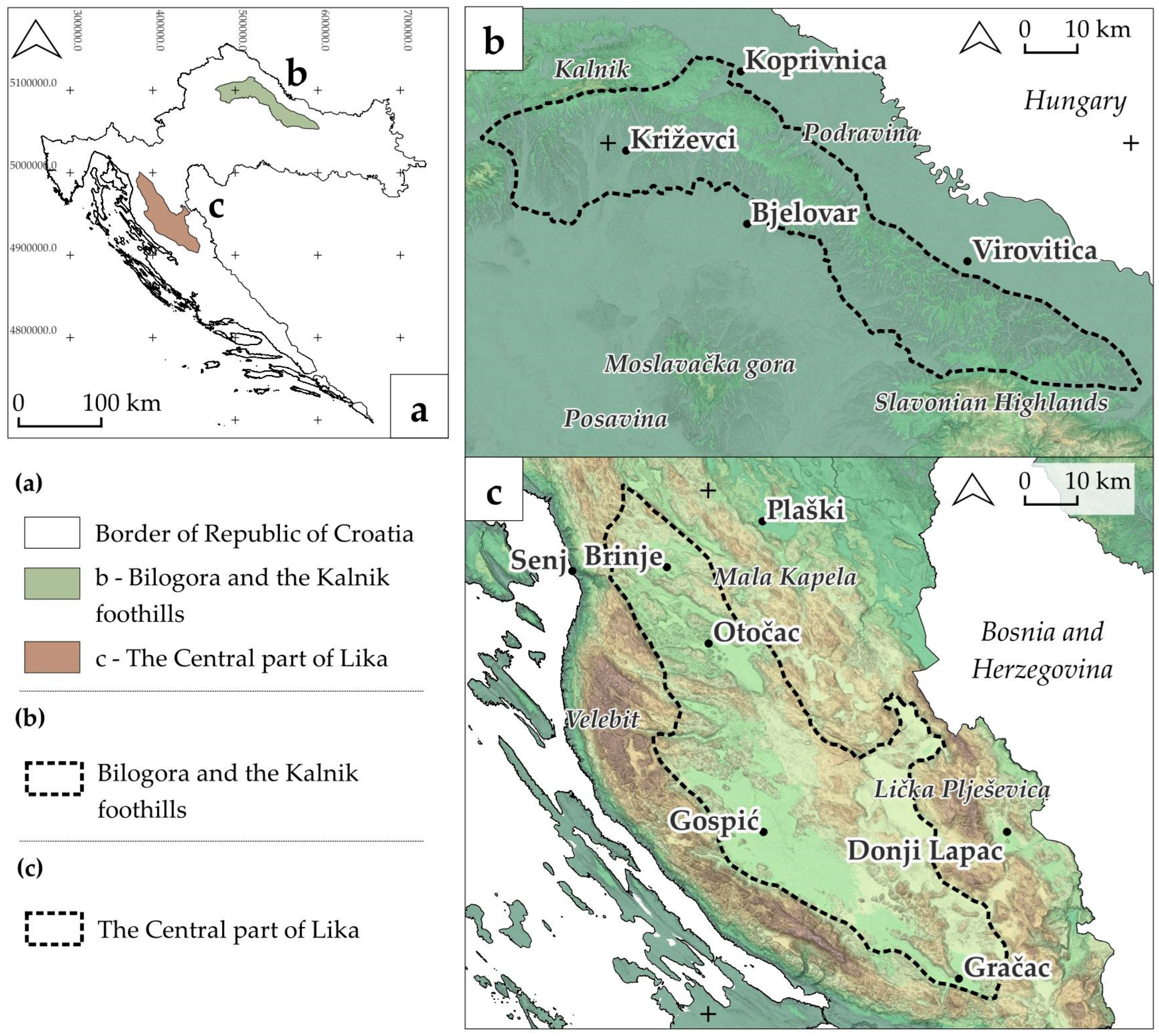
Figure 1. The location of both regions in the Republic of Croatia (a), geographical location of (b) Bilogora and the Kalnik foothills, and (c) the central part of Lika.
Land 14 02068 g001
Figure 2. Diagram of research work process (Bilogora and the Kalnik foothills).
Land 14 02068 g002
Figure 3. Diagram of research work process (the central part of Lika).
Land 14 02068 g003
Figure 4. (a,b) Comparative view of Bilogora (and Kalnik) in different landscape regionalizations.
Land 14 02068 g004
Figure 5. (a,b) Comparative view of Bilogora (and Kalnik) in different geographic regionalizations.
Land 14 02068 g005
Figure 6. Bilogora (and Kalnik) in geomorphological (a) and agricultural (b) regionalization.
Land 14 02068 g006
Figure 7. (a,b) Comparative view of Lika in different landscape regionalizations.
Land 14 02068 g007
Figure 8. (ad) Comparative view of Lika in different geographic regionalizations.
Land 14 02068 g008
Figure 9. Comparative view of Lika in different natural (a) and cultural (bd) regionalizations.
Land 14 02068 g009
Figure 10. Overlapping regionalizations in the Bilogora area.
Land 14 02068 g010
Figure 11. Overlapping regionalizations in the Lika region.
Land 14 02068 g011
Disclaimer/Publisher’s Note: The statements, opinions and data contained in all publications are solely those of the individual author(s) and contributor(s) and not of MDPI and/or the editor(s). MDPI and/or the editor(s) disclaim responsibility for any injury to people or property resulting from any ideas, methods, instructions or products referred to in the content.