1. Introduction
Anthropogenic climate change has triggered oceanic acidification and an increased frequency of extreme weather events, prompting a basic international consensus on capturing and sequestering carbon emissions [
1]. Terrestrial ecosystems have a significant carbon sink function, annually absorbing approximately 28% of anthropogenic CO
2 emissions [
2], sequestering them as organic matter, thereby effectively reducing atmospheric CO
2 concentrations [
3,
4]. Land-use change has emerged as a primary driving force influencing terrestrial ecosystem services, spatial patterns, and the overall provision of carbon storage [
5,
6,
7,
8]. Shifts in land-use patterns affect regional carbon stocks by altering surface material cycles, energy flows, and the potential for soils and vegetation to sequester carbon [
9,
10]. Some studies have indicated that approximately 19% of cumulative global CO
2 emissions from 1850 to 2019 were attributed to land-use change activities [
11]. Furthermore, research has shown that natural ecosystems such as forests and grasslands in the Northern Hemisphere’s mid-to-high latitudes, particularly forest ecosystems, possess a formidable carbon sequestration capacity, absorbing 2–3 billion tons of carbon dioxide annually, rendering them a major spatial carrier of carbon sink on land [
12,
13]. Major forest nations, notably China, Brazil, Canada, the Democratic Republic of Congo, Russia, and the United States, play a pivotal role in global carbon cycling, accounting for a substantial 51% of global emissions, 56% of total carbon sequestration, and 60% of net carbon flux [
14]. To address climate change’s impact on human well-being and sustainable socioeconomic development, The Intergovernmental Panel on Climate Change (IPCC) has established comprehensive guidelines for anthropogenic greenhouse gas emissions and removals [
15,
16], enabling governments worldwide to optimize land resource management and enhance carbon sink capacity. In 2021, representatives from 145 nations collectively endorsed the
Glasgow Leaders’ Declaration on Forests and Land Use. This landmark declaration articulates a shared commitment among signatories to safeguard and expedite the restoration of forests and other terrestrial ecosystems, with a pledged deadline of 2030 to halt and reverse forest loss and land degradation [
17]. Against this backdrop, China introduced its “dual carbon” goals in 2020 (peaking carbon emissions by 2030 and achieving carbon neutrality by 2060) with specific objectives such as increasing national forest land coverage to approximately 25% and stock volume to 19 billion m
3 by 2030, and surpassing non-fossil energy usage above 80% by 2060 [
18]. These outlined actions demonstrate the critical need for continually strengthening carbon sink capacity in order to achieve China’s “dual carbon” goals. China’s “dual carbon” goal will inject vital impetus into the global climate governance process [
19]. Consequently, exploring the effect of land-use changes on carbon sequestration in China’s terrestrial regional ecosystems, probing the driving factors behind ecosystem carbon stocks, and exploring the optimization of spatial patterns to enhance terrestrial ecosystem carbon sequestration is of paramount importance for achieving the “dual carbon” targets and addressing global climate change [
20].
Currently, the approach for assessing carbon stocks in terrestrial ecosystems in the literature encompasses field surveys, remote-sensing inversion, and model simulations [
21]. Field surveys directly and accurately measure carbon stocks in small-scale ecosystems but entail substantial workloads and time consumption [
22]. Remote-sensing inversion is solely suitable for analyzing specific ecosystems at a macro scale [
23,
24]. The model simulation method is an effective approach for estimating the dynamic changes in ecosystem carbon storage at multiple scales. Simulations offer ease of operation and faster speeds while enabling spatiotemporal quantitative analyses and intuitive visualization of carbon stocks across different scales [
25]. The InVEST model stands out among various models due to its strong versatility, low demand, and other features. In particular, its carbon storage module provides more accurate estimations compared to other models [
26], making it widely utilized [
27,
28]. A growing quantity of studies are combining the InVEST model with Flow-direction-based Landscape Urban Simulation (FLUS) [
29], Cellular Automata–Markov (CA–Markov) [
30], Conversion of Land Use and its Effects at Small region extent (CLUE-s) [
31], and CLUMondo [
32] models to forecast future carbon stocks and land-use spatial distribution under multiple scenarios. Additionally, Lyu et al. [
33] have demonstrated that coupled models can effectively improve simulation accuracy.
From the current research progress of domestic and international scholars, the academic community has achieved fruitful results in land-use change, carbon stock estimation, and multi-scenario prediction. However, traditional commonly used models are hard to employ to flexibly forecast changes at the patch level in a range of land-use types and lack in analyzing the driving factors and influence mechanisms. Overall, the existing literature provides important references for our related studies but further expansion and improvements are needed in the following aspects: (1) Carbon density data are often derived from previous studies, which may differ significantly from field measurements [
25,
34,
35,
36]. Scholars tend to analyze carbon stock changes at the horizontal scale, overlooking the spatial heterogeneity and the influence of multi-dimensional environmental gradients in complex terrain regions. (2) The PLUS model can precisely simulate non-linear relationship changes in land-use change processes [
37]. It outperforms models such as FLUS, CA–Markov, and CLUE-s in terms of simulation accuracy, cell-scale changes, and landscape pattern similarity [
38]. The PLUS model has a high degree of coupling with the InVEST model and is currently an effective means for land-use change scenario prediction [
39]. Consequently, numerous studies have coupled the InVEST model with the PLUS model, not only assessing ecosystem service functions but also predicting various future land-use scenarios and enabling the evaluation of ecosystem service capabilities under future multi-scenarios [
28,
32,
40]. However, some scholars have pointed out that the PLUS model cannot effectively simulate when it involves climate factors, natural factors, and dynamic socioeconomic policies [
41]. (3) Land-use scenario simulation is an important method for achieving optimal land-use allocation [
42]. Structural prediction in land-use scenario modeling mainly includes the Markov model [
43], System Dynamics (SD) model [
44], and GMOP model [
45]. Among these, the GMOP model can handle uncertainties in objective functions and constraint conditions, integrating multi-objective linear programming and grey prediction theory, which can better reflect dynamic evolution characteristics [
46]. However, rapid urbanization has produced complex land-use and carbon storage distribution patterns at multiple scales. In addition to socioeconomic and natural factors, specific policies also have an impact on land-use change [
47]. The Markov chain built into the PLUS model used in the existing study of carbon reserves cannot satisfy the prediction and simulation of non-linear quantities for ecosystem service types like carbon storage, making it difficult to respond to environmental protection policy demands and objectively coordinate the research area’s ecological and economic benefits to optimize land-use structure [
48]. Therefore, coupling the GMOP model with the PLUS model not only leverages the unique advantages of both models in structural optimization, scenario setting, and spatial allocation but also effectively avoids the uncertainties and limitations of the PLUS model. (4) The existing literature trends toward analyzing the driving mechanisms of carbon stocks solely from the land-use change perspective, lacking in-depth research on the impact of natural and socioeconomic factors [
49]. Geodetector is a commonly used method for investigating driving factors [
50]. However, most scholars [
51,
52] discretize continuous independent variables based on subjective experience but the parameters derived from this classification approach may not necessarily be the optimal parameter. Song et al. [
53] proposed an optimum parameter-based geo-detector (OPGD) that can identify the optimal combination of spatial scale parameters and spatial data discretization classification methods as well as identify the driving factors of phenomena and their spatial heterogeneity distribution characteristics, largely compensating for the deficiencies of traditional geographical detectors. Given this, regional soil data can be used to calculate soil carbon density, and the prediction results of the GMOP model can be applied to the structural prediction step of the InVEST-PLUS model. This model’s combined approach not only preserves the unique functions of each model but also effectively compensates for the single model’s deficiencies, thereby enabling reasonable and objective predictions of carbon storage changes under future scenarios. Additionally, adopting the OPGD model will address the deficiencies of traditional carbon storage research in exploring driving mechanisms and provide a reasonable and scientific basis for making decisions in order to optimize land spatial patterns and enhance regional carbon storage.
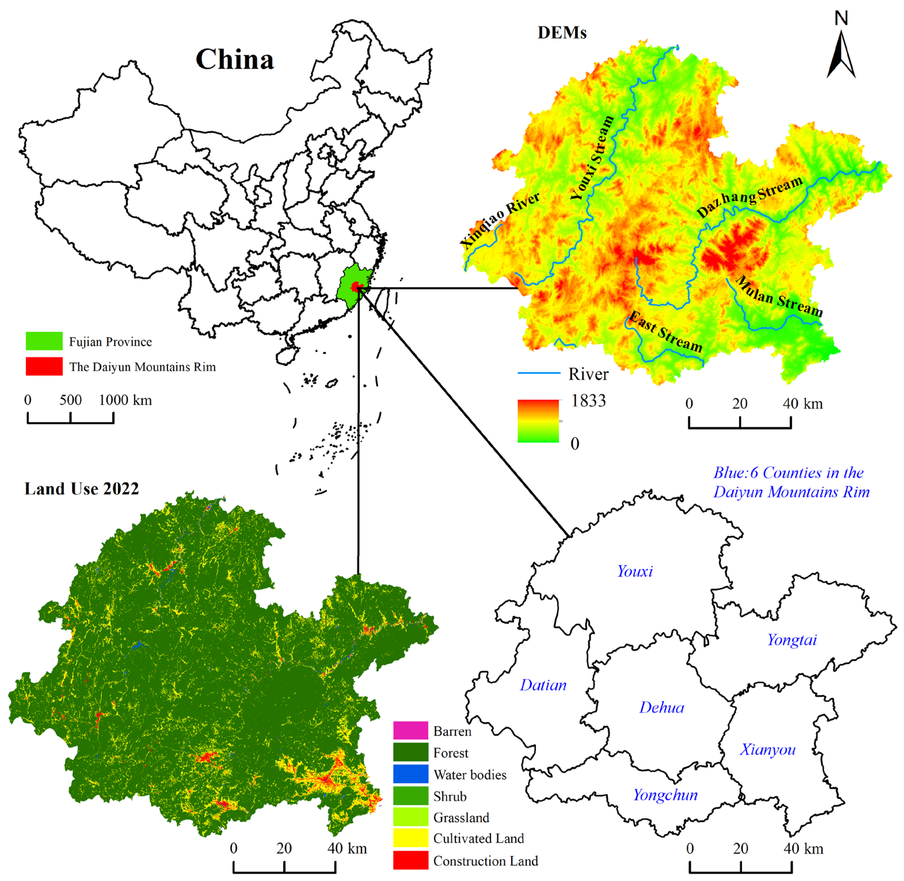
The hilly regions of Southern China are an important carbon storage area in the country [
54]. To promote economic growth through the utilization of ecological assets, a green economic industry alliance was established in 2023 by the six counties of the Daiyun Mountain’s Rim in Southern China, namely Dehua, Yongchun, Yongtai, Datian, Youxi, and Xianyou. This region is characterized by its abundant biodiversity and extensive river networks within its mountainous forest ecosystems [
55], possessing invaluable ecological significance. As the basic units of China’s national economy, counties play an irreplaceable role in optimizing the economic structure, promoting social stability and eco-environmental governance. However, China’s prioritization of urbanization at the county level has compressed ecological spaces, leading to an increase in CO
2 emissions and a decline in ecological quality and carbon stock across numerous regions in the southern hilly areas [
56,
57]. Scientifically assessing and enhancing the ecological resource endowment of this region—particularly the carbon sequestration potential of various land-use types in terrestrial ecosystems—while optimizing the spatial pattern of land use to unlock development potential has become an urgent realistic issue. This issue not only pertains to the sustainable development of regional green industries but is also a crucial component in responding to global climate change and meeting the “dual carbon” goals. Accordingly, this study proposed an integrated framework comprising GMOP, InVEST, PLUS, and OPGD models, optimizing the land-use allocation from the dual perspectives of ecological preservation and economic growth, simulating and projecting future land-use patterns across multiple scenarios over the next decade, i.e., 2032. Through investigating the spatiotemporal evolution of carbon stocks and land-use types and detecting drivers of carbon storages from an optimal parameter perspective to rationally optimize the national spatial pattern, this approach is not only crucial for achieving the “dual carbon” goals and supporting the sustainable development of green industries in the Daiyun Mountain’s Rim but will also provide a significant reference for seeking a balance between ecological resource conservation and economic growth in other similar southern hilly areas of China, contributing to the global effort in response to climate change.
4. Discussion
4.1. Feasibility Analysis of Carbon Storage Estimation
The accuracy of the carbon density data used in the InVEST model to estimate carbon stocks determines the accuracy of the carbon stocks estimation results. The data used for carbon density calculation in this paper mainly come from the World Soil database and the corresponding parameters of the National Ecological Science Data Center. In comparison with the relevant literature, Tong et al. [
73] summarized the research results of land-use data, soil carbon sink, and land-use management carbon sink, and concluded that the 1 m soil carbon density in Fujian Province in 2020 was 125.32 t·hm
−2. In contrast, this study’s carbon density at 0.3 m for various land-use types ranges from 45.23 to 51.05 t·hm
−2, which is higher than the previous results but the difference is not large. The primary reason is that the forest vegetation coverage in the study area is high and the biodiversity is rich, resulting in higher soil carbon density than the average level in Fujian Province. Based on the soil organic carbon data obtained from a multi-objective regional geochemical survey, Wang [
74] calculated the average carbon density of 0.2 m soil organic carbon in Fujian Province as 34.45 t·hm
−2 using the method of unit soil carbon amount. The average carbon density of soil organic carbon of different land-use types ranges from 29.84 to 36.54 t·hm
−2, which is very close to this study’s carbon density at 0.3 m of various land-use types ranging from 45.23 to 51.05 t·hm
−2. Zeng et al. [
75] sampled the topsoil of residential land in Nantai Island, Fuzhou City, and measured the topsoil organic carbon density of residential land as 43.48 t·hm
−2, which is also very close to the construction land’s value of 45.23 t·hm
−2 soil carbon density in this study. The comparative analysis with existing research results shows that the soil carbon density calculation method and the final carbon density values adopted in this paper are quite consistent with the results calculated based on measured data or official data, displaying the high accuracy of this method and its ability to depict carbon stock changes in the Daiyun Mountain’s Rim.
4.2. Drivers of Spatiotemporal Patterns in Land-Use Change and Carbon Storage
Over the past 30 years, different land-use types and carbon stock changes in the Daiyun Mountain’s Rim have shown dynamic fluctuations, mainly due to the joint influence of multiple factors such as agricultural policies, economic growth, and population migration. Han Y. et al. [
65] found in their research that the increasing and then decreasing trend of carbon stocks in the Zhongtiao Mountain ecosystem in southern Shanxi from 2000 to 2016 may be related to ecological reconstruction projects and policies like the Grain for Green, which verifies the findings of this study. Specifically, the Grain for Green program and the diversification of rural livelihoods caused the area under cultivation to shrink and the area covered by forests to grow, and carbon sequestration increased slightly. From 1997 to 2002, the national government substantially increased agricultural investment, while Fujian Province simultaneously implemented a comprehensive land utilization plan (1997–2010), projecting an additional 72,000 hectares of cultivated land. During this period, agricultural activities dominated the rural economic structure [
76], resulting in a resurgence of arable land area, a decline in forestland, and, consequently, a reduction in carbon storage capacity. During the 2002–2012 interval, the nationwide implementation of the first Grain-for-Green policy initiative prompted a significant exodus of rural labor. In Fujian Province, the collective forest rights system reform was instituted in 2003. The national government proposed the “West Coast Economic Zone” strategy in 2004 (elevated to national strategy status in 2009), followed by the formulation of the West Coast Urban Agglomeration Development Plan in 2010. Throughout this decade, under the accelerated urbanization and regional development framework centered on Xiamen–Zhangzhou–Quanzhou, cultivated land diminished substantially, while forestland expanded rapidly, leading to a recovery in carbon storage. From 2012 to 2022, the national focus shifted predominantly toward ecological development. This period witnessed the implementation of agricultural supply-side reforms and rural revitalization policies. Fujian Province successively gained approval as an Ecological Civilization Pilot Demonstration Zone (2014) and National Ecological Civilization Experimental Zone (2016). Concurrently, several national initiatives bolstered Fujian’s economic development, including the “China (Fujian) Pilot Free Trade Zone”, the “21st Century Maritime Silk Road Core Area”, the “Fuzhou New Area”, and the “Fujian–Xiamen–Quanzhou National Independent Innovation Demonstration Zone”. During this phase, cultivated land experienced renewed growth while forestland decreased, resulting in a decline in carbon storage capacity.
The areas of significant carbon stock changes in the Daiyun Mountain’s Rim are concentrated in the intersection areas of forest, cultivated, and construction land. The main reason for this stems from the shift in cultivated and forest land to construction land in six counties, while the expansion of cultivated land is also largely a result of the reduction in forest land. Among them, in counties with less cultivated land and abundant forest resources—such as Yongchun County, Youxi County, and Dehua County—large tracts of forest land area were transferred to construction and cultivated land during economic development, incurring an immense ecological cost. In Xianyou County, where cultivated land resources are relatively abundant, the conversion mainly encroached upon the agricultural spaces surrounding urban areas and water bodies within cities. From 1992 to 2022, the area of forest land transferred to cultivated land reached as high as 586.23 hm2, resulting in the greatest loss of carbon stocks of 4.424 Tg. Forest land transferred to cultivated land was the predominant type of land-use change during this period, also driving carbon stock changes in the region. The carbon stock changes resulted from the aforementioned conversions among different land types, essentially reflecting the interplay among forest, cultivated, and construction land utilization. This fully demonstrates that human activities have profoundly influenced the spatial distribution pattern of carbon stocks in the Daiyun Mountain’s Rim. Rational planning of cultivated and forest land is of paramount importance for existing policy guidelines.
The GMOP-PLUS model employed in this study can more effectively resolve the quantitative and spatial conflicts among different land-use types, achieving an approximate optimal solution for the objective [
77] while also adhering more closely to objective reality. Compared to 2022, the carbon storage projections for all three scenarios (economic priority development scenario, ecological priority development scenario, and coordinated economic–ecological development scenario) in 2032 exhibited a certain increase, whereas the carbon stock loss under the natural development scenario exceeds the carbon stock gains across other scenarios, indicating that the natural development scenario is inadvisable. The cultivated land area decreased in all three scenarios, reflecting the inevitable trend of decreasing cultivated land area under the dual context of economic growth and ecological environmental conservation. In the ecological priority development scenario, projections for 2032 indicate that construction land area would remain stagnant compared to 2022 levels, revealing a significant disparity with actual regional development requirements, thus rendering this scenario less viable. While both the coordinated economic–ecological development and economic priority development scenarios maximize construction land area while maintaining minimum arable land requirements, the former demonstrates notable advantages in carbon storage capacity. Given Fujian Province’s strategic positioning as a national ecological civilization pilot zone, the economic–ecological synergistic development scenario better aligns with future regional development needs, emerging as the optimal developmental pathway. According to scholarly research, increasing the planting density of advantageous tree species, thereby increasing the carbon density of forest land, is an effective pathway to enhance regional carbon storage [
41]. Concurrently, this study also argues that through crop rotation, improving crop yields per unit area, and straw mulching techniques, not only can these increase the economic output efficiency of farmed land but they also enable the full utilization of light and temperature resources, thereby increasing the carbon storage of cultivated land. Furthermore, elevating the spatial resource utilization rate and economic output efficiency per unit area of construction land will help to curb the disorderly expansion of this land. The above measures aim to promote intensive and efficient land utilization, providing an effective way to resolve the land-use conflicts between economic growth and ecological civilization construction.
This study identified two key driving factors and three major driving factors affecting carbon stocks in the Daiyun Mountain’s Rim during various periods, with the single-factor exploration and their interaction with other factors exhibiting the strongest explanatory power for carbon storage, indicating that the effects of the factors affecting carbon stocks in this region were generally stable. However, the factor combination with the strongest explanatory power in the interaction exploration shifted from slope and mean annual temperature to slope and night light index, reflecting that although natural factors maintain a dominant influence on carbon storage, their impact is declining, while the influence of socioeconomic factors is markedly increasing. This further substantiates the deepening impact of human activities on regional carbon stocks. The root cause lies in human’s ability to adapt to and exploit nature, overcoming limitations posed by slope, temperature, and other natural environmental constraints, leading to the utilization of more land and, consequently, reducing regional carbon stocks. In the context of regional carbon stock management, the impact of human activities must be highly prioritized, and corresponding measures should be adopted to mitigate their adverse effects on carbon storage.
4.3. Suggestions for Ecosystem Synergy and Co-Benefits
Terrestrial ecosystems are sensitive and fragile, vulnerable to both natural and anthropogenic disturbances [
78]. How to keep terrestrial ecosystems stable and orderly while enhancing their carbon fixation ability is an urgent problem to be solved under the background of ecological space compression in the Daiyun Mountain’s Rim and similar areas in Southern China. The research findings indicate that interactions among various driving factors can intensify their impact on the spatial heterogeneity of carbon stocks, necessitating fully utilizing the synergistic effects between various driving factors. For instance, based on the findings that regions with high topographic indices, such as high altitude and high slope, have strong carbon sequestration capabilities, future efforts in the Daiyun Mountain’s Rim should focus on implementing and consolidating vegetation protection and increasing vegetation planting density in areas with high topographic indices—particularly mountainous regions above 300 m in elevation—to prevent forest land transfer to other land-use types. However, the preceding analysis focuses on ecological impacts, and human needs must also be considered. Economic growth follows the optimal allocation law of scarce resources across different competitive purposes [
79], while ecosystem products—such as regulating ecosystem products (such as climate regulation, water conservation, etc.) and cultural ecosystem products (such as recreation, aesthetic value, etc.) [
80]—inherently lack exclusivity and scarcity unless exploited. In 2022, General Secretary Xi Jinping emphasized that forest lands are reservoirs, banks, granaries, and carbon sinks. Accordingly, by granting market scarcity to ecological products through technical means or other innovative forms, transforming them into people’s income, and transforming the competitive relationship between humans and ecosystems into a collaborative one, this is an important path to balance economic growth and ecological environmental preservation in the Daiyun Mountain’s Rim. For instance, bolstering the bamboo industry in Jian’ou and Yong’an Counties, Fujian could raise bamboo farmers’ incomes [
81]. In addition, future research could focus on cultivating understory agriculture and pursuing adaptive and regional research and study activities with biodiversity as the theme. These are all important measures to realize the value of ecological goods. Given this, the regional green economic industry alliance in the Daiyun Mountain’s Rim should manage and operate the terrestrial ecosystem in the Daiyun Mountain’s Rim based on ecological environmental protection, effective utilization of ecological resources, enabling socio-ecological synergy, mutual benefit, and win–win results, supporting the realization of “dual carbon” goals to combat climate change.
4.4. Limitations and Future Enhancements
This study calculated soil carbon density using its own research area of soil data, which better reflects the actual conditions of the study area compared to most studies that cite previous research results. Although soil organic carbon has stability, soil organic carbon density changes with climate and environmental changes. However, due to data limitations and the enormous sampling workload, the carbon density data used in this study are not the carbon density data for each year during the study period; therefore, there is some loss of accuracy in estimating annual carbon storage, and future research should focus on exploring carbon density of different land-use types over the years. Secondly, this study mostly used spatial data, with resolutions of 30–1000 m, and higher resolution data could be used in the future.
The study area encompassed six county-level administrative units, representing a relatively small scale. Future research could expand to provincial or national scales. While this study employed the PLUS model, which is suitable for small-scale analyses, CLUMondo is more appropriate for larger-scale studies. CLUMondo demonstrates superior applicability in predicting ecosystem service multi-functionality under various future scenarios as it represents an enhanced iteration of the CLUE model. Its distinctive feature lies in incorporating land system changes driven by goods and services demand, while comprehensively accounting for human activity intensity and socioeconomic development impacts on land-use patterns.
Considering that PLUS is predominantly utilized by Chinese researchers while CLUMondo is more prevalent internationally, and given China’s unique developmental context of balancing economic growth with environmental protection, this study established four future development scenarios. Moving forward, the selection between PLUS and CLUMondo models should be guided by study area scale and regional characteristics, with scenarios tailored to local development trajectories.
5. Conclusions
Based on seven periods of land-use data from 1992 to 2022, along with natural factor data, socioeconomic data, and accessibility data, this study used an integrated GMOP, PLUS, InVEST, and OPGD modeling approach to simulate carbon storage under multiple scenarios in the Daiyun Mountain’s Rim for 2032, which better aligns with regional policy planning and actual conditions. Based on the 30-year-long time-series data, the model systematically analyzed the characteristics and spatial heterogeneity of land-use and carbon storage changes in this region, introducing a terrain position index perspective to deepen the understanding of carbon storage spatial distribution patterns, and detected the driving mechanisms of carbon storage changes from multiple dimensions of natural–socioeconomic–road accessibility factors. The conclusions are as follows:
(1) Vegetation cover in the Daiyun Mountain’s Rim is predominantly forest land, followed by cultivated and construction land. From 1992 to 2022, forest land area in the region decreased significantly by 41,890.14 hm2, while cultivated and construction land areas increased by 27,152.1 hm2 and 13,612.41 hm2, respectively. In 2032, under the natural development scenario, forest land area will continue to decrease significantly, while the areas of cultivated, shrub, and construction land will further expand. However, under the economic priority development scenario, ecological priority development scenario, and economic–ecological coordinated development scenario, cultivated land area will exhibit a declining trend;
(2) From 1992 to 2022, the region’s carbon stocks displayed a fluctuating trend of increase and decrease, with a cumulative decrease of 3.3 Tg. The average carbon storage ranged from 122.24 to 124.8 t·hm−2 and the rate of carbon storage decrease accelerated in the last 10 years. Youxi County experienced the largest decrease in carbon storage, while Xianyou County generated the greatest amount of carbon stocks from cultivated land transferred to forest land. Carbon storage initially increased and then decreased with increasing altitude, slope, and terrain position index, exhibiting a decreasing trend after the turning points of 742 m altitude, 23.7° slope, and 0.74 terrain position index. The average carbon storage increased with increasing altitude, slope, and terrain position index. Compared to 2022, carbon storage in 2032 will decrease by 2.8 Tg under the natural development scenario but increase by 0.29 Tg, 2.62 Tg, and 1.65 Tg under the economic priority development, ecological priority development, and economic–ecological coordinated development scenarios, respectively. The spatial distribution of carbon stock variations in the region exhibits a scattered pattern;
(3) Land-use changes in the region and its six counties mainly manifested as mutual conversions among forest, cultivated, and construction land, with forest land transferred to cultivated land being the primary type and dominant type of carbon storage change. Overall, approximately 7.2% of the land-use types underwent conversion, with forest land being the primary outgoing land type and cultivated and construction land being the primary incoming land type;
(4) The key factors influencing carbon storage in the region are mean annual temperature and night light index, with the major driving factors being elevation, slope, and population density. There are six secondary driving factors and seven other factors. Multi-factor interactions have significantly higher explanatory power for carbon storage heterogeneity than individual factors, with the interactions between mean annual temperature, night light index, elevation, slope, population density, and other factors being the most important interactive dominant factors. The effect of natural factors on carbon stocks is declining, while the influence of socioeconomic factors is rising.
In summary, the ecosystem carbon stocks in the Daiyun Mountain’s Rim experienced an overall decline from 2019 to 2022, mainly influenced by agricultural policies, economic development, and population mobility. To enhance regional carbon storage, a balance should be sought between ecological protection and economic development, and the following measures are proposed: First, precautions should be used to protect and manage vegetation in the Daiyun Mountain’s Rim, particularly the vegetation at high altitudes and on steep slopes. Second, the utilization rate of light and temperature resources in cultivated land, as well as the planting density of advantageous tree species, should be improved. Third, the scarcity of ecological products in the region should be enhanced through technological means or other innovative forms, promoting the sharing of benefits between the ecosystem and human society. This will not only avoid competition between the two but also create economic value for incentive protection. This approach will not only increase regional carbon storage but also provide support for achieving the “dual carbon” goals and addressing climate change, offering a valuable reference for sustainable development and ecological environment protection decision-making in the hilly areas of Southern China.


