Abstract
Fishing ports are important fishery production platforms, and the transformation of these has had a profound impact on the fishing industry. A reasonable classification solution is crucial for scientific understanding, development, and management of fishing ports. Current research on the use of spatial distributional characterization and the construction of a classification system for fishing ports to improve their management is limited. Therefore, in this study, a fishing port classification system was constructed using remote sensing images, with fishing port boundaries accurately extracted for classification. Using graphical summarization, fishing ports were classified into five types, including inland, estuarine, shoreline, gulf, and islands. A port type identification system was also constructed based on distance from the shoreline, water area, and circulation. Finally, fishing port characteristics and differences were investigated based on spatial superposition. The results demonstrate that shoreline and gulf types are the most prevalent fishing port types along the Chinese coast, accounting for 43% and 26% of the total number of fishing ports, respectively. This provides a strong foundation for China’s fishery production, processing, and trade. Through the establishment of a comprehensive scientific classification system, fishing port management can be modernized, supporting the sustainable development and utilization of coastal zones.
1. Introduction
Currently, the State of World Fisheries and Aquaculture statistics show that China is the world’s largest fishery producer; its fish production output accounted for 34% of the global total in 2018 [1]. Simultaneously, China also has the largest number of fishing vessels and fishermen globally. Therefore, fishing port construction ensures fishery production safety and provides crucial support for the urban and rural development of coastal fishing zones. Between 1991 and 1997, China constructed 83 mass fishing ports, and between 1998 and 2015, 148 central and first-class fishing ports were constructed. China is the largest developing country, with an abundance of aquatic resources and a fishery industry that has been rapidly developing since the 1990s. Over the past three decades, the Chinese fishing industry has predominantly relied on an intensive exploitation approach, vigorously harvesting fishery resources to rapidly fulfill short-term socio-economic needs [2]. Artisanal and small-scale fisheries are the main modes of fishery production. Fishing harbors are mostly mass fishing harbors for mooring, production, and shelter, with low economic value and severe environmental pollution, resulting in large-scale waste of resources and ecological damage, which is consistent with the development of fisheries in most coastal developing countries. Since the dawn of the 21st century, China’s marine fishery has undergone a rapid transformation and now entered a high-quality development stage, with continuous improvements in fishing port functionalities. Therefore, the construction of multifunctional modernized fishing ports, alongside a scientific approach toward management improvement and production efficiency, have become the most pertinent issues to be addressed. In the global fishing industry, China stands out as a highly politicized nation. Criticisms directed towards China often stem from differences in practices compared with other regions worldwide, including developed countries [3]. The development of scientifically efficient fishing port management practices has also become a global focus for coastal countries and regions as technology advances and the demand for fish products increases.
The SOFIA 2020 report shows that global per capita fish consumption has reached a new record of 20.5 kg per annum, and the growth rate is expected to be increasingly high. Globally, almost three billion people rely on fish for at least 20% of their per capita animal protein intake [4]. Fisheries and aquaculture create tens of millions of jobs globally, supporting the livelihoods of 10–12% of the global population. The operation of fishing ports also has a considerable influence on fishermen’s livelihood security, community economic development, and regional employment rates. As key nodes in the global fishing supply chain, fishing port location, operational status, and distribution directly affect the global fish trade. Spatial classification refers to the process of categorizing geographic spaces or spatial units based on specific attributes or criteria such as location, shape, size, or other relevant characteristics. In the specific context of exponential population growth and food security becoming a matter of global concern, the spatial classification of fishing port types is of paramount practical significance and value for promoting the specialization, efficiency, and sustainable development of such ports. For example, such classification enables improved consideration of the geographic environment and location factors, such that fishing port construction and development can better adapt to natural and human conditions, and geographers can provide professional information support for high-quality fishing port planning and construction. From the industrial development perspective, this approach, according to fishing port types, could provide fishermen and enterprises with more specialized and personalized services, clarify key functionalities, and improve fishery production efficiency. From the coastal zone management perspective, fishing port type classification could assist in formulating different coastal zone development plans according to fishing port location and resource characteristics. This has the potential capacity to integrate multiple diverse coastal zone requirements spanning ecological, economic, and social development to ensure a more sustainable approach to coastal zone development. From the global fishery development perspective, the construction of a fishing port classification system will assist international fishery organizations in better coordinating cooperation and exchange, facilitating global scientific planning, improving fishery management, and promoting future development, utilization, and protection of fishery resources.
Existing port classification studies emphasize taking a sample of diverse ports and classifying them for comparison so that ports with the same development potential are comparable. Developing a port-classification methodology helps to identify ports with similar management characteristics. Adenso-Díaz classified the Spanish port system based on the F-AHP model to improve the efficiency and competitiveness of container port operations [5]. Ports have different roles and categorizations, and constructing a comprehensive global framework for their classification reduces port homogeneity and helps address the functional and operational strengths and weaknesses of similar ports [6]. Simultaneously, ports interact with cities in a multidimensional manner, the functions of which are closely linked to city-based economic activities. Multimodal seaport nodes are related to cities and generate considerable employment and industrial activities, which also affect national and regional development [7]. Therefore, a typology of ports helps formulate appropriate plans for development based on the characteristics and context of that port. This maximizes the port’s advantages and improves its overall role. The complexity and diversity of port functions in terms of the organizational, operational, physical, spatial, legal, and regulatory dimensions have resulted in the lack of a single classification approach to global port management. Considering the diversity of factors influencing port development alongside high sector competitiveness, the development of a port classification system is expected to enable an improved understanding of facility types in terms of management requirements, challenges encountered, and identification of the most appropriate management model for port development. Various methods can be used to classify ports. However, no authoritative definition of port tasks, functions, institutions, or organizational management exists, and there is no need for a single port classification, which could stifle port management research initiatives [8]. The majority of current studies categorize ports in terms of size [9], cargo throughput [10], service scope or strategic location, and governance requirements [11]; all such studies focus on selecting improved port management approaches. With the development of economic globalization, port development has also undergone profound changes, and port service functions have gradually expanded toward storage, collection and distribution, information transmission, and value-added services. Additionally, ports have become a key link in the integrated logistics service chain, comprising international logistics centers that provide more holistic, high-value-added services to customers. Fishing port service functions are gradually transforming into fishing supply, gear manufacturing, storage, processing, and trade centers, becoming comprehensive platforms for fishery production. According to port type classification, port functions are diverse at the spatial level, which makes fishing ports consistent with container ports. Therefore, classifying fishing ports is conducive to a more in-depth understanding of their characteristics and functional advantages. This emerging functional transformation also indicates a change in the future development direction of fishing ports, making research in this field more prominent. The establishment of a scientific port classification framework helps understand the advantages and disadvantages of ports and clarifies the characteristics of fishing ports so that more appropriate port management methods can be found.
Regarding the current state of the art, the majority of international research on fishing ports can be divided into two categories: that of the developed and developing countries, where most developed countries have focused on the construction and management of modernized fishing ports [12], the economic development impact on commercial fisheries [13], and technological research and development of economic fish species [14,15,16,17]. Studies targeting developing countries have predominantly focused on small-scale fisheries [18], fisheries employment [19], sustainable fisheries development [20], and environmental pollution [21]. The government is responsible for fishing port management in China, and such ports are categorized into central, primary, secondary, tertiary, and other fishing ports, of which central and primary fishing ports are constructed using central investment. This classification model is similar to that of the United Kingdom, Ireland, India, and other countries and is also based on fishing port size, throughput, and service scope. Unlike the classification of ports, the classification of fishing ports also considers the element of effective water area coverage. Port type classification is predominantly focused on container ports, and research in this field is conducted from the perspectives of functionality, institutions, organizations, and roles. However, the spatial distribution and classification of port types have not yet been investigated. The most substantial difference between fishing and container ports is their importance to food and livelihood security.
As the fishing industry evolves from a primary to a higher level of industrialization, the social value of fishing ports also changes. Establishing a classification system for fishing ports based on their location and hydrological conditions and understanding the differences in their geographical elements can assist coastal regions in formulating rational plans for the utilization of fishing ports [22]. Fishing organizations can also discern the types of fishing production activities suitable for local development based on regional characteristics and socio-economic factors. Most fishing ports face environmental issues; the advantages and challenges they face during operations are also similar [23]. Areas with long coastlines and open seas are suitable for developing international or domestic trade and marketing centers; regions with rivers have superior land-sea communication capabilities; and areas with natural shelter from the wind have a higher probability of accommodating more vessels for equipment adjustment. A thorough understanding of the spatial characteristics of fishing ports can play a positive role in issues such as environmental management, self-regulation systems, and port dredging. Most marine engineering projects are not in open waters but are concentrated in areas where the ocean meets the land, such as ports, estuaries, or wharves [24]. The fishing economy is the foundation for the development of the maritime economy, and with the continued growth of the seafood market, the expansion of ports is an issue that governments must consider. However, the expansion of fishing ports is not limited to increasing the area of land; their shelter capabilities must also be taken into account. The construction of ports and breakwaters can lead to changes in the beach environment and influence shoreline erosion, respectively [25]. The construction of breakwaters must consider the ecological and economic impacts. As breakwaters are public projects, their construction must consider the characteristics of mechanical engineering as well as the advantages and disadvantages of their geographical location. In addition, artificial breakwaters have limited resistance to waves, are expensive, and are not a long-term effective solution, whereas utilizing the natural advantages of the area for construction can reduce costs and enhance the port’s shelter and capacity in conjunction with modern technology. In summary, the classification of fishing ports is fundamental for conducting fishing production activities and enhancing the competitiveness of fishing ports. To avoid the ecological pressure caused by the blind expansion of fishing ports [26], establishing a fishing port classification system from a macro perspective is conducive to the sustainable and high-quality development of the fishing economy. Because of the demand for fishery resources and the effective coverage of water areas, fishing port shoreline locations and spatial distribution characteristics have a far-reaching impact on fishing port construction. Therefore, research on the classification of fishing ports, which incorporates geographic and spatial differentiation, can offer a more robust foundation for the future development and management of these ports. However, existing fishing port classification is currently limited as it relies solely on grade categorization and service evaluation. Thus, there exists a substantial gap in knowledge regarding the effective utilization of fishing port spatial distribution characteristics and the analysis and establishment of an appropriate classification system for enhanced fishing port management. Furthermore, there is a clear absence of a systematic and scientific basis to guide fishing port planning and development in economic zones. The critical shortcomings can thus be summarized as follows: (1) With its extensive coastline, China boasts a wealth of aquatic resources that vary significantly in natural resources and geological conditions from the north to the south. Consequently, the types of fishing ports also differ. However, the current categorization of fishing ports is primarily based on their capacity and service scope, with minimal research addressing the typology of their locations. The prevailing criteria for port classification tend to focus on size, throughput, and the nature of services provided, which are post-construction classifications; they do not delve into the factors that influence the development of ports. (2) The majority of research on fishing ports is focused on economic or ecological metrics, with a notable absence of studies examining the typological differences of fishing ports based on their spatial distribution characteristics. As pivotal interfaces in the cycle of fishery resource production and consumption, the global fishery industry approaches the development of fishing ports with dual objectives: the pursuit of economic progress and the implementation of robust protective measures. Haphazard development and inadequate planning can lead to heightened ecological risks and degradation of port infrastructure [27]. The traditional methods of port classification do not offer a sound rationale for the strategic distribution and expansion of fishing ports.
To address this gap, this study focuses on analyzing remote sensing (RS) images of each coastal fishing port. China’s 2020 Land Use and Cover Change (LUCC) map is utilized to determine the locational distribution of each fishing port and to develop a classification index based on their characteristics and distance from the shoreline for classifying fishing port types. This study contributes to the literature in two main ways. First, criteria for identifying fishing port types are formulated based on the distance of each port from the shoreline. From a spatial perspective, fishing ports are classified into five types, and a classification system is constructed. Second, typical samples are selected to summarize the characteristics of each fishing port type using the graphical induction method and to analyze the location distribution of each port type. This study categorizes fishing ports based on spatial characteristics, considering the geographical elements owing to their locations. Employing Geographic Information Systems (GIS) to analyze the positional advantages of fishing ports, the spatial distribution and patterns of their development are uncovered. This method aids in the identification of the relative strengths of fishing ports and assists in defining their multifaceted roles [28]. It lays a theoretical foundation for the establishment of modern fishing ports and is of importance for the scientific planning of industrial sectors within economic zones. Furthermore, it provides a fresh perspective and practical insights into the development and modernization of fishing ports along the Chinese coastline.
The remainder of this paper is organized as follows. Section 2 details the materials and methods used in this study. Section 3 describes the results obtained, while a discussion of the results is presented in Section 4. Finally, Section 5 concludes this study with an outline of potential implications and future research directions. From the study mentioned above, we used remote sensing data and decision tree classification to categorize the spatial features of fishing ports, offering robust empirical support for their development and management.
2. Materials and Methods
2.1. Research Setting
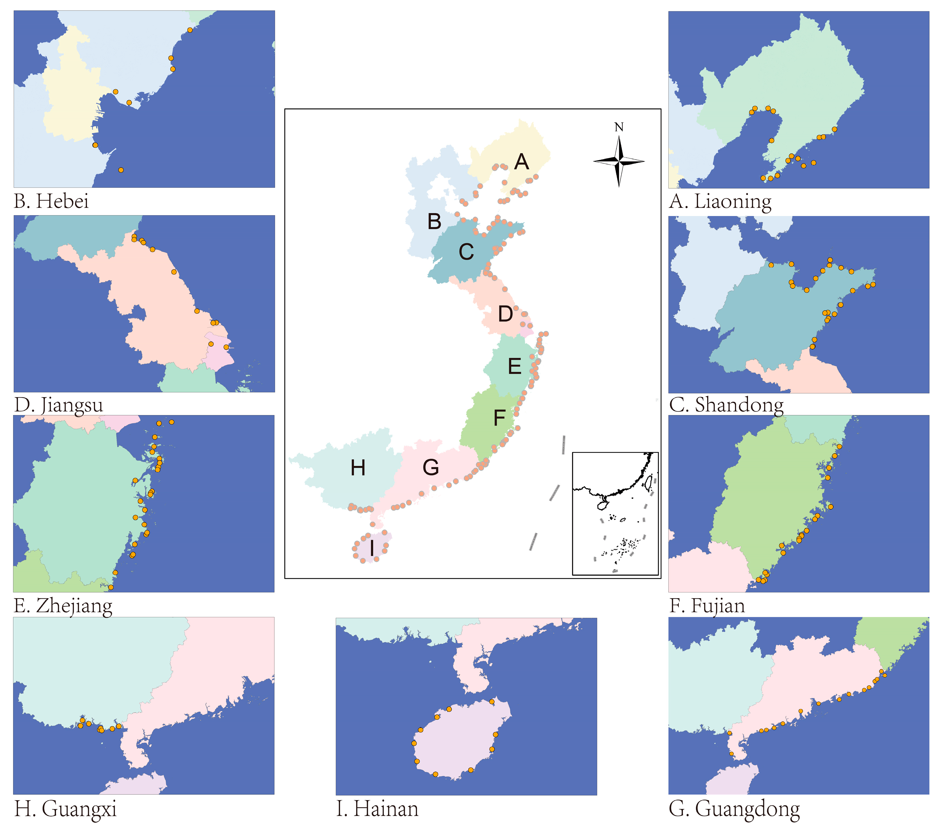
China’s coastline spans almost 50° latitude from north to south, covering a sea area of approximately 4.73 million km2, with a winding shoreline length of approximately 18,000 km and 7600 islands. Situated on the eastern side of the Asian–European continent, China faces the Pacific Ocean to the east, experiences alternating winter and summer monsoons, and has a notable monsoon climate in coastal regions. China boasts rich aquatic resources, with seas including the Bohai, Yellow, East China, and South China, along with four major sea areas and a total of 17 major fishing grounds in the region. Consequently, there are numerous fishing ports supporting marine fisheries, constituting basic traditional industries. Presently, China has almost 1300 fishing ports of varying sizes, categorized into central, first-, second-, third-class, and other fishing ports based on service scope, number of fishing vessels, and fish unloading volume. Among these, over 700 fishing ports are above the third level, with 144 identified as central and first-level fishing ports. Level 3 fishing ports only cater to small-scale county or city fishing boats with low throughput and atypical wind shelters. Therefore, central and first-level fishing ports were chosen as the most suitable research objects for this study. Moreover, owing to data acquisition limitations, accurately depicting the boundaries and locations of some fishing ports was challenging. Consequently, for this study, the research sample was refined to 134 central and first-class fishing ports with identifiable clear boundaries and significant location characteristics (Figure 1).
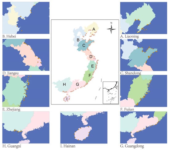
Figure 1.
Coastal fishing port distribution in China.
2.2. Data and Methods
2.2.1. Data Sources
This study employs satellite hyperspectral data with a 0.5 m spatial resolution, covering red, green, blue, and near-infrared multispectral bands. Data analysis was conducted based on multiple sources, including remotely sensed images from the coast of China spanning from 2020 to 2023, fishing port information collected from the National Coastal Fishing Port Construction Plan (2018–2025), land-use data acquired in 2020 from http://www.resdc.cn/data (accessed on 15 May 2023), coastal administrative division data, and boundary mapping, along with type analysis of China’s coastal fishing ports.
2.2.2. Graphical Generalization Method
In the 19th century, scientists proposed that graphs provide a completely new approach to handling complex data. This has primarily been applied in astronomy and terrestrial physics, where some concepts are introduced for generalization, and some are superimposed on observed facts [29]. The use of graphs makes the results of generalization more intuitive. In geography, RS provides an accurate record of the spatial evolution of geographic objects [30]. The process of overlaying RS-based images with existing concepts is called graphical generalization. In this study, we combined RS image maps of each port with port classes and land-use data to mark the vector boundaries and characteristics of fishing ports. Based on data availability and typicality, we selected RS images of central and first-class fishing ports spanning 11 coastal provinces in China collected in 2020 and screened 134 typical fishing ports with complete data for analysis. The primary steps taken to investigate port morphology and distribution using the graphical induction method were as follows: First, the ENVI 5.2 RS processing software was used to manually interpret the images that were combined with Google Earth Pro software. The vector boundaries of the fishing ports were mapped. The image data were subsequently imported into ArcGIS 10.8 software and combined with RS images of each port with land-use and administrative district data to determine the distribution of fishing ports and to correct their boundaries.
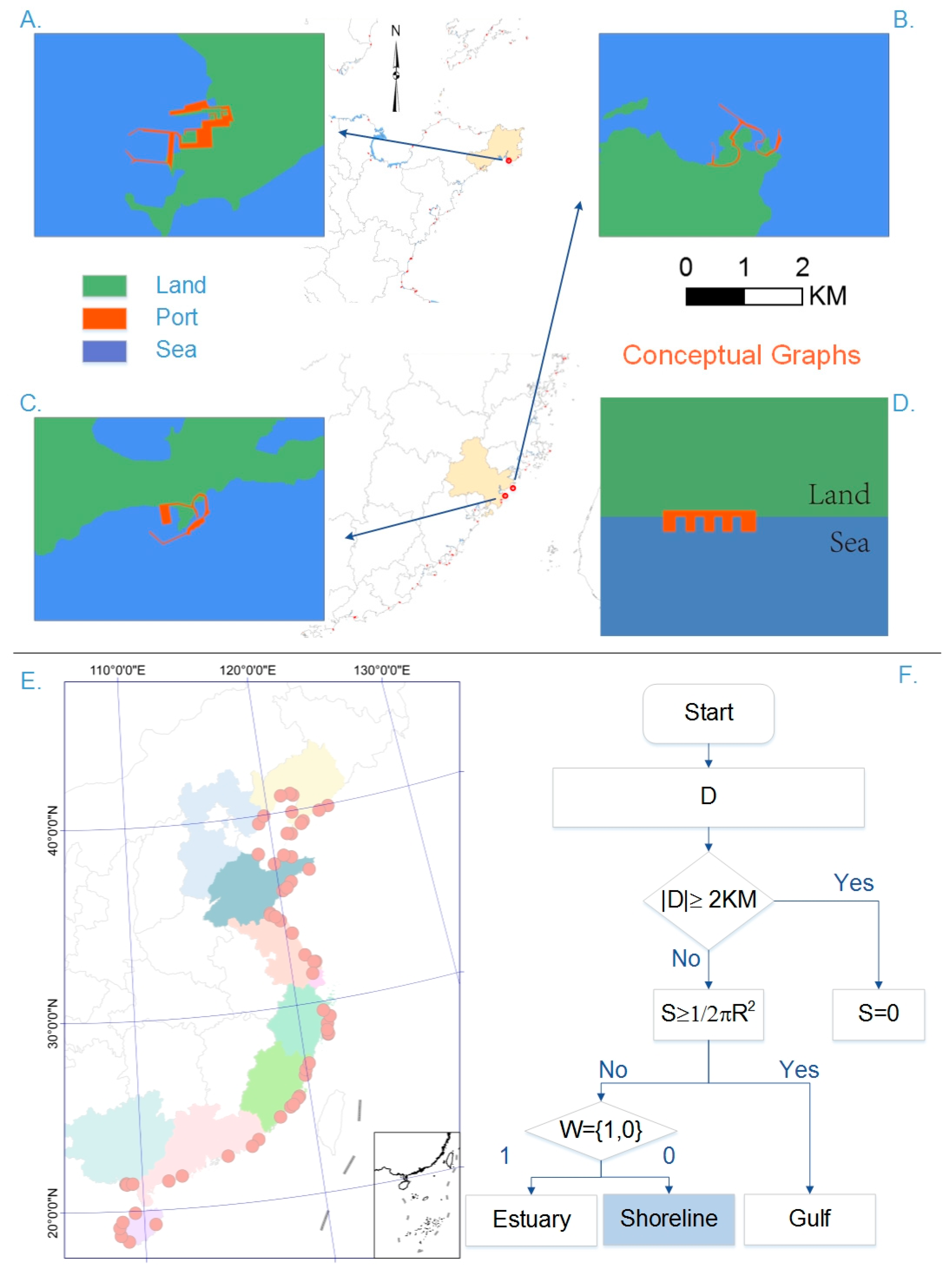
2.2.3. Decision Tree Classification
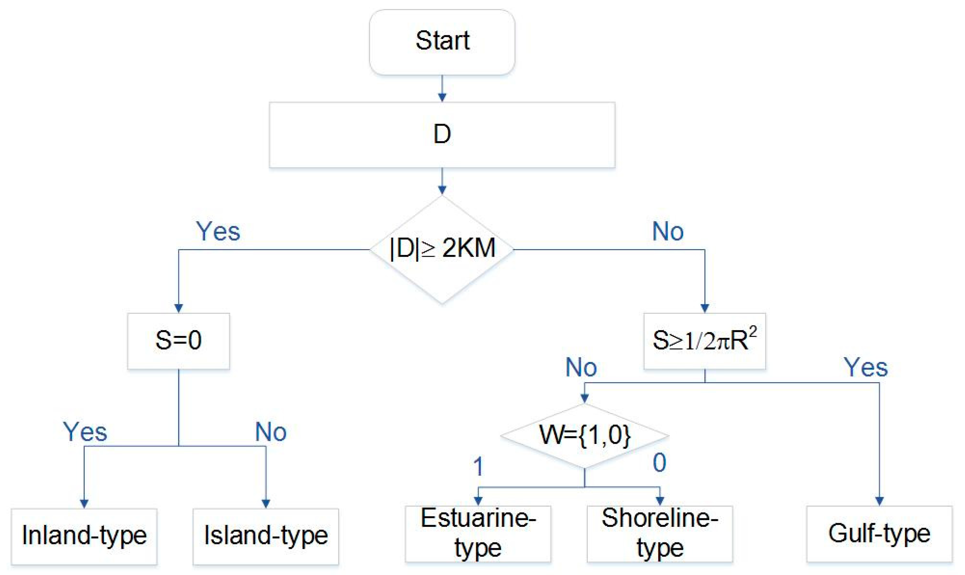
Decision trees (DTs), with their clear and interpretable classification structure, are an intuitively appealing method for data categorization [31]. Defined by a set of tests at each node, they recursively partition datasets into smaller subsets. This algorithm systematically divides data to establish decision tree branches (Figure 2). By assessing spatial features such as size, shape, and location and calculating the area near water bodies and the distance from the coastline, the characteristics of fishing port locations can be delineated. Using these spatial attributes, we develop classification rules and apply DT methodology to categorize fishing ports. The spatial characteristics of fishing ports include shoreline distance, hydrological conditions, and location. Here, D represents the distance from the fishing port to the shoreline, and S represents the water area where the ocean extends into the land; , R is the radius of the gulf while d is the diameter of the gulf mouth; W is the position of the fishing ports accompanied by a water system, W= {1, 0}. If W = 1, a water system converges into the ocean, and if W = 0, no water system exists.
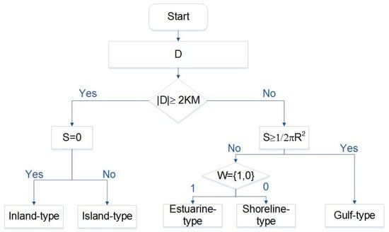
Figure 2.
Structure of a fishing port DT classification system.
In the classification method proposed in this study, a distance threshold must be set, which is determined through statistical analysis and continuous experimentation. The shortest distance from fishing port boundaries to the coastline was identified through visual interpretation. Using ArcGIS measurements, one group of fishing ports was found to be entirely inland, with the nearest Heiyanzi Fishing Port located 5.5 km from the coast. Most other ports were within 2 km of the shoreline. Thus, a 2 km distance was selected as the root node, with water area and hydrological conditions as intermediate nodes and port types as leaf nodes. The resulting DT, based on these criteria, is shown in Figure 2.
Ports are categorized by location into inland, estuary, and coastal types. Estuarine ports, which were China’s first ports, have deep-water channels for seafaring and inland navigation. Coastal ports leverage natural sandbar barriers, often avoiding the need for man-made breakwaters [32]. With economic expansion, the UN introduced dry ports in 1982 to alleviate transportation congestion [33]. Geographical location is key in port classification. Fishing ports, essential to the fishing industry, are typically located close to shore, influenced by the distribution of fishing zones and the perishable nature of seafood. Given that most are within 2 km of the coast, this distance serves as a classification criterion, with those beyond considered offshore. Distinct from container ports, fishing ports are also situated near fishing zones, especially around the Zhoushan Archipelago, leading to the classification of island-type fishing ports. Based on the DT analysis of fishing ports (Figure 2), RS images comprising coastal fishing ports and land use data were imported into the ArcGIS 10.8 software package. The intersection of these datasets was extracted through spatial superposition analysis to identify five types of coastal fishing ports. While a spatial distribution map of fishing ports can illustrate their spatial characteristics, this application is seldom seen in current research within this specific field. Utilizing spatial data obtained from ArcGIS, the DT was analyzed and summarized alongside location characteristics, establishing a fishing port type identification and spatial layout system. A spatial distribution map of fishing ports was generated using the comprehensive mapping and visualization functions of GIS. Statistical and retrieval functions were then employed to classify fishing ports based on their attributes and location characteristics. Fishing ports were divided into types based on their spatial location, distance from the shoreline, water area, and surroundings. Subsequently, a spatial classification identification system was formulated, and fishing port types were defined. Next, typical pairs of fishing ports were selected to analyze their differentiation and type characteristics. Finally, based on the typical scale and location of fishing ports, 15 representative samples were selected. A schematic of port location types was abstracted using the graphical induction method and DT to derive fishing port type characteristics and developmental laws. The process is illustrated in Figure 3.
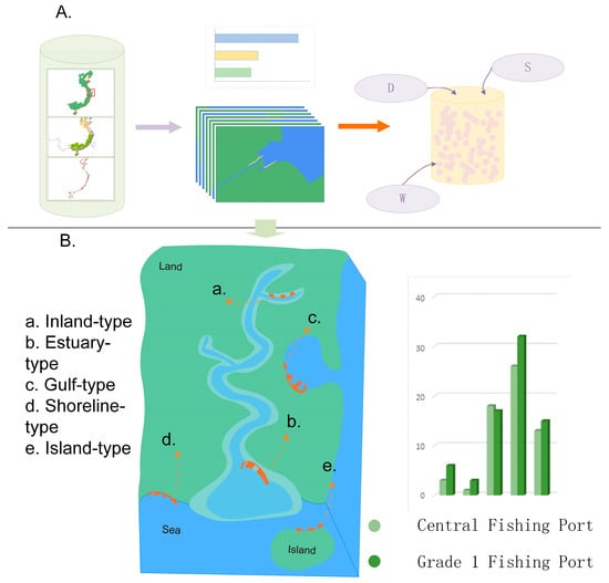
Figure 3.
Fishing port identification and classification flow chart. Part (A) section illustrates the data acquisition process: utilizing remote sensing (RS) processing software to extract fishing port imagery, delineate vector boundaries, overlay port grade data, and extract shoreline, water area, and hydrological condition data from the imagery. Part (B) shows the spatial distribution of classification results along the coastline and the quantitative characteristics of different grades of fishing ports for various types.
3. Results
In this study, a DT was first used to categorize fishing ports and then define and identify port types; subsequently, the spatial distribution of fishing port types in China is outlined. The spatial superposition method was utilized to identify fishing ports of different classes across all port types, and the results for each type are described in the following subsections.
3.1. Inland-Type Fishing Port Classification
In this study, fishing ports located inland, away from the shoreline, were categorized as inland-type ports. Images were imported into the proposed classification system for recognition processing. The distance from the port vector boundary to the shoreline was measured, and the presence of water surrounding the port was detected. A fishing port was recognized as an inland type when the distance from the port to the shoreline was greater than or equal to 2 km, and there was no water in the surrounding area, i.e., when D ≥ 2 km and S = 0.
The results identify nine inland-type fishing ports (Table 1). Spatial superposition analysis confirms that three of these are central, while six are classified as first-class fishing ports. Inland-type fishing ports consist of 33.33% central ports and 66.67% first-class ports, suggesting they comprise a minor share of large ports and are sparsely distributed nationwide. In this study, the central fishing ports of Heiyanzi (Figure 4A), Yangkou (Figure 4B), and Jiaojiang (Figure 4C) were sampled to investigate inland-type port characteristics (Figure 4D). Heiyanzi Fishing Port is located in Tangshan City, Hebei Province, and is a combination of fishing ports, albeit distributed on both sides of the river; it exhibits a striped pattern overall. Yangkou Center Fishing Port is located in Shouguang, Shandong Province, on the southern bank of Xiaoqing River and is shaped as a strip. Jiaojiang Center Fishing Port in Taizhou, Zhejiang, is built on the Jiaojiang River. The intertwined water systems near the fishing harbor provide convenient conditions for fishery production, processing, and trading activities. Inland-type fishing ports were predominantly strip-shaped. Some fishing ports consist of combined ports accompanied by water systems, while relatively few large-scale fishing ports exist.

Table 1.
Chinese inland-type fishing ports.
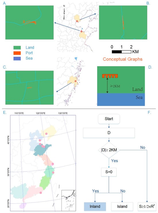
Figure 4.
Inland-type fishing port classification results. Figure (A–C) respectively show the boundary maps of Heiyanzi, Yangkou, and Jiaojiang fishing ports. Part (D) is a schematic diagram of the fishing port location. Part (E) illustrates the spatial distribution of inland ports in China. Part (F) is a partial schematic diagram of the DT classification process.
Most inland fishing ports are concentrated in the southern Bohai Sea, as well as in Jiangsu and Zhejiang Provinces. Bohai Bay, being an inland sea, experiences minimal influence from outer sea waves but is more susceptible to wind owing to its shallow water depths. This has a specific influence on the effectiveness of wind sheltering in fishing ports. Inland locations are characterized by their distance from the shoreline and are defined by the distribution of water systems. These areas exhibit special geographic features that affect the connectivity of ports along inland rivers and coastal regions. This often results in improved convenience for trade, processing, and transportation of both inland and marine aquatic resources. Additionally, it enhances the connectivity between land and sea. Therefore, fishing port developments along the riverbank at some distance from the shoreline ensure transportation convenience and reduce fishery production safety risks owing to natural disasters.
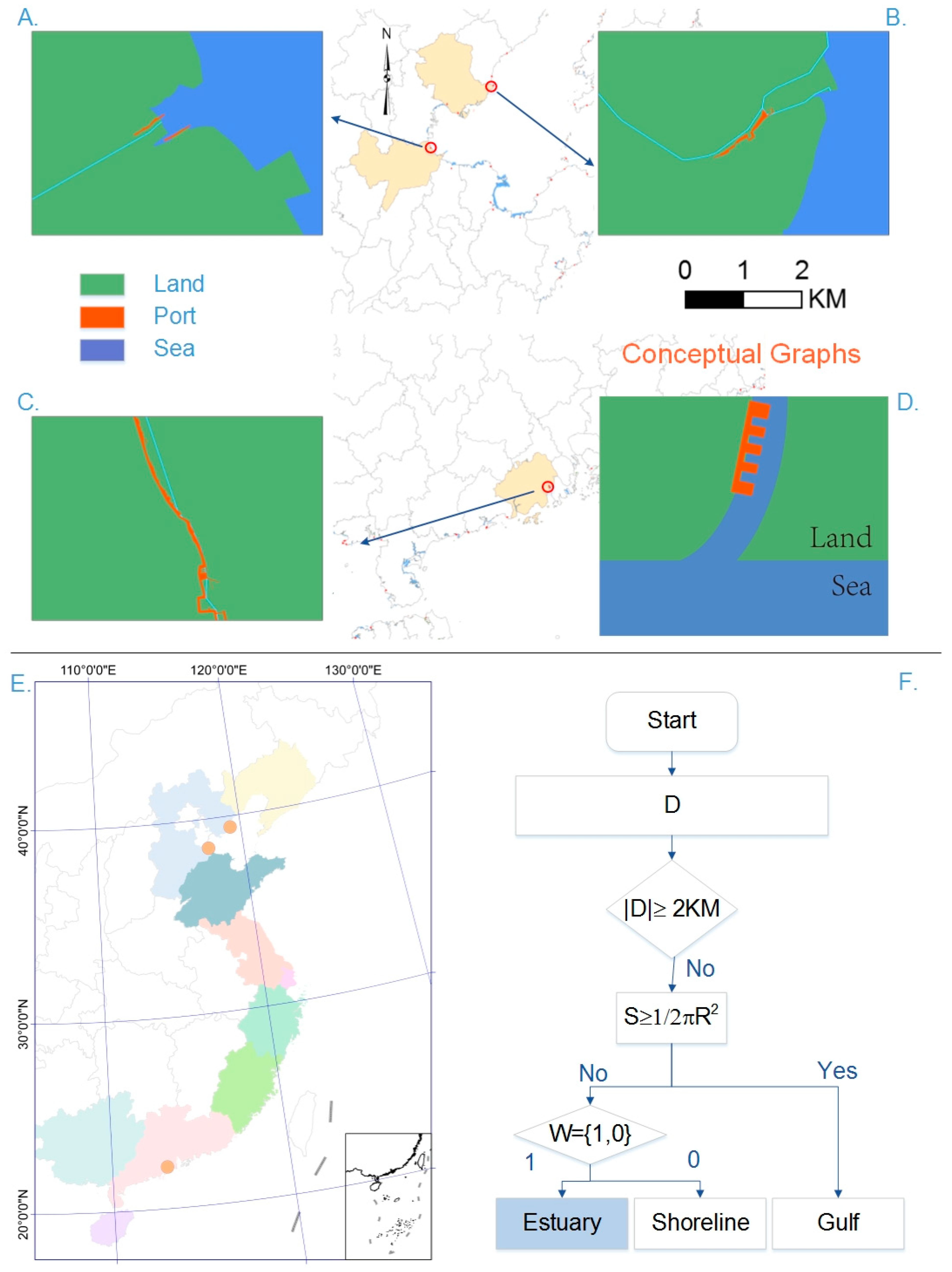
3.2. Estuarine-Type Fishing Port Classification
Fishing ports situated at the mouth or within the lower tidal boundary of a river were defined as estuarine-type fishing ports. RS images were input into the proposed classification system for analysis. Figure 5 illustrates that the distance from the port to the coastline is less than 2 km, and the ocean area extending into the land is less than the area of the semicircle with the diameter of the gulf mouth, accompanied by a water system. For example, if the geographic location is situated in the estuary, S < 1/2πR2, and W = 1, and if a water system in the sea exists, this is identified as an estuarine-type port (Figure 5D).
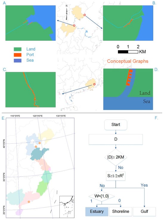
Figure 5.
Estuarine-type fishing port classification results. Figure (A–C) respectively show the boundary maps of Bohai Xincun, Laoting, and Yaimen fishing ports. Part (D) is a schematic diagram of the fishing port location. Part (E) illustrates the spatial distribution of estuarine-type ports in China. Part (F) is a partial schematic diagram of the DT classification process.
DT classification shows that estuarine-type fishing ports constitute a minor share of medium to large ports, with four in total: 25% are central ports, and 75% are first-class ports (Nanpaihe, Bohai Xincun (Figure 5A), Laoting (Figure 5B), and Yaimen (Figure 5C) are built in the water). Among these, the Nanpai and Bohai Xincun ports are located on the northern and southern banks of the Nanpai River, respectively, connecting to the Bohai Sea in the east. The marine fishery aquaculture and ship manufacturing industries have significantly contributed to economic growth in this region. Leiting Port is situated in the downstream section of the Luanhe River, which flows into the Bohai Sea and serves as the largest fishery wharf in Hebei Province. Yaimen Port, located in the Yinyu River basin, benefits from naturally formed wind-sheltered conditions, making it a longstanding and primary wind-shelter for local fishery production. Spatial superposition analysis indicates that only one estuarine port serves as a central fishing port in the scale hierarchy system, with relatively limited throughput and service scope. Generalized analysis results demonstrate that most estuarine ports are constructed in the form of strips aligned with the direction and shape of the water system, which is related to the natural wind-sheltered conditions of estuaries and river directions. Estuarine ports feature both offshore and deep-water channels, smooth water levels, and abundant biological resources provided by estuaries.
The results show that there are four estuarine-type ports (Table 2). From a distribution perspective, most estuarine ports are located in Hebei Province, and estuaries are where large rivers in the north converge into Bohai Bay. The waters are calm and rich in biological resources, providing potential for development and benefiting from natural wind-sheltered conditions. Convenient land and sea trade transportation further supports fishery development. Estuarine ports, situated at river mouths facing the sea, offer easy access for fishing boats and mooring. The convergence of river and seawater results in higher organic matter content, supporting abundant microorganisms and facilitating biodiversity formation. Consequently, aquatic resources are plentiful, facilitating the formation of fishing grounds. Estuarine ports typically feature offshore deep-water channels and facilitate berthing and communication with inland waterways for loading, unloading, and operational activities. This is complemented by favorable geographical locations and stable shorelines, which form a natural wind barrier, ensuring convenient land and water transportation, as well as operational safety.
Table 2.
Chinese estuarine-type fishing ports.
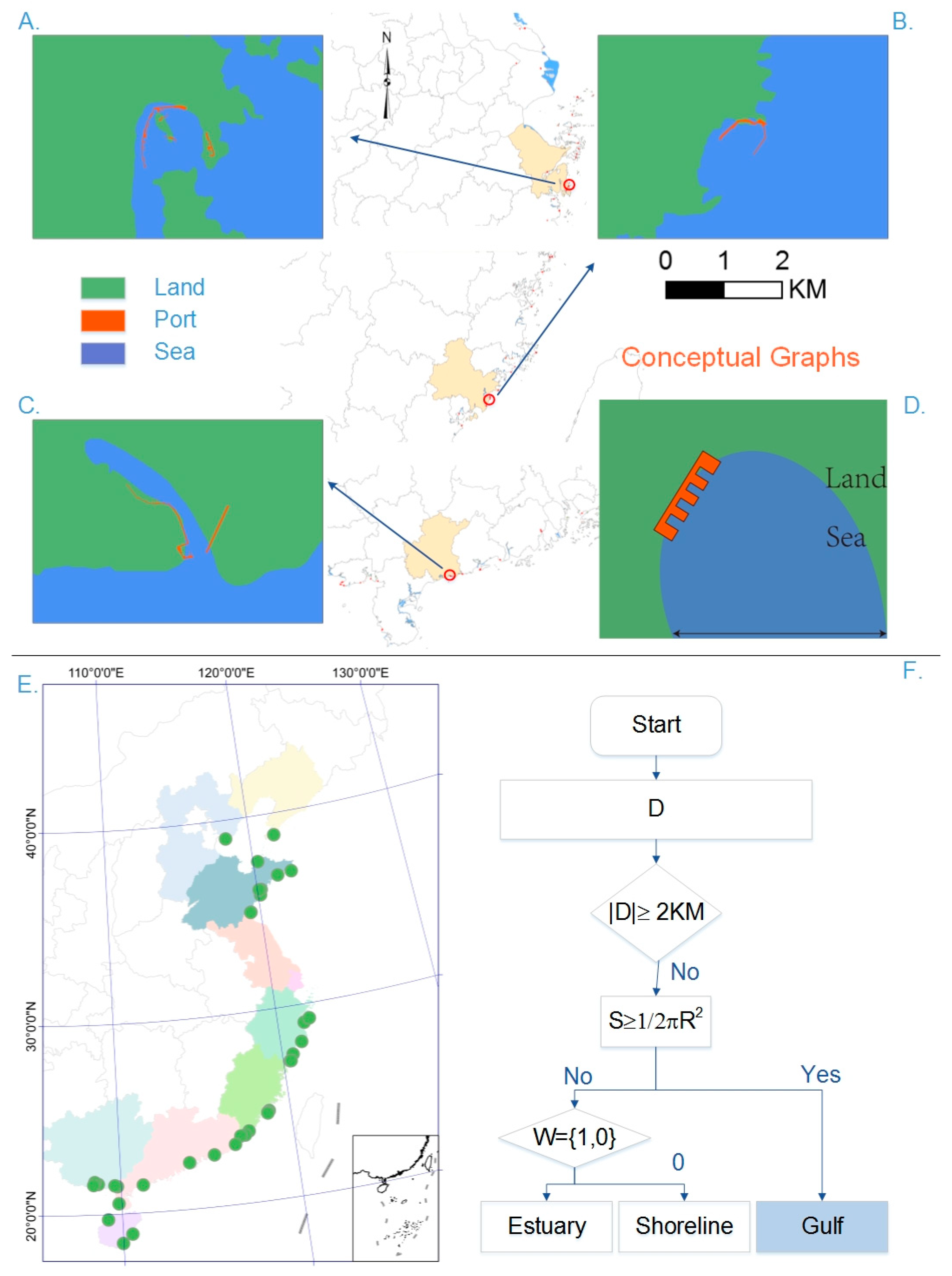
3.3. Gulf-Type Fishing Port Classification
Fishing ports situated in sea areas with pronounced water curvature and surrounded by land, meeting the definition of a gulf according to international law, were categorized as gulf-type fishing ports. According to international law, an ocean area extending into land that is greater than or equal to the area of a semicircle with the diameter of the gulf mouth is defined as a gulf. Hence, RS images were imported into the proposed classification system to identify and analyze gulf-type fishing ports. Herein, when S ≥ 1/2πR2, the water area was defined as a gulf, and fishing ports in this region were identified as gulf-type (Figure 6D).
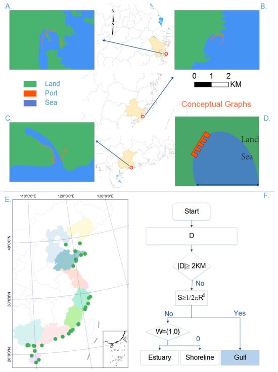
Figure 6.
Gulf-type fishing port classification results. Figure (A–C) respectively show the boundary maps of Shipu, Dongpu, and Boga fishing ports. Part (D) is a schematic diagram of the fishing port location. Part (E) illustrates the spatial distribution of gulf-type ports in China. Part (F) is a partial schematic diagram of the DT classification process.
The results showed that there are 35 gulf-type ports (Table 3), constituting the second most widely distributed fishing ports in China. More than 50% are major central fishing ports with a wide range of services and a high level of fishing vessel ownership. Among them, 51.43% are central fishing ports, and 48.57% are first-class fishing ports. These ports include Shipu (Figure 6A), situated in Ningbo City, Zhejiang Province, which boasts a long fishing history and is one of the four major mass ports in China. The primary morphology of the fishing port follows a “U” distribution along the shoreline, characterized by smooth winds and waves. Estuarine ports have wide berths and good mooring conditions. Dongpu Port (Figure 6B) is located in Shishi City, Fujian Province, and also consists of a U-shaped distribution, echoing the mouth of the gulf to reduce wind and wave disturbances. Boga Port (Figure 6C) is located in Maoming City, Guangdong Province, and is characterized by a narrow gulf mouth and a large seawater area extending deep into the land. The fishing port is divided into two areas on the east and west sides of the gulf, with elongated and narrow port pools providing favorable conditions for fishing vessel docking. The results indicate that gulf-type fishing ports are predominantly U-shaped and constructed along the curve of the gulf shoreline. Owing to the action of seawater, the gulf naturally forms a narrow waterway for ships to berth and traverse, providing favorable wind conditions that ensure production and operational safety. The gulf-type port benefits from coastal wind conditions in conjunction with the U-shaped design, which enhances wind prevention and reduces the impact of natural disasters.
Table 3.
Chinese gulf-type fishing ports.
From a spatial distribution perspective, gulf-type fishing ports are distributed across all provinces except in Jiangsu, with clustering emphasized in the south. This is primarily attributed to the geological characteristics of the coastline in Jiangsu Province. Gulf-type ports naturally provide shelter and effectively avoid the impact of wind and waves, making them suitable for silt-sandy coastlines where sediment continues to accumulate, resulting in the expansion of mudflat areas. In contrast, Jiangsu Province lacks natural shelter conditions, making it unsuitable for fishing port developments with high wind protection demands. The southern region, spanning from Guangxi to Hainan and the Zhejiang coastal areas, is most affected by typhoons. These areas rely on the U-shaped shoreline characteristics of the gulf, which produce a buffer effect on wind and waves, allowing fishing boats to safely navigate difficult conditions and reducing fishery losses due to natural disasters. Owing to its proximity to the coast and sea, the gulf has open waters at the mouth simplifying the development of marine pastures, with narrow waterways at the interior facilitating land and sea cooperation. These conditions provide wind barriers, gentle currents, and channels conducive to docking and shipbuilding activities, as well as the development of trade and logistics, high-efficiency aquaculture, coastal tourism, offshore fishing, and other comprehensive services.
3.4. Shoreline-Type Fishing Port Classification
Fishing ports situated on straight and level shorelines were classified as shoreline types. Ports located less than 2 km from a straight shoreline without a gulf mouth or river confluence (i.e., ports that satisfy D < 2 km, S < 1/2πR2, and W = 0) were identified as shoreline types (Figure 7D).
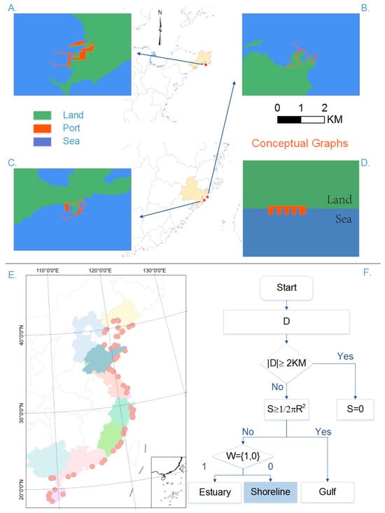
Figure 7.
Shoreline-type fishing port classification results. Figure (A–C) respectively show the boundary maps of Shawo Island, Xiangzhi, and Chongwu fishing ports. Part (D) is a schematic diagram of the fishing port location. Part (E) illustrates the spatial distribution of shoreline -type ports in China. Part (F) is a partial schematic diagram of the DT classification process.
The shoreline port types are summarized as follows. Shawo Island Port (Figure 7A), located in Rongcheng, Shandong Province, serves as a national offshore fishing base with multiple zigzags in its port pool and exhibits shoreline morphology. It accommodates a significant number of berths. Xiangzhi (Figure 7B) is the first large-scale centralized fishing port in Fujian Province. The fishing ports are strategically constructed in alignment with shoreline conditions, with the port morphology designed to accommodate the zigzagging nature of the shoreline. An artificial windbreak dike was constructed based on natural shoreline conditions to enhance production security. The port area is relatively open owing to gentle hydrological conditions. Chongwu Central Port (Figure 7C), located in Fuzhou, Fujian Province, is surrounded by the sea on three sides. The curvature of the port is larger, allowing windbreak dikes to be built to address limited windbreak conditions along the shoreline. It was observed that the curvature degree of the shoreline port type is larger, and a windproof dike is constructed to resist the impact of wind and waves.
The results show that the shoreline is the most dominant fishing port type, with 58 such ports in China. Within this group, 44.83% are central ports, and 55.17% are first-class ports.
Shoreline ports are distributed across all coastal areas. The spatial superposition analysis identified 26 central ports (Table 4), with the remainder classified as first-class. Shoreline fishing ports provide multiple processing and trading platforms for fishery production and are distributed throughout the country in areas with fewer wind and wave disturbances and straighter shorelines. Owing to the influence of the Asian monsoon system in China, summer winds in the eastern coastal areas are southeasterly, while winter winds are northwesterly. Therefore, most shoreline-type fishing ports are distributed over large gulfs and inland seas, such as in the Yellow Bohai Sea, Taiwan Straits, and the Gulf of Tonkin. These areas experience low wind or wave fluctuation, and the water has a gentle current, making them more suitable for fishing port construction and providing a natural barrier for safe fishery production. Although typhoons are expected to occur, this region is rich in aquatic and biological resources, similar to China’s major fishing areas, and open waters are available with favorable conditions for fisheries development.
Table 4.
Chinese shoreline-type fishing ports.
3.5. Island-Type Fishing Port Classification
Fishing ports located on islands more than 2 km from the mainland shoreline and surrounded by water were defined as island-type fishing ports. This is expressed as |D| ≥ 2 km in the proposed classification system, and S ≠ 0 is identified as an island type (Figure 8D).
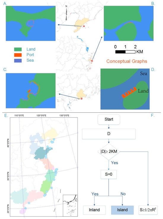
Figure 8.
Island-type fishing port classification results. Figure (A–C) respectively show the boundary maps of Four Stone, Shenjiamen, and Zhapo fishing ports. Part (D) is a schematic diagram of the fishing port location. Part (E) illustrates the spatial distribution of island -type ports in China. Part (F) is a partial schematic diagram of the DT classification process.
Island-type ports include the Four Stone fishing ports (Figure 8A) on Changshan Island in Dalian, Liaoning Province, which are built around the coastline and across from Changxing Island. This group of fishing ports has a ring-shaped port morphology. Shenjiamen (Figure 8B) is the largest natural fishing port in China and the third-largest worldwide. It is located on the southern tip of Zhoushan Island in Zhejiang Province, with mountain ranges behind it and is a good natural port for wind shelter. Zhapo (Figure 8C), situated on Hailing Island in Guangdong Province, is among the initial group of Chinese national central fishing ports. It is designed to resemble a half-ring shoreline. It has superior wind shelter and supply conditions. The results revealed that the majority of island-type fishing ports are situated in archipelagos, and most of these ports were primarily developed as natural fishing ports, capitalizing on the natural wind-sheltering conditions provided by the shoreline. Consequently, the shape of the fishing ports fundamentally aligns with that of the shoreline.
Most island-type ports are distributed in a network structure in line with the distribution characteristics of Chinese archipelagos. The results indicate that island-type fishing ports are the third-largest port type, with 28 ports distributed nationwide (Table 5). According to the spatial superposition analysis, almost 50% are central fishing ports. The clustering phenomenon of island-type fishing ports is most prominent, predominantly concentrated in the Changshan and Zhoushan Islands. A typical characteristic of these fishing harbors is their proximity to archipelagos and their location at the intersection of warm and cold currents, where the churning action of the sea causes organic matter to rise, conducive to the growth and reproduction of biological resources. These archipelagos are also the areas where China’s large fishing grounds are located. Additionally, the archipelago’s presence has an inhibitory effect on wind and wave disturbances, guaranteeing operational safety for fishing ports. Another characteristic of such fishing ports is regional agglomeration. The current development mode of China’s island resources has shifted from single-island to archipelago development, forming clusters of fishing ports and improving operational efficiency for fishing ports.
Table 5.
Chinese island-type fishing ports.
4. Discussion
Fisheries represent an important source of income for many coastal towns worldwide [34]. Additionally, fishing ports serve as platforms for the economic, social, and ecological management of fisheries. China, as the largest developing country and fish producer, prioritizes sustainable economic development, livelihood protection, and modernizing fishery management in its fishing port construction. Therefore, new fishing ports must be capable of managing the impact of natural disasters, and integrating fishery production, processing, trade, and logistics is crucial for advancing this industry. In this study, a fishing port type DT classification system was proposed to classify China’s coastal fishing ports into five specific categories: inland, estuarine, gulf, shoreline, and island types. This classification was based on investigating and classifying the spatial characteristics of each port. The results revealed that Chinese fishing port types are predominantly related to natural resource distribution, climatic characteristics, and wind and wave conditions, which align with traditional fishing port requirements and functions. Additionally, the study showed that port morphology and distribution correlate with fishing port types, with fishing port construction considering transportation and production safety. This study confirmed that the spatial division of fishing ports can clarify the advantages and disadvantages of their locations and production demand tendencies, providing guidance for selecting the most appropriate management style. Furthermore, it offers a unique perspective on the spatial differentiation and agglomeration of fishing ports. Fishing port development and coastal zone management are closely linked, with port and township construction centered on the coastal zone, promoting economic development and exploiting natural resources. However, irrational development can damage the coastal environment, contradicting sustainable development goals. Therefore, effective fishing port classification and clarification of functions can contribute to conducting coastal zone planning, management, and governance. Depending on fishing port types, more specialized and personalized services can be provided to fishermen and breeders, thereby improving fishery production efficiency and management. The port sector is currently expanding its geographical scope of activities, developing across port nodes, promoting joint development with overseas and neighboring ports, constructing port clusters, and establishing a port network—a major trend in development. The port cluster trend aims to reduce port homogenization, transform intense port competition into a mutually beneficial port cluster development drive, and improve port infrastructure, service functions, and economic and social development, supporting the adjustment of the industrial structure.
Research on port competitiveness reveals that a port’s advantages hinge on its location and situation relative to other ports and shipping routes [35]. Analyzing the spatial features of fishing ports clarifies their geographic benefits and positioning, boosting their competitiveness and efficiency. This study finds that most Chinese fishing ports are built close to shorelines, bays, and islands, reflecting early considerations of natural and sheltered conditions against rough seas. Among the classified port types, bay and shoreline ports are most prevalent, with island ports following, highlighting the importance of biological richness, safety, and operational efficiency in port siting. Existing studies that focus on the classification of port types have assessed the competitiveness of China’s major fishing ports from a port-cluster perspective. These studies have identified each port type using an improved Boston matrix model, revealing the relationship between cooperation and competition in the port integration process [36]. Other studies have classified large ports and recreational terminals, focusing on the human influence on port environments [37]. Furthermore, studies have enhanced port management efficiency by simplifying the port classification system and defining ports as primary, secondary, or tertiary [38]. Examining the distinctions between fishing port types can mitigate competitive homogeneity, fostering port-cluster collaboration. This can enhance port infrastructure and services, thereby bolstering socio-economic progress and industrial restructuring in fishing regions.
Existing research primarily focuses on the role, capacity, cargo type, and volume of fishing ports. According to the results of these previous studies, fishing ports serve for fishery production and processing and, therefore, have higher requirements for natural conditions than container ports. This study differs in that it classifies fishing port types along the Chinese coast by focusing on their spatial characteristics. Spatial classification methods provide a more integrated approach to spatial management, enhancing coordination and facilitating objective comparisons across local to international scales. This method supports FAO’s promotion of aquaculture by strategically allocating space through the designation of aquaculture zones (AZA), which helps to minimize spatial conflicts and environmental and socio-economic impacts [39]. Coastal classification and mapping are instrumental in marine spatial management, aiding in biodiversity conservation, fisheries management, and the development of a sustainable blue economy. The classification of imagery from RS is also a key method for spatial planning, allowing for the extraction of clear geographical features of fishing ports, which is beneficial for further assessment of the ports’ resources, risks, and potential [40].
Economists have previously developed fisheries with economic potential for sustainable fishing port development [41] and have achieved fishery management goals with a combination of biological, economic, social, and political objectives [42,43].
According to Brid’s Anyport model, the evolution of ports over time can be divided into three stages: formation, expansion, and specialization. Based on the evolution of the law of fishing ports and the development of current marine fisheries, China has entered the specialization stage. Scientific management of fishing ports helps improve production service capacity. Fishing ports are currently in the developing stage, and rather than the expansion or construction of new ports, improving the relationship between ports and the surrounding environment is necessary. Historically, ports have been closely linked to cities in a symbiotic manner, providing food and urban products. Fishing ports that continue to retain their traditional production and processing functions have an extremely close relationship with urban development. The integration of ports and cities is important for sustainable port development [44], and it has been confirmed that ports and cities are frequently viewed as clusters with shared values, a concept that makes port development and cities tightly intertwined [45]. The nature of employment and economic structures linking fishing port development with urban and rural areas maximizes economic benefits and integration. Classifying fishing port spatial characteristics benefits coastal protection and sustainable development. The use of GIS and machine learning for geospatial analysis helps to assess and direct fishing port development, enhancing the fishing economy’s sustainability. UNESCO’s “Ocean Decade” [46] initiative aims to bolster coastal resilience, including through global estuary monitoring and marine city networks, which require multi-stakeholder collaboration.
In China, fishing port development is a joint effort among fishermen, businesses, and the government, with spatial differences influencing regional marine development. Scientific classification of port features allows for a comprehensive understanding of geographical advantages, minimizing ecological impact and guiding the construction of efficient, secure modern fishing ports. This approach fosters sustainable fishing industry growth and high-quality economic development.
Fishing port typology must delineate the different morphological and functional characteristics present in various economic, social, and natural contexts. Future integration of fishing port spatial classifications with socio-economic data will deepen our understanding of coastal ecosystems and support socio-economic development, enabling better management of port diversity and sustainable development goals.
As with any study, potential limitations should be acknowledged. One limitation of this study is the current lack of data availability on the amount of cargo loaded and unloaded, as well as the production level in fishing ports. The size of fishing ports is small, their economic radiation is limited, and the infrastructure development and natural resources for each fishing port differ. One future research direction is the development of fishing port clusters, which has clear potential to reduce the cost of future advancement.
5. Conclusions
This study proposes a classification system based on the identification of spatial distribution characteristics to define fishing port types from a new perspective. The study depicts the vector margins of RS images of fishing ports in China’s coastal provinces, analyzes the spatial superposition of fishing port boundaries utilizing land-use data, and classifies fishing port types based on the distance from the shoreline, water area, and surrounding water. The results show that coastal fishing ports can be divided into five categories: inland, estuarine, gulf, shoreline, and island types. A new classification system is proposed based on the spatial distribution characteristics of fishing ports.
Ports with a distance of over 2 km from the shoreline were identified as inland, those less than 2 km in distance and located at a river mouth were identified as estuarine, and those located at the flat shoreline or in the curved water area and in gulfs surrounded by land were identified as gulf types. Fishing ports located at the straight shoreline were classified as shoreline types, and those located at the principal shoreline and independent islands were classified as island types. In this study, a graphical induction method was used to classify 134 first-class and above fishing ports along the coast of China. Shoreline and gulf-type fishing ports are the most widely distributed in China. The results demonstrate that shoreline and gulf types account for 43% and 26% of the total number of fishing ports, respectively. Shoreline-type fishing ports have many zigzags in the harbor pools to build artificial wind barriers, while gulf-type fishing ports are mostly in the form of a “U” shape; both were built in accordance with the shape of the coastline. Inland-type and estuarine-type fishing ports are mostly in the form of a strip, and most of them were built according to the rivers. Island-type fishing ports are built on island groups, and their morphology is mostly consistent with the island coastline.
By comparing the characteristics of each port type, the type of port can be concluded to be related to natural resources, climatic conditions, geographic location, and distribution of water systems in the region, which directly affect the location preference of fishing ports and functions. Therefore, the development and management of fishing ports should be analyzed from a combination of resource-, labor-, and market-directed perspectives. Furthermore, attention should focus on areas where natural and labor resources are concentrated, and fishing port management style and modernization should be comprehensively formulated according to the natural regional conditions and socio-economic development of the hinterland.
Further investigation regarding the relationship between port clusters and towns using information such as GDP output, distance thresholds, and product categories will be a focal point of future research.
Author Contributions
Conceptualization, Z.L. and W.L.; methodology, Z.L.; software, Z.S.; validation, G.C. and Z.S.; formal analysis, Z.L.; investigation, Z.L.; resources, C.T.; data curation, G.C.; writing—original draft preparation, Z.L.; writing—review and editing, W.L.; visualization, Z.S.; supervision, C.T.; project administration, W.L.; funding acquisition, W.L. All authors have read and agreed to the published version of the manuscript.
Funding
This research was funded by the Key Project of the National Natural Science Foundation of China (No. 42030409).
Data Availability Statement
The raw data supporting the conclusions of this article will be made available by the authors upon request.
Acknowledgments
We thank our colleagues at DLMU for constructive discussions and insights, especially the helpful contributions from Weixin Luan and Zun L.
Conflicts of Interest
The authors declare no conflicts of interest.
References
- Towards Blue Transformation. Available online: https://www.fao.org/state-of-fisheries-aquaculture/en/ (accessed on 10 May 2024).
- Su, S.; Tang, Y.; Chang, B.; Zhu, W.; Chen, Y. Evolution of marine fisheries management in China from 1949 to 2019: How did China get here and where does China go next? Fish Fish. 2020, 21, 435–452. [Google Scholar] [CrossRef]
- Fabinyi, M.; Liu, N. The Chinese policy and governance context for global fisheries. Ocean Coast. Manag. 2014, 96, 198–202. [Google Scholar] [CrossRef]
- The State of World Fisheries and Aquaculture 2022. Available online: https://www.fao.org/3/cc0461en/online/cc0461en.html (accessed on 10 May 2024).
- Adenso-Díaz, B.Á.N.G. A fuzzy AHP classification of container terminals. Marit. Econ. Logist. 2020, 22, 218–238. [Google Scholar] [CrossRef]
- Sahu, P.; Sharma, S.; Patil, G.R. Classification of Indian seaports using hierarchical grouping method. J. Marit. Res. 2014, 11, 51–57. [Google Scholar]
- MODULE 3 Alternative Port Management Structures and Ownership Models: Port Functions, Services, and Administration Models. Available online: https://www.ppiaf.org/sites/ppiaf.org/files/documents/toolkits/Portoolkit/Toolkit/module3/port_functions.html (accessed on 10 May 2024).
- Bichou, K.; Gray, R. A critical review of conventional terminology for classifying seaports. Transp. Res. Part A Policy Pract. 2005, 39, 75–92. [Google Scholar] [CrossRef]
- Pérez, I.; González, M.M.; Trujillo, L. Do specialisation and port size affect port efficiency? Evidence from cargo handling service in Spanish ports. Transp. Res. Part A Policy Pract. 2020, 138, 234–249. [Google Scholar] [CrossRef]
- Xu, Q.; Huang, T.; Chen, J.; Wan, Z.; Qin, Q.; Song, L. Port rank-size rule evolution: Case study of Chinese coastal ports. Ocean Coast. Manag. 2021, 211, 105803. [Google Scholar] [CrossRef]
- Nanyam, V.P.S.N.; Kumar Jha, N. Modeling challenges affecting the performance of major ports of India. Asian J. Shipp. Logist. 2023, 39, 26–38. [Google Scholar] [CrossRef]
- Putri; Eka, A.; Boesono, H.; Wijayanto, D. The strategies of Pekalongan fishing port development, Indonesia. IOP Conf. Ser. Earth Environ. Sci. 2020, 530, 12032. [Google Scholar] [CrossRef]
- Curtin, R.; Mccullough, N. The socioeconomic impact of the seafood sector at Ireland’s main ports. Mar. Policy 2023, 152, 105627. [Google Scholar] [CrossRef]
- Meeanan, C.; Noranarttragoon, P.; Sinanun, P.; Takahashi, Y.; Kaewnern, M.; Matsuishi, T.F. Estimation of the spatiotemporal distribution of fish and fishing grounds from surveillance information using machine learning: The case of short mackerel (Rastrelliger brachysoma) in the Andaman Sea, Thailand. Reg. Stud. Mar. Sci. 2023, 62, 102914. [Google Scholar] [CrossRef]
- Speir, C.; Pomeroy, C.; Sutinen, J.G. Port level fishing dynamics: Assessing changes in the distribution of fishing activity over time. Mar. Policy 2014, 46, 171–191. [Google Scholar] [CrossRef]
- Gómez, S.; Maynou, F. Economic, sociocultural and ecological dimensions of fishing capacity in NW Mediterranean fisheries. Ocean Coast. Manag. 2020, 197, 105323. [Google Scholar] [CrossRef]
- Darasi, F.; Aksissou, M. Longline, trawl, and purse seine in coastal fishing of Tangier port in North-West of Morocco. Egypt. J. Aquat. Res. 2019, 45, 381–388. [Google Scholar] [CrossRef]
- Bugeja Said, A.; Guyader, O.; Frangoudes, K. Diagnosing ‘access’ matters in the governance of moored fishing aggregate devices (MFADs): A perspective for SDG14b from Malta and Guadeloupe. Ocean Coast. Manag. 2021, 214, 105890. [Google Scholar] [CrossRef]
- Phelan, K.; Gardner, A.; Selig, E.R.; Sparks, J.L.D. Towards a model of port-based resilience against fisher labour exploitation. Mar. Policy 2022, 142, 105108. [Google Scholar] [CrossRef]
- Doumbouya, A.; Camara, O.T.; Mamie, J.; Intchama, J.F.; Jarra, A.; Ceesay, S.; Guèye, A.; Ndiaye, D.; Beibou, E.; Padilla, A.; et al. Assessing the Effectiveness of Monitoring Control and Surveillance of Illegal Fishing: The Case of West Africa. Front. Mar. Sci. 2017, 4, 242388. [Google Scholar] [CrossRef]
- Sciutteri, V.; Pedà, C.; Longo, F.; Calogero, R.; Cangemi, G.; Pagano, L.; Battaglia, P.; Nannini, M.; Romeo, T.; Consoli, P. Integrated approach for marine litter pollution assessment in the southern Tyrrhenian Sea: Information from bottom-trawl fishing and plastic ingestion in deep-sea fish. Mar. Pollut. Bull. 2023, 188, 114661. [Google Scholar] [CrossRef]
- Onden, I.; Samasti, M.; Canci, M.; Eldemir, F.; Aktel, A. Evaluation and Categorization of the Fishing Ports with a Fuzzy Spatial Multi Criteria Approach: The Case of Turkey. Turk. J. Fish. Aquat. Sci. 2017, 17, 499–508. [Google Scholar] [CrossRef]
- Hiranandani, V. Sustainable development in seaports: A multi-case study. WMU J. Marit. Aff. 2014, 13, 127–172. [Google Scholar] [CrossRef]
- Dishington, R. Towards a historical geography of marine engineering: D. & T. Stevenson, Wick harbour and the management of nature. J. Hist. Geogr. 2020, 69, 80–90. [Google Scholar] [CrossRef]
- Uda, T.; Onaka, S.; Serizawa, M. Beach Erosion Downcoast of Pengambengan Fishing port in Western Part of Bali Island. Procedia Eng. 2015, 116, 494–501. [Google Scholar] [CrossRef]
- Ozturk, D.; Maras, E.E. Investigation of the effects of small fishing ports on the shoreline: A case study of Samsun, Turkey. J. Coast. Conserv. 2024, 28, 20. [Google Scholar] [CrossRef]
- Sharaan, M.; Iskander, M.; Nadaoka, K.; Negm, A.; Ibrahim, M.G. Learned Lessons from Japanese Experiences in Planning and Managing Fishing Ports. In Sustainable Development of Water and Environment; Springer: Cham, Switzerland, 2023; pp. 55–65. [Google Scholar]
- Mou, N.; Wang, C.; Chen, J.; Yang, T.; Zhang, L.; Liao, M. Spatial pattern of location advantages of ports along the Maritime Silk Road. J. Geogr. Sci. 2021, 31, 149–176. [Google Scholar] [CrossRef]
- Hankins, T.L. A “Large and Graceful Sinuosity”: John Herschel’s Graphical Method. Isis 2006, 97, 605–633. [Google Scholar] [CrossRef]
- Li, Z.; Luan, W.; Wang, X.; Wan, S.; Su, M.; Zhang, Z. Spatial expansion regular pattern and driving factors of estuarine and coastal harbors. Ocean Coast. Manag. 2022, 216, 105980. [Google Scholar] [CrossRef]
- Friedl, M.A.; Brodley, C.E. Decision tree classification of land cover from remotely sensed data. Remote Sens. Environ. 1997, 61, 399–409. [Google Scholar] [CrossRef]
- Aguirre, J.D.; Bollard-Breen, B.; Cameron, M.; Constantine, R.; Duffy, C.A.J.; Dunphy, B.; Hart, K.; Hewitt, J.E.; Jarvis, R.M.; Jeffs, A.; et al. Loved to pieces: Toward the sustainable management of the Waitematā Harbour and Hauraki Gulf. Reg. Stud. Mar. Sci. 2016, 8, 220–233. [Google Scholar] [CrossRef]
- Zheng, M.; Lian, F.; Yang, Z. Study on the transport advantage and optimal port scale of a Bay Area. Ocean Coast. Manag. 2022, 219, 106056. [Google Scholar] [CrossRef]
- Torres Cañete, F.; Oyanedel, R.; Gelcich, S. Adoption and impacts of fishing gear innovations: Insights from a small-scale fishery in Chile. Fish. Res. 2022, 248, 106200. [Google Scholar] [CrossRef]
- Mccalla, R.J. Container transshipment at Kingston, Jamaica. J. Transp. Geogr. 2008, 16, 182–190. [Google Scholar] [CrossRef]
- Xiao, R.; Liu, S.; Wu, L.; Luo, M.; Ma, R.; Li, J. Regional classification and competitiveness of port cluster: A case study of China’s coastal ports. Int. J. Logist. Res. Appl. 2023, 1–18. [Google Scholar] [CrossRef]
- Tempesti, J.; Langeneck, J.; Romani, L.; Garrido, M.; Lardicci, C.; Maltagliati, F.; Castelli, A. Harbour type and use destination shape fouling community and non-indigenous species assemblage: A study of three northern Tyrrhenian port systems (Mediterranean Sea). Mar. Pollut. Bull. 2022, 174, 113191. [Google Scholar] [CrossRef]
- Othman, M.K.; Abdul Rahman, N.S.F.; Ismail, A.; Osnin, N.A.; Hanafiah, R.M. Revisiting Malaysia’s port classification system in a complex operational environment to streamline the coordination and management of maritime ports. Case Stud. Transp. Policy 2023, 13, 101062. [Google Scholar] [CrossRef]
- Pittman, S.J.; Swanborn, D.J.B.; Connor, D.W.; Wright, D.J. 1.9—Application of Estuarine and Coastal Classifications in Marine Spatial Management; Baird, D., Elliott, M., Eds.; Academic Press: Cambridge, MA, USA, 2024; pp. 205–276. ISBN 978-0-323-91042-2. [Google Scholar]
- Hakim, A.M.Y.; Matsuoka, M.; Baja, S.; Rampisela, D.A.; Arif, S. Predicting Land Cover Change in the Mamminasata Area, Indonesia, to Evaluate the Spatial Plan. ISPRS Int. J. Geo-Inf. 2020, 9, 481. [Google Scholar] [CrossRef]
- Dichmont, C.M.; Pascoe, S.; Kompas, T.; Punt, A.E.; Deng, R. On implementing maximum economic yield in commercial fisheries. Proc. Natl. Acad. Sci. USA 2010, 107, 16–21. [Google Scholar] [CrossRef]
- Hilborn, R. Defining success in fisheries and conflicts in objectives. Mar. Policy 2007, 31, 153–158. [Google Scholar] [CrossRef]
- Mardle, S.; Pascoe, S.; Boncoeur, J.; Gallic, B.L.; García-Hoyo, J.J.; Herrero, I.; Jimenez-Toribio, R.; Cortes, C.; Padilla, N.; Nielsen, J.R.; et al. Objectives of fisheries management: Case studies from the UK, France, Spain and Denmark. Mar. Policy 2002, 26, 415–428. [Google Scholar] [CrossRef]
- Nebot, N.; Rosa-Jiménez, C.; Pié Ninot, R.; Perea-Medina, B. Challenges for the future of ports. What can be learnt from the Spanish Mediterranean ports? Ocean Coast. Manag. 2017, 137, 165–174. [Google Scholar] [CrossRef]
- Vroomans, J.; Geerlings, H.; Kuipers, B. The energetic relationship between ports and cities; how the role of shared values is under pressure. Case Stud. Transp. Policy 2022, 10, 2358–2368. [Google Scholar] [CrossRef]
- Ocean Decade—The Science We Need for the Ocean We Want. Available online: https://oceandecade.org/ (accessed on 10 May 2024).


Disclaimer/Publisher’s Note: The statements, opinions and data contained in all publications are solely those of the individual author(s) and contributor(s) and not of MDPI and/or the editor(s). MDPI and/or the editor(s) disclaim responsibility for any injury to people or property resulting from any ideas, methods, instructions or products referred to in the content. |
© 2024 by the authors. Licensee MDPI, Basel, Switzerland. This article is an open access article distributed under the terms and conditions of the Creative Commons Attribution (CC BY) license (https://creativecommons.org/licenses/by/4.0/).