Abstract
The urban texture is the physical manifestation of the urban form’s evolution. In the rapid process of urbanization, protecting and reshaping the urban texture has become an essential means to sustain the overall form and vitality of cities. Previous studies in this field have primarily relied on image analysis or typological methods, lacking a quantitative approach to identify and analyze the urban texture on a large scale. Moreover, the hierarchical structure and networked organization of the urban texture are gradually being elucidated and emphasized. This study takes a complex network perspective and applies percolation theory to identify and analyze the urban texture. The hierarchical evolutionary characteristics of the urban fabric and the underlying mechanisms driving the scale-dependent differences are analyzed, and the toughness of the urban texture is evaluated based on hierarchical connections. The research findings reveal the key scale in the cross-scale evolution of urban textures, with variations in scale dependence and hierarchical evolution characteristics among different types of urban texture. The traditional urban texture displays sensitivity to scale changes, maintaining its integrity and internal connectivity at small scales. On the other hand, the texture characteristics of modern and contemporary urban areas are only discernible at larger scales. The emergence of large-scale texture clusters at specific scale levels can be explained using multiple index systems. This study has reference significance for the preservation and renewal of the urban fabric in urban renewal processes.
1. Introduction
Since the 1980s, Chinese cities have experienced a period of large-scale and rapid construction, leading to an increase in urbanization from 20% to over 60% [1,2]. However, this development approach, characterized by oversized land plots, strict functional zoning, and the construction of large-scale buildings, has resulted in the collapse of the scale organization and overall morphological order of the traditional urban fabric. As a result, the urban fabric has become fragmented and collage-like, exhibiting an imbalanced composition [3,4]. This imbalance has led to the destruction of the urban landscape and the loss of local characteristics [5]. Currently, Chinese cities have shifted from outward expansion to renewal and connotative development [6,7]. The concept of holistic urban protection has become widespread [8,9], with the protection and remodeling of the urban texture being an important means to maintain the overall form and vitality of the city.
The city is a complex and ever-evolving system [10,11]. Its physical form is a manifestation of cultural, social, and economic processes shaped by the geometry of the natural and man-made world [12]. The urban environment encompasses various elements, such as buildings, roads, plants, signage, lighting, and many other elements, all of which combine to shape the urban fabric or physical form of urbanized areas [13]. Under the influence of planning and management processes, cities were traditionally perceived as being organized in a top-down manner within the perspective of systems theory [14]. However, the rise of the complexity science has shifted the focus to a bottom-up approach, where cities are the product of evolutionary processes rather than one of grand designs [15]. The urban fabric, street blocks, and buildings change over time, spontaneously creating rules and order within disorder [10]. Jacobs argues that cities are complex-organized problems, and the order of old cities emerges from the complex, uncoordinated interaction of countless different routes and experiences [16]. The complexity of the urban form cannot be fully explained by Euclidean geometry alone [17]. Instead, seemingly disordered and self-organized cities exhibit a rule of preferential attachment and hierarchical topology [18], displaying fractal characteristics in their morphology [19]. The geometric order created by self-similarity is a core feature of fractals [20]. The theory of scale hierarchy suggests that the structures of cities and buildings exhibit self-similarity across multiple levels, thus presenting certain regularity and continuity [21]. Designers can leverage this self-similarity to better organize the layout of the urban form.
The physical manifestation of the evolution of the urban form is the urban texture [22], which involves building types, street forms, block patterns, open spaces, and regional interfaces [23]. The urban texture contains the genes of the urban spatial pattern and serves as the material carrier of history, culture, society, and the economy [5,24]. From the urban morphology perspective, the urban texture refers to an area characterized by spatial continuity and consistency [25]. The formation of the urban fabric is a self-replicating process of spatial units based on certain archetypes that occurs over time, and the similarity between these units generates the characteristics of the fabric [26]. Muratori and Caniggia advocate for a systematic study of the historical evolution of architectural and urban texture types [27,28]. By identifying and analyzing the basic types and typological processes, the connections between micro-scale architectural elements and the macro-scale urban texture can be established [29]. Conzen interprets the urban texture through the concept of the plan–unit, connecting the architectural texture with land use [30]. Typological methods have been widely applied in evaluating the consistency of old and new textures, as well as in the practice of historic texture preservation and regeneration [31].
Interpreting the urban texture requires not only focusing on individual elements but also considering the complex relationships formed among them. The hierarchical structure and organization of the urban fabric have been explained and emphasized in terms of geography and architecture. The urban texture can be divided into different layers, such as buildings, plots, and streets [32,33,34]. These layers are intrinsically connected, allowing for hierarchical analysis. The smaller the analytical scale, the more detailed the features of the urban texture that are revealed [35]. At the architectural level, the urban fabric represents a complex spatial relationship between building blocks and external open spaces. Different building types, scales, and combinations give rise to different forms of urban fabric [36]. Structurally, the urban fabric is a complex system consisting of interacting subunits at different scales [37], forming an organized network with various hierarchical relationships [23]. The formation of the urban fabric follows rules of connection, hierarchical organization, and interaction forces that are similar to those of other complex systems [38]. The connection between texture elements depends on their location, shape, and function. The strength of the connection decreases as the distance between the elements increases. The process of combining elements from small to large creates different levels of units, and the close connection of small-scale elements and functions is essential for the compactness of large-scale spaces.
Scholars have approached the assessment of the urban texture through various methods. Initially, they employed graphic ground images on maps to interpret the urban texture [39], using typological or morphological methods to qualitatively describe the organization of buildings and external spaces [40,41,42]. However, these qualitative methods have limitations in achieving global and accurate quantitative analysis results due to microdata constraints and individual cognitive differences [43,44]. Thus, they are primarily applied to the study of the urban texture in specific neighborhoods or historical districts [45,46]. The urban texture, as manifested in reality, is composed of the physical environment formed by streets and alleys. Therefore, many studies choose block units to parametrically analyze the urban texture, focusing on measuring the density, function, form, and spatial relationships [47,48,49]. Over time, the measurement dimension has expanded from two-dimensional planes to three-dimensional spaces [50], incorporating the interpretation of the urban texture based on the perception of the spatial visual environment [51,52]. Indicator measures can capture the overall features of the building texture within a research unit but lack the ability to delve into finer architectural scales. The study of the urban texture from the perspective of complex networks examines the interconnections between the nodes of texture units. Spatial syntax studies disregard the properties of spatial unit nodes and instead focus on the connectivity between them [53,54]. This approach accurately quantifies the internal logic of the urban morphology and provides a method to measure the topological characteristics of the texture network [55,56]. The percolation model, commonly used to study complex systems [57], helps to identify the emergent characteristics and key scales of the connectivity clusters within the system [58]. By applying the percolation process to a topological network, failed nodes form isolated clusters when the connectivity probability of network nodes or connected edges is below a specific critical value [59]. The emergence mechanism of spatial clusters in the percolation network, the hierarchical nested spatial cluster relationship, and the structural fractal features align with the characteristics of the urban fabric [60]. This offers a fresh perspective for the study of the organizational laws of the urban fabric.
Nowadays, the urban texture has been embraced as a fundamental design framework, applied to the restoration of historical towns and the construction of new cities [61]. The interpretation of the urban texture can reveal the inner laws of urban development and guide a new round of urban development and construction. This paper analyzes the organizational characteristics of different types of urban texture based on percolation theory, and it explores the rational organization methods of urban texture in the context of modernist planning and urban renewal. Percolation theory is a new approach applied to the study of the urban texture that views the urban texture as a network percolation structure. Higher percolation—that is, stronger texture connections—exists in the same type of texture area, while structural differences between different texture areas lead to weaker connections. By removing unnecessary connections, urban texture clusters can emerge. The research focuses on the Second Ring District of Wuhan, which exhibits distinct textural features and has been well preserved throughout history. A comparison and analysis of the scale dependence and hierarchical evolution characteristics of the historical, modern, and contemporary urban textural districts is conducted. The internal mechanism of the spatial pattern heterogeneity and scale dependence of the textural patterns is analyzed using a comprehensive index system. Additionally, the evaluation of the textural toughness is achieved through the examination of textural hierarchical connections.
2. Study Area and Data Sources
2.1. Study Area
This paper focuses on the Second Ring District of Wuhan, a city in Central China, covering an area of approximately 138 km2. Wuhan is situated at the confluence of the Yangtze River and its tributary, the Han River, which divide the city into three regions: Hankou, Wuchang, and Hanyang. The study area consists of 15 districts, as shown in Figure 1. The urban texture formation in this area can be classified into three types. Firstly, there is the old city of Wuhan, which was established from the late Qing Dynasty to the pre-founding period of the country. This area is primarily located along the river, including Hankou, Hanzhengjie, Simenkou, and Zhongjiacun. The “Wuhan Historical and Cultural City Protection Plan (2022–2035)” designates four historic districts in Wuhan, namely the former Hankou Concession Historic District, Hankou Old Town Historic District, Wuchang Historic District, and Hanyang Historic District. These districts and their surrounding areas have preserved Wuhan’s traditional architectural texture and street pattern more completely. Secondly, there is the modern urban texture developed from the period of the founding of the People’s Republic of China to the reform and opening up period. This area includes Baofeng, Xinhua, Huaqiao, Erqi, Wuchang Binjiang, and Dingziqiao. Due to the age of the old buildings, many plots have been replaced with new constructions, resulting in a mixed urban form that combines the old and new spaces. Lastly, there is the contemporary urban texture that gradually developed after the reform and opening-up era. This area includes the Wangjiadun CBD, Dingjiaohu, Xudong, Zhongnan–Zhongbei, and Heshan. Within this area, modern high-rise buildings dominate, while the number of old buildings is relatively low.
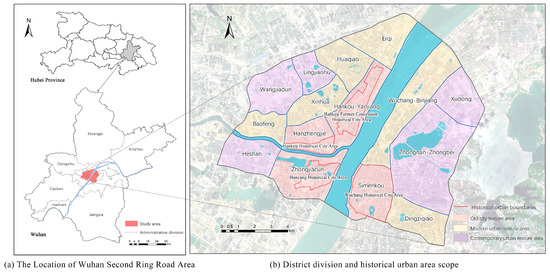
Figure 1.
Location and division of Wuhan Second Ring Road Area.
2.2. Data Sources
This study collected vector data of the building outlines, roads, and water systems (rivers and lakes) in Wuhan from the Wuhan Municipal Research Institute of Surveying and Mapping. Buildings within the second ring road were obtained by tailoring. The building attribute fields included information such as the number of floors, base area, and length of edges. Additionally, the internal division map of the Wuhan Second Ring Road Area was generated based on the road date, and the Urban Digital Elevation Model (UDEM) was constructed according to the building height data.
3. Methods
3.1. Methods for Construction of Complex Networks of Urban Buildings
In a percolation study, the first step is to determine the underlying network and its structure for percolation occurrence [62]. The urban spatial structure is the spatial form manifested by the interconnections and interactions of various elements. The construction of urban spatial networks generally utilizes spatial syntax to transform urban spatial objects or open spaces into topological connection graphs. The geometric and metric attributes of the space are internalized into the structure, allowing the graph analysis to incorporate non-local or extrinsic properties of the space [63]. In this study, building floor plans are transformed into topological graphs of spatial nodes and connecting lines using topological analysis and weighting methods, thus constructing a complex network of buildings. The process of network construction is illustrated in Figure 2.
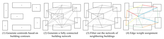
Figure 2.
The method of building a complex network construction.
Initially, an all-connected building network map is generated based on the building’s center of mass. Then, the nearest-neighbor building contact network is filtered. The building distance is the most fundamental attribute of the urban texture at a two-dimensional scale, representing a fundamental structural feature that is independent of the building orientation, plane form, and combination mode [60]. The nearest Euclidean distance between the building contours is calculated using the nearest-neighbor analysis tool as the edge weight. In addition, this study introduces the height difference between neighboring buildings as an edge weight coefficient when constructing a two-dimensional urban architectural complex network based on building distances. The building height is the most intuitive factor in maintaining the visual balance of the urban texture, serving as a significant representation of the urban texture at a three-dimensional scale [64]. The preservation of the old urban texture, especially in historic districts, emphasizes the consistency of architectural style creation and often involves controlling the heights of buildings. The rate of change in height reflects the degree of variation in the building height within the texture. In this study, the rate of change in height for each individual building is calculated to represent the differences in neighboring buildings’ heights [65].
3.2. Urban Texture Identification Method Based on Percolation Model
Suppose that there exists a percolation network, denoted as G. In this network, there is a probability, denoted as p, that a node or edge will be encroached upon. Uniform percolation occurs when p is a scalar, and non-uniform percolation occurs when p is a vector of more than one dimension [66]. During the percolation process, numerous connected subsets of encroached nodes, known as percolation clusters, are formed. These clusters vary in size, as depicted in Figure 3. When p is equal to 0.2, the overall connectivity of the network is very poor, and the clusters exhibit fragmentation characteristics. As the value of p increases, both the overall connectivity of the network and the size of the clusters improve. Eventually, clusters capable of spanning the entire network are formed.
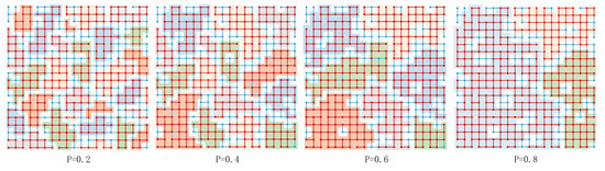
Figure 3.
Cluster structure identification based on percolation model.
The architectural complex network can be regarded as a non-uniform percolation model. In this model, a scale threshold is defined, and percolation occurs when the attribute value of a certain edge is smaller than this threshold. Conversely, if the attribute value is greater than the threshold, no percolation occurs. By gradually eliminating invalid connections based on the threshold value, clusters that are not connected to each other can be identified. These clusters, which vary in size under different thresholds, represent the urban texture. The scale of the texture is determined by the number of buildings contained in the clusters [60]. Since the urban texture is a collection of architectural elements with a certain scale attribute [67], this study considers clusters with a scale larger than 50 as urban texture patches. To visualize the texture, Tyson polygons (Voronoi diagram) are generated using the center of mass of each building. By merging all Tyson polygons belonging to the same cluster, the texture surface is obtained. Theoretically, as the threshold value decreases, the texture surface becomes increasingly fragmented and the scale difference gradually diminishes.
In a percolation network, even a slight variation in p can result in a significant connection between disjointed clusters within the network [66]. This connection, in turn, causes a sudden change in the state or characteristics of the entire network. In this study, the hierarchical changes in the urban texture features across various distance scales are examined, including indicators of the texture area, the number of clusters, the average cluster size, the standard deviation of the scale, and the maximum texture cluster size, to explore the scale-dependent characteristics of different types of urban texture.
3.3. Comprehensive Index System for Urban Texture Measurement
The urban texture is influenced by multiple morphological factors, making it challenging to reflect the distinctions in different texture forms using a single morphological indicator [68]. To address this issue, this paper constructs a comprehensive index system to quantitatively measure texture. This system consists of three categories: the intensity index, morphology index, and texture index. The intensity indicators, including the building density, floor area ratio, and average number of floors, are employed to assess the construction intensity of the texture area. The morphology indicators, such as the average building base area, average shape index of buildings, and weighted shape index of the building area, are used to characterize the shapes of building units within the texture area. Lastly, the texture indicators, comprising the building edge density, building dispersion, and sky openness, provide insights into the fragmentation of texture clusters, as well as their compactness and openness.
The shape index is a measure of the relationship between the area and perimeter of a shape, providing an indication of its regularity [69]. For the combination of buildings within the unit, two calculation tools are used: the average shape index of buildings and the area-weighted shape index [70]. The latter assigns weights to the shape index based on the proportion of individual buildings to the total area of the in-unit building footprint. Both calculations are derived using the following formulas:
where P is the length of the building sideline; S is the building footprint; and n is the number of buildings in the unit. The smaller the shape index, the closer the building plan form is to a square.
Building dispersion is a metric used to assess the distribution of buildings within a unit, indicating whether they are widely scattered or concentrated in a specific area [71]. The dispersion is proportional to the number of buildings in the unit and inversely proportional to the unit area and the standard deviation of the building area. The formula is as follows:
where BD is the building dispersion, and the larger its value, the higher the dispersion of the building in the unit; n is the number of buildings in the unit; B is the land area of the unit; k is the standard deviation of the building area; Fi is the building base area; Li is the number of building floors; Fa is the average base area of the buildings in the unit; La is the average number of floors of the buildings in the unit.
The sky view factor (SVF) is a quantitative description of the degree of openness of the surface space, reflecting the degree of obstruction of the view by the surrounding buildings within the hemisphere. The SVF takes a value of 0 to 1, with a value of 1 indicating the unobstructed visibility of the sky [72]. The calculation formula is as follows:
where β and α are the surface slope angle and surface slope direction calculated from the UDEM, respectively; φ is the horizon angle; and is the azimuthal direction. The SVF calculations are performed using a digital elevation model-based algorithm developed in SAGA-GIS by setting two input parameters, the number of directions and the search distance [73,74].
3.4. Methods of Measuring Urban Texture Toughness
The toughness of the urban texture refers to its ability to maintain its integrity and stability, as well as its resistance to changes in the surrounding environment. In the case of urban historical areas, it is crucial to protect the traditional patterns and historical landscapes in their entirety. This helps to minimize the spatial encroachment and destructive impacts on the landscape that may arise from urban development and construction. “Large scale depends on small scale” is a reasonable scale dependence pattern for the urban texture. Once established, it is difficult to alter the organization of the urban texture at a large scale. However, changes at a small scale do not depend on the larger scale and are therefore easier to implement [38].
To analyze the cross-scale containment relationship of texture clusters, a tree diagram is used in this study. Additionally, the multi-scale texture toughness measurement index proposed by Shen Yao is adopted [60]. This metric considers the linkage between two buildings to have the highest robustness if it consistently falls under the largest cluster at each scale of measurement. The formula is as follows:
where TRij is the robustness of the textural connection between buildings i and j, ranging from 0 to 1, and the larger the value, the higher the robustness; l is the hierarchical scale of the study; D is the number of hierarchical scales; is the size of the cluster to which the connection between buildings i and j belongs under the hierarchical scale l; is the size of the largest cluster under the hierarchical scale l.
4. Results
4.1. Results of Building Complex Network Construction
The complex network of buildings and the weighted distance statistics of the network edges in the Wuhan Second Ring Area are shown in Figure 4 and Figure 5. In the network, 14.82% of the edges have a weighted distance of 0, indicating that these buildings are spatially adjacent but typically belong to different blocks within the same building. The highest proportion, 18.56%, of edges in the network have a weighted distance of 0–5 m. Furthermore, nearly half of all edges have a weighted distance of less than 10 m, illustrating the overall compact layout of the architectural texture within the district.
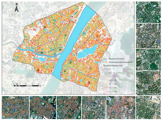
Figure 4.
Complex network of buildings in Wuhan Second Ring Area.
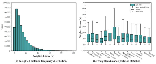
Figure 5.
Statistics of weighted distances to the edges of the complex network in the Wuhan Second Ring Road Area.
Analyzing the spatial distribution reveals that the network with shorter sideline distances is predominantly concentrated in the old city. Hanzheng Street has the smallest average weighted distance, measuring only 8.24 m. Additionally, there are extensive areas of close architectural connection in the Baofeng, Huaqiao, Erqi, and Wuchang Binjiang–Xujiapeng areas of the modern city district. The three areas with the largest weighted distances are the Xudong, Zhongnan–Zhongbei, and Wangjiadun CBD areas. Compared with other contemporary urban areas, the Heshan area exhibits relatively close architectural connectivity.
4.2. Identification Results of Texture Clusters at Different Scale Levels
Figure 6 presents the results of the texture cluster identification within the range of 5 to 50 m distance thresholds, based on the percolation model, and the spatial distribution of the top ten texture clusters in the Hankou, Hanyang, and Wuchang areas is shown in Figure 7. At the 5 m threshold, only a small amount of urban texture emerges, primarily in the western part of the old city of Hankou, the southern part of the former Concession Historic District, and the western part of the old city of Wuchang. Additionally, texture clusters are observed in the urban villages and old communities of modern districts such as Huaqiao, Erqi, and Baofeng. As the distance threshold increases to 10 m, texture clusters start to appear in larger quantities, albeit on a smaller but denser scale. Notably, the spatial distribution pattern of the texture clusters revolves around the four major historic districts, with Hanzhengjie in Hankou and Tanhualin and Xujiapeng in Wuchang witnessing the emergence of slightly larger clusters first. However, texture clusters in contemporary urban districts like the Wangjiadun CBD, Zhongnan–Zhongbei, and Xudong remain relatively scarce.
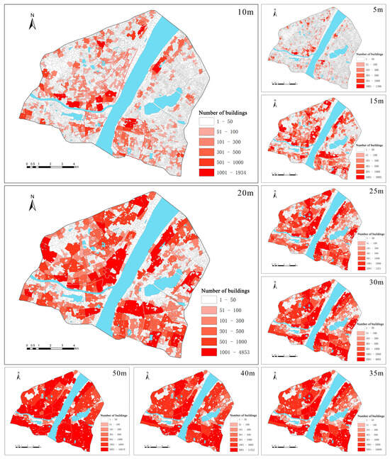
Figure 6.
Identification results of texture clusters at different scales in Wuhan Second Ring Road Area.
Figure 7.
Spatial distribution of the top ten texture clusters in the Hankou, Hanyang, and Wuchang areas.
Further increasing the distance threshold reveals the appearance of large-scale and complete texture areas, transitioning from a fragmented urban texture to area-based characteristics. This transition allows for the observation of spatial differentiation in the urban texture. In the 15–20 m range, large-scale texture clusters dominate the old city plate, particularly in the former Concession Historic Area from Jianghan Road to Yiyuan Road in Hankou and the Liangdaojie Area in the Wuchang Historic City. Subsequently, numerous large-scale clusters in modern urban texture areas emerge, such as the Huaqiao and Erqi districts on the outskirts of Hankou and the Dingziqiao district in Wuchang. Nevertheless, the former Concession Historic District in Hankou remains the largest texture cluster, while the Dingzhiqiao district gradually consolidates to become the largest texture cluster in Wuchang. At 40 m and larger scales, the texture pattern of contemporary urban areas becomes regular and complete. The distribution pattern of the texture aligns with the division of the urban space by expressways and main roads to some extent. Moreover, the texture of the historical urban areas in Hankou and Hanyang within the old city plate extends beyond their boundaries, while the historical urban area of Wuchang gradually forms an independent texture cluster consistent with its own boundaries.
The urban texture is a complex structure with a hierarchical relationship, where different types of texture exhibit distinct morphological patterns at each scale level. The evolution of different urban textures also varies with changes in scale. The old urban texture in both the old city area and modern city area demonstrates the characteristics of small-scale dependence. Numerous texture clusters emerge at small scales and gradually reach a certain scale and completeness. In contrast, the contemporary city area exhibits more sparse and fragmented characteristics. It is fragmented at a small scale and shows the characteristics of regionalization at a large scale.
4.3. Characterization of the Hierarchical Evolution of Texture Clusters
The changes in the relevant measurement indexes of the texture clusters in each area are shown in Figure 8. The coverage rate of the texture clusters reflects the urban texture generation under different thresholds. Apart from the Xudong district, all districts exhibit a pattern of a rapid increase followed by a slower increase. Hanzheng Street and Simenkou, the two old city districts, consistently have the highest coverage rates under each threshold. The coverage rate rapidly reaches 80% within the 20 m range, indicating the small-scale dependence of the texture in the historical urban area. The Xudong district has the lowest coverage rate below the 30 m threshold, but the texture area still rapidly increases at larger scales, while the other districts generally experience a significant slowdown in the rate of texture generation after the 30 m threshold.
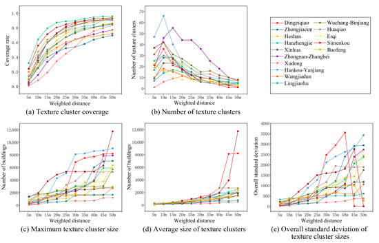
Figure 8.
Index measurement on the evolution of texture clusters in various regions of the Wuhan Second Ring Road Area.
The number of texture clusters generally follows a trend of increasing and then decreasing, peaking at 10 m. The Hankou riverine area stands out with a higher number of texture clusters due to its unique features of small blocks and a dense road network. In the old city area, the fragmented urban texture quickly integrates after reaching the peak, resulting in a sharp decrease in the number of clusters. The three contemporary urban texture areas, Zhongnan–Zhongbei, Lingjiaohu, and Heshan, all reach their peaks at 15 m. Among them, Zhongnan–Zhongbei has a significantly higher number of textures at the mesoscale threshold, partly due to the larger scale of the area and partly due to the emergence of a modern urban texture at a higher level of hierarchy. The Xudong district, as a typical new city district, peaks at 35 m and has a higher number of textures compared to most districts at the peak.
The average and maximum size of the texture clusters increase gradually with the distance threshold. The old city area demonstrates higher sensitivity to changes in scale. The Hankou–Yanjiang area and the Simenkou area exhibit a higher texture scale at the small-scale level compared to other areas. At the medium-scale level, the Dingziqiao and Huaqiao areas in the modern city showcase larger-scale texture clusters. At the large-scale level, the Zhongnan–Zhongbei area stands out as the only contemporary texture area with the largest texture clusters. In contrast, the size of the texture clusters in other contemporary urban areas shows less variation with scale. The dominance of large-scale spaces and buildings in these areas results in the maximum and average sizes of the texture clusters being much lower than those in the old city areas, despite the larger texture areas in the large-scale hierarchy.
The overall standard deviation at different scales reflects the differences in the size of all texture clusters within each urban district, and the internal differences in all districts show an increasing trend. The texture clusters maintain more similarity at smaller scales. At larger scales, the Simenkou and Dingziqiao areas merge into a single large-scale texture cluster. Therefore, there are no differences between the urban texture patches, resulting in a standard deviation of 0. On the other hand, the differences in size between the texture clusters in the Wangjiadun CBD, Lingjiaohu, and Xudong districts exhibit less variation across scale levels, indicating that the texture clusters in contemporary urban districts share similarities with each other.
The distribution of the texture clusters fusing in the hierarchical evolution process is determined by overlaying the urban texture at different scales. This analysis only considers the fusion between identified urban texture clusters at various scales and does not include the fusion of texture clusters with non-texture patches. The results of this identification process are shown in Figure 9, where darker colors indicate a higher number of texture cluster fusions.
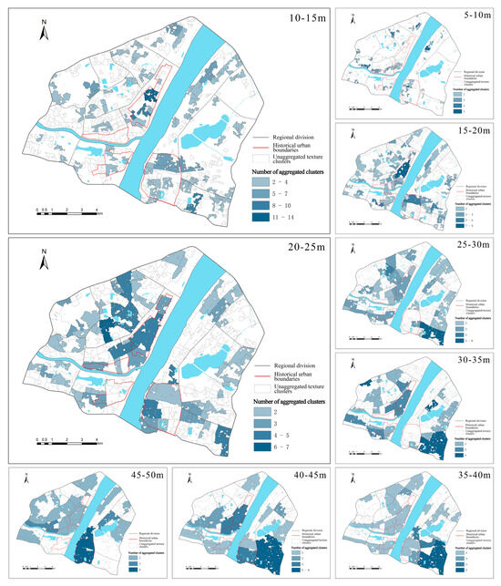
Figure 9.
Analysis of the cross–scale integration process of texture clusters in the Wuhan Second Ring Road Area.
Between 5 and 10 m, the fusion process only occurs in the historic urban area, urban villages, and old neighborhoods. From 10 to 15 m, the fusion process increases significantly in all areas except the contemporary urban area. The fusion rate of the former tenement historic urban area in Hankou accelerates, while the rest of the areas show little difference. Between 15 and 20 m, the fusion of the texture clusters is dominated by Hankou–Yanjiang and the Simenkou old urban area, and large-scale texture clusters are formed first. The small-scale dependence of the old city texture allows internal buildings to coalesce spatially and form complete texture clusters at a small scale. The closely connected texture buildings maintain the integrity and internal connectivity of the texture. Subsequently, the integration of the texture in modern urban areas accelerates significantly. The integration process is evident in the Xinhua, Huaqiao, and Dingziqiao areas within the range of 20 to 40 m. The integration of the contemporary urban texture mainly occurs at large scales and progresses at a slower pace.
There is a difference in the scale characteristics of integration between the Hankou and Wuchang historic districts. The integration process between the former Hankou Concession Historic District and the surrounding texture occurs at all scales. In contrast, the Wuchang Historic District breaks through its own boundary and integrates with the surrounding texture only within the range of 45 to 50 m, making its separation from the surrounding area more pronounced.
4.4. Quantitative Measurement of Spatial Heterogeneity of Texture Clusters
The characteristics of different types of texture are analyzed from the perspective of the urban texture morphology, and the intrinsic reasons for the differences in texture scale-dependent features are explored. From the results of the identification of texture clusters at different scales, it is evident that identifying texture clusters at too small a scale results in incomplete and fragmented spatial information. On the other hand, fusing texture clusters at too large a scale leads to an oversized texture scale, which masks the distinctive characteristics of the urban micro-texture. To measure the morphological indexes, the 20 m scale-level myo-morphological clusters were selected based on the phase variations of the coverage index (Figure 8). The results of these measurements are presented in Figure 10.
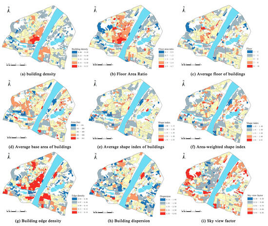
Figure 10.
Quantitative measurement results of spatial heterogeneity of texture clusters in Wuhan Second Ring Road Area.
The intensity index measurement reveals that high-construction-intensity texture clusters are predominantly found along the river in Hankou, Hanzheng Street, and Simenkou Old Town. The area from Wusheng Road to Jianghan Road exhibits the highest building density, reaching 50%. Conversely, the Wangjiadun, Xudong, Zhongnan–Zhongbei, and Heshan areas generally exhibit a lower texture construction intensity. The clusters of high-rise buildings have a small-scale, point-like, discrete distribution pattern. On the other hand, the clusters of low-rise buildings are more closely related to clusters with low volume rates, which have a larger scale. Among the four historic districts, the Wuchang Historic District has the lowest number of building floors.
Examining the shape indexes, we note that large-scale building textures are mainly clustered in the southern part of the Wangjiadun area, the western part of the Xinhua area, and the northern part of the Hanzhengjie area in Hankou. These clusters consist primarily of residences, factories, and public buildings. In Wuchang, they are dispersed and mainly comprise high-rise residential buildings. Small-scale architectural textures are predominantly distributed in the historical urban area, urban villages, and old urban residential areas. When considering the area-weighted shape index measure, more regular and irregular texture clusters are identified. Generally, the shape index of the small-scale architectural texture is lower, indicating a more regular architectural form. Notably, the architectural form index of the texture clusters in the Xinhua district of Hankou, Zhongnan–Zhongbei, and the Xudong district of Wuchang is larger.
Turning to the texture index measure, the edge density of textured buildings in historical urban areas, which reflects building fragmentation, is generally high. This is often manifested by a dense distribution of small-scale buildings in space. Specifically, the dispersion of the buildings in the Wuchang historical urban areas is relatively high. However, in the southern part of Hankou, the Wuchang–Dingziqiao area, and the Heshan area of Hanyang, the dispersion of the buildings is relatively poor. Moreover, the degree of coupling between the sky openness and construction intensity is high, with a higher construction intensity associated with lower sky openness. The dense concentration of buildings in the old cities of Hankou and Hanyang contributes to reduced sky openness, whereas the historical urban area of Wuchang benefits from relatively higher sky openness due to its lower number of building layers.
Urban texture patches exhibit spatial diversity and heterogeneity. The index system shows the complexity of the urban texture form from different dimensions. There is a certain correlation between different texture indicators. For example, the small-scale building texture tends to have more regular building forms, while areas with a high floor–area ratio have a less open sky. However, despite belonging to the same texture type, the morphological characteristics are not completely similar. For instance, historical urban areas are generally characterized by a higher construction intensity and dispersion, but they exhibit noticeable differences in the floor height, building volume, and shape index.
Urban districts typically consist of multiple texture types, and the same type of texture has the characteristics of cross-district agglomeration and distribution. Examples include a high volume rate texture, low-rise building texture, large-scale building texture, and fragmented building texture. The size of the texture clusters at different scales can be determined by various indicator systems. Larger-scale texture clusters are typically characterized by a high building density, low number of floors, regular building shape, and high fragmentation, among other features.
4.5. Measurement of Texture Toughness
The texture clusters exhibit cross-scale containment relationships in space, where small-scale texture clusters are part of the larger-scale hierarchy of texture clusters. A dendrogram is utilized to depict the inclusion relationship among the texture clusters at different scales and analyze the evolutionary relationship of the largest and sub-largest clusters in the Hankou, Wuchang, and Hanyang areas, as shown in Figure 11. The texture tree structure in the Hankou and Wuchang areas is large, and the differentiation rate is slow and uniform, while the Hanyang area is characterized by a simple tree structure with a “slender” shape and rapid differentiation at smaller scales.
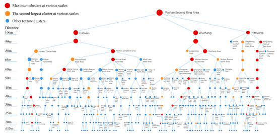
Figure 11.
Hierarchical relationship of texture clusters in Wuhan Second Ring Road Area.
The Hankou area is divided into two distinct clusters: the Hankou Historical and Cultural Landscape Area and the peripheral area at the 80 m level. The largest cluster in Hankou, at the 60–80 m scale, is primarily distributed in the peripheral area. The Hankou Old Town Area, at the 50 m scale and below, serves as the largest cluster, being further divided into Hanzheng Street, the former Concession Historic District, and other historical clusters. The largest cluster in Wuchang at the 30–80 m scale consistently originates from the original largest cluster, among which the largest cluster at the 30–60 m scale is located in the Zhongnan–Zhongbei and Dingziqiao branches. The Wuchang Historic District cluster, at the 50 m scale, is independently visible and serves as the second-largest cluster in the Wuchang area. Additionally, the cluster in the Liangdao Street area at the 25 m scale and below becomes the largest texture cluster. In the Hanyang area, the largest and second-largest clusters at the 40–90 m scale are located in two different branches: Jiangcheng Avenue East and West. The historical areas of Hanyang Old Town and Guiyuan Temple, which belong to the branch of the largest cluster, appear and become the largest or sub-largest clusters, respectively, at the 30 m scale and below. In summary, the clusters produced by the differentiation of Hankou, Wuchang, and Hanyang Old Town, or the larger clusters including them, tend to appear as the largest or sub-largest clusters with good continuity and have strong texture toughness.
The quantitative measurement results of the texture toughness of the Wuhan Second Ring Road Area based on the hierarchical inclusion relationship of the texture clusters are shown in Figure 12. These findings align with the tree diagram analysis, indicating that the texture of the old city area exhibits higher toughness compared to the modern city. Specifically, the Youyi Road to Sanyang Road area, belonging to the former Hankou Concession Historic District, the Liangdao Street area, belonging to the Wuchang Historic District, and the northern part of the Zhanjiang Road area, belonging to the Hanyang Historic District, demonstrate the highest texture toughness. These areas maintain the integrity and connectivity of the historical building texture within the multi-scale hierarchical texture network. Despite the detrimental impact of a small number of point-cluster high-rise buildings, they are resilient enough to withstand the large-scale destruction of the surrounding texture features. However, within the historical urban area, the texture of the Hankou Sanyang Road to Wuhan Tiandi area and Guishan North area lacks sufficient toughness. The former area is dominated by modern large-scale urban buildings, and it is obviously different from the original concession area in Hankou adjacent to the south, resulting in weak architectural connections. The Guishan North area is hindered by natural factors such as mountains and rivers, leading to the weak spatial dependence of the texture on its external surroundings.
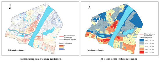
Figure 12.
Measurement results of texture toughness in Wuhan Second Ring Road Area.
In the modern urban texture area, the Dingziqiao area exhibits the highest texture toughness. The eastern Xinhua area, the northern Huaqiao area, and the southern Zhongnan–Zhongbei area also demonstrate relatively good texture toughness. On the other hand, the Hankou Lingjiaohu area and Wuchang Xudong area exhibit the lowest toughness among the contemporary urban texture areas. This is partly due to the requirement of large-scale building spacing, which weakens the architectural connections and makes it difficult to maintain the texture stability at a small scale. Additionally, blockages in the main roads surrounding these areas further weaken their spatial connections with the external environment.
5. Discussion
5.1. The Rational Organization of the Urban Texture
The formation of the traditional urban morphology relies on the pedestrian traffic network, and the pedestrian-oriented city, which has gradually developed over time, follows a fractal model [75], with its texture elements tightly connected at a small scale. When the city grows to a certain scale, certain urban textures are dismantled to accommodate new large-scale structures, such as wider roads and large parks. This transformation shifts the city from being pedestrian-oriented to car-oriented [76]. The intrinsic value of the old urban neighborhoods is underestimated, and their structures are often seen as chaotic. In the process of urban construction and development, many buildings and blocks that should be preserved have suffered from destructive destruction and encroachment. When the occupied land does not align with the original urban texture, the fragmentation of the urban texture occurs [77].
In modernist planning, the organization of the urban texture often involves placing similar elements and blocks together, leading to strict functional zoning and monotonous architectural use. This approach results in the unreasonable organization of the urban texture. Similar to Le Corbusier’s modernist urban vision [78], current urban development based on large-scale skyscrapers, highways, and open spaces overlooks the need for small-scale hierarchical structures that are essential for a vibrant city. When a city lacks small-scale elements and connections in its structure, it loses its fractal characteristics. The vitality of a city comes from its connectivity, and the existence of all geometric forms is intended to create a connected network for people to interact with each other [79]. However, modernist urban planning, while emphasizing the material quality of the built environment, often neglects the specific behavioral patterns of people in real spatial settings. Urban life requires a well-connected network of pedestrian-friendly spaces that follow an inverse power-law distribution across different scales [76].
The urban texture is the outcome of various factors that accumulate over time. The texture of modern and contemporary urban areas differs from that of traditional historical urban areas. When planning urban spaces, it is important to preserve the organic structure inherited from the traditional city while also accommodating the modern city’s need for spatial order. Achieving the harmonious integration of these two aspects is a crucial consideration in current urban planning and design projects. In the process of urban fabric organization, both the Caniggia and Conzen schools emphasize the continuity of history in the urban form, advocating for the preservation of the historical buildings and urban fabric to maintain the identity and culture of the city [28]. The methods of typological extraction and reconstitution can be applied to urban planning and design. However, the rationality of urban fabric organization lies not only in the replication process of fabric prototypes but also in the continuation of fabric connectivity structures.
The rational organization of the urban fabric exhibits a stable fabric structure, characterized by the consistency achieved through the interconnectedness of each node. The tight connection across multiple scales in the urban fabric helps to prevent the disruption caused by construction activities. Applying fractal theory to urban design, the key aspect of fractals lies in their hierarchical structure, where a fractal city consists of structural components at all scales, ranging from the overall city scale to the detailed building materials. Cities need to achieve connectivity at all scales, maintaining a balance between large-scale and small-scale connections [80]. By integrating both bottom-up and top-down planning approaches, a city spontaneously generates its urban fabric at a small scale, while being influenced by planning interventions. However, planning should be based on the maintenance of urban texture growth and establish large-scale connections strictly according to hierarchical positions [81]. The interaction interfaces between different scales should be achieved without destroying each other, maintaining fractal interfaces that are conducive to the preservation of traditional texture scales and boundaries. Through the examination of the texture at different characteristic scales, the stability of the urban texture at critical scales can be ensured.
5.2. Suggestions on Urban Texture Optimization in Wuhan
As for the historical urban area, the former Hankou Concession Historic District, with its joint influence of Western and local cultures since its opening in modern times, has developed a distinct urban texture characterized by courtyard-style Rifen, neighborhood apartments, and courtyard-style foreign firms’ mansions. However, the demolition of Rifen and old bank buildings, along with the subsequent construction of modern high-rise buildings during the reform and opening-up period, has resulted in a fragmented historical texture. The coexistence of historical plots, mixed plots, and modern high-rise buildings has gradually formed, and modern buildings have intensified the rupture of the historical texture. Similarly, the architectural texture of the Wuchang Old City exhibits a dense pattern in the north and a sparse pattern in the south. The northern area comprises mainly low-rise, compactly distributed buildings, while the southern area has been greatly affected by the dotted damage caused by high-rise buildings and the fragmentation caused by large public buildings. To preserve the stability of the texture network in the renewal and reconstruction of the historical city, it is crucial to employ a local and small-scale progressive adjustment approach, utilizing urban acupuncture methods for precise interventions [82]. This approach allows buildings of different ages and functional conditions to coexist, reflecting the evolution of architectural archetypes over time. Additionally, in the planning process, an emphasis should be placed on enhancing the continuity between the historical urban area and the surrounding environment, as the integration of the Wuchang Old City with its surroundings is relatively weak compared to the old city of Hankou.
The modern urban texture is characterized by a mixture of old and new architectural styles in the Wuhan Second Ring Road Area. The majority of old buildings, which consist mostly of multi-storey townhouses, are being demolished and rebuilt during the renewal process. As a result, the renewed area is dominated by high-rise and large-scale buildings, leading to organizational differences and spatial conflicts between the old and new textures. This situation has resulted in fragmented patches of texture and contrasting landscapes. In the process of district renewal, the focus should not solely be on the modernization and consistency of the urban texture and landscape. Instead, it should prioritize the reorganization and integration of the overall environment and functional structure of the block. Based on the current situation, the protection of the more intact internal texture should be the core consideration. Spatial stitching theory can be utilized to identify and connect fractured areas of the landscape texture [83]. By employing axial connections and integrating the node spaces of the band, the fragmented urban texture and functionality can be reconciled and reorganized.
New urban towns, on the other hand, are independent and complete contemporary urban texture areas located on the city’s periphery. Due to large-scale construction activities such as mega blocks and wide roads, texture disconnection may occur. The planning of new towns should prioritize compact land use layouts, the mixing and upgrading of incompatible functions, and the maintenance of the human scale. By controlling the building scale and integrating the external spaces of the buildings, the continuity of the architectural texture can be preserved [84].
6. Conclusions and Outlook
6.1. Conclusions
This study applies network percolation theory to examine the urban texture in Wuhan’s Second Ring Road Area. It quantitatively analyzes the scale dependence and cross-scale evolution of different types of texture patches and measures the spatial heterogeneity of the texture clusters and texture toughness, revealing the intrinsic mechanism behind the scale dependence of the city’s texture. The main conclusions of the study are as follows.
- (1)
- Different types of urban texture exhibit distinct morphological patterns at different scales, and their evolution varies with scale changes. The old urban texture exhibits small-scale dependent characteristics, emerging in large quantities at small scales and reaching a certain scale and completeness first. The contemporary urban texture experiences fragmentation at small scales and demonstrates regionalization characteristics at larger scales.
- (2)
- The texture of the old city is highly sensitive to scale changes, expanding rapidly at small scales. It has higher texture coverage, a larger number of clusters, and the maximum texture size compared to other districts. In contemporary urban districts, the size of the texture clusters and differences in cluster size show less variation across scales. The dominant process of texture integration shifts from the old city area to the modern city area as the scale changes. The old city area maintains its texture integrity and internal connectivity at small scales, while the integration process for the contemporary city texture occurs at larger scales and slower speeds.
- (3)
- Urban areas consist of multiple texture types, and the same texture type exhibits cross-area agglomeration and distribution characteristics. There is a certain correlation between the morphological indicators of texture patches, and the morphological characteristics of the same texture type are not completely similar. The size of the texture clusters emerging from a specific scale is determined by various indicator systems. Large-scale texture clusters typically exhibit a high building density, low number of building floors, regular building shape, and high fragmentation.
- (4)
- The connectivity of the urban texture in the multi-scale hierarchical network determines its toughness in resisting external disturbances. The urban texture of the old city area demonstrates strong connectivity in the multi-scale hierarchical network and usually appears as the largest or second-largest cluster, indicating strong textural toughness. The contemporary urban texture, characterized by large-scale building spacing and urban road blockages, weakens the spatial connection between the interior and exterior of the texture, resulting in poor texture toughness.
6.2. Outlook
This study takes into account various types of urban texture at different scale levels, and the range and span of these scale levels are extensive. The findings reveal variations in the scale dependence of each type of urban texture. Therefore, the choice of resolution level should be based on the specific research objective. In the future, it is important to focus on the spatial pattern and evolution of different types of urban texture at a more refined scale.
Author Contributions
S.Y. proposed the research concept, designed the experiments, conducted the data analysis, and composed the manuscript. Q.Z. designed the framework of this research and participated in manuscript editing. K.Z. participated in the data analysis and edited the manuscript. H.P. participated in the data analysis and edited the manuscript. All authors have read and agreed to the published version of the manuscript.
Funding
This research was funded by the National Natural Science Foundation of China (No. 52078389) and the Key Laboratory of Monitoring, Evaluation Early Warning of Territorial Spatial Planning Implementation of Ministry of Natural Resources, China (No. 401147).
Data Availability Statement
The data presented in this study are available on request from the corresponding author. The data are not publicly available due to privacy restrictions.
Conflicts of Interest
The authors declare no conflicts of interest.
References
- Liu, S.; Yu, Q.; Wei, C. Spatial-Temporal Dynamic Analysis of Land Use and Landscape Pattern in Guangzhou, China: Exploring the Driving Forces from an Urban Sustainability Perspective. Sustainability 2019, 11, 6675. [Google Scholar] [CrossRef]
- Wu, J.; Yang, S.; Zhang, X. Interaction Analysis of Urban Blue-Green Space and Built-Up Area Based on Coupling Model—A Case Study of Wuhan Central City. Water 2020, 12, 2185. [Google Scholar] [CrossRef]
- DeVerteuil, G. Urban inequality revisited: From the corrugated city to the lopsided city. Dialogues Urban Res. 2023, 1, 252–270. [Google Scholar] [CrossRef]
- Richard, K. Changing urban fabrics: Thinking through the lopsided city. Dialogues Urban Res. 2023, 1, 288–292. [Google Scholar]
- Leila, A. The semantic value of historical monuments as cultural heritage in urban texture: Cases of Ankara Castle and Anıtkabir. J. Archit. Conserv. 2022, 28, 197–216. [Google Scholar]
- Li, X.; Hui, E.C.M.; Chen, T.; Lang, W.; Guo, Y. From habitat III to the new urbanization agenda in China: Seeing through the practices of the “Three old renewals” in Guangzhou. Land Use Policy 2019, 87, 513–522. [Google Scholar] [CrossRef]
- Whitehand, J.W.R.; Gu, K.; Whitehand, S.M.; Zhang, J. Urban morphology and conservation in China. Cities 2011, 28, 171–185. [Google Scholar] [CrossRef]
- Wang, J. Problems and solutions in the protection of historical urban areas. Front. Archit. Res. 2012, 1, 40–43. [Google Scholar] [CrossRef]
- Said, S.Y.; Aksah, H.; Ismail, E.D. Heritage Conservation and Regeneration of Historic Areas in Malaysia. Procedia Soc. Behav. Sci. 2013, 105, 418–428. [Google Scholar] [CrossRef]
- Tsai, Y.H. Apply urban morphology to study Tainan commercial district fabrics. Sustain. City 2016, 204, 161–170. [Google Scholar]
- Salingaros, N.A. Complexity and Urban Coherence. J. Urban Des. 2000, 3, 291–316. [Google Scholar] [CrossRef]
- Batty, M.; Longley, M. Fractal Cities—A Geometry of Form and Function; Academic Press: London, UK, 1994. [Google Scholar]
- Tara, A.; Patuano, A.; Lawson, G. Between 2D and 3D: Studying Structural Complexity of Urban Fabric Using Voxels and LiDAR-Derived DSMs. Fractal Fract. 2021, 5, 227. [Google Scholar] [CrossRef]
- Chadwick, G.F. A Systems View of Planning; Pergamon Press: Oxford, UK, 1971. [Google Scholar]
- Portugali, J. Self-Organization and the City; Springer: New York, NY, USA, 2000. [Google Scholar]
- Jacobs, J. The Death and Life of Great American Cities; Random House: New York, NY, USA, 1961. [Google Scholar]
- Vaughan, J.; Ostwald, M.J. Using fractal analysis to compare the characteristic complexity of nature and architecture: Re-examining the evidence. Archit. Sci. Rev. 2010, 53, 323–332. [Google Scholar] [CrossRef]
- Salingaros, N.A. Connecting the fractal city. In Proceedings of the Keynote Speech, 5th Biennial of Towns and Town Planners in Europe, Barcelona, Spain, 10–12 April 2003. [Google Scholar]
- Porta, S.; Crucitti, P.; Latora, V. The network analysis of urban streets: A primal approach. Environ. Plan. B Plan. Des. 2006, 33, 705–725. [Google Scholar] [CrossRef]
- Perry, S. The Unfinished Landscape—Fractal Geometry and the Aesthetic of Ecological Design. Ph.D. Thesis, Queensland University of Technology, Brisbane City, Australia, 2012. [Google Scholar]
- Salingaros, N.A.; West, B.J. A universal rule for the distribution of sizes. Environ. Plan. B Plan. Des. 1999, 26, 909–923. [Google Scholar] [CrossRef]
- Carolina, Q.R.; Felipe, J. Urban Fabrics to Eco-Friendly Blue–Green for Urban Wetland Development. Sustainability 2021, 13, 13745. [Google Scholar]
- Tong, M. How urban fabric can help sustain the vitality of cities. Urban Plan. Forum 2014, 216, 85–96. [Google Scholar]
- Li, X.; Cheng, S.; Lv, Z.; Song, H.; Jia, T.; Lu, N. Data analytics of urban fabric metrics for smart cities. Future Gener. Comput. Syst. 2020, 107, 871–882. [Google Scholar] [CrossRef]
- Pont, M.B.; Haupt, P. The spacemate: Density and the typomorphology of the urban fabric. In Urbanism Laboratory for Cities and Regions: Progress of Research Issues in Urbanism; IOS Press: Amsterdam, The Netherlands, 2005. [Google Scholar]
- Cohen, N. Urban Planning Conservation and Preservation; Wang, S., Translator; China Machine Press: Beijing, China, 2004. [Google Scholar]
- Cataldi, G.; Maffei, G.; Vaccaro, P. Saverio Muratori and the Italian school of planning typology. Urban Morphol. 2002, 6, 3–14. [Google Scholar] [CrossRef]
- Whitehand, J. From Como to Alnwick: In pursuit of Caniggia and Conzen. Urban Morphol. 2003, 7, 69–72. [Google Scholar] [CrossRef]
- Cataldi, G. From Muratori to Caniggia: The origins and development of the Italian school of design typology. Urban Morphol. 2003, 7, 19–34. [Google Scholar] [CrossRef]
- Monteiro, C.; Pinho, P. Comparing approaches in urban morphology. J. Urban. 2022, 15, 491–518. [Google Scholar] [CrossRef]
- Chen, F. One New Framework of Study:Application of Urban Typo-morphology to China. Archit. J. 2010, 4, 85–90. [Google Scholar]
- Araldi, A.; Fusco, G. Decomposing and Recomposing Urban Fabric: The City from the Pedestrian Point of View. In Computational Science and Its Applications—ICCSA; Gervasi, O., Murgante, B., Misra, S., Borruso, G., Torre, C.M., Rocha, A.M.A.C., Taniar, D., Apduhan, B.O., Stankova, E., Cuzzocrea, A., Eds.; Springer: New York, NY, USA, 2017; Volume 10407, pp. 365–376. [Google Scholar]
- Marzot, N. The Study of Urban Form in Italy. Urban Morphol. 2002, 6, 59–73. [Google Scholar] [CrossRef]
- Levy, A. Urban morphology and the problem of the modern urban fabric: Some questions for research. Urban Morphol. 1999, 3, 79–85. [Google Scholar] [CrossRef]
- Kropf, K. Urban Tissue and the Character of Towns. Urban Des. Int. 1996, 1, 247–263. [Google Scholar] [CrossRef]
- He, Y.; Deng, W. Research on the prototype and types of architectural texture in historic district. City Plan. Rev. 2014, 38, 57–62. [Google Scholar]
- Batty, M. Cities as Complex Systems: Scaling, Interaction, Networks, Dynamics and Urban Morphologies. In Encyclopedia of Complexity and Systems Science; Meyers, R., Ed.; Springer: New York, NY, USA, 2009. [Google Scholar]
- Fang, Y.; Liu, J. Urban fabric organization based on complex system theory. City Plan. Rev. 2008, 250, 32–37. [Google Scholar]
- Dong, J.; Li, L.; Han, D. New Quantitative Approach for the Morphological Similarity Analysis of Urban Fabrics Based on a Convolutional Autoencoder. IEEE Access. 2019, 7, 138162–138174. [Google Scholar] [CrossRef]
- Moudon, A.V. Urban morphology as an emerging interdisciplinary field. Urban Morphol. 1997, 1, 3–10. [Google Scholar] [CrossRef]
- Chen, F. The Role of Typomorphology in Sustaining the Cultural Identity of Chinese Cities: The Case Study of Nanjing, China. Ph.D. Thesis, Department of Architecture, University of Strathclyde, Glasgow, UK, 2009. [Google Scholar]
- Chen, F. Interpreting urban micromorphology in China: Case studies from Suzhou. Urban Morphol. 2012, 16, 133–148. [Google Scholar] [CrossRef]
- Hall, A.C. Bridging the gap: Applying urban morphology to successful planning practice. Urbn Morphol. 2008, 12, 54–57. [Google Scholar] [CrossRef]
- Whitehand, J.W.R. British urban morphology: The Conzenian tradition. Urban Morphol. 2001, 5, 103–109. [Google Scholar] [CrossRef]
- Xu, R. Research on Nanjing Ancient Urban Morphology Evolution Based on Climate Adaptability. IOP Conf. Ser. Mater. Sci. Eng. 2020, 794, 012021. [Google Scholar] [CrossRef]
- Chen, F.; Romice, O. Preserving the cultural identity of Chinese cities in urban design through a typomorphological approach. Urbana Des. Int. 2009, 14, 36–54. [Google Scholar] [CrossRef]
- Gil, J.; Beirão, J.N.; Montenegro, N.; Duarte, J.P. On the discovery of urban typologies: Data mining the many dimensions of urban form. Urban Morphol. 2012, 16, 27–40. [Google Scholar] [CrossRef]
- Hijazi, I.; Li, X.; Koenig, R.; Schmit, G.; Meouche, R.E.; Lv, Z.; Abune’meh, M. Measuring the homogeneity of urban fabric using 2D geometry data. Environ. Plan. B Urban Anal. City Sci. 2016, 44, 1097–1121. [Google Scholar] [CrossRef]
- Zhang, P.; Ghosh, D.; Park, S. Spatial measures and methods in sustainable urban morphology: A systematic review. Landsc. Urban Plan. 2023, 237, 104776. [Google Scholar] [CrossRef]
- Labetski, A.; Vitalis, S.; Biljecki, F.; Ohori, K.A.; Stoter, J. 3D building metrics for urban morphology. Int. J. Geogr. Inf. Sci. 2023, 37, 36–67. [Google Scholar] [CrossRef]
- Ren, L.; Cao, Y. GIS-based viewshed analysis on the conservation planning of historic towns: The case study of Xinchang, Shanghai. Int. Arch. Photogramm. Remote Sens. Spatial Inf. Sci. 2021, XLVI-M-1, 609–616. [Google Scholar] [CrossRef]
- Mirzaee, S.; Özgun, O.; Ruth, M.; Binita, K.C. Neighborhood-scale sky view factor variations with building density and height: A simulation approach and case study of Boston. Urban Clim. 2018, 26, 95–108. [Google Scholar] [CrossRef]
- Filomena, G.; Verstegen, J.A.; Manley, E. A computational approach to ‘The Image of the City’. Cities 2019, 89, 14–25. [Google Scholar] [CrossRef]
- Ostwald, J.M.; Lee, H. Computational Analytical Methods for Buildings and Cities: Space Syntax and Shape Grammar. Buildings 2023, 13, 1613. [Google Scholar] [CrossRef]
- Lyu, Y.; Malek, M.I.A.; Ja’afar, N.H.; Sima, Y.; Han, Z.; Liu, Z. Unveiling the potential of space syntax approach for revitalizing historic urban areas: A case study of Yushan Historic District, China. Front. Archit. Res. 2023, 12, 1144–1156. [Google Scholar] [CrossRef]
- Li, X.; Lv, Z.; Zheng, Z.; Zhong, C.; Hijazi, I.H.; Cheng, S. Assessment of lively street network based on geographic information system and space syntax. Multimed. Tools Appl. 2015, 76, 17801–17819. [Google Scholar] [CrossRef]
- Christensen, K.; Moloney, N.R. Complexity and Criticality; Imperial College Press: London, UK, 2005; Volume 1. [Google Scholar]
- Li, M.; Liu, R.; LÜ, L.; Hu, M.; Xu, S.; Zhang, Y. Percolation on complex networks: Theory and application. Phys. Rep. 2021, 907, 1–68. [Google Scholar] [CrossRef]
- Molinero, C.; Murcio, R.; Arcaute, E. The angular nature of road networks. Sci. Rep. 2017, 7, 4312. [Google Scholar] [CrossRef] [PubMed]
- Shen, Y.; Xu, Y.; Liu, Y. Urban texture analysis from the perspective of network percolation. Urban Plan. Forum 2021, 265, 40–48. [Google Scholar]
- Deng, H.; Song, F.; Cai, H. Urban tissue and walkability morphological analysis on the essential characteristics of urban walkable space. Archit. J. 2013, 6, 8–13+7. [Google Scholar]
- Zhang, Y.; Guo, L. Network Percolation Based on Complex Network. J. Netw. 2013, 8, 1874–1881. [Google Scholar] [CrossRef]
- Xing, Z.; Guo, W. A New Urban Space Analysis Method Based on Space Syntax and Geographic Information System Using Multisource Data. ISPRS Int. J. Geo-Inf. 2022, 11, 297. [Google Scholar] [CrossRef]
- Yang, H. Multiple Definitions and Analysis of Building Height. Urban. Archit. 2023, 20, 210–213. [Google Scholar]
- Zhang, P. Spatial fluctuation of urban architecture. J. Arid. Land Resour. Environ. 2016, 30, 51–57. [Google Scholar]
- Zhang, L.; Ren, J. Percolation theory, method, progress, and existing problems. Chin. J. Nat. 2019, 41, 119–131. [Google Scholar]
- Liu, Q.; Ding, W. The graphical method and its significance in the study of urban texture form. Architect 2012, 01, 5–12. [Google Scholar]
- Li, X.; Cheng, S.; Li, K.; Chen, C. Data based interpretation of urban fabric: The case of Hankou riverside area. Archit. J. 2017, S1, 7–13. [Google Scholar]
- Basaraner, M.; Cetinkaya, S. Performance of shape indices and classification schemes for characterising perceptual shape complexity of building footprints in GIS. Int. J. Geogr. Inf. Sci. 2017, 31, 1952–1977. [Google Scholar] [CrossRef]
- Saura, S.; Carballal, P. Discrimination of native and exotic forest patterns through shape irregularity indices: An analysis in the landscapes of Galicia, Spain. Landsc. Ecol. 2004, 19, 647–662. [Google Scholar] [CrossRef]
- Li, Z.; Hu, D. Characterization of three-dimensional architectural form change of part of Beijing’s central city from 1990 to 2019. Ecol. Sci. 2023, 42, 49–55. [Google Scholar]
- Miao, C.; Yu, S.; Hu, Y.; Zhang, H.; He, X.; Chen, W. Review of methods used to estimate the sky view factor in urban street canyons. Build. Environ. 2020, 168, 106497. [Google Scholar] [CrossRef]
- Böhner, J.; McCloy, K.R.; Strobl, J. SAGA: Analysis and Modelling Applications; Number 115; Goltze: Gottingen, Germany, 2006. [Google Scholar]
- Bernard, J.; Bocher, E.; Petit, G.; Palominos, S. Sky View Factor Calculation in Urban Context: Computational Performance and Accuracy Analysis of Two Open and Free GIS Tools. Climate 2018, 6, 60. [Google Scholar] [CrossRef]
- Salingaros, N.A. Urban Space and its Information Field. J. Urban Des. 1999, 4, 29–49. [Google Scholar] [CrossRef]
- Salingaros, N.A.; Liu, Y. Connecting the Fractal City. Urban Plan. Int. 2008, 23, 81–92. [Google Scholar]
- Wu, Y.; Chen, S. Study on Suture of Urban Texture Rupture: The Case of Ladies’ Street in Hefei. Archit. Cult. 2021, 01, 168–170. [Google Scholar]
- Andrés, R.L.J.; Daniel, N.C.; Teresa, P.C.M. Le Corbusier’s urbanism: An urban characterisation of his proposals for inner cities. Front. Archit. Res. 2021, 10, 701–714. [Google Scholar]
- Dupuy, G. L’Urbanisme Des Réseaux; Armand Colin: Paris, France, 1991. [Google Scholar]
- Krier, L. Architecture: Choice or Fate, and Reas Papadakis; Windsor: Berkshire, UK, 1998. [Google Scholar]
- Dupuy, G. Les Territoires de l’Automobile; Anthropos: Paris, France, 1995. [Google Scholar]
- Parsons, A. Urban Acupuncture: Marco Casagrande; University of Portsmouth: Hampshire, UK, 2010. [Google Scholar]
- Abdelmonem, G.M.; McWhinney, R. In search of common grounds: Stitching the divided landscape of urban parks in Belfast. Cities 2015, 44, 40–49. [Google Scholar] [CrossRef]
- Yang, J.; Wu, H.; Jin, T. Research on spatial morphology and scale texture of new district planning in China. Urban Plan. Int. 2017, 32, 34–42. [Google Scholar] [CrossRef]
Disclaimer/Publisher’s Note: The statements, opinions and data contained in all publications are solely those of the individual author(s) and contributor(s) and not of MDPI and/or the editor(s). MDPI and/or the editor(s) disclaim responsibility for any injury to people or property resulting from any ideas, methods, instructions or products referred to in the content. |
© 2024 by the authors. Licensee MDPI, Basel, Switzerland. This article is an open access article distributed under the terms and conditions of the Creative Commons Attribution (CC BY) license (https://creativecommons.org/licenses/by/4.0/).