
Mapping Cropland Abandonment in the Cloudy Hilly Regions Surrounding the Southwest Basin of China

Abstract
1. Introduction
- How can we accurately create a cropland abandonment map in the hilly regions surrounding the southwestern basin using a time series of optical satellite images?
- Can Landsat 8, Sentinel-2, and Sentinel-1 imagery contribute to identifying cropland abandonment in areas prone to cloud cover and fragmented land parcels?
- What spatiotemporal pattern characterizes cropland abandonment in the study area, and what are the influencing factors?
2. Materials and Methods
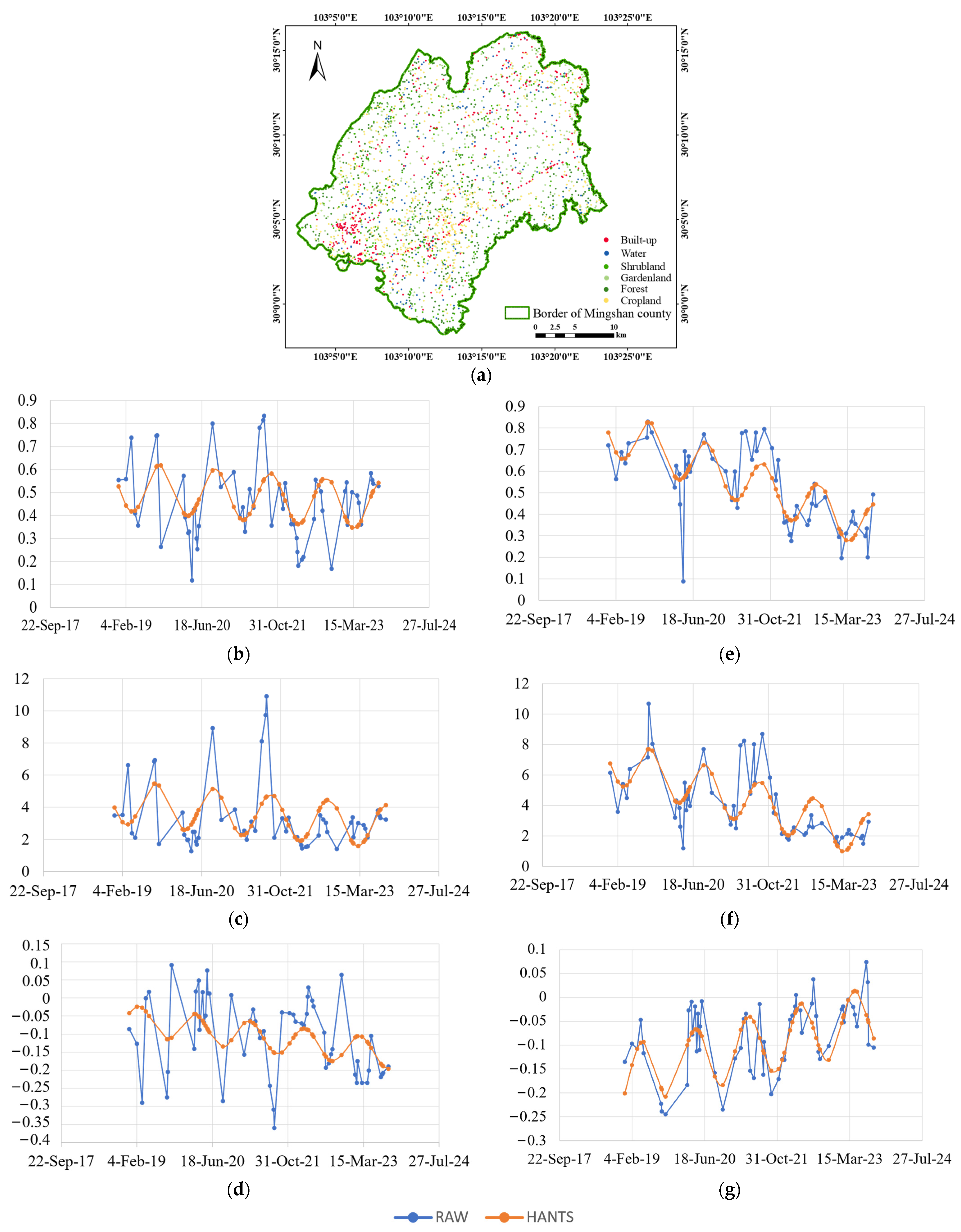
2.1. Study Area
2.2. Data Source
2.3. Mapping the Multi-Year Trajectory of Cropland Abandonment
2.3.1. Data Preprocessing

| Indices | Expressions | Citations |
|---|---|---|
| The modified Dual Polarization SAR Vegetation Index (DPSVIm) | [46] | |
| The Scattering Ratio (CR) | [47] | |
| The Normalized Index (Pol) | [48] | |
| The modified Radar Vegetation Index (RVIm) | [49] | |
| Normalized Difference Vegetation Index (NDVI) | [50] | |
| Ratio Vegetation Index (RVI) | [51] | |
| Bare Soil Index (BSI) | [52] |
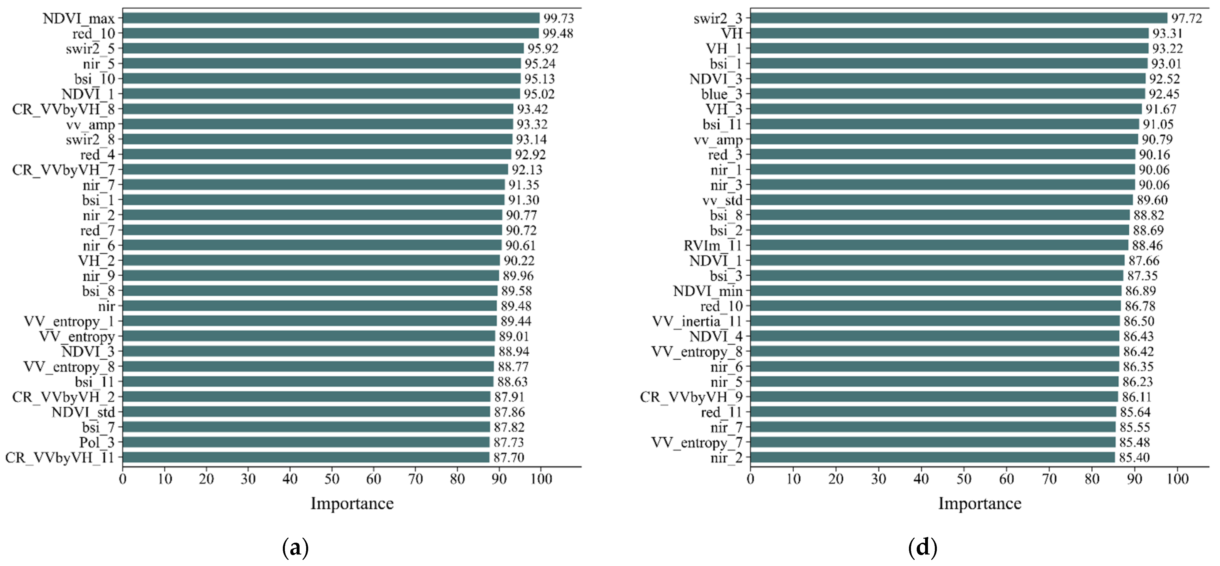
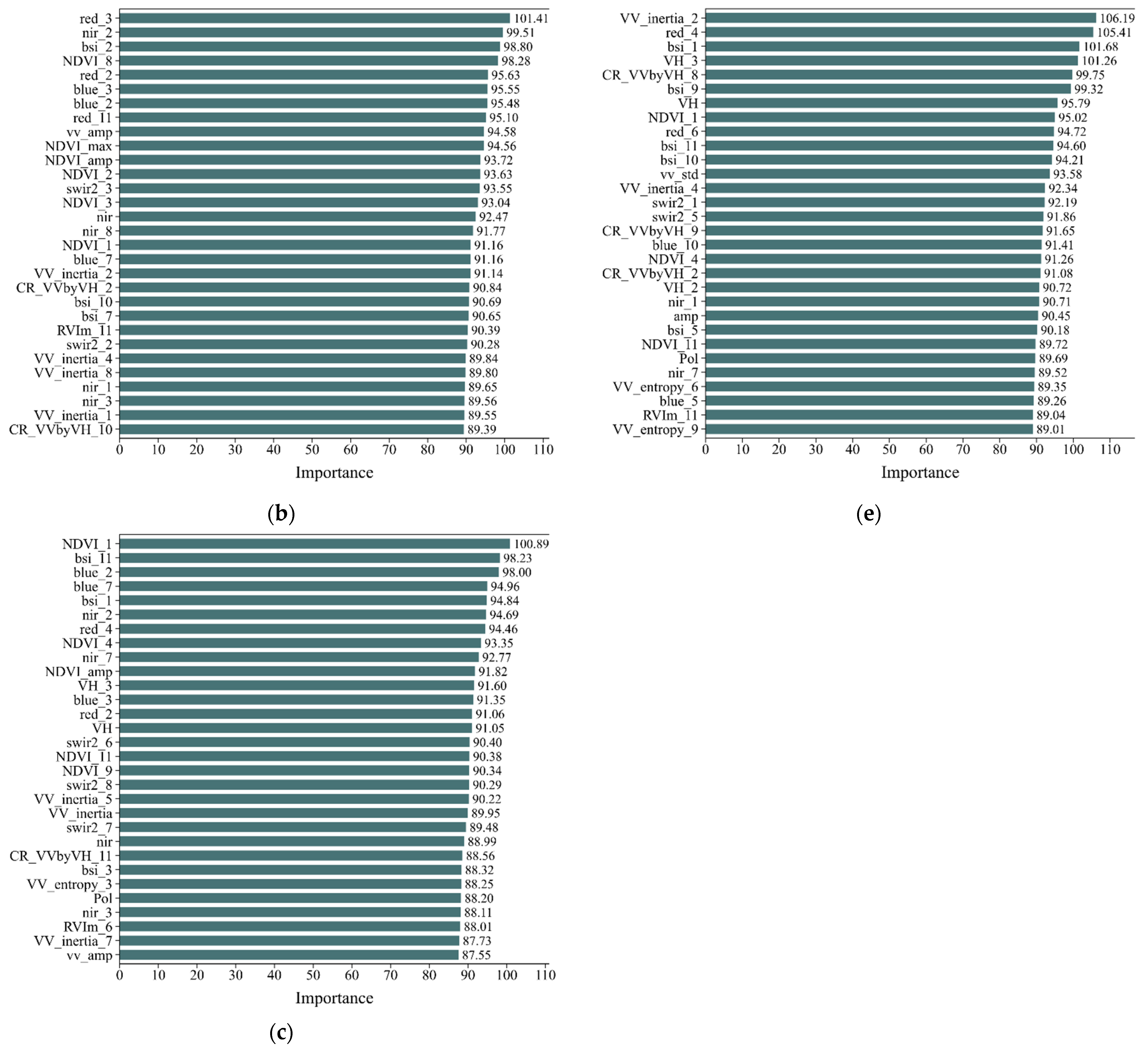
2.3.2. Generate Training Samples
2.3.3. Annual Land Cover Classification
2.3.4. Multi-Year Cropland Abandonment Mapping
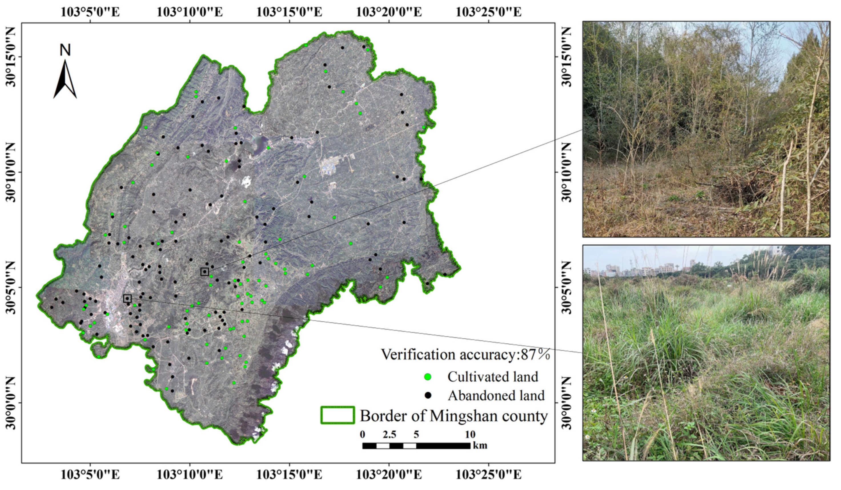
2.3.5. Accuracy Validation
2.4. Analysis of the Spatiotemporal Characteristics and Driving Factors of Abandoned Cropland
2.4.1. Analysis of Spatiotemporal Characteristics of Cropland Abandonment
2.4.2. Analysis of Driving Factors of Cropland Abandonment
3. Results
3.1. Mapping Accuracy
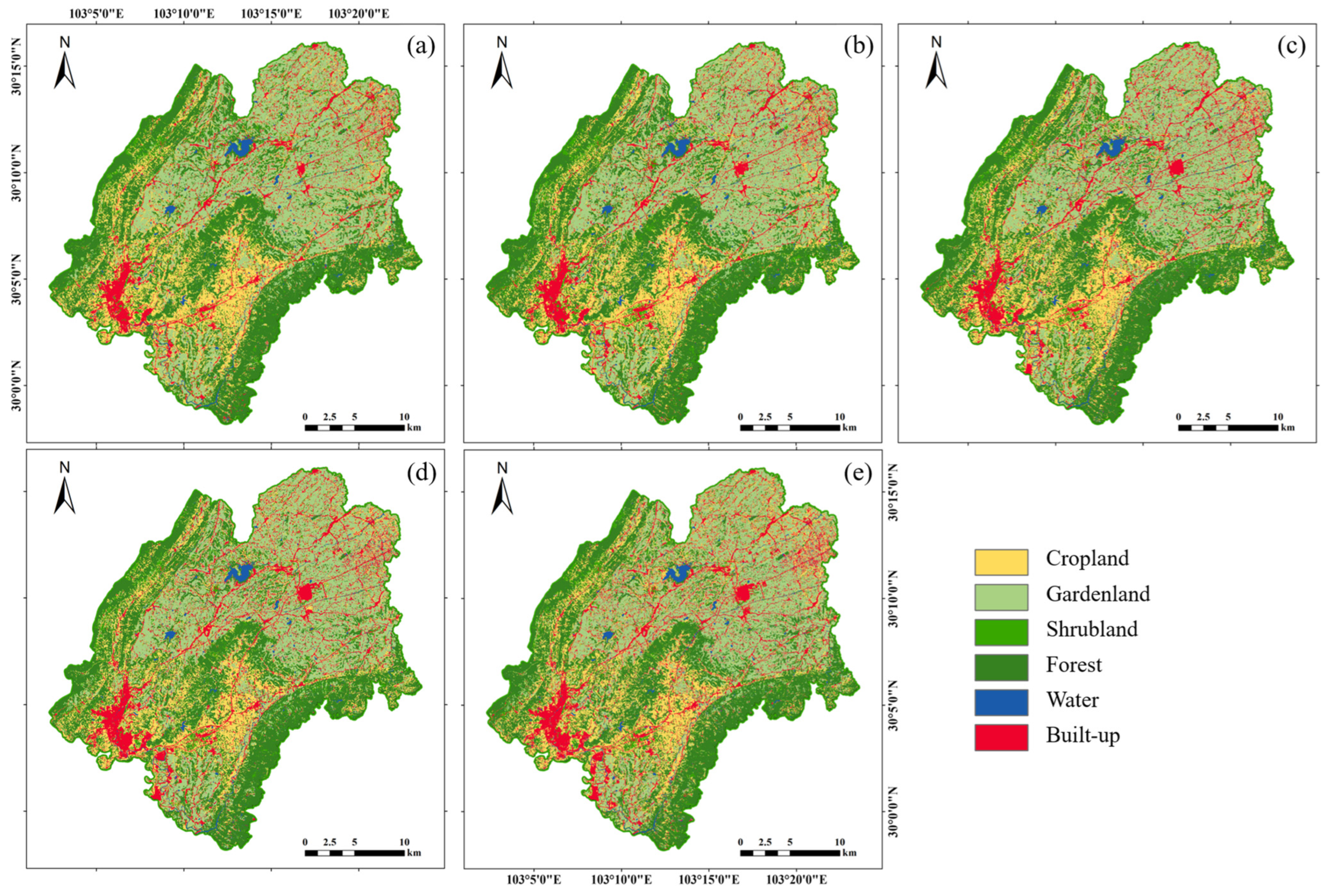
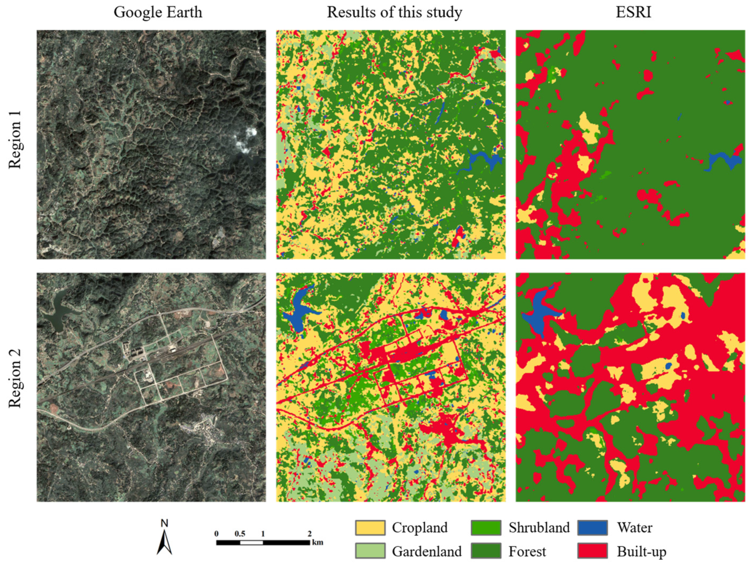
3.1.1. Results of Land Use Classification
3.1.2. Results of Abandoned Cropland Extraction
3.2. Spatiotemporal Characteristics of Cropland Abandonment
3.2.1. Spatial–Temporal Distribution Characteristics of Abandoned Cropland in Various Townships
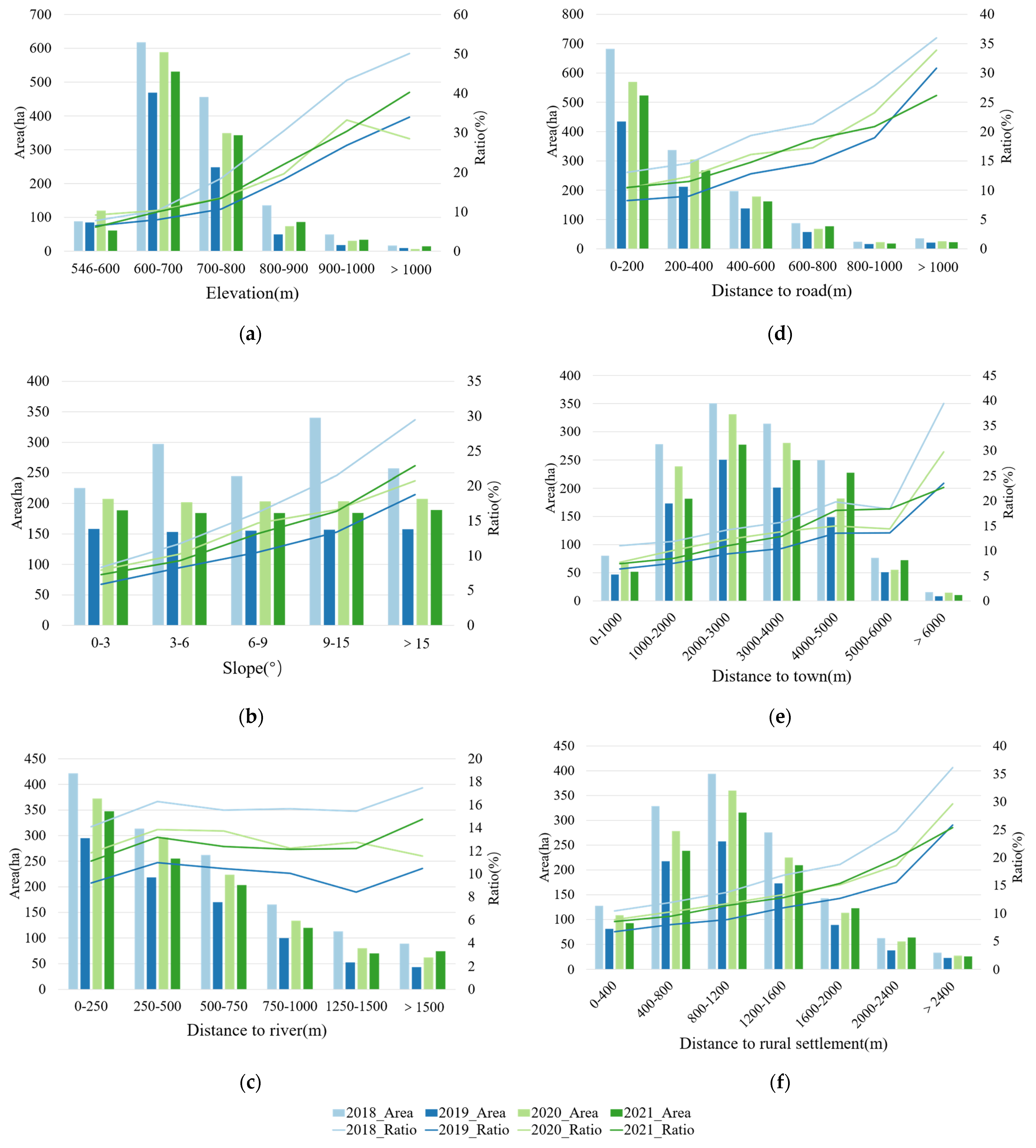
3.2.2. Spatial–Temporal Characteristics of Abandoned Cropland under Different Natural and Social Factors
3.3. Driving Factors of Cropland Abandonment
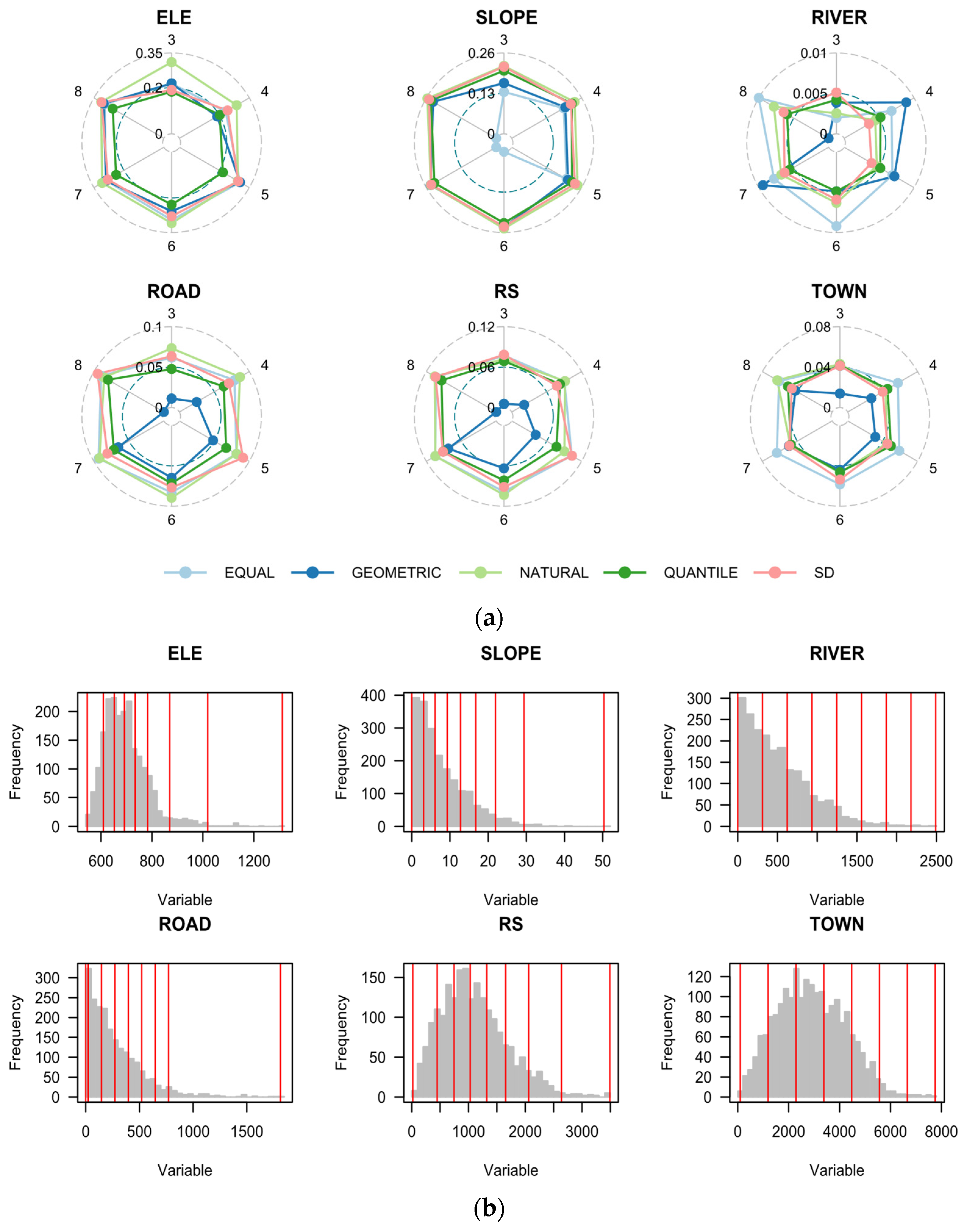
3.3.1. Discretization of Continuous Factors
3.3.2. Single Factor Detection Results
3.3.3. Interaction Detection Results
4. Discussion
4.1. Mapping Cropland Abandonment in Cloudy Hilly Regions
4.2. Spatial–Temporal Characteristics and Driving Factors of Cropland Abandonment
4.3. Policy Implications
4.4. Limitations and Future Research Perspectives
5. Conclusions
Author Contributions
Funding
Data Availability Statement
Acknowledgments
Conflicts of Interest
References
- Li, S.; Li, X. Global understanding of farmland abandonment: A review and prospects. J. Geogr. Sci. 2017, 27, 1123–1150. [Google Scholar] [CrossRef]
- Kuntz, K.A.; Beaudry, F.; Porter, K.L. Farmers’ Perceptions of Agricultural Land Abandonment in Rural Western New York State. Land 2018, 7, 128. [Google Scholar] [CrossRef]
- Renwick, A.; Jansson, T.; Verburg, P.H.; Revoredo-Giha, C.; Britz, W.; Gocht, A.; McCracken, D. Policy reform and agricultural land abandonment in the EU. Land Use Policy 2013, 30, 446–457. [Google Scholar] [CrossRef]
- Yin, H.; Brandão, A.; Buchner, J.; Helmers, D.; Iuliano, B.G.; Kimambo, N.E.; Lewińska, K.E.; Razenkova, E.; Rizayeva, A.; Rogova, N.; et al. Monitoring cropland abandonment with Landsat time series. Remote Sens. Environ. 2020, 246, 111873. [Google Scholar] [CrossRef]
- Hatna, E.; Bakker, M.M. Abandonment and Expansion of Arable Land in Europe. Ecosystems 2011, 14, 720–731. [Google Scholar] [CrossRef]
- Brown, D.G.; Johnson, K.M.; Loveland, T.R.; Theobald, D.M. RURAL LAND-USE TRENDS IN THE CONTERMINOUS UNITED STATES, 1950–2000. Ecol. Appl. 2005, 15, 1851–1863. [Google Scholar] [CrossRef]
- Su, G.; Okahashi, H.; Chen, L. Spatial Pattern of Farmland Abandonment in Japan: Identification and Determinants. Sustainability 2018, 10, 3676. [Google Scholar] [CrossRef]
- Wang, C.; Gao, Q.; Wang, X.; Yu, M. Decadal Trend in Agricultural Abandonment and Woodland Expansion in an Agro-Pastoral Transition Band in Northern China. PLoS ONE 2015, 10, e0142113. [Google Scholar] [CrossRef] [PubMed]
- Chaudhary, S.; Wang, Y.; Dixit, A.M.; Khanal, N.R.; Xu, P.; Fu, B.; Yan, K.; Liu, Q.; Lu, Y.; Li, M. A Synopsis of Farmland Abandonment and Its Driving Factors in Nepal. Land 2020, 9, 84. [Google Scholar] [CrossRef]
- Baumann, M.; Kuemmerle, T.; Elbakidze, M.; Ozdogan, M.; Radeloff, V.C.; Keuler, N.S.; Prishchepov, A.V.; Kruhlov, I.; Hostert, P. Patterns and drivers of post-socialist farmland abandonment in Western Ukraine. Land Use Policy 2011, 28, 552–562. [Google Scholar] [CrossRef]
- Lambin, E.F.; Meyfroidt, P. Land use transitions: Socio-ecological feedback versus socio-economic change. Land Use Policy 2010, 27, 108–118. [Google Scholar] [CrossRef]
- Zhang, Y.; Li, X.; Song, W. Determinants of cropland abandonment at the parcel, household and village levels in mountain areas of China: A multi-level analysis. Land Use Policy 2014, 41, 186–192. [Google Scholar] [CrossRef]
- Wang, Y.; Song, W. Mapping Abandoned Cropland Changes in the Hilly and Gully Region of the Loess Plateau in China. Land 2021, 10, 1341. [Google Scholar] [CrossRef]
- Knoke, T.; Calvas, B.; Moreno, S.O.; Onyekwelu, J.C.; Griess, V.C. Food production and climate protection—What abandoned lands can do to preserve natural forests. Glob. Environ. Chang. 2013, 23, 1064–1072. [Google Scholar] [CrossRef]
- Raj Khanal, N.; Watanabe, T. Abandonment of Agricultural Land and Its Consequences. Mt. Res. Dev. 2006, 26, 32–40. [Google Scholar] [CrossRef]
- Han, Z.; Song, W. Spatiotemporal variations in cropland abandonment in the Guizhou–Guangxi karst mountain area, China. J. Clean. Prod. 2019, 238, 117888. [Google Scholar] [CrossRef]
- He, S.; Shao, H.; Xian, W.; Zhang, S.; Zhong, J.; Qi, J. Extraction of Abandoned Land in Hilly Areas Based on the Spatio-Temporal Fusion of Multi-Source Remote Sensing Images. Remote Sens. 2021, 13, 3956. [Google Scholar] [CrossRef]
- Hong, C.; Prishchepov, A.V.; Jin, X.; Han, B.; Lin, J.; Liu, J.; Ren, J.; Zhou, Y. The role of harmonized Landsat Sentinel-2 (HLS) products to reveal multiple trajectories and determinants of cropland abandonment in subtropical mountainous areas. J. Environ. Manag. 2023, 336, 117621. [Google Scholar] [CrossRef] [PubMed]
- Xu, F.; Ho, H.C.; Chi, G.; Wang, Z. Abandoned rural residential land: Using machine learning techniques to identify rural residential land vulnerable to be abandoned in mountainous areas. Habitat Int. 2019, 84, 43–56. [Google Scholar] [CrossRef]
- MacDonald, D.; Crabtree, J.R.; Wiesinger, G.; Dax, T.; Stamou, N.; Fleury, P.; Gutierrez Lazpita, J.; Gibon, A. Agricultural abandonment in mountain areas of Europe: Environmental consequences and policy response. J. Environ. Manag. 2000, 59, 47–69. [Google Scholar] [CrossRef]
- Zhang, Y.; Min, Q.; Zhang, C.; He, L.; Zhang, S.; Yang, L.; Tian, M.; Xiong, Y. Traditional culture as an important power for maintaining agricultural landscapes in cultural heritage sites: A case study of the Hani terraces. J. Cult. Herit. 2017, 25, 170–179. [Google Scholar] [CrossRef]
- Yan, J.; Yang, Z.; Li, Z.; Li, X.; Xin, L.; Sun, L. Drivers of cropland abandonment in mountainous areas: A household decision model on farming scale in Southwest China. Land Use Policy 2016, 57, 459–469. [Google Scholar] [CrossRef]
- Shi, T.; Li, X.; Xin, L.; Xu, X. The spatial distribution of farmland abandonment and its influential factors at the township level: A case study in the mountainous area of China. Land Use Policy 2018, 70, 510–520. [Google Scholar] [CrossRef]
- Prishchepov, A.V.; Müller, D.; Dubinin, M.; Baumann, M.; Radeloff, V.C. Determinants of agricultural land abandonment in post-Soviet European Russia. Land Use Policy 2013, 30, 873–884. [Google Scholar] [CrossRef]
- Meyfroidt, P. Approaches and terminology for causal analysis in land systems science. J. Land Use Sci. 2016, 11, 501–522. [Google Scholar] [CrossRef]
- Zaragozí, B.; Rabasa, A.; Rodríguez-Sala, J.J.; Navarro, J.T.; Belda, A.; Ramón, A. Modelling farmland abandonment: A study combining GIS and data mining techniques. Agric. Ecosyst. Environ. 2012, 155, 124–132. [Google Scholar] [CrossRef]
- Estel, S.; Kuemmerle, T.; Alcántara, C.; Levers, C.; Prishchepov, A.; Hostert, P. Mapping farmland abandonment and recultivation across Europe using MODIS NDVI time series. Remote Sens. Environ. 2015, 163, 312–325. [Google Scholar] [CrossRef]
- Alcantara, C.; Kuemmerle, T.; Baumann, M.; Bragina, E.V.; Griffiths, P.; Hostert, P.; Knorn, J.; Müller, D.; Prishchepov, A.V.; Schierhorn, F.; et al. Mapping the extent of abandoned farmland in Central and Eastern Europe using MODIS time series satellite data. Environ. Res. Lett. 2013, 8, 035035. [Google Scholar] [CrossRef]
- De Fries, R.S.; Hansen, M.; Townshend, J.R.G.; Sohlberg, R. Global land cover classifications at 8 km spatial resolution: The use of training data derived from Landsat imagery in decision tree classifiers. Int. J. Remote Sens. 1998, 19, 3141–3168. [Google Scholar] [CrossRef]
- Dara, A.; Baumann, M.; Kuemmerle, T.; Pflugmacher, D.; Rabe, A.; Griffiths, P.; Hölzel, N.; Kamp, J.; Freitag, M.; Hostert, P. Mapping the timing of cropland abandonment and recultivation in northern Kazakhstan using annual Landsat time series. Remote Sens. Environ. 2018, 213, 49–60. [Google Scholar] [CrossRef]
- Yin, H.; Prishchepov, A.V.; Kuemmerle, T.; Bleyhl, B.; Buchner, J.; Radeloff, V.C. Mapping agricultural land abandonment from spatial and temporal segmentation of Landsat time series. Remote Sens. Environ. 2018, 210, 12–24. [Google Scholar] [CrossRef]
- Prishchepov, A.V.; Radeloff, V.C.; Dubinin, M.; Alcantara, C. The effect of Landsat ETM/ETM+ image acquisition dates on the detection of agricultural land abandonment in Eastern Europe. Remote Sens. Environ. 2012, 126, 195–209. [Google Scholar] [CrossRef]
- Immitzer, M.; Vuolo, F.; Atzberger, C. First Experience with Sentinel-2 Data for Crop and Tree Species Classifications in Central Europe. Remote Sens. 2016, 8, 166. [Google Scholar] [CrossRef]
- Gorelick, N.; Hancher, M.; Dixon, M.; Ilyushchenko, S.; Thau, D.; Moore, R. Google Earth Engine: Planetary-scale geospatial analysis for everyone. Remote Sens. Environ. 2017, 202, 18–27. [Google Scholar] [CrossRef]
- dos Santos, E.P.; da Silva, D.D.; do Amaral, C.H.; Fernandes-Filho, E.I.; Dias, R.L.S. A Machine Learning approach to reconstruct cloudy affected vegetation indices imagery via data fusion from Sentinel-1 and Landsat 8. Comput. Electron. Agric. 2022, 194, 106753. [Google Scholar] [CrossRef]
- Zhang, X.; Wu, B.; Ponce-Campos, G.E.; Zhang, M.; Chang, S.; Tian, F. Mapping up-to-Date Paddy Rice Extent at 10 M Resolution in China through the Integration of Optical and Synthetic Aperture Radar Images. Remote Sens. 2018, 10, 1200. [Google Scholar] [CrossRef]
- Zanaga, D.; Van De Kerchove, R.; De Keersmaecker, W.; Souverijns, N.; Brockmann, C.; Quast, R.; Wevers, J.; Grosu, A.; Paccini, A.; Vergnaud, S.; et al. ESA WorldCover 10 m 2020 v100. Available online: https://data.apps.fao.org/catalog/dataset/378e9df5-3814-4a80-bb47-e25df0543634 (accessed on 25 April 2024).
- Karra, K.; Kontgis, C.; Statman-Weil, Z.; Mazzariello, J.C.; Mathis, M.; Brumby, S.P. Global land use/land cover with Sentinel 2 and deep learning. In Proceedings of the 2021 IEEE International Geoscience and Remote Sensing Symposium IGARSS, Brussels, Belgium, 11–16 July 2021; pp. 4704–4707. [Google Scholar]
- Zhang, X.; Liu, L.; Chen, X.; Gao, Y.; Xie, S.; Mi, J. GLC_FCS30: Global land-cover product with fine classification system at 30 m using time-series Landsat imagery. Earth Syst. Sci. Data 2021, 13, 2753–2776. [Google Scholar] [CrossRef]
- Yang, J.; Huang, X. The 30 m annual land cover dataset and its dynamics in China from 1990 to 2019. Earth Syst. Sci. Data 2021, 13, 3907–3925. [Google Scholar] [CrossRef]
- Rouse, J.W.; Haas, R.H.; Schell, J.A.; Deering, D.W. Monitoring vegetation systems in the great plains with ERTS. NASA Spec. Publ. 1973, 351, 309. [Google Scholar]
- Olsen, V.M.; Fensholt, R.; Olofsson, P.; Bonifacio, R.; Butsic, V.; Druce, D.; Ray, D.; Prishchepov, A.V. The impact of conflict-driven cropland abandonment on food insecurity in South Sudan revealed using satellite remote sensing. Nat. Food 2021, 2, 990–996. [Google Scholar] [CrossRef]
- Eklund, L.; Degerald, M.; Brandt, M.; Prishchepov, A.; Pilesjö, P. How conflict affects land use: Agricultural activity in areas seized by the Islamic State. Environ. Res. Lett. 2017, 12, 054004. [Google Scholar] [CrossRef]
- Inglada, J.; Vincent, A.; Arias, M.; Marais-Sicre, C. Improved Early Crop Type Identification By Joint Use of High Temporal Resolution SAR And Optical Image Time Series. Remote Sens. 2016, 8, 362. [Google Scholar] [CrossRef]
- Van Tricht, K.; Gobin, A.; Gilliams, S.; Piccard, I. Synergistic use of radar Sentinel-1 and optical Sentinel-2 imagery for crop mapping: A case study for Belgium. Remote Sens. 2018, 10, 1642. [Google Scholar] [CrossRef]
- dos Santos, E.P.; Da Silva, D.D.; do Amaral, C.H. Vegetation cover monitoring in tropical regions using SAR-C dual-polarization index: Seasonal and spatial influences. Int. J. Remote Sens. 2021, 42, 7581–7609. [Google Scholar] [CrossRef]
- Frison, P.-L.; Fruneau, B.; Kmiha, S.; Soudani, K.; Dufrene, E.; Le Toan, T.; Koleck, T.; Villard, L.; Mougin, E.; Rudant, J.-P. Potential of Sentinel-1 Data for Monitoring Temperate Mixed Forest Phenology. Remote Sens. 2018, 10, 2049. [Google Scholar] [CrossRef]
- Hird, J.N.; DeLancey, E.R.; McDermid, G.J.; Kariyeva, J. Google Earth Engine, Open-Access Satellite Data, and Machine Learning in Support of Large-Area Probabilistic Wetland Mapping. Remote Sens. 2017, 9, 1315. [Google Scholar] [CrossRef]
- Nasirzadehdizaji, R.; Balik Sanli, F.; Abdikan, S.; Cakir, Z.; Sekertekin, A.; Ustuner, M. Sensitivity Analysis of Multi-Temporal Sentinel-1 SAR Parameters to Crop Height and Canopy Coverage. Appl. Sci. 2019, 9, 655. [Google Scholar] [CrossRef]
- Zhou, J.; Jia, L.; Menenti, M. Reconstruction of global MODIS NDVI time series: Performance of Harmonic ANalysis of Time Series (HANTS). Remote Sens. Environ. 2015, 163, 217–228. [Google Scholar] [CrossRef]
- Jordan, C.F. Derivation of Leaf-Area Index from Quality of Light on the Forest Floor. Ecology 1969, 50, 663–666. [Google Scholar] [CrossRef]
- Rikimaru, A.; Roy, P.S.; Miyatake, S. Tropical forest cover density mapping. Trop. Ecol. 2002, 43, 39–47. [Google Scholar]
- Kolluru, V.; John, R.; Saraf, S.; Chen, J.; Hankerson, B.; Robinson, S.; Kussainova, M.; Jain, K. Gridded livestock density database and spatial trends for Kazakhstan. Sci. Data 2023, 10, 839. [Google Scholar] [CrossRef] [PubMed]
- Cramer, V.A.; Hobbs, R.J.; Standish, R.J. What’s new about old fields? Land abandonment and ecosystem assembly. Trends Ecol. Evol. 2008, 23, 104–112. [Google Scholar] [CrossRef] [PubMed]
- Prishchepov, A.V.; Schierhorn, F.; Löw, F. Unraveling the Diversity of Trajectories and Drivers of Global Agricultural Land Abandonment. Land 2021, 10, 97. [Google Scholar] [CrossRef]
- Wang, J.-F.; Zhang, T.-L.; Fu, B.-J. A measure of spatial stratified heterogeneity. Ecol. Indic. 2016, 67, 250–256. [Google Scholar] [CrossRef]
- Song, Y.; Wang, J.; Ge, Y.; Xu, C. An optimal parameters-based geographical detector model enhances geographic characteristics of explanatory variables for spatial heterogeneity analysis: Cases with different types of spatial data. GIScience Remote Sens. 2020, 57, 593–610. [Google Scholar] [CrossRef]
- Venkatesh, K.; John, R.; Chen, J.; Xiao, J.; Amirkhiz, R.G.; Giannico, V.; Kussainova, M. Optimal ranges of social-environmental drivers and their impacts on vegetation dynamics in Kazakhstan. Sci. Total Environ. 2022, 847, 157562. [Google Scholar] [CrossRef] [PubMed]
- Li, H.; Song, W. Cropland Abandonment and Influencing Factors in Chongqing, China. Land 2021, 10, 1206. [Google Scholar] [CrossRef]
- Alcantara, C.; Kuemmerle, T.; Prishchepov, A.V.; Radeloff, V.C. Mapping abandoned agriculture with multi-temporal MODIS satellite data. Remote Sens. Environ. 2012, 124, 334–347. [Google Scholar] [CrossRef]
- Queiroz, C.; Beilin, R.; Folke, C.; Lindborg, R. Farmland abandonment: Threat or opportunity for biodiversity conservation? A global review. Front. Ecol. Environ. 2014, 12, 288–296. [Google Scholar] [CrossRef] [PubMed]
- Qiu, B.; Yang, X.; Tang, Z.; Chen, C.; Li, H.; Berry, J. Urban expansion or poor productivity: Explaining regional differences in cropland abandonment in China during the early 21st century. Land Degrad. Dev. 2020, 31, 2540–2551. [Google Scholar] [CrossRef]
- Bai, M.; Zhou, S.; Tang, T. A Reconstruction of Irrigated Cropland Extent in China from 2000 to 2019 Using the Synergy of Statistics and Satellite-Based Datasets. Land 2022, 11, 1686. [Google Scholar] [CrossRef]
- Ding, S.; Li, M.; Wang, X.; Li, L.; Wu, R.; Huang, H. The Use of Time Series Remote Sensing Data to Analyze the Characteristics of Non-agriculture Farmland and Their Driving Factors in Fuzhou. Remote Sens. Technol. Appl. 2022, 37, 550–563. [Google Scholar] [CrossRef]
- Jiang, C.; Song, W. Degree of Abandoned Cropland and Socioeconomic Impact Factors in China: Multi-Level Analysis Model Based on the Farmer and District/County Levels. Land 2022, 11, 8. [Google Scholar] [CrossRef]
- Wang, X.; Zhao, D. Study on the Causes of Differences in Cropland Abandonment Levels among Farming Households Based on Hierarchical Linear Model—13,120 Farming Households in 26 Provinces of China as an Example. Land 2023, 12, 1791. [Google Scholar] [CrossRef]
- Jin, X.; Xiang, X.; Guan, X.; Wu, X.; Bai, Q.; Zhou, Y. Assessing the relationship between the spatial distribution of land consolidation projects and farmland resources in China, 2006–2012. Food Secur. 2017, 9, 889–905. [Google Scholar] [CrossRef]
- Hong, C.; Jin, X.; Fan, Y.; Xiang, X.; Cao, S.; Chen, C.; Zheng, G.; Zhou, Y. Determining the effect of land consolidation on agricultural production using a novel assessment framework. Land Degrad. Dev. 2020, 31, 356–371. [Google Scholar] [CrossRef]
- Guo, A.; Yue, W.; Yang, J.; Xue, B.; Xiao, W.; Li, M.; He, T.; Zhang, M.; Jin, X.; Zhou, Q. Cropland abandonment in China: Patterns, drivers, and implications for food security. J. Clean. Prod. 2023, 418, 138154. [Google Scholar] [CrossRef]


| Product | Satellites | Temporal Resolution | Spatial Resolution | Selected Bands | Level of Correction |
|---|---|---|---|---|---|
| Sentinel-1 SAR, IW | Sentinel-1A and -1B | 6 days | 10 m | VV and VH | GRD |
| Sentinel-2 MSI, L1A | Sentinel-2A and -2B | 5 days | 10–20 m | VNIR and SWIR | TOA |
| Landsat 8 Tier 1 | Landsat 8 | 16 days | 30 m | VNIR and SWIR | TOA |
| Class | 2018 | 2019 | 2020 | 2021 | 2022 | Combined |
|---|---|---|---|---|---|---|
| Cropland | 122 | 126 | 121 | 121 | 123 | 613 |
| Garden land | 80 | 80 | 80 | 80 | 80 | 400 |
| Shrubland | 83 | 85 | 83 | 83 | 84 | 418 |
| Forest | 100 | 100 | 100 | 100 | 100 | 500 |
| Water | 42 | 45 | 42 | 43 | 42 | 214 |
| Built-up | 83 | 86 | 83 | 83 | 84 | 419 |
| Total | 510 | 522 | 509 | 510 | 513 | 2564 |
| Class | Area (%) | ||||
|---|---|---|---|---|---|
| 2018 | 2019 | 2020 | 2021 | 2022 | |
| Cropland | 20.29 | 19.41 | 19.81 | 19.15 | 20.88 |
| Garden land | 31.37 | 31.26 | 31.25 | 31.29 | 29.65 |
| Shrubland | 6.81 | 6.85 | 6.68 | 6.64 | 5.86 |
| Forest | 29.46 | 29.67 | 27.96 | 27.40 | 27.62 |
| Water | 1.94 | 2.13 | 2.59 | 2.52 | 2.54 |
| Built-up | 10.13 | 10.68 | 11.71 | 13.01 | 13.46 |
| Class | 2018 | 2019 | 2020 | 2021 | 2022 | |||||
|---|---|---|---|---|---|---|---|---|---|---|
| UA | PA | UA | PA | UA | PA | UA | PA | UA | PA | |
| /% | /% | /% | /% | /% | /% | /% | /% | /% | /% | |
| Cropland | 91.19 | 91.74 | 87.34 | 88.11 | 87.87 | 88.61 | 91.92 | 92.44 | 89.61 | 90.25 |
| Garden land | 84.51 | 88.24 | 83.94 | 87.79 | 83.33 | 87.30 | 85.53 | 89.04 | 85.81 | 89.26 |
| Shrubland | 89.07 | 89.80 | 88.11 | 88.89 | 88.61 | 89.36 | 88.84 | 89.58 | 88.80 | 89.54 |
| Forest | 91.74 | 87.72 | 90.91 | 86.54 | 89.89 | 85.11 | 92.11 | 88.24 | 92.14 | 88.28 |
| Water | 95.54 | 94.94 | 95.24 | 94.59 | 94.49 | 93.75 | 95.81 | 95.24 | 95.48 | 94.87 |
| Built-up | 89.29 | 90.09 | 90.16 | 90.91 | 88.24 | 89.11 | 90.91 | 91.60 | 88.79 | 89.62 |
| OA/% | 90.46 | 89.15 | 88.67 | 91.02 | 90.14 | |||||
| Kappa | 0.88 | 0.87 | 0.86 | 0.89 | 0.88 | |||||
Disclaimer/Publisher’s Note: The statements, opinions and data contained in all publications are solely those of the individual author(s) and contributor(s) and not of MDPI and/or the editor(s). MDPI and/or the editor(s) disclaim responsibility for any injury to people or property resulting from any ideas, methods, instructions or products referred to in the content. |
© 2024 by the authors. Licensee MDPI, Basel, Switzerland. This article is an open access article distributed under the terms and conditions of the Creative Commons Attribution (CC BY) license (https://creativecommons.org/licenses/by/4.0/).
Share and Cite
Wei, Y.; Wen, J.; Zhou, Q.; Zhang, Y.; Dong, G. Mapping Cropland Abandonment in the Cloudy Hilly Regions Surrounding the Southwest Basin of China. Land 2024, 13, 586. https://doi.org/10.3390/land13050586
Wei Y, Wen J, Zhou Q, Zhang Y, Dong G. Mapping Cropland Abandonment in the Cloudy Hilly Regions Surrounding the Southwest Basin of China. Land. 2024; 13(5):586. https://doi.org/10.3390/land13050586
Chicago/Turabian StyleWei, Yali, Junjie Wen, Qunchao Zhou, Yan Zhang, and Gaocheng Dong. 2024. "Mapping Cropland Abandonment in the Cloudy Hilly Regions Surrounding the Southwest Basin of China" Land 13, no. 5: 586. https://doi.org/10.3390/land13050586
APA StyleWei, Y., Wen, J., Zhou, Q., Zhang, Y., & Dong, G. (2024). Mapping Cropland Abandonment in the Cloudy Hilly Regions Surrounding the Southwest Basin of China. Land, 13(5), 586. https://doi.org/10.3390/land13050586