Abstract
The easy implementation of a nature-based solution (NBS) to address a prompt stabilisation of burnt areas may be crucial in the Mediterranean forest environment. A plot scale hydrological and ecological survey was conducted in a pine forest of the Aspromonte Massif (southern Italy) affected by a high fire severity in summer 2021. The hydrological response to 30 rainfall event groups is analysed by monitoring nine sloping plots distributed into three plot blocks (forested according to the pre-fire situation, burnt with randomly directed felled logs and burnt with manually felled logs redirected along contour lines). The hydrological response of bare soil is mitigated by about 30% through the combined effects of the NBS and the vegetation cover by pioneer species. Although the regeneration of Pinus radiata is scarcer in the arranged plots, the spontaneous vegetation, once gone, prepares better edaphic conditions for the triggering of forest dynamics assured by the auto-succession of Pinus radiata. In terms of woody mechanical resistance, NBS durability is compatible with the time required for seedlings to regenerate the forest ecosystem. The results achieved so far encourage further research on higher slopes and complementary aspects (vegetal and animal biodiversity, economic factors, etc.).
1. Introduction
Wildfires in the Mediterranean environment have always been a crucial factor for forest ecosystem protection and regeneration [1,2,3,4]. Since the second half of the last century, concurrently with the depopulation of rural areas and the abandonment of land management practices as well as the expansion of the forest–urban interface, the frequency, size and magnitude of this phenomenon have increased significantly [5,6].
In Europe, in the last few decades, about 65,000 fires per year have affected a forested area of about 500,000 ha. Over 95% of fires in the Mediterranean basin are caused by humans, with extreme events increasingly (every 2–3 years) often showing extraordinary characteristics in terms of size and complexity, as occurred in Italy in 2021 within an area of more than 10,000 ha in a single episode [7,8,9].
A high-intensity/-severity wildfire drastically modifies forest structure [10,11,12,13,14,15], biodiversity and species composition [16,17,18] and alters the physico-chemical properties of the soil [19,20,21,22]; moreover, the drastic reduction in vegetation exacerbates the hydrological response and the related risks [23,24,25,26,27]. Therefore, the rapid and extensive change in land use by extreme wildfires represents both an ecological and environmental problem, particularly in the morphologically complex territories of the Mediterranean basin, where large areas are prone to instability phenomena [28,29]. Furthermore, the protection and function of the Mediterranean scrub are also compromised when it is affected by fire and is no longer able to provide its important resources in terms of ecosystem services [30].
As is well known, forest typology, structure and composition can influence the ecosystem exposure to wildfires. For example, reforestation by monospecific species, especially if not properly managed, represents one of the most vulnerable conditions. Large mountain areas in the Mediterranean basin have been artificially reforested, in particular with conifers [31], in order to mitigate the hydrogeological instability. In most cases, these forest stands were abandoned and no silvicultural treatment was applied. Today, they are often characterised by low levels of ecological functionality and resilience [32]; moreover, the marked tree density makes the woody mass more vulnerable to wildfires and other external disturbances, particularly in a global change scenario [33].
The Calabria region (southern Italy) where the present investigation was carried out, represents an interesting case study, as it combines several critical factors representing one of the highest levels of vulnerability in the Mediterranean area: the widespread presence of artificial coniferous forest (about 150,000 hectares of reforestation), a worrying increase in the phenomenon of forest fires of anthropic origin, a peculiar rainfall regime (intense rain events typical of the so-called semi-arid Mediterranean climate) and a geo-lithological and tectonic predisposition to instability.
Restoration of fire-affected forests is a very complex and expensive operation [34,35]. Moreover, in Italy, forest fire regulations drastically limit remediation works with public funds (Law No. 353/2000). Natural regeneration, on the other hand, takes a very long time and is not compatible with the immediate need to protect the bare soil [23,24,25,26,27,36]. In the Mediterranean climatic environment, moreover, the removal of the forest due to fire is compounded by the disappearance of herbaceous vegetation due to the long dry period, thus exposing the uncovered soil to erosive processes [5,37,38,39,40,41,42,43,44], especially coinciding with the first heavy autumn rains [5]. Some authors demonstrated that the reduction in tree cover caused by fires increases runoff and sediment production from 1 to 4 orders of magnitude [5,45,46,47,48,49,50,51].
Therefore, a non-invasive and compliant naturalistic technique should be advisable both to stabilise slopes and accelerate the start of natural regeneration to restore the protective function of the forest as soon as possible [36]. For this reason, the use of nature-based solutions appears appropriate to restore physical, biological and ecological processes valorising an integral approach to the ecosystem restoration. Nature-based solutions may be low-cost, minimise the procedures for their implementation and maintenance and do not have environmental impact [52,53,54]. These aspects make the nature-based solution suitable and easy to implement even in the case of legal restrictions. In short, the “bioengineering techniques” that utilise inert natural material (e.g., stones and wood) to favour the short-term establishment of the living biological component (e.g., vegetation) are further enriched in meaning as they provide ecosystem services. In this perspective, many investigations have shown the effectiveness of the log erosion barriers (LEBs) in the Mediterranean environment [5,6,21,37,38,39,40,41,42,43,44,55,56,57].
However, most studies, by focusing mainly on only one aspect (e.g., soil erosion or vegetation response separately), highlight the need for in-depth multidisciplinary approaches aimed at investigating the effects of measures on the whole ecosystem in order to understand the dynamics that govern ecological functionality and resilience in terms of the self-regeneration capacity. A first attempt was undertaken by Bombino et al. [58] in the Aspromonte Massif (southern Calabria), demonstrating a significant reduction in runoff and sediment yield by using in situ collapsed burnt trees, manually redirected along the contour lines immediately after the extreme event; the hydrologic study is also integrated with some preliminary observations on the regeneration capacity of the forest.
In relation to the above, in order to integrate and extend over time the preliminary hydrological observation carried out in the Aspromonte Massif and, on the other hand, to extend the investigation to the other relevant ecological and technical aspects, the present work pursues the following aims:
- -
- to confirm the effectiveness of the in situ use of collapsed burnt logs manually redirected to reduce the slope and the hydrological response, in order to quickly counteract the triggering of erosion phenomena (short-term effect);
- -
- to assess, more than 2 years after its implementation, the effects of the naturalistic measure on the self-regenerative dynamics of the forest ecosystem, in order to restore the maximum ecological and protective functionality of the woodland over time (long-term effect);
- -
- to evaluate the durability of the wood barriers also for their implementation in the bioengineering field, in order to test how long the structural function of the measure can be prolonged before the forest becomes established;
- -
- to deepen the regulatory aspects concerning the practicability of the remediation measure.
2. Materials and Methods
The logical path in the survey approach is illustrated in Figure 1. According to the aims of the work and in order to verify the effectiveness of the measure, the various actions have both short- and long-term implications, as separated by the dotted line. The activities for which preliminary results have already been obtained (one year after the event, 2022) are shown in the grey boxes; in the present work, they have been further monitored covering an additional year of observation in continuity with the methodologies already available. The new investigations planned to give an integrated and multidisciplinary approach to the investigation are, instead, highlighted by the yellow boxes.
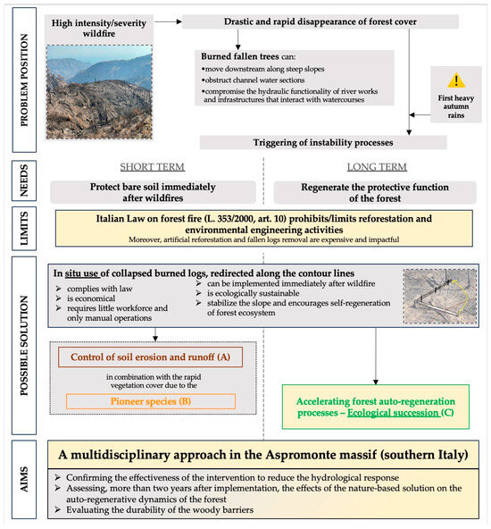
Figure 1.
Conceptual–logical scheme used to articulate the work, illustrating the critical issues and opportunities associated with the use of in situ felled burnt logs for ecosystem regeneration.
Overall, the activity involved the following steps:
- -
- description of the study area and characterisation of the extreme wildfire event that occurred in 2021 in the Aspromonte Massif;
- -
- description and characterisation of the experimental site;
- -
- collection and elaboration of data concerning (i) forest regeneration, (ii) hydrological response (runoff and sediment yields) and (iii) biotechnical and worksite aspects.
2.1. Characterisation of Extreme Wildfire Event That Occurred in 2021 in the Aspromonte Massif
In the present study, the term “extreme wildfire” refers to an event with high severity, affecting the highest forest plane and causing 80–100% of the crowns to be scorched [59,60]. Calabria is a peninsula-shaped region located at the southernmost part of Italy, with 90% of territory being mountainous or hilly. The territory, due to its peculiar geo-lithological, morphological and climatic characteristics, is among the most vulnerable and unstable in the Mediterranean basin [58,61,62,63]. From the climatic point of view, the mountainous areas, located a short distance from the sea, have a typical climate with frequent snow during the winter. The coastal areas have a Mediterranean climate: the Tyrrhenian coast (along the west) is mainly exposed to the winds of the Mistral (North–West) and is cooler and rainier than the Ionian one (east coast), which is mainly exposed to the winds of Scirocco (South–East) and Gregale (North–East).
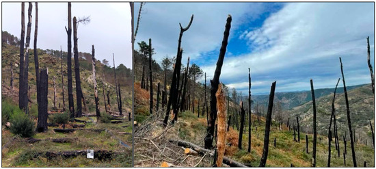
To the south of Calabria rises the Aspromonte Massif, much of which falls within the protected area of the National Park. A large area of Aspromonte National Park (ANP) was affected by a huge fire season in August 2021: in approximately 10 days more than five thousand hectares of forest was burnt. In the area where our experimental plots are located (see next paragraph Section 2.2), a high fire severity has been recorded, with crown scorch from 80% to 100% (Scheme 1a) [58,64]. More details about severity mapping in Aspromonte Massif area can be found in an already published paper by one of the authors of this manuscript [65]. The area under study had never been affected by severe fires, although in the surrounding mountain zones (also in the Roccaforte del Greco district), only in 2012, an event of equal severity to that of 2021 burnt approximately 1000 hectares of forest (always an artificial pine forest). Unfortunately, in the last decades, severe fires in Aspromonte Massif are becoming more and more frequent, with a recurrence of 5–7 years.
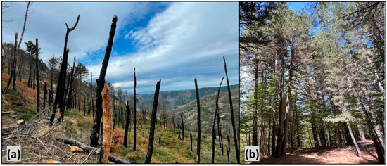
Scheme 1.
Representative photos of (a) the Aspromonte areas affected by the wildfires of summer 2021 and (b) the high density of Pinus radiata forest in Aspromonte.
Within the present investigation, the following methodology was used to map and quantify the surface affected by fire event. Satellite images and spectral indices were used for this purpose. Among the different available spectral indices, the Normalised Burn Ratio (NBR) [66] is widely recognised as effective in discriminating burnt areas [67,68,69,70]. Considering that fire events were concentrated in the first ten days of August 2021, we examined the fire events, through the code editor environment of the Google Earth Engine (GEE) cloud computational platform [71], one cloud-free Sentinel-2 satellite image before (i.e., 8 July 2021) and one after (16 September 2021). For each image, still in GEE environment, we calculated the NBR index as follow (Equation (1)):
(NIRρ842 − SWIRρ2190)/(NIRρ842 + SWIRρ2190)
The two NBR indices maps, obtained for the pre-fire and post-fire images, were finally downloaded and imported in the free open-source software QGIS where the burnt areas were highlighted subtracting pre-fire NBR values from the post-fire ones. The burnt areas obtained were finally polygonised, obtaining a vector layer representing all the areas affected by the fire events occurring inside the Aspromonte National Park area for the investigated period. Moreover, in correspondence with the burnt areas in which the experimental plots were placed (see next paragraph Section 2.2), the vegetation regrowth was calculated using the difference in NBR values from images immediately post-fire and after one and two years. Regrowth maps were made following the classification proposed by Key and Benson [64,72].
The obtained vector layer with the burnt areas was overlaid with the protection zones of the National Park (defined by the Italian National Law no. 394 of the 6 December 1991) and with the layer reporting the real vegetation information.
In particular, a total surface of 5589.27 ha was damaged by fire (Figure 2): 1319.81 ha within the so-called “A zone”, representing natural reserve areas; 1658.45 ha and 1961.73 ha for the lower protection zones B and C, respectively. Among the others, the fire mostly damaged natural pine forests of endemic black pines (886.46 ha; Pinus nigra J.F.Arnold subsp. laricio Palib. ex Maire). The mountain area, moreover, was subjected to several reforestation operations over the last 70 years; therefore, it is also characterised by a high density of artificial forest of Pinus nigra to which is added the Pinus radiata D. Don (800–1000 per ha with a height ranging from 14 to 20 m and crown diameters from 4 to 7.5 m), non-native species that have, however, become dominant (photo 1b) [58].
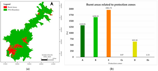
Figure 2.
Mapping of burnt areas (a) within the perimeter of the Aspromonte National Park and (b) in relation to protection zones according to the following zoning nomenclature: A—Strict nature reserve, no human activities allowed except for scientific research; B—General reserve, only traditional occupations are allowed, and tourism is overseen by the park; C—Planning of tourism and agro–silvo–pastoral systems authorised by the park; Cs—Special planning authorised by the park; D—Development areas, includes built-up areas, potentially sustainable activities; Ds—Special development areas.
2.2. Description and Characterisation of the Experimental Site
The experimental site is located in Roccaforte del Greco (970 m a.s.l., 38°03′ N; 15°54′ E, Figure 3) characterised by hot Mediterranean climate and semi-arid conditions [73], with mean temperatures of 5 °C in January and 23 °C in August, a mean annual rainfall depth of 1036 mm and monthly rainfall ranging between 13.7 mm in July and 153 mm in December [58].

Figure 3.
The study area located in Calabria, southern Italy.
The experimental site, implemented in September 2021 [58], consists of three plot blocks representative of the pre-fire conditions (Forested, F), the post-fire conditions with randomly felled logs (Burnt, B) and with contour-redirected downed logs simulating the so-called log erosion barriers (Burnt and Rearranged, BR). The pre-fire condition is represented by a mono-specific artificial reforestation of Pinus radiata D. Don. equal in age. As already mentioned, the area under study had never been affected by severe fires in the last 70 years, since the reforestation was carried out; as it has never been affected by silvicultural interventions, it has a high density (about 70 m2 ha−1). The average tree height is about 17 m, with an average crown diameter of about 5.3 m. This situation is representative of a wider mountainous area of the Aspromonte Massif affected by reforestation since the 1950s, when about 60,000 hectares were reforested (among others, with Pinus nigra subsp. Laricio and, indeed, Pinus radiata) to mitigate the disastrous hydrogeological instability that had affected the entire mountainous territory, causing damage, destruction and loss of life. The set-up and the characteristics of the sub-plots are summarised in Table 1.

Table 1.
Set-up of the plot blocks in Roccaforte del Greco (southern Calabria, Italy).
The field surveys were carried out within 17 months, starting one month after the end of the forest fires and before the autumn rains (September 2021) until January 2023. Bombino et al. [58] detected in the three plot blocks (through 27 soil samples within 5 cm topsoil, three per each sub-plot) the main physical–chemical characteristics of the soil: according to the USDA Soil Texture Classification System, the soil analysed falls into the category “sandy-loamy”, acid and poor in organic matter, with a high infiltration rate and a moderate aggregate stability.
2.3. Data Collection and Elaboration
2.3.1. Forest Regeneration Aspects
The quantification of natural regeneration of Pinus radiata was carried out one year after the wildfire (May and June 2022). Each sub-plot was divided into 22 rectangles of 5 m × 1 m; inside each rectangle, all seedlings born after the fire were counted and measured, recording their species and height. On the other hand, the vegetation cover of herbaceous/shrubby species within B and BR plot blocks was monitored over the time window (2021–2023) and the abundance–dominance index of each species [74] was evaluated by grid method [75], in continuity with the previous investigation of Bombino et al. [58].
2.3.2. Hydrological Aspects
According to the previous methodological approach [58], data on rainfall, runoff and sediment yields were collected and elaborated.
Rainfall data were recorded at the meteorological station in Roccaforte del Greco (about 3 km away from the experimental site) and summed (except in one case) to overcome the logistical limitation (distance and impervious mountain environment) that did not make it possible to follow the hydrological response after each single rainfall event group. The maximum rainfall intensity (mm h−1) within each event group was calculated. A total of 30 event groups were cumulated (six more than the previous observation, extending the time window from October 2022 to January 2023, Figure 4).
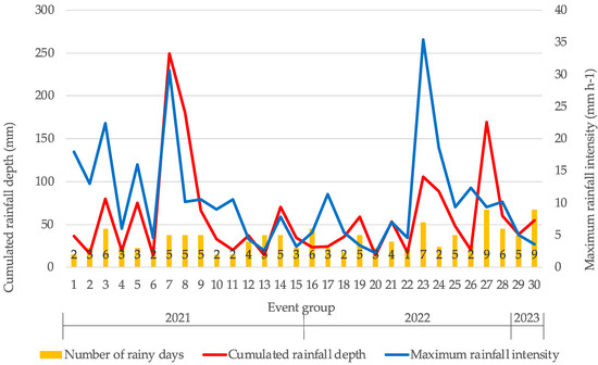
Figure 4.
Main of rainfall events recorded by the meteorological station located in Roccaforte del Greco, southern Calabria, Italy.
Runoff volume generated by each of the 30 event groups was collected and measured inside a tank located at the bottom of each sub-plot as shown in the scheme of Figure 5. At the same time, sediment dry weight immobilised in the gutter and the wet sediment concentration of the volume contained in the tank were sampled and treated [58,76], and finally added to obtain the total amount of sediment yield produced by each sub-plot.
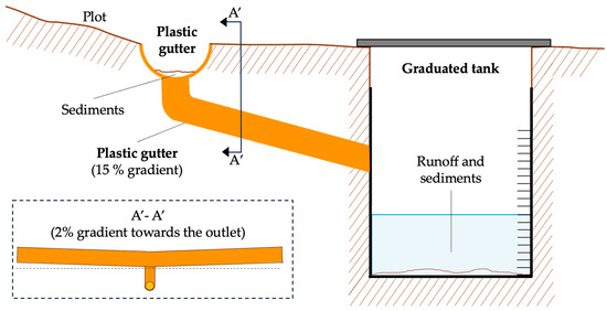
Figure 5.
Scheme of the collection system, for runoff and sediment, placed at the bottom of each sub-plot.
2.3.3. Biotechnical and Worksite Aspects
In order to evaluate whether the logs ensure their protective effect until the ecosystem is re-established, the in situ wood durability was evaluated by using two different non-destructive methods: (i) drilling resistance (DR) measurement by a resistograph© and (ii) acoustic stress wave techniques by using the microsecond timer device, adopted and tested to determine the initial state of the in situ felled burnt logs redirected along the contour lines. From the terminal section of each log, a wooden wheel was taken from which the density was obtained in the laboratory using the method described by the ISO standard 13061-2:2014.
In order to evaluate the durability of the wood over time, two measurements were repeated every six months, monitoring the density and velocity of propagation of acoustic waves in the logs. In particular, the DR test is an indirect way to assess the physical, mechanical and technological properties of wood [77,78,79,80,81]. The test was conducted in situ using an IML-Resi PD400 Resistograph (Instrumenta Mechanik Labor GmbH, Wiesloch, Germany) equipped with a 400 mm long and 3 mm thick steel drill (tip diameter 3 mm and shaft diameter 1.5 mm) [82]. The test has a high sensitivity for fungal decay and other wood defects [82,83] and can also be used to predict the density and other elastomechanical properties of wood [78,81,84,85,86,87], which are useful to evaluate the durability of wood. The Fakopp microsecond timer device (Fakopp Bt. Agfalva, Hungary), instead, uses the acoustic methodology [88] to evaluate the logs status, generating single-path stress waves on the trees with a transmission time with a resolution of ±1 µs [82]. These methods are employed to estimate selected mechanical parameters of material (among others, the modulus of elasticity) or to detect internal discontinuities in material. The basic parameter used in non-destructive methods is the velocity of the wave propagation (V), which is defined by the formula [88]:
where L is the distance covered by the wave (between two points of measurement) and T is the time needed to cover the distance.
V = L/T
2.3.4. Statistical Analysis
The statistical analyses of data collected were carried out using Jamovi v.2.3.21 (2022). An analysis of the variance (ANOVA) was performed to determine the effect of the log arrangement on the natural regeneration by analysing both the number of seedlings and their height. As the ANOVA indicated, an overall significant effect, the Tukey’s test, was applied to evaluate the occurrence of significant differences among the pairs. The same method was used for the analysis of sediment yield and runoff on the effect of vegetation cover. In addition, the effects of vegetation cover on runoff volume and sediment yield were assessed by means of an ANCOVA. Sediment yield and runoff were used as dependent variables applied as fixed factors on the three plots and the two vegetation cover periods, considering rainfall depth and rainfall intensity as covariates. To determine further details of the effect caused by vegetation cover on each plot, an ANCOVA post hoc comparison was carried out using Tukey correction method. Finally, these results were graphed in a box plot, factorised by plot type, vegetation cover period, rainfall depth and rainfall intensity according to the following parameters: Plot type (F, B and BR); Vegetation cover periods were established from September 2021 to June 2022 (phase 1); the second was established from June 2022 to January 2023 (phase 2). Rainfall depth: 1st category, values between 0 and 35 mm; 2nd category, values between 35 and 70 mm; 3rd category, values greater than 70 mm. Rainfall intensity: 1st category, values between 0 and 10 mm h−1; 2nd category, values between 10 and 30 mm h−1; 3rd category, values greater than 30 mm h−1.
3. Results and Discussion
3.1. Assessment of Forest Ecosystem Changes and Dynamics Post-Fire
3.1.1. Pioneer Vegetation
Figure 6 shows the regrowth of vegetation within the investigated area, mapped with satellite data after one and two years; it highlights a high regrowth dynamic during the monitoring period. In order to assess in the short term the dynamics of vegetation establishment post-event, a monitoring of the evolution of pioneer vegetation under different conditions was carried out for 17 months (Figure 7). The post-fire succession of the sampled vegetation, as a whole, shows the first step (from September to December 2021) of soil colonisation by pioneer herbaceous and shrubby species, providing a protective effect immediately after extreme events. The pattern of spontaneous vegetation growth was similar in plots B and BR, although a higher intensity was observed in the BR plot (Figure 7). The succession of pioneer vegetation showed two well-distinguished tendencies. The first trend, an increase in vegetation, was established after the fire until June 2022, interrupted only in January and February 2022 by snow cover. The second trend, with a clear decreasing trend, begins in June 2022 (at rainfall event 22), until the last record obtained (January 2023). This inflection point provided the breakpoint to establish two time periods of study related to the effect of vegetation on the processes involved in forest regeneration, which will be analysed in the following section.
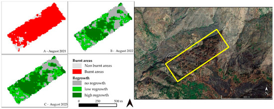
Figure 6.
Maps of regrowth dynamics at one and two years after the fire event (2021) using satellite date.
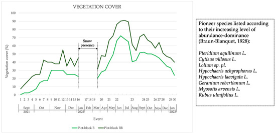
Figure 7.
Trends in vegetation cover of pioneer herbaceous and shrub species over time (on the x-axis, where each notch corresponds to measurements of vegetation taken every 15 days; groups of rainfall events are shown from 1 to 30) [74].
Later, in the last phase of the study, a characterisation of the vegetation cover of herbaceous/shrub species was carried out in order to determine the state of forest regeneration of the plots under investigation. On the whole, significant post-fire regeneration was detected in both plots B and BR, emphasising that fire action leads to natural regeneration processes and that at times, fire acts as an ecological factor regulating natural processes in forest ecosystems [69,70,71].
3.1.2. Auto-Regeneration of Pinus Radiata
Pinus radiata seems to regenerate better in the B plot block (with randomly felled logs) with 1.7 seedlings/m2, while only 0.4 seedlings/m2 were counted in the BR plot block, with very significant differences (F(3, 6) = 230, 3; p < 0.001); the higher density observed in B plot blocks (Scheme 2 and Scheme 3), however, could create greater competition among new seedlings resulting in the death of those that fail to establish themselves as they remain subdued. In the F plot block (used as “control”), no regeneration was observed (Figure 8a), indicating that the excessive density of the existing forest not affected by the fire prevented new plants from appearing. A greater height of the seedlings compared to the BR plot block (18 cm vs. 15 cm) was detected in B, even if the differences were not statistically significant (Figure 8b). Finally, a greater hypsometric differentiation of seedlings in the B plot block was recorded (Figure 9). These results seem to suggest that in the first two years, natural regeneration in the B plot block (randomly felled logs) is greater than in the BR (redirected felled logs).
Scheme 2.
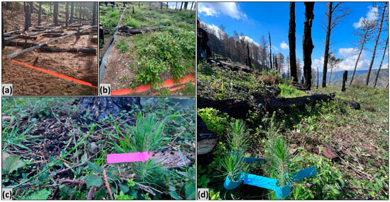
View of (a) BR sub-plot just set up and (b) pioneer vegetation established immediately upstream of the contour logs after a few months, (c) young pine seedlings and (d) vegetation cover spreading.
Scheme 3.
Auto-succession process of Pinus radiata (2 years old) within the BR plot block (redirected felled burnt logs) that emerges once the pioneer vegetation (that suppressed it) is now degraded.

Figure 8.
Median of and variation in seedling number (a) and seedling height (b) in the compared areas.

Figure 9.
Seedling distribution according to height class of Pinus radiata one year after the wildfire.
Overall, a significant post-fire regeneration was detected in the burnt plots (both in B and BR), highlighting that the action of fire triggers natural regeneration processes. Even if still preliminary, this evidence confirms the importance of fire as an ecological factor in the regulation of tree populations in forest ecosystems. A relationship between the presence of downed logs and the post-fire natural regeneration seems to reinforce what was already observed [89,90,91]. The lower regeneration capacity observed in the BR plot blocks is probably due to the rapid colonisation of herbaceous and shrubby vegetation occupying areas immediately stabilised after log placement that win the competition to gain space and light (Figure 9); this ecological dynamic negatively affected the post-fire tree regeneration by temporarily interfering with the natural recovery processes.
Pioneer species are characterised by an annual or biennial biological cycle, so they are destined to disappear over time. Although in the early stages the presence of ephemeral vegetation discourages natural tree regeneration, it plays an important protective function by covering the soil, especially when the first rains occur (as will be highlighted in Section 3.2). In addition, this pioneer vegetation, in its final phase, fertilises the soil by providing organic matter and creating better soil conditions that help to increase the resilience of the whole ecosystem, leaving young seedlings with more stable conditions for their establishment when the more ephemeral herbaceous and shrubby vegetation gradually disappears.
It is also confirmed that the post-fire vegetation dynamics do not promote an establishment of new forestry species, inducing a gradual return to the previous state. These dynamics, as in other studies [92,93,94,95], follow the “initial floristic composition” model, promoting the species already present before the fire with the self-succession of the Pinus radiata forest.
3.2. Effects on Runoff and Sediment Yield
Throughout 17 months of recording, the natural succession of the pioneer vegetation showed two clear patterns of plant development. As a result, changes in hydrological responses and post-fire erosion processes occurred. According to Table A1, the analysis of the means for the sediment records shows significant changes (p < 0.05) in each of the three plots compared individually with respect to the vegetation succession in the two periods analysed. In contrast, runoff did not show changes in any of the plots (Table A1).
Assessing the combined effect of sediment yield in relation to surface runoff, both periods of vegetation cover resulted in different erosion rates (Figure 10). The second period of vegetation cover provided lower sediment values in all plots, which may be due to inter-species competition leading to a higher density of plant root systems, combined with an increase in bryophytes and the occurrence of biological soil crusts, which produce a better soil consolidation in response to erosion [96,97]. Quantitatively, the B plot block showed the highest values of surface runoff and sediment yields, followed by the BR and F plot block. Observing the values recorded during the second vegetation cover period, it emerged that the BR plot block provided the lowest erosion rate in relation to surface runoff (Figure 10).
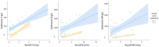
Figure 10.
Linear regression showing the scatter of recorded sediment yields and runoff values.
To explore the variation in the analysed plots, an ANCOVA was conducted in which the change in pioneer vegetation cover was related to sediment yield and surface runoff, using rainfall depth and intensity as covariates. Concerning sediment, significant changes (p = 0.015) were observed in the different plots in both periods of the vegetation cover analysed (Table A2), with ‘rainfall intensity’ as the most relevant covariate (p < 0.001). To determine in detail how vegetation affects each plots, a post hoc comparison was carried out (Table A3). In a within-plot analysis, a significant change was observed in sediment yields in plots B and BR (p < 0.001) due to the increase in pioneer vegetation, which was not the case in the control plot (p = 0.802) because the vegetation cover remained similar throughout the study period. A further finding was the effect of the gradient of rainfall depth and especially rainfall intensity, where rainfall over 70 mm (value 3) and rainfall intensity over 10 mm h−1 (values 2 and 3) led to changes in sediment yields across periods 1 and 2 of the pioneer vegetation cover (Figure 11).
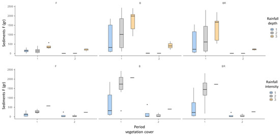
Figure 11.
Box plot diagram of the sediment yield values in the study plots. Vegetation cover periods were established from September 2021 to June 2022 (phase 1), and the second was established from June 2022 to January 2023 (phase 2). Rainfall depth: 1st category, values between 0 and 35 mm; 2nd category, values between 35 and 70 mm; 3rd category, values greater than 70 mm. Rainfall intensity: 1st category, values between 0 and 10 mm h−1; 2nd category, values between 10 and 30 mm h−1; 3rd category, values greater than 30 mm h−1.
During the initial period of the vegetation cover (phase 1), significant changes were found between plots B and BR compared to the control plot F (p < 0.001), although this scenario changed as the vegetation cover growth progressed (phase 2); no significant differences in sediment yield were observed in the plot block F compared to plots B and BR (p = 0.999 and p = 1.000, respectively). These findings indicate that spontaneous vegetation growth provided greater protection to the soil and hence from the impact of erosion effects. The comparison between plots B and BR showed no significant changes over the study period (Table A3), although lower sediment values were observed due to both the effect of rainfall intensity and higher rainfall amounts (Figure 11).
Regarding surface runoff, there were no significant changes in sediment yield (p < 0.996) for all the plots in both periods of the vegetation cover analysed (Table A4). The post hoc comparison (Table A5) showed no significant changes in the within-plot analysis (p-values of 0.874 for F plot block, 0.896 for B and 0.845 for BR), where the pioneer vegetation growth did not significantly alter surface runoff; just higher values of rainfall intensity (value 3) induced within-plot changes (Figure 12). An inter-plot analysis of surface runoff, in which rainfall and rainfall intensity both played a significant role as covariates (p < 0.001) in the ANCOVA model, showed significant changes (Table A4). The surface runoff recorded in plots B and BR compared to plots F remained different in the two vegetation cover periods analysed (Table A5), particularly at the highest values of rainfall and intensity (Figure 12). Lastly, the comparison of runoff between plots B and BR showed no significant changes over the study period (Table A4).
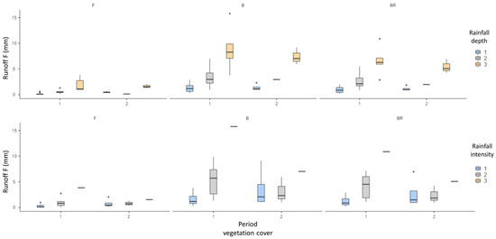
Figure 12.
Box plot diagram of the runoff values in the study plots. Vegetation cover periods were established from September 2021 to June 2022 (phase 1), and the second was established from June 2022 to January 2023 (phase 2). Rainfall depth: 1st category, values between 0 and 35 mm; 2nd category, values between 35 and 70 mm; 3rd category, values greater than 70 mm. Rainfall intensity: 1st category, values between 0 and 10 mm h−1; 2nd category, values between 10 and 30 mm h−1; 3rd category, values greater than 30 mm h−1.
These results suggest that the natural regeneration of the forest in our research is still at an early stage, which is insufficient to allow infiltration dynamics comparable to the pre-fire period. According to several research findings, the infiltration excess runoff threshold increases over long periods of time [98,99,100]; therefore, it requires years after a forest fire to minimise surface runoff. Such hydrologic effects emphasise the relevance of actions to rehabilitate hillside properties to minimise the risks of flash floods and debris flows arising from the generation of excessive runoff [99,100], as well as water pollution processes [101].
Overall, the results confirm the previous investigations [49], including by extending the number of event groups from 24 to 30 (January 2023) (Figure A1); of these, events 7 and 23 remain those with the highest values of maximum rainfall intensity (30.6 mm h−1 and 35.4 mm h−1) and cumulative rainfall depth (294.4 mm and 105.4 mm, respectively).
The analysis of runoff and sediment yield data confirms the strong correlations between runoff and cumulative rainfall depths, as well as between sediment production and rainfall intensity; the trend of individual plot blocks is also confirmed (Figure A1).
The direct relationship between runoff and precipitation is also confirmed, highlighting how the combined effect of redirected burnt logs (due to the partial “breaking effect” of the slope length in the BR plot block) and pioneer vegetation cover (which, taking advantage of the higher insolation conditions, very quickly colonised the stabilised areas behind the barriers (Figure A2)) have a positive influence in terms of runoff and soil erosion mitigation because of reducing the sediment detachment/transport capacity [78,81,84,85,86,87].
The effect of vegetation is appreciable in event group 27, showing a cumulative rainfall height of 169.2 mm (the other events vary between 20 and 60 mm) and a rainfall intensity of 9.4 mm h−1; although these values are among the highest in the whole monitored period, the hydrologic response is quite moderate (Figure A1).
Runoff volume and sediment yield are always lower in the BR plots than in the B plots. The average reduction (n = 30) was about 25% (standard deviation of 13%, encompassing events with differences ranging from 5% in event 1 to values above 200% in events 6, 20, 21 and 22) and 24% (±75%).
As already reported by Bombino et al. [49], the first three events are where the smallest differences are found. This is because immediately after the wildfire, the first rains find the soil denuded of vegetation and covered with a layer of ash, which drastically reduces infiltration capacity [76]. This is confirmed by the hydrological behaviour of the BR and B plots during the first three events showing high values of runoff and sediment yield even though the rainfall characteristics (rainfall depth and intensity) are not so critical. A significant reduction in runoff and sediment yields in the BR plots is seen from the fourth rainfall event onward.
Monitoring the degree of ground cover by pioneer species showed consistently higher values (34% on average; n = 60) in the BR plots [102]. The combined effect of redirected logs and vegetation becomes more evident from the 13th event, where, even with the most intense rainfall events, a drastic decrease in runoff volume and sediment production is observed (see, for example, events 17, 19, 23, 24 and 27, Figure A2).
3.3. Durability and Mechanical Properties of In Situ Logs
The average wood density determined in the laboratory was 450 kg/m3. From the first tests conducted in the field with non-destructive techniques, it emerged that with the resistograms, it is possible to observe how the internal wood (not damaged by fire) has a high capacity of drilling resistance (DR) because the wood tissues are perfectly intact (Figure A3a). The resistograms of the fire-damaged logs in the bark portion (Figure A3b) and below it (Figure A3c), instead, show (already from the first survey) low DRs that describe a semi-intact portion of wood texture in the first external centimetres, and the extent of which depends on the severity of the fire suffered by the log.
What has been obtained is demonstrated by the first log tests carried out with the Microsecond Timer (December 2021), which show high acoustic wave velocities and, therefore, an almost intact woody structure (Table A6).
From the first surveys, it can be observed that the damage suffered by the burnt logs was concentrated only in the external part, i.e., the one exposed to the flames, while the internal part had healthy or semi-intact tissues. However, as expected, the action of the biotic and abiotic components of the environment, over the monitored time (17 months), caused a slow degradation process of the wood (Figure A4). The data collected in subsequent monitoring have, in fact, shown a slight and constant reduction in the density and speed of propagation of sound waves in the logs (Table A6, Figure 13). The propagation speed of acoustic waves into the wood tissues of the logs monitored showed a decrease of between 10 and 30% in the speeds recorded in the first survey. This suggests that the wood of the logs used in this study, despite the natural degradation process of the tissues, is able to maintain functional capacities for a sufficiently long period to allow the anti-erosive barrier action of the soil to take place until the start of initial forest recovery after the fire has passed.
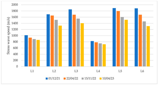
Figure 13.
The propagation speed of acoustic waves into the wood tissues of the logs monitored.
The slow but gradual decay of the woody structure, observed over 17 months (averaging less than 20 percent compared to the first measurement), appears not to affect the functionality of the logs. The available data suggest that it takes more than 10 years to reach log decay such that its function is not impaired (indicated by values of stress wave velocity lower than 400 m/s); however, in the meantime, the ecological dynamics of the forest will have allowed tree regeneration to establish itself and develop effectively.
In summary, the diagram shown in Figure 14 illustrates how the proposed nature-based solution exerts its effectiveness in the short and long terms. Immediately after the logs are manually re-oriented along the contour lines, there is, as demonstrated, a significant reduction in runoff and sediment productions and, thus, slope stabilisation. As early as the first few weeks after placement of the burnt logs, pioneer vegetation (herbaceous and shrubby species) becomes established in the areas behind the logs and covers large areas in a short time. At this stage, the combined effect of the re-directed logs and the spontaneous vegetation ensures the best protection of the soil from erosion especially with the arrival of the first heavy autumn rains. The significant presence of pioneer vegetation, however, takes away space and light from the natural seedlings of Pinus radiata, which, as has been observed, is more scarce in the arranged plots. However, the herbaceous vegetation is likely to gradually disappear (orange line) because of both seasonal and vital/biological cycles. Meanwhile, the young forest will begin to have more light and space and be able to take advantage, in addition, of the previous slope stability conditions created by the measure. Over time, as the logs gradually degrade (over an estimated 10 years; brown line), natural regeneration will have become established and developed to the point of self-healing of the forest dynamics, restoring the ecological functionality of the ecosystem as well as the best condition of soil protection it can provide (green line).
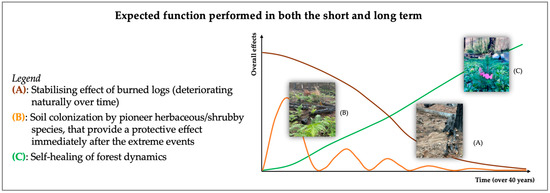
Figure 14.
Observed and expected effects of the proposed nature-based solution in both short and long terms.
4. The Legal Regulatory Framework on Wildfires
In Italy, Art. 10 of the “Law on Forest Fires” No. 353 of 21 November 2000, establishes, among other aspects, that in wooded areas, whose topsoils have been affected by fire, “reforestation and environmental engineering activities supported with public financial resources are prohibited for five years, unless specifically authorised by the general directorate competent in matter of the Ministry of the Environment, for state protected natural areas, or by the competent region, in other cases, for documented situations of hydrogeological instability and in situations in which an intervention is urgently needed for the protection of particular environmental and landscape values” [103].
As widely documented in the literature and confirmed by Bombino et al. [58] as within the present study, the phenomena of hydrogeological instability, which involve the processes of surface runoff, soil erosion and sediment transport, as well as landslides and mass movements, are widespread in Italy and are accentuated or triggered by rainfall, especially of medium–high intensity. These phenomena also concern “state protected natural areas” and areas with “particular environmental and landscape values”. Forest fires, by eliminating the protective action of the topsoils exerted by vegetation, tend to aggravate this scenario, both in situations of already active instability and in potentially degenerative situations. This aggravation can already occur immediately due to the first rains that follow the hot season when most forest fires occur in the Mediterranean area. The exacerbation of hydrogeological instability phenomena resulting from forest fires occurs; therefore, significant and urgent repair interventions are required [55].
The urgency of the interventions is often disregarded by the considerable duration of the ordinary technical–administrative activities for the detection and processing of the documentation, as well as by the preparatory evaluation activities for the release of specific authorisations by the competent authorities, both at the ministerial and regional levels, as foreseen by Law No. 353/2000, even in the case of the “procedures in the event of extreme urgency and civil protection” referred to in article 163 of the legislative decree of 18 April 2016 No. 50, bearing the code of public contracts.
From this perspective, it appears of interest to explore the feasibility of effective intervention measures [104] that can actually be carried out promptly, in compliance with the purposes and constraints of Law No. 353/2000. In this regard, the measure represented by the simple manual reorientation in situ, along contour lines or in a direction perpendicular to the direction of maximum slope of the terrain, of the logs felled by the fire does not seem to be included among the activities classifiable as “environmental engineering” (Council of State, Section 5, 25/02/2020, no. 1391), subject to authorisation and, therefore, to the duration of the preliminary investigation procedure. In fact, the implementation of such an intervention, which aims at enhancing the self-regeneration capacity of the forest [105] without introducing particular “invasive” actions of “disturbance”, does not involve, without prejudice to the commitment of manpower supported by public financial resources, which are, moreover, limited. The actions and categories of works falling under so-called “environmental engineering”, even when configured as “naturalistic engineering” (involving the construction of a work-site and access roads, excavations and earthworks, the use of particular construction materials, the construction of structural works and the use of machines and technologies), are discussed in the regional price lists, which is a reference tool for the preventive quantification, planning and construction of public works pursuant to Art. 23 of Legislative Decree No. 50/2016.
Should the nature-based intervention be recognised as useful and effective with respect to the control of hydrogeological instability and the protection of particular environmental and landscape values, it might, therefore, not fall within the cases of prohibition provided for by Law No. 353/2000. The implementation of the naturalistic measure could be subject to communication (self-certification) to the competent authorities, with a view to administrative simplification [106] and streamlining of the bureaucratic burden, as well as to indirectly favor the registration of the wooded areas affected by fire that, and although required by law, this often appears, indeed, to be disregarded or only partially accomplished.
On a comparative profile, in Spain, Law No. 43/2003 of November 21 (the so-called “Ley de Montes”)—the revision of which has been in force since 22 September 2022—in article 50 entitled “Maintenance and restoration of the forest character of burnt land” provides that:
«1. The Autonomous Communities must ensure the conditions for the restoration of burnt forest land and it is prohibited: (a) The change in intended use of forests for at least 30 years; (b) Any activity incompatible with the regeneration of the vegetation cover, during the period determined by the regional legislation. Exceptionally, the autonomous communities can agree exceptions to these bans provided that, before the forest fire, the change in use was foreseen: (a) A previously approved planning tool; (b) A planning instrument awaiting approval, if it has already been the subject of a favorable environmental assessment or, if this is not required, if it has already been subjected to the public information process; (c) An agroforestry policy guideline that contemplates the extensive agricultural or zootechnical use of non-forested forests in a state of abandonment.»
Therefore it can be considered that the Spanish legislation is very detailed, encouraging forestry research, with care to management profiles, also from a commercial point of view as well as protection and sustainable development. Competencies are divided between the state level and local communities, which enjoy a certain degree of autonomy, also in terms of authorisation.
In Greece, the 1975 Constitution Laws No. 86/1969, No. 998/1979 and No. 1650/1986 constitute the basic legal framework of the country for the protection and management of forest and other wooded land. The forest and other wooded land are protected by Articles 24 and 117 of the Constitution. Law No. 86/1969 codifies almost all the laws that had been issued since 1928 and has been amended and completed by Law No. 4173/1929. This law constitutes the Forest Code of the country. Furthermore, in Greece, in the last decades, the fire problem has been growing mainly due to climate changes, socio-economic changes in land use and demographic characteristics of the country: the reduction in the rural population has led to the continuity of horizontal and vertical vegetation, as well as the accumulation of forest biomass, increasing the probability of fixed fires and making them more difficult to control. Serious institutional failures further exacerbate the problem. In addition to the social, environmental and economic impacts of wildfires on the landscape, including loss of public and private assets and destruction of critical infrastructure, they pose a significant threat to human health and safety. Efforts are currently underway to improve the fire management system, including enhancing the level of cooperation between the agencies involved.
In Turkish legislation, the definitions regarding forest fires are not clear. Some necessary definitions can be found in statutes and regulations. Rehabilitation is one of the strengths of the current legislation. Reforestation of burnt forestlands is guaranteed under the Turkish Constitution, and the Forest Law includes provisions that support the issue [107].
5. Final Remarks and Research Perspectives
The preliminary results of the plot–scale experimental investigation, with a multidisciplinary approach, carried out immediately after the extreme wildfires in the Aspromonte Massif (southern Calabria, Italy) in 2021 seem to support the effectiveness of the in situ contour reorientation of felled logs to enhance forest resilience and reduce erosion. Logs damaged by fire have clearly demonstrated that they can provide physical protection after fire if reoriented as this study shows. Of course, it is important to continue to study how long this protection may endure. This nature-based solution, simply manually realised, shows positive short- and long-term effects on slope stabilisation and rapid protection of the bare soil by pioneer species, as well as on forest self-regeneration.
In this study, the post-fire scenarios (bare soil with felled burnt logs randomly displaced and contour redirected) were compared with the pre-fire Pinus radiata asset.
The combined effect of the redirected burnt logs (as erosion barriers) and the spontaneous herbaceous/shrubby vegetation (establishing behind the structures just after three weeks from the treatment) significantly reduce runoff and sediment yields (both by about 30%) under natural rainfall (about 1500 mm in 17 months). A positive correlation was found between the pioneer vegetation cover and a reduction in both runoff and sediment yields in the treated plot blocks.
Compared to the post-fire scenario (randomly downed logs), the regeneration of Pinus radiata is lower (about four times less) in the arranged plots, because a few days after the treatment, the ephemeral vegetation quickly tends to occupy all the useful space, especially behind the logs (due to the slope stabilisation effect). After two years, however, new Pinus radiata seedlings manage to establish themselves thanks to the progressive degradation of herbaceous vegetation having an annual and a biennial biological cycle. This vegetation, once degraded, enriches the soil with organic substance, creating better edaphic and soil moisture conditions for the growing seedlings.
Despite the fact that the intensity and severity of the wildfire caused the trees to fall to the ground, the logs in situ used to carry out the nature-based solution are still good in terms of durability, so they can maintain a high structural and functional capacity over a longer period of time (presumably up to 10–15 years), i.e., for as long as it takes for the forest to re-establish its evolutionary and growth dynamics.
This aspect is extremely important as it exploits the effect of the measure in both the short and long terms, highlighting how burnt logs may be suitable for use in bioengineering techniques.
The in situ contour manually redirected felled logs is a nature-based solution that is economically sustainable. Moreover, it seems to comply with the limitation imposed by Italian Law on forests affected by wildfire. It seems to be well suited for timely intervention in hydrogeologically vulnerable contexts and for promoting forestry self-regeneration processes.
Author Contributions
The paragraph relating to the study area and the wildfire characterisation was edited by D.D., L.M.M. and S.P.; paragraphs relating to forest regeneration aspects were edited by P.A.M.; paragraphs relating to the wood technology and worksite aspects were edited by A.R.P.; paragraphs relating to the hydrological aspects were curated by G.B., D.D., L.M.M., P.P.C. and S.M.Z.; the paragraph relating the regulatory aspects and compliance with the Italian regulations was edited by G.L.; conceptualisation, G.B.; methodology, G.B., D.D. and S.M.Z.; field surveys and data collection, All Authors; validation, All Authors; data curation and formal analysis, All Authors; writing—original draft preparation, G.B., D.D. and L.M.M.; writing—review and editing, G.B., D.D. and S.M.Z.; supervision, G.B., D.D. and S.M.Z.; project funding, G.B. and S.M.Z. All authors have read and agreed to the published version of the manuscript.
Funding
This work was funded by (i) the Next Generation EU—Italian NRRP, Mission 4, Component 2, Investment 1.5, specifically the call for the creation and strengthening of ‘Innovation Ecosystems’ and the building of ‘Territorial R&D Leaders’ (Directorial Decree n. 2021/3277). The project Tech4You—technologies for climate change adaptation and quality of life improvement, was assigned the identification no. ECS0000009. This work reflects only the authors’ views and opinions and does not necessarily reflect those of the Ministry for University and Research or the European Commission, who can be considered responsible for them.
Data Availability Statement
Data are contained within the article.
Acknowledgments
The authors are grateful to the Francesco Saccà agro-forestry farm in Roccaforte del Greco for providing access to the experimental system and logistic support.
Conflicts of Interest
The authors declare no conflicts of interest.
Appendix A
Table A1.
Sediment yield and runoff analysis on vegetation cover effect using a one-way ANOVA.
Table A1.
Sediment yield and runoff analysis on vegetation cover effect using a one-way ANOVA.
| F | df1 | df2 | p | |
|---|---|---|---|---|
| Sediment F | 60.016 | 1 | 17.2 | 0.025 |
| Sediment B | 218.024 | 1 | 27.3 | <0.001 |
| Sediment BR | 208.164 | 1 | 23.3 | <0.001 |
| Runoff C | 0.4086 | 1 | 17.6 | 0.531 |
| Runoff B | 0.0283 | 1 | 15.2 | 0.869 |
| Runoff BR | 0.0259 | 1 | 15.0 | 0.874 |
Table A2.
Sediment yield analysis on vegetation cover effect using ANCOVA. Using sediment yield as the dependent variable applied on fixed factors in plots and vegetation cover periods, where rainfall depth and rainfall intensity were covariates.
Table A2.
Sediment yield analysis on vegetation cover effect using ANCOVA. Using sediment yield as the dependent variable applied on fixed factors in plots and vegetation cover periods, where rainfall depth and rainfall intensity were covariates.
| Sum of Squares | df | Mean Square | F | p | |
|---|---|---|---|---|---|
| Plot | 2.93 × 10⁶ | 2 | 1.47 × 10⁶ | 6.11 | 0.003 |
| VegCover | 9.27 × 10⁶ | 1 | 9.27 × 10⁶ | 38.62 | <0.001 |
| Intensity | 3.32 × 10⁶ | 1 | 3.32 × 10⁶ | 13.85 | <0.001 |
| Rain | 630,274 | 1 | 630,274 | 2.63 | 0.109 |
| Plot ∗ VegCover | 2.13 × 10⁶ | 2 | 1.07 × 10⁶ | 4.45 | 0.015 |
| Residuals | 1.97 × 10⁷ | 82 | 240,038 |
Note: ∗ indicates the combined analysis of the two parameters.
Table A3.
ANCOVA post hoc comparison of sediment yield using as fixed factors the plots and vegetation cover periods applying Tukey correction method.
Table A3.
ANCOVA post hoc comparison of sediment yield using as fixed factors the plots and vegetation cover periods applying Tukey correction method.
| Comparison | |||||||||
|---|---|---|---|---|---|---|---|---|---|
| Plot | Cover Veg. | Plot | Cover Veg. | Mean Difference | SE | df | t | ptukey | |
| F | 1 | - | F | 2 | 258.02 | 204 | 82.0 | 12.668 | 0.802 |
| B | 1 | - | B | 2 | 1067.12 | 204 | 82.0 | 52.394 | <0.001 |
| BR | 1 | - | BR | 2 | 896.82 | 204 | 82.0 | 44.032 | <0.001 |
| F | 1 | - | B | 1 | −895.83 | 148 | 82.0 | −60.643 | <0.001 |
| F | 2 | - | B | 2 | −86.73 | 245 | 82.0 | −0.3541 | 0.999 |
| F | 1 | - | BR | 1 | −645.80 | 148 | 82.0 | −43.717 | <0.001 |
| F | 2 | - | BR | 2 | −7.00 | 245 | 82.0 | −0.0286 | 1.000 |
| B | 1 | - | BR | 1 | 250.03 | 148 | 82.0 | 16.926 | 0.541 |
| B | 2 | - | BR | 2 | 79.73 | 245 | 82.0 | 0.3255 | 0.999 |
Note. Comparisons are based on estimated marginal means.
Table A4.
Runoff analysis on vegetation cover effect using ANCOVA. Using sediment yield as the dependent variable applied on fixed factors in plots and vegetation cover periods, where rainfall depth and rainfall intensity were covariates.
Table A4.
Runoff analysis on vegetation cover effect using ANCOVA. Using sediment yield as the dependent variable applied on fixed factors in plots and vegetation cover periods, where rainfall depth and rainfall intensity were covariates.
| Sum of Squares | df | Mean Square | F | p | |
|---|---|---|---|---|---|
| Plot | 106.129 | 2 | 53.065 | 27.541 | <0.001 |
| VegCover | 7.030 | 1 | 7.030 | 3.649 | 0.060 |
| Rain | 180.865 | 1 | 180.865 | 93.872 | <0.001 |
| Intensity | 30.536 | 1 | 30.536 | 15.849 | <0.001 |
| Plot ∗ VegCover | 0.015 | 2 | 0.007 | 0.004 | 0.996 |
| Residuals | 157.991 | 82 | 1.927 |
Note: ∗ indicates the combined analysis of the two parameters.
Table A5.
ANCOVA post hoc comparison of runoff using as fixed factors the plots and vegetation cover periods applying Tukey correction method.
Table A5.
ANCOVA post hoc comparison of runoff using as fixed factors the plots and vegetation cover periods applying Tukey correction method.
| Comparison | |||||||||
|---|---|---|---|---|---|---|---|---|---|
| Plot | Cover Veg. | Plot | Cover Veg. | Mean Difference | SE | df | t | ptukey | |
| F | 1 | - | F | 2 | 0.643 | 0.577 | 82.0 | 1.114 | 0.874 |
| B | 1 | - | B | 2 | 0.610 | 0.577 | 82.0 | 1.058 | 0.896 |
| BR | 1 | - | BR | 2 | 0.682 | 0.577 | 82.0 | 1.181 | 0.845 |
| F | 1 | - | B | 1 | −2.925 | 0.419 | 82.0 | −6.989 | <0.001 |
| F | 2 | - | B | 2 | −2.957 | 0.694 | 82.0 | −4.261 | <0.001 |
| F | 1 | - | BR | 1 | −2.034 | 0.419 | 82.0 | −4.859 | <0.001 |
| F | 2 | - | BR | 2 | −1.995 | 0.694 | 82.0 | −2.875 | 0.056 |
| B | 1 | - | BR | 1 | 0.891 | 0.419 | 82.0 | 2.130 | 0.283 |
| B | 2 | - | BR | 2 | 0.963 | 0.694 | 82.0 | 1.387 | 0.735 |
Note. Comparisons are based on estimated marginal means.
Table A6.
Stress wave velocities recorded during the surveys on Pinus Radiata species.
Table A6.
Stress wave velocities recorded during the surveys on Pinus Radiata species.
| ID Log | Survey | Distance between Sensors (cm) | Stress Wave Velocity (m/s) (Standard Deviation) |
|---|---|---|---|
| L1 | 1 December 2021 | 29 | 1014 (1.23) |
| L2 | 22 | 1692 (1.25) | |
| L3 | 25 | 1851 (0.96) | |
| L4 | 22 | 824 (2.36) | |
| L5 | 35 | 1891 (2.89) | |
| L6 | 49 | 1884 (0.98) | |
| L1 | 22 April 2022 | 29 | 933 (1.56) |
| L2 | 22 | 1651 (2.66) | |
| L3 | 25 | 1677 (1.33) | |
| L4 | 22 | 785 (1.98) | |
| L5 | 35 | 1794 (1.11) | |
| L6 | 49 | 1678 (2.93) | |
| L1 | 15 November 2022 | 29 | 890 (2.14) |
| L2 | 22 | 1509 (1.47) | |
| L3 | 25 | 1552 (1.18) | |
| L4 | 22 | 748 (1.61) | |
| L5 | 35 | 1602 (2.16) | |
| L6 | 49 | 1459 (2.92) | |
| L1 | 10 April 2023 | 29 | 861 (1.58) |
| L2 | 22 | 1324 (1.62) | |
| L3 | 25 | 1403 (1.39) | |
| L4 | 22 | 719 (1.16) | |
| L5 | 35 | 1513 (2.54) | |
| L6 | 49 | 1308 (1.63) |
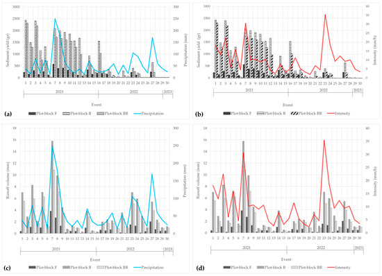
Figure A1.
Evolution of sub-plot mean values (n = 3) of runoff volumes (a,b) and sediment yields (c,d) related to rainfall depth and maximum intensity.
Figure A1.
Evolution of sub-plot mean values (n = 3) of runoff volumes (a,b) and sediment yields (c,d) related to rainfall depth and maximum intensity.
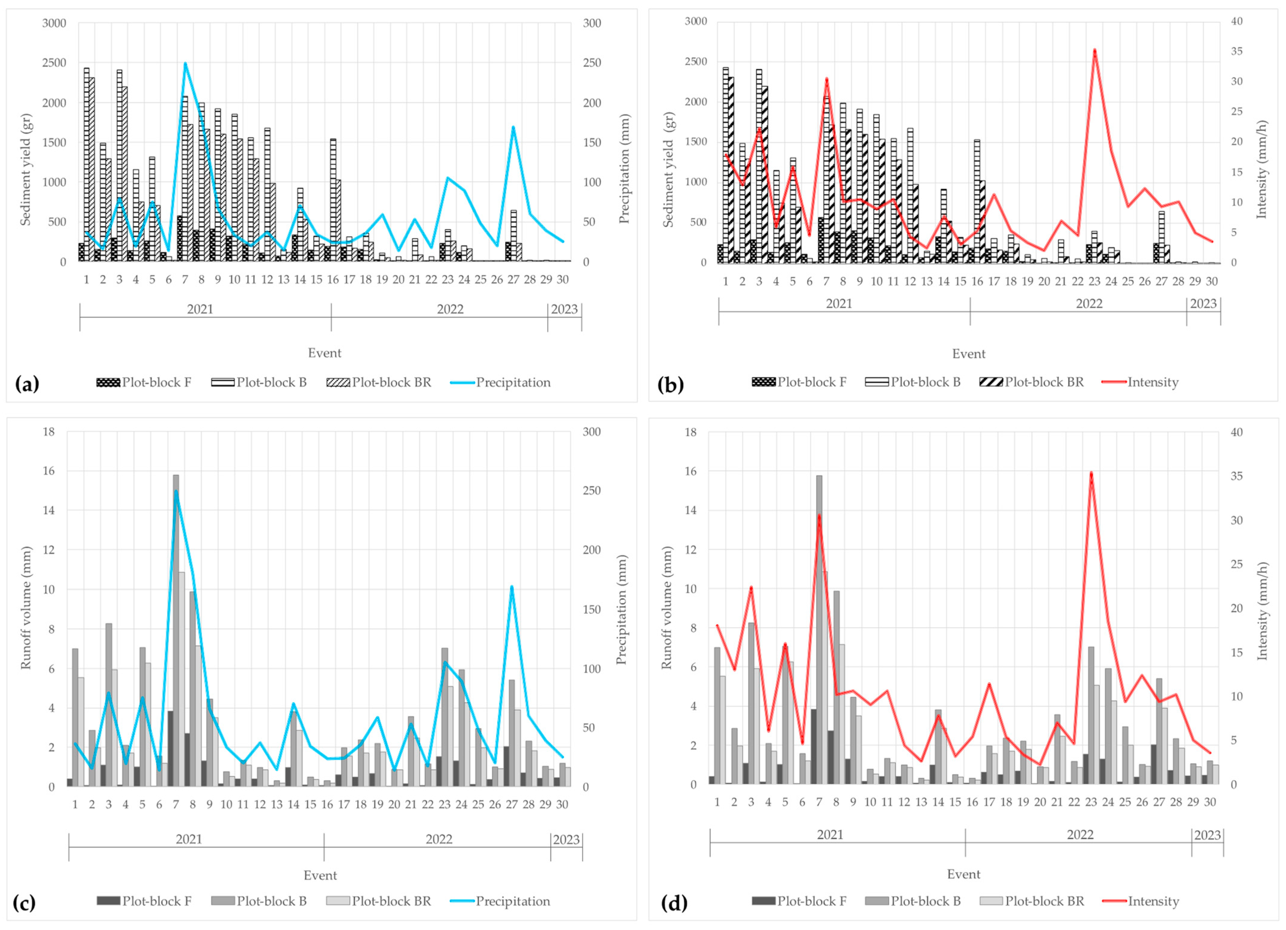
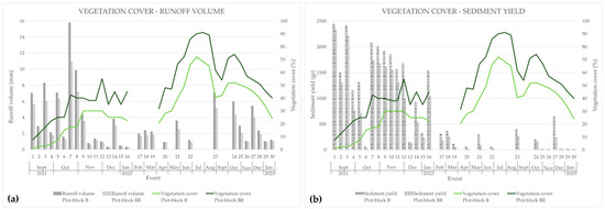
Figure A2.
Evolution of vegetation cover in relation to runoff volume (a) and sediment yield (b).
Figure A2.
Evolution of vegetation cover in relation to runoff volume (a) and sediment yield (b).
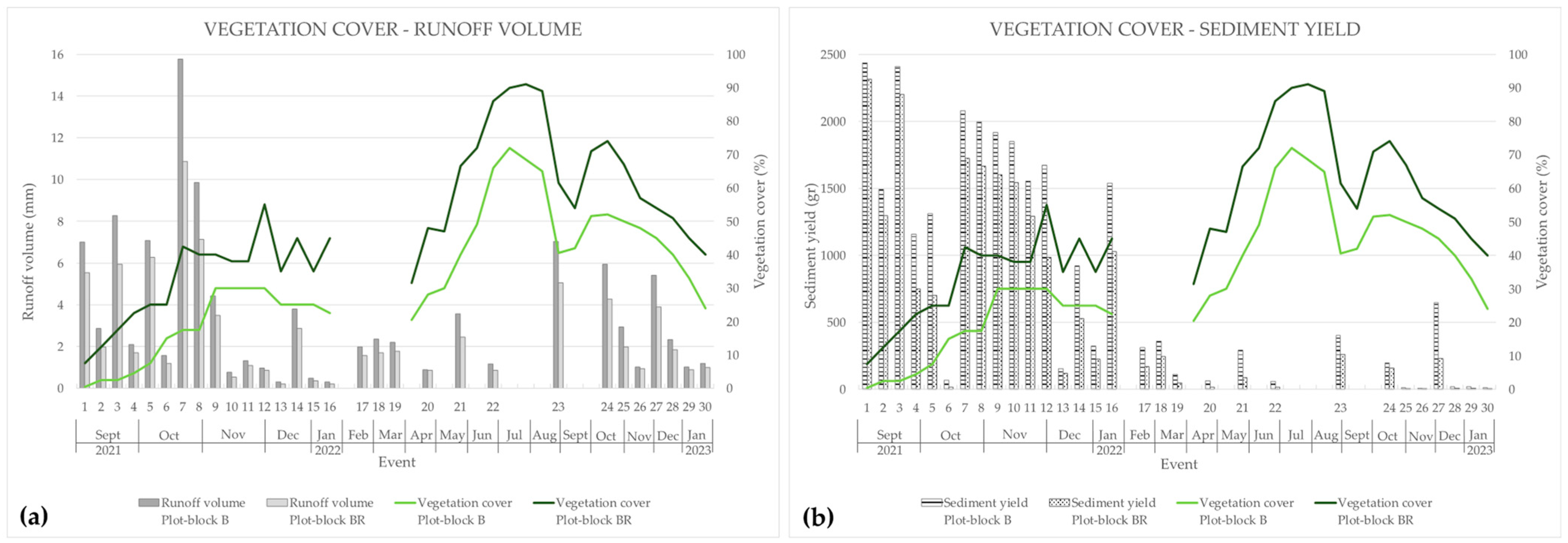
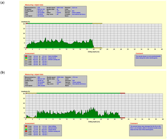
Figure A3.
Resistograms referring to December 2021 of a log not damaged by fire and whose wood is in good condition (a), a log damaged by fire in the bark portion (the fire harmed the first two external centimetres of wood) (b), and a log damaged by fire also in the portion below the bark (the fire harmed the woody tissue over five centimetres deep (c)).
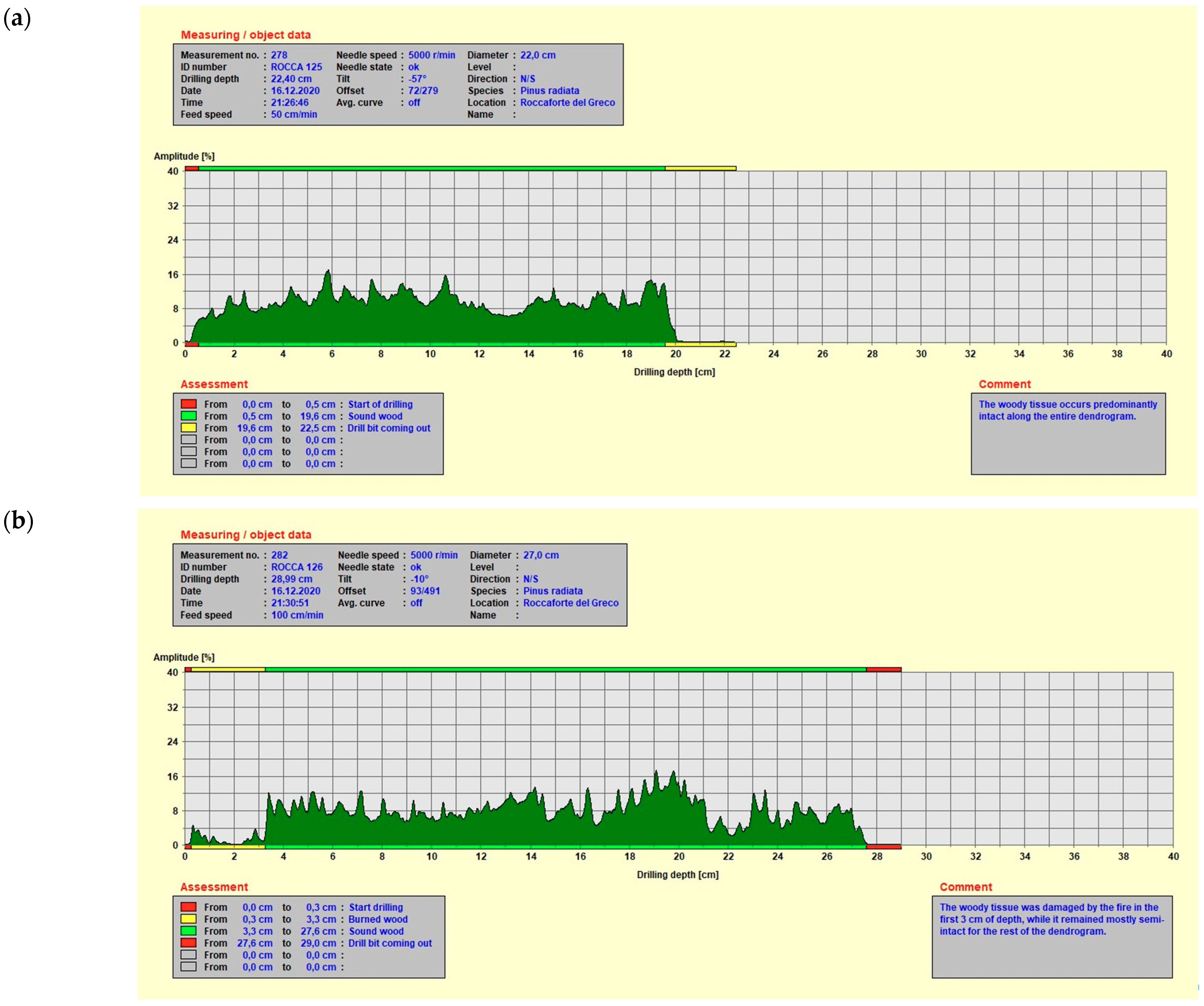
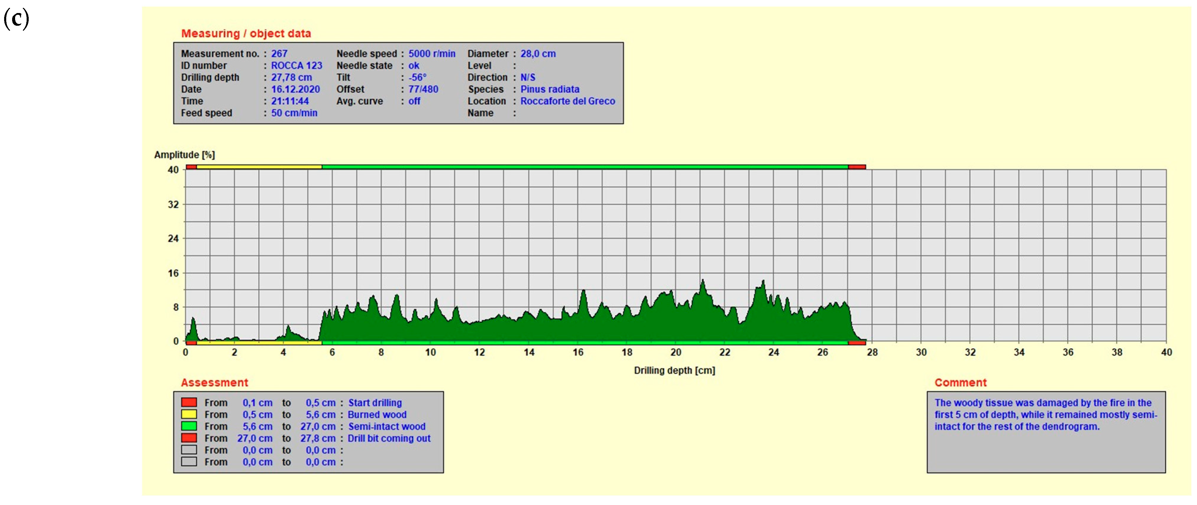


Figure A4.
Resistograms referring to October 2022 of the log (the same as the previous surveys) not damaged by fire and whose wood is in good condition (a), a log damaged by fire in the bark portion (the fire harmed the first two external centimetres of wood) (b), and a log damaged by fire also in the portion below the bark (the fire harmed the woody tissue over five centimetres deep (c)).
References
- Carrión, J.S.; Sánchez-Gómez, P.; Mota, J.F.; Yll, R.; Chaín, C. Holocene Vegetation Dynamics, Fire and Grazing in the Sierra de Gádor, Southern Spain. Holocene 2003, 13, 839–849. [Google Scholar] [CrossRef]
- Fernandes, P.M.; Monteiro-Henriques, T.; Guiomar, N.; Loureiro, C.; Barros, A.M.G. Bottom-Up Variables Govern Large-Fire Size in Portugal. Ecosystems 2016, 19, 1362–1375. [Google Scholar] [CrossRef]
- Rodrigues, M.; Cunill Camprubí, À.; Balaguer-Romano, R.; Coco Megía, C.J.; Castañares, F.; Ruffault, J.; Fernandes, P.M.; Resco de Dios, V. Drivers and Implications of the Extreme 2022 Wildfire Season in Southwest Europe. Sci. Total Environ. 2023, 859, 160320. [Google Scholar] [CrossRef] [PubMed]
- dos Santos, S.M.B.; Bento-Gonçalves, A.; Franca-Rocha, W.; Baptista, G. Assessment of Burned Forest Area Severity and Postfire Regrowth in Chapada Diamantina National Park (Bahia, Brazil) Using dNBR and RdNBR Spectral Indices. Geosciences 2020, 10, 106. [Google Scholar] [CrossRef]
- Hosseini, M.; Keizer, J.J.; Pelayo, O.G.; Prats, S.A.; Ritsema, C.; Geissen, V. Effect of Fire Frequency on Runoff, Soil Erosion, and Loss of Organic Matter at the Micro-Plot Scale in North-Central Portugal. Geoderma 2016, 269, 126–137. [Google Scholar] [CrossRef]
- Fernandez-Anez, N.; Krasovskiy, A.; Müller, M.; Vacik, H.; Baetens, J.; Hukić, E.; Kapovic Solomun, M.; Atanassova, I.; Glushkova, M.; Bogunović, I.; et al. Current Wildland Fire Patterns and Challenges in Europe: A Synthesis of National Perspectives. Air Soil Water Res. 2021, 14, e117862212110281. [Google Scholar] [CrossRef]
- Ascoli, D.; Marchetti, M. Territorio, bioeconomia e gestione degli incendi: Una sfida da raccogliere al più presto|SISEF.ORG. For. J. Silvic. For. Ecol. 2018, 15, 71. [Google Scholar]
- San-Miguel-Ayanz, J.; Durrant, T.; Boca, R.; Maianti, P.; Libertá, G.; Artés-Vivancos, T.; Oom, D.; Branco, A.; de Rigo, D.; Ferrari, D.; et al. Forest Fires in Europe, Middle East and North Africa 2021; Publications Office of the European Union: Luxembourg, 2022. [Google Scholar]
- Shakesby, R. Post-Wildfire Soil Erosion in the Mediterranean: Review and Future Research Directions. Earth-Sci. Rev. 2011, 105, 71–100. [Google Scholar] [CrossRef]
- Whelan, R.J. The Ecology of Fire; Cambridge University Press: Cambridge, UK, 1995. [Google Scholar]
- Morgan, P.; Hardy, C.C.; Swetnam, T.W.; Rollins, M.G.; Long, D.G. Mapping Fire Regimes across Time and Space: Understanding Coarse and Fine-Scale Fire Patterns. Int. J. Wildland Fire 2001, 10, 329–342. [Google Scholar] [CrossRef]
- DeBano, L.F.; Neary, D.G.; Ffolliott, P.F. Fire Effects on Ecosystems; John Wiley & Sons: Hoboken, NJ, USA, 1998. [Google Scholar]
- Neary, D.G.; Klopatek, C.C.; DeBano, L.F.; Ffolliott, P.F. Fire Effects on Belowground Sustainability: A Review and Synthesis. For. Ecol. Manag. 1999, 122, 51–71. [Google Scholar] [CrossRef]
- Key, C.H.; Benson, N.C. Post-Fire Burn Assessment by Remote Sensing on National Park Service Lands, and Measuring and Remote Sensing of Burn Severity; US Geological Survey Wildland Fire Workshop: Los Alamos, NM, USA, 2002; pp. 2–11. [Google Scholar]
- Smith, A.M.S.; Hudak, A.T.; Smith, A.M.S.; Hudak, A.T. Estimating Combustion of Large Downed Woody Debris from Residual White Ash. Int. J. Wildland Fire 2005, 14, 245–248. [Google Scholar] [CrossRef]
- Montenegro, G.; Ginocchio, R.; Segura, A.; Keely, J.E.; Gomez, M. Fire Regimes and Vegetation Responses in Two Mediterranean-Climate Regions. Rev. Chil. Hist. Nat. 2004, 77, 455–464. [Google Scholar] [CrossRef]
- Pérez-Cabello, F.; Echeverría, M.T.; Ibarra, P.; De La Riva, J. Effects of Fire on Vegetation, Soil and Hydrogeomorphological Behavior in Mediterranean Ecosystems. In Earth Observation of Wildland Fires in Mediterranean Ecosystems; Chuvieco, E., Ed.; Springer: Berlin/Heidelberg, Germany, 2009; pp. 111–128. ISBN 978-3-642-01753-7. [Google Scholar]
- Santana, V.M.; Alday, J.G.; Baeza, M.J. Effects of Fire Regime Shift in Mediterranean Basin Ecosystems: Changes in Soil Seed Bank Composition among Functional Types. Plant Ecol. 2014, 215, 555–566. [Google Scholar] [CrossRef]
- Barbati, A.; Arianoutsou, M.; Corona, P.; De Las Heras, J.; Fernandes, P.; Moreira, F.; Papageorgiou, K.; Vallejo, R.; Xanthopoulos, G. Post-Fire Forest Management in Southern Europe: A COST Action for Gathering and Disseminating Scientific Knowledge. IForest-Biogeosciences For. 2010, 3, 5. [Google Scholar] [CrossRef]
- Francos, M.; Úbeda, X.; Tort, J.; Panareda, J.M.; Cerdà, A. The Role of Forest Fire Severity on Vegetation Recovery after 18 Years. Implications for Forest Management of Quercus suber L. in Iberian Peninsula. Glob. Planet. Chang. 2016, 145, 11–16. [Google Scholar] [CrossRef]
- Gómez-Sánchez, E.; Lucas-Borja, M.E.; Plaza-Álvarez, P.A.; González-Romero, J.; Sagra, J.; Moya, D.; De Las Heras, J. Effects of Post-Fire Hillslope Stabilisation Techniques on Chemical, Physico-Chemical and Microbiological Soil Properties in Mediterranean Forest Ecosystems. J. Environ. Manag. 2019, 246, 229–238. [Google Scholar] [CrossRef] [PubMed]
- Robinne, F.-N.; Hallema, D.W.; Bladon, K.D.; Buttle, J.M. Wildfire Impacts on Hydrologic Ecosystem Services in North American High-Latitude Forests: A Scoping Review. J. Hydrol. 2020, 581, 124360. [Google Scholar] [CrossRef]
- Cerdà, A.; Borja, M.E.L.; Úbeda, X.; Martínez-Murillo, J.F.; Keesstra, S. Pinus halepensis M. versus Quercus ilex Subsp. Rotundifolia L. Runoff and Soil Erosion at Pedon Scale under Natural Rainfall in Eastern Spain Three Decades after a Forest Fire. For. Ecol. Manag. 2017, 400, 447–456. [Google Scholar] [CrossRef]
- Ebel, B.A.; Moody, J.A. Synthesis of Soil-Hydraulic Properties and Infiltration Timescales in Wildfire-Affected Soils. Hydrol. Process. 2017, 31, 324–340. [Google Scholar] [CrossRef]
- García-Comendador, J.; Fortesa, J.; Calsamiglia, A.; Calvo-Cases, A.; Estrany, J. Post-Fire Hydrological Response and Suspended Sediment Transport of a Terraced Mediterranean Catchment. Earth Surf. Process. Landf. 2017, 42, 2254–2265. [Google Scholar] [CrossRef]
- Cavalli, M.; Vericat, D.; Pereira, P. Mapping Water and Sediment Connectivity. Sci. Total Environ. 2019, 673, 763–767. [Google Scholar] [CrossRef] [PubMed]
- Shakesby, R.A.; Doerr, S.H. Wildfire as a Hydrological and Geomorphological Agent. Earth-Sci. Rev. 2006, 74, 269–307. [Google Scholar] [CrossRef]
- Shakesby, R.A.; Bento, C.P.M.; Ferreira, C.S.S.; Ferreira, A.J.D.; Stoof, C.R.; Urbanek, E.; Walsh, R.P.D. Impacts of Prescribed Fire on Soil Loss and Soil Quality: An Assessment Based on an Experimentally-Burned Catchment in Central Portugal. CATENA 2015, 128, 278–293. [Google Scholar] [CrossRef]
- Nunes, J.P.; Bernard-Jannin, L.; Rodríguez-Blanco, M.L.; Boulet, A.-K.; Santos, J.M.; Keizer, J.J. Impacts of Wildfire and Post-Fire Land Management on Hydrological and Sediment Processes in a Humid Mediterranean Headwater Catchment. Hydrol. Process. 2020, 34, 5210–5228. [Google Scholar] [CrossRef]
- Sanesi, G.; Lafortezza, R.; Colangelo, G.; Marziliano, P.A.; Davies, C. Root System Investigation in Sclerophyllous Vegetation: An Overview. Ital. J. Agron. 2013, 8, e17. [Google Scholar] [CrossRef]
- Cos, J.; Doblas-Reyes, F.; Jury, M.; Marcos, R.; Bretonnière, P.-A.; Samsó, M. The Mediterranean Climate Change Hotspot in the CMIP5 and CMIP6 Projections. Earth Syst. Dyn. 2022, 13, 321–340. [Google Scholar] [CrossRef]
- Coello, J.; Cortina, J.; Valdecantos, A.; Varela, E. Forest Landscape Restoration Experiences in Southern Europe: Sustainable Techniques for Enhancing Early Tree Performance; FAO: Rome, Italy, 2015; Volume 66. [Google Scholar]
- Romeo, F.; Marziliano, P.A.; Turrión, M.B.; Muscolo, A. Short-Term Effects of Different Fire Severities on Soil Properties and Pinus Halepensis Regeneration. J. For. Res. 2020, 31, 1271–1282. [Google Scholar] [CrossRef]
- de Pagter, T.; Lucas-Borja, M.E.; Navidi, M.; Carra, B.G.; Baartman, J.; Zema, D.A. Effects of Wildfire and Post-Fire Salvage Logging on Rainsplash Erosion in a Semi-Arid Pine Forest of Central Eastern Spain. J. Environ. Manag. 2023, 329, 117059. [Google Scholar] [CrossRef]
- Proto, A.R.; Bernardini, V.; Cataldo, M.F.; Zimbalatti, G. Whole Tree System Evaluation of Thinning a Pine Plantation in Southern Italy. Ann. Silvic. Res. 2020, 45, 44–52. [Google Scholar]
- Bedia, J.; Herrera, S.; Camia, A.; Moreno, J.M.; Gutiérrez, J.M. Forest Fire Danger Projections in the Mediterranean Using ENSEMBLES Regional Climate Change Scenarios. Clim. Chang. 2014, 122, 185–199. [Google Scholar] [CrossRef]
- Dimitrakopoulos, A.; Gogi, C.; Stamatelos, G.; Mitsopoulos, I. Statistical Analysis of the Fire Environment of Large Forest Fires (>1000 Ha) in Greece. Pol. J. Environ. Stud. 2011, 20, 327–332. [Google Scholar]
- Robichaud, P.R.; Ashmun, L.E.; Sims, B.D. Post-Fire Treatment Effectiveness for Hillslope Stabilization; Gen. Tech. Rep. RMRS-GTR-240. Fort Collins, CO: U.S. Department of Agriculture, Forest Service, Rocky Mountain Research Station; DIANE Publishing: Darby, PA, USA, 2010; Volume 240. [Google Scholar] [CrossRef]
- de Figueiredo, T.; Fonseca, F.; Lima, E.; Fleischfresser, L.; Hernandez Hernandez, Z. Assessing Performance of Post-Fire Hillslope Erosion Control Measures Designed for Different Implementation Scenarios in NE Portugal: Simulations Applying USLE. In Wildfires: Perspectives, Issues and Challenges of the 21st Century; Nova Science Publisher: New York, NY, USA, 2017; pp. 201–227. [Google Scholar]
- Fernández-García, V.; Fulé, P.Z.; Marcos, E.; Calvo, L. The Role of Fire Frequency and Severity on the Regeneration of Mediterranean Serotinous Pines under Different Environmental Conditions. For. Ecol. Manag. 2019, 444, 59–68. [Google Scholar] [CrossRef]
- Robichaud, P.R.; Lewis, S.A.; Wagenbrenner, J.W.; Brown, R.E.; Pierson, F.B. Quantifying Long-Term Post-Fire Sediment Delivery and Erosion Mitigation Effectiveness. Earth Surf. Process. Landf. 2020, 45, 771–782. [Google Scholar] [CrossRef]
- Robichaud, P.R.; Wagenbrenner, J.W.; Lewis, S.A.; Ashmun, L.E.; Brown, R.E.; Wohlgemuth, P.M. Post-Fire Mulching for Runoff and Erosion Mitigation Part II: Effectiveness in Reducing Runoff and Sediment Yields from Small Catchments. CATENA 2013, 105, 93–111. [Google Scholar] [CrossRef]
- Robichaud, P.R.; Wagenbrenner, J.W.; Brown, R.E.; Wohlgemuth, P.M.; Beyers, J.L. Evaluating the Effectiveness of Contour-Felled Log Erosion Barriers as a Post-Fire Runoff and Erosion Mitigation Treatment in the Western United States. Int. J. Wildland Fire 2008, 17, 255–273. [Google Scholar] [CrossRef]
- Rey, F.; Bifulco, C.; Bischetti, G.B.; Bourrier, F.; De Cesare, G.; Florineth, F.; Graf, F.; Marden, M.; Mickovski, S.B.; Phillips, C. Soil and Water Bioengineering: Practice and Research Needs for Reconciling Natural Hazard Control and Ecological Restoration. Sci. Total Environ. 2019, 648, 1210–1218. [Google Scholar] [CrossRef]
- Béguin, P.; Millet, J.; Aubert, J.-P. Cellulose Degradation by Clostridium Thermocellum: From Manure to Molecular Biology. FEMS Microbiol. Lett. 1992, 100, 523–528. [Google Scholar] [CrossRef]
- Lasanta, T.; Cerdà, A. Long-Term Erosional Responses after Fire in the Central Spanish Pyrenees: 2. Solute Release. CATENA 2005, 60, 81–100. [Google Scholar] [CrossRef]
- Inbar, M.; Wittenberg, L.; Tamir, M. Soil Erosion and Forestry Management after Wildfire in a Mediterranean Woodland, Mt. Carmel, Israel. Int. J. Wildland Fire 1997, 7, 285–294. [Google Scholar] [CrossRef]
- Inbar, M.; Tamir, M.I.; Wittenberg, L. Runoff and Erosion Processes after a Forest Fire in Mount Carmel, a Mediterranean Area. Geomorphology 1998, 24, 17–33. [Google Scholar] [CrossRef]
- Badía, D.; Martí, C. Plant Ash and Heat Intensity Effects on Chemicaland Physical Properties of Two Contrasting Soils. Arid Land Res. Manag. 2003, 17, 23–41. [Google Scholar] [CrossRef]
- Gimeno-García, E.; Andreu, V.; Rubio, J.L. Influence of Vegetation Recovery on Water Erosion at Short and Medium-Term after Experimental Fires in a Mediterranean Shrubland. CATENA 2007, 69, 150–160. [Google Scholar] [CrossRef]
- Mayor, A.G.; Bautista, S.; Llovet, J.; Bellot, J. Post-Fire Hydrological and Erosional Responses of a Mediterranean Landscpe: Seven Years of Catchment-Scale Dynamics. CATENA 2007, 71, 68–75. [Google Scholar] [CrossRef]
- Faivre, N.; Fritz, M.; Freitas, T.; de Boissezon, B.; Vandewoestijne, S. Nature-Based Solutions in the EU: Innovating with Nature to Address Social, Economic and Environmental Challenges. Environ. Res. 2017, 159, 509–518. [Google Scholar] [CrossRef] [PubMed]
- O’Hogain, S.; McCarton, L. A Technology Portfolio of Nature Based Solutions: Innovations in Water Management; Springer: Cham, Switzerland, 2018. [Google Scholar] [CrossRef]
- Grant, G. Ecosystem Services Come To Town: Greening Cities by Working with Nature; John Wiley & Sons: Hoboken, NJ, USA, 2012; ISBN 978-1-118-38788-7. [Google Scholar]
- López-Vicente, M.; Kramer, H.; Keesstra, S. Effectiveness of Soil Erosion Barriers to Reduce Sediment Connectivity at Small Basin Scale in a Fire-Affected Forest. J. Environ. Manag. 2021, 278, 111510. [Google Scholar] [CrossRef]
- Raftoyannis, Y.; Spanos, I.; Raftoyannis, Y.; Spanos, I. Evaluation of Log and Branch Barriers as Post-Fire Rehabilitation Treatments in a Mediterranean Pine Forest in Greece. Int. J. Wildland Fire 2005, 14, 183–188. [Google Scholar] [CrossRef]
- USDA Forest Service. Emergency Stabilization—Burned-Area Emergency Response (BAER). In Forest Service Manual FSM 2500, Watershed and Air Management; USDA Forest Service: Washington, DC, USA, 2004. [Google Scholar]
- Bombino, G.; Barbaro, G.; Pérez-Cutillas, P.; D’Agostino, D.; Denisi, P.; Foti, G.; Zimbone, S.M. Use of Logs Downed by Wildfires as Erosion Barriers to Encourage Forest Auto-Regeneration: A Case Study in Calabria, Italy. Water 2023, 15, 2378. [Google Scholar] [CrossRef]
- Alexander, M.E.; Cruz, M.G.; Taylor, S.W. Crown Scorch Height. In Encyclopedia of Wildfires and Wildland-Urban Interface (WUI) Fires; Manzello, S.L., Ed.; Springer International Publishing: Cham, Switzerland, 2018; pp. 1–7. ISBN 978-3-319-51727-8. [Google Scholar]
- Arkin, J.; Coops, N.C.; Daniels, L.D.; Plowright, A. A Novel Post-Fire Method to Estimate Individual Tree Crown Scorch Height and Volume Using Simple RPAS-Derived Data. Fire Ecol. 2023, 19, 17. [Google Scholar] [CrossRef] [PubMed]
- Sorriso-Valvo, M.; Terranova, O. The Calabrian Fiumara Streams. Z. Für Geomorphol. Land Degrad. Suppl. 2006, 143, 109–125. [Google Scholar]
- Sabato, L.; Tropeano, M. Fiumara: A Kind of High Hazard River. Phys. Che. Earth 2004, 29, 707–715. [Google Scholar] [CrossRef]
- Bombino, G. A (New) Suggestive Hypothesis about the Origin of the Term Fiumara (Seasonally-Flowing and High Hazard Streams of Southern Italy). Mediterr. Chron. 2020, 10, 163–173. [Google Scholar]
- Key, C.H.; Benson, N.C. Landscape assessment (LA). FIREMON Fire Eff. Monit. Inventory Syst. 2006, 164, LA-1-55. [Google Scholar]
- De Luca, G.; Modica, G.; Silva, J.M.N.; Praticò, S.; Pereira, J.M.C. Assessing Tree Crown Fire Damage Integrating Linear Spectral Mixture Analysis and Supervised Machine Learning on Sentinel-2 Imagery. Int. J. Digit. Earth 2023, 16, 3162–3198. [Google Scholar] [CrossRef]
- García, M.J.L.; Caselles, V. Mapping Burns and Natural Reforestation Using Thematic Mapper Data. Geocarto Int. 1991, 6, 31–37. [Google Scholar] [CrossRef]
- Escuin, S.; Navarro, R.; Fernández, P. Fire Severity Assessment by Using NBR (Normalized Burn Ratio) and NDVI (Normalized Difference Vegetation Index) Derived from LANDSAT TM/ETM Images. Int. J. Remote Sens. 2008, 29, 1053–1073. [Google Scholar] [CrossRef]
- De Luca, G.; Silva, J.M.N.; Modica, G. Short-Term Temporal and Spatial Analysis for Post-Fire Vegetation Regrowth Characterization and Mapping in a Mediterranean Ecosystem Using Optical and SAR Image Time-Series. Geocarto Int. 2022, 37, 15428–15462. [Google Scholar] [CrossRef]
- De Luca, G.; Silva, J.M.N.; Modica, G. A Workflow Based on Sentinel-1 SAR Data and Open-Source Algorithms for Unsupervised Burned Area Detection in Mediterranean Ecosystems. GIScience Remote Sens. 2021, 58, 516–541. [Google Scholar] [CrossRef]
- De Luca, G.; Silva, J.M.N.; Modica, G. Regional-Scale Burned Area Mapping in Mediterranean Regions Based on the Multitemporal Composite Integration of Sentinel-1 and Sentinel-2 Data. GIScience Remote Sens. 2022, 59, 1678–1705. [Google Scholar] [CrossRef]
- Gorelick, N.; Hancher, M.; Dixon, M.; Ilyushchenko, S.; Thau, D.; Moore, R. Google Earth Engine: Planetary-Scale Geospatial Analysis for Everyone. Remote Sens. Environ. 2017, 202, 18–27. [Google Scholar] [CrossRef]
- Lutes, D.C.; Keane, R.E.; Caratti, J.F.; Key, C.H.; Benson, N.C.; Sutherland, S.; Gangi, L.J. FIREMON: Fire Effects Monitoring and Inventory System; U.S. Department of Agriculture, Forest Service, Rocky Mountain Research Station: Fort Collins, CO, USA, 2006; p. RMRS-GTR-164. [Google Scholar]
- Kottek, M.; Grieser, J.; Beck, C.; Rudolf, B.; Rubel, F. World Map of the Köppen-Geiger Climate Classification Updated. Meteorol. Z. 2006, 15, 259–263. [Google Scholar] [CrossRef]
- Braun-Blanquet, J. Zur Kenntnis Der Vegetationsverhältnisse Des Grossen Atlas; Buchdruckerei Gebr. Fretz AG: Zürich, Switzerland, 1928. [Google Scholar]
- Vogel, K.P.; Masters, R.A. Frequency Grid—A Simple Tool for Measuring Grassland Establishment. J. RANGE Manag. 2001, 54, 653–655. [Google Scholar] [CrossRef]
- Keesstra, S.D.; Maroulis, J.; Argaman, E.; Voogt, A.; Wittenberg, L. Effects of Controlled Fire on Hydrology and Erosion under Simulated Rainfall. Cuad. Investig. Geográfica 2014, 40, 269–294. [Google Scholar] [CrossRef]
- Szewczyk, G.; Wąsik, R.; Leszczyński, K.; Podlaski, R. Age Estimation of Different Tree Species Using a Special Kind of an Electrically Recording Resistance Drill. Urban For. Urban Green. 2018, 34, 249–253. [Google Scholar] [CrossRef]
- Rinn, F.; Schweingruber, F.-H.; Schär, E. RESISTOGRAPH and X-Ray Density Charts of Wood. Comparative Evaluation of Drill Resistance Profiles and X-Ray Density Charts of Different Wood Species. Holzforschung 1996, 50, 303–311. [Google Scholar] [CrossRef]
- Tannert, T.; Anthony, R.W.; Kasal, B.; Kloiber, M.; Piazza, M.; Riggio, M.; Rinn, F.; Widmann, R.; Yamaguchi, N. In Situ Assessment of Structural Timber Using Semi-Destructive Techniques. Mater. Struct. 2014, 47, 767–785. [Google Scholar] [CrossRef]
- Schimleck, L.; Dahlen, J.; Apiolaza, L.A.; Downes, G.; Emms, G.; Evans, R.; Moore, J.; Pâques, L.; Van den Bulcke, J.; Wang, X. Non-Destructive Evaluation Techniques and What They Tell Us about Wood Property Variation. Forests 2019, 10, 728. [Google Scholar] [CrossRef]
- Sharapov, E.; Brischke, C.; Militz, H. Assessment of Preservative-Treated Wooden Poles Using Drilling-Resistance Measurements. Forests 2020, 11, 20. [Google Scholar] [CrossRef]
- Papandrea, S.F.; Cataldo, M.F.; Zimbalatti, G.; Proto, A.R. Comparative Evaluation of Inspection Techniques for Decay Detection in Urban Trees. Sens. Actuators Phys. 2022, 340, 113544. [Google Scholar] [CrossRef]
- Sharapov, E.; Brischke, C.; Militz, H.; Smirnova, E. Effects of White Rot and Brown Rot Decay on the Drilling Resistance Measurements in Wood. Holzforschung 2018, 72, 905–913. [Google Scholar] [CrossRef]
- Ceraldi, C.; Mormone, V.; Russo Ermolli, E. Resistographic Inspection of Ancient Timber Structures for the Evaluation of Mechanical Characteristics. Mater. Struct. 2001, 34, 59–64. [Google Scholar] [CrossRef]
- Park, C.-Y.; Kim, S.-J.; Lee, J.-J. Evalulation of Specific Gravity in Post Member by Drilling Resistance Test. J. Korean Wood Sci. Technol. 2006, 34, 1–9. [Google Scholar]
- Acuña, L.; Basterra, L.A.; Casado, M.M.; López, G.; Ramón-Cueto, G.; Relea, E.; Martínez, C.; González, A. Application of Resistograph to Obtain the Density and to Differentiate Wood Species. Mater. Constr. 2011, 61, 451–464. [Google Scholar] [CrossRef]
- Karlinasari, L.; Danu, M.I.; Nandika, D.; Tujaman, M. Drilling Resistance Method to Evaluate Density and Hardness Properties of Resinous Wood of Agarwood (Aquilaria Malaccensis). WOOD Res. 2017, 6, 683–690. [Google Scholar]
- Wyjadłowski, M.; Nowak, T.; Karolak, A. Investigation of Wooden Sheet Pile Wall in an Aggressive Environment Using Non-Destructive Methods. MATEC Web Conf. 2018, 251, 02038. [Google Scholar] [CrossRef]
- Dafis, S.A. Silvicultural Measures for Forest Fire Prevention and Rehabilitation after Fires; Joint Committee on Forest Technology, Management, and Training: Geneva, Switzerland, 1991. [Google Scholar]
- Daskalakou, E.; Thanos, C. Aleppo Pine (Pinus Halepensis) Postfire Regeneration: The Role of Canopy and Soil Seed Banks. Int. J. Wildland Fire 1996, 6, 59. [Google Scholar] [CrossRef]
- Marziliano, P.A.; Menguzzato, G.; Barreca, L.; Scuderi, A. Post-fire regeneration of a Pinus halepensis forest in Mediterranean environment. In Proceedings of the Atti del Secondo Congresso Internazionale di Selvicoltura. In Proceedings of the Second International Congress of Silviculture, Florence, Italy, 26–29 November 2014; Accademia Italiana di Scienze Forestali: Firenze, Italy, 2015; pp. 432–437. [Google Scholar]
- Wilson, J.B.; Gitay, H.; Roxburgh, S.H.; King, W.M.; Tangney, R.S. Egler’s Concept of “Initial Floristic Composition” in Succession: Ecologists Citing It Don’t Agree What It Means. Oikos 1992, 64, 591–593. [Google Scholar] [CrossRef]
- Wilson, J.B. Does the Initial Floristic Composition Model of Succession Really Work? J. Veg. Sci. 2014, 25, 4–5. [Google Scholar] [CrossRef]
- Egler, F.E. Vegetation Science Concepts I. Initial Floristic Composition, a Factor in Old-Field Vegetation Development. Vegetatio 1954, 4, 412–417. [Google Scholar] [CrossRef]
- Harvey, B.J.; Holzman, B.A. Divergent Successional Pathways of Stand Development Following Fire in a California Closed-Cone Pine Forest. J. Veg. Sci. 2014, 25, 88–99. [Google Scholar] [CrossRef]
- Gall, C.; Nebel, M.; Quandt, D.; Scholten, T.; Seitz, S. Pioneer Biocrust Communities Prevent Soil Erosion in Temperate Forests after Disturbances. Biogeosciences 2022, 19, 3225–3245. [Google Scholar] [CrossRef]
- García-Carmona, M.; Lepinay, C.; Mataix-Solera, J.; Baldrian, P.; Arcenegui, V.; Cajthaml, T.; García-Orenes, F. Post-Fire Wood Mulch Negatively Affects the Moss Biocrust Cover and Its Positive Effects on Microbial Diversity in a Semi-Arid Mediterranean Forest. Appl. Soil Ecol. 2023, 191, 105026. [Google Scholar] [CrossRef]
- Ebel, B.A. Temporal Evolution of Measured and Simulated Infiltration Following Wildfire in the Colorado Front Range, USA: Shifting Thresholds of Runoff Generation and Hydrologic Hazards. J. Hydrol. 2020, 585, 124765. [Google Scholar] [CrossRef]
- Partington, D.; Thyer, M.; Shanafield, M.; McInerney, D.; Westra, S.; Maier, H.; Simmons, C.; Croke, B.; Jakeman, A.J.; Gupta, H.; et al. Predicting Wildfire Induced Changes to Runoff: A Review and Synthesis of Modeling Approaches. WIREs Water 2022, 9, e1599. [Google Scholar] [CrossRef]
- Graber, A.P.; Thomas, M.A.; Kean, J.W. How Long Do Runoff-Generated Debris-Flow Hazards Persist After Wildfire? Geophys. Res. Lett. 2023, 50, e2023GL105101. [Google Scholar] [CrossRef]
- Gomez Isaza, D.F.; Cramp, R.L.; Franklin, C.E. Fire and Rain: A Systematic Review of the Impacts of Wildfire and Associated Runoff on Aquatic Fauna. Glob. Chang. Biol. 2022, 28, 2578–2595. [Google Scholar] [CrossRef]
- Lucas-Borja, M.E.; Van Stan, J.T., II; Heydari, M.; Omidipour, R.; Rocha, F.; Plaza-Alvarez, P.A.; Zema, D.A.; Muñoz-Rojas, M. Post-Fire Restoration with Contour-Felled Log Debris Increases Early Recruitment of Spanish Black Pine (Pinus nigra arn. Ssp. Salzmannii) in Mediterranean Forests. Restor. Ecol. 2021, 29, e13338. [Google Scholar] [CrossRef]
- Stupazzini, R. Il Governo Degli Incendi Boschivi Alla Luce Dei Più Recenti Interventi Normativi. Profili Organizzativi e Attività Amministrative Nelle Diverse Fasi Di Gestione Dell’evento. Riv. Quadrimestrale Dirit. Dell’ambiente 2022, 1/2022, 285–340. [Google Scholar]
- Lucas-Borja, M.E.; Delgado-Baquerizo, M.; Muñoz-Rojas, M.; Plaza-Álvarez, P.A.; Gómez-Sanchez, M.E.; González-Romero, J.; Peña-Molina, E.; Moya, D.; de las Heras, J. Changes in Ecosystem Properties after Post-Fire Management Strategies in Wildfire-Affected Mediterranean Forests. J. Appl. Ecol. 2021, 58, 836–846. [Google Scholar] [CrossRef]
- Balestra, M. I Boschi Urbani e la Tutela Paesaggistica e Forestale—Riv. Giur. Dir. Quotid. Leg. 2023, 1/2023, 5–11. [Google Scholar]
- Mattarella, B.G. La Semplificazione Amministrativa Come Strumento Di Sviluppo Economico. Astrid Rass. 2019, 1–10. [Google Scholar]
- Elvan, O.D.; Birben, Ü.; Özkan, U.Y.; Yıldırım, H.T.; Türker, Y.Ö. Forest Fire and Law: An Analysis of Turkish Forest Fire Legislation Based on Food and Agriculture Organization Criteria. Fire Ecol. 2021, 17, 12. [Google Scholar] [CrossRef]
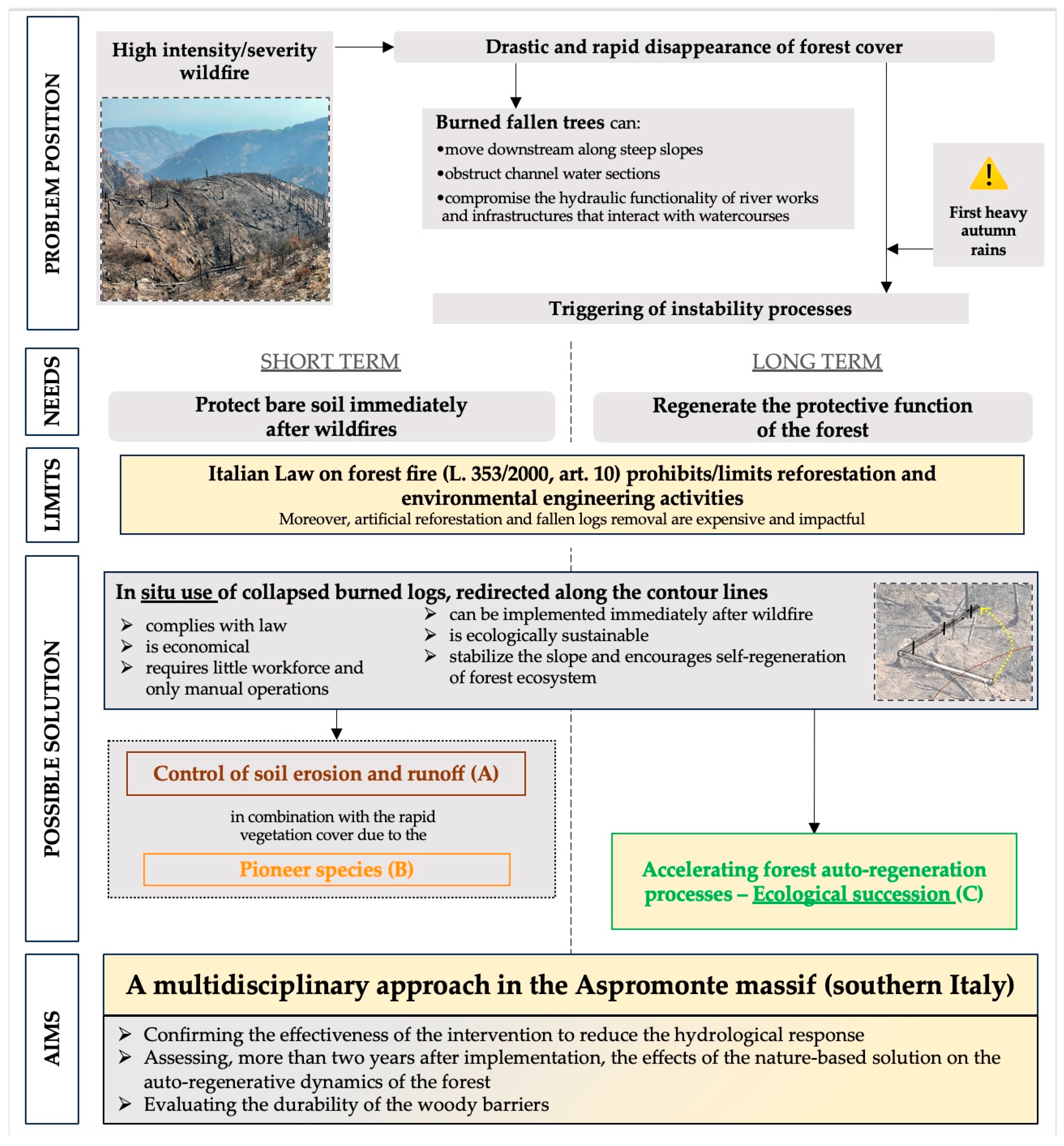

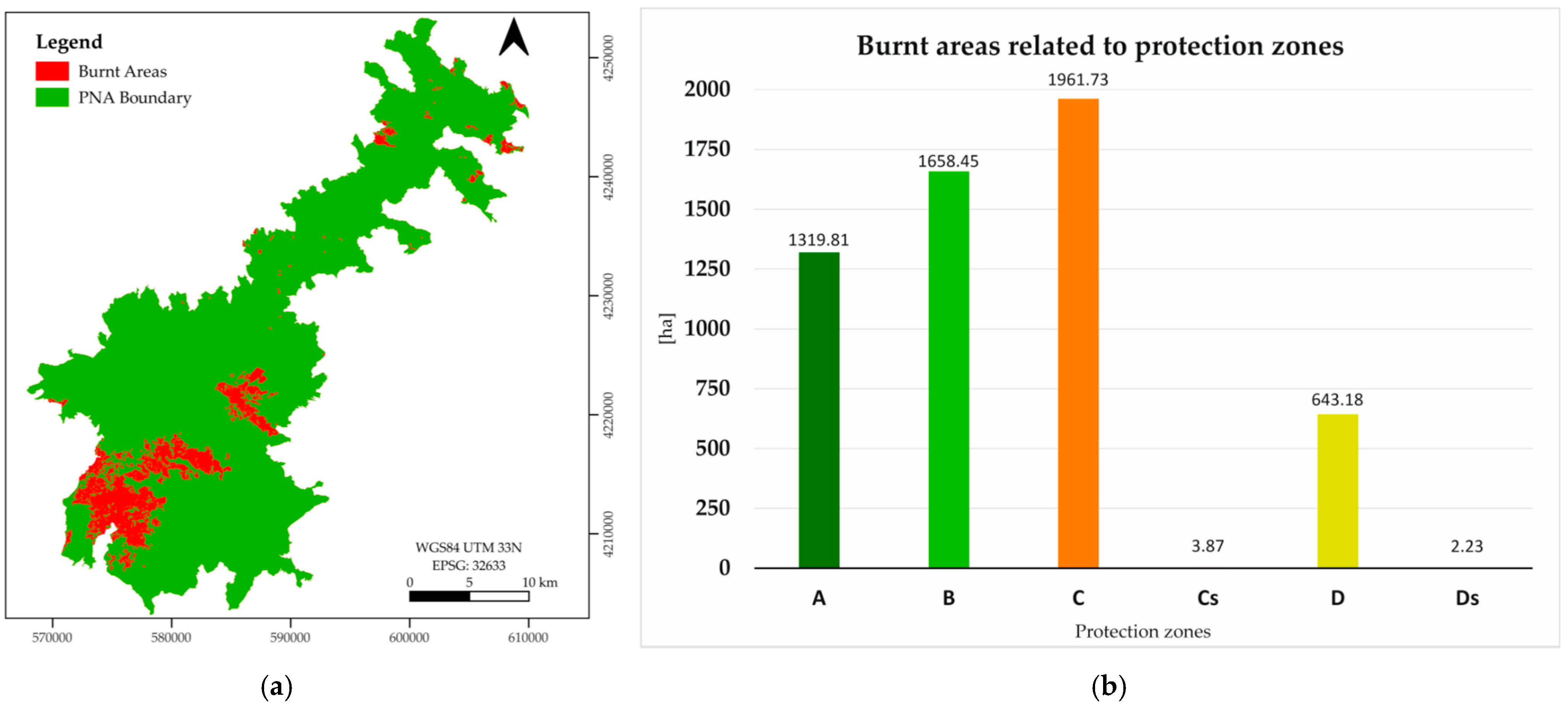
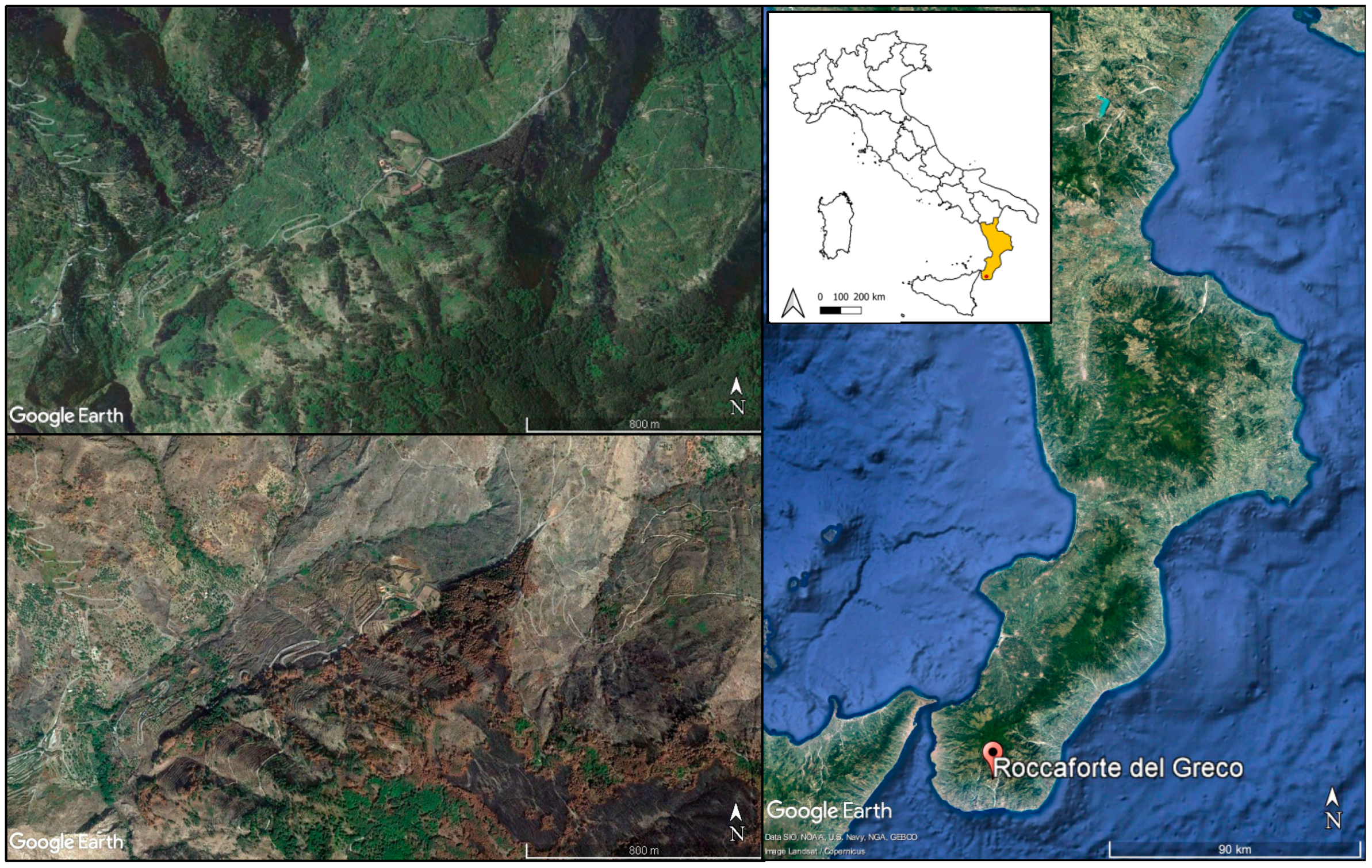
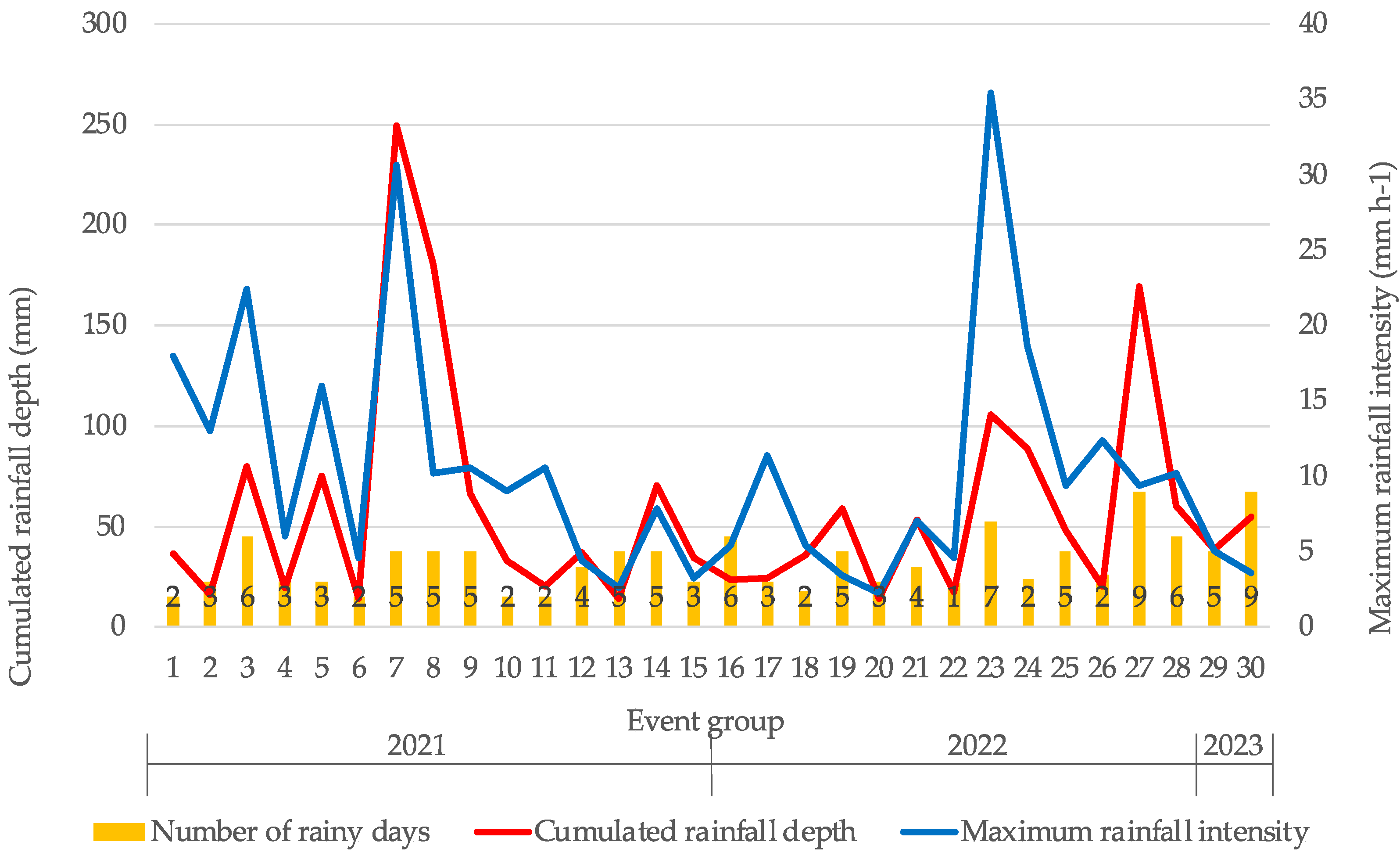
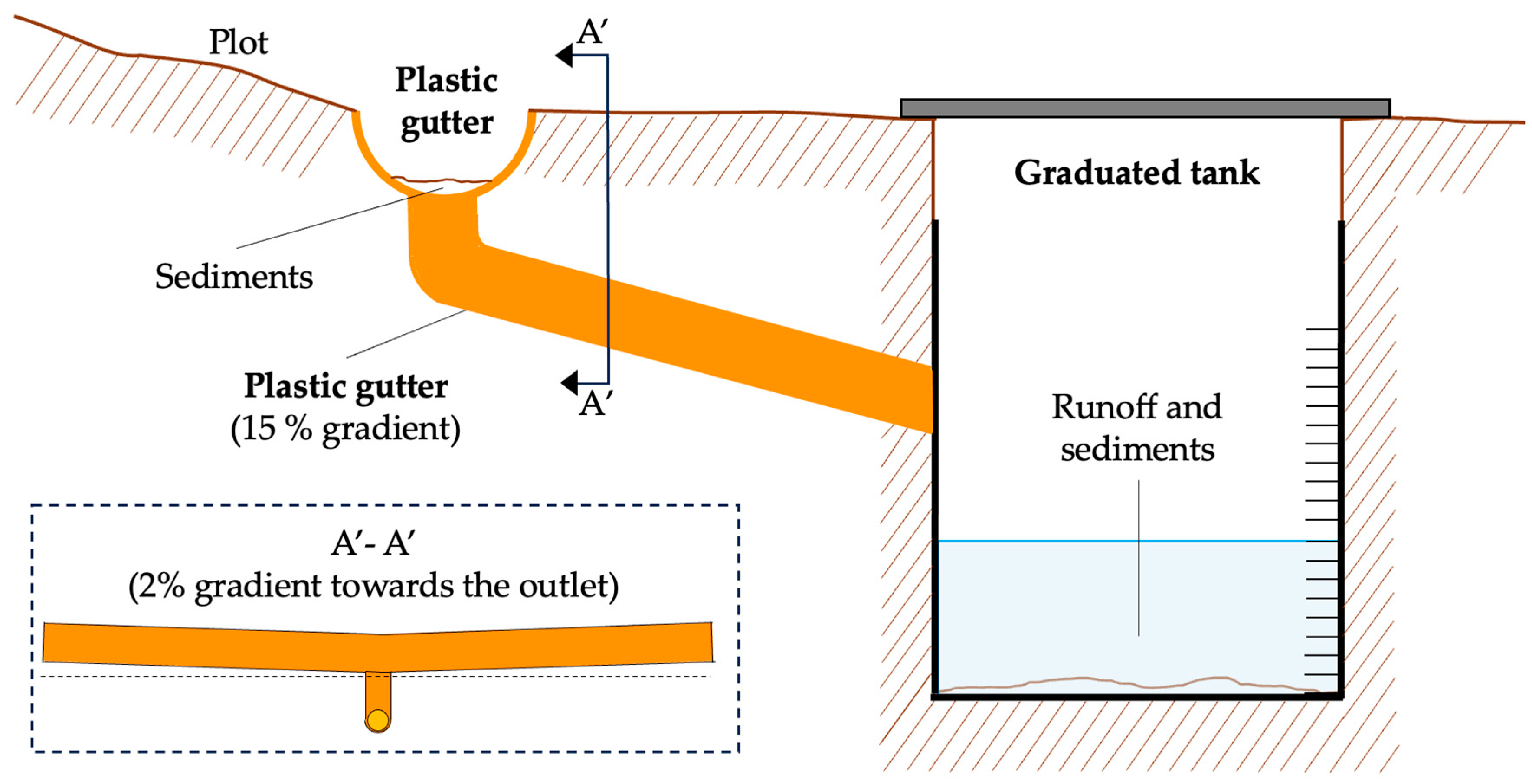
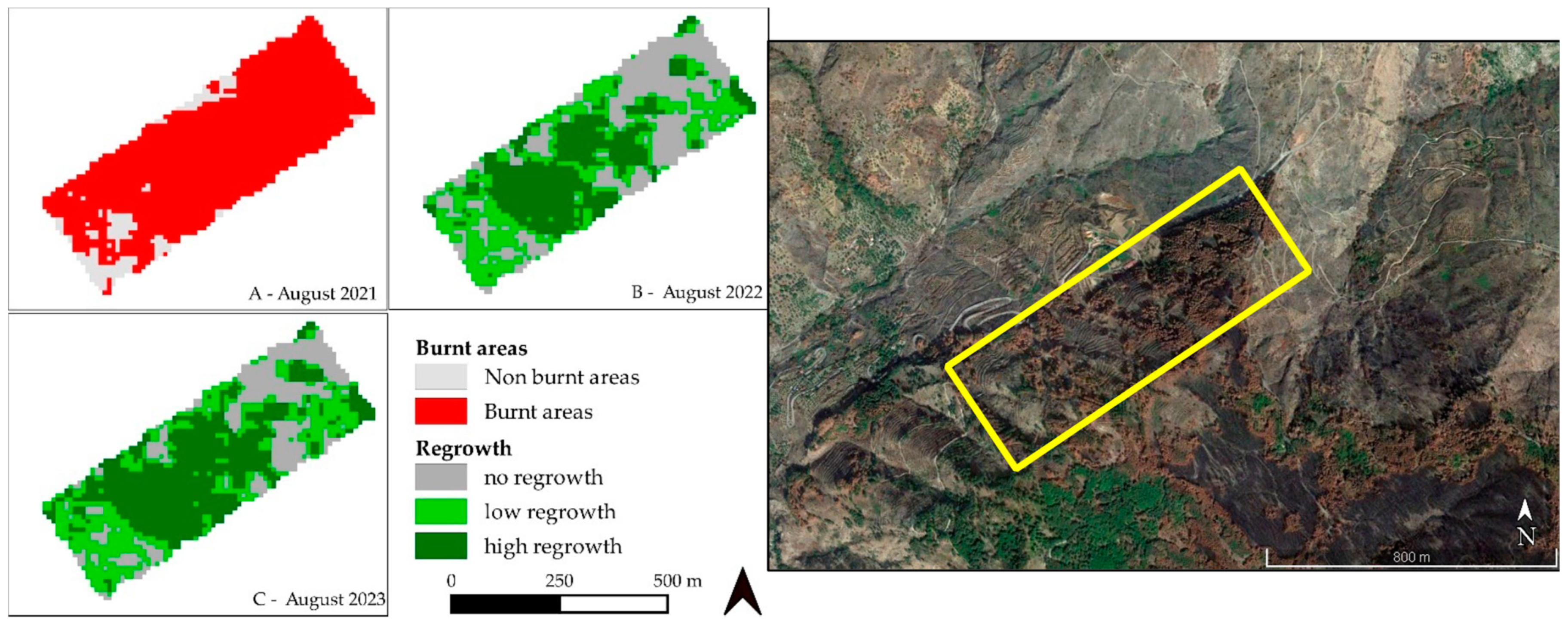
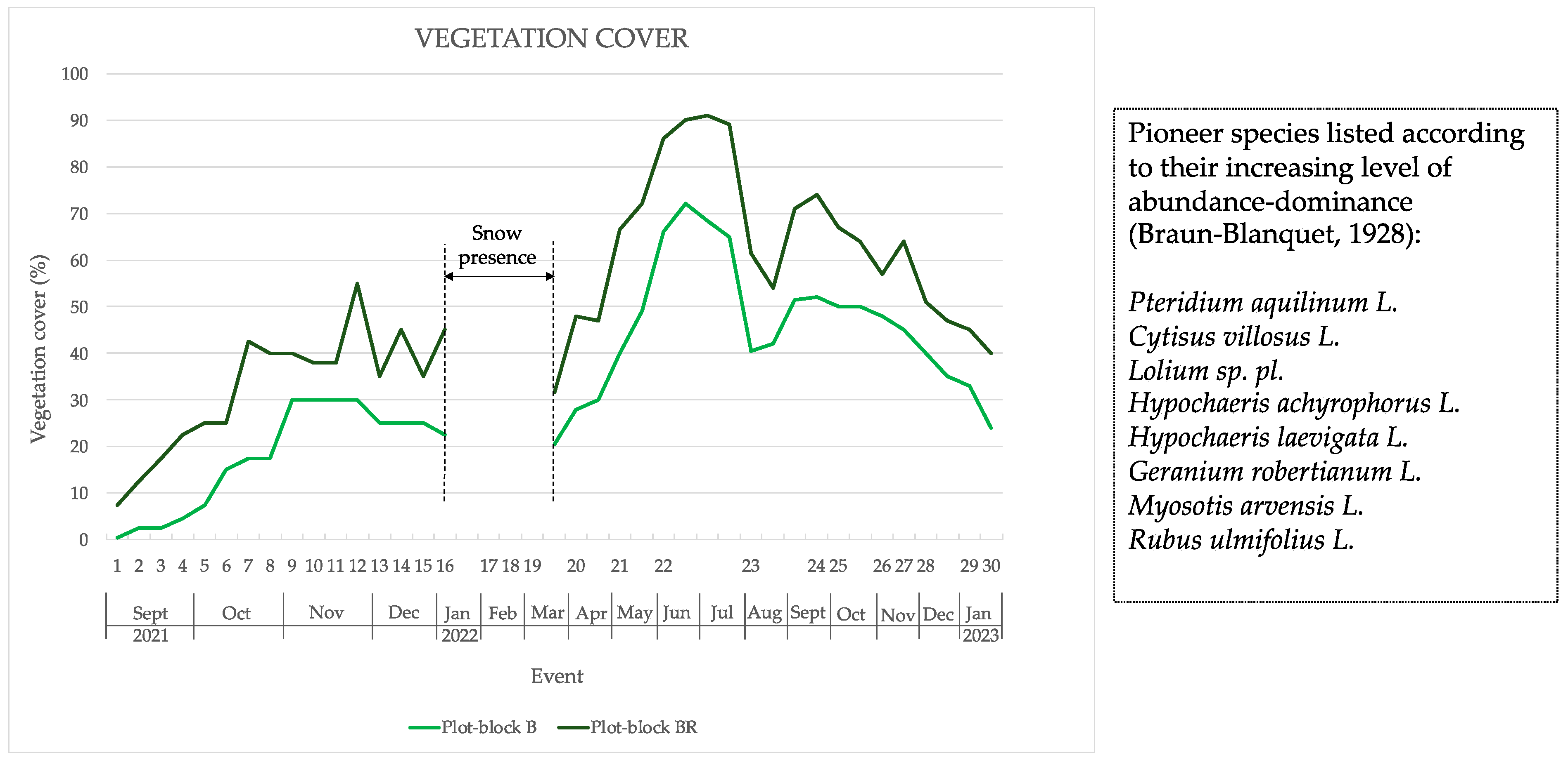
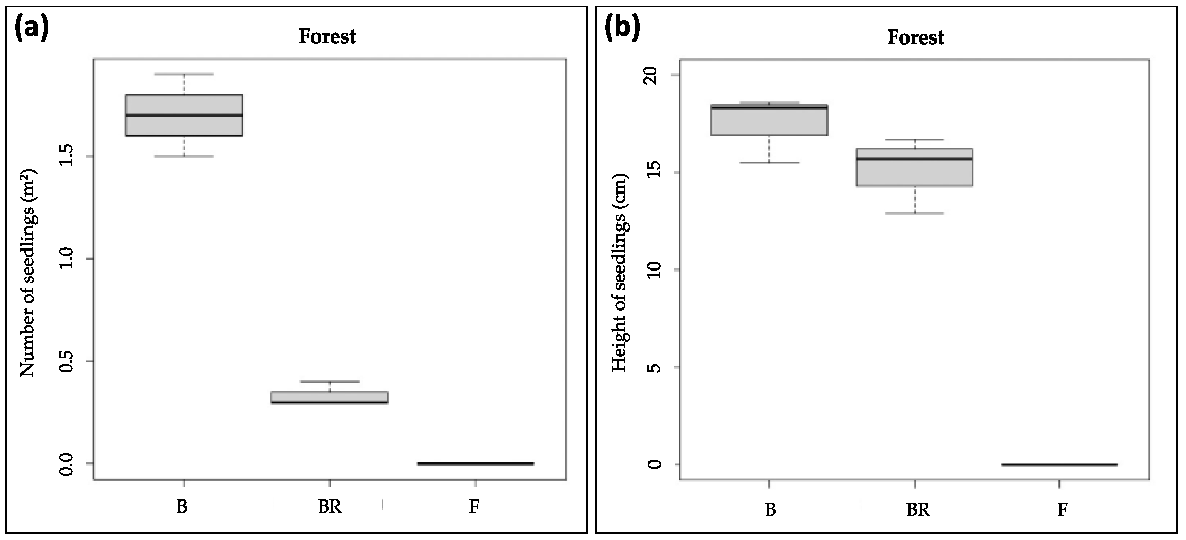
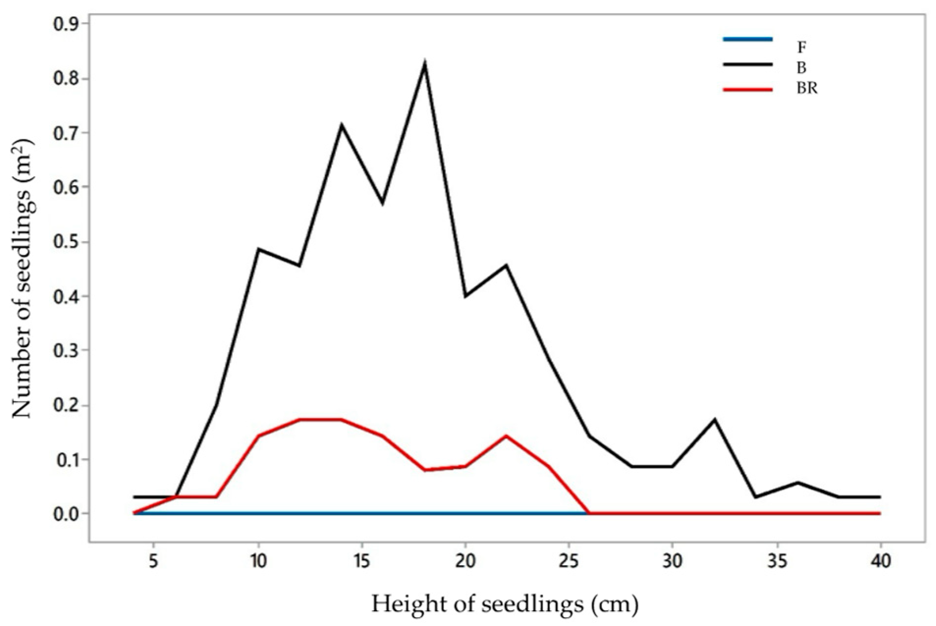
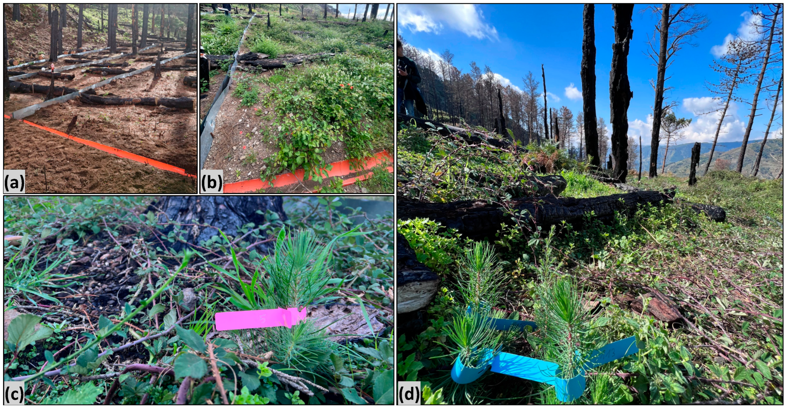
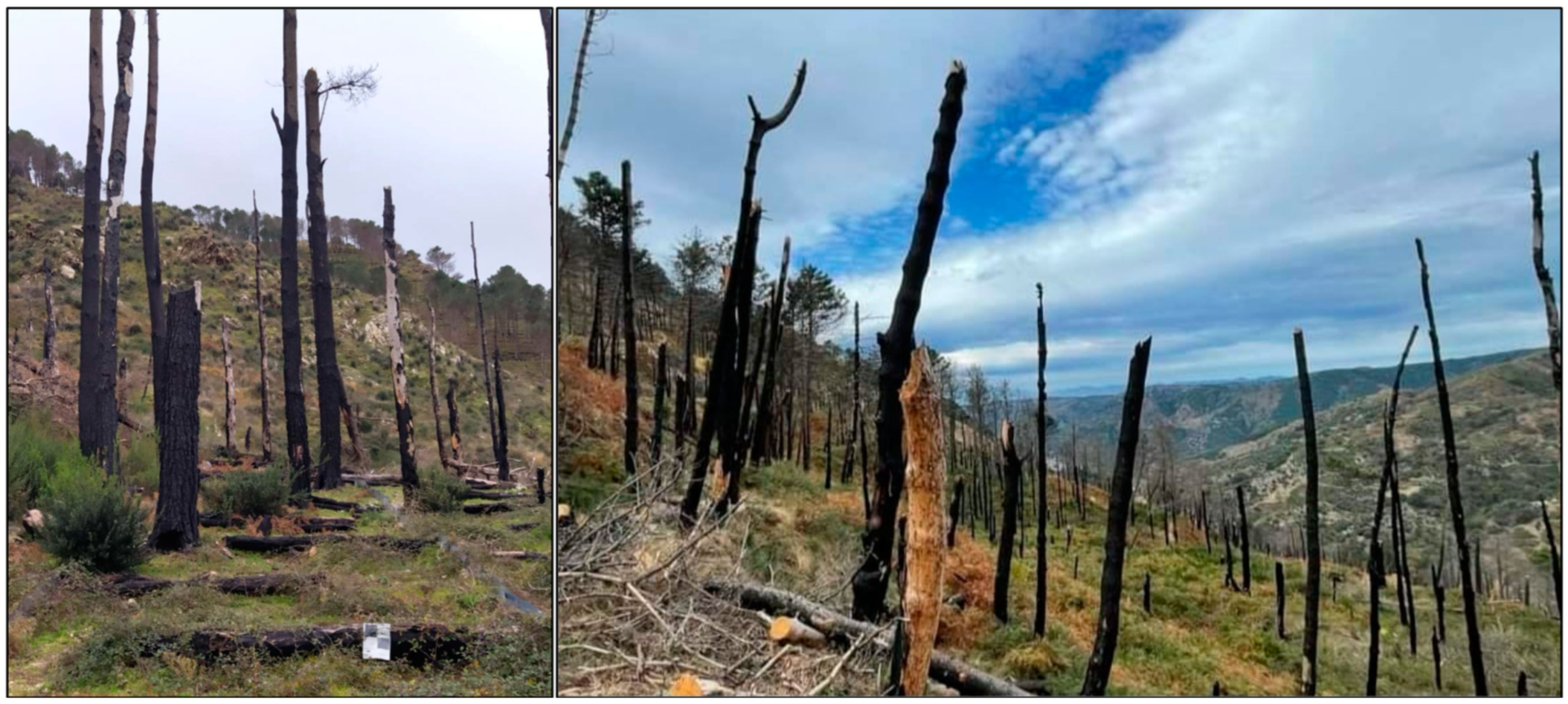
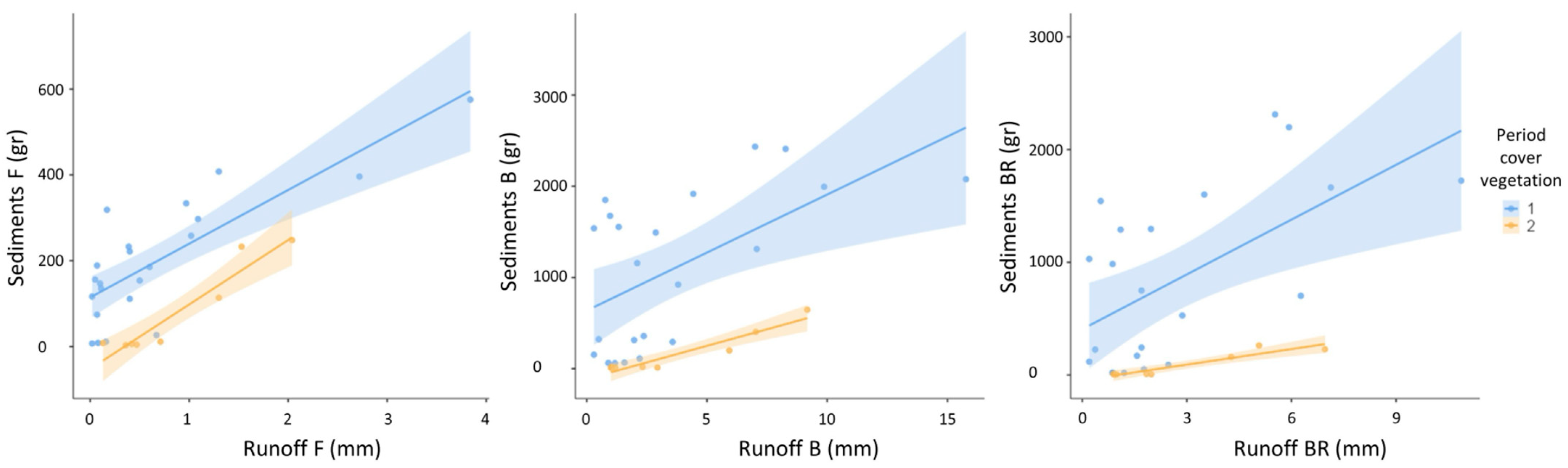
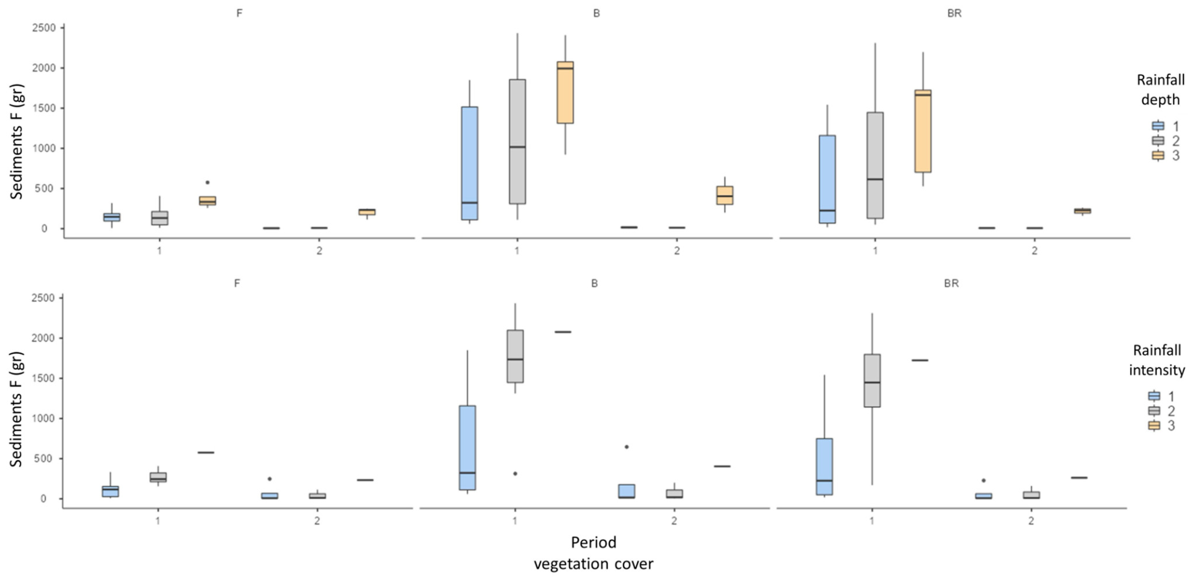
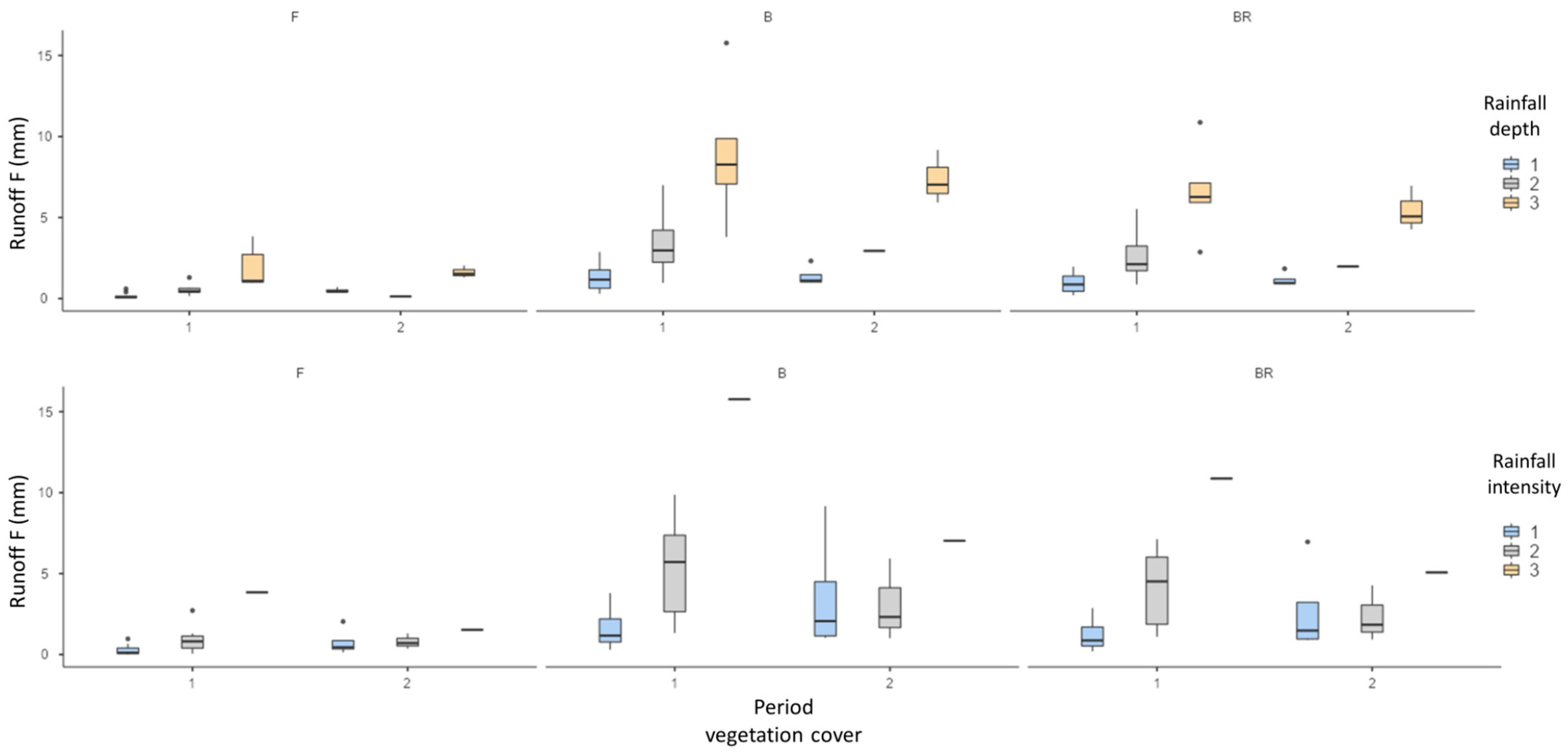
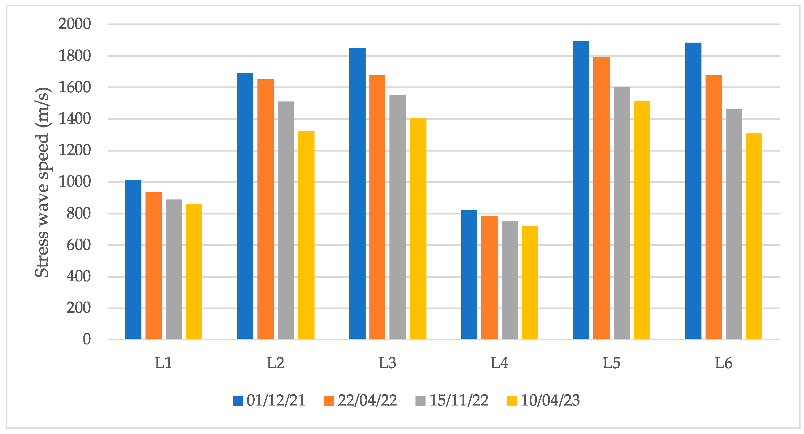

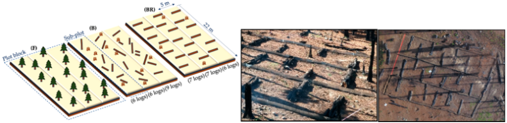
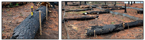
Disclaimer/Publisher’s Note: The statements, opinions and data contained in all publications are solely those of the individual author(s) and contributor(s) and not of MDPI and/or the editor(s). MDPI and/or the editor(s) disclaim responsibility for any injury to people or property resulting from any ideas, methods, instructions or products referred to in the content. |
© 2024 by the authors. Licensee MDPI, Basel, Switzerland. This article is an open access article distributed under the terms and conditions of the Creative Commons Attribution (CC BY) license (https://creativecommons.org/licenses/by/4.0/).