
Managing Landscape Urbanization and Assessing Biodiversity of Wildlife Habitats: A Study of Bobcats in San Jose, California

Abstract
1. Introduction
2. Literature Review
2.1. Biodiversity Conservation
2.2. Genetic Connectivity
2.3. Road Safety
2.4. Urban Ecology
2.5. Interdisciplinary Collaboration
3. Materials and Methods
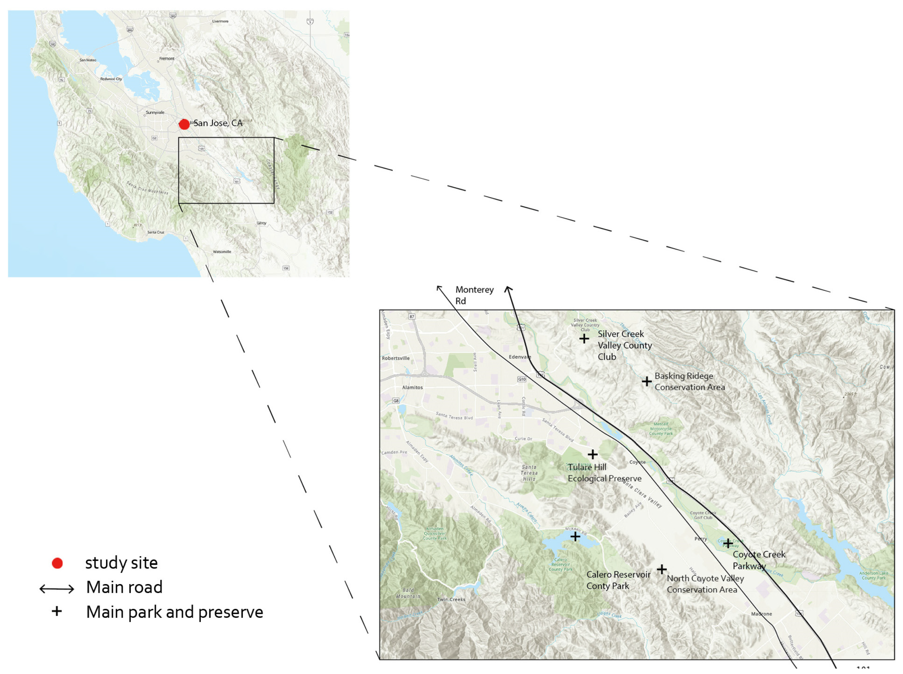
3.1. Study Site
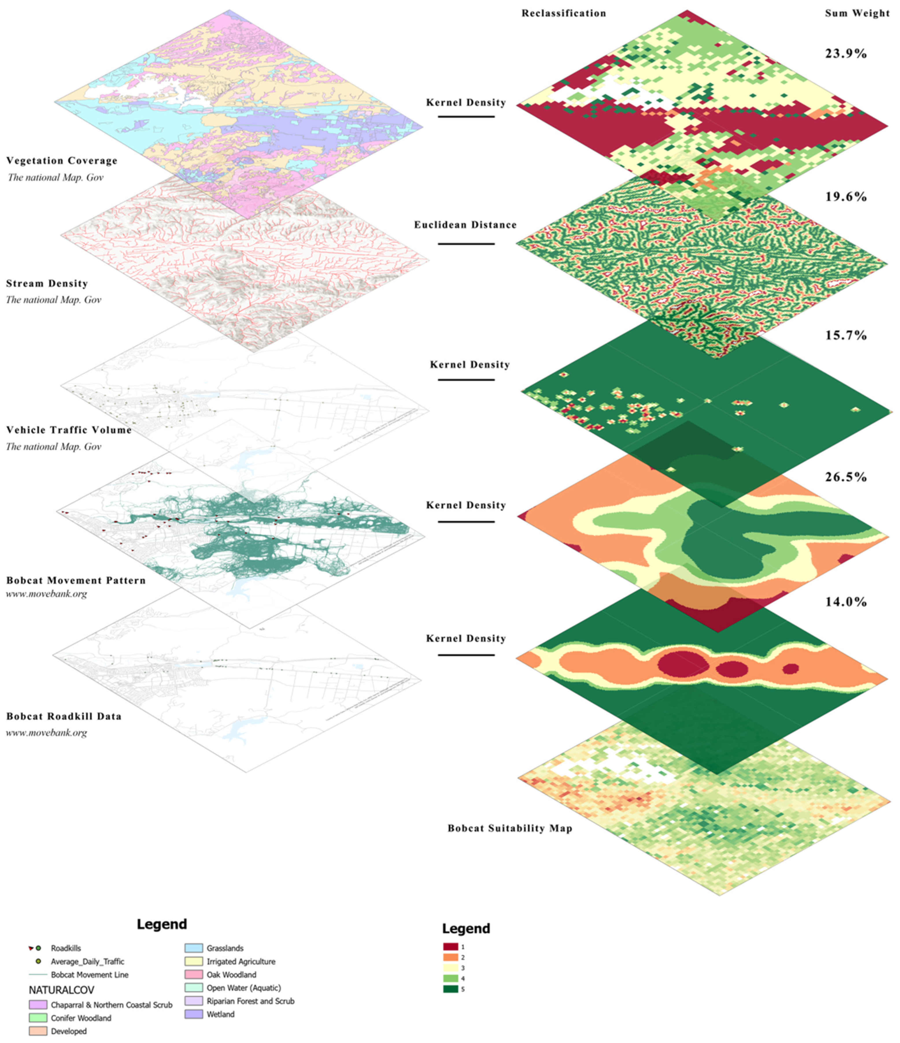
3.2. Data Sources and Scoring
3.3. Data Analysis Criteria of Habitat Suitability Modeling (HSM)
3.3.1. Kernel Density
3.3.2. Euclidean Distance
4. Results
4.1. Vegetation Coverage (Sum Weight: 23.9%)
4.2. Distance to Stream (Weight: 19.6%)
4.3. Traffic Volume (Weight: 15.7%)
4.4. Bobcat Movement Patterns (Weight: 26.8%)
4.5. Bobcat Roadkill (Weight: 14.0%)
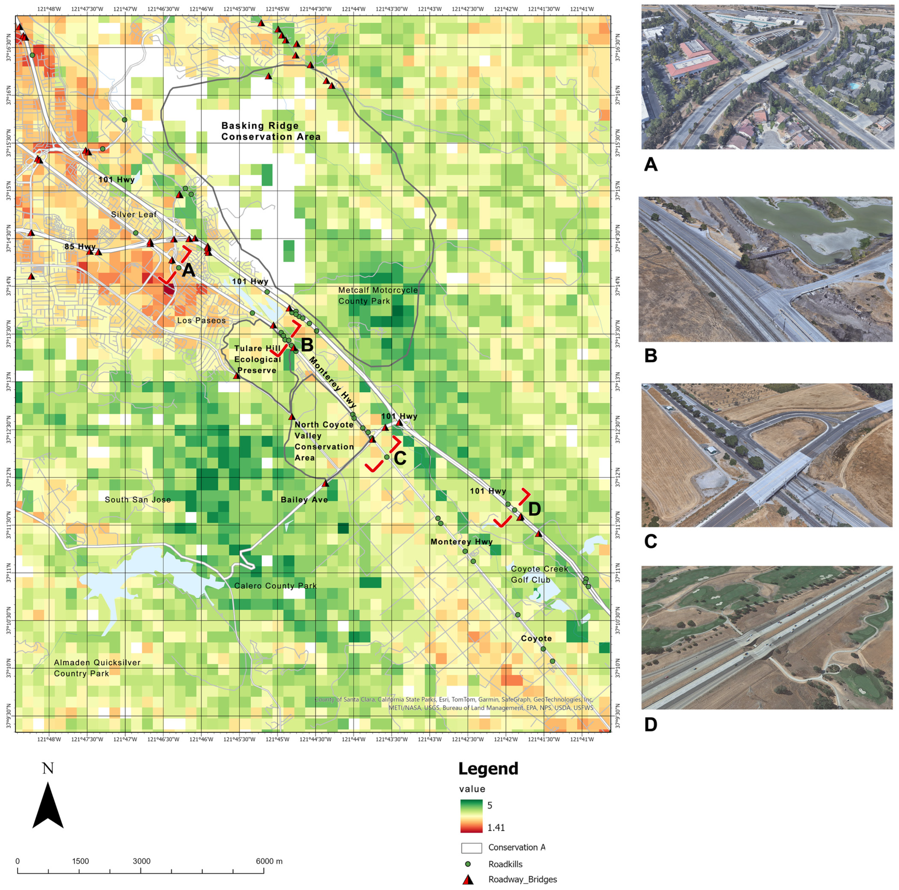
4.6. Habitat Suitability Modeling (HSM)
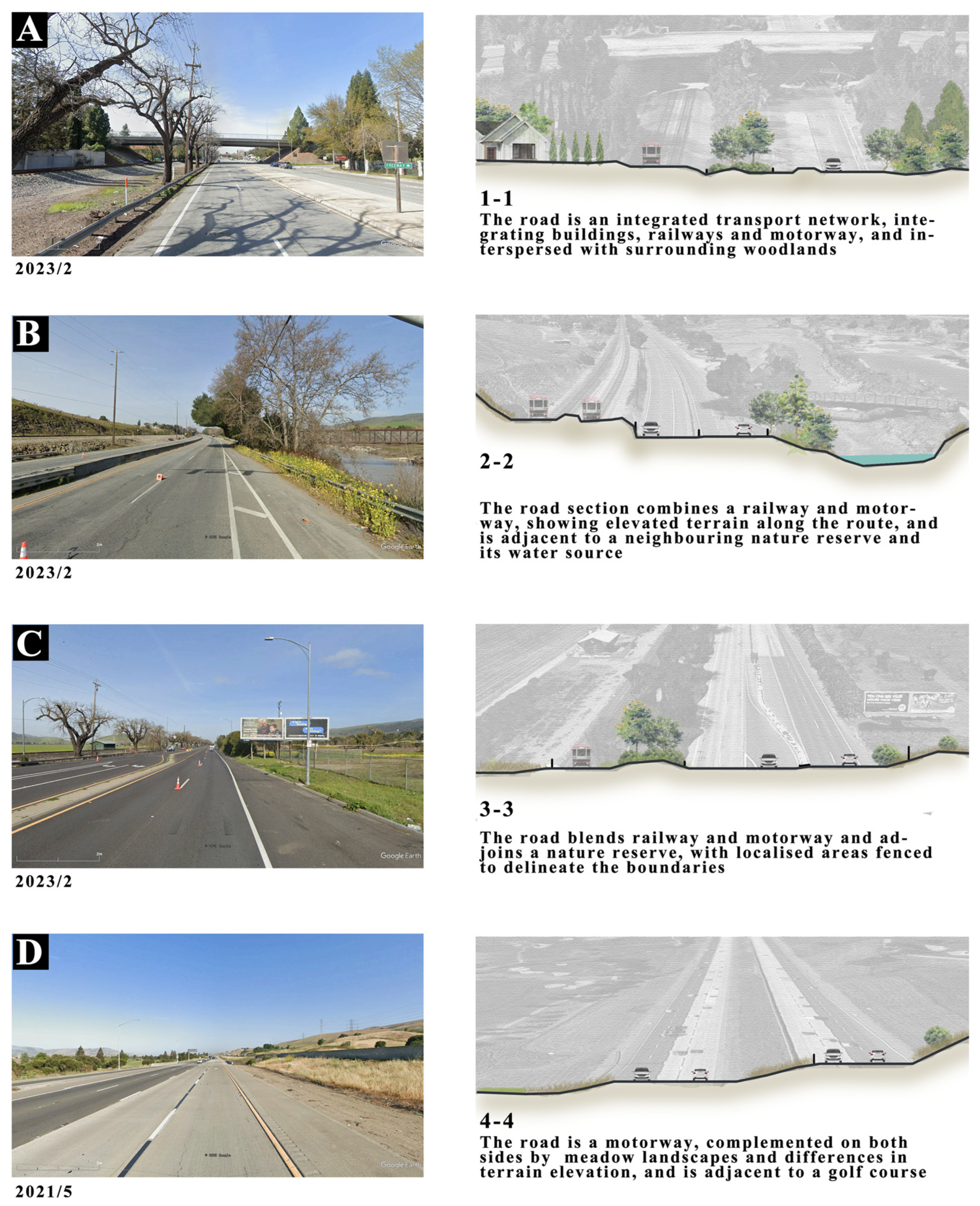
5. Discussion
6. Limitations
7. Conclusions
Author Contributions
Funding
Data Availability Statement
Conflicts of Interest
References
- Rytwinski, T.; Soanes, K.; Jaeger, J.A.G.; Fahrig, L.; Findlay, C.S.; Houlahan, J.; van der Ree, R.; van der Grift, E.A. How Effective Is Road Mitigation at Reducing Road-Kill? A Meta-Analysis. PLoS ONE 2016, 11, e0166941. [Google Scholar] [CrossRef]
- Shepherd, B.J.; Houck, J.; Lyon, C. On the Road Again: A Study Valuing Wildlife Crossings for Wetland Mitigation on State Road 40 in Volusia County, Florida. Ecosphere 2023, 14, e4566. [Google Scholar] [CrossRef]
- Kaczensky, P.; Knauer, F.; Krze, B.; Jonozovic, M.; Adamic, M.; Gossow, H. The Impact of High Speed, High Volume Traffic Axes on Brown Bears in Slovenia. Biol. Conserv. 2003, 111, 191–204. [Google Scholar] [CrossRef]
- Bruschi, D.; Astiaso Garcia, D.; Gugliermetti, F.; Cumo, F. Characterizing the Fragmentation Level of Italian’s National Parks Due to Transportation Infrastructures. Transp. Res. Part D Transp. Environ. 2015, 36, 18–28. [Google Scholar] [CrossRef]
- Blanton, P. The Distribution and Impact of Roads and Railroads on the River Landscapes of the Coterminous United States. Ph.D. Thesis, University of Oregon, Eugene, OR, USA, 2010. Available online: https://www.proquest.com/openview/addc5907d5aa2fcf4559e21e9c48af62/1?pq-origsite=gscholar&cbl=18750 (accessed on 13 January 2024).
- Tarabon, S.; Godet, C.; Coskun, T.; Clauzel, C. Coupling Spatial Modeling with Expert Opinion Approaches to Restore Multispecies Connectivity of Major Transportation Infrastructure. Landsc. Urban Plan. 2022, 221, 104371. [Google Scholar] [CrossRef]
- Tatewaki, T.; Koike, F. An Overview of Roadkill Records on Japanese Municipalities Revealed by a Questionnaire Survey. Wildl. Hum. Soc. 2016, 3, 15–28. [Google Scholar] [CrossRef]
- Vickers, T.W.; Sanchez, J.N.; Johnson, C.K.; Morrison, S.A.; Botta, R.; Smith, T.; Cohen, B.S.; Huber, P.R.; Ernest, H.B.; Boyce, W.M. Survival and Mortality of Pumas (Puma concolor) in a Fragmented, Urbanizing Landscape. PLoS ONE 2015, 10, e0131490. [Google Scholar] [CrossRef]
- Carroll, C.; Hartl, B.; Goldman, G.T.; Rohlf, D.J.; Treves, A.; Kerr, J.T.; Ritchie, E.G.; Kingsford, R.T.; Gibbs, K.E.; Maron, M.; et al. Defending the Scientific Integrity of Conservation-Policy Processes. Conserv. Biol. 2017, 31, 967–975. [Google Scholar] [CrossRef]
- Larrucea, E.S.; Serra, G.; Jaeger, M.M.; Barrett, R.H. Censusing Bobcats Using Remote Cameras. West. N. Am. Nat. 2007, 67, 538–548. [Google Scholar] [CrossRef]
- Reed, G.C.; Litvaitis, J.A.; Callahan, C.; Carroll, R.P.; Litvaitis, M.K.; Broman, D.J.A. Modeling Landscape Connectivity for Bobcats Using Expert-Opinion and Empirically Derived Models: How Well Do They Work? Anim. Conserv. 2017, 20, 308–320. [Google Scholar] [CrossRef]
- Riley, S.P.D. Spatial Ecology of Bobcats and Gray Foxes in Urban and Rural Zones of a National Park. J. Wildl. Manag. 2006, 70, 1425–1435. [Google Scholar] [CrossRef]
- Riley, S.; Sauvajot, R.; Fuller, T.; York, E.; Kamradt, D.; Bromley, C.; Wayne, R. Effects of Urbanization and Habitat Fragmentation on Bobcats and Coyotes in Southern California. Conserv. Biol. 2003, 17, 566–576. [Google Scholar] [CrossRef]
- Mimet, A.; Clauzel, C.; Foltête, J.-C. Locating Wildlife Crossings for Multispecies Connectivity across Linear Infrastructures. Landsc. Ecol. 2016, 31, 1955–1973. [Google Scholar] [CrossRef]
- Zeller, K.A.; Wattles, D.W.; Conlee, L.; Destefano, S. Response of Female Black Bears to a High-Density Road Network and Identification of Long-Term Road Mitigation Sites. Anim. Conserv. 2021, 24, 167–180. [Google Scholar] [CrossRef]
- Forman, R.T.T.; Alexander, L.E. Roads and Their Major Ecological Effects. Annu. Rev. Ecol. Syst. 1998, 29, 207–231. [Google Scholar] [CrossRef]
- Serieys, L.E.K.; Rogan, M.S.; Matsushima, S.S.; Wilmers, C.C. Road-Crossings, Vegetative Cover, Land Use and Poisons Interact to Influence Corridor Effectiveness. Biol. Conserv. 2021, 253, 108930. [Google Scholar] [CrossRef]
- Torres, A.; Jaeger, J.A.G.; Alonso, J.C. Assessing Large-Scale Wildlife Responses to Human Infrastructure Development. Proc. Natl. Acad. Sci. USA 2016, 113, 8472–8477. [Google Scholar] [CrossRef]
- Lewis, J.S.; Logan, K.A.; Alldredge, M.W.; Bailey, L.L.; VandeWoude, S.; Crooks, K.R. The Effects of Urbanization on Population Density, Occupancy, and Detection Probability of Wild Felids. Ecol. Appl. 2015, 25, 1880–1895. [Google Scholar] [CrossRef]
- Sergio, F.; Newton, I.; Marchesi, L. Conservation: Top Predators and Biodiversity. Nature 2005, 436, 192. [Google Scholar] [CrossRef] [PubMed]
- Newbury, R.K.; Hodges, K.E. Regional Differences in Winter Diets of Bobcats in Their Northern Range. Ecol. Evol. 2018, 8, 11100–11110. [Google Scholar] [CrossRef]
- Jones, L.R.; Johnson, S.A.; Hudson, C.M.; Zollner, P.A.; Swihart, R.K. Habitat Selection in a Recovering Bobcat (Lynx rufus) Population. PLoS ONE 2022, 17, e0269258. [Google Scholar] [CrossRef]
- Fischer, J.D.; Cleeton, S.H.; Lyons, T.P.; Miller, J.R. Urbanization and the Predation Paradox: The Role of Trophic Dynamics in Structuring Vertebrate Communities. BioScience 2012, 62, 809–818. [Google Scholar] [CrossRef]
- Leighton, G.R.M.; Froneman, W.; Serieys, L.E.K.; Bishop, J.M. Trophic Downgrading of an Adaptable Carnivore in an Urbanising Landscape. Sci. Rep. 2023, 13, 21582. [Google Scholar] [CrossRef] [PubMed]
- Rubalcava-Castillo, F.A.; Sosa-Ramírez, J.; Luna-Ruíz, J.J.; Valdivia-Flores, A.G.; Díaz-Núñez, V.; Íñiguez-Dávalos, L.I. Endozoochorous Dispersal of Forest Seeds by Carnivorous Mammals in Sierra Fría, Aguascalientes, Mexico. Ecol. Evol. 2020, 10, 2991–3003. [Google Scholar] [CrossRef]
- Rubalcava-Castillo, F.A.; Sosa-Ramírez, J.; de Jesús Luna-Ruíz, J.; Valdivia-Flores, A.G.; Íñiguez-Dávalos, L.I. Seed Dispersal by Carnivores in Temperate and Tropical Dry Forests. Ecol. Evol. 2021, 11, 3794–3807. [Google Scholar] [CrossRef] [PubMed]
- Millions, D.G.; Swanson, B.J. Impact of Natural and Artificial Barriers to Dispersal on the Population Structure of Bobcats. J. Wildl. Manag. 2007, 71, 96–102. [Google Scholar] [CrossRef]
- Ruell, E.W.; Riley, S.P.D.; Douglas, M.R.; Antolin, M.F.; Pollinger, J.R.; Tracey, J.A.; Lyren, L.M.; Boydston, E.E.; Fisher, R.N.; Crooks, K.R. Urban Habitat Fragmentation and Genetic Population Structure of Bobcats in Coastal Southern California. Am. Midl. Nat. 2012, 168, 265–280. [Google Scholar] [CrossRef]
- Reding, D.M.; Bronikowski, A.M.; Johnson, W.E.; Clark, W.R. Pleistocene and Ecological Effects on Continental-Scale Genetic Differentiation in the Bobcat (Lynx rufus). Mol. Ecol. 2012, 21, 3078–3093. [Google Scholar] [CrossRef] [PubMed]
- Serieys, L.E.K.; Lea, A.; Pollinger, J.P.; Riley, S.P.D.; Wayne, R.K. Disease and Freeways Drive Genetic Change in Urban Bobcat Populations. Evol. Appl. 2015, 8, 75–92. [Google Scholar] [CrossRef]
- Nielsen, C.K.; Woolf, A. Survival of Unexploited Bobcats in Southern Illinois. J. Wildl. Manag. 2002, 66, 833–838. [Google Scholar] [CrossRef]
- França Balbino Da Silva, A.C.; Fernando Saraiva De Menezes, J.; Rodrigues Oliveira Santos, L.G. Roadkill Risk for Capybaras in an Urban Environment. Landsc. Urban Plan. 2022, 222, 104398. [Google Scholar] [CrossRef]
- Sprem, N.; Duduković, D.; Keros, T.; Konjevic, D. Wildlife-Vehicle Collisions in Croatia—A Hazard for Humans and Animals. Coll. Antropol. 2013, 37, 531–535. Available online: https://www.researchgate.net/publication/255910368_Wildlife-vehicle_collisions_in_Croatia_-_A_hazard_for_humans_and_animals (accessed on 13 January 2024). [PubMed]
- Rose, N.; Prange, S.; Landry, S. Extirpated, Immigrated, Genetically Stratified—First Demographic Assessment of a Recovering Bobcat (Lynx rufus) Population after a Century of Extinction. Mammal Res. 2020, 65, 423–434. [Google Scholar] [CrossRef]
- Bencin, H.L.; Prange, S.; Rose, C.; Popescu, V.D. Roadkill and Space Use Data Predict Vehicle-Strike Hotspots and Mortality Rates in a Recovering Bobcat (Lynx rufus) Population. Sci. Rep. 2019, 9, 15391. [Google Scholar] [CrossRef] [PubMed]
- Clevenger, A.P.; Waltho, N. Performance Indices to Identify Attributes of Highway Crossing Structures Facilitating Movement of Large Mammals. Biol. Conserv. 2005, 121, 453–464. [Google Scholar] [CrossRef]
- Ng, S.J.; Dole, J.W.; Sauvajot, R.M.; Riley, S.P.D.; Valone, T.J. Use of Highway Undercrossings by Wildlife in Southern California. Biol. Conserv. 2004, 115, 499–507. [Google Scholar] [CrossRef]
- Caldwell, M.R.; Klip, J.M.K. Wildlife Interactions within Highway Underpasses. J. Wildl. Manag. 2019, 84, 227–236. [Google Scholar] [CrossRef]
- Caldwell, M.R.; Klip, J.M.K. Mule Deer Migrations and Highway Underpass Usage in California, USA. J. Wildl. Manag. 2021, 85, 880–886. [Google Scholar] [CrossRef]
- Lewis, J.S.; Rachlow, J.L.; Horne, J.S.; Garton, E.O.; Wakkinen, W.L.; Hayden, J.; Zager, P. Identifying Habitat Characteristics to Predict Highway Crossing Areas for Black Bears within a Human-Modified Landscape. Landsc. Urban Plan. 2011, 101, 99–107. [Google Scholar] [CrossRef]
- Wierucka, K.; Hatten, C.E.; Murphy, D.; Allcock, J.A.; Andersson, A.A.; Bojan, J.W.; Kong, T.C.; Kwok, J.K.; Lam, J.Y.; Ma, C.H.; et al. Human-Wildlife Interactions in Urban Asia. Glob. Ecol. Conserv. 2023, 46, e02596. [Google Scholar] [CrossRef]
- Sperling, D.; Bissonette, J.A.; Clevenger, A.P. Road Ecology: Science and Solutions; Island Press: Washington, DC, USA, 2003. [Google Scholar]
- Kay, C.A.M.; Rohnke, A.T.; Sander, H.A.; Stankowich, T.; Fidino, M.; Murray, M.H.; Lewis, J.S.; Taves, I.; Lehrer, E.W.; Zellmer, A.J.; et al. Barriers to Building Wildlife-inclusive Cities: Insights from the Deliberations of Urban Ecologists, Urban Planners and Landscape Designers. People Nat. 2022, 4, 62–70. [Google Scholar] [CrossRef]
- Paquet, P.C.; Darimont, C.T. Wildlife Conservation and Animal Welfare: Two Sides of the Same Coin? Anim. Welf. 2010, 19, 177–190. [Google Scholar] [CrossRef]
- Blair, M.E.; Le, M.D.; Sethi, G.; Thach, H.M.; Nguyen, V.T.H.; Amato, G.; Birchette, M.; Sterling, E.J. Importance of an Interdisciplinary Research Approach to Inform Wildlife Trade Management in Southeast Asia. BioScience 2017, 67, 995–1003. [Google Scholar] [CrossRef]
- Rice, A.H. Interdisciplinary Collaboration in Health Care: Education, Practice, and Research. Natl. Acad. Pract. Forum Issues Interdiscip. Care 2000, 2, 59–73. [Google Scholar]
- Kirk, H.; Soanes, K.; Amati, M.; Bekessy, S.; Harrison, L.; Parris, K.; Ramalho, C.; van de Ree, R.; Threlfall, C. Ecological Connectivity as a Planning Tool for the Conservation of Wildlife in Cities. ScienceDirect 2013, 10, 101989. [Google Scholar] [CrossRef] [PubMed]
- Hirzel, A.H.; Le Lay, G. Habitat Suitability Modelling and Niche Theory. J. Appl. Ecol. 2008, 45, 1372–1381. [Google Scholar] [CrossRef]
- Shen, X.; Handel, S.N.; Kirkwood, N.G.; Huang, Y.; Padua, M.G. Locating the Responsive Plants for Landscape Recovery: A Toolkit for Designers and Planners. Ecol. Restor. 2022, 40, 33–35. [Google Scholar] [CrossRef]
- Muhammed, K.; Anandhi, A.; Chen, G. Comparing Methods for Estimating Habitat Suitability. Land 2022, 11, 1754. [Google Scholar] [CrossRef]
- Bellamy, C.; Boughey, K.; Hawkins, C.; Reveley, S.; Spake, R.; Williams, C.; Altringham, J. A Sequential Multi-Level Framework to Improve Habitat Suitability Modelling. Landsc. Ecol. 2020, 35, 1001–1020. [Google Scholar] [CrossRef]
- Eared-Pheasant, B. Model to Assess the Habitat Suitability for Endangered Bird Species: Brown Eared Pheasant Crossoptilon Mantchuricum Swinhoe in Xiaowutaishan Reserve, China. Pol. J. Ecol. 2008, 56, 723–729. [Google Scholar]
- de Oliveira Averna Valente, R.; Vettorazzi, C.A. Definition of Priority Areas for Forest Conservation through the Ordered Weighted Averaging Method. For. Ecol. Manag. 2008, 256, 1408–1417. [Google Scholar] [CrossRef]
- Osaragi, T. Classification Methods for Spatial Data Representation; University College London: London, UK, 2008. [Google Scholar]
- Pettit, C.J.; Klosterman, R.E.; Delaney, P.; Whitehead, A.L.; Kujala, H.; Bromage, A.; Nino-Ruiz, M. The Online What If? Planning Support System: A Land Suitability Application in Western Australia. Appl. Spat. Anal. 2015, 8, 93–112. [Google Scholar] [CrossRef]
- Data Classification Methods—ArcGIS Pro. Available online: https://pro.arcgis.com/en/pro-app/latest/help/mapping/layer-properties/data-classification-methods.htm (accessed on 21 November 2023).
- Store, R.; Kangas, J. Integrating Spatial Multi-Criteria Evaluation and Expert Knowledge for GIS-Based Habitat Suitability Modelling. Landsc. Urban Plan. 2001, 55, 79–93. [Google Scholar] [CrossRef]
- Dong, J.; Peng, J.; Liu, Y.; Qiu, S.; Han, Y. Integrating Spatial Continuous Wavelet Transform and Kernel Density Estimation to Identify Ecological Corridors in Megacities. Landsc. Urban Plan. 2020, 199, 103815. [Google Scholar] [CrossRef]
- Delso, J.; Martin, B.; Ortega, E.; Van De Weghe, N. Integrating Pedestrian-Habitat Models and Network Kernel Density Estimations to Measure Street Pedestrian Suitability. Sustain. Cities Soc. 2019, 51, 101736. [Google Scholar] [CrossRef]
- Kaszta, Ż.; Cushman, S.A.; Macdonald, D.W. Prioritizing Habitat Core Areas and Corridors for a Large Carnivore across Its Range. Anim. Conserv. 2020, 23, 607–616. [Google Scholar] [CrossRef]
- Lyon, K.; Cottrell, S.P.; Siikamäki, P.; Van Marwijk, R. Biodiversity Hotspots and Visitor Flows in Oulanka National Park, Finland. Scand. J. Hosp. Tour. 2011, 11, 100–111. [Google Scholar] [CrossRef]
- Chamling, M.; Bera, B. Likelihood of Elephant Death Risk Applying Kernel Density Estimation Model along the Railway Track within Biodiversity Hotspot of Bhutan–Bengal Himalayan Foothill. Model. Earth Syst. Environ. 2020, 6, 2565–2580. [Google Scholar] [CrossRef]
- Cushman, S.A.; Elliot, N.B.; Bauer, D.; Kesch, K.; Bahaa-El-Din, L.; Bothwell, H.; Flyman, M.; Mtare, G.; Macdonald, D.W.; Loveridge, A.J. Prioritizing Core Areas, Corridors and Conflict Hotspots for Lion Conservation in Southern Africa. PLoS ONE 2018, 13, e0196213. [Google Scholar] [CrossRef]
- Cantrell, D.L.; Rees, E.E.; Vanderstichel, R.; Grant, J.; Filgueira, R.; Revie, C.W. The Use of Kernel Density Estimation with a Bio-Physical Model Provides a Method to Quantify Connectivity among Salmon Farms: Spatial Planning and Management with Epidemiological Relevance. Front. Vet. Sci. 2018, 5, 269. [Google Scholar] [CrossRef]
- How Kernel Density Works—ArcGIS Pro. Available online: https://pro.arcgis.com/en/pro-app/latest/tool-reference/spatial-analyst/how-kernel-density-works.htm (accessed on 1 December 2023).
- Brunsdon, C. Estimating Probability Surfaces for Geographical Point Data: An Adaptive Kernel Algorithm. Comput. Geosci. 1995, 21, 877–894. [Google Scholar] [CrossRef]
- Zhang, G.; Zhu, A.-X.; Windels, S.K.; Qin, C.-Z. Modelling Species Habitat Suitability from Presence-Only Data Using Kernel Density Estimation. Ecol. Indic. 2018, 93, 387–396. [Google Scholar] [CrossRef]
- Bailey, D.; Schmidt-Entling, M.H.; Eberhart, P.; Herrmann, J.D.; Hofer, G.; Kormann, U.; Herzog, F. Effects of Habitat Amount and Isolation on Biodiversity in Fragmented Traditional Orchards. J. Appl. Ecol. 2010, 47, 1003–1013. [Google Scholar] [CrossRef]
- Rüdisser, J.; Tasser, E.; Tappeiner, U. Distance to Nature—A New Biodiversity Relevant Environmental Indicator Set at the Landscape Level. Ecol. Indic. 2012, 15, 208–216. [Google Scholar] [CrossRef]
- Ergen, B. Euclidean Distance Mapping and the Proposed Greenway Method in Malta. J. Urban Plan. Dev. 2014, 140, 04013002. [Google Scholar] [CrossRef]
- Goldstein, R.M.; Meador, M.R. Multilevel Assessment of Fish Species Traits to Evaluate Habitat Degradation in Streams of the Upper Midwest. N. Am. J. Fish. Manag. 2005, 25, 180–194. [Google Scholar] [CrossRef]
- Driscoll, K. Use of Camera Trapping to Determine Spatial Distribution, Habitat Use, and Environmental Factors Affecting Mesopredators on Reclaimed Mine Lands at the Wilds. J. Am. Soc. Min. Reclam. 2017, 2017, 15–33. [Google Scholar] [CrossRef]
- Woolf, A.; Nielsen, C.K.; Weber, T.; Gibbs-Kieninger, T.J. Statewide Modeling of Bobcat, Lynx rufus, Habitat in Illinois, USA. Biol. Conserv. 2002, 104, 191–198. [Google Scholar] [CrossRef]
- Young, J.K.; Golla, J.M.; Broman, D.; Blankenship, T.; Heilbrun, R. Estimating density of an elusive carnivore in urban areas: Use of spatially explicit capture-recapture models for city-dwelling bobcats. Urban Ecosyst. 2019, 22, 507–512. [Google Scholar] [CrossRef]
- Wang, L.; Ge, M.; Chen, N.; Ding, J.; Shen, X. An Evaluation Model of Riparian Landscape: A Case in Rural Qingxi Area, Shanghai. Land 2022, 11, 1512. [Google Scholar] [CrossRef]
- Abouelezz, H.G.; Donovan, T.M.; Mickey, R.M.; Murdoch, J.D.; Freeman, M.; Royar, K. Landscape Composition Mediates Movement and Habitat Selection in Bobcats (Lynx rufus): Implications for Conservation Planning. Landsc. Ecol. 2018, 33, 1301–1318. [Google Scholar] [CrossRef]
- Young, J.K.; Golla, J.; Draper, J.P.; Broman, D.; Blankenship, T.; Heilbrun, R. Space Use and Movement of Urban Bobcats. Animals 2019, 9, 275. [Google Scholar] [CrossRef] [PubMed]
- Shilling, F.M.; Collins, A.; Longcore, T.; Vickers, W. Understanding Behavioral Responses of Wildlife to Traffic to Improve Mitigation Planning. UC Davis Natl. Cent. Sustain. Transp. 2020. [Google Scholar] [CrossRef]
- Dyck, M.A.; Shoemaker, K.T.; Dennison, C.C.; Popescu, V.D. Simulated Effects of Roadkill and Harvest on the Viability of a Recovering Bobcat Population. J. Wildl. Manag. 2023, 87, e22460. [Google Scholar] [CrossRef]
- Hanley, V. Bobcat Identification, Abundance, and Behavior at Road Mitigation Structures in South Texas. Ph.D. Thesis, The University of Texas Rio Grande Valley, Edinburg, TX, USA, 2022. [Google Scholar]
- Jacobson, S.L.; Bliss-Ketchum, L.L.; de Rivera, C.E.; Smith, W.P. A Behavior-Based Framework for Assessing Barrier Effects to Wildlife from Vehicle Traffic Volume. Ecosphere 2016, 7, e01345. [Google Scholar] [CrossRef]
- Blackburn, A.; Heffelfinger, L.J.; Veals, A.M.; Tewes, M.E.; Young, J.H. Cats, Cars, and Crossings: The Consequences of Road Networks for the Conservation of an Endangered Felid. Glob. Ecol. Conserv. 2021, 27, e01582. [Google Scholar] [CrossRef]
- Lu, C.Y.; Gu, W.; Dai, A.H.; Wei, H.Y. Assessing Habitat Suitability Based on Geographic Information System (GIS) and Fuzzy: A Case Study of Schisandra sphenanthera Rehd. et Wils. in Qinling Mountains, China. Ecol. Model. 2012, 242, 105–115. [Google Scholar] [CrossRef]
- Poessel, S.A.; Burdett, C.L.; Boydston, E.E.; Lyren, L.M.; Alonso, R.S.; Fisher, R.N.; Crooks, K.R. Roads Influence Movement and Home Ranges of a Fragmentation-Sensitive Carnivore, the Bobcat, in an Urban Landscape. Biol. Conserv. 2014, 180, 224–232. [Google Scholar] [CrossRef]
- Rolley, R.E.; Warde, W.D. Bobcat Habitat Use in Southeastern Oklahoma. J. Wildl. Manag. 1985, 49, 913–920. [Google Scholar] [CrossRef]
- Litvaitis, J.A.; Sherburne, J.A.; Bissonette, J.A. Bobcat Habitat Use and Home Range Size in Relation to Prey Density. J. Wildl. Manag. 1986, 50, 110–117. [Google Scholar] [CrossRef]
- Schmidt, G.; Lewison, R.L.; Swarts, H.M. Identifying Landscape Predictors of Ocelot Road Mortality. Landsc. Ecol. 2020, 35, 1651–1666. [Google Scholar] [CrossRef]
- Cain, A.T.; Tuovila, V.R.; Hewitt, D.G.; Tewes, M.E. Effects of a Highway and Mitigation Projects on Bobcats in Southern Texas. Biol. Conserv. 2003, 114, 189–197. [Google Scholar] [CrossRef]
- Farrell, L.E.; Levy, D.M.; Donovan, T.; Mickey, R.; Howard, A.; Vashon, J.; Freeman, M.; Royar, K.; Kilpatrick, C.W. Landscape Connectivity for Bobcat (Lynx rufus) and Lynx (Lynx Canadensis) in the Northeastern United States. PLoS ONE 2018, 13, e0194243. [Google Scholar] [CrossRef]
- Roads, Roadsides and Wildlife Conservation: A Review. Available online: https://trid.trb.org/view/376076 (accessed on 13 January 2024).
- Carvalho, F.; Santos, S.M.; Mira, A.; Lourenço, R. Methods to Monitor and Mitigate Wildlife Mortality in Railways. In Railway Ecology; Borda-de-Água, L., Barrientos, R., Beja, P., Pereira, H.M., Eds.; Springer International Publishing: Cham, Switzerland, 2017; pp. 23–42. ISBN 978-3-319-57496-7. [Google Scholar]
- Spanowicz, A.G.; Teixeira, F.Z.; Jaeger, J.A.G. An Adaptive Plan for Prioritizing Road Sections for Fencing to Reduce Animal Mortality. Conserv. Biol. 2020, 34, 1210–1220. [Google Scholar] [CrossRef] [PubMed]
- St. Clair, C.C.; Backs, J.; Friesen, A.; Gangadharan, A.; Gilhooly, P.; Murray, M.; Pollock, S. Animal Learning May Contribute to Both Problems and Solutions for Wildlife–Train Collisions. Philos. Trans. R. Soc. B Biol. Sci. 2019, 374, 20180050. [Google Scholar] [CrossRef] [PubMed]
- Trombulak, S.C.; Frissell, C.A. Review of Ecological Effects of Roads on Terrestrial and Aquatic Communities. Conserv. Biol. 2000, 14, 18–30. [Google Scholar] [CrossRef]
- Grilo, C.; Bissonette, J.; Santos-Reis, M. Spatial–Temporal Patterns in Mediterranean Carnivore Road Casualties: Consequences for Mitigation. Biol. Conserv. 2009, 142, 301–313. [Google Scholar] [CrossRef]
- Canal, D.; Camacho, C.; Martin, B.; de Lucas, M.; Ferrer, M. Fine-Scale Determinants of Vertebrate Roadkills across a Biodiversity Hotspot in Southern Spain. Biodivers. Conserv. 2019, 28, 3239–3256. [Google Scholar] [CrossRef]
- Červinka, J.; Riegert, J.; Grill, S. Large-Scale Evaluation of Carnivore Road Mortality: The Effect of Landscape and Local Scale Characteristics. Mammal Res. 2015, 60, 233–243. [Google Scholar] [CrossRef]
- Seidensticker, J. Review of the Florida Panther: Life and Death of a Vanishing Carnivore. Wildl. Soc. Bull. 1998, 26, 357–359. [Google Scholar]
- Tigas, L.A.; Van Vuren, D.H.; Sauvajot, R.M. Behavioral Responses of Bobcats and Coyotes to Habitat Fragmentation and Corridors in an Urban Environment. Biol. Conserv. 2002, 108, 299–306. [Google Scholar] [CrossRef]
- Plante, J.; Jaeger, J.A.G.; Desrochers, A. How Do Landscape Context and Fences Influence Roadkill Locations of Small and Medium-Sized Mammals? J. Environ. Manag. 2019, 235, 511–520. [Google Scholar] [CrossRef] [PubMed]
- Ruediger, W.C. Management Considerations for Designing Carnivore Highway Crossings. UC Davis Road Ecol. Cent. 2007. Available online: https://escholarship.org/uc/item/45b5183f (accessed on 4 December 2023).
- Sánchez-Cordero, V.; Stockwell, D.; Sarkar, S.; Liu, H.; Stephens, C.R.; Giménez, J. Competitive Interactions between Felid Species May Limit the Southern Distribution of Bobcats Lynx rufus. Ecography 2008, 31, 757–764. [Google Scholar] [CrossRef]
- Tanner, R.A.; Gange, A.C. Effects of Golf Courses on Local Biodiversity. Landsc. Urban Plan. 2005, 71, 137–146. [Google Scholar] [CrossRef]
- Hodgkison, S.; Hero, J.-M.; Warnken, J. The Efficacy of Small-Scale Conservation Efforts, as Assessed on Australian Golf Courses. Biol. Conserv. 2007, 135, 576–586. [Google Scholar] [CrossRef]
- Kolowski, J.M.; Nielsen, C.K. Using Penrose Distance to Identify Potential Risk of Wildlife–Vehicle Collisions. Biol. Conserv. 2008, 141, 1119–1128. [Google Scholar] [CrossRef]
- Meisingset, E.L.; Loe, L.E.; Brekkum, Ø.; Mysterud, A. Targeting Mitigation Efforts: The Role of Speed Limit and Road Edge Clearance for Deer–Vehicle Collisions. J. Wildl. Manag. 2014, 78, 679–688. [Google Scholar] [CrossRef]
- Polak, T.; Rhodes, J.R.; Jones, D.; Possingham, H.P. Optimal Planning for Mitigating the Impacts of Roads on Wildlife. J. Appl. Ecol. 2014, 51, 726–734. [Google Scholar] [CrossRef]
- Brennan, L.; Chow, E.; Lamb, C. Wildlife Overpass Structure Size, Distribution, Effectiveness, and Adherence to Expert Design Recommendations. PeerJ 2022, 10, e14371. [Google Scholar] [CrossRef]
- Kusak, J.; Huber, D.; Gomerčić, T.; Schwaderer, G.; Gužvica, G. The permeability of highway in Gorski kotar (Croatia) for large mammals. Eur. J. Wildl. Res. 2008, 55, 7–21. [Google Scholar] [CrossRef]
- Lombardi, J.V.; Comer, C.E.; Scognamillo, D.G.; Conway, W.C. Coyote, fox, and bobcat response to anthropogenic and natural landscape features in a small urban area. Urban Ecosyst. 2017, 20, 1239–1248. [Google Scholar] [CrossRef]
- Alonso, R.S.; Lyren, L.M.; Boydston, E.E.; Haas, C.D.; Crooks, K.R. Evaluation of Road Expansion and Connectivity Mitigation for Wildlife in Southern California. Southwest. Nat. 2014, 59, 181–187. [Google Scholar] [CrossRef]
- Ferretti, V.; Pomarico, S. Ecological Land Suitability Analysis through Spatial Indicators: An Application of the Analytic Network Process Technique and Ordered Weighted Average Approach. Ecol. Indic. 2013, 34, 507–519. [Google Scholar] [CrossRef]
- Hirzel, A.H.; Arlettaz, R. Modeling Habitat Suitability for Complex Species Distributions by Environmental-Distance Geometric Mean. Environ. Manag. 2003, 32, 614–623. [Google Scholar] [CrossRef] [PubMed]
- Convention on Biological Diversity. Available online: https://www.cbd.int/ (accessed on 10 January 2024).
- Goal 15: Life on Land. Available online: https://globalgoals.org/goals/15-life-on-land/ (accessed on 10 January 2024).

| Key Factors | Keywords | Frequency | Sum Weight |
|---|---|---|---|
| Vegetation Coverage | Open Water (Aquatic) | 20 | 23.9% |
| Developed Land | 18 | ||
| Riparian Forest and Shrub | 15 | ||
| Woodland | 13 | ||
| Grasslands | 10 | ||
| Wetland | 8 | ||
| Irrigated Agriculture | 8 | ||
| Distance to Stream | Stream Length | 25 | 19.6% |
| Drainage Distance | 14 | ||
| Channel Network | 12 | ||
| Watershed | 12 | ||
| Stream Usage | 10 | ||
| Stream Segment | 8 | ||
| Riparian Zone | 8 | ||
| Vehicle Traffic Volume | Average Daily Traffic (ADT) | 15 | 15.7% |
| Vehicle Flow | 14 | ||
| Road Usage | 12 | ||
| Vehicle Flow Analysis | 12 | ||
| Peak Hour Traffic | 12 | ||
| Bobcat Movement Pattern | Bobcat Tracking | 24 | 26.8% |
| Bobcat GPS Telemetry | 22 | ||
| Bobcat Habitat Selection | 20 | ||
| Bobcat Migration | 17 | ||
| Bobcat GPS Collar Data | 15 | ||
| Bobcat Movement Ecology Studies | 13 | ||
| Bobcat Roadkill | Roadkill Hotspots | 12 | 14.0% |
| Wildlife Mortality Locations | 11 | ||
| Roadway Animal Incidents | 10 | ||
| Roadkill Mapping | 10 | ||
| Wildlife–Vehicle Conflict Zones | 8 | ||
| Animal–Vehicle Collision Sites | 7 |
| Data | Reference Year | Resolution | Usage | Data Source |
|---|---|---|---|---|
| Vegetation Coverage Data | 2023 | Vector | Reclassification of Vegetation | The national Map. Gov |
| Water System Data | 2023 | Vector | Abstracting the Distance from Water | The national Map. Gov |
| Vehicle Traffic Volume | 2023 | Vector | Visualizing the Traffic Data | The national Map. Gov |
| Bobcat Movement Position Point Data | 2023 | Vector | Visualizing the Bobcat Movement Pattern | MOVEBANK |
| Bobcat Roadkill Data | 2023 | Vector | Extracting Space Distribution of Bobcat Roadkill | MOVEBANK |
| Keywords for Vegetation Coverage | Suitability Level | Current Value (Based on Word Frequency from Table 1) | Reclassified Value |
|---|---|---|---|
| Open Water (Aquatic) | S5—Highest Suitability | 18.6–20 | 5 pts |
| Developed Land | S4—Higher Suitability | 15.0–18.6 | 4 pts |
| Riparian Forest and Shrub | S3—Moderate Suitability | 12.8–15.2 | 3 pts |
| Grassland; Woodland | S2—Lower Suitability | 10.0–12.8 | 2 pts |
| Wetland; Irrigated Agriculture | S1—Lowest Suitability | 8–10.0 | 1 pt |
| Distance to Stream | Suitability Level | Current Value (Based on Distance to Stream) | Reclassified Value |
|---|---|---|---|
| Very Close | S5—Highest Suitability | 0–50 m | 5 pts |
| Close | S4—Higher Suitability | 50–100 m | 4 pts |
| Moderate | S3—Moderate Suitability | 100–150 m | 3 pts |
| Far | S2—Lower Suitability | 150–200 m | 2 pts |
| Very Far | S1—Lowest Suitability | Above 250 m | 1 pt |
| Traffic Volume | Suitability Level | Average ADT per Day (Quantity of Vehicles) | Reclassified Value |
|---|---|---|---|
| Very low | S5—Highest Suitability | 0–50,000 | 5 pts |
| Low | S4—Higher Suitability | 50,000–110,000 | 4 pts |
| Moderate | S3—Moderate Suitability | 110,000–370,000 | 3 pts |
| High | S2—Lower Suitability | 370,000–920,000 | 2 pts |
| Very High | S1—Lowest Suitability | Above 920,000 | 1 pt |
| The Density of Movement Patterns | Suitability Level | Crossing Times per Square Miles in 2023 | Reclassified Value |
|---|---|---|---|
| Very High | S5—Highest Suitability | 25,600–113,000 | 5 pts |
| High | S4—Higher Suitability | 8460–25,600 | 4 pts |
| Moderate | S3—Moderate Suitability | 2220–8460 | 3 pts |
| Low | S2—Lower Suitability | 500–2220 | 2 pts |
| Very Low | S1—Lowest Suitability | 0–500 | 1 pt |
| The Density of Bobcat Roadkill | Suitability Level | Roadkill per Square Miles in 2023 | Reclassified Value |
|---|---|---|---|
| Very low | S5—Highest Suitability | 0.001–0.011 | 5 pts |
| Low | S4—Higher Suitability | 0.012–0.053 | 4 pts |
| Moderate | S3—Moderate Suitability | 0.054–0.214 | 3 pts |
| High | S2—Lower Suitability | 0.215–0.836 | 2 pts |
| Very High | S1—Lowest Suitability | 0.837–3.234 | 1 pt |
Disclaimer/Publisher’s Note: The statements, opinions and data contained in all publications are solely those of the individual author(s) and contributor(s) and not of MDPI and/or the editor(s). MDPI and/or the editor(s) disclaim responsibility for any injury to people or property resulting from any ideas, methods, instructions or products referred to in the content. |
© 2024 by the authors. Licensee MDPI, Basel, Switzerland. This article is an open access article distributed under the terms and conditions of the Creative Commons Attribution (CC BY) license (https://creativecommons.org/licenses/by/4.0/).
Share and Cite
Zheng, Y.; Wang, Y.; Wang, X.; Wen, Y.; Guo, S. Managing Landscape Urbanization and Assessing Biodiversity of Wildlife Habitats: A Study of Bobcats in San Jose, California. Land 2024, 13, 152. https://doi.org/10.3390/land13020152
Zheng Y, Wang Y, Wang X, Wen Y, Guo S. Managing Landscape Urbanization and Assessing Biodiversity of Wildlife Habitats: A Study of Bobcats in San Jose, California. Land. 2024; 13(2):152. https://doi.org/10.3390/land13020152
Chicago/Turabian StyleZheng, Yongli, Yuxi Wang, Xinyi Wang, Yuhan Wen, and Shuying Guo. 2024. "Managing Landscape Urbanization and Assessing Biodiversity of Wildlife Habitats: A Study of Bobcats in San Jose, California" Land 13, no. 2: 152. https://doi.org/10.3390/land13020152
APA StyleZheng, Y., Wang, Y., Wang, X., Wen, Y., & Guo, S. (2024). Managing Landscape Urbanization and Assessing Biodiversity of Wildlife Habitats: A Study of Bobcats in San Jose, California. Land, 13(2), 152. https://doi.org/10.3390/land13020152