Abstract
The extreme drought in Europe in 2022 also hit hard the Great Hungarian Plain. In this short overview article, we summarize the natural environmental conditions of the region and the impact of river control works on the water-retention capacity of the landscape. In this respect, we also review the impact of intensive agricultural cultivation on soil structure and on soil moisture in light of the meteorological elements of the 2022 drought. The most important change is that the soil stores much less moisture than in the natural state; therefore, under the meteorological conditions of summer 2022, the evapotranspiration capacity was reduced. As a result, the low humidity in the air layers above the ground is not sufficient to trigger summer showers and thunderstorms associated with weather fronts and local heat convection anymore. Our proposed solution is to restore about one-fifth of the area to the original land types and usage before large-field agriculture. Low-lying areas should be transformed into a mosaic-like landscape with good water supply and evapotranspiration capacity to humidify the lower air layers. Furthermore, the unfavorable soil structure that has resulted from intensive agriculture should also be converted into more permeable soil to enhance infiltration.
1. Introduction
The Great Hungarian Plain, like some other regions of Europe, was hit by a catastrophic drought wave in the summer of 2022 [1]. The precipitation deficit was already visible months earlier. The usual early-summer heat storms were virtually absent. In July and the first half of August, passing cold fronts moved through the region with dry winds and no precipitation [2]. The consequences for agriculture were severe [3]. Although periods of drought and even severe droughts had occurred before, an event of this magnitude, drying up virtually the entire autumn harvest, had not occurred in the last century. This has drawn attention to the environmental condition of the region.
The region has been the subject of significant land use changes over the past century and a half. As a result of water control measures, areas which were periodically or permanently covered by water have almost disappeared, being reduced to a part of the river floodplains. The area thus drained was then used for arable farming, which now dominates the landscape. Meadows and pastures exist but are subordinate. Whereas, before the drainage works, a large proportion of the spring meltwater from the mountainous parts of the catchment could infiltrate in the lowland landscape, today, it rapidly flows down the straightened rivers.
In this short overview paper, we look at the details of this change with the aim of understanding what led to the drought disaster of 2022. We review the evolution of the Great Hungarian Plain from the geological–geodynamic explanation of the subsidence of the basin to the filling of the subsiding basin, which is the long-term driving force behind the quasi-equilibrium of the large floodplain. On a much shorter timescale, we also describe its evolution before river regulation, i.e., the largely natural state of the river valley. We summarize the process of water control works and their impact on land use changes. The changes in soil structure and the loss of soil water-holding capacity caused by changes in land use and the large-scale expansion of agricultural cultivation are described. We discuss the short-term meteorological causes of the 2022 drought and its likely links to the depletion of soil moisture during heat waves and the resulting reduction in evaporation. The proposal outlined at the end of the article aims to revive the storm activity that has disappeared during heat waves. Our assessment implies that short-term storm activity is a key factor in the water-retention capacity of the landscape. Our proposal intends to enhance the chances of local storm activity generating rainfall.
2. A Floodplain of Extremely Low Relief
The Great Hungarian Plain (GHP) is one of the most developed alluvial plains in the world (Figure 1). Its main river is the Tisza River. The plain is riverine, with a roughly uniform, extremely low relief of about 20 m over a distance of 200 km [4,5]. The local relief is even lower: a 1–5 m elevation difference can be observed over short distances [6]. This relief is generally related to the classical river terrace morphology, with its formation being associated with climate change over the last few tens of thousands of years [7]. Since the Tisza valley is tens of kilometers wide on the plain, the difference in the level of river terraces is very low, considerably lower than the typical 10–20 m step elsewhere. That is why, especially before the river was regulated and, in some respects, still today, the area was and is extremely sensitive to inundation; in some years, the potential floods and the inland excess water after spring snowmelt can take advantage of these very small differences in elevation. The formation and persistence of very low relief in the long term is due to geodynamic setting.
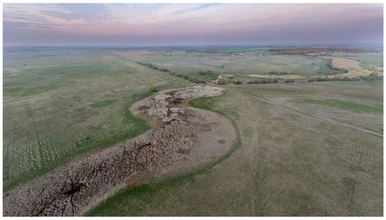
Figure 1.
An old, dried-up watercourse in autumn 2022 with some renewed vegetation after the September rains, showing the severity of the 2022 drought (photo by Gusztáv Jakab).
3. Geodynamic Setting
The Pannonian Basin (Figure 2), including our study area, the Tisza Plain, is considered to be a kind of “natural laboratory” because of its peculiar setting [8]. Indeed, the current hydrology, geomorphology and geology are the result of the interplay of many natural processes. The geodynamic history of the area is rather colorful. Apart from the mosaic of various tectonic settings, the Pannonian Basin is a patchwork concerning the uplift/subsidence pattern. There are zones with characteristic subsidence (e.g., Békés Basin); there are others which are uplifting (Bakony Hills, Visegrád Hills); and some other zones are quasi-neutral in this sense (e.g., the southern part of Transdanubia; cf. Figure 3).
The origins of this pattern go back to the Early Cenozoic to the Paratethys, a subbasin that was separated from the (neo)Tethys. During this time, the converging African plate consumed the space towards the Eurasian realm, and the disintegration of the Tethys and the presence of numerous microplates suffering CCW rotation during the northward motion (e.g., [9]) resulted in the separation of a large basin termed Paratethys. This separation is also reflected in the stratigraphy of the area (Paratethys stratigraphy), which differs from the worldwide-used stratigraphic system [10].

Figure 2.
Overview map of the Great Hungarian Plain (dotted line) within the Pannonian basin. The basin is surrounded by the Carpathian Mts. “K-puszta” is the location of the meteorological station, where the origin of the precipitation of the Great Hungarian Plain was analyzed in [11] (see Section 8).


Figure 3.
Uplifting (red arrows) and subsiding (blue arrows) parts of the Pannonian Basin, along a WNW–ESE axis, cf. Figure 2. Subsiding regions are characterized by nearly flat topography. The Great Hungarian Plain was filled up by riverine sediments in the last few million years, providing this extremely low relief.

The development of the area continued with the formation of the Pannonian Sea, later Pannonian Lake [12], a closed hydrological system similar in situation to the recent Caspian Sea. The geodynamic evolution continued in the form of orogeny in the surrounding PanCarDi (Pannonian–Carpathian–Dinaridic) region; the emerging of the Eastern Alps and the filling up of the Molasse Basin to the north redrew the direction of the main watercourses, creating the Paleo-Danube, which delivered large volumes of sediments towards the east. Contemporaneously, the rivers of the Western, Northern and partly of Eastern Carpathians delivered more material, which started to fill Pannonian Lake, which, at that time, trapped of all these sediments [10,13,14,15]. Various volcanic activities also contributed to development, creating volcanic edifices lying over the Pannonian (sedimentary) strata. These volcanic mountains, now hills, segment the otherwise floodplain-dominated Pannonian basin.
The filling up of the basin has continued until today; however, a basin inversion started ca. 5 million years ago, forming a puzzle of uplifting, subsiding and quasi-neutral areas. The evidence of subsidence is the thick pile of Neogene sediments in the Little Hungarian Plain (also termed Danube Basin or Győr Basin) in the NW and the Great Hungarian Plain (GHP) in the E and SE. Although, for the last 2–3 million years, the basin inversion has speeded up, the subsiding parts trapped the resulting thousands of km3 of siliciclastic material [10]. The eroded volume has been partly deposited in these subbasins and partly transported through the basin towards the Black Sea [12,16], maintaining a dynamic equilibrium within the Pannonian Basin.
In the (sub)recent phase of evolution during the Late Pleistocene and Holocene, the Paleo-Danube changed it course (previously flowing in the western part of the basin) [17], inheriting the channel of confluence of the Paleo-Vág (Váh), Paleo-Garam (Hron) and Paleo-Ipoly (Ipel’) rivers, breaking through the otherwise uplifting volcanic Börzsöny and Visegrád Hills. In the GHP, a similar reorganization of the rivers also took place, resulting in the formation of the Danube–Tisza Interfluve and the (present) Tisza Plain [18,19]. The subsidence of the subbasins is still typical, whereas the rivers, primarily the Tisza, reacted with fine changes, creating a large floodplain [20] which is partly inundated during the flood season of the year. Swamps and wetlands, as well as marshlands, characterize the mosaicked landscape, including various sizes of lakes. In historic times, Nagybecskerek Lake (in Nagybecskerek, today Zrenjanin, Serbia) existed for long and was one of the major steppe lakes in the area [21,22].
4. Low-Relief Land Use and Water Control Measures
River regulation and water control have been known since the Middle Ages in the GHP [23], even if these interventions are not comparable in volume to the large-scale operations of the 19th and 20th centuries. Throughout the entire historical period, the purpose and the way in which water was regulated depended, to a large extent, on the profile of agriculture. While livestock farming was the dominant sector, there was no need for significant water regulation, especially flood control, as flooding helped to irrigate pastures in a natural way. The earliest water engineering works were needed in response to changes in riverbeds and unforeseen increases in flood levels. Drainage and water control works are known from the 13th and 15th centuries in the GHP. The medieval water network was somewhat different from that shown on the map sheets of the First Military Survey of the 1780s. Written records mention several watercourses, later unknown, which were referred to as rivers and waterways [24]. These smaller watercourses were only reduced to small reaches in the 15th century. Since there were no active drainage works yet at that time, changes in land use (e.g., deforestation, increased soil erosion and siltation) might have caused this phenomenon.
In the context of the flourishing medieval fish farming on the floodplains of rivers, the prominent economic role of the floodplains is clear. By exploiting the natural geography of the floodplains, it was possible to create areas suitable for pond farming with relatively little investment, but a special, complex form of exploitation developed along with crop and livestock farming, termed “fok” management (hereafter referred to as fens farming). Floodplain farming was a multi-stage farming system in which each activity (livestock, crop production and various types of natural farming) required essentially the same activity (maintenance of the system of fens, dams, reservoirs and ditches) [25,26,27]. According to [25], this specific management type, fens farming, in the steppe was based on the “fok”, an artificial, man-made cut through the natural barrier immediately adjacent to the riverbed, so that during flooding the water could flow out into the floodplain of the valley and back into the riverbed when the flood was over (cf. also [28,29]).
The floodplains of lowland rivers in temperate continental areas are suitable for floodplain management, where the natural levees are breached or artificially cut, and favorable water conditions ensure periodic flooding. The maintenance of fens farming required keeping “fok” and channels clean, which meant the periodic removal of sediment and floating debris. Without this, the system became unusable, i.e., the ponds and channels became overgrown and swampy and finally silted up. This system began to disappear during the Ottoman occupation, as the population drastically declined; it became confined to the upstream reaches of the Tisza in the 16th century. The expansion of wetlands may also have been significantly influenced by the construction of fortifications at this time. The expansion of the Ecsed marsh (Ecsedi-láp), one of the largest wetlands in the GHP, may also have been significantly increased due to the water level artificially raised to protect the Ecsed fortress in the 14th century (Figure 4).
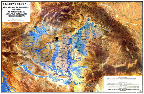
Figure 4.
The “pond map”, a well-known piece of Hungarian cartography from 1938. It shows a conceptual map of the permanent (dark blue) and temporary (light blue) water cover of the Hungarian lowlands prior to the water control measures (cf. e.g., [30]). Note that the permanently or temporarily water-covered regions (blue) correlate well in extent with the subsiding part of the GHP (cf. Figure 3).
Many refer to the map in Figure 4 as a kind of Romanesque vision of the ancient, original hydrological state of the Great Hungarian Plain. Although the map is declared to depict a “wild” state before the beginning of the water control works, which, according to the most common opinion, was due to the overgrown mills and the neglected network of fens, it shows a wetter and swampier picture than the medieval situation. The expansion of wetlands may have been influenced by the fortifications built during the Ottoman occupation. Historical ecological research suggests that from the 16th century to the mid-18th century, summers were persistently wet [31], which may have increased the extent of waterlogged areas. Compared with the situation suggested by the “swamp map”, we should certainly expect fewer swamps and marshes but more watercourses and lakes in the Middle Ages, but it would be speculative to draw a more accurate picture than this.
There is very little information on the vegetation of the Ecsed marsh, which was destroyed by drainage works before it could be scientifically studied. The still available data suggest that there may have been significant areas of floating reed islands in the marshland. After the Ottoman occupation, the importance of floodplain farming in the central Tisza region also declined, with grazing livestock remaining the dominant economic activity. Due to the lack of maintenance of the fens, many former fishponds silted up. According to Bellon [28], floodplain farming in this simplified form was well integrated into the food-producing system, and natural water fishing in particular flourished in some stretches of the Tisza even at the turn of the 18th and 19th centuries. Water mills, which proliferated in the early modern period, certainly played a role in the changes that happened to the floodplain. The valleys above the dams became waterlogged, and the lakes and ponds silted up and became swampy [23].
Perhaps, the most important message of this history is that the water-retention capacity of the landscape is largely a function of the soil (mainly peaty soils) and to a lesser extent a function of the vegetation; before the regulation works, the water-retention capacity of the entire flood-protected area exceeded the capacity of any artificial water storage.
5. Regulation of the Tisza River
After the Napoleonic Wars, during the period of economic development in the early 19th century, the deflooding and conversion to agricultural production of the 35–40,000 km2 of regularly or intermittently inundated lowland area became one of the most important political issues of the Hungarian state, which had partial autonomy within the Habsburg Empire. The main aim of regulation was to straighten the course of the main river, the Tisza, and to significantly narrow the wide floodplain, which was several kilometers wide and in some places tens of kilometers wide [32]. As a result of the work, the riverbed became steeper, and the water velocity increased in the regulated river sections [33]. Floods, especially spring snowmelt floods, accelerated, and the high-water levels rose to unprecedented levels, threatening previously apparently flood-free settlements [34,35]. Since regulation was initiated in the middle reaches, which were the politically and organizationally easiest areas, and it did not begin in the downstream sections proceeding towards the headwaters, the floods that thus accelerated in the lower reaches led to the famous flood disaster of the region and Hungary in 1879 [36] (cf. also [37]).
The aim of river regulation was basically threefold:
- To rearrange the developed meandering river network and to improve the discharge of floods by straightening the channel of the Tisza and partly that of its tributaries;
- To deflood and bring into agricultural production the 20,000 km2 of land by building a system of embankments along the river;
- To make the rivers navigable, which allowed the resulting surplus in agricultural products to be transported.
The technology for regulation was very simple. The meanders were cut by small trenches dug along the newly designed bed, which was usually widened by the flowing water to form a new bed. If this did not happen over a period of years, the ditch was artificially widened. On both sides of the new, straightened bed, clayey earth fillings about 4 m high were raised by handwork [34]. The distance between the fillings and the bed was a few hundred meters, with the typical width of the resulting floodplain being less than 1 km. This later proved to be insufficient from a hydraulic point of view and was in any case less than the width proposed by [32] based on experiences in Italy. From a geomorphological point of view, it is interesting that no attempt was made to place the levees on the first terrace level that accompanies the river in most places. The location of the levees was determined by property ownership and disputes with landowners and was usually closer to the river than optimal [36].
Of the three aforementioned objectives, the first was practically achieved before the First World War. The major part of the second objective was also achieved; here, the filling of the last flood-endangered sections was completed around 1930. Although navigability was partly achieved and to some extent used until the First World War, the new state borders and the division of the basin among Hungary, Romania, Czechoslovakia and the South Slavic state around 1920 minimized this. The Paris Peace Treaties dealt in detail with navigation rights on the Danube but did not apply to the Tisza, the largest tributary in the region. After the Second World War, the lack of a shipping fleet meant that shipping virtually ceased to exist, and rail transport, which had dominated until then, became the almost exclusive mode. The other two objectives were practically fully achieved; despite the periodic threats of exceptionally high floods, which were relatively rare, the old floodplain, including the historic wetlands, became protected from floods, but they are now agricultural areas. In the 20th century, partly due to natural market processes and the former land tenure structure, and later, under the communist regime, due to state and collectivized farming, farming became and is still almost entirely industrialized, large-scale farming.
6. The Consequences of River Regulation
The most obvious effects of river regulation and drainage have been those on land use and vegetation. It has been estimated that prior to regulation, up to two-thirds of the area of the GHP was covered by water during floods. Even in a basically continental climate, regular flooding allowed for the development of forest vegetation. Model calculations conclude that the soil and climatic conditions would allow for the establishment of forest vegetation, at least in the form of forest steppe, on 77% of the GHP. In contrast, it has been estimated that 37% of the area of the GHP was covered by forests [38]. As a result of thousands of years of deforestation and drainage, the total area of forests has now shrunk to only 1% [38]. Before water regulation, the felled floodplain forests were replaced by swamps and floodplain meadows. The total extent of all floodplain meadows and ancient marshes and swamps in the plain was about 44%. By 1960, this had shrunk to 3–6% [39] (Figure 5).
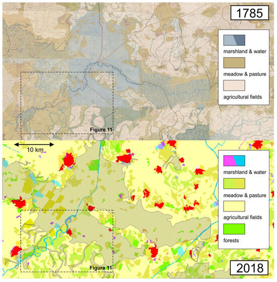
Figure 5.
Land cover changes in the Sárrét (translation: muddy meadow) region, a large swamp at the center of the Great Hungarian Plain prior to the water control measures. The 1785 situation is shown in a map sheet mosaic of the First Military Survey of the Habsburg Empire (top panel; cf. [40]), while the modern data are from the CORINE Land Cover 2018 dataset (bottom panel; [41]). Note that the former swamplands (cross-hatched area in the 2018 map) were almost totally turned into agricultural fields, while the original land use of a higher proportion of meadows and pastures has been maintained. For the location of the area, check Figure 2.
From a water management point of view, this system is radically different from its former natural or near-natural state. The annual flooding levels did not reach the former floodplains [42,43]. The evaporation of the croplands was, therefore, reduced to a fraction of what it had been, and even the contemporaneous renowned engineers of this period involved in planning pointed out that unless a network of irrigation canals and irrigation systems was built to somewhat model the old system, the area would dry out in the long term and become less and less suitable for agricultural production [44]. In addition to water management, the balance of sediment transport and deposition in the region has also changed [45]. The natural recharge of the plain has been halted by the inability of floods, especially in their initial stages, and especially of waters with high sediment loads to reach areas far from the rivers. Consequently, sedimentation no longer compensates for natural subsidence. This has the added significance that induced compaction due to drinking water and hydrocarbon extraction increases the rate of subsidence [46]. In the last ca. 150 years, this has not yet had many practical consequences, although inland excess water is slowly becoming more frequent in areas of faster subsidence.
The present water network in the flood-protected areas of the GHP mainly consists of irrigation and drainage canals. The course of these channels has often preserved the original watercourse traces because they formed by deepening the ancient channels (e.g., Kórógy, Veker-ér and Száraz-ér). However, the watercourses of the lowlands before water regulation differed fundamentally in their structure, function and effects from those of today. They were extremely wide (30–100 m) and shallow (1–1.5 m) and had no definite course. They could flow in opposite directions depending on local precipitation conditions or the water levels of the associated rivers [47]. These lowland watercourses were navigable, albeit intermittently, by rafts in the Middle Ages and were involved in inland transport of goods (e.g., salt). The shallow, slow-flowing water recharged the water levels and contributed to the rising of the groundwater levels. The channels formed in their place are narrow (5–10 m) and deep (2–3 m) and have a definite course. The channels cut deep into the ground drain surface water during periods of rainfall and groundwater during periods of drought.
From a regional hydrological perspective, however, perhaps the most important consequence is the drastic reduction in the landscape’s capacity to retain water. Ecosystems with high water-retention capacity have disappeared, and as we will see in the next section, large-scale agriculture has seriously affected soil structure, significantly reducing its water-holding capacity.
7. Changes in Soil Structure Due to Industrialized Agriculture
The typical soil sequence of the central part of the GHP is as follows: The dominant soil of the upper level is chernozem. In the river floodplains and lower areas, fluvisols are typical: meadow soil, histosol and peat soil (cf. [48], p. 97). Between the above two levels, there is saline (solonetz) soil, as seasonal fluctuations in groundwater accumulate salts here. The flood-free levels were already used for arable farming before river regulation. In most of the temporarily waterlogged areas, meadow soil was used for agriculture after the water control works. Here, the loss of water effect results in the formation of meadow chernozem, and in lower areas, the accumulation of salts leads to the formation of secondary solonetz. There are also extensive areas of sandy soil on the somewhat elevated former alluvial fan remnants.
As a result of river regulation, large areas of arable land, totaling tens of thousands of square kilometers, have been created. Some of these areas were formerly regularly or intermittently watered meadows and pastures, but following regulation, extensive wetland drainage has also occurred. Most of these have also become arable farmland.
In the 20th century, the role of smallholdings was subordinate. In the first half of the 20th century, in addition to concentrated land ownership, a small part of the arable land was farmed manually and on small plots, but mechanized farming appeared at the end of the 19th century and gained momentum in the 1930s. After WW II, the main aim of the agricultural policy of the communist political regime was collectivization and the introduction of large-scale, intensive board agriculture with mechanized farming. As a result, most of the arable land has been ploughed and harvested by machine since the 1950s and 1960s. The size of the small plots of land cultivated individually was negligible by comparison. Although the proportion of land owned by individuals began to rise again after the fall of communism, the landscape is still characterized by large-scale farming, with small plots in places.
It is not the large plots that cause these problems; it is regular machine cultivation that is causing a major change in soil structure. Repeated compaction by heavy machinery and deep ploughing result in a compacted soil layer at the bottom of the plough line [49,50]. Arable farming inherently inhibits rainfall infiltration. The primary reason for this is the crusting of the soil, which inhibits infiltration. As a result, the water-storage capacity of a ploughed soil is decreased, resulting in significantly lower available water supply [51]. Indeed, a series of comparative rainfall simulator experiments over the whole growing season [52] provide evidence that ploughing results in inhibited soil precipitation uptake for all soil conditions. The long-term effect of ploughing, which is known as plough pan [53] reduces the permeability of the compacted soil to infiltrating water.
The bulk density of chernozem and meadow chernozem soil is 0.9–1.4 g/cm3, depending on the tillage status. The typical ploughing depth in Hungary is 25–27 cm [54]. The resulting plough pan thickness is 5–15 cm, and its bulk density is cca. 1.8 g/cm3, resulting in reduced water permeability. This layer stores significantly less water than in its previous, uncompacted state [55,56]. This significantly reduces the amount of precipitation water that can be stored in the soil [57,58,59]. Deep infiltration of infiltrated water is inhibited by the plough pan; indirect evidence of this can be found in [60], where it is shown that low-molecular-weight humic matter in soil moves mostly parallel to the surface in the uppermost layer of topsoil, indicating a strong limitation on deep infiltration. As a result of the plough pan, originally good topsoil becomes similar to solonetz soil with a shallow impermeable layer [48]. Some 5–10 years after abandonment of cultivation, soil fauna and vegetation remove this pan [60]. This time can be reduced by using crops sown specifically for this purpose (e.g., oil radish; Figure 6).
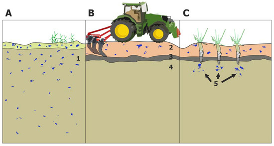
Figure 6.
Changes in the soil structure. (A) Original state after temporary inundation, (B) current structure (heavy machine ploughing) and (C) proposed solution using special plants (e.g., oil radish (Raphanus sativus var. oleiferus)) that can penetrate the impermeable layer. (1) Original soil structure, with appropriate soil moisture distribution. (2) Topmost cultivated layer. (3) The plough pan, a less permeable layer due to heavy-load machines. (4) Dry layer below the less permeable layer. (5) Partly saturated soil owing to plants penetrating the impermeable layer. This solution is only suitable for breaking through the secondary impermeable layer; it is not an immediate solution to restore the soil structure.
However, a little amount of precipitation water remains above this compacted layer, and the soil dries out rapidly even under average summer weather conditions. During periods of severe precipitation deficit or during periods of drought such as in 2022, there is virtually no groundwater above the compacted soil layer. This results in the complete destruction of crops that rely on water stored in the pores of the topsoil layer under such conditions, as happened in eastern Hungary in 2022.
8. Drought of 2022 in Eastern Hungary
In the summer of 2022, a severe drought hit several regions of Europe. The Iberian Peninsula, parts of France and northern Italy were the worst hit [61], but the local impact on crops was devastating in parts of Europe, including eastern Hungary. It is estimated that drought has so far caused between EUR 1.5 and 2.5 billion of damage to agriculture. In lowlands, maize yield losses were close to 100 percent. The area affected by drought damage declared to the compensation scheme exceeded 10,000 km² (Figure 7).
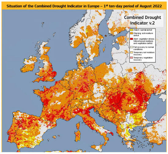
Figure 7.
Severity of the drought occurred in Europe in the extremely hot 2022 summer heat wave [1]. While the western and eastern parts of the continent were damaged by elongated anticyclonic periods, in the Great Hungarian Plain, the fronts occurred at almost normal rates, but they passed without precipitation.
To assess the components that contribute to precipitation in a normal year, we can use a proxy. An estimate of the water sources of precipitation in Hungary was made using isotope data from the station “K-puszta” (for its location, cf. Figure 2) installed in the central part of the country (and the area affected by the 2022 drought) over a one-year interval in 2012–2013. The results show that evaporation from the local area contributed 15% of the local precipitation; the Mediterranean area, 57%; and the Atlantic source, also 15%. Within this, the local sources mainly contributed to precipitation during spring snowmelt, as well as the convective events (thunderstorms) in June and August [11]. Compared with the multi-year average annual precipitation of 450–500 mm in the region, the value measured from September 2021 to August 2022 was around 250 mm [3], meaning that the 7 driest months of the last 90 years were recorded. A comparison of the 20-year average and the 2022 monthly data for a station in central Hungary is shown in Figure 8. Until the end of August 2022, the total rainfall in parts of the Great Hungarian Plain somewhat exceeded 100 mm this year. While the European drought of 2022 was caused by prolonged anticyclonic periods in the western part of the continent [62], Hungary also experienced a significant lag of the early summer precipitation maximum and thus a complete absence of local evaporation [2] (Figure 8 and Figure 9). There were two heat waves with record temperatures above 40 °C. In natural grasslands, the growing season was shortened to 1 month, and in many places, Quercus and Robinia forests became leafless unusually early.
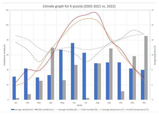
Figure 8.
Monthly averages of precipitation, temperature and relative humidity: twenty-year averages and data for the severely droughty year 2022 are shown separately for the station “K-puszta”, central Hungary (in a forest, not affected by urban influences). The measurement location is on the western edge of the severely drought-prone part of the GHP. Notable is the partial and almost complete absence of precipitation in June and July and the resulting drastic drop in humidity. The present work suggests that this drop is not only a consequence but also partly a cause: one of the conditions for the development of thunderstorms in summer is the humidity in the near-surface air layers, which was practically absent at that time. Data source: HungaroMet.
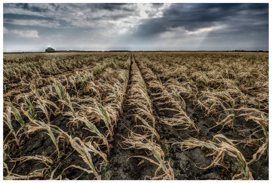
Figure 9.
A typical situation of summer 2022: there were clouds and medium-to-high levels of moisture in the atmosphere but no precipitation. The topsoil was completely dry, and the crops to be harvested in autumn had 100% yield loss in many places (26 July 2022; photo by Gusztáv Jakab).
We can describe the situation with a gross oversimplification: due to insufficient local evaporation, the thunderstorms that were otherwise the main source of summer precipitation were absent, and the cold fronts that closed the anticyclonic periods passed through without precipitation and with dry winds, further worsening the drought situation. Although the local source of precipitation is inferior to the vapor from the sea, it acts as an important trigger for thunderstorm formation; near-surface water saturation is a prerequisite for thunderstorm formation [63,64]. Soil with reduced water-holding capacity dries out to the point where the soil can no longer provide the near-ground moisture needed to support thunderstorms in the very early stages of drought. In the historical context, however, the drought of 2022 is not unprecedented but very rare [3,65,66,67].
9. Discussion: A Corrective Option and a Proposal
Eliminating the spatial structure that was created after river regulation is no longer an option. Any correction can only involve land use and cultivation changes affecting a small part of the area. This is proposed below.
The strategy has two phases:
- To increase the water-retention and water-storage capacity of the soil;
- To use the surplus water stored; in this way, the elongated transpiration of water by vegetation will provide sufficient near-soil moisture during summer.
The latter measure is necessary to allow the summer heat storms and frontal thunderstorms that do not occur with a completely dry ground layer to develop when other conditions (convective elements caused by natural warmth and wind shear at high altitudes due to the passage of fronts or local effects) occur. This would allow for the reintroduction into the water balance of the region of the mid-level marine (Mediterranean and Atlantic) sources of evaporation, the precipitation of which does not currently occur here in the absence of thunderstorms.
In the literature, the artificial enhancement of cloud cover and precipitation is referred to and discussed under the term of cloud seeding [68,69]. In our case, however, this term would be misleading. Our proposal does not aim at artificially accelerating cloud formation. The aim is to restore the natural cloud-seeding capacity that existed in the past and still exists today in the case of summers that are not very dry. In particular, during summer heatwaves, the aim is to trigger the formation of thunderstorms, which are the main source of precipitation during this period. The lack of thunderstorms is the main cause of droughts, but when they do occur, they help not only to irrigate but also to sustain the cloud and storm formation process itself by circulating water locally between the atmosphere and the ground (Figure 10).
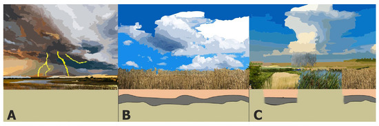
Figure 10.
The proposed concept is to recreate the conditions for summer thunderstorms even in years of low precipitation: the passage of summer cold fronts in the past and in humid years (A); today, in arid years (B); and as planned (C). (A) Natural state of the landscape with extensive floodplains and marshes: high evaporation causes fronts to pass through with thunderstorms, maintaining the landscape’s moisture. (B) The current state in drought years: no thunderstorms due to dryness of the near-surface air layers and persistent lack of rainfall. (C) The evaporation areas that we propose will replace some of the near-surface moisture, allowing thunderstorms to reappear in arid years, also bringing additional rainfall to agricultural areas.
The restoration of drained peatlands for water storage is of increasing importance worldwide, not only for hydrological reasons but also for nature conservation, tourism and agriculture [70,71,72,73,74]. Because of their significant water capacity, peat soils are highly suitable for groundwater storage, a function that has been fulfilled for thousands of years by the marshes associated with lowland rivers. The lowland plains of the GHP were once covered to a considerable extent by various types of peaty soils. These have suffered severe losses over the last century due to drainage, peat extraction and climate drying. Peatlands in the Hungarian part of the Great Hungarian Plain may have covered more than 29,000 ha, with an estimated peat volume of 205 million m3 [75]. The largest peatland basins were Ecsedi-láp and Kis-Sárrét, with peat reserves being estimated at 120 and 100 million m³ at the beginning of the 20th century. The extent of degradation is indicated by the fact that by the 1980s, there was nothing left of these peatlands [75,76]. Today, 96% of Hungary’s peat reserves are found in the hilly areas of the Transdanubian region, for example, in the swamps along the shores of Lake Balaton [76]. The example of Lake Tisza also shows that after artificial flooding, the formation of peatlands, floating reed islands and peaty soils can start in stagnant wetlands within a few decades.
The above set of proposals are not particularly novel in themselves; they are now considered standard elements of landscape reconstruction. In our case, however, the aim is to allow for the evaporation of the water stored in the soil in these areas by plant communities optimized for this purpose. This evaporation capacity is maintained for weeks to ensure that enough moisture is released into the near-surface air layers to enable frontal or convective thunderstorms to form.
To achieve this, a total area of around 5000 to 7000 km2 (about one-fifth of the total area covered by the scheme) will need to be restored to marsh vegetation or at least be converted to farming practices that restore and maintain soil water-holding capacity and ensure continuous summer evaporation. However, due to the ownership of the site, it is not envisaged that this area be contiguous but that it be restored to near-natural conditions in a mosaic (Figure 11). The work of Pinke et al. [29] was used as a guide for the proposed spatial extent and spatial proportions, and this is an obvious direction of future research.
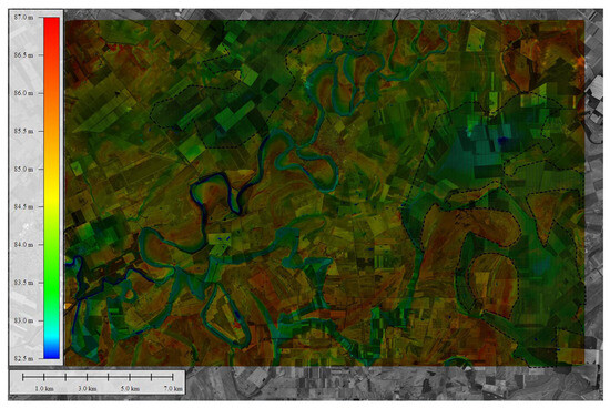
Figure 11.
Potential evaporation areas (dashed areas) on the northwestern edge of the Sárrét. The black and white satellite image shows that now, the whole area is under arable cultivation. The area has extremely low relief, and the color-coded elevation differences (strongly stretched to become visible) illustrate where it is possible to change the land use from crop fields to meadows or wetland to increase water retention and evaporation; the optimum locations for this are the bluish-green hue (lower elevation) areas. For the location of the area, check Figure 5.
The optimal areas for returning to near-natural conditions are:
- The lowest-lying areas in a given region (e.g., the administrative area of a municipality);
- The areas with the lowest production value (according to the Hungarian cadastral system, the lowest value of the “technical gold crown”) in the same area;
- The areas whose owners are willing to sell or lease them to the coordinating state agency;
- The areas whose size is greater than a minimum value (to be defined) or, if not, equal to the minimum value together with the neighboring or nearby areas which may be included in this system.
In the land included in the correction system, the secondary impermeable layer formed by large-scale agriculture should be broken at some points or broken by temporary planting vegetation capable of doing so.
The water supply of the near-natural landscape mosaic fragments to be created in the above ways and locations can be achieved using gravity-based channels and channels using old watercourses and reaches that can still be traced according to the topography, wherever possible. As snowmelt floods (Figure 12), or almost any type of flood, no longer occur every year in the main rivers in the area, water can only be supplied to these feeding watercourses by damming the rivers. For this purpose, in particular, the construction of an additional dam on the Tisza may be justified. Another option for efficient groundwater recharge that can also be considered is managed aquifer recharge (MAR; for applications in the region, see [77,78]).
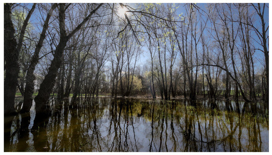
Figure 12.
Evapotranspiring vegetation can be found today almost only on the floodplains of rivers. Photo taken on 26 March 2023 during the spring flood on the floodplain of the Körös River: water cover and evapotranspiring vegetation (photo by Gusztáv Jakab).
10. Conclusions
Based on the long-term (historical) experience and especially on the lessons learned from the 2022 centennial drought, it is imperative that the conclusions of this study are followed up with various actions. In order to ensure that the parched Great Hungarian Plain receives more rainfall during the critical summer period and, parallel to that, that the water-retention capacity is restored, we propose to implement the following:
- Abandoning arable farming in areas that were regularly or intermittently inundated prior to the water control works.
- In these areas, political and financial regulators should designate landscape mosaic fragments where the primary objective is to increase soil water-retention capacity, autumn–winter–spring water storage and summer evaporation of stored water.
- The temporary planting of suitable vegetation (e.g., oil radish; Raphanus sativus var. oleiferus) should be used to reduce the secondary impermeable layer compacted through the use of heavy agricultural machinery. This should again increase the water-retention capacity of the upper part of the regolith (Figure 6).
- In the low-lying parts of the selected mosaic fragments, marsh vegetation should be used to promote local summer evaporation in the lower parts and meadow and pasture land use in the more elevated parts.
- These areas need to be supplied with additional water from rivers, typically in autumn and early spring or during possible extreme flood events. To achieve this, it is proposed to upgrade existing excess water drainage channels, reversing their flow direction. As the length of the high-water periods of the feeding rivers is much reduced, the construction of one dam on the Tisza and another on the Berettyó to partially return the water to its original course should be considered in addition to the existing dams.
The aim of all these measures is to ensure that during the critical summer months, at least parts of the currently driest central region of the Great Hungarian Plain will have water vapor in the lower atmosphere during summer. This is necessary to trigger thunderstorms associated with summer cold fronts in addition to heat showers in June, thereby increasing precipitation. In addition to the above strategic objectives, the transition also raises other issues of various nature, e.g., socio-economic, environmental, health, disaster management, etc., which are not addressed here. In addition, the scale of the intervention means that it must be preceded by a socio-professional debate. Without this, the necessary local social support or, ideally, identification cannot be hoped for. Nevertheless, intervention seems to be urgent.
11. Further Directions
In order to refine the concept outlined above and put it into practice, further research is needed in two main directions.
Firstly, it is necessary to clarify and quantify the water-storage capacity of the typical soils of the Great Hungarian Plain in their natural soil conditions before the formation of the plough pan. In other words, how much precipitation could be stored in soil layers at depths still available for summer evaporation? Likewise, it is necessary to quantify this water-storage capacity today, after the development of the plough pan. These questions have only indirect answers (mainly [58]).
There are no precise estimates yet (for the first estimates, see [29]) of the minimum and optimal extents of the area that should be devoted to water storage in the landscape and to permanent evaporation in summer. Also, an important question of this research is the minimum field size for land use change in mosaic design when designing alone and/or in clusters. The contribution to the triggering of summer storms should be tested on a smaller area first.
Last but not least, research should be carried out on the social impact of the proposed changes, on how the affected people would react and on how the necessary steps might be accepted.
Author Contributions
Conceptualization, G.T. and B.S.; methodology, G.T. and G.J.; validation, G.J.; formal analysis, G.T. and G.J.; investigation, G.T. and G.J.; data curation, G.T.; writing—original draft preparation, all; writing—review and editing, all; visualization, all; supervision, G.T. All authors have read and agreed to the published version of the manuscript.
Funding
The work of G.J. was supported by Climate Change Hungarian National Laboratory, RRF-2.3.1-21-2022-00014, under projects NKFIH 129167 and KKP 144209.
Data Availability Statement
Data is contained within the article.
Acknowledgments
The authors would like to thank the reviewers for their editorial and technical suggestions and comments. Róbert Mészáros and Zoltán Szalai (Institute of Geography and Earth Science, ELTE Eötvös Loránd University) were very helpful in obtaining meteorological and soil data.
Conflicts of Interest
The authors declare no conflicts of interest.
References
- Toreti, A.; Bavera, D.; Acosta Navarro, J.; Cammalleri, C.; de Jager, A.; Di Ciollo, C.; Hrast Essenfelder, A.; Maetens, W.; Magni, D.; Masante, D.; et al. Drought in Europe August 2022; Publications Office of the European Union: Luxembourg, 2022. [Google Scholar] [CrossRef]
- Horváth, Á.; Breuer, H. A víz körforgalma a légkörben és a 2022-es rendkívüli aszály meteorológiai háttere. Légkör 2023, 68, 2–8. [Google Scholar] [CrossRef]
- Szentes, O. Szárazság Magyarországon 2022-ben és a múltban. Légkör 2023, 68, 9–19. [Google Scholar] [CrossRef]
- Cholnoky, J. Az Alföld felszíne. Földrajzi Közlemények 1910, 38, 413–436. [Google Scholar]
- Lászlóffy, W. A Tisza-völgy. Vízügyi Közlemények 1932, 14, 108–142. [Google Scholar]
- Timár, G.; Rácz, T. The effects of neotectonic and hydrological processes on the flood hazard of the Tisza region (East Hungary). In Neotectonics and Seismicity of the Pannonian Basin and Surrounding Orogens—A Memoir on the Pannonian Basin; Cloetingh, S., Horváth, F., Bada, G., Lankreijer, A., Eds.; EGU Stephan Mueller Special Publication Series; European Geosciences Union: Göttingen, Germany, 2002; Volume 3, pp. 267–275. [Google Scholar]
- Vandenberghe, J. Timescales, climate and river development. Quat. Sci. Rev. 2005, 14, 631–638. [Google Scholar] [CrossRef]
- Cloetingh, S.; Maţenco, L.; Bada, G.; Dinu, C.; Mocanu, V. The evolution of the Carpathians–Pannonian system: Interaction between neotectonics, deep structure, polyphase orogeny and sedimentary basins in a source to sink natural laboratory. Tectonophysics 2005, 410, 1–14. [Google Scholar] [CrossRef]
- Piller, W.E.; Harzhauser, M.; Oleg Mandic, O. Miocene Central Paratethys stratigraphy–current status and future directions. Stratigraphy 2007, 4, 151–168. [Google Scholar] [CrossRef]
- Kuhlemann, J.; Frisch, W.; Székely, B.; Dunkl, I.; Kázmér, M. Post-collisional sediment budget history of the Alps: Tectonic versus climatic control. Int. J. Earth Sci. Geol. Rundsch. 2002, 91, 818–837. [Google Scholar] [CrossRef]
- Bottyán, E.; Czuppon, G.; Weidinger, T.; Haszpra, L.; Kármán, K. Moisture source diagnostics and isotope characteristics for precipitation in east Hungary: Implications for their relationship. Hydrol. Sci. J. 2017, 62, 2049–2060. [Google Scholar] [CrossRef]
- Kázmér, M. Birth, life and death of the Pannonian Lake. Palaeogeogr. Palaeoclimatol. Palaeoecol. 1990, 79, 171–188. [Google Scholar] [CrossRef]
- Uhrin, A.; Sztanó, O. Reconstruction of Pliocene fluvial channels feeding Lake Pannon (Gödöllő Hills, Hungary). Geol. Carpathica 2007, 58, 291–300. [Google Scholar]
- Uhrin, A.; Sztanó, O. Water-level changes and their effect on deepwater sand accumulation in a lacustrine system: A case study from the Late Miocene of western Pannonian Basin, Hungary. Int. J. Earth Sci. 2012, 101, 1427–1440. [Google Scholar] [CrossRef]
- Horváth, F.; Musitz, B.; Balázs, A.; Végh, A.; Uhrin, A.; Nádor, A.; Koroknai, B.; Pap, N.; Tóth, T.; Wórum, G. Evolution of the Pannonian basin and its geothermal resources. Geothermics 2015, 53, 328–352. [Google Scholar] [CrossRef]
- Kuhlemann, J. Post-collisional sediment budget of circum-Alpine basins (Central Europe). Mem. Sci. Geol. Padova 2000, 52, 1–91. [Google Scholar]
- Szádeczky-Kardoss, E. Geologie der rumpfungarländischen Kleinen Tiefebene. In Mitteilungen der Berg- und Hüttenmännischen Abteilung an der kgl. ung; Palatin-Joseph-Universität für Technische und Wirtschaftwissenschaften: Sopron, Hungary, 1938; Volume 10, pp. 1–442. [Google Scholar]
- Gábris, G.; Nádor, A. Long-term fluvial archives in Hungary: Response of the Danube and Tisza rivers to tectonic movements and climatic changes during the Quaternary: A review and new synthesis. Quat. Sci. Rev. 2007, 26, 2758–2782. [Google Scholar] [CrossRef]
- Thamó-Bozsó, E.; Murray, A.S.; Nádor, A.; Magyari, Á.; Babinszki, E. Investigation of river network evolution using luminescence dating and heavy mineral analysis of Late-Quaternary fluvial sands from the Great Hungarian Plain. Quat. Geochronol. 2007, 2, 168–173. [Google Scholar] [CrossRef]
- Timár, G.; Sümegi, P.; Horváth, F. Late Quaternary dynamics of the Tisza River: Evidence of climatic and tectonic controls. Tectonophysics 2005, 410, 97–110. [Google Scholar] [CrossRef]
- Székely, B. Rediscovering the old treasures of cartography—What an almost 500-year-old map can tell to a geoscientist. Acta Geod. Geophys. Hung. 2008, 44, 3–16. [Google Scholar] [CrossRef]
- Timár, G.; Székely, B.; Molnár, G.; Ferencz, C.; Kern, A.; Galambos, C.; Gercsák, G.; Zentai, L. Combination of historical maps and satellite images of the Banat region—Re-appearance of an old wetland area. Glob. Planet. Change 2008, 62, 29–38. [Google Scholar] [CrossRef]
- Károlyi, Z. A Tisza Mederváltozásai, Különös Tekintettel az Árvízvédelemre; VITUKI: Budapest, Hungary, 1960; 102p. [Google Scholar]
- Ortvay, T. Magyarország Régi Vízrajza a XIII-ik Század Végéig; Magyar Tudományos Akadémia Könyvkiadó-Hivatala: Budapest, Hungary, 1882; Volume 1, 544p. [Google Scholar]
- Andrásfalvy, B. A Duna Mente Népének Ártéri Gazdálkodása: Ártéri Gazdálkodás Tolna és Baranya Megyében az Ármentesítési Munkák Befejezése Előtt; Ekvilibrium: Budapest, Hungary, 2007; 440p. [Google Scholar]
- Bellon, T. Ártéri gazdálkodás az Alföldön az ármenetesítések előtt. In A Kárpát-Medence Történeti Földrajza; Frisnyák, S., Ed.; Magyar Tudományos Akadémia: Nyíregyháza, Hungary, 1996; pp. 311–321. [Google Scholar]
- Bellon, T. A Tisza Néprajza—Ártéri Gazdálkodás a Tiszai Alföldön; Timp Kiadó: Budapest, Hungary, 2003; 230p. [Google Scholar]
- Pinke, Z. Modernization and decline: An eco-historical perspective on regulation of the Tisza Valley, Hungary. J. Hist. Geogr. 2014, 45, 92–105. [Google Scholar] [CrossRef]
- Pinke, Z.; Kiss, M.; Lövei, G. Developing an integrated land use planning system on reclaimed wetlands of the Hungarian Plain using economic valuation of ecosystem services. Ecosyst. Serv. 2018, 30B, 299–308. [Google Scholar] [CrossRef]
- Babinszki, E. Térképek a múltból: A pocsolyatérkép. Élet és Tudomány 2017, 72, 911–913. [Google Scholar]
- Rácz, L. A Kárpát-medence éghajlattörténete a kora újkorban idején (1490–1800). A környezettörténeti források feldolgozásának módszerei. Történelmi Szle. 1995, 4, 487–508. [Google Scholar]
- Paleocapa, P. Parere Sulla Regolazione del Tibisco; Trattner-Károlyi: Pest, Hungary, 1846; 133p. [Google Scholar]
- Lászlóffy, W. A Tisza—Vízi Munkálatok és Vízgazdálkodás a Tiszai Vízrendszerben; Akadémiai Kiadó: Budapest, Hungary, 1982; 610p. [Google Scholar]
- Bogdánfy, Ö. A középtiszai nyílt árterek és gátszakadások hatása az árvíz magasságára. Vízügyi Közlemények 1916, 6, 163–170. [Google Scholar]
- Szlávik, L. Magyarország árvízvédelmének stratégiai kérdései. Vízügyi Közlemények 2000, 82, 553–594. [Google Scholar]
- Károlyi, Z. A szegedi árvíz, 1879. Vízügyi Történeti Füzetek 1969, 1, 1–80. [Google Scholar]
- Criss, R.E.; Shock, E.L. Flood enhancement through flood control. Geology 1998, 29, 875–878. [Google Scholar] [CrossRef]
- Bartha, D. Az Alföld jelenkori vegetációjának kialakulása. Hidrológiai Közlöny 1993, 73, 17–19. [Google Scholar]
- Mezősi, G. Magyarország Természetföldrajza; Akadémiai Kiadó: Budapest, Hungary, 2011; 393p. [Google Scholar]
- Timár, G. Possible Projection of the First Military Survey of the Habsburg Empire in Lower Austria and Hungary (Late 18th Century)—An Improvement in Fitting Historical Topographic Maps to Modern Cartographic Systems. ISPRS Int. J. Geo-Inf. 2023, 12, 220. [Google Scholar] [CrossRef]
- EEA SDI. CORINE Land Cover 2018 (Raster 100 m), Europe, 6-Yearly—Version 2020_20u1, May 2020. Available online: https://doi.org/10.2909/960998c1-1870-4e82-8051-6485205ebbac (accessed on 15 November 2023).
- Somogyi, S. Az ármentesítések és folyószabályozások (vázlatos) földrajzi hatásai hazánkban. Földrajzi Közlemények 1967, 91, 145–158. [Google Scholar]
- Schweitzer, F. A magyarországi folyószabályozások geomorfológiai vonatkozásai—Folyóink hullámterének fejlődése, kapcsolatuk az árvizekkel és az árvízvédelmi töltésekkel. Földrajzi Értesítő 2001, 50, 63–72. [Google Scholar]
- Kvassay, J. A Csekély Esésű Folyók Szabályozásának Alapelvei, Különös Tekintettel a Tiszára; Magyar Mérnök és Építész Egylet kiadása: Budapest, Hungary, 1889; 116p. [Google Scholar]
- Nagy, I.; Schweitzer, F.; Alföldy, L. A hullámtéri hordaléklerakódás (övzátony). Vízügyi Közlemények 2001, 83, 539–564. [Google Scholar]
- Joó, I. Recent vertical surface movements in the Carpathian Basin. Tectonophysics 1992, 202, 129–134. [Google Scholar] [CrossRef]
- Timár, G.; Gábris, G. Estimation of the water conducting capacity of the natural flood conducting channels of the Tisza floodplain, the Great Hungarian Plain. Geomorphology 2008, 98, 250–261. [Google Scholar] [CrossRef]
- Zech, W.; Schad, P.; Hintermaier-Erhard, G. Soils of the World; Springer: Berlin/Heidelberg, Germany, 2022; Volume 256, pp. 150–155. [Google Scholar]
- Pagliai, M.; Vignozzi, N.; Pellegrini, S. Soil structure and the effect of management practices. Soil Tillage Res. 2004, 79, 131–143. [Google Scholar] [CrossRef]
- Nawaz, M.F.; Bourrié, G.; Trolard, F. Soil compaction impact and modelling. A review. Agron. Sustain. Dev. 2013, 33, 291–303. [Google Scholar] [CrossRef]
- Jakab, G.; Németh, T.; Csepinszky, B.; Madarász, B.; Szalai, Z.; Kertész, Á. The influence of short term sealing and crusting on hydrology and erosion at Balaton Uplands, Hungary. Carpathian J. Earth Environ. Sci. 2013, 8, 147–155. [Google Scholar]
- Jakab, G.; Madarász, B.; Szabó, J.A.; Tóth, A.; Zacháry, D.; Szalai, Z.; Kertész, Á.; Dyson, J. Infiltration and soil loss changes during the growing season under ploughing and conservation tillage. Sustainability 2017, 9, 1726. [Google Scholar] [CrossRef]
- Morrison, C.G.T. The formation of pans in soil. Trans. Faraday Soc. 1922, 17, 321–324. [Google Scholar] [CrossRef]
- Huzsvai, L.; Rátonyi, T.; Nagy, J.; Megyes, A. A talajkímélő művelés hatása a talaj fizikai tulajdonságaira és a szervesanyag-körforgalmára. Acta Agrar. Debreceniensis 2003, 12, 42–45. [Google Scholar] [CrossRef] [PubMed]
- Dekemati, I.; Simon, B.; Vinogradov, S.; Birkás, M. The effects of various tillage treatments on soil physical properties, earthworm abundance and crop yield in Hungary. Soil Tillage Res. 2019, 194, 104334. [Google Scholar] [CrossRef]
- Liu, Z.; Cao, S.; Sun, Z.; Wang, H.; Qu, S.; Lei, N.; He, J.; Dong, Q. Tillage effects on soil properties and crop yield after land reclamation. Sci. Rep. 2021, 11, 4611. [Google Scholar] [CrossRef]
- Shaheb, M.R.; Venkatesh, R.; Shearer, S.A. A Review on the Effect of Soil Compaction and its Management for Sustainable Crop Production. J. Biosyst. Eng. 2021, 46, 417–439. [Google Scholar] [CrossRef]
- Shah, A.N.; Tanveer, M.; Shahzad, B.; Yang, G.; Fahad, S.; Ali, S.; Bukhari, M.A.; Tung, S.A.; Hafeez, A.; Souilyanonh, B. Soil compaction effects on soil health and crop productivity: An overview. Environ. Sci. Pollut. Res. 2017, 24, 10056–10067. [Google Scholar] [CrossRef] [PubMed]
- Islam, M.S. Cultivation and Drought Management in Agriculture: Climate Change Adaptation; Springer Nature: Cham, Switzerland, 2022; 217p. [Google Scholar] [CrossRef]
- Szalai, Z.; Szabó, J.; Kovács, J.; Mészáros, E.; Albert, G.; Centeri, C.; Szabó, B.; Madarász, B.; Zacháry, D.; Jakab, G. Redistribution of soil organic carbon triggered by erosion at field scale under subhumid climate, Hungary. Pedosphere 2016, 26, 652–665. [Google Scholar] [CrossRef]
- Tripathy, K.P.; Mishra, A.K. How Unusual Is the 2022 European Compound Drought and Heatwave Event? Geophys. Res. Lett. 2023, 10, e2023GL105453. [Google Scholar] [CrossRef]
- Faranda, D.; Pascale, S.; Bulut, B. Persistent anticyclonic conditions and climate change exacerbated the exceptional 2022 European-Mediterranean drought. Environ. Res. Lett. 2023, 18, 034030. [Google Scholar] [CrossRef]
- Oven, J. A study of thunderstorm formation along dry lines. J. Appl. Meteorol. Climatol. 1966, 5, 58–63. [Google Scholar] [CrossRef]
- Weckwerth, T.M. The effect of small-scale moisture variability on thunderstorm initiation. Mon. Weather. Rev. 2000, 128, 4017–4030. [Google Scholar] [CrossRef]
- Pinke, Z.; Decsi, B.; Kozma, Z.; Vári, Á.; Lövei, G. A spatially explicit analysis of wheat and maize yield sensitivity to changing groundwater levels in Hungary, 1961–2010. Sci. Total Environ. 2020, 715, 136555. [Google Scholar] [CrossRef]
- Czibolya, L.; Makra, L.; Pinke, Z.; Horvath, J.; Csepe, Z. Dependence of the Crop Yields of Maize, Wheat, Barley and Rye on Temperature and Precipitation in Hungary. Carpathian J. Earth Environ. Sci. 2020, 15, 359–368. [Google Scholar] [CrossRef]
- Erdődiné Molnár, Z.; Kovács, A.V. A 2022-es aszály agrometeorológiai elemzése. Légkör 2023, 1, 20–27. [Google Scholar] [CrossRef]
- Houghton, H.G. An Appraisal of Cloud Seeding as a Means of Increasing Precipitation. Bull. Am. Meteorol. Soc. 1951, 23, 39–46. [Google Scholar] [CrossRef][Green Version]
- Dennis, A.S. Weather Modification by Cloud Seeding; International Geophysics Series; Academic Press: New York, NY, USA; London, UK; Toronto, ON, Canada; Sydney, Australia; San Francisco, CA, USA, 1980; Volume 24, 267p. [Google Scholar]
- Cobb, A.R.; Dommain, R.; Tan, F.; Heng, N.H.E.; Harvey, C.F. Carbon storage capacity of tropical peatlands in natural and artificial drainage networks. Environ. Res. Lett. 2020, 15, 114009. [Google Scholar] [CrossRef]
- Liu, H.; Rezanezhad, F.; Lennartz, B. Impact of land management on available water capacity and water storage of peatlands. Geoderma 2022, 406, 115521. [Google Scholar] [CrossRef]
- Price, J.S.; Schlotzhauer, S.M. Importance of shrinkage and compression in determining water storage changes in peat: The case of a mined peatland. Hydrol. Process. 1999, 13, 2591–2601. [Google Scholar] [CrossRef]
- Stachowicz, M.; Manton, M.; Abramchuk, M.; Banaszuk, P.; Jarašius, L.; Kamocki, A.; Povilaitis, A.; Samerkhanova, A.; Schäfer, A.; Sendžikaité, J.; et al. To store or to drain—To lose or to gain? Rewetting drained peatlands as a measure for increasing water storage in the transboundary Neman River Basin. Sci. Total Environ. 2022, 829, 154560. [Google Scholar] [CrossRef] [PubMed]
- Valois, R.; Schaffer, N.; Figueroa, R.; Maldonado, A.; Yáñez, E.; Hevia, A.; Carrizo, G.Y.; MacDonell, S. Characterizing the water storage capacity and hydrological role of mountain peatlands in the arid Andes of north-central Chile. Water 2020, 12, 1071. [Google Scholar] [CrossRef]
- Dömsödi, J. Lápképződés, Lápmegsemmisülés: A Természet-és Gazdaságföldrajzi Változatok Szerepe a Tőzeglápok Hasznosításában; MTA Földrajztudományi Kutató Intézet: Budapest, Hungary, 1988; 120p. [Google Scholar]
- Dömsödi, J. Lápi eredetű Szervesanyag-Tartalékaink Mezőgazdasági Hasznosítása; Mezőgazdasági Kiadó: Budapest, Hungary, 1977; 125p. [Google Scholar]
- Czauner, B.; Erőss, A.; Szkolnikovics-Simon, S.; Markó, Á.; Baják, P.; Trásy-Havril, T.; Szijártó, M.; Szabó, Z.; Hegedűs-Csondor, K.; Mádl-Szőnyi, J. From basin-scale groundwater flow to integrated geofluid research in the hydrogeology research group of Eötvös Loránd University, Hungary. J. Hydrol. X 2022, 17, 100142. [Google Scholar] [CrossRef]
- Szabó, Z.; Szijártó, M.; Tóth, Á.; Mádl-Szőnyi, J. The Significance of Groundwater Table Inclination for Nature-Based Replenishment of Groundwater-Dependent Ecosystems by Managed Aquifer Recharge. Water 2023, 15, 1077. [Google Scholar] [CrossRef]


Disclaimer/Publisher’s Note: The statements, opinions and data contained in all publications are solely those of the individual author(s) and contributor(s) and not of MDPI and/or the editor(s). MDPI and/or the editor(s) disclaim responsibility for any injury to people or property resulting from any ideas, methods, instructions or products referred to in the content. |
© 2024 by the authors. Licensee MDPI, Basel, Switzerland. This article is an open access article distributed under the terms and conditions of the Creative Commons Attribution (CC BY) license (https://creativecommons.org/licenses/by/4.0/).