Abstract
Major function-oriented zoning, a key spatial planning strategy in China, aims to coordinate resource endowments, socio-economic development, and subsequent planning initiatives. However, the existing framework for major function-oriented zoning relies predominantly on socio-economic statistical indicators at the regional level, often neglecting the critical role of carrying capacity. To address this limitation, we assessed both the current state and dynamic trends of the carrying capacity to identify risk and advantageous zones for major functions, with the objective of optimizing major function-oriented zoning in the Yangtze River Delta region, China. Our findings indicate that 47 counties are experiencing significant pressure under the current carrying capacity, while 57 counties exhibit a deteriorating trend in their capacity. Over half of the counties are categorized as having an overloaded carrying capacity. Based on this analysis, 66 counties have been designated as risk zones for major functions. Consequently, the optimization of major function-oriented zoning requires adjustments in 10 counties, incorporating the identified risk and advantageous zones to enhance spatial planning efficacy. This study proposes an enhanced methodological framework for major function-oriented zoning by fully integrating carrying capacity assessments, offering substantial support for territorial spatial planning in China. We believe that these improvements contribute significantly to more resilient and sustainable regional development strategies.
1. Introduction
Spatial zoning, as a public tool to provide strategic guidance in regional coordinated development, has attracted global attention [1,2,3,4]. Western countries have transformed spatial zoning from material allocation to social development, which has placed emphasis on environmental factors [5]. In contrast, spatial zoning in developing countries remains in an exploratory phase. In China, major function-oriented zoning, a type of spatial zoning, has been implemented in a unique Chinese context over the last two decades. China is a vast country with the world’s largest population, characterized by significant regional heterogeneities in development status. Since the reform and opening, China has achieved rapid urbanization and industrialization, albeit at the cost of resources and environmental degradation. Meanwhile, there are disparities in economic development, resource endowments, and environmental carrying capacity across different regions in China [6]. In this context, China’s ongoing urbanization requires differentiated spatial zoning strategies to guide effective growth. Unlike China’s major function-oriented zoning, which is highly integrated into national economic and territorial strategies, countries like the USA and the European Union have developed spatial plans that are more decentralized and often emphasize regional coordination at state or regional levels. For instance, in the United States, spatial planning is heavily influenced by individual states and urban regions, with a focus on balancing development and environmental protection [7,8]. Similarly, the European Union’s spatial planning frameworks, such as the European Spatial Development Perspective (ESDP), aim to promote territorial cohesion and balanced regional development across member states [9]. These approaches, while sharing common goals with China’s zoning strategies, differ in terms of governance structure and implementation processes. Under such circumstances, it is significant to improve major function-oriented zoning to refine the existing knowledge of spatial zoning.
Although the goal of major function-oriented zoning to coordinate the relationships between economic development, ecological protection, and resource utilization is clear [10], identifying major functional zones is still a challenge for Chinese cities. On the one hand, a scale contradiction exists between zoning and representative indicators [11]. Generally, major function-oriented zoning is conducted at the county level, with indicators primarily based on county-level statistical data such as development intensity, Gross Domestic Product (GDP), and cultivated land quantity [12]. Consequently, spatially explicit indicators, such as land suitability and carrying capacity, are relatively underutilized. On the other hand, major function-oriented zoning is often determined according to the current situation of a certain region. The core idea of major function-oriented zoning integrates multiple factors, including natural conditions, socio-economic development, ecosystem characteristics, and human activities [13]. The indicators used to determine major function-oriented zoning are mainly selected at one fixed time-point, given data availability and applicability. Consequently, the concern of determining major function-oriented zoning is still urgent to be addressed.
Thus far, a large body of literature has been committed to conducting major function-oriented zoning. Fan, J., W. Sun, K. Zhou, and D. Chen [14] were the first to discuss the theoretical thinking and methodological framework of major function-oriented zoning according to the theories of regional function and spatial equilibrium. Also, the profile of China’s major function-oriented zoning was incorporated into the Nation’s 12th Five-Year Plan [15]. In addition, zoning schemes for Chinese regions and cities were successively proposed [11,16]. Recently, an increasing body of studies has focused on improving the methodological framework of major function-oriented zoning from the perspectives of eco-economic coordination [17], marine management [18], and coupling Sustainable Development Goals [19]. Despite the lack of consensus on the methodological framework, the core procedure to determine major function-oriented zones remains consistent and relies on a comprehensive evaluation of multiple indicators at a certain administrative unit. However, it should be noted that the original purpose of determining major function-oriented zoning is based on a region’s resource and environmental carrying capacity, development density, and potential [15]. Carrying capacity, however, was merely used as one of the indicators to identify major function-oriented zones. Therefore, further exploration is needed to develop a methodological framework for major function-oriented zoning that fully integrates carrying capacity.
Carrying capacity is often regarded as the ideal extent to which the earth can support a population, a concept frequently used in multiple disciplines [20,21,22]. Since rapid growth has resulted in ecosystem and environmental degradation during the last century, carrying capacity has become increasingly correlated with ecology [23], the environment [24], and natural resources [25]. The decreased carrying capacity worldwide has forced many countries to focus on carrying capacity for regional development [26,27,28], including spatial planning [29,30]. In China, carrying capacity has been confirmed to be closely related to economic growth, with land and water carrying capacities becoming the two critical factors restricting socio-economic development [27,31]. Thus, developing major function-oriented zoning based on carrying capacity has both practical necessity and theoretical significance.
In this study, we utilized carrying capacity to improve major function-oriented zoning of the Yangtze River Delta region. As one of China’s most economically dynamic areas, the Yangtze River Delta region plays a pivotal role in the nation’s modernization and comprehensive opening-up strategies. The central government has repeatedly emphasized the importance of supporting the integrated development of this region. However, due to traditional administrative boundaries in China, local governments within the region have independently designed their major function-oriented zoning strategies, leading to governance fragmentation. From a national strategic perspective, efforts have been made to dismantle these administrative barriers and implement productivity layouts based on regional major function-oriented zoning. Under these circumstances, this paper constructs a carrying capacity model that incorporates resources, environment, economy, and society. This model is used to optimize the major function-oriented zoning of the Yangtze River Delta, supporting the region’s sustainable development. The paper is structured as follows. The following section is a literature review on policy development of major function-oriented zoning and carrying capacity. Section 3 presents the framework. Section 4 introduces the study area, method, and data source. Section 5 and Section 6 cover the results and discussion, respectively.
2. Literature Review
2.1. Policy Development of the Major Function-Oriented Zoning
The policy of major function-oriented zoning was published by the State Council of China in 2010, aiming to achieve coordinated regional development through differentiated spatial regulations based on the territorial function [14]. Although no identical policy exists globally, similar regional planning concepts can be found in Western countries. For example, Germany’s regional policy emphasizes balanced development by categorizing major cities into zones with corresponding development plans, while England’s zoning classifies regions based on economic revival and growth potential [2,3]. In addition, in countries like the USA, spatial planning is more decentralized, with states and metropolitan areas responsible for their own development strategies, often guided by federal environmental and land-use regulations. The USA’s approach contrasts with China’s top-down governance, relying more on localized control and voluntary cooperation between regions [7]. Similarly, the European Union implements spatial planning at both the national and supranational levels, particularly through initiatives like the European Spatial Development Perspective (ESDP), which seeks to promote territorial balance and sustainable growth across the continent [9]. This decentralized, multi-level approach differs from China’s more centralized spatial governance model, where major function-oriented zoning plays a key role in integrating national, provincial, and local strategies.
Indeed, major function-oriented zoning can be dated back to the reform of spatial planning in the beginning of 21st century. In 2002, the preliminary principles of major function-oriented zoning in forging coordinated regional development to enhance the guidance of spatial planning was proposed. In the following years from 2003 to 2006, the ideals from functional zone to detailed function-oriented zone types were gradually determined in the process of formulating The Five-Year Plan for National Economy and Social Development. The introduction of the National Major Function-oriented Zoning Plan was a milestone; a framework with four zones, three types, and two levels was established [15,32]. Concretely speaking, the framework of the plan consisted of an optimized development zone, key development zone, restricted development zone, and prohibited development zone according to development intensity, urban development, agricultural production, and ecological protection, according to major functions [19], and the national/provincial level. The major function-oriented zones for China were delimited, which passed the stage examination in 2015. In that period, the primary goal of the major function-oriented zoning was providing support for spatial planning. In 2017, the enacted Opinions on Improving the System of Major Function-Oriented Zoning expanded its role in assessing government performance. It is stipulated that different performance assessment approaches should be implemented for different major function-oriented zones; ecology can be regarded as a type of product that local governments will be required to purchase through transfer payments.
Major function-oriented zoning, as an essential part of territorial spatial planning, was stipulated in the reform of spatial planning in 2019, highlighting its importance in spatial governance through two key approaches. First, the concept of major function-oriented zoning is integrated throughout the territorial spatial planning process. This integration requires refining the strategic framework of major function-oriented zonings to ensure the effective transmission and implementation of territorial spatial planning across all levels. Second, major function-oriented zones are defined at the county and even finer scales, to guide orderly local development through targeted spatial development polices.
2.2. Carrying Capacity
Carrying capacity was originally proposed to show the suitable numerical characteristics of living organisms that a certain place can support [20,33]. It emphasized that resource usage should be moderate to ensure the functions (e.g., self-regulation and self-recovery) of a place to sustain human development [34]. In the late 20th century, increasing pressure on resources and the environment from human activities shifted the focus of carrying capacity research from ecology to resource and environmental science. Related studies expanded to multiple dimensions, including resources, environment, ecology, and disasters [35,36,37]. With the widespread adoption of sustainable practices, the applicability of carrying capacity studies has been enhanced. More attention has been given not only to the dynamic changes in resource and environmental factors but also to the interactions between carrying capacity and human influences such as technological progress, social development, and policy responses [26,29,38,39,40].
In the Chinese context, the importance of coexistence between humans and nature has led to a series of practical policies related to carrying capacity, since the central government emphasizes ecological civilization and green development. The evaluation for a single and static carrying capacity no longer satisfies the need for practical management. The literature on carrying capacity is gradually shifting from classification, static, and qualitative to integration, dynamic, and quantitative evaluation [38,41,42]. Also, the concept of carrying capacity has evolved from carrying capacity for a single factor to comprehensive carrying capacity. Currently, the evaluation of carrying capacity with suitability for spatial development has become a basic means for formulating territorial spatial planning to balance resource development and protection.
2.3. Major Function-Oriented Zoning Based on Carrying Capacity
China’s major function-oriented zoning strategy emphasizes spatial development based on resource carrying capacity. This concept aims to align economic and population growth with specific geographic areas’ resource endowment and environmental capacity [10]. Carrying capacity is influenced by natural conditions and socio-economic factors, which vary across different regions [38,41]. To achieve coordinated regional development, it is crucial to ensure that the population size, economic scale, and industrial structure remain within the limits of local resource environmental carrying capacity. Accordingly, the indicator system for identifying major function-oriented zones incorporates key factors such as water and soil resource conditions, environmental capacity, and natural disaster risk, thereby guiding the adjustment of territorial spatial development patterns [37,38,42].
3. A Framework for the Major Function-Oriented Zoning Based on Carrying Capacity
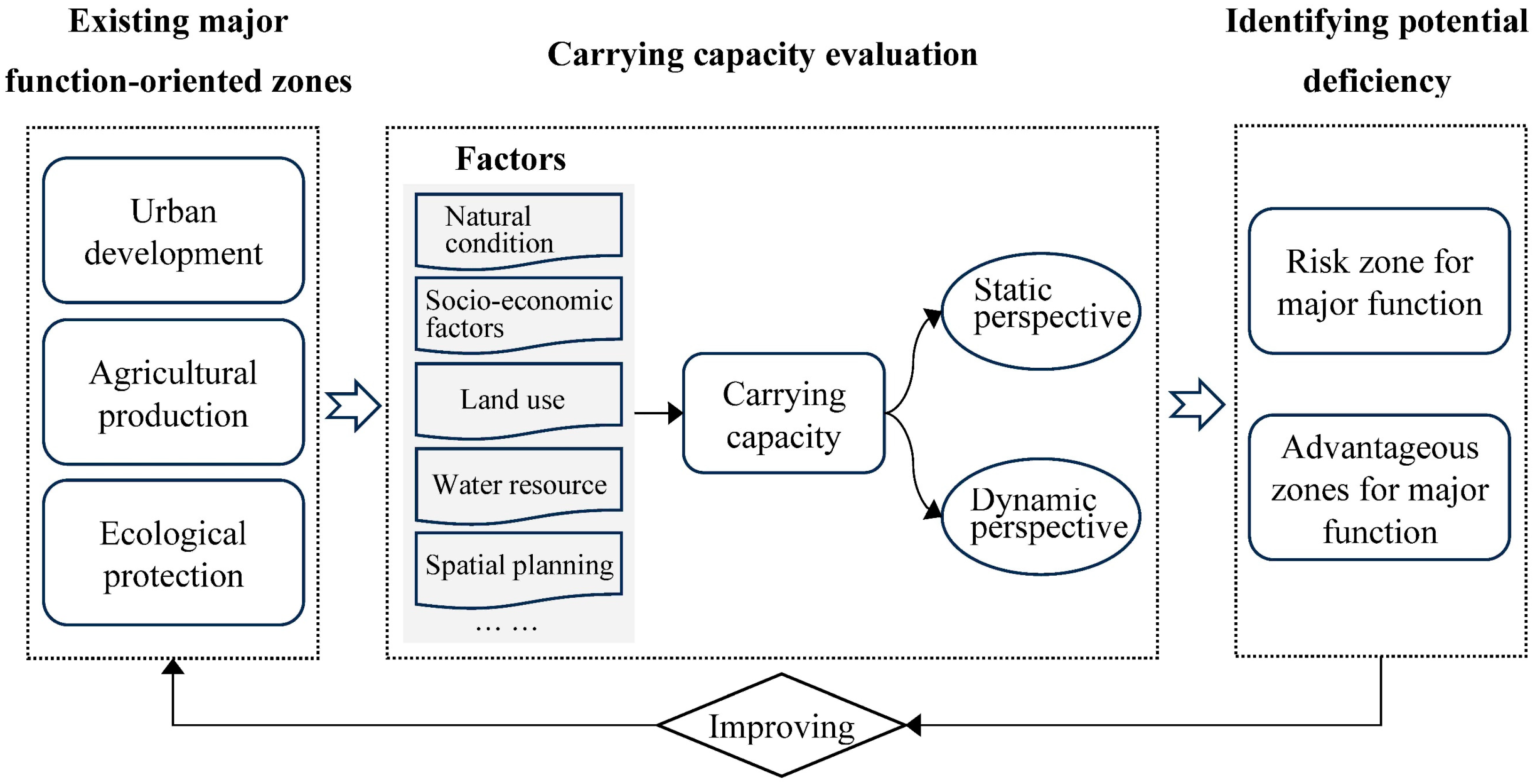
Major function-oriented zoning is a spatial governance tool aimed at managing resource allocation and achieving coordinated regional development. The optimization of major function-oriented zoning should address issues related to functional positioning and adjustment needs, which are closely associated with resource- and environment-based carrying capacity. It should be noted that carrying capacity is the indicator that shows the resource and environmental situation, providing the basis for major function-oriented zoning. Identifying the current state of carrying capacity provides the upper limits and bottom lines for determining the major function-oriented zones. Additionally, the future development of major function-oriented zones can also be considered, by accounting for the dynamic changes in carrying capacity over the past decades. Thus, the framework to develop major function-oriented zoning based on the current state and changing trends of carrying capacity is established (Figure 1).
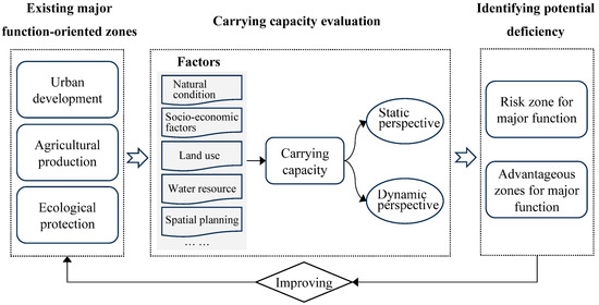
Figure 1.
Framework of improving major function-oriented zoning based on carrying capacity.
Thus, the first step of the improved framework for major function-oriented zoning is carrying capacity evaluation. The core concept of carrying capacity includes two aspects: the first is understanding the current state of regional resources and environmental endowments, and the second is comprehending the dynamic changes of regional resources and the environment to identify spatial development conflicts and opportunities. These aspects align with the dynamic optimization needs of major function-oriented zoning. To maximize the benefits of limited land resources, a carrying capacity evaluation, which combines natural conditions, socio-economic factors, land use, etc., with both static and dynamic perspectives, is necessary.
The second step of this framework is identifying potential deficiencies of the existing major function-oriented zoning, which involves analyzing risk zones and advantageous zones for major functions based on carrying capacity evaluation. Here, risk zones and advantageous zones for major functions are regions with developmental conflicts or opportunities for the existing major function-oriented zones. Based on the carrying capacity evaluation, the characteristics of resource and environmental backgrounds and their limitations or strengths can be identified to provide support for the baselines of spatial planning. By comparing the results of carrying capacity evaluation with the current development conditions, potential risks and specific strengths in regional development can be highlighted. This approach provides spatial strategies for high-quality development and helps coordinate prominent spatial conflicts between development and protection.
The third step involves improving the existing major function-oriented zones based on the identified risk zones and advantageous zones for major functions. Human–environment interactions lead the major function-oriented zones to change over time. The precise and flexible monitoring of the major function-oriented zones based on carrying capacity supports rational spatial governance as these dynamics evolve. Therefore, integrating the identified risk zones and advantageous zones for major functions enables the ongoing adjustment of the existing major function-oriented zones.
4. Study Area, Method, and Data Source
4.1. Study Area
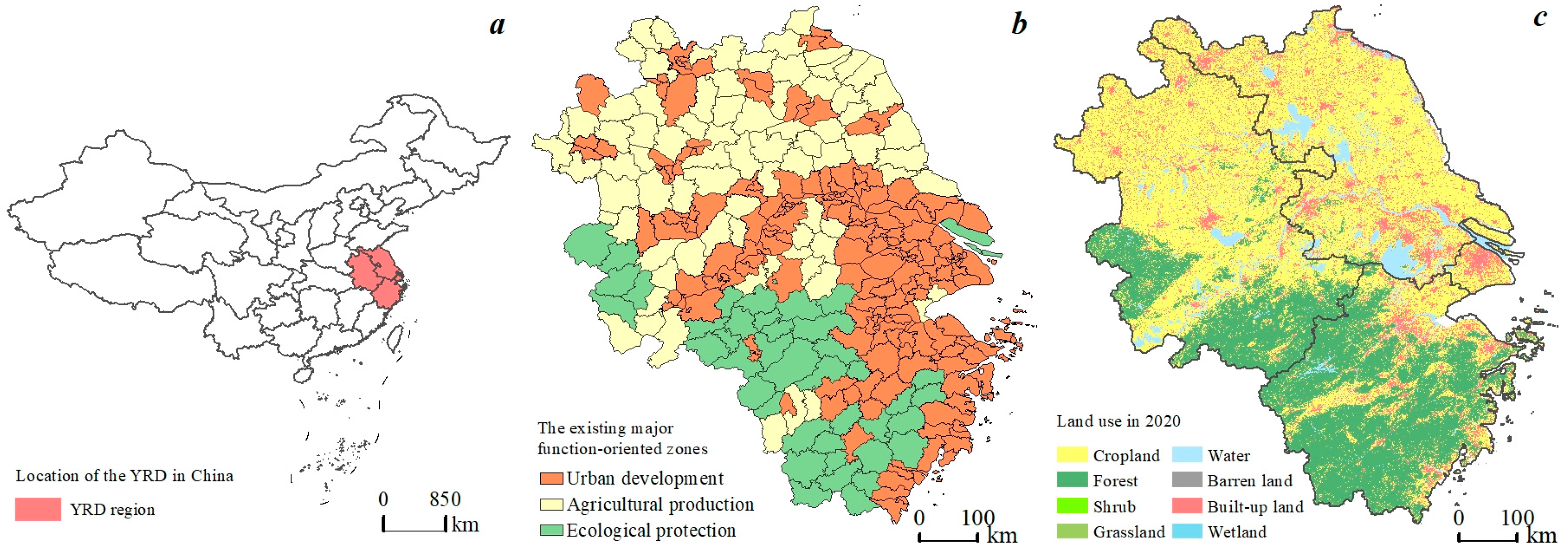
The Yangtze River Delta region is located along the eastern coast of mainland China, encompassing the Yangtze River Delta plain and the Hangzhou Bay coastal plain. Geographically, it lies within the third tier of China’s topography, featuring higher terrain in the south and west and lower elevations in the north and east. The region spans the subtropical and warm temperate monsoon climate zones, with an annual average precipitation of over 1000 mm, creating favorable conditions for human activities. The Yangtze River Delta is one of China’s most economically dynamic, open, and innovative regions, holding a significant strategic role in the nation’s modernization and comprehensive opening-up initiatives. With a high population density and a developed economy, it serves as the leading area of the Yangtze River Economic Belt and a major development cluster in China. This study focuses on the planning scope of the ‘Yangtze River Delta Regional Integration Development Plan’, which includes Shanghai, Jiangsu Province, Zhejiang Province, and Anhui Province (Figure 2). These areas span 358,000 square kilometers, accounting for 4.23% of the national total and comprising 305 county-level units.
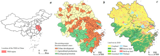
Figure 2.
Location of study area. (a) Location of the Yangtze River Delta Region in China. (b) The existing major function-oriented zones. (c) Land use in 2020.
Considering the differences in resource and environmental backgrounds and future development orientations across different regions, this study integrates the major functions of each county in the Yangtze River Delta region based on the spatial planning of major function-oriented zoning developed by provincial governments. The major functions include urbanized areas (national optimized development zones, provincial optimized development zones, national key development zones, provincial key development zones), major agricultural product production areas (national major agricultural product production areas, provincial major agricultural product production areas), and ecological function zones (national key ecological function zones, provincial key ecological function zones, and provincial ecological–economic zones). Major agricultural product production areas are mainly distributed in the northern region, urbanized areas are concentrated in the eastern region, and ecological function zones are primarily located in the southwest.
4.2. Research Methodology
4.2.1. Identifying Risk Zones for Major Functions Based on Carrying Capacity
We built a methodological process for identifying risk zones for major functions from the perspective of carrying capacity. This process includes evaluating spatial development suitability, analyzing the current state of carrying capacity, evaluating the dynamic trends of carrying capacity, and identifying risk zones for major functions.
- (1)
- Evaluating Spatial Development Suitability
Spatial development suitability was assessed to derive the current state of carrying capacity from the perspectives of the area and distribution. According to the existing literature [43,44,45], we evaluated spatial development suitability from the dimensions of natural conditions, land resources, water resources, and the geologic environment (Table 1). Furthermore, considering the policy contributions from the government, we took into account planning strategy, including ecological protection redline and permanent basic farmland. The factors are divided into four grades according to their constraints on spatial development: suitable, moderately suitable, less suitable, and unsuitable. The principle of limiting factors is applied, using the lowest score among the respective factors as the final score to determine spatial development suitability.

Table 1.
Indicators for evaluating spatial development suitability.
- (2)
- Analyzing the current situation of carrying capacity
Carrying capacity pressure indicates a matching degree between spatial development suitability and land development from the perspective of both area size and spatial distribution [19], reflecting the current situation of carrying capacity. Generally, when there is a larger number of suitable areas for spatial development and more developed land within suitable areas, the carrying capacity pressure is lower. Here, the model for evaluating carrying pressure was proposed as follows:
where is the current degree of development and is the current built-up land area. denotes the sum of suitable and moderately suitable areas for spatial development, representing the limits of the development scale. R is the matching degree of current built-up land area. and denote the area of current built-up land in suitable built-up areas and moderately suitable built-up areas, respectively. Due to the less suitable and unsuitable areas being negative for built-up areas, we consider that if the current built-up land is located in such areas, it represents a mismatch. and are the normalized values of the current development degree and distribution matching degree of region , respectively. is the pressure index of carrying capacity. A higher value of indicates greater pressure. The natural breaks method is utilized to classify the pressure of carrying capacity into low, medium, and high grades.
- (3)
- Evaluating dynamic trend of carrying capacity
To comprehensively reflect the dynamic changes in regional resources and the environment with socio-economic development, an evaluation for the dynamic trend of carrying capacity was conducted. Natural conditions and geological environmental factors for the evaluation of spatial development suitability do not change over time, which were excluded. Environmental factors are easily impacted by the socio-economic development factors that were included in this evaluation. Seven factors for the dynamic trend of carrying capacity evaluation were selected (Table 2). The values of each factor are standardized, and expert scoring is employed to determine the weights of each evaluation factor.
Table 2.
The factors to evaluate dynamic trend of carrying capacity.
The dynamic trend of carrying capacity was evaluated with the following formula:
where is the rate of change, which is classified into improving type (+) and deteriorating type (−) according to the regional average. is the base year 2009, and is the target year 2018. and are values of resource and environmental elements of the base year and target year, respectively. and are the Gross Domestic Product of the region in the base year and target year, respectively.
- (4)
- Identifying risk zones for major functions
We combined the current situation and dynamic trend of carrying capacity to determine the risk zones for major functions. The carrying capacity is graded by combining the results of the pressure and change of carrying capacity (Table 3). The carrying capacity was classified as overloading when the pressure was high and medium; otherwise, the carrying capacity was classified as loading. The dynamic trend of carrying capacity was used as a basis to determine the degree of overloading/loading status. Then, the region with an overloading carrying capacity was classified as a risk zone for major functions. The exception was that the critical overloading capacity with an improving type of carrying capacity in a medium pressure context was classified as no risk for major functions.
Table 3.
Relationships between carry capacity and risk zones for major functions.
4.2.2. Identifying Advantageous Zones for Major Functions
Based on the intrinsic characteristics of regional resources and the environment, an evaluation index system was constructed to identify regions with major function-oriented advantages (Table 4). Evaluations were conducted at the county level, with each indicator value classified into four grades: top 20%, 20–50%, 50–80%, and bottom 20%. For each function, the highest grade among the different indicators was used as the final result.
Table 4.
The indicators to identify advantage zones for major functions.
4.2.3. Improving Major Function-Oriented Zoning
We integrated the identified risk zones and advantageous zones for major functions to optimize the existing major function-oriented zones (Table 5). If the functional orientation rankings are consistent, decisions are made according to the principles of prioritizing food security and ecological environment, in the order of agriculture, ecology, and urbanization.
Table 5.
Judgment matrix to improve major function-oriented zoning.
4.3. Data Source
Multiple-sourced data were used in this study. The first type is a spatial dataset, including land use data, a Digital Elevation Model (DEM), geological environment maps, and planning maps. Land use data of the Yangtze River Delta region in 2009, 2013, and 2018 were obtained from the China National Land Survey and Planning Institute. The data were used to derive built-up land, ecological land, and cultivated land in a grid format with a 30 m resolution. DEM, with the resolution of 30 m, was downloaded from the Geospatial Data Cloud (https://www.gscloud.cn/, accessed on 1 March 2019), which was used to derive slope data and topographic relief. The geological environment maps including ground subsidence, active faults, mine lots, landslides, mudslides, and karst collapses, were collected from China National Land Survey and Planning Institute. Planning maps in 2018, including ecological protection redline and permanent basic farmland areas, were collected from the China National Land Survey and Planning Institute.
The other type is statistical data. The population, GDP, and grain output in 2009 and 2018 were extracted from official statistical yearbooks of municipal governments in the Yangtze River Delta region, including Shanghai, Jiangsu, Zhejiang, and Anhui. Water resource and water consumption data in 2009 and 2018 were obtained from the official water resource bulletins of the municipal governments. Environmental quality data, including PM10, SO2, and NO2, were obtained from the official environmental bulletins of the municipal governments. The existing major function-oriented zoning for each city was recorded from government websites of Bureau of Planning and Natural Resources in each respective city.
5. Results
5.1. Risk Zones for Major Functions
5.1.1. Spatial Development Suitability
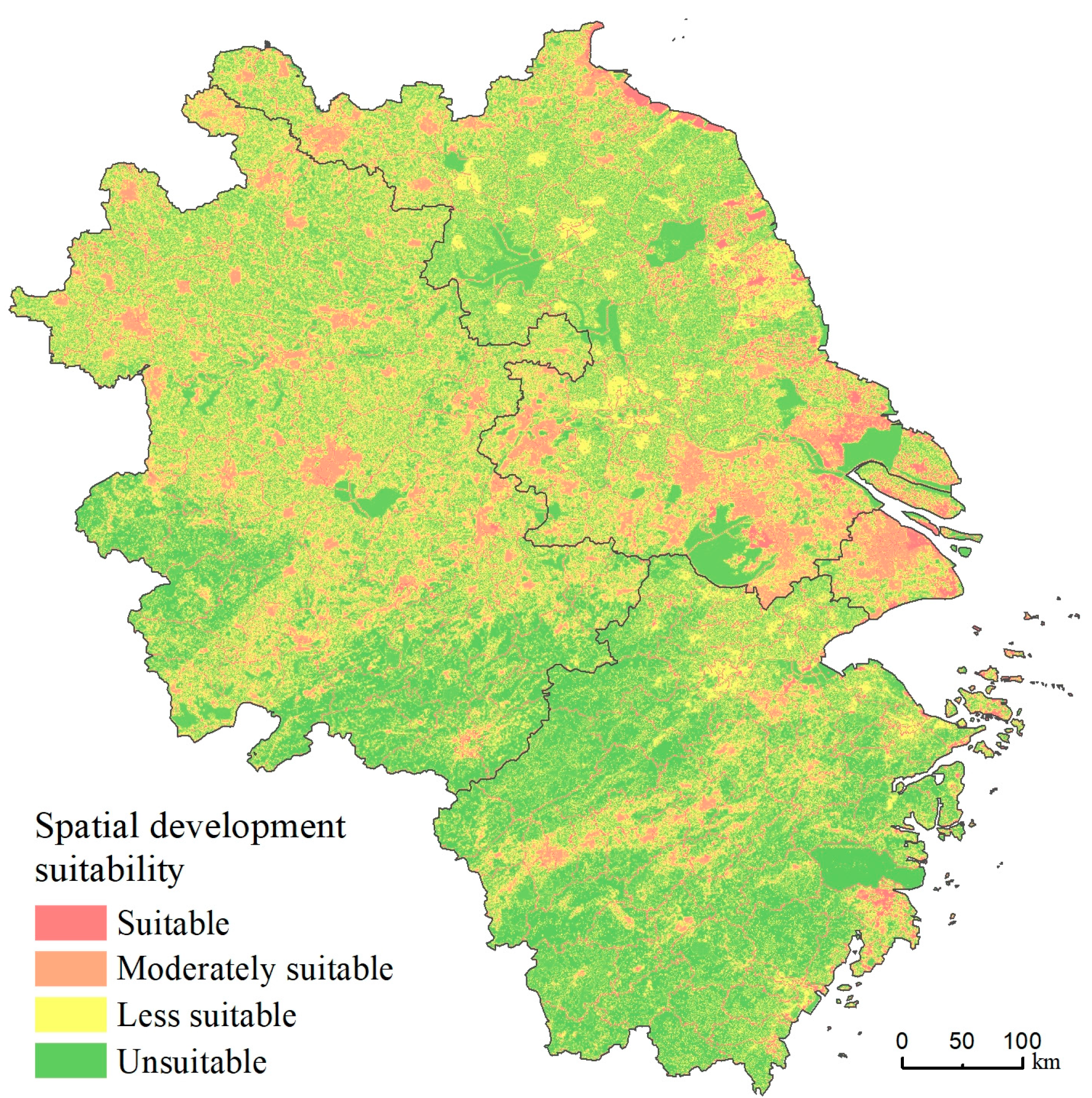
The Yangtze River Delta region has 47,198 km2 of suitable areas, accounting for 13.85% (Figure 3). These suitable areas are mainly distributed in the northern plain and eastern coastal areas, which are shown with dispersed patterns. Also, sectional suitable areas have scattered distributions in the flat terrain areas of the southwest. The moderately suitable area accounts for 51,819 km2 and 15.21% of the study area, with relatively more distributions in the eastern coastal and northern plain areas. The less suitable area is 90,531 km2, accounting for 26.58%, with 92.81% of its area in the mountainous and hilly areas in Zhejiang and Anhui. They are mainly limited by southwestern mountainous conditions, which are subjected to landslides and debris flows. Unsuitable areas accounts for 151,076 km2, taking the largest proportion of 44.35% in the study area. They are varied in their types. While unsuitable areas in Jiangsu and Anhui are mainly major lakes in ecological protection redline areas and farmlands in permanent basic farmland areas, those in Zhejiang are mountainous regions with ecological protection redline areas.
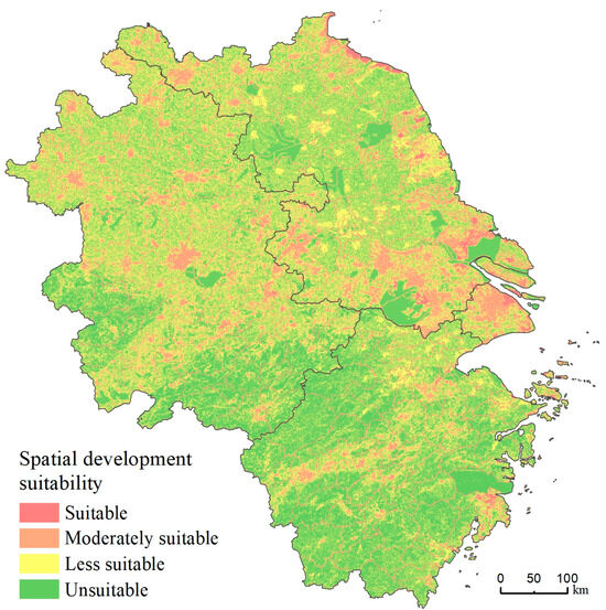
Figure 3.
The distribution of spatial development suitability in the Yangtze River Delta Region.
5.1.2. The Current Situation of Carrying Capacity
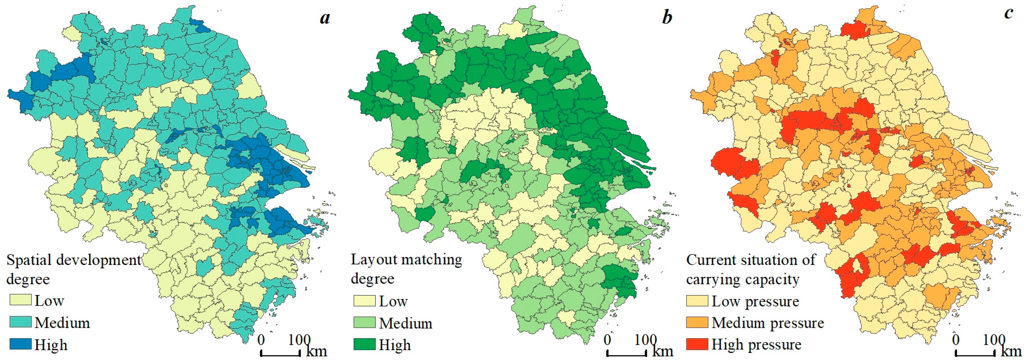
Regarding the spatial development degree, the counties in the Yangtze River Delta region range from 40% to 100% (Figure 4a). The results show that the counties with higher development degrees are mainly distributed in Shanghai, Jiangsu, northern Anhui, and eastern Zhejiang. There are 16 counties exceeding 90% in spatial development degree, primarily in highly concentrated central urban areas, where the intensity of land development is approaching saturation. Regarding the layout matching degree, the counties in the Yangtze River Delta region range from 60% to 100% (Figure 4b), which shows an overall good match between current built-up area and suitable built-up area. Areas with relatively lower matching degrees are mainly distributed in central and southern Anhui, as well as most of western Zhejiang.
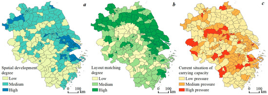
Figure 4.
The current situation of carrying capacity in the Yangtze River Delta. (a) Spatial development degree. (b) Layout matching degree. (c) The current situation of carrying capacity.
In terms of the current situation of carrying capacity, the pressure on carrying capacity in the Yangtze River Delta region is low (Figure 4c). A total of 148 counties and 110 counties are characterized by low and medium pressure on carrying capacity, respectively, accounting for 48.52% and 36.07%. Only forty-seven counties have high pressure on carrying capacity, accounting for 15.41%, including seven districts in Shanghai, twelve counties in Jiangsu, ten counties in Zhejiang, and eighteen counties in Anhui.
5.1.3. The Dynamic Trend of Carrying Capacity
In terms of the dynamic trend of carrying capacity (Figure 5a), most regions in the Yangtze River Delta show improving trends. There are fifty-seven counties with a deteriorating trend of carrying capacity, including eight counties in Jiangsu, fifteen counties in Zhejiang, and thirty-four counties in Anhui. These counties with a deteriorating trend of carrying capacity in Jiangsu (Liuhe District, Wuxi District, etc.) and Anhui (Hefei District, Wuhu District, Shitai County, etc.) are mainly characterized by low land use intensity and low environmental quality. However, those in Zhejiang (Changxing County, Quzhou District, etc.) are mainly characterized by low water resource usage efficiency.
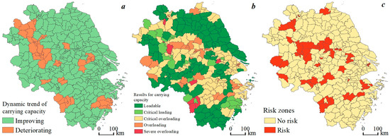
Figure 5.
The carrying capacity and identified risk zones for major functions. (a) Dynamic trend of carrying capacity. (b) The results for carrying capacity. (c) The risk zones identified.
5.1.4. The Identified Risk Zones for Major Functions
The results for carrying capacity (Figure 5b) show that the carrying capacity of 121 counties in the Yangtze River Delta region is adequate, which accounts for 39.67%. The carrying capacity of 27 counties is moderate. By contrast, the carrying capacity in more than half of the counties is overloaded. There are 110, 36, and 11 counties with critical overload, overload, and severe overload in carrying capacity, respectively, accounting for 36.07%, 11.80%, and 3.61%.
By combining the analysis of the current situation, dynamic trends, and the grades of carrying capacity, risk zones for major functions in the Yangtze River Delta region were identified (Figure 5c). There are sixty-six risk zones for major functions in the study area, including seven central urban districts in Shanghai, sixteen counties in Jiangsu, twelve counties in Zhejiang, and thirty-one counties in Anhui. The identified risk zones for major functions include 13 existing agricultural production zones, 10 ecological protection zones, and 43 urban development zones. The risk zones for major functions can be summarized into three types. The first is highly urbanized areas with limited land resource for future development, such as central urban districts of Shanghai, Wuxi, Nanjing, and Hefei. The second type is zones characterized by two major functions, where the relationships between urban development and agricultural production, urban development and ecological protection, or agricultural production and ecological protection do not coordinate, such as Donghai in Jiangsu, Dongyang, and Jiangshan in Zhejiang, and Woyang and Changfeng in Anhui. The third type is the zones where the spatial compatibility between resource usage and natural endowment are relatively poor, as seen in Huoshan and Jinzhai in Anhui Province.
5.2. Advantageous Zones for Major Functions
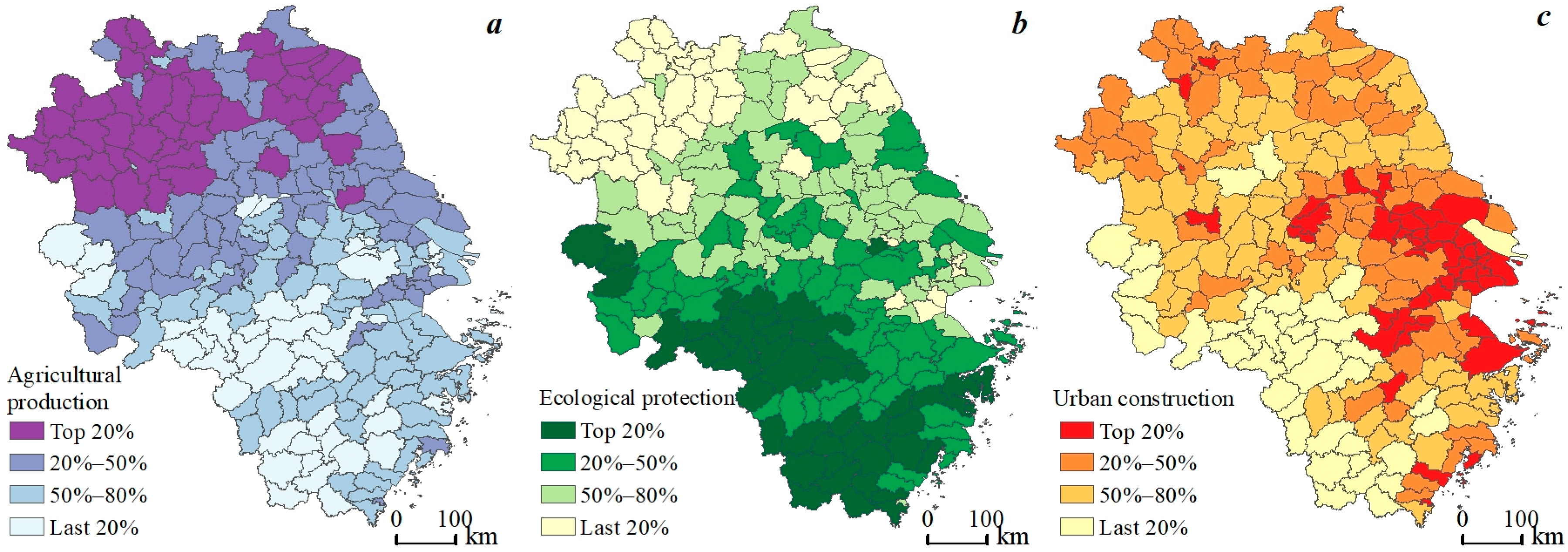
Advantageous zones for agricultural, ecological, and urban functions show distinct spatial patterns in the Yangtze River Delta Region. In terms of agricultural production function, advantageous zones are primarily concentrated in the north of the Yangtze River Delta, covering Jiangsu Province and Anhui Province (Figure 6a). In terms of ecological function, advantageous zones are mainly distributed in the south of the study area, including the southwestern portion of Anhui Province and most of Zhejiang Province (Figure 6b). Regarding advantageous zones for urban construction function, they are concentrated in the cities along the Yangtze River and the eastern coast (Figure 6c). Notably, the top 20% of ranked areas for each function are significantly segregated, facilitating a more precise determination of the dominant functions for each county.
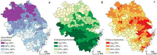
Figure 6.
Advantageous zones for major functions in the Yangtze River Delta Region. (a) Agricultural production. (b) Ecological protection. (c) Urban construction.
5.3. The Improved Major Function-Oriented Zoning
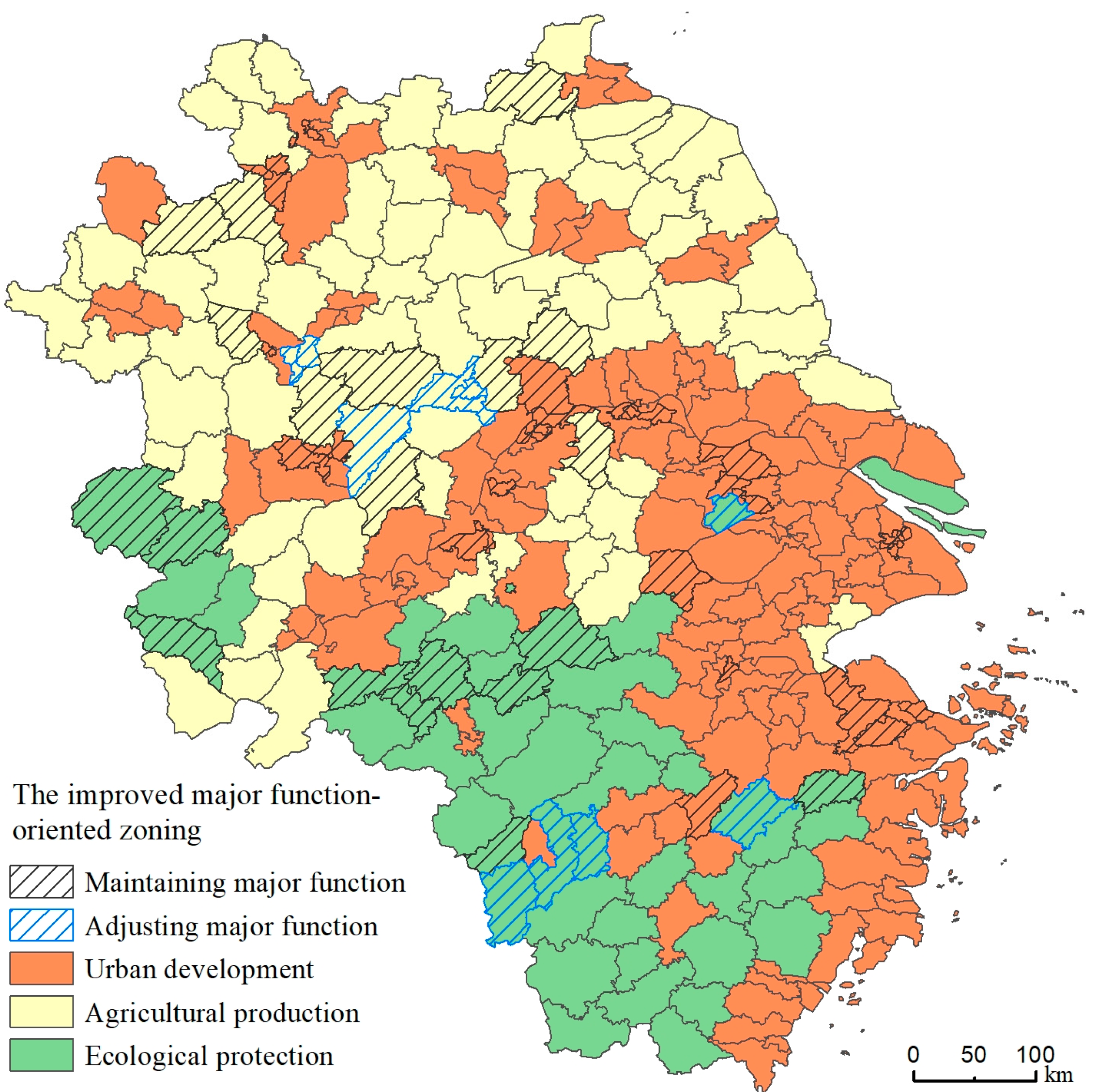
The improved major function-oriented zones in the Yangtze River Delta region are shown in Figure 7. Among the 66 identified risk zones for major function, 56 counties maintain their original functions, while the remaining 10 counties undergo functional adjustments. The results indicate the effectiveness of the original functional definitions concerning carrying capacity. Specifically, thirty-six counties maintain their original major function for urbanization risk zones, five are adjusted to major agricultural production zones, and two are reassigned as ecological functional zones. For agricultural production risk zones, ten counties retain their functions, while three are adjusted to ecological functional zones. All original ecological function risk areas maintain their functional positioning.

Figure 7.
The improved major function-oriented zoning.
Table 6 illustrates detailed transformation results. Compared with the original major function-oriented zones, the number of urbanized areas in the Yangtze River Delta decreases by seven (Binhu District in Jiangsu Province, Dongyang City in Zhejiang Province, Datong District, Feidong County, Langya District, Nanqiao District, and Tianjia’an District in Anhui Province). Major agricultural production areas increase by five (Datong District, Feidong County, Langya District, Nanqiao District, and Tianjia’an District in Anhui Province) and decrease by three (Jiangshan City, Longyou County, and Qujiang District in Zhejiang Province), resulting in a net increase of two. Ecological functional areas increase by five (Binhu District in Jiangsu Province, Dongyang City, Jiangshan City, Longyou County, and Qujiang District in Zhejiang Province).
Table 6.
The optimized suggestion for risk zones for major function.
Differentiated management and control strategies are proposed for regions that retain their original functional positioning based on specific carrying capacity pressure and depletion trends (Table 6). In areas with high development intensity, it is suggested to rationalize urban growth through land-use management based on the principle of resource conservation and efficient utilization. In regions where spatial development is mismatched with spatial development suitability, land development and utilization should be guided towards suitable areas to enhance the dominant functions.
6. Discussion
6.1. Comparison with Existing Major Function-Oriented Zone
Since the implementation of major function-oriented zoning in China, functional zones have been established as the foundational system for national spatial development and protection. In recent years, major function-oriented zoning has been widely conducted, relying heavily on the quantitative aspects of economic, social, environmental, and resource conditions at the scale of administrative regions. In other words, while traditional resource and environmental carrying capacity have gradually been emphasized in major function-oriented zoning, the relationships between them in the practical procedure remain unclear. Consequently, the specific patterns of resource and environmental conditions were often overlooked. Essentially, the settings of major functions for some administrative regions were based on statistics and current developmental situations, resulting in discrepancies between designated functions and changing endowments in recent years. Thus, the existing framework for conducting major function-oriented zoning may not meet future developmental and protection requirements, struggling to address emerging spatial governance challenges and providing insufficient support for achieving development goals.
This study has addressed these gaps. On one hand, the relationships between carrying capacity and major function-oriented zoning were established in the practical procedure. In the framework, carrying capacity as a foundational role to set major function-oriented zones is clarified. In the operationalization stage, the evaluation of carrying capacity is used to identify the risk zones for the major functions, which is beneficial to develop the existing major function-oriented zones. On the other hand, the evaluation of carrying capacity for setting the major function-oriented zones is deepened by coupling the current situation and change trend of carrying capacity. While the evaluation for the current situation of carrying capacity is helpful to identify the spatial pattern of resources and the environment within an administrative region, the evaluation for dynamic change of carrying capacity is committed to show the potential of future carrying capacity. Then, the comprehensive carrying capacity can be analyzed, which is used to identify the risk zones for major functions. This approach aims to optimize major function-oriented zoning, contributing to the establishment of a dynamic adjustment mechanism for the major function-oriented zone.
6.2. Policy Implication
The major function-oriented zone strategy is the strategic, basic, and binding system for China’s spatial planning. Over the years, major function-oriented zone systems have shown advantages in their strategic leading role at the national level. However, the system’s weak link lies in the top–bottom transmission of rigid control. To address this, establishing a binding relationship between national strategies and lower-level government spatial planning is crucial for effective implementation. At the policy level, governments should combine the implementation evaluation mechanism of land and space planning across all levels and ensure the effective assessment of the implementation of major function-oriented zones. Additionally, a dynamic adjustment mechanism should be established to update the list of major function-oriented zones based on resource and environmental carrying capacity and regional development shifts. Higher levels of government should implement differentiated performance appraisal policies according to the evaluation outcomes of the major function-oriented zones in subordinate administrative areas. Furthermore, governments at all levels should develop supportive policies related to bonus distribution and cadre promotion to encourage officials to align their actions with the major function-oriented zone strategy.
6.3. Limitations
This study still has two limitations to be addressed. The first is the inadequate cases for empirical analysis. It should be noted that the priority for the major function-oriented zoning may differ across regions. Our study prioritizes ecological protection and food security in the development suitability evaluation according to the situation of the Yangtze River Delta, while ecological protection redline areas, permanent basic farmland, and ecological/cultivated land were considered in the analyses for the carrying capacity and risk identification. However, the conditions should be differentiated in other regions where development may be the first goal. The second limitation is the incomplete process of evaluating carrying capacity for developing major function-oriented zoning, particularly in the aspect of the dynamic trends of carrying capacity. Since data unavailability limits the indicators for evaluating the dynamic trends of carrying capacity, only several aspects were included. In fact, including more indicators for the dynamic trends of carrying capacity would make the carrying capacity evaluation more precise if the data requirements can be met.
7. Conclusions
Major function-oriented zoning, as a crucial spatial planning strategy in China, is enacted to coordinate resource endowments, socio-economic development, and further planning efforts. However, major function-oriented zone planning relies heavily on socio-economic statistical indicators from a certain region. Relatively rare attempts have been made to use carrying capacity to design major function-oriented zoning from the perspectives of the current situation and dynamic trends. To crack the issue, we incorporated carrying capacity evaluation into the methodological framework of major function-oriented zoning. Firstly, carrying capacity was assessed according to spatial development suitability evaluation, which was used to identify the risk zones for major functions. Secondly, advantageous zones for major functions were identified by assessing the major functions of urban development, agricultural development, and ecological protection. Finally, major function-oriented zones were identified by considering risk zones and advantageous zones for major function. The Yangtze River Delta region in China was used as a case.
The results show that more than half of counties are identified with an. overloaded carrying capacity. Based on such findings, 66 counties are identified as risk zones for major functions. The optimization for the major function-oriented zones involves the adjustment of major functions in 10 counties to be considered risk zones and advantageous zones for major functions. Following the improved major function-oriented zoning, the zones designated for primary agricultural production and ecological functions have increased, echoing the priorities in ecological protection and food security in the Chinese context.
Author Contributions
Conceptualization, Q.Z.; writing—review and editing, Q.Z. and Y.C.; methodology, L.W.; writing—original draft preparation, L.W.; project administration, Q.Z. and H.W.; resources, C.T.; supervision, Y.S.; visualization, T.L. All authors have read and agreed to the published version of the manuscript.
Funding
This research received no external funding. And the Article Processing Charge (APC) was funded by the Shanghai Institute of Natural Resources Survey and Utilization.
Data Availability Statement
The original contributions presented in the study are included in the article, further inquiries can be directed to the corresponding author.
Acknowledgments
For the data support from “National Earth System Science Data Center. (https://www.geodata.cn) (accessed on 1 March 2019)”.
Conflicts of Interest
The authors declare no conflict of interest.
References
- Lloyd, M.G. British planning: 50 years of urban and regional policy. Land Use Policy 2000, 17, 359–360. [Google Scholar] [CrossRef]
- Trkulja, S.; TošiĆ, B.; Živanović, Z. Serbian spatial planning among styles of spatial planning in Europe. Eur. Plan. Stud. 2012, 20, 1729–1746. [Google Scholar] [CrossRef]
- Hirt, S. Form follows function? How America zones. Plan. Pract. Res. 2013, 28, 204–230. [Google Scholar] [CrossRef]
- Munroe, D.K.; Croissant, C.; York, A.M. Land use policy and landscape fragmentation in an urbanizing region: Assessing the impact of zoning. Appl. Geogr. 2005, 25, 121–141. [Google Scholar] [CrossRef]
- Zhao, Y.; Leng, H.; Sun, P.; Yuan, Q. A spatial zoning model of municipal administrative areas based on major function-oriented zones. Sustainability 2018, 10, 2976. [Google Scholar] [CrossRef]
- Ye, C.; Liu, Z. Rural-urban co-governance: Multi-scale practice. Sci. Bull. 2020, 65, 778–780. [Google Scholar] [CrossRef]
- Stead, D.; Meijers, E. Spatial Planning and Policy Integration: Concepts, Facilitators and Inhibitors. Plan. Theory Pract. 2009, 10, 317–332. [Google Scholar] [CrossRef]
- Kaiser, E.J.; Godschalk, D.R.; Chapin, F.S. Urban Land Use Planning; University of Illinois Press: Champaign, IL, USA, 1995. [Google Scholar]
- Faludi, A. The European Spatial Development Perspective (ESDP) and North-West Europe: Application and Implications. Built Environ. 2000, 26, 41–52. [Google Scholar]
- Nie, X.; Lu, B.; Chen, Z.; Yang, Y.; Chen, S.; Chen, Z.; Wang, H. Increase or decrease? Integrating the clumondo and invest models to assess the impact of the implementation of the major function oriented zone planning on carbon storage. Ecol. Indic. 2020, 118, 106708. [Google Scholar] [CrossRef]
- He, J.-L.; Zong, Y.-G.; Gebhardt, H. New spatial strategy in China: Major function zoning of Beijing-Tianjin metropolitan area with perspective from ecological economics. J. Urban Plan. Dev. 2011, 137, 484–494. [Google Scholar] [CrossRef]
- Bao, S.; Lu, L.; Zhi, J.; Li, J. An optimization strategy for provincial “production–living–ecological” spaces under the guidance of major function-oriented zoning in China. Sustainability 2024, 16, 2248. [Google Scholar] [CrossRef]
- Wang, Y.; Fan, J. Multi-scale analysis of the spatial structure of China’s major function zoning. J. Geogr. Sci. 2020, 30, 197–211. [Google Scholar] [CrossRef]
- Fan, J.; Sun, W.; Zhou, K.; Chen, D. Major function-oriented zone: New method of spatial regulation for reshaping regional development pattern in China. Chin. Geogr. Sci. 2012, 22, 196–209. [Google Scholar] [CrossRef]
- Fan, J.; Sun, W.; Yang, Z.; Fan, P.; Chen, D. Focusing on the major function-oriented zone: A new spatial planning approach and practice in China and its 12th five-year plan. Asia Pac. Viewp. 2012, 53, 86–96. [Google Scholar] [CrossRef]
- Yong, Y.; Zhang, H.; Wang, X.R.; Schubert, U. Urban landuse zoning based on ecological evaluation for large conurbations in less developed regions: Case study in Foshan, China. J. Urban Plan. Dev. 2010, 136, 116–121. [Google Scholar] [CrossRef]
- Zhang, Z.; Chang, T.; Qiao, X.; Yang, Y.; Guo, J.; Zhang, H. Eco-economic coordination analysis of the yellow river basin in China: Insights from major function-oriented zoning. Sustainability 2021, 13, 2715. [Google Scholar] [CrossRef]
- Lin, Y.; Huang, F.; Zhang, Y.; Wang, Q.; Huang, J.; Chen, Q.; Xue, X. An improved framework of marine major function-oriented zoning in advancing ecosystem-based management. J. Mar. Sci. Eng. 2022, 10, 684. [Google Scholar] [CrossRef]
- Fu, H.; Liu, J.; Dong, X.; Chen, Z.; He, M. Evaluating the sustainable development goals within spatial planning for decision-making: A major function-oriented zone planning strategy in China. Land 2024, 13, 390. [Google Scholar] [CrossRef]
- Sayre, N.F. The genesis, history, and limits of carrying capacity. Ann. Assoc. Am. Geogr. 2008, 98, 120–134. [Google Scholar] [CrossRef]
- Berck, P.; Levy, A.; Chowdhury, K. An analysis of the world’s environment and population dynamics with varying carrying capacity, concerns and skepticism. Ecol. Econ. 2012, 73, 103–112. [Google Scholar] [CrossRef]
- Wang, T.; Yue, W.; Wu, T.; Zhang, X.; Xia, C. Human well-being related analysis on urban carrying capacity: An empirical study in Chinese mega-cities. J. Urban Aff. 2023, 1–17. [Google Scholar] [CrossRef]
- Chapman, E.J.; Byron, C.J. The flexible application of carrying capacity in ecology. Glob. Ecol. Conserv. 2018, 13, e00365. [Google Scholar] [CrossRef]
- Wei, Y.; Huang, C.; Lam, P.T.I.; Yuan, Z. Sustainable urban development: A review on urban carrying capacity assessment. Habitat Int. 2015, 46, 64–71. [Google Scholar] [CrossRef]
- Lane, M.; Dawes, L.; Grace, P. The essential parameters of a resource-based carrying capacity assessment model: An Australian case study. Ecol. Model. 2014, 272, 220–231. [Google Scholar] [CrossRef]
- Sevegnani, F.; Giannetti, B.F.; Agostinho, F.; Almeida, C.M.V.B. Assessment of municipal potential prosperity, carrying capacity and trade. J. Clean. Prod. 2017, 153, 425–434. [Google Scholar] [CrossRef]
- Tian, Y.; Sun, C. Comprehensive carrying capacity, economic growth and the sustainable development of urban areas: A case study of the Yangtze river economic belt. J. Clean. Prod. 2018, 195, 486–496. [Google Scholar] [CrossRef]
- Meng, C.; Du, X.; Ren, Y.; Shen, L.; Cheng, G.; Wang, J. Sustainable urban development: An examination of literature evolution on urban carrying capacity in the Chinese context. J. Clean. Prod. 2020, 277, 122802. [Google Scholar] [CrossRef]
- Santoso, E.B.; Erli, H.K.D.M.; Aulia, B.U.; Ghozali, A. Concept of carrying capacity: Challenges in spatial planning (case study of east java province, Indonesia). Procedia-Soc. Behav. Sci. 2014, 135, 130–135. [Google Scholar] [CrossRef]
- Mote, S.; Rivas, J.; Kalnay, E. A novel approach to carrying capacity: From a priori prescription toa posteriori derivation based on underlying mechanisms and dynamics. Annu. Rev. Earth Planet. Sci. 2020, 48, 657–683. [Google Scholar] [CrossRef]
- Liu, H. Comprehensive carrying capacity of the urban agglomeration in the Yangtze river delta, China. Habitat Int. 2012, 36, 462–470. [Google Scholar] [CrossRef]
- Liu, W.; Liu, J.; Kuang, W.; Ning, J. Examining the influence of the implementation of major function-oriented zones on built-up area expansion in China. J. Geogr. Sci. 2017, 27, 643–660. [Google Scholar] [CrossRef]
- Daily, G.; Ehrlich, P. Nature’s Services: Societal Dependence on Natural Ecosystems; Island Press: Washington, DC, USA, 1997. [Google Scholar]
- Hsu, W.L.; Shen, X.J.; Xu, H.Y.; Zhang, C.M.; Liu, H.-L.; Shiau, Y.-C. Integrated evaluations of resource and environment carrying capacity of the Huaihe river ecological and economic belt in China. Land 2021, 10, 1168. [Google Scholar] [CrossRef]
- Arrow, K.; Bolin, B.; Costanza, R.; Dasgupta, P.; Folke, C.; Holling, C.S.; Jansson, B.O.; Levin, S.; Mäler, K.G.; Perrings, C.; et al. Economic growth, carrying capacity, and the environment. Ecol. Econ. 1995, 15, 91–95. [Google Scholar] [CrossRef]
- Rees, W.E. Ecological footprints and appropriated carrying capacity: What urban economics leaves out? Environ. Urban. 1992, 4, 121–130. [Google Scholar] [CrossRef]
- Daily, G.C.; Ehrlich, P.R. Socioeconomic equity, sustainability, and earth’s carrying capacity. Ecol. Appl. 1996, 6, 991–1001. [Google Scholar] [CrossRef]
- Wang, T.; Xu, S. Dynamic successive assessment method of water environment carrying capacity and its application. Ecol. Indic. 2015, 52, 134–146. [Google Scholar] [CrossRef]
- Wei, Y.; Huang, C.; Li, J.; Xie, L. An evaluation model for urban carrying capacity: A case study of China’s mega-cities. Habitat Int. 2016, 53, 87–96. [Google Scholar] [CrossRef]
- Lane, M. The carrying capacity imperative: Assessing regional carrying capacity methodologies for sustainable land-use planning. Land Use Policy 2010, 27, 1038–1045. [Google Scholar] [CrossRef]
- Li, X.; Cundy, A.B.; Chen, W.P.; Li, R.; Lv, S.D. Dynamic capacity modelling of soil environment carrying capacity, and developing a soil quality early warning framework for development land in China. J. Clean. Prod. 2020, 257, 120450. [Google Scholar] [CrossRef]
- Han, C.; Lu, B.; Zheng, J. Analysis and prediction of land resources carrying capacity in 31 provinces of China from 2008 to 2016. Sustainability 2021, 13, 13383. [Google Scholar] [CrossRef]
- Kapoor, N.; Bansal, V.K. Spatial suitability assessment for planning infrastructure facilities at site level in hill areas. J. Urban Manag. 2021, 10, 27–45. [Google Scholar] [CrossRef]
- Zhu, G.; Zhao, P.; Zhang, L.; Li, X.; Ding, W.; Yu, H.; Zhang, N.; Yang, S.; Zhang, C.; Xie, Z. Territorial spatial suitability assessment and optimization of coastal port reclamation in China. Ocean Coast. Manag. 2024, 254, 107189. [Google Scholar] [CrossRef]
- Kuller, M.; Bach, P.M.; Roberts, S.; Browne, D.; Deletic, A. A planning-support tool for spatial suitability assessment of green urban stormwater infrastructure. Sci. Total Environ. 2019, 686, 856–868. [Google Scholar] [CrossRef] [PubMed]

Disclaimer/Publisher’s Note: The statements, opinions and data contained in all publications are solely those of the individual author(s) and contributor(s) and not of MDPI and/or the editor(s). MDPI and/or the editor(s) disclaim responsibility for any injury to people or property resulting from any ideas, methods, instructions or products referred to in the content. |
© 2024 by the authors. Licensee MDPI, Basel, Switzerland. This article is an open access article distributed under the terms and conditions of the Creative Commons Attribution (CC BY) license (https://creativecommons.org/licenses/by/4.0/).