Article

Spatiotemporal Variation in Soil Wind Erosion in the Northern Slope of the Tianshan Mountains from 2000 to 2018

1
Key Laboratory of Water Cycle and Related Land Surface Processes, Institute of Geographic Sciences and Natural Resources Research, Chinese Academy of Sciences, Beijing 100101, China
2
School of Soil and Water Conservation, Beijing Forestry University, Beijing 100083, China
*
Author to whom correspondence should be addressed.
Land 2024, 13(10), 1604; https://doi.org/10.3390/land13101604
Submission received: 23 August 2024 / Revised: 29 September 2024 / Accepted: 1 October 2024 / Published: 2 October 2024

Abstract

:
The Northern Slope of the Tianshan Mountains (NSTM) is characterized by complex and diverse terrain, which represents a fragile ecological environment. Soil wind erosion is a key factor affecting the natural ecosystem and the social development of the region, but it has not been well understood until now. In this study, the revised wind erosion equation (RWEQ) was employed to display the spatial and temporal characteristics of soil wind erosion in the NSTM from 2000 to 2018. In addition, the main driving factors of wind erosion were analyzed. The results showed that approximately 94.25% of the NSTM experienced soil wind erosion, with a multi-year average actual soil wind erosion modulus of 6556.40 t·km−2·a−1. From 2000 to 2018, the actual soil wind erosion modulus in the NSTM showed a trend of fluctuational increase, with an increase rate of 44.65 t·km−2·a−2, but the area affected by soil wind erosion exhibited a downward trend. The wind erosion rate decreased in 76.38% of the total area, except for some areas such as Hami, with an increasing trend of soil wind erosion. The wind factor in RWEQ showed a significant linear relationship with the soil wind erosion modulus (r = 0.62, p < 0.01). Land use changes also have a critical impact on the soil wind erosion. The results of geographical detectors show that the combined effect of weather factor and vegetation factor can explain more than 60% of the changes in soil wind erosion.

1. Introduction

Soil wind erosion refers to the process in which particles and nutrients on the soil surface undergo blowing erosion, transport, and deposition under wind [1,2]. In arid, semi-arid, and some semi-humid areas, the process of wind erosion is particularly significant and is the key link to land desertification [3,4]. Soil wind erosion causes problems such as land degradation, soil fertility decline [5], poor plant growth [6,7], sediment deposition, and degradation of the ecological environment [8]. In addition, a large number of aerosol particles are suspended in the atmosphere during the wind erosion process, causing a wide range of sandstorms in the area where they are located and in the downwind area [9], endangering human health [10] and various infrastructure [11].
Field measurements and simulation experiments have been widely used to investigate the extent and dynamics of wind erosion, such as indoor and mobile wind tunnel simulation experiments [12,13], isotope tracer technology [14], etc. Despite the widespread use of these methods, their development often requires significant resources, including considerable human and material input. Furthermore, their applicability is constrained by spatial limitations that impede the transferability of research results to large spatial scales.
To estimate the extent of wind erosion on a large scale, wind erosion prediction models based on remote sensing and geographic information system have been developed [15], such as the wind erosion equation (WEQ) [16]; erosion-productivity impact calculator [17]; wind erosion prediction system (WEPS) [18], revised wind erosion equation (RWEQ) [19], Texas erosion analysis model [20], and single-event wind erosion evaluation program (SWEEP) [21]. These models have been employed to perform a substantial number of wind erosion simulation studies across a range of geographical regions. For instance, Mandakh et al. (2016) employed the WEQ to assess soil wind erosion in Mongolia [22]; Liu et al. (2021) evaluated the potential soil wind erosion in the agro-pastoral transitional zone in northern China based on the WEPS and RWEQ [23]; and Ma et al. (2023) assessed the wind erosion rate in Shenmu City, Shaanxi Province using the SWEEP methodology [24]. Among these models, the RWEQ model has been a popular choice due to its comprehensive consideration of multiple environmental factors, including weather, vegetation, terrain, and soil. For example, Gong et al. (2014) calibrated the relevant parameters of the RWEQ model and analyzed the wind erosion rate in a typical area of Inner Mongolia [25,26], and investigated the role of vegetation in preventing wind erosion in northern China [27]. Jiang et al. (2015) estimated the wind erosion modulus in Qinghai Province by using the RWEQ model [28]. Jiang et al. (2016) investigated the spatiotemporal change in soil wind erosion in Inner Mongolia from 2001 to 2010 [29]. Shen et al. (2016) investigated the temporal and spatial changes in soil wind erosion in the Hunshandake area [30] and analyzed the main influencing factors [31]. Zhang et al. (2022) employed RWEQ in the agro-pastoral transitional zone of China to calculate the potential wind erosion modulus [32]. In conclusion, the utilization of the RWEQ model to simulate wind erosion in northern China is a practical approach [33]. The model is also capable of providing a reasonably accurate assessment of the effectiveness of vegetation in terms of windbreak and sand fixation in northern China [34].
The Northern Slope of the Tianshan Mountains (NSTM) is characterized by complex and diverse terrain, which represents a fragile ecological environment. Soil wind erosion is a key factor affecting the natural ecosystem and the social and economic development of the region. However, the current majority of studies have focused on wind erosion in a single year within a limited area. There is a notable absence of studies investigating the spatial and temporal dynamics of soil wind erosion. Furthermore, anthropogenic activities have been identified as a significant factor in exacerbating soil erosion [35,36,37], but the contributions of different factors to soil wind erosion have not been identified. Therefore, the aim of this study was to identify the temporal and spatial changes in soil wind erosion from 2000 to 2018 in NSTM and clarify the driving factors, which can provide a reference and data support for the comprehensive management of the regional ecological environment.

2. Materials and Methods
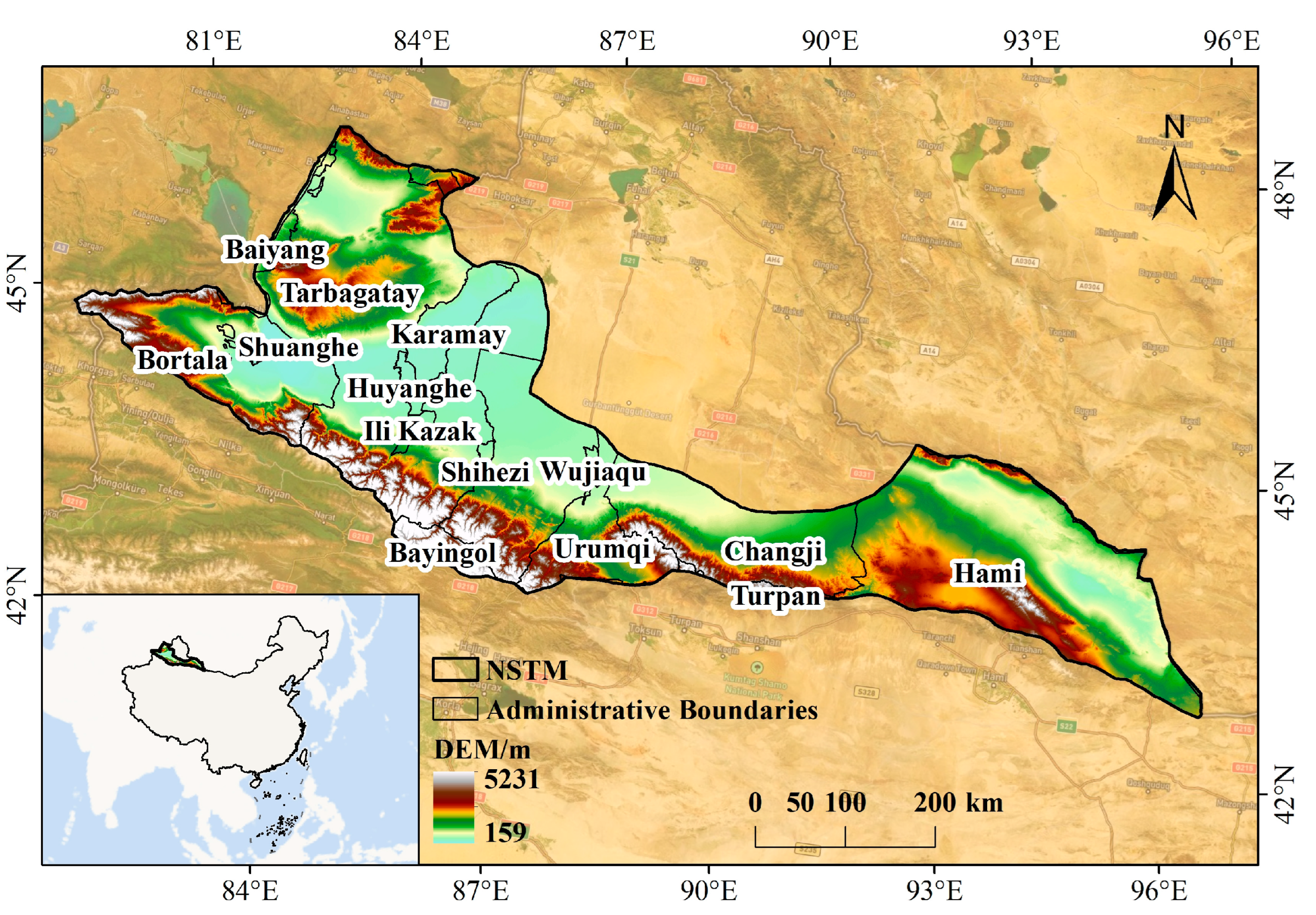
2.1. Study Area

The NSTM is situated in the transitional zone between the northern base of the Tianshan Mountains and the Junggar Basin in northwestern Xinjiang of China between 42°36′ N–47°60′ N and 79°42′ E–96°36′ E [38]. The NSTM is an area that extends along the mountain range, encompassing Urumqi, Changji, Shihezi, Karamay, and Hami (Figure 1). The topography of this region is characterized by a high degree of complexity and diversity, with the terrain exhibiting a southward increase in elevation and a northward decrease. The Tianshan Mountains lie to the south, the alluvial plain occupies the central region, and the Gurbantonggut Desert is situated to the north. The climate of this area is classified as a typical temperate continental climate. The annual temperature range and the daily temperature range are relatively considerable. This area is located in the Tianshan orogenic belt. The geological structure is very different, with high mountains and steep slopes, deep valleys between peaks, and narrow basins, such as Yanqi Basin, Kumish Basin, Sailimu Lake Basin, and Ebinur Lake Lowland. The outlines of these basins or valleys are mostly rhombus or strip-shaped, and their long axis direction is generally consistent with the structural distribution on both sides and the direction of the adjacent ridges.

2.2. Data Sources

The meteorological data were obtained from the China meteorological forcing dataset (1979–2018) [39,40]. The data include daily measurements of wind speed and precipitation. The potential evapotranspiration dataset and snow depth dataset were obtained from the 1 km monthly potential evapotranspiration dataset in China (1901–2023) [41,42,43,44] and long-term series of daily snow depth dataset in China (1979–2023) [45,46,47], respectively. The soil data from the Chinese soil dataset based on the Harmonized World Soil Database (HWSD) (v1.1) [48] were obtained from the National Cryosphere Desert Data Center. Shuttle Radar Topography Mission (SRTM) DEMs with 30 m spatial resolution were utilized in this study. Normalized difference vegetation index (NDVI) data were also utilized to assess vegetation conditions in the NSTM. The monthly NDVI time series data covering the years 2000–2018 and available at 1 km × 1 km spatial resolution were acquired from the Resource and Environmental Science Data Platform. Land use data were obtained from the annual land cover product of China (CLCD) with 30 m resolution (Table 1). All data used were then unified to the same spatial resolution (1 km) and further processed in ArcGIS 10.8 software.

2.3. Revised Wind Erosion Equation

The RWEQ model is a classical model for calculating soil wind erosion. Under the condition of fully considering the weather conditions, soil erodibility, soil crust, soil roughness, vegetation, and other factors, the RWEQ model uses the following formula to estimate the modulus of soil wind erosion [55]:
S L = 2 x S 2 × Q m a x   ×   e     x S   2
Q m a x = 109.8 ( W F × E F × S C F × K × C )
Q x = Q m a x ( 1 e ( x S ) 2 )
S = 150.71 ( W F × E F × S C F × K × C ) 0.3711
where S L is the actual soil wind erosion modulus (kg/m2); x is the distance from the upwind edge of the field, and set to 50 m; Q x is the transport capacity at x distance from the upwind edge of the field (kg/m); Q m a x is the maximum transport capacity (kg/m); when Q x reaches 63.21% of Q m a x , S (m) is called the critical field length. W F is the weather factor (kg/m). E F and S C F are dimensionless soil erodibility factor and dimensionless soil crust factor, respectively; and K and C are dimensionless soil roughness factor and dimensionless vegetation factor, respectively.
Weather Factor ( W F )
The weather factor (WF), reflects the comprehensive influence of various meteorological factors on soil wind erosion, mainly including wind factor, soil wetness factor, snow depth factor and other factors. The W F is calculated as follows:
W F = W f × ρ g × S W × S D
where W F is the weather factor (kg/m); W f is the wind factor (m3/s3); ρ is the air density, set to 1.29 kg/m3; g is the gravity acceleration, set to 9.8 m/s2; S W is the dimensionless soil wetness factor; and S D is the dimensionless snow depth factor.
W f = N d N i = 1 N U 2 U 2 U 1 2
Here, W f is the total sum of wind forces within a period (m3/s3); U 1 is the threshold wind speed at 2 m height (m/s), set to 5 m/s, U 2 is the real wind speed at 2 m height (m/s); when the real wind speed at 2 m height is lower than the threshold wind speed at 2 m height, W f is 0 m3/s3; N equals the total number of wind speed observations, set to the days of every month; and N d is the total number of days within a period (e.g., monthly).
Since the wind speed obtained from the China meteorological forcing dataset [49] is the wind speed at 10 m height, it is necessary to use the wind speed profile equation to convert it to the wind speed at 2 m height:
U 2 = U 10 4.87 l n 67.8 z 5.42 0.748   ×   U 10
where U 2 and U 10 are the wind speed at 2 m height and the wind speed at 10 m height, respectively (m/s), and z indicates the observation height, set to 10 m.
S W = E T p ( R + I ) R d N d E T p
Here, S W is the dimensionless soil wetness factor; E T p is the potential evapotranspiration, calculated by the formula of Hargreaves [56] (mm/month); R is the rainfall (mm/month); I is the irrigation (mm/month), set to 0 mm; R d represents the days of precipitation or irrigation during the measurement period (days); and N d represents the total days during the measurement period (days).
S D = 1 P s n o w d e p t h > 25.4   m m
Here, S D is the dimensionless snow depth factor and P s n o w d e p t h > 25.4   m m represents the probability of a snow depth > 25.4 mm.
Soil Erodibility Factor ( E F )
For soil particles of different sizes, the coarser the particles, the greater the shear force required and the lower the soil erodibility. The presence of organic matter, clay, calcium carbonate, and other substances in the soil will cause the soil particles to form soil aggregates, which can reduce soil erodibility. The E F is calculated as follows:
E F = 29.09 + 0.31 S a + 0.17 S i + 0.33 S a C l 2.59 O M 0.95 C a C O 3 100
where E F is the dimensionless soil erodibility factor; S a represents the sand content (%); S i represents the silt content (%); C l represents the clay content (%); O M represents the organic matter content (%); and C a C O 3 represents the calcium carbonate content (%).
Soil Crust Factor ( S C F )
The soil crust is the cementation of soil particles (especially clay, silt, and organic matter) and forms a layer of soil micro-layers with specific physical, chemical, and biological characteristics on the soil surface. In the process of soil erosion, the presence of crust can reduce the content of erodible particles and reduce the abrasion effect of soil particles, which is conducive to the fixation of sand dunes and the prevention of soil wind erosion. Wind tunnel experiments on soils with different clay and organic matter contents established the quantitative equation of the soil crust factor ( S C F ) [18]. The S C F is calculated as follows:
S C F = 1 1 + 0.0066 C l 2 + 0.021 O M 2
where S C F is the dimensionless soil crust factor; C l represents the clay content (%); and O M represents the organic matter content (%).
Soil Roughness Factor ( K )
Soil roughness mainly refers to the formation of massive soil and the existence of soil ridges caused by tillage in farmland, which change the surface conditions and have a certain impact on soil wind erosion.
The soil roughness factor ( K ) is measured by the chain method [57]. The ridge/oriented roughness ( K r ) and the aggregate/random roughness ( C r r ) are calculated by the Smith–Carson equation [58]. The K’ is calculated as follows:
K = e 1.86 K r 2.41 K r 0.934 0.127 C r r
K r = 0.2 × H 2 L
where K is the dimensionless soil roughness factor; K r is the ridge/oriented roughness (cm); C r r is the aggregate/random roughness (cm), set to 0 cm; H is the difference between the minimum and maximum elevations in the selected area (cm); and L is the length of the edge of the area (cm).
Vegetation Factor ( C )
Vegetation cover is a key factor influencing the occurrence of soil wind erosion, and the degree of cover has a direct effect on near-surface wind speed and soil roughness. Vegetation can improve surface roughness and at the same time has a certain obstructing effect on moving object particles [59]. The C is calculated as follows:
C = e a i S C
where C is the vegetation factor; S C is the monthly fraction of vegetation cover (%); and ai is the dimensionless coefficient of different vegetation types: forest taking −0.1535, grass taking −0.1151, shrub taking −0.0921, barren taking −0.0768, desert taking −0.0658, and cropland taking −0.0438.
In addition, S C is calculated by an approach using the following equation:
S C = N D V I N D V I m i n N D V I m a x N D V I m i n
where N D V I m a x and N D V I m i n represent the end-member N D V I values for the vegetation and soil spectral.

2.4. Classification of Soil Wind Erosion Intensity

The classifications of soil wind erosion intensity were expressed according to standards for classification and gradation of soil erosion (SL190–2007) [60] (Table 2).

2.5. Statistical Analysis

2.5.1. Mann–Kendall Trend Test

The Mann–Kendall (MK) trend test has the characteristics that it does not need to follow a specific sample distribution and is not affected by a few outliers. Compared with other methods, it is easier to calculate. Therefore, it can reflect the rise and fall in time series trends and show the degree of trend change well [61].
For time series variables x 1 , x 2 , ……, x n , their inspection statistic S is:
S = k = 1 n 1 j = k + 1 n S g n x j x k
S g n x j x k = 1   x j x k > 0 0   x j x k = 0 1 x j x k < 0
where S presents a normal distribution and the mean value is equal to 0.
v a r S = n n 1 2 n + 5 18
When n > 10, the standard normal statistical variable Z is:
Z = S 1 v a r S S > 0 0 S = 0 S + 1 v a r S S < 0
When the Z value is greater than 0, it means that the time series shows an increasing trend and when the Z value is less than 0, it means that the time series shows a decreasing trend. When | Z | ≥ 1.96, 2.58, it means that the time series has passed the significance test with confidence levels of 95% and 99%, respectively. | Z | ≥ 2.58 indicates that the change trend of the time series is extremely significant; 1.96 ≤ | Z | ≤ 2.58 indicates that the change trend of the time series is significant; and 0 ≤ | Z | ≤ 1.96 indicates that the change trend of the time series is non-significant.

2.5.2. Spearman’s Correlation Coefficient ( r )

The linear relationship between variables is quantified by calculating Spearman’s correlation coefficient ( r ) [62]:
r = i = 1 n ( X i X ¯ ) ( Y i Y ¯ ) i = 1 n ( X i X ¯ ) 2 i = 1 n ( Y i Y ¯ ) 2
where X i is the i-th sample value of variable X, X ¯ is the sample mean of variable X, Y i is the i-th sample value of variable Y, and Y ¯ ¯ is the sample mean of variable Y.

2.5.3. Land Use Transition Matrix

The land use transition matrix reflects the land use transformation of a given area in a given period between the start and the end of the period, providing dynamic process information on land use change [63]. It includes not only the area data of different land uses at a given time but also the area transfers between different land uses.
The general form of the land use transition matrix can be expressed as:
S i j = S 11 S 12 S 1 n S 21 S 22 S 2 n S n 1 S n 2 S n n
where S i j represents the area of land converted from type i land before the transfer to type j land after the transfer; N is the number of land use types; and i and j are the land use before the transfer and the land use after the transfer, respectively.

2.5.4. Geodetector

Geodetector is a new spatial statistical method to detect spatially stratified heterogeneity and reveal the driving factors [64]. This research mainly explores the driving factors of soil wind erosion in the NSTM by using the factor detector and interaction detector of Geodetector.
The factor detector result can indicate to what extent factor X explains the spatial divergence of attribute Y, and can be quantified by q value:
q = 1 h = 1 L N h σ h 2 N σ 2 = 1 S S W S S T
S S W = h = 1 L N h σ h 2 ,   S S T = N σ 2
where h = 1, …, L is the classification of variable Y or factor X; N h and N are the number of units of classification h and the whole region, respectively; σ h 2 and σ 2 are the variances of classification h and Y of the whole region, respectively; and SSW and SST are the sum of variances within the classification and the sum of variances of the whole region, respectively. The range of q is [0, 1], and the larger the value, the stronger the spatial differentiation of the variable Y; if the classification is generated by the explanatory variable X, the larger the q value, the stronger the explanatory power of the explanatory variable X for the response variable Y, and vice versa.
The interaction detector is used to identify the interaction between variables to evaluate the explanatory power of the joint and independent effects of each explanatory variable on the response variable (Table 3).

3. Results

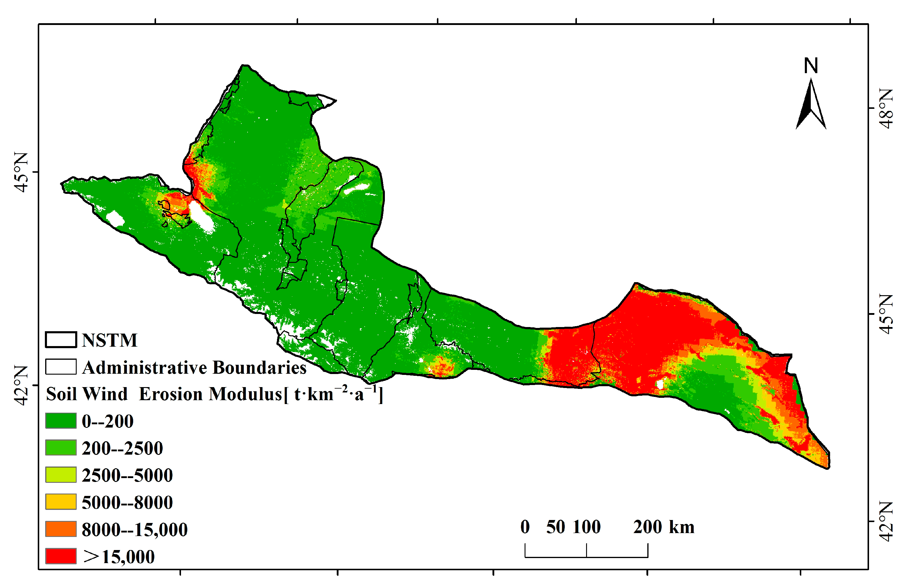
3.1. Spatial Distribution Pattern of Soil Wind Erosion in the NSTM

From 2000 to 2018, the area affected by soil wind erosion in the NSTM was about 2.14 × 10⁵ km2, accounting for about 94.25% of the total area. The multi-year average actual soil wind erosion modulus was about 6556.40 t·km−2·a−1. The main types of soil wind erosion in the study area are tolerable erosion (<200 t·km−2·a−1) and light erosion (200–2500 t·km−2·a−1), accounting for about 74.76% of the study area, followed by destructive erosion (>15,000 t·km−2·a−1), accounting for about 15.80% of the study area. The proportion of the area with light erosion and destructive erosion is less than 10%.
Tolerable erosion and light erosion are mainly distributed in the central and northern parts of the NSTM and the central part of the Turpan Basin. Destructive erosion is mainly concentrated in the eastern part of the NSTM, including the eastern part of Changji, the western part of Hami, the northern part of Bortala, the western part of Tacheng, and the eastern part of Urumqi. Moreover, very severe erosion (8000–15,000 t·km−2·a−1), severe erosion (5000–8000 t·km−2·a−1), and moderate erosion (2500–5000 t·km−2·a−1) are roughly distributed in the zone where destructive erosion is excessive to light erosion (Figure 2).

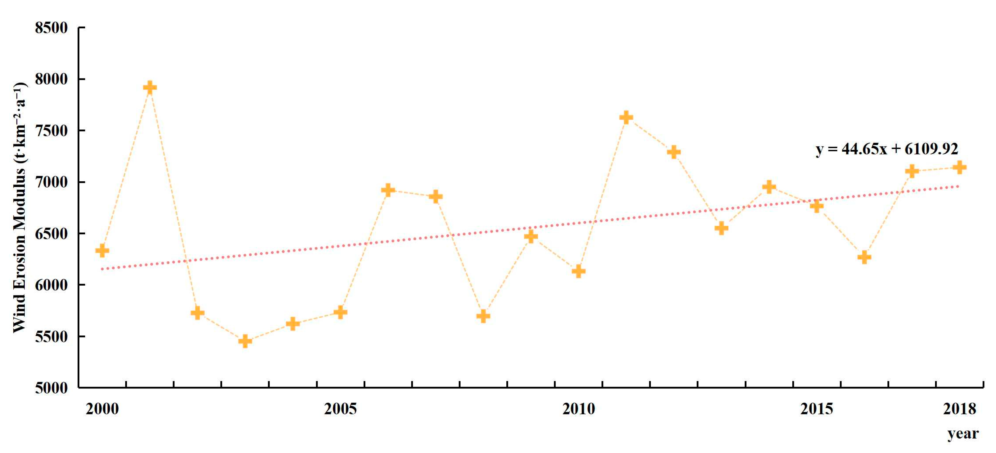
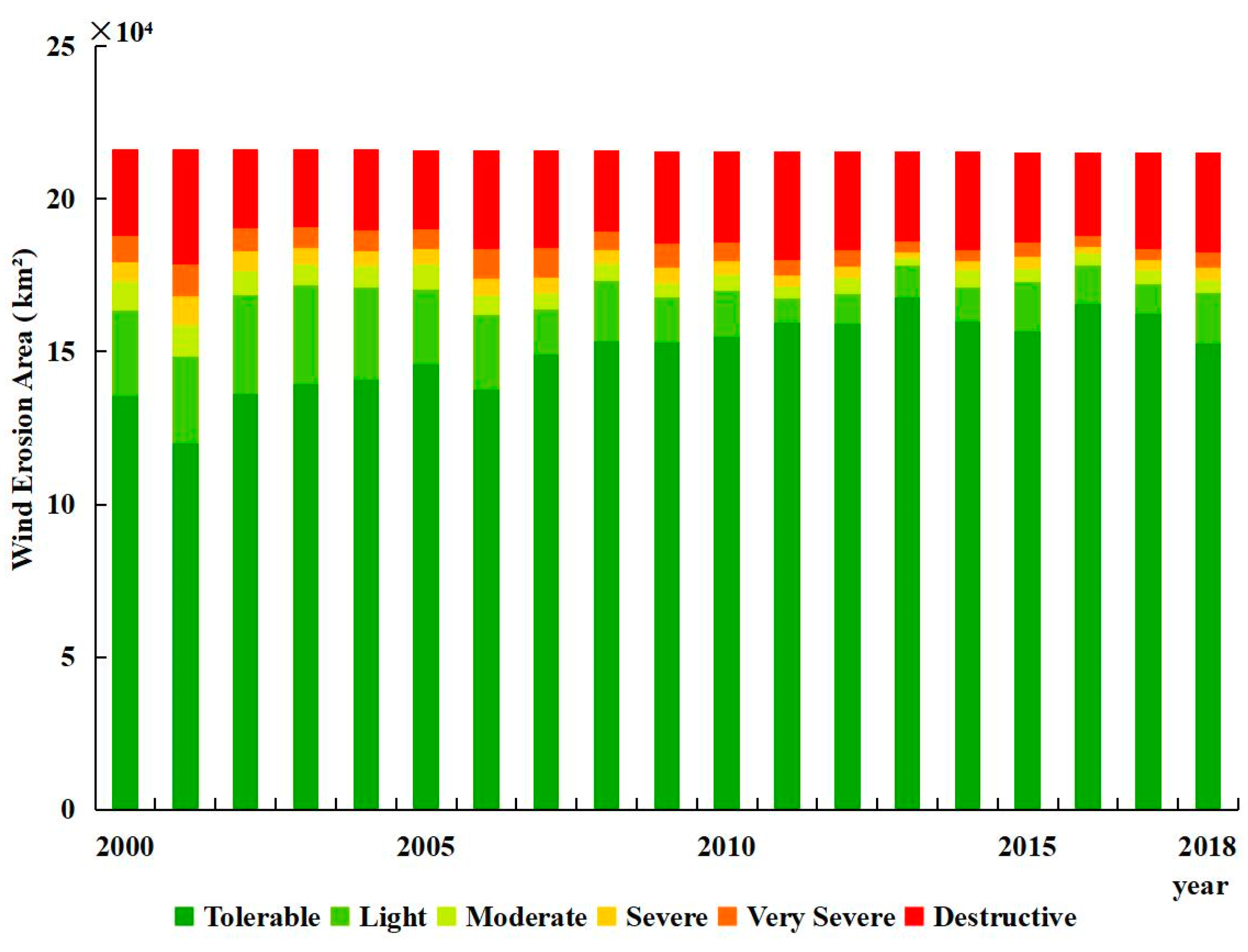
3.2. Temporal Dynamics of Soil Wind Erosion in the NSTM

From 2000 to 2018, the actual soil wind erosion modulus in the NSTM showed a trend of fluctuational increase with an increase rate of 44.65 t·km−2·a−2. The largest actual soil wind erosion modulus was 7918.34 t·km−2·a−1 in 2001, and the smallest actual soil wind erosion modulus was 5452.87 t·km−2·a−1 in 2003 (Figure 3).
The change trends of the area with different soil wind erosion intensities were different. Tolerable erosion (<200 t·km−2·a−1) and destructive erosion (>15,000 t·km−2·a−1) showed an upward trend, but the increasing rate of tolerable erosion was higher than that of destructive erosion, and the increasing rate of tolerable erosion and destructive erosion were 908.79 km2·a−1 and 242.11 km2·a−1, respectively. The areas with light erosion (200–2500 t·km−2·a−1), moderate erosion (2500–5000 t·km−2·a−1), severe erosion (5000–8000 t·km−2·a−1) and very severe erosion (8000–15,000 t·km−2·a−1) all showed downward trends (Figure 4).

3.3. Spatiotemporal Trends of Soil Wind Erosion in the NSTM

Figure 5 shows the spatial distribution characteristics of the change trend of the actual soil wind erosion modulus in the NSTM from 2000 to 2018. The results showed that the actual soil wind erosion modulus in the NSTM was mainly decreased. The areas with extremely significant decrease, significant decrease, and non-significant decrease account for about 76.38% of the total area, of which the area of extremely significant decrease accounts for 32.13%, mainly distributed in the northern part of Bortala, the western part of Tacheng and Karamay, the northern part of Urumqi, and the western part of Changji. In addition, the accumulated area with extremely significant increase, significant increase, and non-significant increase accounts for about 23.62% of the total area, of which the area with extremely significant increase accounts for 8.42%, which is mainly concentrated in the northern part of Hami (Figure 5).

4. Discussion

4.1. The Reliability of This Study

Based on the National Ecological Environmental Standards of the People’s Republic of China, the RWEQ was used to obtain the temporal and spatial changes in soil wind erosion in the NSTM, which can be reliable. Compared with the existing literature on a larger scale, the spatial distribution patterns of soil wind erosion in this study are similar to the distribution of soil wind erosion in Central Asia [65]. The multi-year average actual soil wind erosion modulus in the NSTM from 2000 to 2018 is 6556.40 t·km−2·a−1. Compared with the existing literature on a similar scale but in different regions, the multi-year average value is relatively higher than the 4470.64 t·km−2·a−1 in the Zhundong area of Xinjiang from 2008 to 2014 calculated by using WEQ [66]. The NSTM in this paper includes part of the Zhundong area, but does not cover the entire Zhundong area, and thus the differences in multi-year average actual soil wind erosion modulus can be attributed to the regional differences. The variations in the structure of WEQ and RWEQ can also contribute to these differences. Compared with the multi-year average soil wind erosion modulus of 274.83 to 4537.20 t·km−2·a−1 in the Tarim River Basin of Xinjiang from 2010 to 2018, the results of this study in the NSTM of Xinjiang are also relatively higher [67], which is because of the regional differences. The Tarim River Basin is located on the south side of the Tianshan Mountains with different climate, topography, and land use conditions, which can lead to differences in quantitative simulation results of soil wind erosion.
Ding et al. (2018) used 137Cs to measure the wind erosion rate in the Zhundong area of Xinjiang [68]. Among all the sample sites, there are two sites included in the NSTM with different land use. The soil wind erosion rates of these two sites simulated by RWEQ in this study (ZHD01 and ZHD02) were 83.8 t·km−2·a−1 and 83.9 t·km−2·a−1, respectively, which are lower than the field measurement results of 137Cs, but the numbers in this study are similar to the RWEQ model estimates of the previous study [65], whose soil wind erosion rates on these two sites are 88.6 t·km−2·a−1 and 86.6 t·km−2·a−1, respectively. Due to the limitations of local conditions such as vegetation, soil particle size structure, topography, and tillage practices, the simulation results may contain a certain degree of uncertainty compared to the measurements by the 137Cs method. However, considering the scale effect, the estimation results of the RWEQ model still have a certain reference significance for understanding the spatial and temporal changes in soil wind erosion.

4.2. The Drivers of Soil Wind Erosion in the NSTM

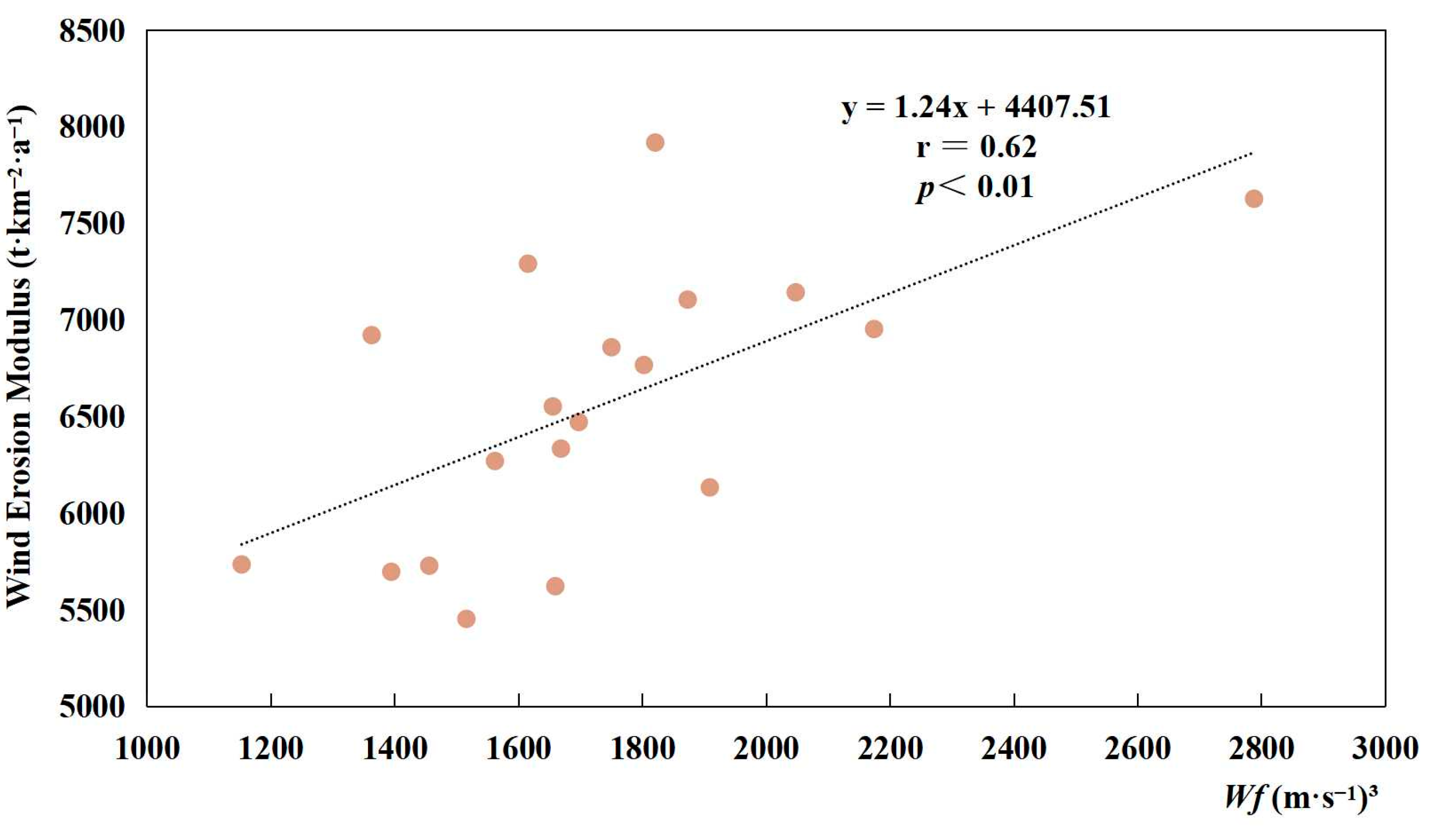
4.2.1. The Impact of Wind Factor on Soil Wind Erosion

From 2000 to 2018, the amount of soil wind erosion in the NSTM showed a fluctuating upward trend (Figure 3), and interannual variation in wind factor was generally consistent with the change trend of the actual soil wind erosion modulus. A significant positive correlation (r = 0.62, p < 0.01) was found between them (Figure 6). Although weather factors such as potential evapotranspiration, precipitation, and snow depth also have some influence on soil wind erosion, their influence is relatively weak on the interannual scale in the NSTM.

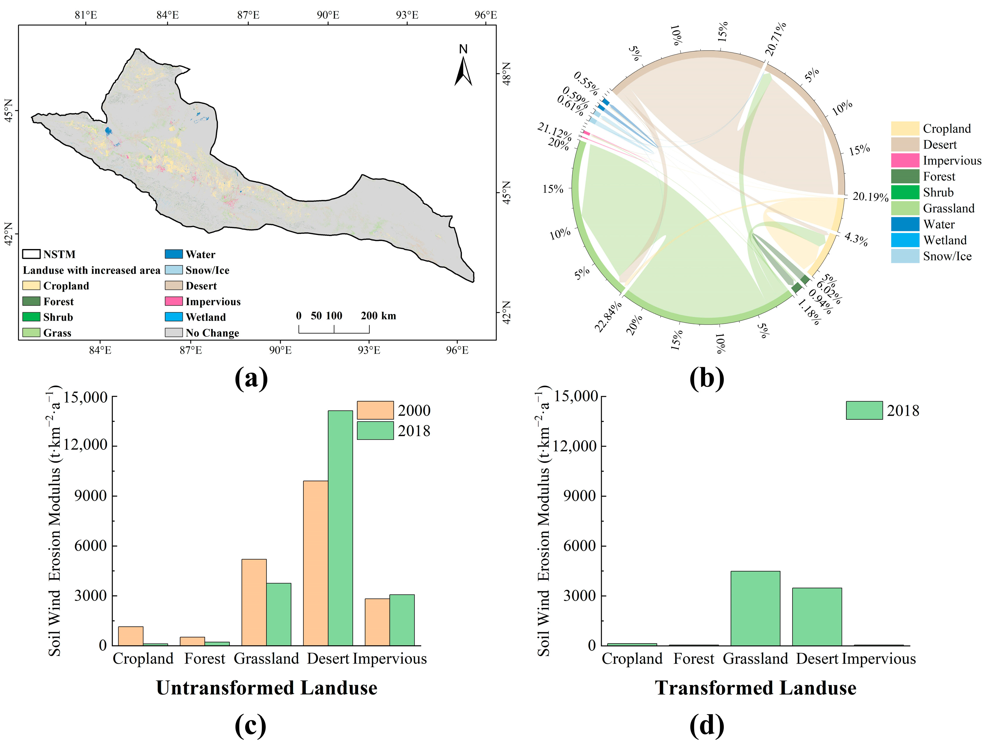
4.2.2. The Impact of Land Use on the Soil Wind Erosion

Land use changes are extensively related to the soil wind erosion rates [35]. By comparing the land use maps of 2000 and 2018, the land use transfer conditions were obtained (Figure 7). From 2000 to 2018, the area with transferred land use in the NSTM was about 1.02 × 10⁴ km2, accounting for 4.51% of the total area. The transfer-out areas of grass and desert accounted for 75.87% and 23.12% of the total transferred area, respectively. The transfer-in areas of cropland, forest, and impervious land accounted for 75.68%, 10.39%, and 10.06% of the total transformed area, respectively. In addition, 7577.91 km2 of grass and 2553.91 km2 of desert were converted into cropland, which became the main source of newly increased cropland, mainly distributed in the middle part of the NSTM. At the same time, the area of impervious land increased by 1030.22 km2, of which grassland is the main source, accounting for 42.39% (Figure 7a,b).
Figure 7c,d show the actual soil wind erosion modulus for different land uses in the untransformed area and transformed area. Within the untransformed area, which accounted for more than 95% of the total area (Figure 7c), the actual soil wind erosion modulus decreased on cropland, forest, and grassland but increased on desert and impervious land from 2000 to 2018. Especially on desert land, the soil wind erosion modulus increased by 42.6% from 9909.87 t·km−2·a−1 to 14,132.79 t·km−2·a−1, which led to the fluctuating increase in soil wind erosion modulus in the study area. Through further investigation, it was found that the wind factor in the desert area has increased from 1668.48 m3·s−3 in 2000 to 2047.56 m3·s−3 in 2018, an increase of 22.72%. Combined with the analysis results in Section 4.2.1, the wind factor had a significant positive correlation with the soil wind erosion modulus. Therefore, the intensification of soil wind erosion intensity in desert area can be partially attributed to the climate factor. The impact of human activities and the quantification of contributions from different factors need to be further investigated.
While within the transformed area, the actual soil wind erosion modulus in 2018 was highest on grassland (4489.90 t·km−2·a−1), followed by desert (3478.55 t·km−2·a−1), the wind erosion modulus on cropland, forest, and impervious land were relatively low. This can be attributed to the fact that most of the newly increased grassland is converted from desert, and the soil wind erosion modulus is still relatively high.

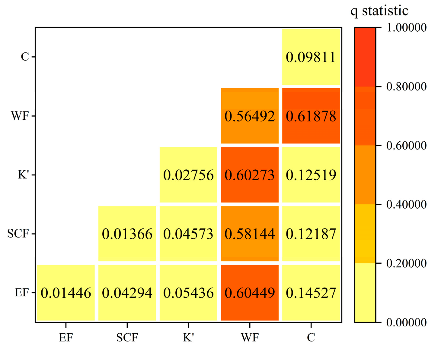
4.2.3. Interaction of Influencing Factors of Soil Wind Erosion

The results of the interaction detector show that the interaction of the two influencing factors will enhance the explanatory power of soil wind erosion. The interaction of the weather factor and the vegetation factor best explained the soil wind erosion changes, with the explanatory force reaching 61.88%. At the same time, the impact of the weather factor on soil wind erosion after interacting with all factors was significantly greater than that of the weather factor alone. In addition, compared with other influencing factors, the soil erodibility factor, soil crust factor, and soil roughness factor had relatively small impacts on soil wind erosion alone. After interacting with the weather factor, they all showed significant non-linear enhancement, and the explanatory power of soil wind erosion soared to more than 58% (Figure 8).
Since the interaction of the weather factor and vegetation factor can explain 61.88% of the soil wind erosion in the study area, and the most important factor among the weather factors is the wind factor, then the wind speed can be reduced by planting windbreak forest belts or installing grass grids and other physical obstacles, thereby reducing wind erosion. In addition, vegetation is one of the key factors in reducing soil wind erosion. Vegetation restoration projects, such as afforestation and grassland planting, can increase land cover and reduce the risk of direct soil exposure to wind erosion.

4.3. Limitation of This Study

Based on the RWEQ model, this study carried out quantitative estimation of the soil wind erosion modulus in the NSTM, but there are still some deficiencies and limitations that need to be identified and further studied. (1) The meteorological data used in this study are mainly from a single dataset, but the applicability of this dataset in the study area was not assessed, which may introduce uncertainties into the results. (2) The RWEQ model is an empirical model that has been developed in the United States. Due to the differences in soil particle size classification systems and farmland management measures, the revision of parameters needs further research. (3) Soil wind erosion is a complex process and the result of the combined impact of multiple driving factors. Many sand prevention and sand fixation projects have been implemented in the NSTM, such as nylon mesh, stone and woven bag sand barriers, and other engineering measures, which have effectively intercepted wind and sand. Limited by the difficulty of sand prevention data collection, this study did not consider these human impact factors. In conclusion, the soil wind erosion modulus in this study mainly reflects the soil wind erosion caused by weather factors and vegetation factors in the study area. Future research on soil wind erosion needs to focus on improving input data accuracy, revising model parameters, and introducing more factors reflecting human activities.

5. Conclusions

In this study, the RWEQ was used to characterize the temporal and spatial changes in soil wind erosion in the NSTM from 2000 to 2018. The main conclusions are as follows.
(1) The multi-year average actual soil wind erosion modulus was about 6556.40 t·km−2·a−1. From 2000 to 2018, the actual soil wind erosion modulus in the NSTM showed a trend of fluctuational increase with an increase rate of 44.65 t·km−2·a−2. The intensity of soil wind erosion in some areas (for example, Hami) tended to intensify.
(2) The interannual variation in wind factor was generally consistent with the change trend of the multi-year actual soil wind erosion modulus, and the two showed a relatively significant positive correlation (r = 0.62, p < 0.01).
(3) Land use changed on about 4.51% of the total area in the NSTM. Within the untransformed area, the actual soil wind erosion modulus on desert land increased by 42.6% from 2000 to 2018, which led to the increase in soil wind erosion modulus as a whole.
(4) The interaction of the weather factor (WF) and the vegetation factor (C) best explained the soil wind erosion changes, with the explanatory force reaching 61.88%.
This study reveals that the RWEQ is useful to assess the spatial and temporal distributions of the soil wind erosion rates in the NSTM. For future studies, the adaptability of the RWEQ model in different environments should be assessed to enhance the understanding of soil wind erosion in various environments.

Author Contributions

Conceptualization, X.X.; methodology, S.W. and X.X.; formal analysis, S.W.; writing—original draft preparation, S.W.; writing—review and editing, X.X.; funding acquisition, X.X. All authors have read and agreed to the published version of the manuscript.

Funding

This research was funded by the Third Xinjiang Scientific Expedition Program (2021xjkk0805) and the National Natural Science Foundation of China (42277339).

Data Availability Statement

The original data of the wind speed or precipitation presented in the study are available at DOI: 10.11888/AtmosphericPhysics.tpe.249369.file. The original data of the potential evapotranspiration are available at DOI: 10.11866/db.loess.2021.001. The original data of the snow depth presented in the study are openly available at DOI: 10.11888/Geogra.tpdc.270194. The original soil data are available at DOI: 10.12072/ncdc.westdc.db3647.2023. The original data of the NDVI are available at DOI: 10.12078/2018060602. The original data of land use are available at DOI: 10.5281/zenodo.5816591.

Conflicts of Interest

The authors declare no conflicts of interest.

References

  1. Lal, R. Soil Erosion and the Global Carbon Budget. Environ. Int. 2023, 29, 437–450. [Google Scholar] [CrossRef] [PubMed]
  2. Field, J.P.; Belnap, J.; Breshears, D.D.; Neff, J.C.; Okin, G.S.; Whicker, J.J.; Painter, T.H.; Ravi, S.; Reheis, M.C.; Reynolds, R.L. The Ecology of Dust. Front. Ecol. Environ. 2010, 8, 423–430. [Google Scholar] [CrossRef]
  3. Qian, W.H.; Quan, L.S.; Shi, S.Y. Variations of the Dust Storm in China and its Climatic Control. J. Clim. 2002, 15, 1216–1229. [Google Scholar] [CrossRef]
  4. Buschiazzo, D.E.; Zobeck, T.M. Validation of WEQ, RWEQ and WEPS Wind Erosion for Different Arable Land Management Systems in the Argentinean Pampas. Earth. Surf. Process. Landf. 2008, 33, 1839–1850. [Google Scholar] [CrossRef]
  5. Chepil, W.S. Dynamics of Wind Erosion: I. Nature of Movement of Soil by Wind. Soil Sci. 1945, 60, 305–320. [Google Scholar] [CrossRef]
  6. Du, H.D.; Jiao, J.Y.; Jia, Y.F.; Wang, N.; Wang, D.L. Phytogenic Mounds of Four Typical Shoot Architecture Species at Different Slope Gradients on the Loess Plateau of China. Geomorphology 2013, 193, 57–64. [Google Scholar] [CrossRef]
  7. Wu, Z.T.; Wang, M.Y.; Zhang, H.; Du, Z.Q. Vegetation and Soil Wind Erosion Dynamics of Sandstorm Control Programs in the Agro-Pastoral Transitional Zone of Northern China. Front. Earth Sci. 2019, 13, 430–443. [Google Scholar] [CrossRef]
  8. Yin, Z.C.; Wan, Y.; Zhang, Y.J.; Wang, H.J. Why super sandstorm 2021 in North China. Natl. Sci. Rev. 2021, 9, nwab165. [Google Scholar] [CrossRef]
  9. Cook, B.I.; Miller, R.L.; Seager, R. Dust and Sea Surface Temperature Forcing of the 1930s “Dust Bowl” Drought. Geophys. Res. Lett. 2008, 35, 114–118. [Google Scholar] [CrossRef]
  10. Copeland, N.S.; Sharratt, B.S.; Wu, J.Q.; Foltz, R.B.; Dooley, J.H. A Wood-Strand Material for Wind Erosion Control: Effects on Total Sediment Loss, PM10 Vertical Flux, and PM10 Loss. J. Environ. Qual. 2009, 38, 139–148. [Google Scholar] [CrossRef]
  11. Bartkowski, B.; Schepanski, K.; Bredenbeck, S.; Müller, B. Wind Erosion in European Agricultural Landscapes: More than Physics. People Nat. 2023, 5, 34–44. [Google Scholar] [CrossRef]
  12. Furieri, B.; Russeil, S.; Santos, J.M.; Harion, J.L. Effects of Non-Erodible Particles on Aeolian Erosion: Wind-Tunnel Simulations of a Sand Oblong Storage Pile. Atmos. Environ. 2013, 79, 672–680. [Google Scholar] [CrossRef]
  13. Giménez, A.; Lozano, F.J.; Torres, J.A.; Asensio, C. Automated System for Soil Wind Erosion Studies. Comput. Electron. Agric. 2019, 164, 104889. [Google Scholar] [CrossRef]
  14. Liu, J.Y.; Qi, Y.Q.; Shi, H.D.; Zhuang, D.F.; Hu, Y.F. Estimation of Wind Erosion Rates by Using 137 Cs Tracing Technique: A Case Study in Tariat-Xilin Gol Transect, Mongolian Plateau. Chin. Sci. Bull. 2008, 53, 751–758. [Google Scholar] [CrossRef]
  15. Jarrah, M.; Mayel, S.; Tatarko, J.; Funk, R.; Kuka, K. A Review of Wind Erosion Models: Data Requirements, Processes, and Validity. Catena 2020, 187, 104388. [Google Scholar] [CrossRef]
  16. Woodruff, N.P.; Siddoway, F.H. A Wind Erosion Equation. Soil Sci. Soc. Am. J. 1965, 29, 602–608. [Google Scholar] [CrossRef]
  17. Williams, J.R.; Jones, C.A.; Dyke, P.T. A Modeling Approach to Determining the Relationship Between Erosion and Soil Productivity. Trans. ASAE. 1984, 27, 129–144. [Google Scholar] [CrossRef]
  18. Hagen, L.J. A Wind Erosion Prediction System to Meet User Needs. J. Soil Water Conserv. 1991, 46, 106–111. [Google Scholar]
  19. Fryrear, D.W.; Chen, W.N.; Lester, C. Revised Wind Erosion Equation. Ann. Arid Zone 2001, 40, 265–279. [Google Scholar]
  20. Gregory, J.; Wilson, G.; Singh, U.; Darwish, M. TEAM: Integrated, Process-Based Wind-Erosion Model. Environ. Model. Softw. 2004, 19, 205–215. [Google Scholar] [CrossRef]
  21. Tatarko, J.; Wagner, L.; Fox, F. The Wind Erosion Prediction System and Its Use in Conservation Planning. In Bridging Among Disciplines by Synthesizing Soil and Plant Processes; Wendroth, O., Lascano, R.J., Ma, L., Eds.; American Society of Agronomy, Inc., Soil Science Society of America, Inc., Crop Science Society of America, Inc.: Madison, WI, USA, 2019; Volume 8, pp. 71–101. [Google Scholar]
  22. Mandakh, N.; Tsogtbaatar, J.; Dash, D.; Khudulmur, S. Spatial assessment of soil wind erosion using WEQ approach in Mongulia. J. Geographic.Sci. 2016, 26, 473–483. [Google Scholar] [CrossRef]
  23. Liu, J.; Guo, Z.L.; Chang, C.P.; Wang, R.D.; Li, J.F.; Li, Q.; Wang, X.Y. Potential Wind Erosion Simulation in the Agro-Pastoral Ecotone of Northern China Using RWEQ and WEPS Models. J. Desert Res. 2021, 41, 27–37. (In Chinese) [Google Scholar] [CrossRef]
  24. Ma, Y.L.; Wang, Z.D.; Zhang, J.Q.; Xu, Y.S.; Li, Y.Y. Effect of Moss Crust Coverage and Spatial Distribution on Soil Wind Erosion Using Wind Tunnel Experiments and Simulations. J. Desert Res. 2023, 43, 97–107. (In Chinese) [Google Scholar] [CrossRef]
  25. Gong, G.L.; Liu, J.Y.; Shao, Q.Q. Effects of Vegetation Coverage Change on Soil Conservation Service of Typical Steppe in Inner Mongolia. Geo-Inf. Sci. 2014, 16, 426–434. (In Chinese) [Google Scholar]
  26. Gong, G.L.; Liu, J.Y.; Shao, Q.Q. Wind erosion in Xilingol League, Inner Mongolia since the 1990s using the Revised Wind Erosion Equation. Prog. Geogr. 2014, 33, 825–834. (In Chinese) [Google Scholar] [CrossRef]
  27. Gong, G.L.; Liu, J.Y.; Shao, Q.Q.; Zhai, J. Sand-Fixing Function under the Change of Vegetation Coverage in a Wind Erosion Area in Northern China. J. Resour. Ecol. 2014, 5, 105–114. (In Chinese) [Google Scholar] [CrossRef]
  28. Jiang, L.; Xiao, Y.; Ouyang, Z.Y.; Xu, W.H.; Zhen, H. Estimate of the Wind Erosion Modulus in Qinghai Province Based on RWEQ Model. Res. Soil Water Conserv. 2015, 22, 21–25+32+2. (In Chinese) [Google Scholar] [CrossRef]
  29. Jiang, L.; Xiao, Y.; Zheng, H.; Ouyang, Z.Y. Spatio-Temporal Variation of Wind Erosion in Inner Mongolia of China between 2001 and 2010. Chin. Geogr. Sci. 2016, 26, 155–164. [Google Scholar] [CrossRef]
  30. Shen, L.; Tian, M.R.; Gao, J.X.; Qian, J.P. Spatio-Temporal Change of Sand-Fixing Fuction and Its Driving Forces in Desertification Control Ecological Function Area of Hunshandake, China. Chin. J. Appl. Ecol. 2016, 27, 73–82. (In Chinese) [Google Scholar] [CrossRef]
  31. Shen, L.; Tian, M.R.; Gao, J.X. Analysis on Wind Erosion and Main Factors in Desertification Control Ecological Function Area of Hunshandake Using the Revised Wind Erosion Equation Model. Res. Soil Water Conserv. 2016, 23, 90–97. (In Chinese) [Google Scholar] [CrossRef]
  32. Zhang, L.; Guo, Z.L.; Li, J.F.; Chang, C.P.; Wang, R.D.; Li, Q. Effect of the Type of Wind Data on Regional Potential Wind Erosion Estimation. Front. Environ. Sci. 2022, 10, 847128. [Google Scholar] [CrossRef]
  33. Du, H.Q.; Zuo, X.A.; Li, S.; Wang, T.; Xue, X. Wind Erosion Changes Induced by Different Grazing Intensities in the Desert Steppe, Northern China. Agric. Ecosyst. Environ. 2019, 274, 1–13. [Google Scholar] [CrossRef]
  34. Li, D.J.; Xu, E.Q.; Zhang, H.Q. Influence of Ecological Land Change on Wind Erosion Prevention Service in Arid Area of Northwest China from 1990 to 2015. Ecol. Indic. 2020, 117, 106686. [Google Scholar] [CrossRef]
  35. Guo, Z.Q.; Yan, Z.J.; He, R.; Yang, H.; Ci, H.; Wang, R. Impacts of Land Use Conversion on Soil Erosion in the Urban Agglomeration on the Northern Slopes of the Tianshan Mountains. Land 2024, 13, 550. [Google Scholar] [CrossRef]
  36. Wei, W.Y.; Liu, Y.; Zhang, L.X.; Li, L.H. Distribution Assessment of Soil Erosion with Revised RUSLE Model in Tianshan Mountains. J. Mt. Sci. 2024, 21, 850–866. [Google Scholar] [CrossRef]
  37. Zhang, X.Y.; Wu, S.X. Spatial-temporal Dynamics of Desertification in Typical Region of Oasis to Desert in Northern Piedmont of Tianshan Mountains. J. Desert Res. 2006, 26, 208–214. (In Chinese) [Google Scholar]
  38. Tang, Q.H.; Liu, X.C.; Zhou, Y.Y.; Wang, P.Y.; Li, Z.Q.; Hao, Z.X.; Liu, S.X.; Zhao, G.; Zhu, B.Q.; He, X.L.; et al. Climate Change and Water Security in the Northern Slope of the Tianshan Mountains. Geo. Sus. 2022, 3, 246–257. [Google Scholar] [CrossRef]
  39. He, J.; Yang, K.; Tang, W.J.; Lu, H.; Qin, J.; Chen, Y.Y.; Li, X. The First High-Resolution Meteorological Forcing Dataset for Land Process Studies over China. Sci. Data 2020, 7, 25. [Google Scholar] [CrossRef]
  40. Yang, K.; He, J.; Tang, W.J.; Qin, J.; Cheng, C.C.K. On Downward Shortwave and Longwave Radiations over High Altitude Regions: Observation and Modeling in the Tibetan Plateau. Agric. For. Meteorol. 2010, 150, 38–46. [Google Scholar] [CrossRef]
  41. Peng, S.Z.; Ding, Y.X.; Wen, Z.M.; Chen, Y.M.; Cao, Y.; Ren, J.Y. Spatiotemporal Change and Trend Analysis of Potential Evapotranspiration over the Loess Plateau of China during 2011-2100. Agric. For. Meteorol. 2017, 233, 183–194. [Google Scholar] [CrossRef]
  42. Ding, Y.X.; Peng, S.Z. Spatiotemporal Trends and Attribution of Drought across China from 1901–2100. Sustainability 2020, 12, 477. [Google Scholar] [CrossRef]
  43. Ding, Y.X.; Peng, S.Z. Spatiotemporal Change and Attribution of Potential Evapotranspiration over China from 1901 to 2100. Theor. Appl. Climatol. 2021, 145, 79–94. [Google Scholar] [CrossRef]
  44. Peng, S.Z.; Ding, Y.X.; Liu, W.Z.; Li, Z. 1 Km Monthly Temperature and Precipitation Dataset for China from 1901 to 2017. Earth Syst. Sci. Data 2019, 11, 1931–1946. [Google Scholar] [CrossRef]
  45. Che, T.; Li, X.; Jin, R.; Armstrong, R.; Zhang, T.J. Snow depth derived from passive microwave remote-sensing data in China. Ann. Glaciol. 2008, 49, 145–154. [Google Scholar] [CrossRef]
  46. Dai, L.Y.; Che, T.; Ding, Y.J. Inter-calibrating SMMR, SSM/I and SSMI/S data to improve the consistency of snow-depth products in China. Remote Sens. 2015, 7, 7212–7230. [Google Scholar] [CrossRef]
  47. Dai, L.Y.; Che, T.; Ding, Y.J.; Hao, X.H. Evaluation of snow cover and snow depth on the Qinghai–Tibetan Plateau derived from passive microwave remote sensing. Cryosphere 2017, 11, 1933–1948. [Google Scholar] [CrossRef]
  48. Fischer, G.; Nachtergaele, F.; Prieler, S.; van Velthuizen, H.T.; Verelst, L.; Wiberg, D. Global Agro-Ecological Zones Assessment for Agriculture (GAEZ 2008); IIASA: Laxenburg, Austria; FAO: Rome, Italy, 2008. [Google Scholar]
  49. China Meteorological Forcing Dataset (1979–2018). Available online: https://data.tpdc.ac.cn/en/data/8028b944-daaa-4511-8769-965612652c49 (accessed on 20 November 2023).
  50. 1 km Monthly Potential Evapotranspiration Dataset in China (1901–2023). Available online: https://loess.geodata.cn/data/datadetails.html?dataguid=34595274939620&docid=74 (accessed on 20 November 2023).
  51. Long-Term Series of Daily Snow Depth Dataset in China (1979–2023). Available online: https://data.tpdc.ac.cn/en/data/df40346a-0202-4ed2-bb07-b65dfcda9368/ (accessed on 20 November 2023).
  52. Chinese Soil Dataset Based on the World Soil Database (HWSD) (v1.1). Available online: http://www.ncdc.ac.cn/portal/metadata/a948627d-4b71-4f68-b1b6-fe02e302af09 (accessed on 20 November 2023).
  53. China Monthly 250 m Vegetation Index (NDVI) Spatial Distribution Data Set. Available online: https://www.resdc.cn/DOI/DOI.aspx?DOIid=50 (accessed on 20 November 2023).
  54. The 30 m Annual Land Cover Datasets and Its Dynamics in China from 1990 to 2021. Available online: https://zenodo.org/records/5816591 (accessed on 20 November 2023).
  55. Fryrear, D.W.; Bilbro, J.D.; Saleh, A.; Schomberg, H.; Stout, J.E.; Zobeck, T.M. RWEQ: Improved wind erosion technology. J. Soil Water Conserv. 2000, 55, 183–189. [Google Scholar]
  56. Hargreaves, G.H.; Samani, Z.A. Estimating Potential Evapotranspiration. J. Irrig. Drain. Div. 1982, 108, 225–230. [Google Scholar] [CrossRef]
  57. Saleh, A. Soil Roughness Measurement: Chain Method. J. Soil Water Conserv. 1993, 48, 527–529. [Google Scholar]
  58. Li, J.; You, S.C.; Huang, J.F. Spatial Distribution of Ground Roughness Length Based on GIS in China. J. Shanghai Jiaotong Univ. Sci. 2006, 24, 185–189. (In Chinese) [Google Scholar]
  59. Shang, R.Y.; Qi, Y.X.; Zhao, T.N.; Ding, G.D. Field Investigation on the Influence of Vegetation on Wind and Soil Erosion. Res. Soil Water Conserv. 2006, 13, 37–39. (In Chinese) [Google Scholar]
  60. SL190-2007; Standards for Classification and Gradation of Soil Erosion. Ministry of Water Resources of the People’s Republic of China: Beijing, China, 2008. (In Chinese)
  61. Gocic, M.; Trajkovic, S. Analysis of Changes in Meteorological Variables Using Mann-Kendall and Sen’s Slope Estimator Statistical Tests in Serbia. Glob. Planet Chang. 2013, 100, 172–182. [Google Scholar] [CrossRef]
  62. Xiao, C.; Ye, J.; Esteves, R.M.; Rong, C. Using Spearman’s Correlation Coefficients for Exploratory Data Analysis on Big Dataset. Concurr. Comput. 2016, 28, 3866–3878. [Google Scholar] [CrossRef]
  63. Liu, R.; Zhu, D.L. Methods for Detecting Land Use Changes Based on the Land Use Transition Matrix. Resour. Sci. 2010, 32, 1544–1550. (In Chinese) [Google Scholar]
  64. Wang, J.F.; Xu, C.D. Geodetector: Principle and prospective. Acta Geogr. Sin. 2017, 72, 116–134. (In Chinese) [Google Scholar] [CrossRef]
  65. Cai, D.W. Desertification Processes and their Response to Climate Change in Central Asia. Ph.D. Thesis, University of Chinese Academy of Sciences, Beijing, China, 2022. (In Chinese). [Google Scholar]
  66. Wu, F.F. Research of Soil Wind Erosion in Zhundong Areas Based on Wind Erosion Model. Master’s Thesis, Xinjiang University, Urumqi, China, 2018. (In Chinese). [Google Scholar]
  67. Zhang, Q.Q.; Gu, F.; Zhang, S.C.; Chen, X.H.; Ding, X.; Xu, Z.L. Spatiotemporal Variation in Wind Erosion in Tarim River Basin from 2010 to 2018. Land 2024, 13, 330. [Google Scholar] [CrossRef]
  68. Ding, Z.L.; Wang, J.; Xu, P.H.; Cao, Y.E.; Liu, W.; Yang, J.J. Using 137Cs Technique to Study Soil Wind Erosion of Different Land Use Types in Eastern Junggar Basin, Xinjiang. Soils 2018, 50, 398–403. (In Chinese) [Google Scholar] [CrossRef]
Figure 1. Geographical location of the Northern Slope of the Tianshan Mountains (NSTM).
Land 13 01604 g001
Figure 2. Spatial distribution of multi-year average actual wind erosion modulus in the NSTM from 2000 to 2018.
Land 13 01604 g002
Figure 3. Actual wind erosion modulus in the NSTM during 2000 to 2018.
Land 13 01604 g003
Figure 4. Interannual variation in wind erosion area with different classifications in the NSTM from 2000 to 2018.
Land 13 01604 g004
Figure 5. The spatial distribution of the actual wind erosion modulus change trend in the NSTM from 2000 to 2018.
Land 13 01604 g005
Figure 6. Impact of wind factor on actual soil wind erosion modulus in the NSTM from 2000 to 2018.
Land 13 01604 g006
Figure 7. Spatial distribution (a) and quantification of land use changes (b) in the NSTM from 2000 to 2018, and the actual soil wind erosion modulus for different land uses in the untransformed land use (c) and the transformed land use (d). The untransformed land use indicates that land use in 2000 and 2018 was the same, while the transformed land use indicates that land use has changed from 2000 to 2018.
Land 13 01604 g007
Figure 8. Geographic detection interaction diagram. The numbers in cells represent the q statistic values. C represents vegetation factor, WF represents weather factor, K’ represents soil roughness factor, SCF represents soil crust factor, and EF represents soil erodibility factor.
Land 13 01604 g008
Table 1. Data sources.
Data TypesTemporal ResolutionSpatial ResolutionSource
Wind speed2000–201810 kmDOI: 10.11888/AtmosphericPhysics.tpe.249369.file [49]
Precipitation2000–201810 kmDOI: 10.11888/AtmosphericPhysics.tpe.249369.file [49]
Potential evapotranspiration2000–20181 kmDOI: 10.11866/db.loess.2021.001 [50]
Snow depth2000–201827.5 kmDOI: 10.11888/Geogra.tpdc.270194 [51]
Soil data20091 kmDOI: 10.12072/ncdc.westdc.db3647.2023 [52]
NDVI2000–20180.25 kmDOI: 10.12078/2018060602 [53]
Land use2000–20180.03 kmDOI: 10.5281/zenodo.5816591 [54]
Table 2. Classification of soil wind erosion modulus [60].
ClassificationVegetation Coverage (%)Soil Wind Erosion Thickness (mm/a)Soil Wind Erosion Modulus [t·km−2·a−1]
Tolerable>70<2<200
Light50–702–10200–2500
Moderate30–5010–252500–5000
Severe10–3025–505000–8000
Very Severe<1050–1008000–15,000
Destructive<10>100>15,000
Table 3. Types of interaction between two covariates [64].
InteractionDescription
Weaken, nonlinear q ( X 1 X 2 ) < M i n ( q ( X 1 ) , q ( X 2 ) )
Weaken, uni-nonlinear M i n ( q ( X 1 ) , q ( X 2 ) ) < q ( X 1 X 2 ) < M a x ( q ( X 1 ) , q ( X 2 ) )
Enhance, bi-nonlinear q ( X 1 X 2 ) > M a x ( q ( X 1 ) , q ( X 2 ) )
Independent q ( X 1 X 2 ) = q ( X 1 ) + q ( X 2 )
Enhance, nonlinear q ( X 1 X 2 ) > q ( X 1 ) + q ( X 2 )
Disclaimer/Publisher’s Note: The statements, opinions and data contained in all publications are solely those of the individual author(s) and contributor(s) and not of MDPI and/or the editor(s). MDPI and/or the editor(s) disclaim responsibility for any injury to people or property resulting from any ideas, methods, instructions or products referred to in the content.

