
Establishing an Ecological Network to Enhance Forest Connectivity in South Korea’s Demilitarized Zone


Abstract
1. Introduction
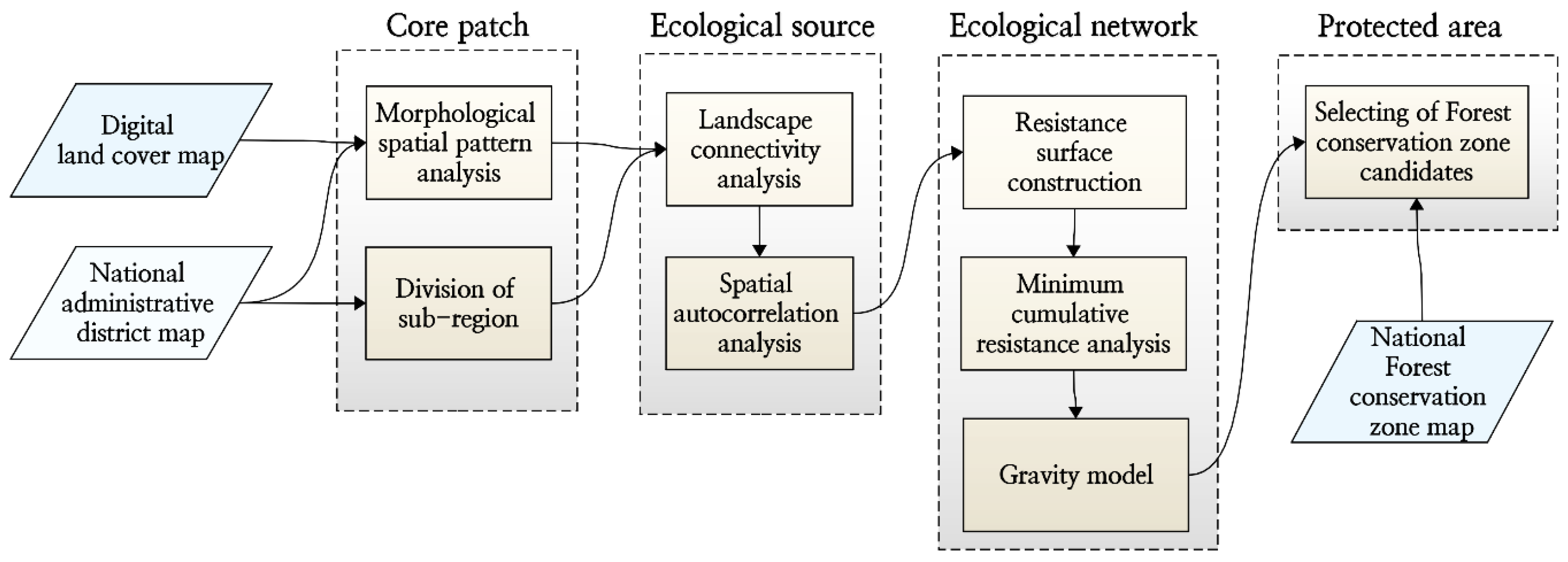
2. Materials and Methods
2.1. Study Area
2.2. Identification of Ecological Sources
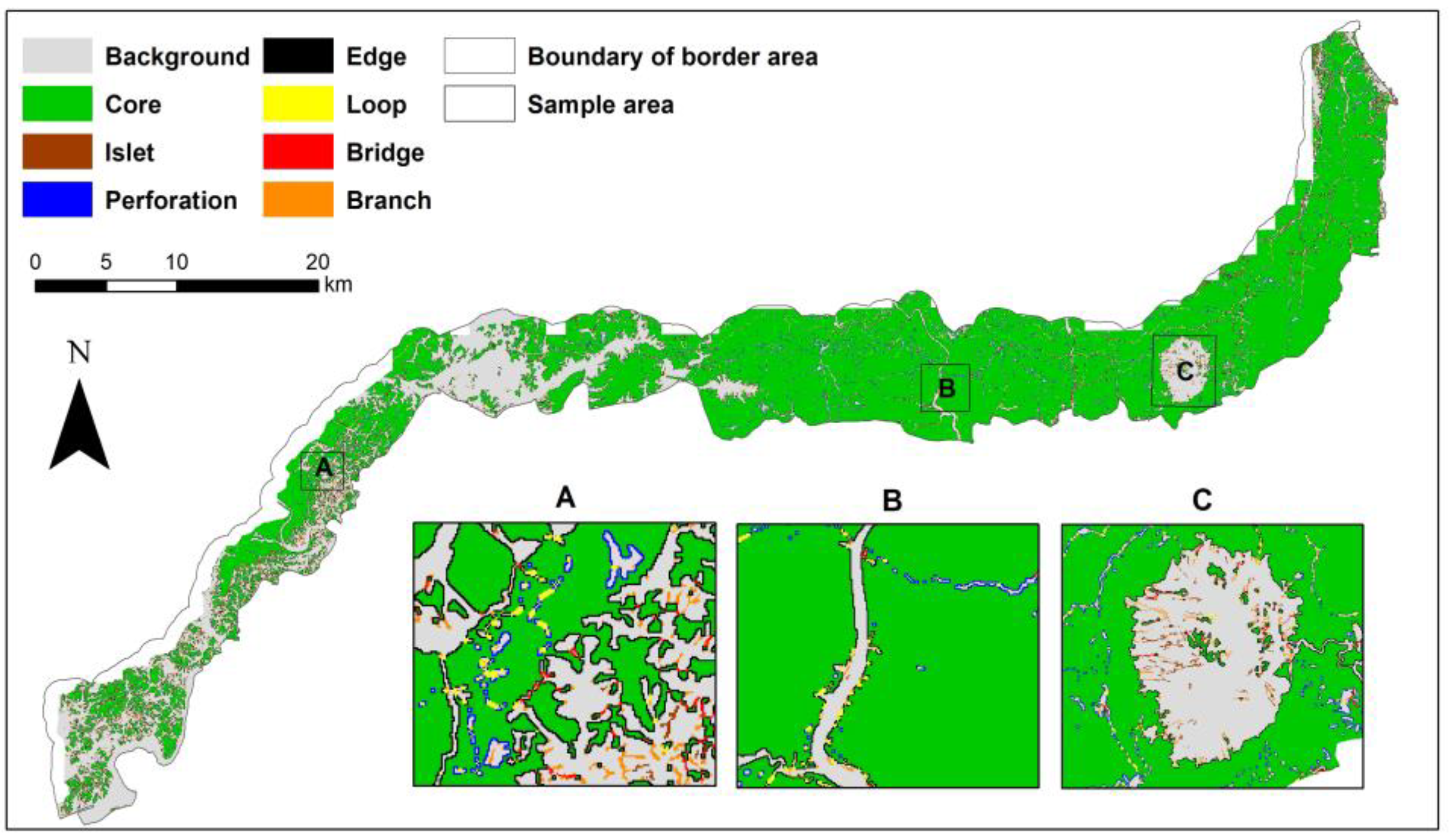
2.2.1. Morphological Spatial Pattern Analysis (MSPA)
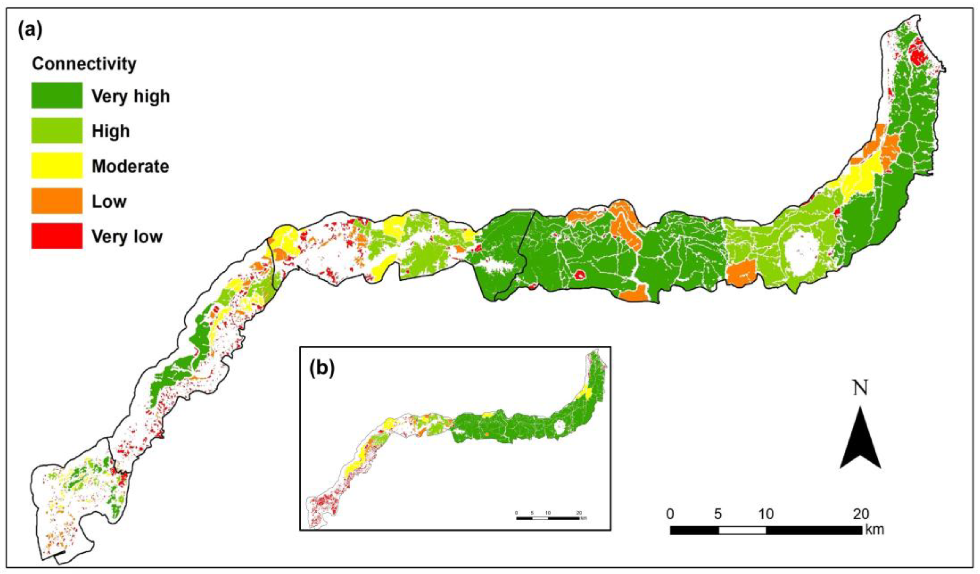
2.2.2. Evaluation of Landscape Connectivity
2.3. Constructing the Ecological Network
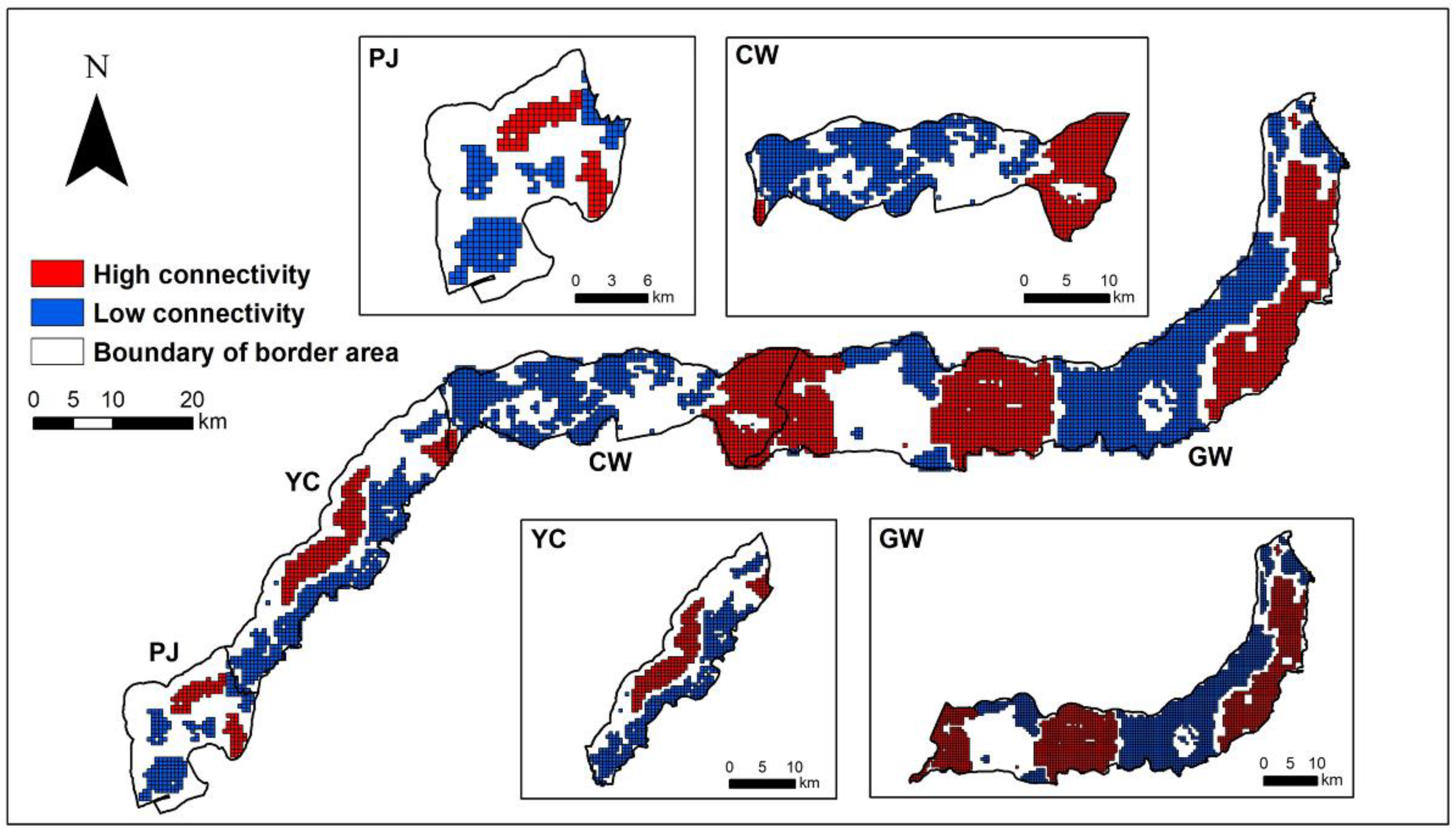
2.3.1. Area Clustering Using Spatial Autocorrelation Analysis
2.3.2. Constructing Ecological Cost and Ecological Resistance Surfaces
2.3.3. Establishing the Ecological Network and Selecting Forest Area Candidates for Protection
3. Results
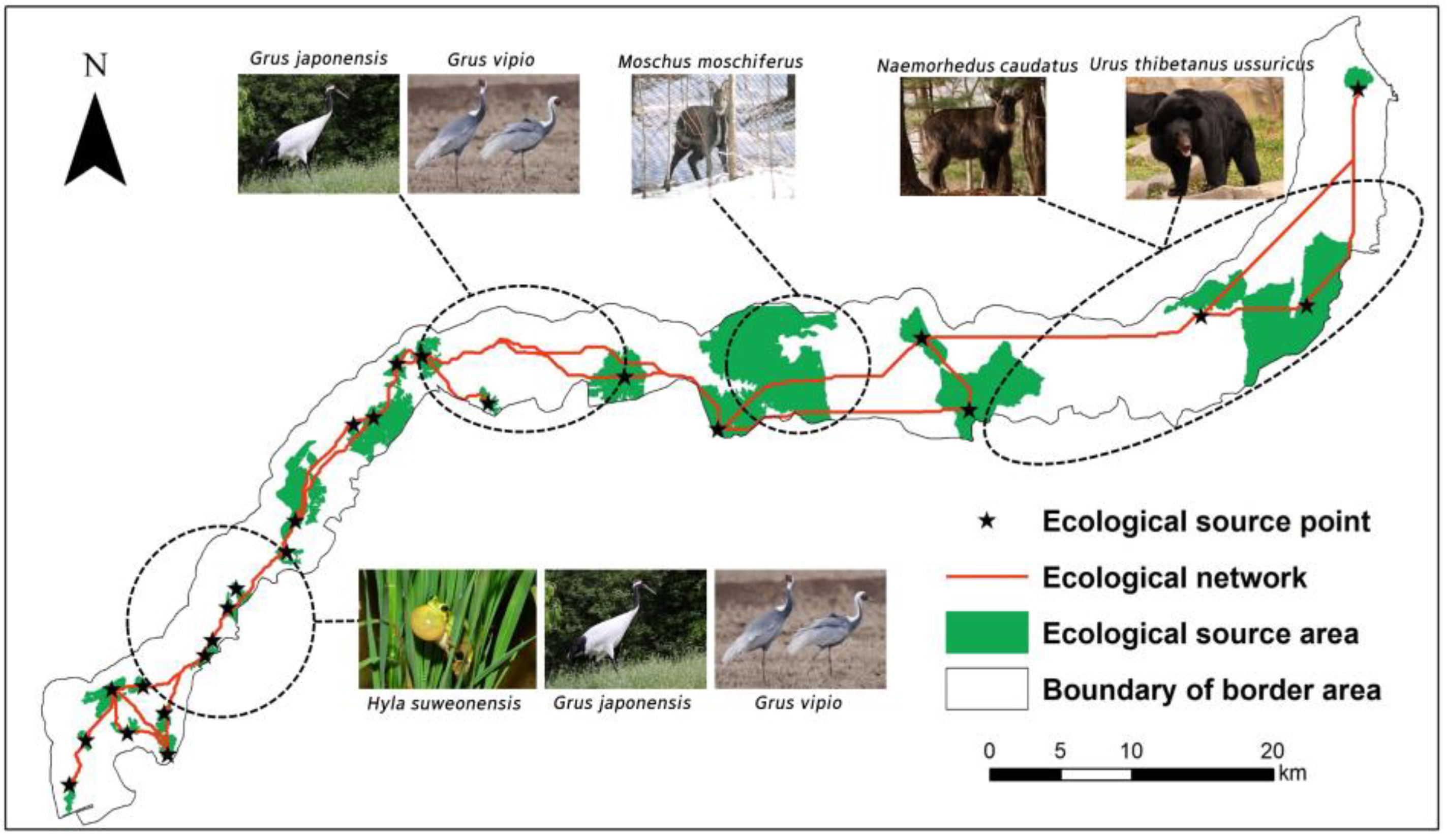
3.1. Ecological Sources
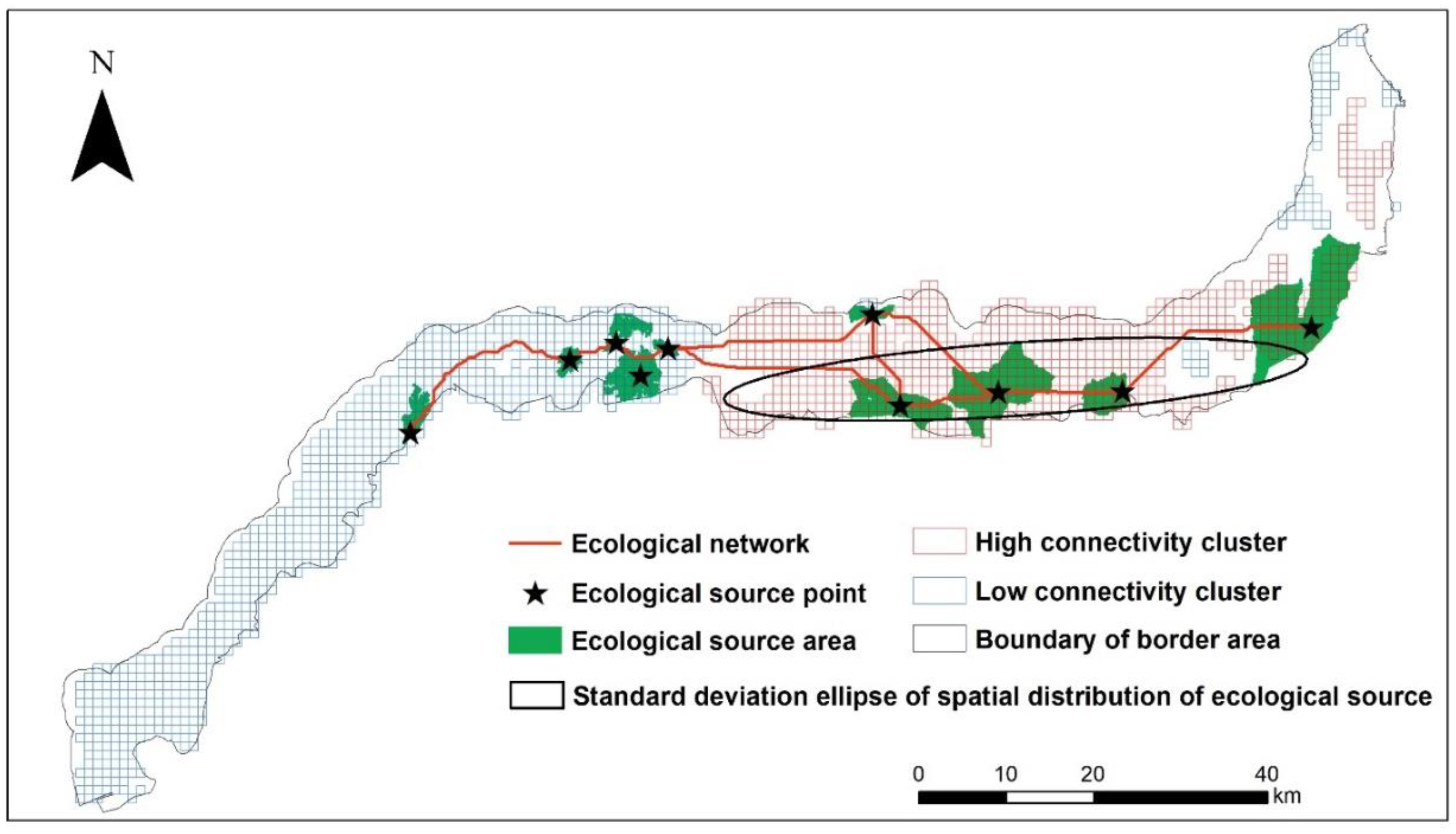
3.2. Clustering Area by Landscape Connectivity
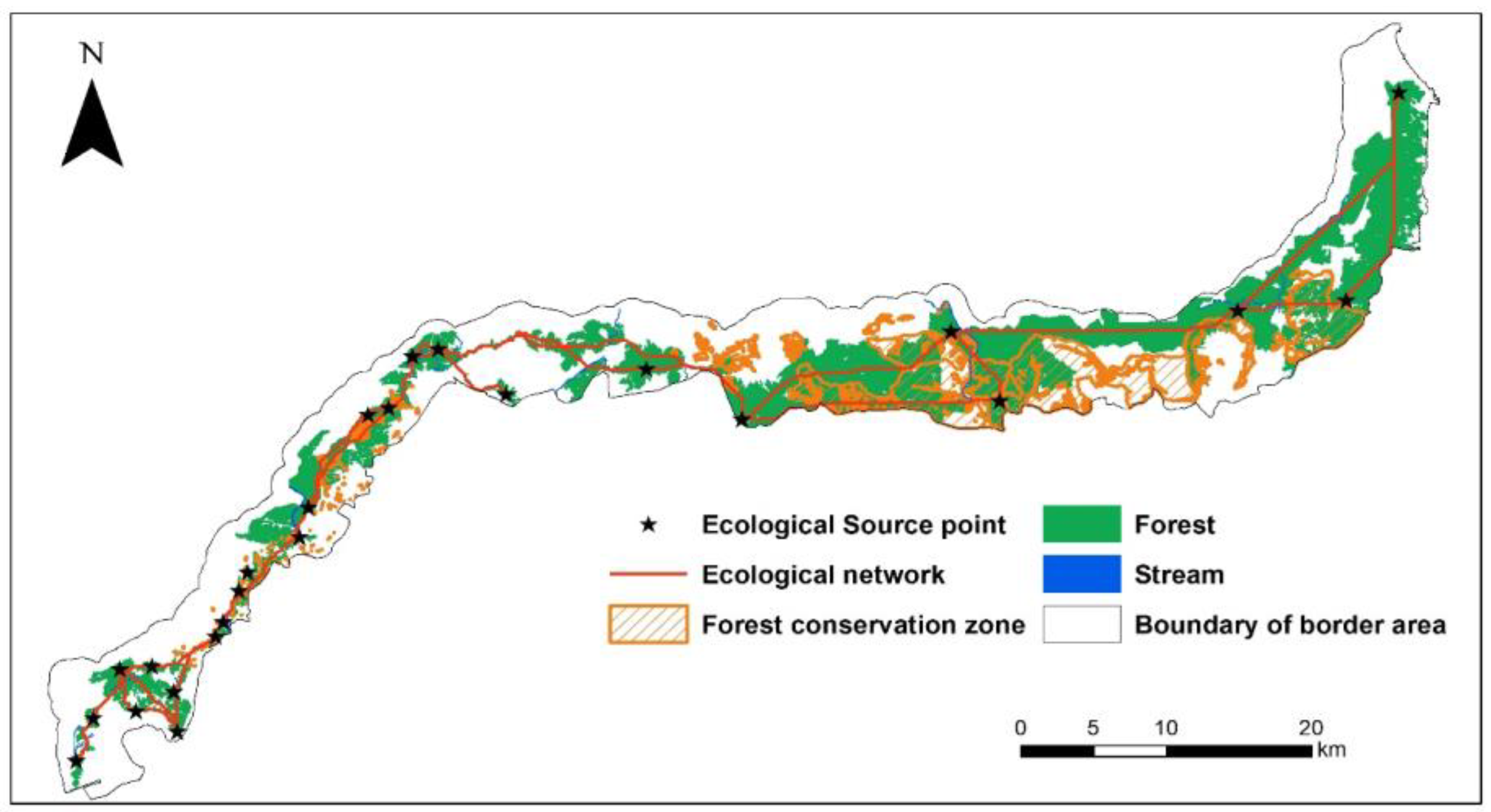
3.3. Ecological Network and Proposed Protected Area
3.4. Comparing the Results of Constructing an Ecological Network with Global Approach
4. Discussion
4.1. Constructing Effective Ecological Networks That Take into Account Terrain and Land Use Characteristics
4.2. Value of Ecological Networking in the South Korean Border Area
4.3. Establishing Protected Areas for Ecological Connectivity in the South Korean Border Area
5. Conclusions
- (1)
- Considering the macroscopic topographic characteristics of the Korean peninsula, such as a high altitude in the east and a low altitude in the west, with consequently varied land use patterns, the study area was divided into four regions. We selected the core source forest patches for each region by analyzing the forest landscape connectivity in each region. The paths drawn for constructing an ecological network were connected to reflect all paths throughout the study area. This method allowed for more effective connections throughout the area than those derived from a global analysis; hence, our method is anticipated to enhance the ecological connectivity of the entire study area.
- (2)
- A forest network spanning 452.36 km2 to connect the core source forest patches in each region effectively connects the habitats of the main endangered wildlife species inhabiting the study area. The developed network is, thus, anticipated to serve as an ecological corridor. Furthermore, to enhance forest ecosystem connectivity in the border area, it is necessary to consider forests of 564.33 km2 in the vicinity of the network paths as candidate forest conservation zones, which would contribute to achieving Target 3 outlined in the Post-2020 Global Diversity Framework.
- (3)
- The method applied in this study will prove effective for constructing ecological networks of two areas with unique land use and topographic characteristics while remaining versatile owing to its simple, intuitive, and quantitative analytical process.
- (4)
- Because this study utilized limited spatial information, only ecological functions were considered in the selection of forest reserve sites. However, it is believed that a more effective selection of reserve sites can be achieved by considering spatial information that considers the structural value of forest patches. In addition, although this study focused on establishing a method for optimal network construction, it is necessary to calculate the optimal resistance value according to the regional characteristics and the purpose of network construction when utilized for designing policy.
Funding
Data Availability Statement
Acknowledgments
Conflicts of Interest
References
- Haddad, N.M.; Brudvig, L.A.; Clobert, J.; Davies, K.F.; Gonzalez, A.; Holt, R.D.; Lovejoy, T.E.; Sexton, J.O.; Austin, M.P.; Collins, C.D.; et al. Habitat fragmentation and its lasting impact on Earth’s ecosystems. Sci. Adv. 2015, 1, e1500052. [Google Scholar] [CrossRef] [PubMed]
- Liu, J.; Wilson, M.; Hu, G.; Liu, J.; Wu, J.; Yu, M. How does habitat fragmentation affect the biodiversity and ecosystem functioning relationship? Landsc. Ecol. 2018, 33, 341–352. [Google Scholar] [CrossRef]
- Bennett, A.F.; Saunders, D.A. Habitat fragmentation and landscape change. In Conservation Biology for All; Sodhi, N.S., Ehrlich, P.R., Eds.; Oxford University Press: Oxford, UK, 2010. [Google Scholar] [CrossRef]
- Fahrig, L. Effects of habitat fragmentation on biodiversity. Annu. Rev. Ecol. Evol. Syst. 2003, 34, 487–515. [Google Scholar] [CrossRef]
- Chetcuti, J.; Kunin, W.E.; Bullock, J.M. Habitat fragmentation increases overall richness, but not of habitat-dependent species. Front. Ecol. Evol. 2020, 8, 607619. [Google Scholar]
- Zambrano, J.; Cordeiro, N.J.; Garzon-Lopez, C.; Yeager, L.; Fortunel, C.; Ndangalasi, H.J.; Beckman, N.G. Investigating the direct and indirect effects of forest fragmentation on plant functional diversity. PLoS ONE 2020, 15, e0235210. [Google Scholar] [CrossRef] [PubMed]
- Fischer, J.; Lindenmayer, D.B. Landscape modification and habitat fragmentation: A synthesis. Glob. Ecol. Biogeogr. 2007, 16, 265–280. [Google Scholar] [CrossRef]
- Wu, J. A landscape approach for sustainability science. In Sustainability Science: The Emerging Paradigm and the Urban Environment; Weinstein, M.P., Turner, R.E., Eds.; Springer: New York, NY, USA, 2012; pp. 59–77. [Google Scholar] [CrossRef]
- Korea Database of Protected Areas. Available online: http://kdpa.kr/ (accessed on 19 September 2022).
- UNEP. Aichi Biodiversity Targets. 2020. Available online: https://www.cbd.int/sp/targets/ (accessed on 8 December 2022).
- UNEP. 1st Draft of the Post-2020 Global Biodiversity Framework. UNEP—UN Environment Programme. 2021. Available online: http://www.unep.org/resources/publication/1st-draft-post-2020-global-biodiversity-framework (accessed on 8 December 2022).
- Luque, S.; Saura, S.; Fortin, M.-J. Landscape connectivity analysis for conservation: Insights from combining new methods with ecological and genetic data. Landsc. Ecol. 2012, 27, 153–157. [Google Scholar] [CrossRef]
- Forman, R.T.T.; Godron, M. Landscape Ecology; Wiley: New York, NY, USA, 1986; 648p. [Google Scholar]
- Crooks, K.R.; Sanjayan, M. Connectivity conservation: Maintaining connections for nature. In Connectivity Conservation; Crooks, K.R., Sanjayan, M., Eds.; Cambridge University Press: Cambridge, UK, 2006; pp. 1–20. [Google Scholar] [CrossRef]
- Vogt, P.; Ferrari, J.R.; Lookingbill, T.R.; Gardner, R.H.; Riitters, K.H.; Ostapowicz, K. Mapping functional connectivity. Ecol. Indic. 2009, 9, 64–71. [Google Scholar] [CrossRef]
- Fortin, M.J.; Dale, M.R.T.; Brimacombe, C. Network ecology in dynamic landscapes. Proc. Biol. Sci. 2021, 288, 20201889. [Google Scholar]
- Hellmund, P.C.; Smith, D. Designing Greenways: Sustainable Landscapes for Nature and People, 2nd ed.; Island Press: Washington, DC, USA, 2013; 288p. [Google Scholar]
- Velázquez, J.; Gutiérrez, J.; Hernando, A.; García-Abril, A. Evaluating landscape connectivity in fragmented habitats: Cantabrian capercaillie (Tetrao urogallus cantabricus) in northern Spain. For. Ecol. Manag. 2017, 389, 59–67. [Google Scholar]
- Hilty, J.; Worboys, G.L.; Keeley, A.; Woodley, S.; Lausche, B.J.; Locke, H.; Carr, M.; Pulsford, I.; Pittock, J.; White, J.W.; et al. Guidelines for Conserving Connectivity through Ecological Networks and Corridors; IUCN: Gland, Switzerland, 2020. [Google Scholar]
- Kettunen, M.; Terry, A.; Tucker, G.; Jones, A. Guidance on the Maintenance of Landscape Features of Major Importance for Wild Flora and Fauna—Guidance on the Implementation of Article 3 of the Birds Directive (79/409/EEC) and Article 10 of the Habitats Directive (92/43/EEC); Institute for European Environmental Policy (Institute for European Environmental Policy): Brussels, Belgium, 2007; 114p. [Google Scholar]
- García-Feced, C.; Saura, S.; Elena-Rosselló, R. Improving landscape connectivity in forest districts: A two-stage process for prioritizing agricultural patches for reforestation. For. Ecol. Manag. 2011, 261, 154–161. [Google Scholar] [CrossRef]
- Cantwell, M.D.; Forman, R.T.T. Landscape graphs: Ecological modeling with graph theory to detect configurations common to diverse landscapes. Landsc. Ecol. 1993, 8, 239–255. [Google Scholar] [CrossRef]
- Minor, E.S.; Urban, D.L. A graph-theory framework for evaluating landscape connectivity and conservation planning. Conserv. Biol. 2008, 22, 297–307. [Google Scholar] [CrossRef] [PubMed]
- Chen, L.; Fu, B.; Zhao, W. Source-sink landscape theory and its ecological significance. Front. Biol. China 2008, 3, 131–136. [Google Scholar] [CrossRef]
- Hansen, A. Contribution of source–sink theory to protected area science. In Sources, Sinks and Sustainability; Morzillo, A.T., Liu, J., Wiens, J.A., Hull, V., Eds.; Cambridge Studies in Landscape Ecology; Cambridge University Press: Cambridge, UK, 2011; 544p. [Google Scholar]
- McRae, B.H.; Dickson, B.G.; Keitt, T.H.; Shah, V.B. Using circuit theory to model connectivity in ecology, evolution, and conservation. Ecology 2008, 89, 2712–2724. [Google Scholar] [CrossRef] [PubMed]
- Thorne, J.H.; Choe, H.; Boynton, R.M.; Lee, D.K. Open space networks can guide urban renewal in a megacity. Environ. Res. Lett. 2020, 15, 094080. [Google Scholar] [CrossRef]
- Choe, H.; Keeley, A.T.H.; Cameron, D.R.; Gogol-Prokurat, M.; Hannah, L.; Roehrdanz, P.R.; Schloss, C.A.; Thorne, J.H. The influence of model frameworks in spatial planning of regional climate-adaptive connectivity for conservation planning. Landsc. Urban Plan. 2021, 214, 104169. [Google Scholar] [CrossRef]
- Landau, V.A.; Shah, V.B.; Anantharaman, R.; Hall, K.R. Omniscape.jl: Software to compute omnidirectional landscape connectivity. J. Open Source Softw. 2021, 6, 2829. [Google Scholar] [CrossRef]
- Boudreau, M.R.; Gantchoff, M.G.; Ramirez-Reyes, C.; Conlee, L.; Belant, J.L.; Iglay, R.B. Using habitat suitability and landscape connectivity in the spatial prioritization of public outreach and management during carnivore recolonization. J. Appl. Ecol. 2022, 59, 757–767. [Google Scholar] [CrossRef]
- Saura, S.; Torné, J. Conefor Sensinode 2.2: A software package for quantifying the importance of habitat patches for landscape connectivity. Environ. Model. Softw. 2009, 24, 135–139. [Google Scholar] [CrossRef]
- Saura, S.; Vogt, P.; Velázquez, J.; Hernando, A.; Tejera, R. Key structural forest connectors can be identified by combining landscape spatial pattern and network analyses. For. Ecol. Manag. 2011, 262, 150–160. [Google Scholar] [CrossRef]
- Wei, J.; Qian, J.; Tao, Y.; Hu, F.; Ou, W. Evaluating spatial priority of urban green infrastructure for urban sustainability in areas of rapid urbanization: A Case study of Pukou in China. Sustainability 2018, 10, 327. [Google Scholar] [CrossRef]
- Wanghe, K.; Guo, X.; Wang, M.; Zhuang, H.; Ahmad, S.; Khan, T.U.; Xiao, Y.; Luan, X.; Li, K. Gravity model toolbox: An automated and open-source ArcGIS tool to build and prioritize ecological corridors in urban landscapes. Glob. Ecol. Conserv. 2020, 22, e01012. [Google Scholar] [CrossRef]
- An, Y.; Liu, S.; Sun, Y.; Shi, F.; Beazley, R. Construction and optimization of an ecological network based on morphological spatial pattern analysis and circuit theory. Landsc. Ecol. 2021, 36, 2059–2076. [Google Scholar] [CrossRef]
- Li, Y.-Y.; Zhang, Y.-Z.; Jiang, Z.-Y.; Guo, C.-X.; Zhao, M.-Y.; Yang, Z.-G.; Guo, M.-Y.; Wu, B.-Y.; Chen, Q.-L. Integrating morphological spatial pattern analysis and the minimal cumulative resistance model to optimize urban ecological networks: A case study in Shenzhen City, China. Ecol. Process. 2021, 10, 63. [Google Scholar] [CrossRef]
- Wang, S.; Wu, M.; Hu, M.; Fan, C.; Wang, T.; Xia, B. Promoting landscape connectivity of highly urbanized area: An ecological network approach. Ecol. Indic. 2021, 125, 107487. [Google Scholar] [CrossRef]
- Jiang, J.; Abulizi, A.; Abliz, A.; Zayiti, A.; Akbar, A.; Ou, B. Construction of landscape ecological security pattern in the Zhundong region, Xinjiang, NW China. Int. J. Environ. Res. Public Health 2022, 19, 6301. [Google Scholar] [CrossRef]
- John, K.H. The Korean DMZ: A fragile ecosystem. Science 1998, 280, 803. [Google Scholar] [CrossRef]
- Kim, K.-G.; Cho, D.-G. Status and ecological resource value of the Republic of Korea’s de-militarized zone. Landsc. Ecol. Eng. 2005, 1, 3–15. [Google Scholar] [CrossRef]
- Choi, S.A.; Park, E.-J.; Park, S.-H. Conservation values of major resources in the Korean DMZ and its vicinity. Policy Res. 2010, 1, 1–216. [Google Scholar]
- Cho, D. The Ecological Values of the Korean Demilitarized Zone (DMZ) and International Natural Protected Areas. MUN HWA JAE–Annu. Rev. Cult. Herit. Stud. 2019, 52, 272–287. [Google Scholar]
- Korea Ministry of Environment; National Institute of Ecology. 5929 Species of Wildlife, Including 101 Endangered Species, Inhabit the DMZ; Korea Ministry of the Environment Press Release: Sejong-si, Republic of Korea, 2010.
- Korea Ministry of Environment. Construction of Current Land Use Map in 2020 (No. KME-11-1480000-001737-01); Ministry of the Environment: Sejong-si, Republic of Korea, 2020; 138p.
- GuidosToolbox Software. Available online: https://forest.jrc.ec.europa.eu/en/activities/lpa/gtb/ (accessed on 19 March 2022).
- Conefor 2.6 Software. Available online: http://conefor.org (accessed on 23 May 2022).
- Hu, C.; Wang, Z.; Wang, Y.; Sun, D.; Zhang, J. Combining MSPA-MCR model to evaluate the Ecological Network in Wuhan, China. Land 2022, 11, 213. [Google Scholar]
- Saura, S.; Rubio, L. A common currency for the different ways in which patches and links can contribute to habitat availability and connectivity in the landscape. Ecography 2010, 33, 523–537. [Google Scholar]
- Liu, W.; Hughes, A.C.; Bai, Y.; Li, Z.; Mei, C.; Ma, Y. Using landscape connectivity tools to identify conservation priorities in forested areas and potential restoration priorities in rubber plantation in Xishuangbanna, Southwest China. Landsc. Ecol. 2020, 35, 389–402. [Google Scholar]
- Anselin, L. Local indicators of spatial association—LISA. Geogr. Anal. 1995, 27, 93–115. [Google Scholar]
- GeoDa Software. Available online: http://geodacenter.github.io (accessed on 23 May 2022).
- Martinho, V.J.P.D. Forest fires across Portuguese municipalities: Zones of similar incidence, interactions and benchmarks. Environ. Ecol. Stat. 2018, 25, 405–428. [Google Scholar]
- Alvarado-Serrano, D.F.; Hickerson, M.J. Spatially explicit summary statistics for historical population genetic inference. Methods Ecol. Evol. 2016, 7, 418–427. [Google Scholar]
- Pelletier, D.; Clark, M.; Anderson, M.G.; Rayfield, B.; Wulder, M.A.; Cardille, J.A. Applying circuit theory for corridor expansion and management at regional scales: Tiling, pinch points, and omnidirectional connectivity. PLoS ONE 2014, 9, e84135. [Google Scholar]
- Choe, H.; Thorne, J. Omnidirectional connectivity of urban open spaces provides context for local government redevelopment plans. Landsc. Ecol. Eng. 2019, 15, 245–251. [Google Scholar] [CrossRef]
- Knaapen, J.P.; Scheffer, M.; Harms, B. Estimating habitat isolation in landscape planning. Landsc. Urban Plan. 1992, 23, 1–16. [Google Scholar] [CrossRef]
- Su, Y.; Chen, X.; Liao, J.; Zhang, H.; Wang, C.; Ye, Y.; Wang, Y. Modeling the optimal ecological security pattern for guiding the urban constructed land expansions. Urban For. Urban Green. 2016, 19, 35–46. [Google Scholar] [CrossRef]
- Gravity Model Tool of the ArcGIS 10.7 Software. Available online: https://github.com/wanghekunyuan/Gravity-model-toolbox (accessed on 25 May 2022).
- Jiang, H.; Peng, J.; Zhao, Y.; Xu, D.; Dong, J. Zoning for Ecosystem Restoration Based on Ecological Network in Mountainous Region. Ecol. Indic. 2022, 142, 109138. [Google Scholar] [CrossRef]
- Xiao, H.; Guo, Y.; Wang, Y.; Xu, Y.; Liu, D. Evaluation and Construction of Regional Ecological Network Based on Multi-Objective Optimization: A Perspective of Mountains–Rivers–Forests–Farmlands–Lakes–Grasslands Life Community Concept in China. Appl. Sci. 2022, 12, 9600. [Google Scholar] [CrossRef]
- Bae, M.G. A study on environmental conservation plan based on spatialization method in local governments. Environ. Policy 2017, 25, 25–60. [Google Scholar]
- Kim, J.H.; Park, S.; Kim, S.H.; Lee, E.J. Long-term land cover changes in the western part of the Korean demilitarized zone. Land 2021, 10, 708. [Google Scholar] [CrossRef]
- Jung, G.; Han, M.; Kang, I.; Jeon, W. Humanistic Research on the Current Non-peace State of the Border Region at DMZ; Korea Institute for National Unification: Seoul, Republic of Korea, 2020; pp. 35–37. [Google Scholar]
- Urgenson, L.S.; Nelson, C.R.; Haugo, R.D.; Halpern, C.B.; Bakker, J.D.; Ryan, C.M.; Waltz, A.E.M.; Belote, R.T.; Alvarado, E. Social perspectives on the use of reference conditions in restoration of fire-adapted forest landscapes. Restor. Ecol. 2018, 26, 987–996. [Google Scholar] [CrossRef]
- Harvey, E.; Gounand, I.; Ward, C.L.; Altermatt, F. Bridging ecology and conservation: From ecological networks to ecosystem function. J. Appl. Ecol. 2017, 54, 371–379. [Google Scholar] [CrossRef]
- Guimarães, P.R. The structure of ecological networks across levels of organization. Annu. Rev. Ecol. Evol. Syst. 2020, 51, 433–460. [Google Scholar] [CrossRef]
- Jin, Y.; Jeong, S.; Jeong, S.; Lee, D. Assessment on the forest conservation value considering forest ecosystem services—The case of Gapyung-gun. J. Environ. Impact Assess. 2015, 24, 420–431. [Google Scholar] [CrossRef]
- Mikusiński, G.; Orlikowska, E.H.; Bubnicki, J.W.; Jonsson, B.G.; Svensson, J. Strengthening the network of high conservation value forests in Boreal landscapes. Front. Ecol. Evol. 2021, 8, 595730. [Google Scholar] [CrossRef]
- Munteanu, C.; Senf, C.; Nita, M.D.; Sabatini, F.M.; Oeser, J.; Seidl, R.; Kuemmerle, T. Using historical spy satellite photographs and recent remote sensing data to identify high-conservation-value forests. Conserv. Biol. 2022, 36, e13820. [Google Scholar]
- Kim, G.H.; Kong, S.J.; Kim, O.S.; Son, S.W.; Lee, E.J. A strategy on extracting terrestrial protected areas of the Republic of Korea under the convention on biological diversity. J. Assoc. Korean Geogr. 2017, 6, 407–423. [Google Scholar]
- National Index of South Korea. Available online: http://www.index.go.kr/potal/ (accessed on 19 September 2022).
- Hong, J.-P.; Shim, Y.-J.; Heo, H.-Y. A study on Aichi biodiversity target 11—Focused on quantitative expansion goals and qualitative improvement goals of protected areas. J. Korean Soc. Environ. Restor. Technol. 2017, 20, 43–58. [Google Scholar]
- Niebuhr, B.B.S.; Wosniack, M.E.; Santos, M.C.; Raposo, E.P.; Viswanathan, G.M.; da Luz, M.G.E.; Pie, M.R. Survival in patchy landscapes: The interplay between dispersal, habitat loss and fragmentation. Sci. Rep. 2015, 5, 11898. [Google Scholar]
- Choi, J.S.; Jin, J.H.; Shim, W.J.; An, Y.S.; Shin, H.S.; Lee, S.J.; Park, S.J. A study on the development of topographical variables and algorithm for mountain classification. J. Korean Geomorphol. Assoc. 2018, 25, 1–18. [Google Scholar]


| Land Use Class | Area (Percentage) | ||||
|---|---|---|---|---|---|
| PJ | YC | CW | GW | Total | |
| Developed area | 4.66 (2.27) | 3.98 (1.18) | 7.47 (1.82) | 8.59 (0.81) | 24.69 (1.23) |
| Agricultural area | 44.19 (21.55) | 39.50 (11.76) | 73.93 (18) | 24.89 (2.35) | 182.50 (9.08) |
| Forest | 73.34 (35.77) | 163.27 (48.59) | 250.77 (61.07) | 938.76 (88.72) | 1426.14 (70.96) |
| Grassland | 22.24 (10.85) | 38.91 (11.58) | 47.20 (11.50) | 25.18 (2.38) | 133.54 (6.64) |
| Wetland | 5.93 (2.89) | 2.75 (0.82) | 9.82 (2.39) | 7.67 (0.72) | 26.17 (1.30) |
| Bare ground | 6.50 (3.17) | 3.54 (1.05) | 3.14 (0.76) | 11.13 (1.05) | 24.30 (1.21) |
| Water | 12.73 (6.21) | 3.70 (1.10) | 6.62 (1.61) | 4.99 (0.47) | 28.05 (1.40) |
| Non-investigated | 35.45 (17.29) | 80.34 (23.91) | 11.67 (2.84) | 36.92 (3.49) | 164.38 (8.18) |
| Total | 205.03 (100) | 336.00 (100) | 410.61 (100) | 1058.13 (100) | 2009.77 (100) |
| Land Use Class | Weight | Suitability | Cost | Resistance |
|---|---|---|---|---|
| Developed area | 0.05 | 100 | 95 | 100 |
| Agricultural area | 0.25 | 60 | 85 | 30 |
| Forest | 0.66 | 100 | 34 | 0.1 |
| Grassland | 0.3 | 80 | 76 | 0.5 |
| Wetland | 0.25 | 60 | 85 | 1 |
| Bare ground | 0.2 | 50 | 90 | 10 |
| Water | 0.1 | 10 | 99 | 1 |
| MSPA Class | Area (Percentage) | ||||
|---|---|---|---|---|---|
| PJ | YC | CW | GW | Total | |
| Background | 131.69 (64.23) | 172.77 (51.42) | 159.98 (38.96) | 119.78 (11.32) | 584.23 (29.07) |
| Core | 45.39 (22.14) | 120.21 (35.78) | 217.84 (53.05) | 864.09 (81.66) | 1247.54 (62.07) |
| Islet | 0.45 (0.22) | 0.80 (0.24) | 0.30 (0.07) | 0.85 (0.08) | 2.40 (0.12) |
| Bridge | 0.42 (0.20) | 1.90 (0.57) | 4.76 (1.16) | 24.20 (2.29) | 31.28 (1.56) |
| Edge | 19.37 (9.44) | 28.41 (8.46) | 20.02 (4.88) | 27.61 (2.61) | 95.41 (4.75) |
| Loop | 1.10 (0.54) | 2.35 (0.70) | 3.45 (0.84) | 13.63 (1.29) | 20.54 (1.02) |
| Perforation | 2.90 (1.41) | 3.74 (1.11) | 1.67 (0.41) | 4.10 (0.39) | 12.41 (0.62) |
| Branch | 3.72 (1.81) | 5.81 (1.73) | 2.59 (0.63) | 3.85 (0.36) | 15.97 (0.79) |
| Total | 205.03 (100) | 336.00 (100) | 410.61 (100) | 1058.13 (100) | 2009.77 (100) |
| Region | Count | Area (km2) | Connectivity (dPC) | ||||
|---|---|---|---|---|---|---|---|
| Aver. | Max. | Std. | Aver. | Max. | Std. | ||
| PJ | 529 | 0.05 | 2.04 | 0.19 | 0.47 | 18.91 | 1.89 |
| YC | 692 | 0.14 | 20.72 | 1.18 | 0.34 | 53.16 | 3.02 |
| CW | 400 | 0.72 | 140.12 | 7.30 | 0.54 | 78.42 | 4.41 |
| GW | 437 | 1.92 | 220.85 | 16.91 | 0.49 | 59.10 | 4.30 |
| Total | 2058 | 0.71 | 220.85 | 8.93 | 0.45 | 78.42 | 2.16 |
| Species Name (Scientific) | GDEW | IUCN | CITES | GDRL | Major Habitat Type | Major Behavior |
|---|---|---|---|---|---|---|
| Moschus moschiferus | Class I | VU | Appendix II | CR | Forest area, Mountainous region | Seasonal movement; Altitudinal migration |
| Hyla suweonensis | Class I | EN | - | EN | Wetland, Aquatic vegetation area | Breeding behavior; Egg laying on rice paddy |
| Grus japonensis | Class I | EN | Appendix I | EN | Wetland | Feeding behavior; Foraging in rice paddy and field |
| Grus vipio | Class II | VU | Appendix I | NT | Wetland | Feeding behavior;Foraging in rice paddy and field |
| Ursus thibetanus ussuricus | Class I | VU | Appendix I | EN | Forest area | Territoriality; Wide homeranges with seasonal variations |
| Naemorhedus caudatus | Class I | VU | Appendix I | VU | Forest area, Mounatinous terrain | Movement; Agile climbers, adapted for steep and rugged terrain |
Disclaimer/Publisher’s Note: The statements, opinions and data contained in all publications are solely those of the individual author(s) and contributor(s) and not of MDPI and/or the editor(s). MDPI and/or the editor(s) disclaim responsibility for any injury to people or property resulting from any ideas, methods, instructions or products referred to in the content. |
© 2024 by the author. Licensee MDPI, Basel, Switzerland. This article is an open access article distributed under the terms and conditions of the Creative Commons Attribution (CC BY) license (https://creativecommons.org/licenses/by/4.0/).
Share and Cite
Lim, C.H. Establishing an Ecological Network to Enhance Forest Connectivity in South Korea’s Demilitarized Zone. Land 2024, 13, 106. https://doi.org/10.3390/land13010106
Lim CH. Establishing an Ecological Network to Enhance Forest Connectivity in South Korea’s Demilitarized Zone. Land. 2024; 13(1):106. https://doi.org/10.3390/land13010106
Chicago/Turabian StyleLim, Chi Hong. 2024. "Establishing an Ecological Network to Enhance Forest Connectivity in South Korea’s Demilitarized Zone" Land 13, no. 1: 106. https://doi.org/10.3390/land13010106
APA StyleLim, C. H. (2024). Establishing an Ecological Network to Enhance Forest Connectivity in South Korea’s Demilitarized Zone. Land, 13(1), 106. https://doi.org/10.3390/land13010106