Article

Assessing the Influence of Water Conservancy Projects on China’s Reserve Resources for Cultivated Land

State Key Laboratory of Simulation and Regulation of Water Cycles in River Basins, China Institute of Water Resources and Hydropower Research, No.1 Yuyuantan South Street, Haidian, Beijing 100038, China
*
Authors to whom correspondence should be addressed.
Land 2023, 12(9), 1811; https://doi.org/10.3390/land12091811
Submission received: 22 August 2023 / Revised: 18 September 2023 / Accepted: 18 September 2023 / Published: 20 September 2023

Abstract

:
The development of reserve resources of cultivated land (RRCL) is a vital way of supplementing cultivated land in the northern arid and semi-arid regions of China. This study developed a suitability evaluation system for reserve resources of cultivated land from the nature–function–environment perspective. The evaluation considered the construction of water conservancy projects, establishing two scenarios of rain-fed and irrigated agriculture. The evaluation results for unused land were divided into four levels, including highly suitable, relatively suitable, moderately suitable and unsuitable, using the three-dimensional Rubik’s cube spatial classification method. The results show that: (1) Under the rain-fed agriculture scenario, the developable quantity and quality of unused land were poor. The potential area of reserve resources of cultivated land only accounted for 5% of the total area. (2) Under the irrigated agriculture scenario, the potential area of reserve resources of cultivated land increased to 21% of the total unused land. The areas were mainly distributed in Xinjiang, Inner Mongolia, and Gansu. The research considered the impact of water conservancy projects on the development and utilization of reserve resources of cultivated land. It can provide references for the development of arable land resources and territorial spatial planning in China.

1. Introduction

As an essential natural resource, cultivated land is not only responsible for agricultural production and the foundation for guaranteeing food security, but also related to promoting the stability and sustainable development of the nation [1]. Especially as the most populous country in the world, China has made “ensure the stable and adequate supply of cultivated land for food production” the primary goal to realize economic and social development as well as long-term stability [2,3]. China’s Central Document No. 1 has emphasized the importance of ensuring cultivated land for 20 consecutive years, starting from 2004 [4]. However, the existing cultivated land has faced the dilemma of a mismatch between supply and demand in recent years [5]. The area of cultivated land required for food consumption increased from 124 million hectares in 1981 to 137 million hectares in 2016, with a growth rate of 1.5% per annum [6,7]. Under the background of upgrading the dietary consumption of its citizens, China will need more cultivated land to meet the growing demand in the future. However, the quantity and quality of the existing cultivated land are developing in an unfavorable direction in China. The amount of cultivated land has been decreasing in the past decade, from 2.03 × 10⁵ km2 in 2013 to 1.91 × 10⁵ km2 in 2022, with a total reduction of 6.3% [8]. The quality of cultivated land has been uneven, particularly in the northern arid and semi-arid region of China [9,10]. According to the main data results of “the national cultivated land quality evaluation” in 2015, released by the Ministry of Natural Resources of China, the area in medium- and low-yield cultivated land accounted for 60.08% of the total area [11], indicating that the current supply situation for cultivated land is not optimistic in China. Therefore, it is an urgent issue to explore how to guarantee the effective supply of cultivated land in China in the future.
Faced with increasing food demand, it is necessary that China increase the yield of cultivated land to alleviate the tight balance between food supply and demand [12]. There are two ways to increase grain yield of cultivated land, including increasing the yield per unit area of cultivated land [13] and expanding the area of cultivated land [14,15]. The use of chemical substances, such as fertilizers and pesticides, in agriculture has long been an effective measure to increase production [16]. However, unreasonable use of agrochemicals may lead to environmental problems in the regional ecosystem, such as eutrophication of water bodies and emissions of greenhouse gases [17,18]. The latest document “Action Plan for the Reduction of Chemical Fertilizers and Chemical Pesticides by 2025” has proposed further reductions in the application of chemical fertilizers and pesticides in order to avoid continued environmental pollution. The growth rates in yields of important grains have slowed in recent years. The annual growth rate in grain yield was about 1.7% from 2000 to 2010 in China, while it decreased to 1.4% from 2010 to 2021. It will be more difficult to improve production intensity per unit area of cultivated land against the background of increasing restrictions on agricultural production factors [19,20]. Therefore, expanding the area of cultivated land has become the effective measure to guarantee food security at this stage. Further, the development and utilization of reserve resources for cultivated land (RRCL) is an important strategy to expand the area of cultivated land [21,22].
At present, many studies have been conducted to evaluate the suitability of potential RRCL to be developed and utilized at home and abroad, usually involving multiple complex and interrelated factors. Aini, Lis et al. evaluated the suitability of land use in Chanklingan Street in Yogyakarta, from the aspects of natural conditions such as topography, soil, and temperature [23]. Sati Prasad Sahoo et al. carried out a suitability evaluation and zoning of land use in Dwarakeswar-Gandheswari river basin, India, taking geological, hydrological, and meteorological parameters into consideration [24]. Murad, J Sumarsono et al. constructed an evaluation system for the land on Lombok Island, from the perspective of land slope, soil depth, temperature and rainfall [25]. It has provided a reference for the selection of indicators for evaluation of the suitability of RRCL. Bedawi, Goma et al. evaluated the suitability of agricultural land based on GIS geographic data, taking Senawang, Mambau, Sandakan and Rakan in Malaysia as examples. They mainly considered ecological factors to analyze the potential risk of environmental degradation that may be caused by RRCL development [26]. In summary, most of the current evaluation studies on the suitability of RRCL development and utilization only focused on unilateral factors, while the evaluation of the development of RRCL is a complex and comprehensive problem involving natural, social, ecological, and other perspectives. However, the existing research studies have rarely considered various conditions to establish the evaluation system for RRCL.
Recently, the proportion of reserve resources for cultivated land in the northern region accounted for more than 70% of the total area in China, according to the results of the second national survey and evaluation of reserve resources for cultivated land. In particular, the arid and semi-arid areas, with few people and substantial land reserves, have become an important area of RRCL in the national food development program [27]. Therefore, the efficient utilization of RRCL in the northern region has become a key issue that needs to be given attention in China [28]. However, the northern region is the region with the poorest water resources endowment, representing the most prominent contradiction between supply of and demand for water resources in China [29]. The total amount of precipitation and water resources , in the northern region only accounted for 32% and 25% of the totals for the country, respectively, in 2021. Water resources are the most important factor limiting the production capacity of cultivated land, especially in the arid and semi-arid regions [28]. Therefore, ensuring the water supply has become the key point affecting the conditions for the development and utilization of RRCL in this region.
In order to alleviate the current mismatch between water and soil resources, the implementation of water conservancy projects and investments in irrigation in the northern region have been gradually increased. Irrigation conditions have changed, impacting the cultivated land [30,31]. Irrigation conditions can have a direct and positive impact on crop productivity, effectively mitigating the decrease in production caused by high temperature and drought [32,33]. This effect is more obvious in the arid and semi-arid regions. Agriculture is almost completely dependent on the irrigation conditions in these regions [13]. In the arid and semi-arid areas of northern China, irrigated agriculture possesses the advantages of lower interannual fluctuation and higher production stability, compared with rain-fed agriculture [34]. Therefore, improved conditions for irrigation are beneficial to the improvement of agricultural production in northern China. However, although the existing research studies have proved the important and positive impact of irrigation conditions, current evaluations of RRCL development have not considered the limitations posed by water shortages [22,31,35,36]; consequently the key factor of irrigation conditions is often ignored in the evaluation system.
This study considered the irrigation conditions including the built, under-construction and planned water conservancy projects of large and medium size in the north region of China and constructed an evaluation index system to evaluate the RRCL from the perspective of nature–function–environment quality. This study constructed two scenarios, namely rain-fed and irrigated agriculture, which were evaluated, respectively. The unused land in the northern region of China was used as an example to explore the application of the evaluation of RRCL. Using the three-dimensional Rubik’s cube spatial classification method, we obtained potential zoning results that could eventually determine a reasonable and effective zoning scheme for RRCL development. This study provides a scientific and rational reference for research on the evaluation of RRCL.

2. Materials and Methods
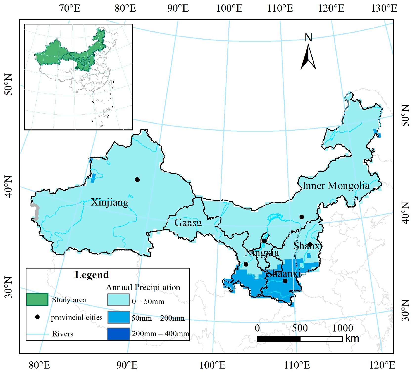
2.1. Study Area

According to the evaluation method for RRCL in the Third National Land Survey and the annual Land Change Survey in 2020, four types of land, including grassland, saline-alkali land, sandy land, and bare land, were selected as the evaluation objects in this study. According to the evaluation results of the second national survey and evaluation of reserve resources for cultivated land, 70% of the RRCL are mainly distributed in the northern region, especially in the arid and semi-arid areas [27]. Considering the small area and fragmented distribution of RRCL in mountainous areas, this study selected the arid and semi-arid regions of northern China, excluding the mountainous region, as the study area, including Shaanxi Province, Gansu Province, Ningxia Hui Autonomous Region, Shanxi Province. Xinjiang Uygur Autonomous Region and Inner Mongolia Autonomous Region (Figure 1). The study area covers a land area of about 3.73 × 10⁶ km2, accounting for about 39% of the country, the cultivated land area accounting for about 16% of the total cultivated land in the country, and the grain output accounting for about 15% of the country’s total. The total water resources in the study area only accounted for 10.5% of the total water resources in the country, and the annual precipitation of 459.2 mm only reached 66.4% of the national average of 691.6 mm in 2021. Limitations or lack of water made it difficult to realize a high level of agricultural production capacity on existing cultivated land in the study area; consequently, it needs irrigation support.

2.2. Comprehensive Evaluation System for Potential RRCL

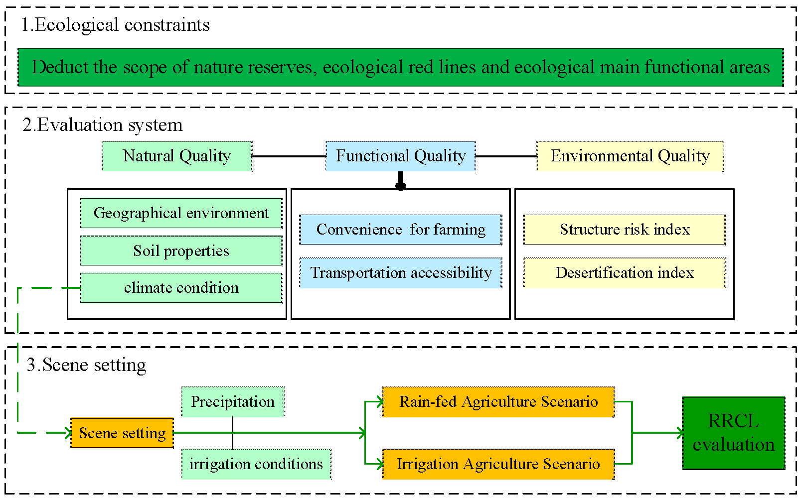
2.2.1. Construction of a Theoretical Framework for Evaluations

Evaluating the development potential of RRCL is a complex and comprehensive process that should be based on multiple perspectives, such as nature, function and environment, to establish a theoretical framework for scientific evaluations of development potential [37]. The multifactor comprehensive evaluation method (MCE) used in this study is the most commonly used suitability evaluation method [31] combining qualitative and quantitative methods. It has the advantage of integrating multiple factors and evaluation criteria to provide better spatial decision-making [38], which is conducive to solving decision-making problems that depend on multiple factors, such as evaluating the suitability of land use.
The rational development of RRCL first needs to meet ecological constraints. The study area is rich in land resources, including various types of unused land. However, many places in the northern region have been natural concentrated distribution areas for a variety of rare and endangered species since ancient times, with many wild plants and animals [39] that should be under special protection and management in China’s regulations for nature reserves. Therefore, in the evaluation of RRCL, it is necessary to exclude these nature reserves, such as the Kanas Comprehensive Natural Landscape Reserve in Xinjiang, the Saihan Wula National Nature Reserve in Inner Mongolia, and other key nature reserves. At the same time, there are also many areas facing practical problems such as fragile ecological environments and poor protection [40], delineated as ecological red zones in the “Opinions of the State Council on Strengthening the Key Work of Environmental Protection”, and thus need to be excluded from the development of RRCL. Additionally, areas with functions for water conservation, soil and water conservation, windbreaks, and sand fixation, as well as the maintenance of biodiversity in the study area [41], which are delineated as key ecologic function areas in the “National Main Functional Area Plan”, also need to be excluded, so as to ensure that the development of RRCL will not adversely affect the ecological environment.
In evaluating the suitability of lands for RRCL development, it is necessary to consider whether three types of quality of potential RRCL, including natural quality, functional quality, and environmental quality, are suitable for development. Evaluations of suitability based on natural quality are the basic premise for selecting RRCL [42] and include the analysis of light, temperature, water, soil, and other elements that can reflect the geographical spatial distribution of unused land. In general, existing research mainly considered the geographical environment, soil properties, climate conditions and other factors [1,31,35], and determined a number of evaluation indexes such as those for topography, soil, water and heat conditions [19,28,30,43]. With the development and progress of society, evaluations of the development potential of RRCL can no longer include only the traditional focus on natural conditions, but also need to take into account factors such as socio-economic development, since these factors also have a positive impact on improving cultivated land production [44].
On the one hand, suitability evaluations of the functional quality of RRCL consider the functions that the RRCL need. Existing research on the evaluation of functional quality of land and cultivated land have considered the needs for convenience of cultivation and traffic accessibility of agriculture [45]. The closer the RRCL are to roads, towns, and water bodies, the greater their potential for development [46], which will be beneficial in terms of increasing the convenience of cultivation for cultivated lands in the future. Therefore, the distance between the land and surrounding roads, villages, etc. was selected as an evaluation index [47,48].
On the other hand, suitability evaluations also examine environmental quality. Efforts to develop and utilize RRCL need to consider their impact on the stability of the ecological environment of the region, to avoid the ecological risks and desertification arising from the conversion of land use types and ensure the stable potential of RRCL for future development. Factors such as ecological risk and desertification degree were selected as evaluation indexes with reference to existing research on the evaluation of the health of cultivated land [49,50]. The evaluation indexes and their specific meanings for RRCL in the study area are shown in Table 1.
It is the supply of water resources that is the most important constraint for the development and utilization of RRCL, especially in the arid and semi-arid regions [51]. Therefore, the local water resource constraints should be considered in the evaluation of RRCL in the study area, and it is necessary to consider the increase in water conservancy projects that result in the mitigation of water supply problems and have a positive effect on rain-fed agriculture [27]. Based on this situation, two scenarios were designed in the evaluation. One was the rain-fed agriculture scenario, in which agricultural production of RRCL depends entirely on natural precipitation; the other was the irrigation agriculture scenario, in which the artificial irrigation water provided by the water conservancy project is used as the main water source for agricultural production. The impact of water conservancy projects, such as reservoirs and water diversion projects that have been built, are under construction, or planned, on the development potential of RRCL was expressed by adding the index of irrigation water conditions into the climate condition [31]. In summary, the theoretical framework proposed in this paper for evaluations of RRCL development potential is shown in Figure 2. The comprehensive evaluation index system for RRCL quality with classification and corresponding weights of indexes is shown in Appendix A.

2.2.2. Computation of RRCL Evaluation Indexes

(1)
Standardization process for the evaluation indexes
It was necessary to develop a standardization process for each evaluation index in order to compare and weight the indexes with different units and scales. The extremum method was applied to standardize the original data of the evaluation indexes [36]. The computational formula is in Equation (1):
A i j = A i j m i n ( A j ) max A j m i n ( A j )   ( i = 1 , 2 , m ;   j = 1 , 2 , n ) ,
where: A i j represents the value of the index A i j after standardization; m a x ( A j ) indicates the maximum value of the j -th index, and m i n ( A j ) represents the minimum value of the j -th index.
(2)
Determination of weights for the indicators
In terms of evaluation indicators and their weights, prior knowledge of the literature and expert experience are important for the selection of indicators and determination of their weights [37]. The Delphi method and analytic hierarchy process commonly used in previous studies are typical applications of traditional expert systems. However, these methods are often criticized for being more subjective. Therefore, based on expert consultations, the weight of each index was calculated by the entropy weight method in this study. On the one hand, this method can reduce the interference of subjective factors. On the other hand, it can reflect the weight of each evaluation index realistically, avoiding inconsistencies between the weight and the actual importance of the index. The main calculation process for the comprehensive weight W j determined by the entropy weight method is as follows.
E j = 1 l n ( n ) j = 1 n A i j l n A i j ,
w j = 1 E j n j = 1 n E j ,
where: A i j is the value of the j -th index of the i -th sample ( i = 1, 2, …, m ; j = 1, 2, …, n ), m is the number of samples, n is the number of indicators, A i j is the standardized index value, E j is the information entropy of the j th group of indexes, and w j is the weight of the j th group of indexes.
(3)
Comprehensive evaluation model
Based on the multi-factor evaluation classification results and weights [14], the weighted index sum method was used to obtain the comprehensive evaluation results of each dimension for the evaluation of RRCL development suitability, and the comprehensive evaluation score was calculated using the following equation:
S j = i = 1 n ( A i j · w j ) ,
The higher the comprehensive quality score of the evaluation object, the better the quality. In the formula, S j is the comprehensive quality score of evaluation unit j ; A i j is the standardized score of the i th evaluation index of the evaluation unit j ; w j is the weight of the j th evaluation index based on the entropy weight method; and n is the total number of evaluation indexes.

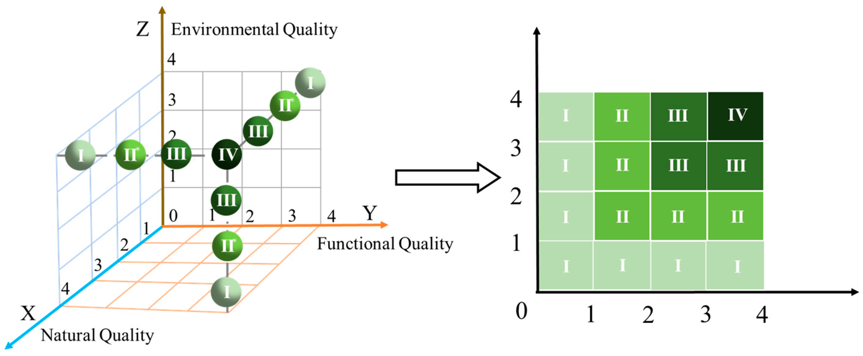
2.3. Zoning of RRCL with Different Development Potential

The three-dimensional Rubik’s cube spatial classification method was used to divide RRCL into different potential levels. According to the principle of the three-dimensional Rubik’s cube spatial classification method, the three evaluation dimensions of natural, functional, and environmental quality were set as the X-axis, Y-axis, and Z-axis of the three-dimensional Rubik’s cube, respectively, to construct a three-dimensional Rubik’s cube concept model of development potential zoning (Figure 3). Based on the comprehensive evaluation results for each dimension, the three dimensions were divided into four levels, from high to low, of 1, 2, 3, 4 using the natural breakpoint method, as the coordinate value of the nodes. According to the distance between the node and the origin of the three-dimensional space (0, 0, 0), the attribute value is assigned to 1~4. The larger the attribute value is, the higher the score of the dimension index is. On this basis, a 4 × 4 × 4 three-dimensional fourth-order cube was formed. According to the combination characteristics of different attributes of the evaluation dimensions, the RRCL were divided into four levels: highly suitable (Level IV), relatively suitable (Level III), moderately suitable (Level II) and unsuitable (Level I) [52]. The plots with unsuitable or moderately suitable attributes of three dimensions were not included in the potential area of RRCL. The zoning scheme for the potential area of RRCL is shown in Table 2.

2.4. Data Sources and Processing

The main sources of the evaluation index data used in this study were as follows:
(1)
Natural quality evaluation involves geographical environment data, soil data and climate data. The geographical environment data were obtained from STRM-DEM data (spatial resolution of 30 m) released by the United States’ Space Shuttle Radar Topographic Measurement Program, and four topographic and geomorphological indicators including slope, undulation, altitude, and slope direction were obtained by ArcGIS processing. The soil data were extracted from the 1:1 × 10⁴ soil database released by the Chinese Academy of Sciences (accessed on 30 September 2022), with a spatial resolution in 1 km × 1 km, to extract four indicators of soil type, sediment concentration, pH value and thickness of tillage layer. Additionally, the climate data used the light and heat data from the National Meteorological Science Data Center (http://www.resdc.cn (accessed on 31 December 2021)) and interpolated the data of 720 national meteorological stations in the northern region by the inverse distance weighting method to obtain two indicators of ≥10 °C cumulative temperature and sunshine hours. The precipitation data were obtained from the China Meteorological Background Data Set corrected by DEM in the Resource and Environmental Science and Data Center of the Chinese Academy of Sciences (http://www.resdc.cn (accessed on 9 January 2023)), and the index of annual average precipitation was obtained by the inverse distance weight method.
(2)
Functional quality evaluation involves the functions of farming and transportation. The distance from the village as well as the distance from the road were used as the evaluation indexes, respectively. ArcGIS10.7 was used to buffer the villages, roads, and water conservancy projects to obtain the distance distribution map. The results of national land use planning were the data source.
(3)
Environmental quality evaluation involves ecological risk indexes. The ecological risk index used the structural risk index and the desertification index as the evaluation indicators. The NDVI data involved were obtained from the MODIS data processed by the Remote Sensing Unit of the Institute of Agricultural Resources and Agricultural Division of the Chinese Academy of Agricultural Sciences.
(4)
The irrigation conditions mainly consider the distance from constructed reservoirs and those that are under construction or planned, water diversion projects, irrigation areas and other water conservancy projects. Additionally, a distance distribution map was obtained by using ArcGIS10.7 to buffer the water conservancy projects. The data sources for constructed water conservancy projects were mainly from the National Water Census, China Hydropower Yearbook and National Reservoir Dataset (CRD: China Reservoir Dataset), and the sources for water conservancy projects under construction and planned were the 172 major national water conservancy projects since 2014 and 150 major water conservancy projects during 2020–2022.
In order to facilitate unified analysis, all of the collected data were resampled into cells of 1 km × 1 km, numbered from north to south and from west to east by ArcGIS and Python.

3. Results

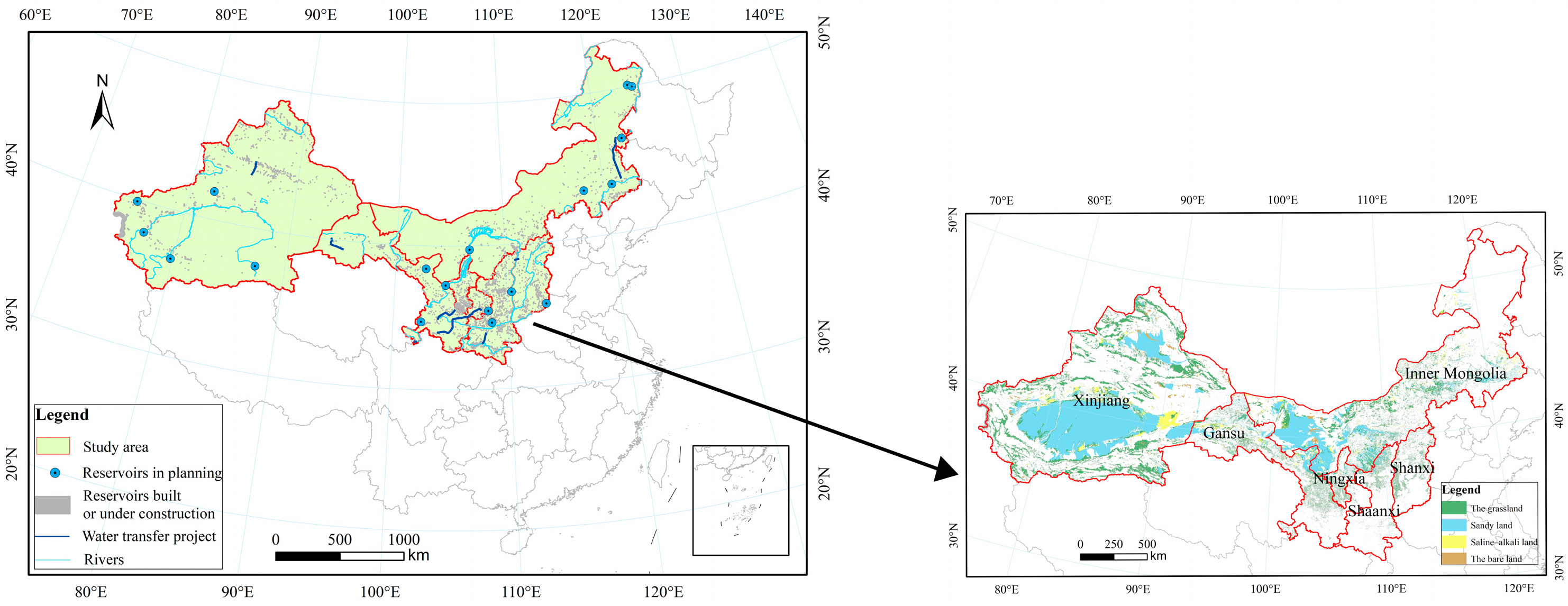
3.1. Distribution of Unused Land and Water Conservancy Projects in the Study Area

In the study area, the total area of potential reserve resources for cultivated land, including grassland, saline-alkali land, sandy land, and bare land, was 1.04 × 10⁶ km2, accounting for 28% of the total land use area in the study area. Therefore, there is still large potential for the development of RRCL in the northern arid and semi-arid regions. Among them, the area of sandy land was the largest, 5.25 × 10⁵ km2 (51%), followed by the grassland area of 4.27 × 10⁵ km2 (41%), saline-alkali land area of 5.96 × 10⁴ km2 (6%), and the remainder in bare land, of 2.55 × 10⁴ km2 (2%). The spatial distribution of potential RRCL varied in the six provinces and cities in the study area (Figure 4), mainly in Xinjiang, Inner Mongolia, and Gansu provinces, showing a dense distribution pattern in the west and a sparse distribution pattern in the east.
The arid and semi-arid areas in northern China have been long limited by the shortage of water resources, making it difficult to achieve stable development of rain-fed agriculture. So, China has planned and developed a number of water conservancy projects in order to solve the problem of drought and water shortage in the study area. Many reservoirs and water diversion projects have been built in the study area, including 3916 reservoirs, of which 74 are large reservoirs with a water supply capacity of more than 100 million m3. Eighteen large reservoirs are planned for construction in the study area. In addition, 35 water diversion projects will be planned and constructed in the region, thus allowing realization of a water diversion capacity of 16.26 billion m3 if all of the planned water conservancy projects are placed into operation in the study area in the future. The distribution of water conservancy projects in each province in the study area is shown in Figure 4.

3.2. Results of RRCL Quality Evaluations

The results of suitability evaluations of each dimension of RRCL in the northern region are as follows.

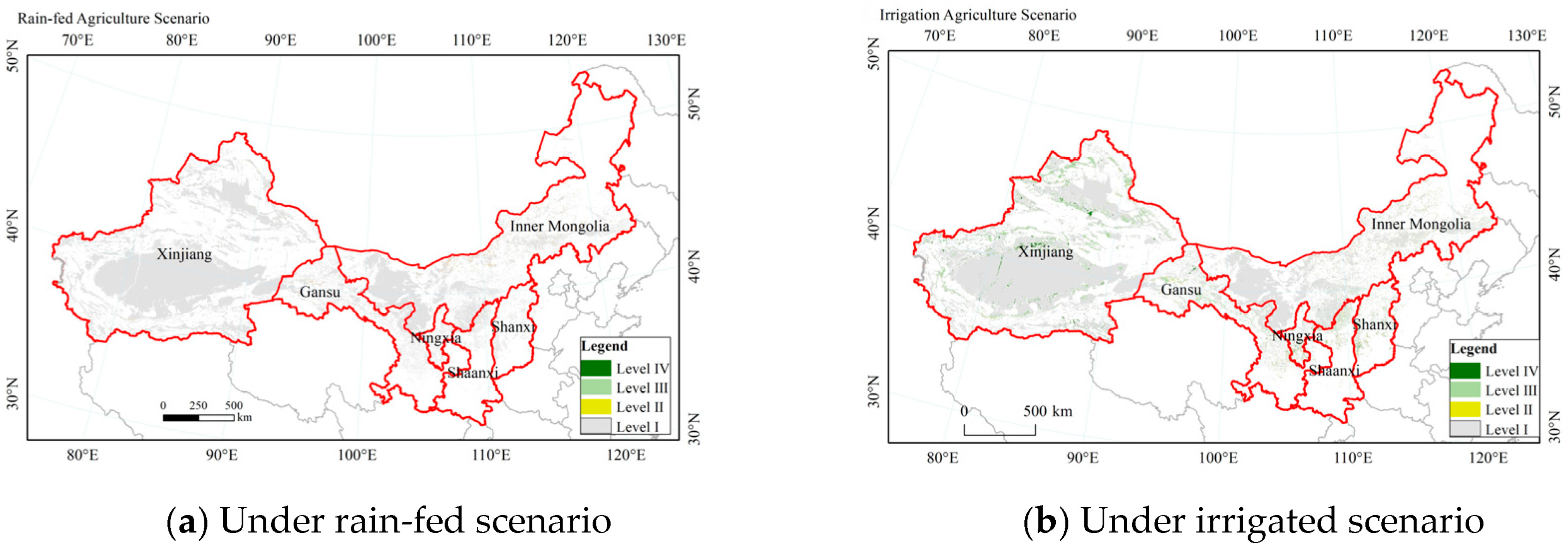
3.2.1. Natural Quality Evaluation under Rain-Fed and Irrigated Scenarios

In this study, the natural quality of RRCL was measured on the basis of geographical environment, soil properties and climate conditions. The parcels with the an evaluation result of Level 4 were the most suitable unused land for RRCL development in terms of natural quality, while the parcels with an evaluation result of Level 1 were the least suitable for development in terms of natural quality. As can be seen from Table 3, the spatial characteristics of the natural quality evaluation results were generally less suitable for development as RRCL in the six northern provinces, with most unused land placed in Level 1 by the evaluation results in terms of natural quality. Overall development suitability improved under the irrigation scenario, and the proportion of areas of Level 2–4 was obviously increased.
Under the rain-fed agriculture scenario, the evaluation results for natural quality showed that the area highly suitable for RRCL was only 0.3 × 10⁴ km2, accounting for less than 1% of the total area, spatially scattered mainly in Xinjiang and Inner Mongolia, accounting for 64% and 32%, respectively, while the area in the other four provinces was less, accounting for 4% in total. The relatively suitable area was 0.8 × 10⁴ km2, mainly distributed in Xinjiang, Inner Mongolia and Gansu, accounting for 56%, 34% and 8% of the total relatively suitable area, respectively, while it was less distributed in Ningxia, Shanxi, and Shaanxi. The moderately suitable area was mainly distributed in Xinjiang, Inner Mongolia and Gansu provinces, accounting for about 46%, 43% and 6%, respectively. The unsuitable area totaled 1.0 × 10⁶ km2, or about 96% of the total area of the study area, distributed in six provinces, of which Xinjiang accounted for the largest proportion of 61% (Figure 5a).
Under the irrigation agriculture scenario, the highly suitable area reached 4.8 × 10⁴ km2, which was much higher compared with the rain-fed agriculture scenario, mainly in Xinjiang and Inner Mongolia, accounting for 4% of the total area. Compared with the rain-fed agriculture scenario, the relatively suitable area increased by 5.9 × 10⁴ km2 to 6.7 × 10⁴ km2, mainly in Inner Mongolia, Xinjiang and Gansu, accounting for 39%, 37% and 14%, respectively. The moderately suitable areas were mainly distributed in Xinjiang and Gansu provinces. The unsuitable area totaled 9.47 × 10⁵ km2, accounting for 88% of the total area, which was obviously reduced compared with the unsuitable area under the rain-fed agriculture scenario, with Xinjiang accounting for the largest proportion, reaching 62% (Figure 5b).

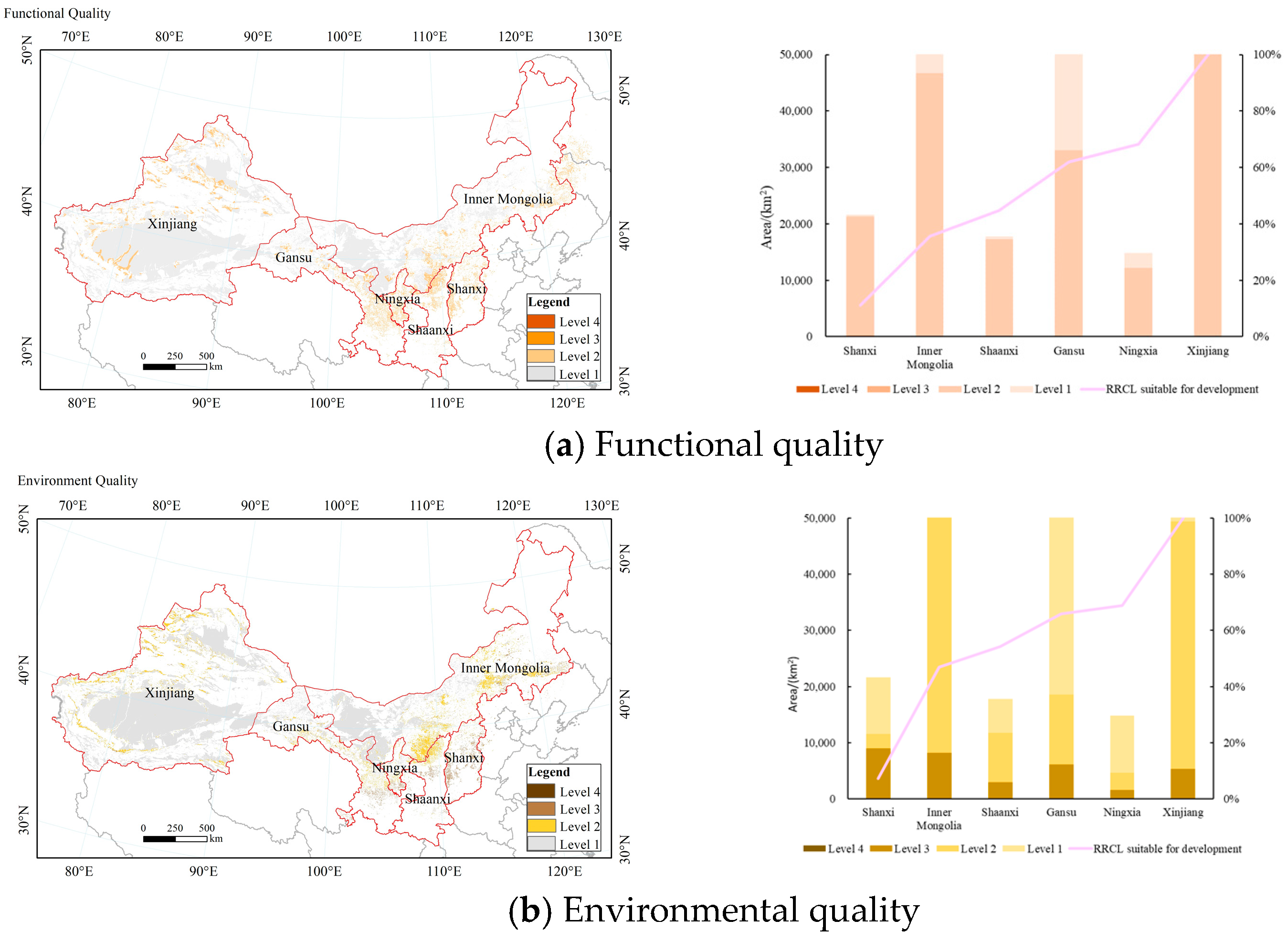
3.2.2. Functional and Environmental Quality Evaluations

In terms of the overall results of the functional quality evaluations, it can be seen from Figure 6a that the functional quality of the areas in the study area across six northern provinces were mainly unsuitable or moderately suitable. Among them, the unsuitable areas were widely distributed, with an area of 8.46 × 10⁵ km2, which accounted for more than 81% of the total area of the potential RRCL areas. The area of the moderately suitable areas measured 1.90 × 10⁵ km2, accounting for 18% of the total area, mainly distributed in western and northern Xinjiang, southern Inner Mongolia, Gansu, and Shanxi. The moderately suitable areas were widely distributed in Xinjiang and Inner Mongolia, accounting for 32% and 25% of the total in moderately suitable areas, respectively. The evaluation results show that there were fewer areas of relative or high suitability, accounting for less than 1% of the total study area, scattered in various provinces. Overall, the low level of functional quality in the six northern provinces was mainly due to the undeveloped state of the vicinity around the evaluation units, as well as the long distances from local villages and roads.
In terms of environmental quality, the evaluation results for environmental quality in Figure 6b show that areas in the study area were mainly unsuitable, moderately suitable, or relatively suitable. Among them, the area of unsuitable quality was the largest, with 8.79 × 10⁵ km2, accounting for 85% of the total area of the potential RRCL. The moderately suitable area measured about 1.25 × 10⁵ km2, accounting for 12% of the total area, mainly in northern Xinjiang, southern Inner Mongolia and central Gansu, accounting for 40%, 35% and 10% of the total in moderately suitable area, respectively. The relatively suitable area measured about 3.3 × 10⁴ km2, which was mainly distributed in Shanxi, Inner Mongolia, Gansu and Xinjiang, accounting for about 26%, 24%, 18% and 16% of the total in relatively suitable area, respectively. There were almost no areas of with a highly suitable environmental quality level in the six northern provinces, indicating that there were some limitations in the ecological environment for the development of RRCL in the northern areas.

3.3. Zoning of RRCL Quality in Six Provinces

The RRCL areas with potential for development and utilization were identified according to the evaluation results for natural, functional, and environmental quality, and the principle of assessment method of limiting factor in the six provinces of the study area, which were the areas with zoning results of Level II, III and IV, while the rest of the unused land was untillable. As can be seen from Table 4, the unused land was generally unsuitable to develop and utilize as RRCL under the rain-fed agriculture scenario in the study area, where the zoning results for potential were mainly Level I (Figure 7a), while the areas suitable for development accounted for much less of the unused land in the six northern provinces. The results show that the areas of Level I measured about 9.91 × 10⁵ km2, accounting for 96% of the total of the study area. The areas of Level I were distributed in all six provinces of the study area, and mainly in Xinjiang, which accounted for 62% of the total area of Level I since it also possesses the largest area of unused land among the six northern provinces, so the areas of Level I were less distributed in the other five provinces. However, only 4.6 × 10⁴ km2 of RRCL could be developed and utilized, including the areas of Level II, III and IV. Among them, the areas of Level II, which were the areas rated moderately suitable for development, totaled about 2.9 × 10⁴ km2, accounting for 3% of the total study area. The areas of Level II were scattered in the former area of Hetao Plain in Inner Mongolia, northern Xinjiang, Shule River in Gansu, and other places. The areas with the zoning results of Level III and IV, which were relatively and highly suitable for development as RRCL, represented the smallest proportion, accounted for an area of only 1.8 × 10⁴ km2, less than 1% of the total study area, and were sporadically distributed in Inner Mongolia and Xinjiang.
Under the scenario of irrigation agriculture, the quality of unused land has generally improved in the six northern provinces. The development potential of RRCL has been apparently increased, with a significant increase in the areas with suitable land of Level II, III and IV (Figure 7b), accounting for 2.11 × 10⁵ km2 of the total area suitable for development. Although the proportion of area with a zoning result of Level I (unsuitable for development) was still large, it was distinctly reduced by 16.7% compared with the area of Level I under the rain-fed agriculture scenario, which was reduced to 8.26 × 10⁵ km2, with the proportion of total area of the potential RRCL areas in the study area reduced to 79%. In the six provinces in the study area, improved irrigation conditions have played a positive role in the reduction of unsuitable areas for development. As for Xinjiang and Inner Mongolia, which accounted for the largest proportions of areas of Level I, the areas of Level I were reduced by 14% and 19% respectively, compared with the zoning results under the rain-fed agriculture scenario. Meanwhile, Figure 7b shows the spatial distribution of suitable land of Levels II, III and IV. The distribution of RRCL suitable for development in the study area was almost consistent with the distribution of the unsuitable areas for development, which were gradually decreasing from west to east. The area of unused land that was moderately suitable for development as RRCL increased to 6.4 × 10⁴ km2, accounting for 6% of the total in unused land, which was mainly distributed in Xinjiang, Inner Mongolia, and Gansu provinces, concentrated in Junggar Basin and Tarim Basin in Xinjiang, the former area of Hetao Plain in Inner Mongolia and the areas around Shule River in Gansu. The areas of Level III, relatively suitable for development as RRCL, increased to 9.0 × 10⁴ km2, accounting for about 9% of the total of unused land in the study area, mainly distributed along the Junggar Basin and Tarim Basin in Xinjiang. It was the areas with the potential zoning result of Level IV with unused land that was the most suitable for development and utilization as RRCL in the study area. The area of Level IV reached 5.8 × 10⁴ km2 after the improvement of irrigation conditions, accounting for 6% of the total study area and measuring 7.5 times larger than the area of Level IV under the rain-fed scenario. The areas of Level IV were distributed in all six provinces of the study area, mainly in Xinjiang (42%), Inner Mongolia (32%) and Gansu (10%), and mostly concentrated on the northern side of Tianshan Mountain and the oasis with good water and heat conditions along the Tarim River in Xinjiang, the former area of Hetao Plain in Inner Mongolia and the vicinity near the Shule River in Gansu (Figure 7b), while being less distributed in Shanxi, Ningxia, and Shaanxi (Table 4).

4. Discussion

4.1. Significant Impact on Irrigation Conditions Provided by Water Conservancy Projects in the Northern Region

Water and soil resources are the major rigid constraints affecting food security [53], especially in the study area, where abundant land resources and good soil conditions exist. However, this area has been limited by water resources such as precipitation and other factors for a long time, resulting in a lack of available water resources for agriculture, which is not conducive to guaranteeing the long-term and stable production of grain in the region [27]. Consequently, improved irrigation conditions can mitigate the limitations posed by water shortage conditions on the production capacity of cultivated land, and will play an important role in enhancing the development potential of reserve resources for cultivated land in the study area.
According to existing research, the larger the proportion of irrigated cultivated area, the higher the quality level of cultivated land, and the grain production capacity per unit area of cultivated land increased by 25% under irrigation conditions, compared with rain-fed land in the arid area of Weibei [54]. The grain yield of irrigated cultivated land is much higher than that of non-irrigated cultivated land in the northern region. And, the more arid the region, the greater the increase in yield compared with that of rain-fed land [34]. Especially in the most extensive arid and semi-arid areas in northwestern China, the contents of total soil carbon, nitrogen and phosphorus increased apparently under irrigation and fertilization conditions compared with natural desert land, while decreasing in the abandoned rain-fed land. It was found that the effective enhancement of these organic matter contents in cultivated land was most likely to have resulted from the improvement in irrigation conditions, which promote the growth of microorganisms and plants and increase carbon sequestration in the soil [55]. Therefore, irrigation conditions have played a positive and indispensable role in soil fertility, the growth of crops in the cultivated land and the environmental protection of the region.
Meanwhile, among the practical experiences of foreign countries, it has been found that Israel has a poor natural endowment of water resources, in a region of the world that typically experiences water shortages. However, it has effectively improved the yield of cultivated land under traditional rain-fed agriculture through the development of water conservancy projects nationwide, to ensure its national water security and food security [56]. Therefore, it is difficult to guarantee the production capacity of land in the absence of irrigation conditions when separated from the development of water conservancy projects, and finally, it is difficult to support the development and utilization of RRCL in the study area. However, there has been a lack of consideration for and combination of improved irrigation conditions when evaluating land or cultivated land in existing research [22,31,35,36]. Therefore, a distinctive feature of this study is that the construction of reservoirs, water transfer projects, irrigation areas and other water conservancy projects built, under construction or planned have been considered in the evaluation of the development of RRCL in the northern region. An evaluation system for the development of RRCL under two agricultural scenarios, rain-fed and irrigated agriculture, was developed based on the addition of irrigation conditions provided by water conservancy projects. It is more in line with actual conditions in China compared with the previous evaluation system. It is more accurate and effective in judging the development potential of reserve resources for cultivated land with enhanced irrigation conditions, making up for the relative lack of relevant studies on the arid and semi-arid areas of northern China.
It is the arid and semi-arid regions in the north that have become the important areas for RRCL in the country’s grain development outline at present [27]. Large-scale development and utilization of RRCL will be carried out in the study area in the future. Based on the above study, a number of water conservancy projects that have been planned and developed in the study area to date (such as the projects of YineJiwu, Irtysh–Karamay–Ürümqi Canal, the water diversion project from Datong River to Qinwangchuan District and Huang River, the Taohe River water diversion and supply project, the projects of YinhaJidang, etc.) have become lifelines to sustain the development of some regions and cities in the arid and semi-arid regions of northern China. So, the evaluation of the development and utilization of RRCL should be rationally combined with the development of water conservancy projects in the northern region in the future. The addition of irrigation conditions that provide necessary support through water resources for improvements in the quantity and quality of existing cultivated land as well as the development and utilization of reserve resources of cultivated land should be considered. With the increasingly prominent restrictive effect of water resources on the northern region, especially in the arid and semi-arid areas, the development of water conservancy projects will be more and more favorable to the enhancement of the resource potential of RRCL. On the basis of effectively alleviating water resource limitations on the quality of medium- and low-yield cultivated land, the quality and production capacity of cultivated land will be improved, so as to finally support the implementation of the national strategy of “grain storage in land”, as well as to ensure national cultivated land and food security, which will be a matter for national overall planning and long-term development in China [57].

4.2. Ecological Protection Measures Should Be Considered in the Future Development of RRCL

The northern region has a concentrated distribution of reserve resources for cultivated land in China, especially in the arid and semi-arid regions with few people and extensive land area, that is, the study area in this study. The scientific and efficient development of RRCL in the north arid and semi-arid regions is directly related to the level of RRCL utilization by the country. However, this region is an area sensitive to climate change in Asia and even in the whole Northern Hemisphere, and is also the most concentrated area of desert in China, faced with the reality of a fragile ecological environment [41]. It is necessary to respect the limits of the ecological environment during the development and utilization of reserve resources for cultivated land in this region.
The impact on the ecological environment from the utilization and development of RRCL is very complex. There will be some risks to the ecological environment and even irreversible damage if the environmental impact from the development of RRCL is ignored while only focusing on the economic benefits. Jeanneret et al.’s research focused on the impact of increased food production on local biodiversity in Europe. The study found that the development and utilization of potential cultivated land, such as farmland margin, grassland, and forests, would achieve an increase in food production to meet currently increasing demand, but may result in the loss of biological habitats, leading to adverse effects on regional biodiversity and the survival of wildlife species [58]. In particular, it would cause the disappearance of some native species, thus having a negative impact on the stability of the regional ecological environment [9]. Hou, Y. et al. carried out a relevant study of the impact on the ecological environment from land use changes, and found that the development of various land types into cultivated land may lead to excessive land reclamation, which may result in serious damage to natural vegetation, the reduction of forested areas and the degradation of grassland [59,60]. At the same time, it may cause a variety of serious ecological problems, including a deterioration in the ecological functions of local rivers and lakes [61]. Xue, L. et al. concluded that the large-scale land reclamation and development of cultivated land could lead to the ecological risk of intensifying soil salinization and desertification, such that soil fertility would decrease and the quality of cultivated land would decline in the long term, with detrimental consequences for agricultural production [62]. Therefore, the ecological environment is an important limiting factor for the development and utilization of RRCL. To promote the coordinated development of regional water and soil resources, it will be necessary to pay attention to the ecological environment as an important limitation when developing and utilizing reserve resources for cultivated land [40] and ensure that the development of RRCL will not have an adverse impact on the ecological environment in the arid and semi-arid areas of northern China [63].
Therefore, preventive measures should be implemented for the regional ecological environment during the development and utilization of RRCL in arid and semi-arid areas in northern China. Over the past 20 years, China has implemented a series of ecological maintenance projects and protection measures to deal with the ecological risks that may arise from the development and utilization of RRCL in this region; therefore, the ecosystem there has certainly been protected and improved [64]. China has continuously promoted the restoration and protection of the ecological environment, for example, through natural forest protection and restoration projects, grassland restoration projects, as well as soil and water conservation projects, in order to harmonize agricultural production and with environmental protection [65]. It has improved the quality of the ecological environment, which tended to suffer after the development of potential cultivated land, through large-scale afforestation, the creation of artificial oases and ecological water transportation [41]. Especially in the northwestern region of China, more and more attention has been paid to the restoration of forest ecology. The implementation of the “Three North Shelterbelt Project” (TNSFP) and the establishment of nature reserves have significantly increased the afforestation area in the northwestern region since 1978, thus significantly increasing the ecological and economic benefits to the region [66]. In addition to the scientific measures in afforestation, the development of mechanized terraces has been promoted as a more effective strategy than afforestation in terms of fast and obvious soil and water conservation and improvements in agricultural productivity in China [67]. Other countries have also taken action to protect the ecological environment while developing cultivated land in arid areas. In the middle of the 20th century, the pace of land reclamation and development of cultivated land accelerated due to rapid socioeconomic development and population growth in the Great Plains of the western United States and other regions [68], resulting in damage to the ecological environment and pollution incidents such as the black dust storms of the early 1930s. Subsequently, the US introduced a series of policies for ecological and environmental protection, such as the Agricultural Land Protection Law, and established numerous environmental protection agencies to actively improve environmental quality through legislative and institutional means. China issued the “Construction Plan for Major Project of Ecological Protection and Restoration in the Northern Sand Belt (2021–2035)” in 2021, emphasizing that the northern region is the core area for combating desertification and the major area for the protection and restoration of ecosystems in China. Therefore, it is vital to pay enough attention to the nature reserves, the areas within the ecological red zone, and the areas with key ecological functions in the northern region in the process of developing and utilizing RRCL in arid and semi-arid areas of China in the future. To that end, we can refer to advanced experiences at home and abroad to formulate reasonable policies of ecological protection that improve and protect the current ecological environment.

5. Conclusions

Based on existing studies to establish a basic concept of reserve resources for cultivated land and evaluate the suitability of unused land for utilization, this study constructed an evaluation index system to evaluate RRCL from the a nature–function–environment quality perspective under the two scenarios of rain-fed and irrigation agriculture, with consideration for large and medium-sized water conservancy projects developed, under construction or planned. Additionally, the potential zoning of RRCL was classified using a three-dimensional Rubik’s cube spatial classification method. The main conclusions of the study are as follows: (1) Under the rain-fed agriculture scenario, the developable quantity and quality of unused land in the arid and semi-arid areas of the north are poor. The areas unsuitable (Level I) for development as RRCL accounted for as much as 96% of the total in unused land, or about 1.036 million km2. The areas deemed moderately (Level II), relatively (Level III) and highly suitable (Level IV) measured 2.9 × 10⁴ km2, 1.0 × 10⁴ km2 and 0.6 × 10⁴ km2, respectively, accounting for only 5% of the total area in unused land. Among them, the areas relatively and highly suitable for RRCL development only accounted for 1%, scattered and distributed adversely. This shows that the potential space for the development and utilization of RRCL is seriously constrained under the limitation of natural precipitation conditions in the arid and semi-arid areas of northern China. (2) Under the scenario of irrigation agriculture, the potential for RRCL development is improved in the arid and semi-arid areas of northern China. The area suitable for the development of RRCL increased to about 2.0 × 10⁵ km2, reaching 21% of the total area of unused land. There is much higher development potential in several areas such as the margins of the Junggar Basin and the Tarim River in Xinjiang, along the Shule River Basin in Gansu, as well as Inner Mongolia, indicating that the limitation effect of precipitation conditions will be effectively weakened in the northern region if water conservancy projects developed, under construction, or planned are taken into account. Additionally, the development potential of reserve resources for cultivated land will evidently increase compared with that under the rain-fed agriculture scenario.
Consequently, priority should be given to the areas that are most suitable for development of potential RRCL to take full advantage of natural, functional, and environmental conditions, expand the area of cultivated land and develop the agricultural industry, and ensure food security in the arid and semi-arid areas of northern China in the future. In the process of developing potential cultivated land, it is the lack of water that would be the key constraint to overcome. Therefore, as the starting point in China, the development of RRCL must be considered in combination with development plans for water conservancy projects and the protection of natural resources and the ecological environment, especially in the north arid and semi-arid regions, to ensure the quantity of cultivated land and agricultural production while protecting the ecological environment.

Author Contributions

Y.Y.: Methodology, Conceptualization, Writing—original draft. G.H.: Methodology, Writing—review and editing. W.L.: Conceptualization, Writing—review and editing. Y.Z.: Funding acquisition, Methodology, Formal analysis, Supervision. H.L.: Funding acquisition, Conceptualization, Formal analysis, Supervision. F.H.: Funding acquisition, Formal analysis, Supervision. All authors have read and agreed to the published version of the manuscript.

Funding

This research was funded by the National Key Research and Development Program of China (2021YFC3200204, the funders are the Ministry of Science and Technology, Ministry of Finance of China) and the Funds of National Natural Science Foundation of China (52025093, 52109042, the funder is National Natural Science Foundation of China).

Data Availability Statement

The data presented in this study are available on request from the corresponding author.

Conflicts of Interest

The authors declare that they have no known competing financial interests or personal relationships that could have appeared to influence the work reported in this paper.

Appendix A

Table A1 presents the classification of evaluation indexes for RRCL and corresponding comprehensive weights.
Table A1. Grading assignment criteria and weights for RRCL evaluation indicators.
DimensionsSecond Level IndexGrading Assignment Criteria of IndicatorsIndex Weight
Level 1
0~25 Points
Level 2
26~50 Points
Level 3
51~75 Points
Level 4
76~100 Points
Rain-Fed
Scenario
Irrigation
Scenario
Natural QualitySurface undulation, degree500~200200~7070~30<300.0450.045
Slope, degree15~1010~66~2<20.030.03
Altitude, m6000~30003000~20002000~1200<12000.03750.0375
Slope directionNorthNorthwestNortheastSouth, Southeast, Southwest0.03750.0375
Thickness of tillage layer, mm30~6060~100100~150>1500.0660.066
Soil typesandy soilsandy soilclayloamy soil0.0860.086
Soil sediment content, %100~6060~5050~40<400.0280.028
Soil pH4~5, 9~85~5.5, 8~7.55.5~6, 7.5~76, 7.5~70.020.02
≥10 °C accumulated temperature1800~25002500~35003500~4500>45000.050.05
Sunshine hours, h500~10001000~20002000~3000>30000.040.04
Precipitation, mm400~450450~500500~600>6000.10.1
Irrigation water conditions, km>55~33~2<2
Functional QualityDistance from villages, m5000~40004000~30003000~2000<20000.130.13
Distance from field roads, m4000~30003000~25002500~1500<15000.120.12
Environmental QualityStructural risk index0~0.250.25~0.50.5~0.750.75~10.050.05
Desertification index0~1010~3030~50>500.050.05

References

  1. Zhu, X.; Xiao, G.; Wang, S. Suitability evaluation of potential arable land in the Mediterranean region. J. Environ. Manag. 2022, 313, 115011. [Google Scholar] [CrossRef] [PubMed]
  2. Wang, Q.; Liu, X.H.; Tian, X.; Wang, C.L.; Wilson, P. Using models and spatial analysis to analyze spatio-temporal variations of food provision and food potential across China’s agro-ecosystems. Ecol. Model. 2015, 306, 152–159. [Google Scholar] [CrossRef]
  3. Wang, Y.B.; Wu, P.T.; Engel, B.A.; Sun, S.K. Comparison of volumetric and stress-weighted water footprint of grain products in China. Ecol. Indic. 2015, 48, 324e333. [Google Scholar] [CrossRef]
  4. Zhu, L.; Bai, Y.; Zhang, L.; Si, W.; Wang, A.; Weng, C.; Shu, J. Water–Land–Food Nexus for Sustainable Agricultural Development in Main Grain-Producing Areas of North China Plain. Foods 2023, 12, 712. [Google Scholar] [CrossRef] [PubMed]
  5. Yu, Z.; Deng, X. Assessment of land degradation in the North China Plain driven by food security goals. Ecol. Eng. 2022, 183, 106766. [Google Scholar] [CrossRef]
  6. Li, P.; Chang, Z.; Chen, W. Risk state evaluation model for China’s food import using G1-LS and variable weight SPA based on bottom-line thinking. Kybernetes 2023. ahead of print. [Google Scholar] [CrossRef]
  7. He, G.; Zhao, Y.; Wang, L.; Jiang, S.; Zhu, Y. China’s food security challenge: Effects of food habit changes on requirements for arable land and water. J. Clean. Prod. 2019, 229, 10. [Google Scholar] [CrossRef]
  8. Li, W.; Wang, D.; Li, H.; Liu, S. Urbanization-induced site condition changes of peri-urban cultivated land in the black soil region of northeast China. Ecol. Indic. 2017, 80, 215–223. [Google Scholar] [CrossRef]
  9. Chen, Y.; Li, B.; Fan, Y.; Sun, C.; Fang, G. Hydrological and water cycle processes of inland river basins in the arid region of Northwest China. J. Arid Land 2019, 11, 161–179. [Google Scholar] [CrossRef]
  10. FAO; ITPS. Status of the World’s Soil Resources (SWSR)—Main Report; Food and Agriculture Organization of the United Nations and Intergovernmental Technical Panel on Soils: Rome, Italy, 2015. [Google Scholar]
  11. Wang, H.; Wang, L.; Yang, G.; Jia, L.; Yao, Y.; Zhang, Y. Agricultural water resource in China and strategic measures for its efficient utilization. Strateg. Study Chin. Acad. Eng. 2018, 20, 9–15. (In Chinese) [Google Scholar] [CrossRef]
  12. Xu, X.; Wang, L.; Xu, Y.; Duan, J. Evaluation of reserve available land resources based on three types of territorial space: A case study of Jiexiu City in Shanxi Province. Prog. Geogr. 2021, 40, 272–282. [Google Scholar] [CrossRef]
  13. Li, Q.F.; Huang, Y.; Du, G.M.; Qu, S.J.; Li, Y.Q. Evolutionary characteristics of spatial and temporal patterns of cultivated land yields in the black soil region of northeast China from 2000 to 2020. J. China Agric. Univ. 2023, 28, 188–197. (In Chinese) [Google Scholar]
  14. Zhao, R.; Li, J.; Wu, K.; Kang, L. Cultivated Land Use Zoning Based on Soil Function Evaluation from the Perspective of Black Soil Protection. Land 2021, 10, 605. [Google Scholar] [CrossRef]
  15. Némethová, J.; Svobodová, H.; Věžník, A. Changes in Spatial Distribution of Arable Land, Crop Production and Yield of Selected Crops in the EU Countries after 2004. Agriculture 2022, 12, 1697. [Google Scholar] [CrossRef]
  16. Liu, Q.; Xiao, H.F. Impact of agricultural land operation scale and financial support policy on agricultural carbon emissions. Resour. Sci. 2020, 42, 1063–1073. [Google Scholar]
  17. Xu, X.; He, P.; Pampolino, M.F.; Qiu, S.; Zhao, S.; Zhou, W. Spatial variation of yield response and fertilizer requirements on regional scale for irrigated rice in China. Sci. Rep. 2019, 9, 3589. [Google Scholar] [CrossRef]
  18. Ying, T.; Menghan, C. Impact Mechanism and Effect of Agricultural Land Transfer on Agricultural Carbon Emissions in China: Evidence from Mediating Effect Test and Panel Threshold Regression Model. Sustainability 2022, 14, 13014. [Google Scholar]
  19. Wu, K.N.; Yang, Q.J.; Zhao, R. A Discussion on Soil Health Assessment of Arable Land in China. Acta Pedol. Sin. 2021, 58, 537–544. (In Chinese) [Google Scholar]
  20. Xu, J.; Tang, S.; Li, P.; Zhang, H. Empirical Study on the Grain Output Based on Regression Analysis. J. Sens. 2022, 2022, 2567790. [Google Scholar] [CrossRef]
  21. Yi, L.; Zhang, Z.; Wang, X.; Liu, B.; Zuo, L.; Zhao, X.; Wang, J. Spatial-temporal change of major reserve resources of cultivated land in China in recent 30 years. Trans. Chin. Soc. Agric. Eng. 2013, 29, 1–12. (In Chinese) [Google Scholar]
  22. Zhou, Z.; Chen, T.; Li, L.; Wang, X.; Feng, X.; Lu, J. Projected Losses of Ecosystem Services Incurred by Reserve Resources of Cultivated Land Development and Development Priority: A Case Study of Linzhou City in Henan Province, China. Int. J. Environ. Res. Public Health 2022, 19, 6627. [Google Scholar] [CrossRef] [PubMed]
  23. Aini, L.N.; Prasetyo, J.; Makiyah, S.N.N. Mulyono Evaluation of land suitability for Yam (Dioscorea alata) in Cangkringan, Sleman, Special Region of Yogyakarta. IOP Conf. Ser. Earth Environ. Sci. 2021, 752, 012029. [Google Scholar] [CrossRef]
  24. Sahoo, S.; Sil, I.; Dhar, A.; Debsarkar, A.; Das, P.; Kar, A. Future Scenarios of Land-Use Suitability Modeling for Agricultural Sustainability in a River Basin. J. Clean. Prod. 2018, 205, 313–328. [Google Scholar] [CrossRef]
  25. Murad; Sumarsono, J.; Hidayat, A. Land Evaluation Suitability for Tobacco (Nicotiana tabacum L.) in Lombok Island Province of West Nusa Tenggara with Geographic Information System (GIS). IOP Conf. Ser. Earth Environ. Sci. 2019, 355, 012056. [Google Scholar] [CrossRef]
  26. Ahmed, G.B.; Shariff, A.R.M.; Balasundram, S.K.; bin Abdullah, A.F. Agriculture land suitability analysis evaluation based multi criteria and GIS approach. IOP Conf. Ser. Earth Environ. Sci. 2016, 37, 012044. [Google Scholar] [CrossRef]
  27. Zhao, Y.; Wang, H.; Ma, H.; He, G.H.; He, F. Analysis of long-term consumption effects of cascade complementary energy storage on new energies. J. Hydraul. Eng. 2022, 53, 1271–1279+1290. (In Chinese) [Google Scholar]
  28. Bi, W.; Dang, X.; Ma, H.; Deng, M.; Li, P.; Cao, X.; Shi, P. Evaluation of arable land suitability and potential from the perspective of ‘Food Crop Production Strategy based on Farmland Management’ in northwest China. Trans. Chin. Soc. Agric. Eng. 2021, 37, 235–243. [Google Scholar]
  29. Liu, X.; Xu, Y.; Sun, S.; Zhao, X.; Wang, Y. Analysis of the Coupling Characteristics of Water Resources and Food Security: The Case of Northwest China. Agriculture 2022, 12, 1114. [Google Scholar] [CrossRef]
  30. Goh, C.S.; Wicke, B.; Potter, L.; Faaij, A.; Zoomers, A.; Junginger, M. Exploring under-utilised low carbon land resources from multiple perspectives: Case studies on regencies in Kalimantan. Land Use Policy 2017, 60, 150–168. [Google Scholar] [CrossRef]
  31. Sheng, Y.; Liu, W.; Xu, H.; Gao, X. The Spatial Distribution Characteristics of the Cultivated Land Quality in the Diluvial Fan Terrain of the Arid Region: A Case Study of Jimsar County, Xinjiang, China. Land 2021, 10, 896. [Google Scholar] [CrossRef]
  32. Zhang, T.; Wang, J.; Teng, Y. Adaptive Effectiveness of Irrigated Area Expansion in Mitigating the Impacts of Climate Change on Crop Yields in Northern China. Sustainability 2017, 9, 851. [Google Scholar] [CrossRef]
  33. Fernandez-Guajardo, P.; Weber, E.P.; Seales, L. Solving the Food-Water-Energy Nexus One Step at a Time: Modernizing Irrigated Agriculture in Hood River, Oregon. J. Sustain. Dev. 2023, 16, 1–95. [Google Scholar] [CrossRef]
  34. Zhonghe, L.; Chesheng, Z.; Shi, H. Yield effects of irrigated acreage change under climate change in China. Trans. Chin. Soc. Agric. Eng. 2021, 37, 94–104. (In Chinese) [Google Scholar]
  35. Quan, B.; Zhu, H.J.; Chen, S.L.; Römkens, M.J.M.; Li, B.C. Land suitability assessment and land use change in Fujian Province, China. Pedosphere 2007, 17, 493–504. [Google Scholar] [CrossRef]
  36. Xiao, P.; Zhao, C.; Zhou, Y.; Feng, H.; Li, X.; Jiang, J. Study on Land Consolidation Zoning in Hubei Province Based on the Coupling of Neural Network and Cluster Analysis. Land 2021, 10, 756. [Google Scholar] [CrossRef]
  37. Xu, F.; Shao, Y.; Xu, B.; Li, H.; Xie, X.; Xu, Y.; Pu, L. Evaluation and Zoning of Cultivated Land Quality Based on a Space–Function–Environment. Land 2023, 12, 174. [Google Scholar] [CrossRef]
  38. Yalew, S.G.; Van Griensven, A.; van der Zaag, P. AgriSuit: A web-based GIS-MCDA framework for agricultural land suitability assessment. Comput. Electron. Agric. 2016, 128, 1–8. [Google Scholar] [CrossRef]
  39. Lander, B. Birds and beasts were many: The ecology and climate of the Guanzhong basin in the pre-imperial period. Early China 2020, 43, 207–245. [Google Scholar] [CrossRef]
  40. Liu, J.; Chen, X.; Chen, W.; Zhang, Y.; Wang, A.; Zheng, Y. Ecosystem Service Value Evaluation of Saline—Alkali Land Development in the Yellow River Delta—The Example of the Huanghe Island. Water 2023, 15, 477. [Google Scholar] [CrossRef]
  41. Fan, X.; Yu, H.; Tiando, D.S.; Rong, Y.; Luo, W.; Eme, C.; Ou, S.; Li, J.; Liang, Z. Impacts of Human Activities on Ecosystem Service Value in Arid and Semi-Arid Ecological Regions of China. Int. J. Environ. Res. Public Health 2021, 18, 11121. [Google Scholar] [CrossRef]
  42. He, G.H. Evaluation of Spatial Optimization of Land and Water Resources in Northern China and Its Ecological Effects; China Institute of Water Resources and Hydropower Research: Beijing, China, 2019. (In Chinese) [Google Scholar]
  43. Huan, L. Introduction to the Research of Marginalization of Agricultural Land, 1st ed.; China Social Sciences Press: Beijing, China, 2023; pp. 154–196. [Google Scholar]
  44. Zhao, A.D.; Xu, S.; Zeng, W.; Qu, F.T.; Ma, X.L. Analysis of unstable farmland in arid and semi-arid regions and feasibility evaluation of its conversion. Trans. Chin. Soc. Agric. Eng. 2016, 32, 215–225. (In Chinese) [Google Scholar]
  45. Zhou, J.; Zhang, F.R.; Xu, Y.; Qiu, M.L. Land cultivation suitability evaluation of agro-pastoral ecotone in northern China based on aspects of ecology, production and life. Trans. Chin. Soc. Agric. Eng. 2019, 35, 253–260. (In Chinese) [Google Scholar]
  46. Akpoti, K.; Kabo-bah, A.T.; Zwart, S.J. Agricultural land suitability analysis: State-of-the-art and outlooks for integration of climate change analysis. Agric. Syst. 2019, 173, 172–208. [Google Scholar] [CrossRef]
  47. Tang, H.; Niu, J.; Niu, Z.; Liu, Q.; Huang, Y.; Yun, W.; Shen, C.; Huo, Z. System Cognition and Analytic Technology of Cultivated Land Quality from a Data Perspective. Land 2023, 12, 237. [Google Scholar] [CrossRef]
  48. Sun, X.-B.; Kong, X.-B.; Wen, L.-Y. Evaluation index system of cultivated land quality and its development trend based on cultivated land elements. Chin. J. Soil Sci. 2019, 50, 739–747. [Google Scholar]
  49. Zhou, H.; Lei, G.; Yang, X.; Zhang, K. Utilization zoning of reserve resources for cultivated land based on two-dimensional graph theory clustering method at countyscale. Trans. Chin. Soc. Agric. Mach. 2017, 48, 116–124. (In Chinese) [Google Scholar]
  50. Ye, D.; Wu, K.N.; Liu, P.J. Developmental potentiality evaluation of cultivated land reserve in Jingtai based on normal cloud and entropy weight. Chin. J. Agric. Resour. Reg. Plan. 2016, 37, 22–28. (In Chinese) [Google Scholar]
  51. Kahsay, A.; Haile, M.; Gebresamuel, G.; Mohammed, M. Land suitability analysis for sorghum crop production in northern semi-arid Ethiopia: Application of GIS-based fuzzy AHP approach. Cogent Food Agric. 2018, 4, 1507184. [Google Scholar] [CrossRef]
  52. Weng, R.; Jin, X.B.; Zhang, X.L.; Han, B.; Gu, Z.M.; Zhou, Y.K. Delimitating permanent prime farmland reserve areas on a perspective of suitability-cluster-stability. Trans. Chin. Soc. Agric. Eng. 2022, 38, 269–278. (In Chinese) [Google Scholar]
  53. Liu, D.; Liu, C.; Fu, Q.; Li, M.; Faiz, M.A.; Khan, M.I.; Cui, S. Construction and application of a refined index for measuring the regional matching characteristics between water and land resources. Ecol. Indic. 2018, 91, 203–211. [Google Scholar] [CrossRef]
  54. He, Z.; He, W.; Li, L.; Zhang, J.; Li, H. Analysis of factors influencing quality of newly increased cultivated land and grain productivity in arid highland area-taking occupation complementary balance project as an example. J. Drain. Irrig. Mach. Eng. 2022, 40, 1151–1158, 1166. [Google Scholar]
  55. Shang, Z.H.; Cao, J.J.; Degen, A.A.; Zhang, D.W.; Long, R.J. A four year study in a desert land area on the effect of irrigated, cultivated land and abandoned cropland on soil biological, chemical and physical properties. Catena 2019, 175, 1–8. [Google Scholar] [CrossRef]
  56. Katz, D. Rehabilitating Israel’s Streams and Rivers. Int. J. River Basin Manag. 2012, 10, 317–330. [Google Scholar]
  57. Zhao, Y.; Huang, Y.; Wang, H.; Xiao, W.; Wang, H. Study on regional climate effect under water diversion in Northwest China. J. Hydraul. Eng. 2022, 53, 270–283+295. [Google Scholar]
  58. Saidou, A.; Illou, M. Problem of the Profitability of Irrigated Agriculture in the Sahel Environment: Case of Producers of the Konni Hydro-Agricultural Development. J. Agric. Chem. Environ. 2023, 12, 206–222. [Google Scholar]
  59. Hou, Y.; Chen, Y.; Ding, J.; Li, Z.; Li, Y.; Sun, F. Ecological Impacts of Land Use Change in the Arid Tarim River Basin of China. Remote Sens. 2022, 14, 1894. [Google Scholar] [CrossRef]
  60. Wang, Q.; Li, W.; Li, T.; Li, X.; Liu, S. Goaf water storage and utilization in arid regions of northwest China: A case study of Shennan coal mine district. J. Clean. Prod. 2018, 202, 33–44. [Google Scholar] [CrossRef]
  61. Chen, Y.; Hao, X.; Chen, Y.; Zhu, C. Study on Water System Connectivity and Ecological Protection Countermeasures of Tarim River Basin in Xinjiang. Bull. Chin. Acad. Sci. 2019, 34, 1156–1164. [Google Scholar]
  62. Xue, L.; Wang, J.; Zhang, L.; Wei, G.; Zhu, B. Spatiotemporal analysis of ecological vulnerability and management in the Tarim River Basin, China. Sci. Total Environ. 2019, 649, 876–888. [Google Scholar] [CrossRef]
  63. Long, H.; Liu, Y.; Hou, X.; Li, T.; Li, Y. Effects of land use transitions due to rapid urbanization on ecosystem services: Implications for urban planning in the new developing area of China. Habitat Int. 2014, 44, 536–544. [Google Scholar] [CrossRef]
  64. Huang, C.; Zhou, Z.; Teng, M.; Wu, C.; Wang, P. Effects of climate, land use and land cover changes on soil loss in the Three Gorges Reservoir area, China. Geogr. Sustain. 2020, 1, 200–208. [Google Scholar] [CrossRef]
  65. Carter, C.A.; Zhong, F.; Zhu, J. Advances in Chinese Agriculture and its Global Implications. Appl. Econ. Perspect. Policy 2012, 34, 1–36. [Google Scholar] [CrossRef]
  66. Guojing, Y.; Junhao, L.; Lihua, Z. Considerations on Forest Changes of Northwest China in Past Seven Decades. Front. Environ. Sci. 2021, 9, 589896. [Google Scholar] [CrossRef]
  67. Wang, Y.K.; Yang, Q.S.; Guo, S.X. Changes of Forest Resources in North Slope of Qilian Mountains. Arid Land Geogr. 2014, 37, 966–979. [Google Scholar]
  68. Thacker, M.T.F.; Lee, R.; Sabogal, R.I.; Henderson, A. Overview of deaths associated with natural events, United States, 1979–2004. Disasters 2008, 32, 303–315. [Google Scholar] [CrossRef]
Figure 1. Location of the study area.
Land 12 01811 g001
Figure 2. Theoretical framework for comprehensive evaluation of RRCL development potential.
Land 12 01811 g002
Figure 3. The three-dimensional Rubik’s cube concept model of potential zoning of RRCL.
Land 12 01811 g003
Figure 4. Area of unused land and distribution of reservoirs in the study area.
Land 12 01811 g004
Figure 5. Distribution of evaluation results for natural quality.
Land 12 01811 g005
Figure 6. Distribution of evaluation results for functional and environmental quality.
Land 12 01811 g006
Figure 7. Distribution of potential zoning areas for RRCL in the study area.
Land 12 01811 g007
Table 1. The meanings and calculations of the evaluation system indexes for RRCL.
DimensionsCondition LayersSpecific Meanings and Calculation Methods
Naturegeographical environmentThe surface relief, slope, altitude, and slope direction indexes were weighted separately to measure
soil propertiesSoil thickness, soil texture, soil sand content, and soil pH were weighted separately to measure the composite
climate conditionThe distinction between rain-fed and irrigated agriculture scenarios was defined by >10 °C cumulative temperature, sunshine hours, and precipitation conditions, or irrigation conditions were assigned separate weights for the combined measure
Functionfarming convenienceStraight line distance between the plot and the road
traffic accessibilityLinear distance between the land and the village
EnvironmentStructural risk index E R I = i = 1 n A i W i A ,   E R I is the structural ecological risk index; A i is the area of the i th type of land use, in km2; A is the total area, in km2; W i is the weight of the ecological risk index of the ith type of land use
desertification index D I = 1 V C I ,   V C I is the vegetation cover, D I is the desertification index
Table 2. The zoning scheme for the potential area of RRCL.
Comprehensive LevelsRubik’s Cube Property Combination
Level IV(4, 4, 4) (4, 4, 3) (4, 3, 4) (4, 3, 3) (3, 4, 4) (3, 4, 3) (3, 3, 4) (3, 3, 3)
Level III(4, 4, 2) (4, 4, 1) (4, 3, 2) (4, 3, 1) (4, 2, 4) (4, 1, 4) (4, 2, 3) (3, 4, 2) (3, 4, 1)
(3, 3, 2) (3, 2, 4) (3, 2, 3) (3, 2, 3) (2, 4, 4) (2, 4, 3) (2, 3, 4) (2, 3, 3) (1, 4, 3) (1, 4, 4)
Level II(4, 2, 2) (4, 2, 1) (4, 1, 1) (4, 1, 2) (4, 1, 3) (3, 1, 4) (2, 4, 2) (1, 3, 1) (2, 1, 4) (2, 4, 1)
(1, 4, 1) (1, 1, 4) (1, 1, 3) (1, 3, 4) (1, 4, 2) (1, 2, 4) (2, 3, 2) (2, 2, 4) (2, 2, 3)
Level I(2, 2, 1) (2, 1, 2) (2, 1, 1) (1, 2, 2) (2, 2, 2) (1, 2, 1) (1, 1, 2) (1, 1, 1)
Table 3. Evaluation results for natural suitability of RRCL in northern China, km2.
ScenariosLevel 4Level 3Level 2Level 1
PropertiesAreaPercentageAreaPercentageAreaPercentageAreaPercentage
Rain-fed26870%79161%27,3423%999,78596%
Irrigation46,1104%63,3846%18,8212%909,41588%
Table 4. The distribution of zoning areas for RRCL in six northern provinces, km2.
ScenariosRain-Fed AgricultureIrrigated Agriculture
LevelsLevel IVLevel IIILevel IILevel I Level IVLevel IIILevel IILevel I
ProvincesArea%Area%Area%Area%Area%Area%Area%Area%
Shanxi3185%2252%5612%20,5402%42427%20972%17013%13,6042%
Inner Mongolia412161%614056%967734%241,75924%18,51332%31,38135%14,86423%196,93924%
Shaanxi2744%2943%6232%16,5722%22314%22112%14782%11,8431%
Gansu5568%4084%23908%86,9689%587710%898910%681611%68,6418%
Ningxia2163%1611%5402%13,9131%28255%14302%13612%92151%
Xinjiang131019%375134%14,95152%611,46162%24,25742%43,71749%37,98659%525,51164%
Total679410,98028,742991,21457,94589,82564,206825,753
Percentage1%1%3%96%6%9%6%79%
Disclaimer/Publisher’s Note: The statements, opinions and data contained in all publications are solely those of the individual author(s) and contributor(s) and not of MDPI and/or the editor(s). MDPI and/or the editor(s) disclaim responsibility for any injury to people or property resulting from any ideas, methods, instructions or products referred to in the content.

