Article

The Nature and Production of Urban Space in Latin America: A Historical Review of the Case of Ibagué (Colombia)

by
Jorge Luis González-Calle
1,
César Augusto Sánchez Contreras
1 and
Obdulia Monteserín Abella
2,*
1
Departament of Social and Legal Sciences, Faculty of Human Sciences, University of Tolima, Ibagué 730006, Colombia
2
Departament of History, Geography and Art, Faculty of Social and Human Sciences, University Jaume I, 12006 Castellón de la Plana, Spain
*
Author to whom correspondence should be addressed.
Land 2023, 12(9), 1807; https://doi.org/10.3390/land12091807
Submission received: 27 July 2023 / Revised: 11 September 2023 / Accepted: 14 September 2023 / Published: 19 September 2023
(This article belongs to the Section Urban Contexts and Urban-Rural Interactions)

Abstract

:
The production of urban space in Latin America turns out to be a social product resulting from a historical process in which natural space undergoes significant transformations. This paper analyses how the urban history of Ibagué (Colombia) is related to three historical processes crossed by nature, identifying common aspects with other Latin American cities: nature as a limit to urban growth (conquest and colony), nature as an artifice of urban space (modern city), and nature as a transition zone between the city and the countryside (metropolitan edge). Methodologically, the article is approached from the historical perspective proposed by Fernand Braudel as the longue durée. To this end, an analysis of primary sources was carried out. These sources allowed us to see how urban space was constructed and planned throughout history. The primary sources emphasized written sources: chronicles of the Indies, royal ordinances, municipal decrees, pilot plans for urban growth, and urban development plans. Visual sources were also used: maps, sketches, engravings, and photographs to construct an image of the city and its relationship with nature. The results showed the importance of urban planning by considering the relationship between urban space and nature as two inseparable elements and providing elements for reflecting on contemporary environmental problems.

1. Introduction

The Spanish empire’s founding of cities in Latin America was marked from the middle of the 16th century by a dense articulated growth from the historic center. From the historic center, a homogeneous growth was to be regulated in which the relations between the center and periphery, as geographical places, defined the social relations of its inhabitants. This model, which responded to the Greek idea of growth in a grid and the configuration of the Roman forts, was regulated by different ordinances throughout the 16th century and was widely specified in the laws dictated by Philip II in 1537 [1]. This model favored growth from the main square towards the outskirts and sought an orderly and dense expansion towards the city’s outskirts.
This grid city project found its main ally in nature, which became the physical container that regulated the city’s expansion. The rivers and hillsides near the historic center served, for a long time, as fixed limits to regulate urban growth and could only be crossed in most Latin American cities from the end of the 19th century, when, to overcome obstacles required by the cities, all bridges began to be systematically built (Figure 1). The image shows how the city began to take shape, starting from the Plaza Mayor (yellow area) and following the edge of the Chipalo and Combeima rivers, which determined its urban layout. Similarly, the steep slopes served a long time as a limit to the growth of many cities in the foothills of the Andes mountain range.
Using nature as a limit to urban growth was decisive in defining the shape of the cities as they grew along the edges of the mountains or the different water sources. The densification of the historic center was a constant in most cities. This meant that city planning and access to public services became easier. Until the first decades of the 20th century, in Latin America, the city was synonymous with the continuity of the urban sprawl. What remained outside the so-called urban sprawl were small hamlets or agricultural estancias intended to supply urban demand.
From the first half of the 20th century, as a consequence of the demographic explosion that began in the mid-19th century [3], nature was made invisible by the local administrations, either because they sought to cover a large part of its natural tributaries in order to place new streets and avenues over them, or because the traces of trees or orchards existing in the colony were disappearing from the city to give way to an increasingly intervened nature, in which newly planted trees and gardens were planted, configuring a new landscape. By this time, the model of the dense city was in crisis, and the leading role played by the main squares came into competition with new urban centers. Thus, an increasingly dispersed city appeared, in which the development of new means of communication, roads and railways, allowed the integration of the peripheries with the historic center.
These changes, which have taken place in most Latin American cities, are expressed in interstitial spaces similar to those pointed out by José Manuel Naredo [4] when he stated that a large number of urban forms appear that metastasis in different places, losing the notion of continuity brought from the center and becoming more like an archipelago, where the natural limits become the places on which most local policies are focused. Here, nature, distant from the idea of purity attributed to it in the 16th century, comes to be considered a cultural artifice, a transformed nature, or, as Milton Santos [5] (p. 98) described, “nature becomes another: it changes its appearance, it changes as a whole. The peripheries cease to be places of exclusion to represent a new urban imaginary understood as a return to nature” (translated from Spanish).
Nature becomes a value, or, according to Henri Lefebvre, “nature–space disappears irreversibly. Certainly, natural space was and remains in part the common starting point, the origin, and the original model of the social process, perhaps the basis of all originality. Of course, it does not disappear purely and simply from the scene. It is still the background of the painting; as decor and more as a setting, it persists everywhere and in every detail. Every natural object is valued and becomes a symbol (the most insignificant animal, the trees, the grass, etc.). Source and resource, nature obsesses us, like childhood and spontaneity, through the filter of memory” [6] (pp. 39–40) (translated from French). This filter of memory makes it possible to observe the relationship between nature and the city as a process of changing valuation throughout history, as proposed in this article. The article is structured in five sections. Section 1 deals with the way in which nature becomes a limit and a source of supply for the city, not only because of its direct dependence on its resources but also because its topography and water resources shape the boundaries of urban growth. Section 2 analyses the process by which the city subjugates nature, not only to use it as a support for urban growth but also to exert permanent control over it. In Section 3, Section 4 and Section 5, a case study is developed, analyzing the process by which nature, long relegated to the role of the city’s sewer, recovers a fundamental role in the face of the urban environmental crisis. In this context, the city no longer densely expands towards the periphery; instead, the interstitial spaces [4] take up a large part of the urban territory. Within this new spatial logic, the protection of nature becomes a constant in the new residential complexes.

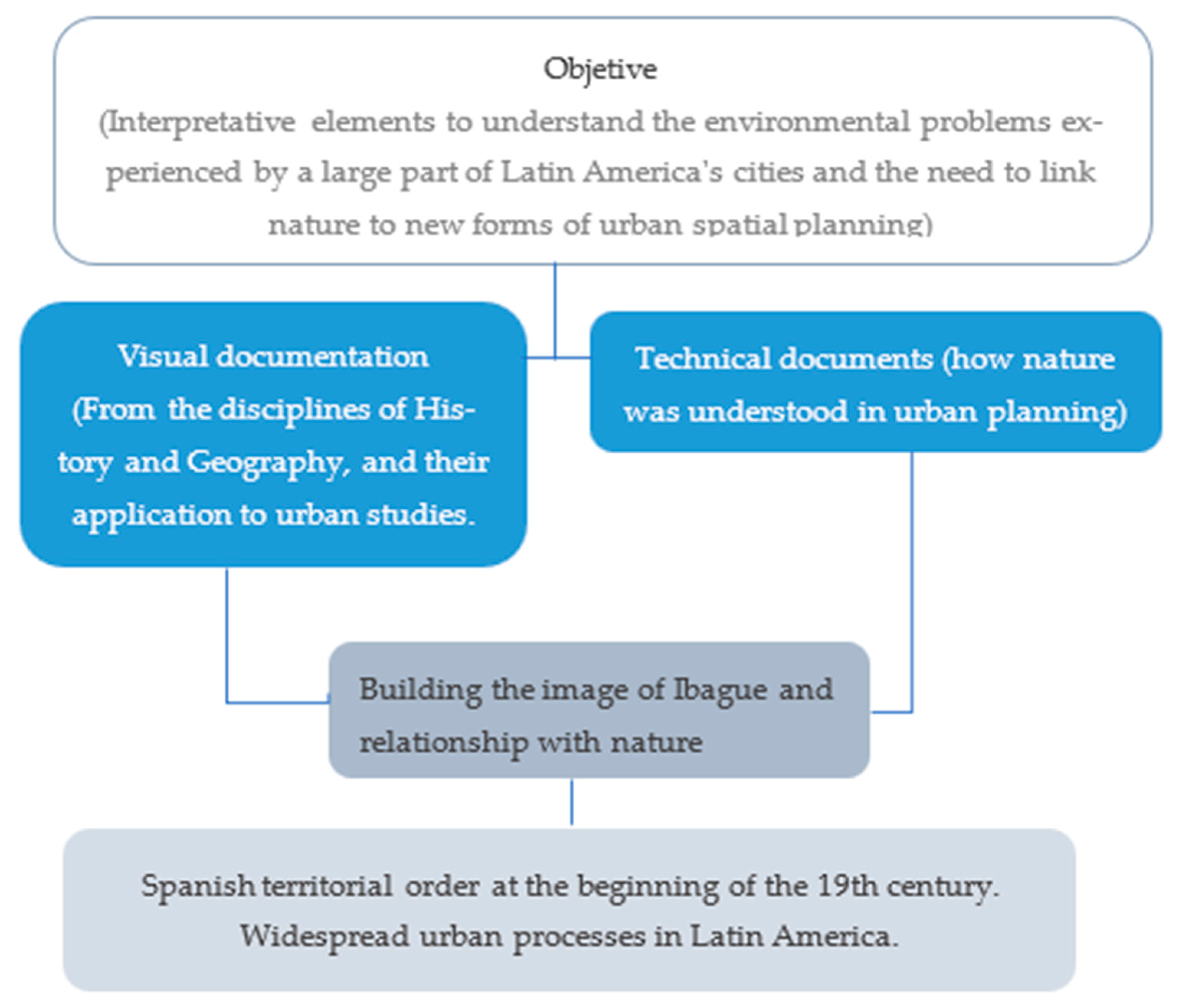
2. Materials and Methods

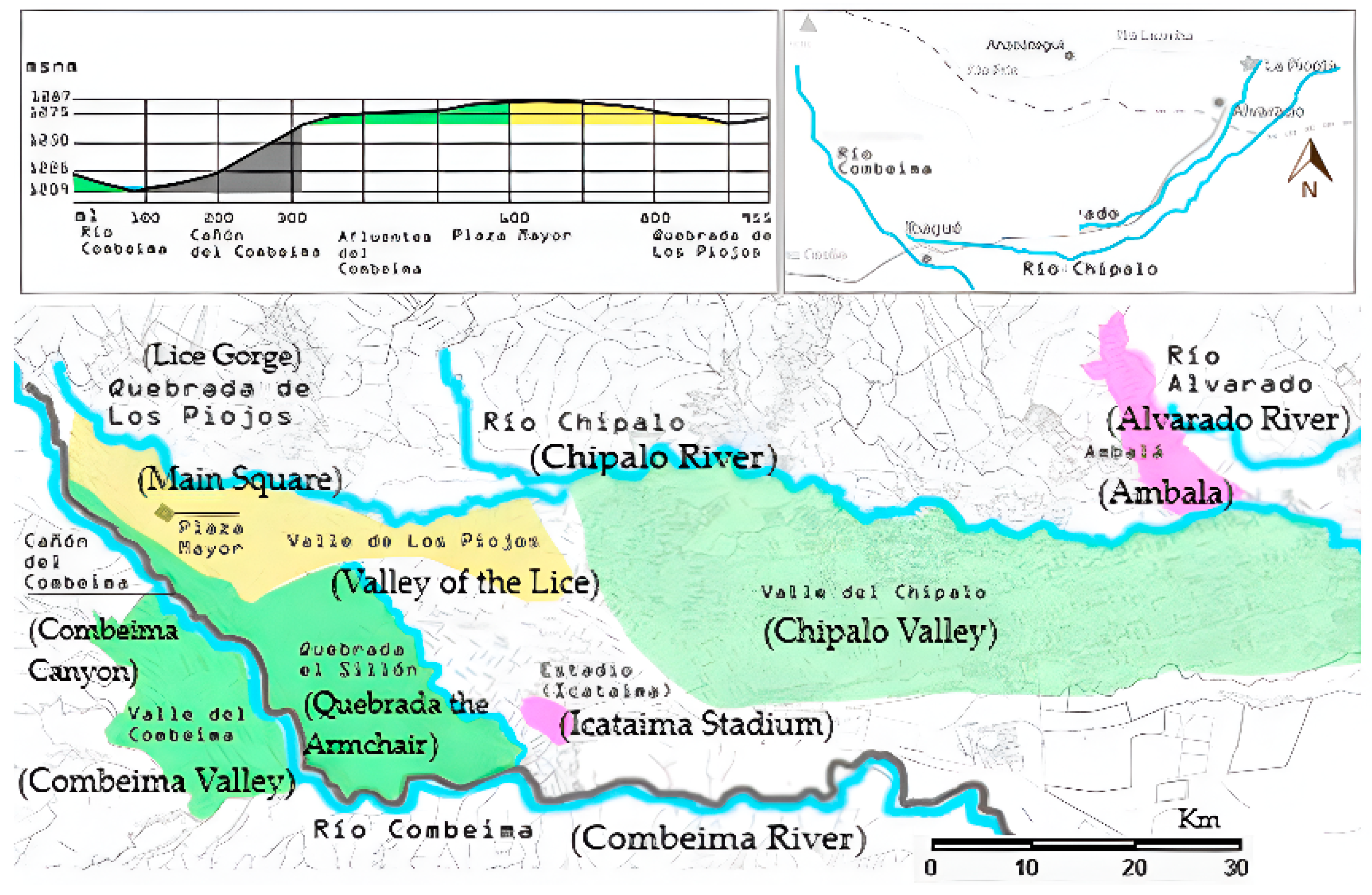
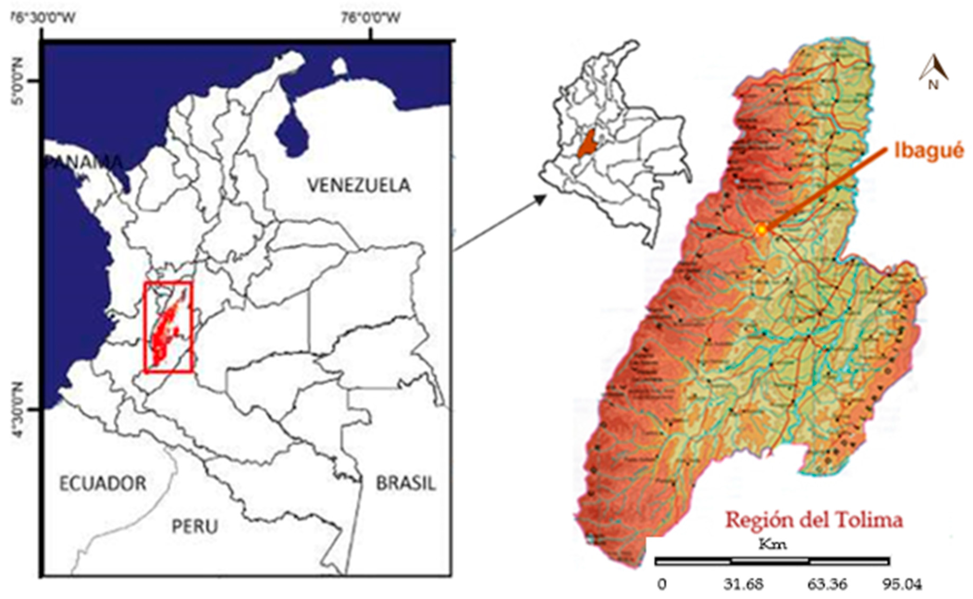
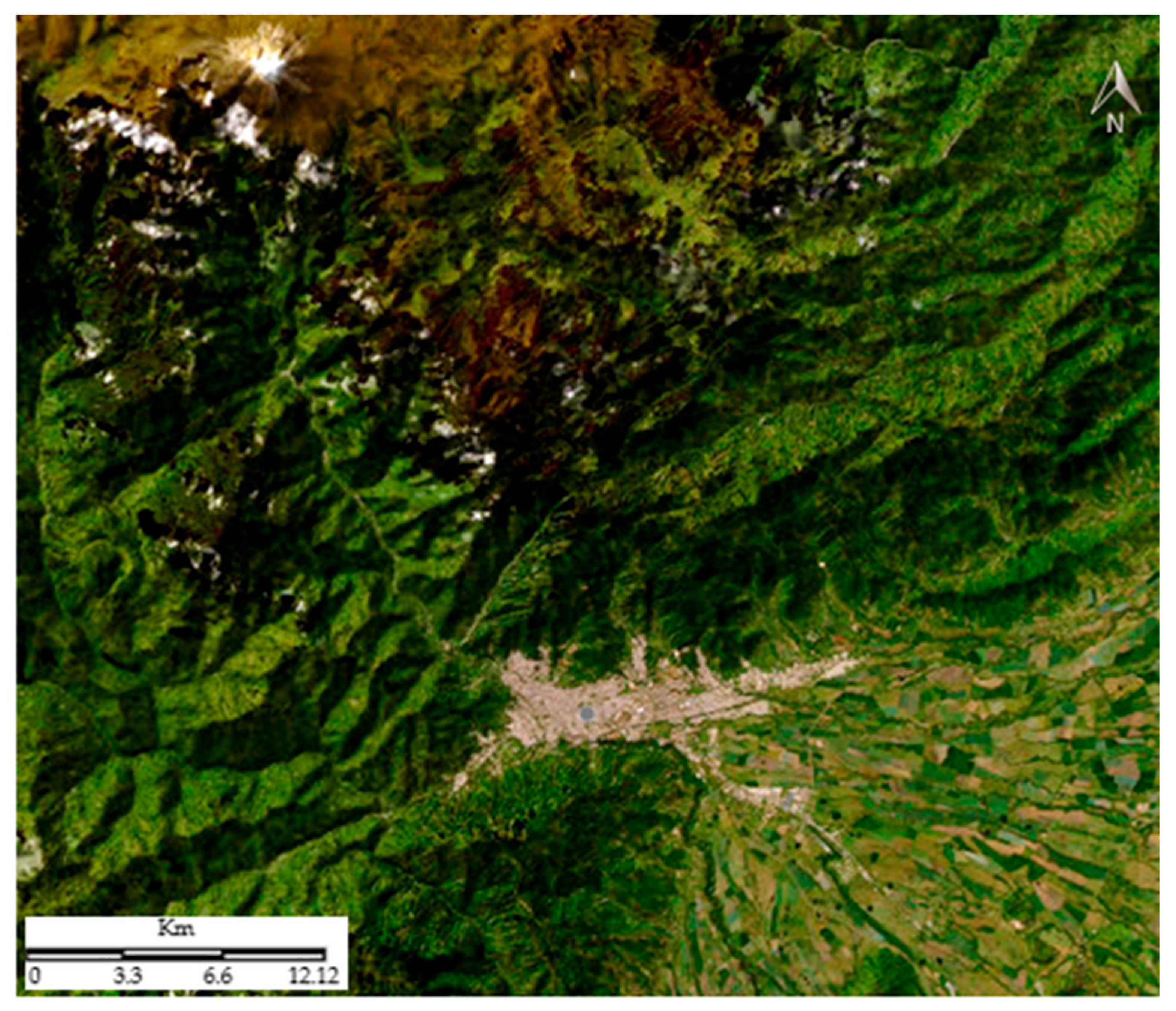
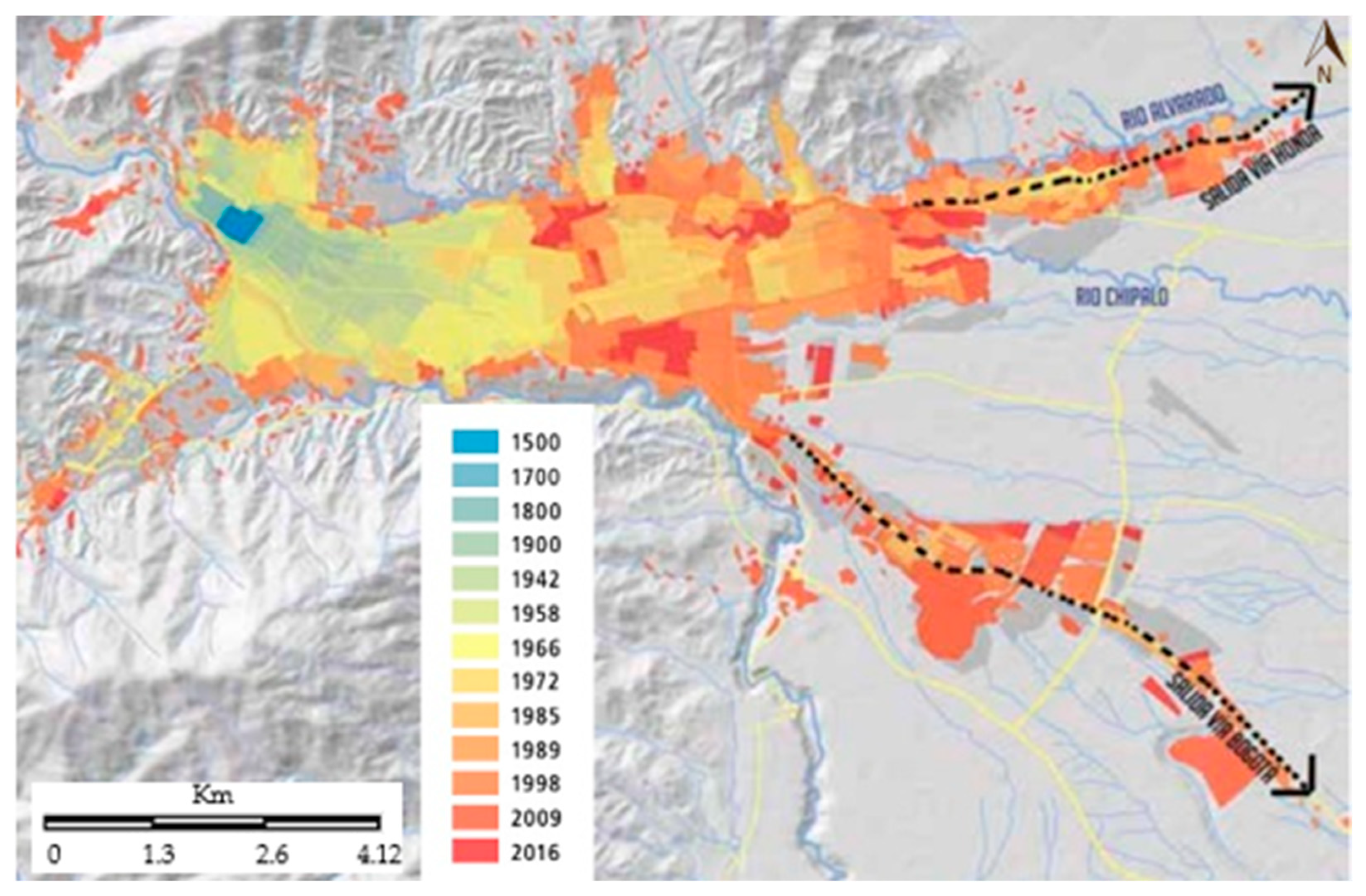
2.1. Case Study: Ibagué (Colombia)

The city of Ibagué is located in the center-west of Colombia, in the foothills of the Central Mountain Range and the upper part of the valley formed by the Chipalo, Combeima, and Coello rivers, with an approximate area of 140,588 hectares, according to the 2000 Land Use Plan. In the Colombian urban context, Ibagué appears as an intermediate city. The population growth dynamics of the last three decades project it as one of the Colombian metropolises with the most significant growth in the coming years, going from a population of 54,347 in 1950 [7] to a population of around 515,000 inhabitants, according to the 2005 census and a projection of 600,000 inhabitants by the year 2025 [8].
Starting from the common history that Ibagué shares with many Latin American cities, the article is approached from the Braudelian proposal of the longue du-rée [9]. This is a theoretical perspective in which, unlike the short times or times of the event, Braudel [9] proposes the notion of longer times for historical analysis: the times of civilization. In this study, it is applied to the times of Latin American urban civilization. The proposal on the city–nature relationship is inscribed in this temporality to analyze how the city of Ibagué adapted to the obstacles of the geographical environment in a period that generally begins with the arrival of the Spaniards in the New World.
It starts from a global to local analysis. Much of the processes of the city in Latin America are addressed and transferred to the case of the city of Ibagué (Figure 2 and Figure 3). The starting point is the way in which nature has been a determining factor in the urban growth of Ibagué. Charles Tilly’s research [10] (p. 702) constitutes a reference point according to which urban historians have become the most important. He states, “In principle, urban historians have the opportunity to be our most important interpreter of the ways that global social processes articulate with small-scale social life”.

2.2. Methodology

The methodology used is of a historical and geographical nature, which implies an analysis of the spatiality of the city over time. It starts from the question of the image that has been constructed of nature and the city throughout history, intending to generate interpretative elements to understand the environmental problems experienced by a large part of the cities in Latin America. Figure 4 shows a sketch of the methodology based on the territorial analysis of the Latin American city applied to the case of Ibagué from a historical perspective.
The analysis of visual sources on the territory has a special relevance. In this perspective, the study refers to the construction of images of the city of Ibagué and its relationship with nature over a long period of time and thinking about visual representations from the disciplines of history and geography and their application to urban studies [13,14,15]. The article gathers images from different periods: pictorial works, photographs, engravings, maps, and images that complement other sources used to think about territorial planning.
Although the research focuses on the case study of the city of Ibagué and its relationship with nature, this research responds to a constant in many Latin American cities. The study addresses the form of territorial planning established by the Spaniards in these territories until the first decades of the 19th century. Later, this territorial organization would be given via urban processes common to many Latin American cities [3].
The analysis of the sources is based on the fact that many of the local policies obeyed ordinances established on a larger territorial scale, as is the case with the ordinances of the Indies and their application in Latin American territories or with the Colombian land-use plans and their application in the pilot plans established by the city of Ibagué over time. The way in which some local sources of the city of Ibagué—press, chronicles, minutes, and decrees of the Municipal Council, or pilot plans—conceived nature within urban planning is analyzed.
Similarly, historical geography, as the dominant sub-discipline in this article, attempts to show that urban planning, as a historical process, has linked nature to the city. Therefore, the analysis of this process has served to study current environmental problems and the need to link nature to new forms of urban spatial planning.

3. Results

3.1. Nature as a Limit and Resource

The founding of cities in Latin America was determined from the first decades of the 16th century by the need to establish control over a nature that was unknown and that fulfilled the dual function of being an obstacle and a resource for the process of conquering the territories of the New World; it was an obstacle because there was no knowledge of it: rivers, forests, fauna, and flora were unknown, nor was there any knowledge of the inhabitants of these territories to whom an untamed nature was attributed and of whom it was doubted whether they even had souls. But nature was also considered a necessary resource for the survival of the populations. For this reason, some chroniclers, such as Pedro Cieza de León [16], stressed the importance of knowing nature and describing the customs of the inhabitants of the new world.
From the first laws of the Indies, both Charles V and Philip II emphasized the importance of certain natural conditions for the foundation of towns and cities, as can be seen in the ordinances of Charles V in 1523 on some principles for settlement, which stated: “When laying out the site… Try to have water nearby, and that it can be brought to the town and estates, diverting it if possible, to make the best use of it, and the necessary materials for the buildings, valuable land, culture, and pasture, which will excuse the much work and costs that follow from the distance… in the case of building on the banks of a river, arrange the settlement so that the sun rises first on the town rather than on the water” [17] (p. 46) (translated from Spanish).
Ordinance 35 of 1573 also established all the advantageous factors to be considered in those places to be founded or settled that would guarantee that the foundation would last: abundant natural resources, sufficient water, stone, and wood for building, climate “not unhealthy”, ease of defense [18].
The city of Ibagué, as a result of these ordinances, was located both on the site of the old city founded in what is now Cajamarca and in its current settlement, around an area rich in natural resources, including the surrounding rivers, Anaime and Vermilion, in the former, and Combeima and Chipalo in the latter, as well as the mountains near these cities for their wealth of gold, timber, and other vital resources, both for the functioning of the city and for fulfilling the fundamental mission of sending precious minerals to the metropolis (Figure 5).
Even though the wealth of natural resources was a condition for founding and populating, many cities in Latin America grew at the expense of the gradual disappearance of the nature surrounding them. Nature was necessary as a resource, but within the Spanish logic of the culture of conquest, one could say, as Georges Foster [20] calls it, that nature, like all elements alien to Spanish culture—religion and traditions—is subjected to the construction of an increasingly artificial urban space. The nature of a large part of the territory surrounding the colonial city was intervened to make way for the sowing of agricultural products or raising livestock. Similarly, the rivers became, from the founding period onwards, the recipients of all the city’s filth, and all the native vegetation disappeared from the settlements, giving way to completely artificial public spaces. This idea of the city as a cultural artifice is imposed on the old traces of trees and rivers, leaving them as the limit of its growth.
Since colonial times, tributaries such as Los Piojos or the Combeima River in Ibagué became natural limits to urban growth; their landscape reflected the life of a city that until the end of the colonial period was still at a fairly slow level of development as were the lives of its inhabitants, which were still defined at the end of the 19th century as calm and silent, as evidenced in the press of the region of El Tolima: “It can be assured that the only noise to be heard here is that formed by the waters of the Combeima, which, in spite of nature, move lazily” [21] (p. 6) (translated from Spanish).

3.2. The Triumph of the City over Nature

Even though nature became the main limit of urban growth regulated by the laws of the Indies, these laws made little reference to how the edges of the cities were to be occupied, or they were only mentioned in the fortress cities, in which the walls or other forts were a decisive part of the city’s defense. The areas furthest away from the city center, ejidos and dehesas, were only mentioned as areas for future urban expansion or as spaces integrated into the city for grazing and feeding the animals that passed through the city or served as a bridge between urban and rural areas.
This denial of borders as planning elements in the founding of towns meant that the urban form was configured with the historic center or main square as a reference point. The main square was a large open space that took on life and importance due to the weekly market, the collection of water from the city’s central fountain, and the different political and religious events that were held there. In addition, the main square was the stage where a large part of the inhabitants’ daily life took place and where the city’s administrative center was located (Figure 6).
The squares and small squares fulfilled a similar function to the main square, integrating the new spaces built in the city but without taking nature into account as an integral part of the city, believing that the natural elements surrounding the city were sufficient to maintain the environmental balance: “Water, a line of mountains, a volcano or an isolated hill, a ravine or simply the forest were, moreover, close enough and formed an integral part of the urban visual realm, favored by the low height of the buildings, to introduce variables rich in colors, textures, and movement. They were natural elements integrated into the urban environment, examples of the qualitative differences between the natural and man-made environment. It was only necessary to look up or walk a few hundred steps to perceive this difference” [23] (p. 318) (translated from Spanish).
With some local variations, this idea of the city remained in force in many Latin American cities throughout most of the colonial period. It only underwent its first changes at the end of the 19th century, a period in which, following the example of some European cities, nature began to be given a place in the city, understood as a domesticated nature, as can be seen in the creation of some avenues and, especially, in the appearance of the park with gardens and trees, following the French model.
In Ibagué, the image of the colonial city surrounded by nature outside the city is still quite visible in the first decades of the 20th century, as can be seen in Juan Lozano’s chronicle of the city in 1935: “... The seven lamps of architecture have not lit their lights in our land, but the landscape there has an inimitable softness. As soon as the plain is finished, Ibagué sits on the first superimposed hills, first in slow steps, then steeper and steeper, of the mountain range; it thus participates in the vision of the burnt plain, which is like a sea of gold, the patriarchal scenery of the oteros, and the nearby shelter of the towering peaks that the snow eternally crowns. A river, sometimes sweet and sometimes turbulent, runs through the outskirts of the village, and its meadows are fertile and green under the changing light filtered by the branches of the trees” [24] (p. 8) (translated from Spanish).
This image of the city refers to a city surrounded by abundant nature and in whose interior a deserted landscape of squares, small squares, and streets was still dominated by local architecture without much ornamentation. In the newspaper La Crónica [25], the squares and parks are referred to as completely wild and treeless places: The only square in the city, where Plaza de Bolívar is today, had the natural soil of the earth, which made it difficult to arrive to the square to go to the Sunday market—the big market—from 6 in the morning to 3 or 3 in the afternoon, and to the daily market, which closed at 8 in the morning.
Nevertheless, at the same time, the city was moving towards modern life, as reflected in the transformation of the old Santo Domingo square (later called San Simón) into Murillo Toro Park, as a place where a domesticated nature began to take shape through newly planted trees and gardens. The idea of the park emerges as a place for meeting and socializing, in which nature is manipulated in a way that is in keeping with the ornamentation of the place. The notion of the park is understood as a sign of progress that replaces the old idea of the main square or the small squares that dominated the colonial space of Ibagué. In the newspaper La Hoja on 14 October 1893 [26] (p. 12), the transition to modern life is mentioned in this way: “We are assured that we will soon have a park, in what is now the small square of San Simón. An idea of progress that is well suited to the aspirations of a cultured people” (translated from Spanish) (Figure 7).
The main square was transformed into Bolívar Park, expelling the weekly market and the domestic animals that used to pass through it, facilitating the planting of gardens and trees which, to this day, define the landscape of the place and of the new avenues of Ibagué. In the 1912 census, the role played by nature in the modernization of the city was emphasized, highlighting the presence of gardens and trees in the parks and small squares: “The main square, currently embellished by a complete grove of trees, will soon be a park dedicated to the liberator. One block from the square is the Murillo Toro Park, a small and cheerful garden where national gratitude will erect a bronze to the eminent tribune and statesman of Tolima…” [28] (p. 285) (translated from Spanish).

3.3. The Urban Edge as a Reference Point for Environmental Planning in the City

Taking into account Osvaldo Sunkel’s [29] assertions that the environment is the natural biophysical environment and its successive transformations, as well as the spatial deployment of these transformations, it could be affirmed, in this perspective, that environmental history is the history of biophysical transformations and their relationship with the transformations that human beings develop in this space. Within these transformations, the city, according to Lewis Mumford [30], is the expression of the greatest territorial artifice since the domination of technology over nature allows the city to grow by overcoming the obstacles that topography or the different water sources impose on it. This fact, together with the new way of traveling through the territory by car in Latin American cities, changes the idea of order that had been established from the main square, making possible the transition from a dense city, such as the one established in the colonial period, to a fragmented and diffused city in which population logics emerge marked by multiple urban centralities.
Nature, which was understood as an artifice within the city, is used on the periphery as a place for those marginal inhabitants, most of whom are newly arrived from the countryside, who find in their condition of limit the possibility of a dwelling in places that later urbanists will call as belts of misery or subnormal neighborhoods. These slums, which survive on the banks of the rivers and ravines of the city, coexist with many other sectors of the city in which nature is used to clean a city that still has not installed an efficient public sewerage system. In the Minutes of the Municipal Council, published in 1918: “One of the main causes for which the population lives so unhinged, is in doubt, the system of flowing waters. And here, one can refute the pilgrim argument of some, who say that via such a system, the cleansing of the city is performed perfectly and that such an assertion is still convenient, which is simply absurd; let us see. While it is true that the water running through the pipes makes the toilet of the upper part of the city because, by the same decline, the current drags all the trash, it is no less true that such garbage is attached to it, within the city, in the same main square, where water runs almost to the level, and so they look every day, the pipes clogged by garbage, and great puddles in the camels, which it constantly damages…There is more: in some houses, they take the water from the pipes to wash the toilets, and after passing through them, they return to their course loaded with fecal matter…” [31] (translated from Spanish).
Unlike other Colombian cities, especially Medellín and Bogotá, which since the first decades of the 20th century had implemented some elements of urban planning, especially prospective plans, Ibagué was a city that was being built on the idea of responding to immediate needs. In the aforementioned Minutes of the Municipal Council, it can be evidenced that the municipal authorities, like the Ornate Society, were responsible for planning urban development. Within the planning of urban development, nature constituted a form of embellishment and played a leading role in the management of parks and streets near the historic center; this fact is evident in the reconfiguration of a new urban periphery, as evidenced in the pilot plan of 1935 [32].
In 1935, although a contract was signed with a Bogotá firm of engineers to design the city’s first pilot plan, this plan was never implemented. Much of the ideas raised in it were questioned because of their inviability in the city. According to the chronicles of the time, this plan was intended for an imaginary city and not for Ibagué. Despite this, the plan based the articulation of the city of Ibagué on the new policies of urban growth. The urban historian Andrés Francel [2] rescues, within this plan, the articulation of elements such as topography and vegetation to the new planning policies of the city, showing how some natural elements were taken into account in the design of the urban edge that began to urbanize around the creek or ravine El Sillón (Figure 8). In this regard, he stated: “Instead of real estate developments, the generation of forests was proposed to take advantage of the characteristics of the soil and the topography of the ravine. The city was endowed with a large public space that it lacked and required in the future. The forest was generated on the strongest slope of the ground to stabilize the soil in a strip ranging from 120 to 300 m wide” [2] (p. 18) (translated from Spanish).
Chronicles of the time show that most of the ideas contained in the 1935 pilot plan were not taken into account, and serious prospective planning was only carried out in 1966 when the city had grown rapidly as a result of population migration caused by bipartisan violence and the attraction of the city as a place to live since the mid-twentieth century.
In the pilot plan of 1966, the city of Ibagué begins to think not only from the dimensions of an intermediate city in the Colombian urban context but also from the need for planning that focuses on future urban space evolution. This plan proposes the design of roads and growth areas surrounded by a green belt that referenced the conservation of the hills that bordered the city. It also specifically proposes the need for policies to conserve the banks of the rivers and streams that run through the city. However, it was not contemplated to keep the rounds—that is, the margins of the rivers—since they were gradually invaded and then converted into permanent settlements with the consent of administrations and complacent lobbyists, who had endowed them with the infrastructure of services.
In the implementation of the pilot plan of 1966, although some ideas aimed at articulating nature to the city failed, according to Carlos Martínezz Silva, the idea of thinking of nature as an important element in the city’s planning took on much strength from that plan [33]. The role of nature is evident in the process of arborization in the road development of the city in the later decades and the conservation of the vegetation of the northeastern hills of the city. In this pilot plan, the urban edges no longer constitute a fixed limit of the built or built part of the city but an integral part of it. Wild nature begins to stop being conceived as the fixed edge of the city to become an interface between the new urban–rural dynamics that characterize contemporary spatiality.

4. Discussion

The Redefinition of Urban–Rural Dynamics as a Return to Nature

The monographic report of the Inter-American Development Bank (BID), derived from the Emerging and Sustainable Cities Programme (2015), shows the importance of water resources in the history of Western cities. The report states: “The vast majority of Latin American cities have also been born next to a water source, and their morphology has always been related to the evolution of water flow. But, since the middle of the last century, the accelerated and unplanned growth of Latin American cities has meant that most of these water bodies, which were in many cases the very origin of the locality, have become backyards or directly sewers” [34] (p. 11).
Despite the importance of the relationship between water sources—water resources—and the city, or urban space and nature, they have not always been integrated into urban planning beyond specific actions. In this respect, Emir Espinosa states, “Rivers have historically been at the center of the foundation of Latin American cities. However, their enhancement has long been seen by politicians and authorities as a one-off or even ornamental urban intervention, without understanding their capacity to articulate the urban fabric and mobility” [35] (p. 1). This fact implies a double effort in urban planning. In the case of the city of Rosario in Argentina, the IDB report states: “Reversing the degradation of a river (or a stream, ravine, lake, waterfront, among others), recovering the quality of its water or making its banks habitable seem unmanageable tasks after decades of neglect and mismanagement” [34] (p. 11).
Faced with these processes of recovery or integration of nature into urban planning, projects have been promoted to reduce damage to nature in urban space, especially prioritizing the recovery of bodies of water, water accumulation on the surface [34] (p. 11), as is the case with the reception of the guidelines proposed by the World Health Organization, where it states: “Joint intervention in water management, risk prevention and the creation of public green spaces in urban stretches of rivers or coasts is not only a priority, it is a profitable investment and an opportunity to regenerate the urban fabric of cities” [36] (p. 14).
From this perspective, policies to protect urban edges or linear parks around rivers and streams have been promoted in most Latin American cities. There are actions in linear parks in Brazil, such as multifunctional spaces with the potential to provide alternatives to drainage and urban water problems [37]. In Colombia, it is worth mentioning the development plans of most cities, which have developed nature protection actions as a constant policy since the last decades of the 20th century. The Ibagué Pilot Plan of 1966 envisaged: “The development plan of a large city and its region must include a type of green zone (...) which allows another form of expansion of urban crowds in general (...) this green zone allows the fullest contact between man and nature (...). We are referring to the large green zone, outside the city limits (...), a forest belt which totally encloses it. In the case of Ibagué, each green belt would be formed by the banks of the Chípalo and Combeima rivers, both with their respective tributaries” [38] (p. 75) (translated from Spanish).
In the Colombian case, it is also important to point out that the processes of urban land occupation have occurred as a contrast between the real city and the formal city. That is to say, on the one hand, there are the norms established by land-use plans and, on the other, how the different social actors appropriate space in the city. This is explained by the fact that while a large part of the urban peripheries were occupied illegally, it has only been in recent decades that planning offices have issued new regulations to protect the edges of cities, which for a long time were delimited by the banks of rivers and streams that surround the cities.
In Agreement 116 of 2000 of the Ibagué Land Use Plan (POT), the protection of riverbanks and peri-urban edges is contemplated for the first time. This plan states: “Specific Identification and Regulation for Areas of Conservation and Environmental Restoration in the Rural Soil of the Municipality of Ibagué. The strip of the 30 m side and side of the streams of rivers and streams and the 100 m radius of the water births, where environmental recovery and improvement projects should be located and prioritized, coordinated and concerted with the environmental authority and the rural population, through reforestation, isolation and management plans. Main use: Protective forest, natural regeneration, works for recovery and erosion control. Compatible use: Protective forestry activities—production with native species, contemplative recreation, extraction of trawling material. Conditional use: Reforestation activity, induced revegetation, access roads veredal, agroforestry. Prohibited uses: Intensive agricultural exploitation, parceling for housing construction, urban expansion areas” [39] (p. 29) (translated from Spanish).
The provisions of agreement 116 show the greatest importance of nature in territorial planning, not only for the sake of its conservation but also because it remains the clearest physical boundary between rural and urban. Thus, the different water resources become a brake on urbanization, not only because of the restrictions imposed to build close to its edges but also because from them, the rural world begins to be defined, relating it to farms or the protection of native ecosystems. Article 4 of the same POT states: “The territory of the Municipality of Ibagué, as defined in Law 388 of 1997 and by its own characteristics, is classified into urban, rural, and urban sprawl. Law 388 of 1997, due to its own characteristics, is classified into urban, rural, and urban sprawl. Within these classes, the categories of suburban and protection may be established” [39] (p. 89) (translated from Spanish).
Within the POT, urban is defined as the area within the urban perimeter; rural is defined as the municipal area outside the urban and expansion perimeters. It follows that a fundamentally physical delimitation marked the boundary between the urban and the rural world: the point up to which the last building or settlement bordering a given water resource reached. This definition assumes that the city, as a synonym for the urban, continues its expansion and growth in a dense manner from the historic center, as is typical of the colonial period. But it does not take into account that modern cities, including Bagué, have focused their development on the model of spatiality in which the territory begins to reproduce itself in an increasingly dispersed manner (Figure 9).
This dispersed city model, evident in Latin America since the mid-20th century, indicates a change in how the urban is named, where the definitions included in the city’s development plans are insufficient. The definition of the urban as synonymous with the city or as opposite to the rural world, a definition based on population or housing density, as reflected in POT 2002, has been rethought for more than a century by the social theory on urban space, bearing in mind the growth of European or North American cities. Horacio Capel [41] summarizes the definition of the urban. At the same time, the border between the city as synonymous with the city and the countryside has been addressed by Georges Duby in his work La Histoire de la France Urbaine, where he writes: “With all evidence, the oldest division between the countryside and the city is erased under our eyes, and this fact is revealed as one of the most drastic mutations affect our civilization. The fusion between the countryside and the city is precipitated” [42] (p. 6) (translated from French). This peri-urban border generates great reflection on new territorial panification policies for much of modern urban contexts [43,44,45,46,47,48]. In this debate, the discussion takes effect on a third planning space between the urban and the rural but marked by the hybridization of both concepts or, according to Ruosso and Plant cit. Vanier [49,50], “The conception of peri-urban areas as a third space suggests that they are not destined to become urban, but rather to exist as a unique, third type of space in between urban and rural spaces. As such, third space has its own identity, its own set of challenges, and its own spatial planning needs” [50] (p. 57).
This new perception of the urban, which also implies a new perception of rural space [51] (p. 56), is reflected in the planning of Latin American urban space or, in this case, of the city of Ibagué, assuming urban change as a complex social transformation, in which it predominates every time individual experience prevails over community life [52] (p. 34).
In this context, the urban border is no longer understood merely on a fixed basis as in the traditional planning of the territory but is understood as a constantly changing border. This new scenario is posed, characterized by a discontinuous spatiality or “like a space of archipelagos” [4] (p. 27) (translated from Spanish); the urban does not conclude where the rural begins but extends as a hybrid and mobile territory in which anonymous and communal relations coexist. The city, as a physical structure built at the cost of the deterioration of nature in which it was located, loses attractiveness for many of its inhabitants who seek in the countryside a place of evasion to the environmental problems produced by the city’s growth.
The city’s edges become the ideal place for some inhabitants to find the solution to the environmental problems within the urban mesh. The inhabitants with high purchasing power seek the image of pure nature, located outside the urban mesh, to escape from the noise, pollution, insecurity, and other problems caused by the city’s growth. According to a popular adage, the countryside attracts because the city expels. In this case study, the countryside attracts because it becomes the dream paradise where you can produce a utopian reunion with the lost nature, destroyed throughout the city’s history. Likewise, the edges of the rivers, which remain outside the planning, will be, for the poor, the place to prolong their struggle for the occupation of uncontrolled public areas in response to the denial of the right to the city that the dominant society denies them.
The search for nature in the residential space is reflected in agreement 116 of the POT of Ibagué of 2000, where the park is defined as a free space in the city’s interior intended for outdoor recreation and contact with nature. Landscape and natural values predominate in the park over any architectural element that conforms to or is arranged inside. However, the parks no longer meet the demand of the city’s elites, who are beginning to yearn for a closer relationship with nature. The idyllic around the countryside leads to the urban being expressed in an increasingly discontinuous space. The new elitist neighborhoods are built as a green imaginary (Figure 10 and Figure 11), and this fact is expressed in the name of the new urbanizations, which constitute closed residential complexes: Paseo del Vergel, Vergel roads, Vergel forests, Aguaviva del Vergel Portal del Campestre, Montecito del Carmelo, Palmar del Río, etc.
This new relationship with nature, which transcends the perimeter of the city, is the expression of an urban world that expands throughout the territory, ignoring the traditional limits and transmitting not only a homogeneity in the urban culture but also transferring to the territories surrounding the environmental problems of the city.

5. Conclusions

Understanding nature and society relations through history is fundamental to understanding many of the environmental problems that many Latin American cities currently experience. However, in cities like Ibagué, urban planning is short-sighted. It envisages the resolution of the immediate problems essentially without thinking of an order in which the importance of the past facts is taken into account in order to explain the problems that the current societies suffer, as happened for a long time, to the exclusion of the nature of the urban planning policies.
The study of the history of the city and its relationship with nature allows us to see how much of the urban centers have grown, undervaluing and turning their backs on nature. Environmental crises demand more nature-friendly territorial logic. The analysis of the relations between nature and society in the long term favors a dialogue between history and the social sciences, opening new possibilities to think of urban problems as a historical product.
Considering nature as an urban plumber implies assuming the planning of cities in a systematic way, not only as the point of separation from the immediate rural environment but also with those territories that, under the model of a diffuse city or archipelago city, are articulated to the historical center in a spatial logic in which the continuity of the urban trace ceases to be determinant. It is important to articulate to the plans of territorial organization new policies that allow a planning of the peri-urban borders of the city, assuming these as territories in which the most immediate growth of the city is projected and in which the articulation with nature becomes an imperative of the new urban order.
The return to nature as an increasingly marked condition within modern society involves articulating new policies to develop real estate projects and preserve the environment, not only within the edge of the city but also in those territories in which the urban expansion of cities such as Ibagué and other Latin American cities extend their area of fluency.

Author Contributions

Conceptualization, J.L.G.-C. and O.M.A.; methodology, J.L.G.-C. and C.A.S.C.; software, O.M.A.; validation, J.L.G.-C. and O.M.A.; formal analysis, O.M.A.; investigation, J.L.G.-C. and C.A.S.C.; resources, J.L.G.-C.; data curation, O.M.A. and J.L.G.-C.; writing—original draft preparation, J.L.G.-C. and O.M.A.; writing—review and editing, O.M.A.; visualization, J.L.G.-C. and O.M.A.; supervision, O.M.A. and J.L.G.-C.; project administration, J.L.G.-C.; funding acquisition, J.L.G.-C. All authors have read and agreed to the published version of the manuscript.

Funding

Proyecto “Nuevas formas del espacio urbano: Propuesta de identificación de lugares de centralidad en Ibagué”. Código 370130517. Oficina de Investigaciones y Desarrollo científico. Universidad del Tolima.

Data Availability Statement

Data is contained within the article.

Conflicts of Interest

The authors declare no conflict of interest.

References

  1. Altamira y Crevea, R. Ordenanzas del Descubrimiento y población dadas por Felipe II en 1573; Jaus: Ciudad de México, México, 1950. [Google Scholar]
  2. Francel, A. Historia y Patrimonio de la Periferia Interior de Ibagué; Casa de Libros: Ibagué, Colombia, 2017. [Google Scholar]
  3. Romero, J.L. Latin America. Its Cities and Ideas; Azar, I., Ed.; Cultural Series 59; Interamer Collection: Washington, DC, USA, 1999. [Google Scholar]
  4. Naredo, J.M. Diagnóstico Sobre la Sostenibilidad: La Especie Humana Como Patología Terrestre; Cuadernos de Crítica de la Cultura: Archipiélago, México, 2004; Volume 62, pp. 13–24. [Google Scholar]
  5. Santos, M. La Naturaleza del Espacio: Técnica y Tiempo; Razón y Emoción; Ariel Geografía: Barcelona, Spain, 2000. [Google Scholar]
  6. Lefebvre, H. La Production de l’Espace; Anthropos: Paris, France, 2000. [Google Scholar]
  7. González, J.L. De la Ciudad al Territorio. La Configuración del Espacio Urbano en Ibagué: 1886–1986; Aquelarre: Ibagué, Colombia, 2006. [Google Scholar]
  8. DANE. Censo Nacional de Población y Vivienda; Dane: Bogotá, Colombia, 2018. [Google Scholar]
  9. Braudel, F. History and the Social Sciences: The Longue Durée. Review 2009, 32, 171–203. [Google Scholar] [CrossRef]
  10. Tilly, C. What good is urban history. J. Urban Hist. 1996, 22, 6. [Google Scholar] [CrossRef]
  11. IGAC. Cartografía Básica; IGAC: Bogotá, Colombia, 2022. Available online: https://glx-gov-esri-co.hub.arcgis.com/apps/22c21604d7654cf38116827da3e41701/explore (accessed on 19 August 2023).
  12. SINUPOT. Secretaría Distrital de Planeación. 2023. Available online: https://glx-gov-esri-co.hub.arcgis.com/ (accessed on 13 August 2023).
  13. Da Costa, P.; Berdoulay, V. Imagens na geografia: Importância da dimensão visual no pensamento geográfico. Cuad. Geografía. Rev. Colomb. Geogr. 2018, 27, 356–371. [Google Scholar] [CrossRef]
  14. Berdoulay, V.; Da Costa, P.; Maude, L.J. L’image dans l’écriture géographique: Enjeux épistémologiques et valeur heuristique. Géogr. Cult. 2015, 93, 153–173. [Google Scholar] [CrossRef]
  15. Driver, F. On Geography as a Visual Discipline. Antipode 2003, 35, 227–231. [Google Scholar] [CrossRef]
  16. Cieza de León, P.D. Crónica del Perú; Pontificia Universidad Católica del Perú: Lima, Peru, 1994; Folio 4V. [Google Scholar]
  17. Martínez, C. Apuntes Sobre el Urbanismo en el Nuevo Reino de Granada; Banco de la República: Bogotá, Colombia, 1967. [Google Scholar]
  18. Blanco Barros, J.A. Fundaciones coloniales y republicanas en Colombia: Normas, trazado y ritos fundacionales. Credencial Hist. 2001, 141, 17–32. Available online: https://www.banrepcultural.org/biblioteca-virtual/credencial-historia/numero-141/fundaciones-coloniales-y-republicanas-en-colombia (accessed on 19 August 2023).
  19. Biblioteca Luis Ángel Arango: Bogotá, Colombia, Fondo: AP2121.
  20. Foster, G. Culture and Conquest. America´s Spanish Heritage; Viking Fund Publications: New York, NY, USA, 1960. [Google Scholar]
  21. Journal El Tolima, Ibagué, Colombia, 30 August 1888.
  22. Archivo de Memoria Visual; Biblioteca Darío Echandía: Ibagué, Colombia, 1922.
  23. Hardoy, J.E. La forma de las ciudades coloniales en la América española. In Estudios Sobre la Ciudad Iberoamericana; De Solano, F., Ed.; CSIC: Madrid, Spain, 1983; pp. 315–344. [Google Scholar]
  24. Lozano, J. Ibagué Tierra Buena. Arte Órgano Conserv. 1935, 16, 2–7. [Google Scholar]
  25. La Crónica, Ibagué, Colombia, 2 June 1933.
  26. La Hoja, Ibagué, Colombia, 14 October 1893.
  27. Saffray, C. Geografía Pintoresca de Colombia: La Nueva Granada Vista por dos Viajeros Franceses del Siglo XIX; Litografía Arco: Bogotá, Colombia, 1971. [Google Scholar]
  28. DANE. Censo Nacional. Colombia, 1912. [Google Scholar]
  29. Sunkel, O. Introducción. La interacción entre los estilos de desarrollo y el medio ambiente en América Latina. In Estilos de Desarrollo y Medio Ambiente en América Latina; Sunkel, O., Gligo, N., Eds.; Fondo de Cultura Económica: Ciudad de México, México, 1980; pp. 1–64. [Google Scholar]
  30. Mumford, L. Técnica y Civilización; Alianza Editorial: Madrid, Spain, 1997. [Google Scholar]
  31. Acta del Concejo Municipal, Número 166; Archivo Histórico de Ibagué (A.H.I.): Ibagué, Colombia, 1918.
  32. Francel, A.; Hormechea, P.; Uribe, C. Types of Land occupation in the urban periphery. Ibagué, Colombia, 1935. In Research Tracks in Urbanism: Dynamics, Planning and Desing in Contemporary Urban Territoires; Allegri, A., Benatti, A., Abascal, E., Sabaté, J., Costa, J.P., Schicchi, M., Eds.; CRC Press: London, UK, 2021; pp. 28–33. [Google Scholar]
  33. Martínez Silva, C. Historia de la Forma Urbana de Ibagué; Alcaldía de Ibagué: Ibagué, Colombia, 1990. [Google Scholar]
  34. Terraza, H.; Pons, B.; Soulier, G.M.; Juan, A. Desarrollo Gestión Urbana, Asociaciones Puúblico-Privadas y Captación de Plusvalías: El Caso de la Recuperación del Frente Costero del río Paraná en la Ciudad de Rosario, Bid. Nota Técnica # IDBMG-303. 2015. Available online: https://publications.iadb.org/publications/spanish/viewer/Gesti%C3%B3n-urbana-asociaciones-p%C3%BAblico-privadas-y-captaci%C3%B3n-de-plusval%C3%ADas-El-caso-de-la-recuperaci%C3%B3n-del-frente-costero-del-r%C3%ADo-Paran%C3%A1-en-la-Ciudad-de-Rosario-Argentina.pdf (accessed on 14 August 2023).
  35. Espinoza, E. Ríos que Dan Vida: Las Ciudades Latinoamericanas Que se Transforman en Torno al Agua El País, Madrid. 2023. Available online: https://elpais.com/america-futura/2023-05-30/rios-que-dan-vida-las-ciudades-latinoamericanas-que-se-transforman-en-torno-al-agua.html (accessed on 10 June 2023).
  36. World Health Organization (WHO). Evaluation of the Costs and Benefits of Water and Sanitation Improvements at the Global Level; Citado por BID Nota Técnica # IDBMG-303, abril 2015; World Health Organization: Geneva, Switzerland, 2004. [Google Scholar]
  37. Mayorga, N. Experiencias de Parques Lineales en Brasil: Espacios Multifuncionales con Potencial para Brindar Alternativas a Problemas de Drenaje y Aguas Urbanas. BID, Nota Técnica # IDBTN-518. 2013. Available online: https://publications.iadb.org/publications/spanish/viewer/Experiencias-de-parques-lineales-en-Brasil-Espacios-multifuncionales-con-potencial-para-brindar-alternativas-a-problemas-de-drenaje-y-aguas-urbanas.pdf (accessed on 15 September 2023).
  38. Instituto Geográfico Agustín Codazzi, Sección de Planeamiento urbano. Plan Piloto de Desarrollo Urbano de la Ciudad de Ibagué; Instituto Geográfico Agustín Codazzi: Bogotá, Colombia, 1966. [Google Scholar]
  39. Alcaldía de Ibagué. Plan de Ordenamiento Territorial; Acuerdo 116; Alcaldía de Ibagué: Ibagué, Colombia, 2000. [Google Scholar]
  40. IDOM, 64, 2016. Studies Base Module 3-Urban Growth. Modified. 2017.
  41. Capel, H. La definición de lo urbano. Estud. Geogr. 1975, 36, 265–301. [Google Scholar]
  42. Duby, G. Histoire de la France Urbaine: La Ville Clasique; Seuil: París, France, 1980; Volume 2. [Google Scholar]
  43. Cahya, D.L.; Martini, E.; Kasikoen, K.M. Urbanization and Land Use Changes in Peri-Urban Area using Spatial Analysis Methods (Case Study: Ciawi Urban Areas, Bogor Regency). In Proceedings of the 2nd Geoplanning-International Conference on Geomatics and Planning, Surakarta-Central Java, Indonesia, 9–10 August 2017; IOP Conference Series: Earth and Environmental Science. Volume 123. [Google Scholar]
  44. Samat, N.; Mahamud, M.; Tan, M.; Maghsoodi, M.; Tew, Y. Modelling Land Cover Changes in Peri-Urban Areas: A Case Study of George Town Conurbation, Malaysia. Land 2020, 9, 373. [Google Scholar] [CrossRef]
  45. Gallent, N. The rural–urban fringe: A new priority for planning policy? Plan. Pract. Res. 2006, 21, 383–393. [Google Scholar] [CrossRef]
  46. Gallent, N.; Shaw, D. Spatial planning, area action plans and the rural-urban fringe. J. Environ. Plan. Manag. 2007, 50, 617–638. [Google Scholar] [CrossRef]
  47. Allen, A. Environmental planning and management of the peri-urban interface: Perspectives on an emerging field. Environ. Urban. 2003, 15, 135–148. [Google Scholar] [CrossRef]
  48. Ravetz, J.; Fertner, C.; Nielsen, T.S. The dynamics of peri-urbanization. In Peri-Urban Futures: Scenarios and Models for Land Use Change in Europe; Nilsson, K., Pauleit, S., Bell, S., Aalbers, C., Nielsen, T.A.S., Eds.; Springer: New York, NY, USA, 2013; pp. 13–44. [Google Scholar]
  49. Ruoso, L.E.; Plant, R. A politics of place framework for unravelling peri-urban conflict: An example of peri-urban Sydney, Australia. J. Urban Manag. 2018, 7, 57–69. [Google Scholar] [CrossRef]
  50. Vanier, M. Qu’est-ce que le tiers espace? Territorialités complexes et construction politique. Rev. Géogr. Alp. 2000, 88, 105–113. [Google Scholar] [CrossRef]
  51. Arlaund, S.; Yves, J.; Rouyoux, D. Rural-Urbain. Nouveaux Liens, Nouvelles Frontiéres; Press Universitaires de Rennes: Rennes, France, 2005. [Google Scholar]
  52. Delgado, M. El Animal Público; Anagrama: Barcelona, Spain, 1999. [Google Scholar]
Figure 1. Water resources have been a determining factor in the history of the urban layout of the city of Ibague. The image shows how the city began to take shape, starting at the Plaza Mayor (yellow area) and following the edge of the Chipalo and Combeima rivers (yellow area), which determine its urban layout, which determined its urban layout. Source: made from [2] (p. 29).
Land 12 01807 g001
Figure 2. Location of the Tolima region and the city of Ibague. Source: made by the Agustin Codazzi Geographic Institute (IGAC). Bogotá [11].
Land 12 01807 g002
Figure 3. Aerial view of the city of Ibague in the Magdalena River Valley. Source: https://glx-gov-esri-co.hub.arcgis.com/apps/22c21604d7654cf38116827da3e41701/explore (accessed on 26 July 2023) [12].
Land 12 01807 g003
Figure 4. Methodological outline.
Land 12 01807 g004
Figure 5. Ibagué in Humboldt’s sketch of the Quindío Road, 1806. Source: Luis Ángel Arango Library Map Library. AP2121 [19].
Land 12 01807 g005
Figure 6. Aguateros Bolivar Square. Source: Photo Daniel Camacho, 1922 [22].
Land 12 01807 g006
Figure 7. Plazuela Santo Domingo and Parque Murillo (Riou engraving). Source: Charles Saffray and Edouar Andre, 1971 (p. 109) [27].
Land 12 01807 g007
Figure 8. Altitudinal distribution of vegetation in the Sillón landscape, 1935. Source: made from Andrés Francel, 2017 [2] (p. 75).
Land 12 01807 g008
Figure 9. Historical evolution of the urban growth of the city. It shows the city’s expansion to the northeast, in the direction of Honda, and to the southeast, in the direction of Bogota. Source: made from Findeter, 2016 (modified, 2017) [40].
Land 12 01807 g009
Figure 10. Urban buildings in the natural area of Ibagué. Source: author, 2021.
Land 12 01807 g010
Figure 11. New residential architecture in the city of Ibagué. Source: author, 2021.
Land 12 01807 g011
Disclaimer/Publisher’s Note: The statements, opinions and data contained in all publications are solely those of the individual author(s) and contributor(s) and not of MDPI and/or the editor(s). MDPI and/or the editor(s) disclaim responsibility for any injury to people or property resulting from any ideas, methods, instructions or products referred to in the content.

