Article

Assessment of Sustainable Development Suitability in Linear Cultural Heritage—A Case of Beijing Great Wall Cultural Belt

1
School of Architecture and Urban Planning, Beijing University of Civil Engineering and Architecture, Beijing 100044, China
2
Beijing Key Laboratory of Green Building and Energy-Efficiency Technology, Beijing University of Civil Engineering and Architecture, Beijing 100044, China
3
School of Architecture, Tsinghua University, Beijing 100084, China
*
Author to whom correspondence should be addressed.
Land 2023, 12(9), 1761; https://doi.org/10.3390/land12091761
Submission received: 13 July 2023 / Revised: 8 August 2023 / Accepted: 30 August 2023 / Published: 11 September 2023
(This article belongs to the Special Issue Urban and Rural Land Use, Landscape and Sustainability)

Abstract

:
The Great Wall is an example of linear cultural Heritage (LCH) subjected to a fragile ecological environment and unbalanced economic development. However, no studies have been conducted to assess the sustainable development suitability (SDS) of the Great Wall region. Heritage area development assessments can increase public and government knowledge of the state of heritage areas and aid decision makers in formulating sensible policies or plans to protect and develop heritage areas. The valley is the spatial model of mountain economic development proposed on the basis of a basin combined with the ecological protection, rural development, and cultural inheritance present in mountainous areas. This study chose 169 valley units in the Beijing Great Wall Cultural Belt as research objects. A 15-indicator assessment index system was established based on the ecological, socio-economic, and cultural dimensions. The assessment procedure was enhanced by employing the triangle graphical method, and spatial autocorrelation was used to study the geographical distribution features of the development suitability scores derived from the research region. The results show the following facts: (1) Yanqing, Huairou, Miyun, Pinggu, and Changping have high development suitability results, whereas Mentougou and Changping have low scores. (2) In total, 96 valley units have practical advantages, and 51.5% are comprehensive development types (with advantages in at least two aspects). (3) Valley development suitability scores spatially cluster into seven high- and low-value groups. The ecological carrying capacity of the Badaling Cluster cannot maintain its overheated development. The results match up well with the objective condition of planning in the Beijing Great Wall National Cultural Park. We conclude that the proposed indicator framework and analytical method can be transferred to cases with similar contexts.

1. Introduction

Linear cultural heritage (LCH) is a cultural heritage collection in a linear geographic space characterized by a sizeable spatial span, thematic prominence, and cultural diversity. LCH can be traced back to historical trails [1], cultural routes [2], and heritage corridors [3,4], and it now encompasses canals, railroads, linear defenses, and other linear features [5,6,7]. Assessing LCH development status and strategies to achieve sustainable development has become increasingly significant [8]. Since the development of LCH involves complex factors, such as cultural preservation, ecological sensitivity, and economic base, and is unevenly distributed geographically, it is necessary to establish comprehensive assessment indicators and scientific evaluation methods to aid decision makers in formulating differentiated spatial development strategies. However, most existing studies have focused on ecological reserves, agricultural land, urban land, and other objects, and LCH has not been evaluated with regard to its suitability for sustainable development [9,10].
Based on SDG8, 11, and 15, this paper proposes the concept of sustainable development suitability (SDS) to analyze the cultural, ecological, and socio-economic development potential and varieties of LCH, using the valley area as an analytical unit. Our research aims are as follows: (1) construct a sustainable development suitability assessment system for LCH by selecting relevant indicators to calculate the development suitability index and map the distribution; (2) identify the development suitability types via spatial superposition using the triangle graphical method; (3) analyze the hot and cold distribution patches and key development clusters among regions in the study area through spatial autocorrelation analysis.
Using the Beijing Great Wall Cultural Belt as a case study, the SDS index of the study area was calculated, and seven development types and seven clusters were identified. This study examines the SDS in the study area, which can help people to correctly recognize the current situation and differences in the development of trans-regional LCH, adapt the previous concept of protection that emphasized “single unit” and “single section”, establish the idea of systematic protection, and provide guidance on the sustainable development of LCH, as well as provide a dependable reference in similar areas.

2. Literature Review

2.1. Status of Sustainable Development Research Regarding Linear Cultural Heritage

Due to the large-scale spatial pattern and the integration of conservation management policies across administrative regions, the LCH process of sustainable development faces the following challenging issues [4,6,7,11,12]: 1. the construction of large-scale infrastructure and rapid urbanization have caused widespread threats and damage to cultural heritage; 2. excessive tourism development has resulted in ecological degradation in some areas; 3. the uneven economic development of heritage areas has resulted in overdevelopment in some areas and population loss and even poverty in other areas. Therefore, the academic community ought to concentrate on the sustainable development of LCH to determine development strategies suitable for the unique conditions of various regions.
In recent years, numerous researchers have established a variety of heritage assessment models that have been continually upgraded and refined. In addition to tourism value assessment [5,13] and risk assessment [14], vulnerability and resilience assessment [15,16] and sustainable development [17,18] have been studied. Researchers have examined urban areas, watersheds, and heritage areas within ecological reserves [7,19,20]. Božić et al. established the cultural route evaluation model (CREM) using the “Roman Emperor’s Route” in Serbia as an example based on the main value and added value [21]; Ferretti and Comino proposed the multi-attribute value theory (MAVT) evaluation method and used Italy’s “La Mandria” Natural Park as an example of a sustainable solution for the management of a complex heritage system [22]. However, few studies have been conducted to assess the SDS of LCH, resulting in a lack of evidence required to formulate pertinent policies.
The national cultural park is a proposed concept and policy instrument for local practice in China for LCH, and its implementation includes the Great Wall, the Grand Canal, and the Long March route [23]. However, most current planning decisions regarding national cultural sites, such as the Great Wall and the Grand Canal, are based on qualitative research or empirical judgments, with few decisions made and support given based on quantitative research [24]. The absence of a quantitative assessment research process precludes a comprehensive evaluation of the impact factors on heritage areas and an integrated balancing of the various factors. Therefore, the current LCH planning policy selects priority development areas without a comprehensive potential study or identifying different development types due to spatial variability and differences in the different dimensions (ecological, cultural, and socio-economic) along the route. Therefore, establishing an objective sustainable development suitability assessment system based on quantitative and qualitative research methodologies is crucial to enabling a more scientific approach to preserving and developing cultural resources.

2.2. Sustainable Development Suitability of Linear Cultural Heritage

Development suitability is a prerequisite for regional economic development. Development suitability analysis is a mapping process used by urban and rural planners to find the most suitable area for each decision, and it has growing importance in supporting and informing the promotion of cultural resource conservation, ecological improvement, and economic development growth in heritage regions [9,25]. The United Nations’ 2015 Sustainable Development Goals (SDGs) call for a more excellent balance between sustainable development’s economic, social, and environmental dimensions [18,26]. Due to the complexity and breadth of LCH’s sustainable development, which results from the interaction between three dimensions—cultural heritage resources, socio-economic components, and natural environment—a system that can assess the SDS of LCH is required.
In recent years, scholars have made many efforts to examine the achievement of the SDGs in heritage areas. Bassily connected architectural heritage to the Sustainable Development Goals and documented how various architectural heritage sites contribute to sustainable development [27]. Naheed emphasized the connection between cultural heritage and urban sustainable development and its role in urban planning [28]. Guzman connected SDG11 and SDG13 to evaluate the potential correlation between development factors and the preservation of urban cultural heritage using local indicators [29]. To assess the sustainability of LCH, however, there are still preliminary studies that combine various dimensions (i.e., cultural, socio-economic, and ecological). This study extracts relevant indicators from the SDG framework to construct an assessment system.

2.3. Method for Determining LCH Sustainable Development Suitability

The implementation of an LCH sustainable development suitability assessment involves a multi-criteria decision-making process (MCDM) requiring most stakeholders and professionals to establish normative guidelines [30,31]. In the case of the heritage area SDS assessment, consensus-based approaches are best suited to the development of rating-based assessment frameworks, especially if multiple dimensions need to be considered. In the analytic hierarchy process (AHP), pairwise comparisons are used to determine the relative significance of the various elements at each level of the hierarchy. Such comparisons can also be used to evaluate options at the lowest level of the hierarchy to ensure that the best decision can be made among multiple options, thereby transforming subjective opinions into objective measures for decision makers [32,33]. AHP has been applied in areas such as urban planning, environmental sciences, tourism management, and agriculture [34,35,36,37]. Despite concerns regarding the uncertainty of the AHP, the majority of studies have demonstrated that the AHP-generated suitability maps are not significantly different from those generated via other methods at the final step [9,38]. AHP is still an effective technique in terms of evaluating heritage areas, particularly in multi-dimensional and multi-indicator studies, because, in addition to its simplicity and adaptability, it requires fewer skills than other techniques [39,40]. In this study, AHP was used to determine the allocation of indicator weights in the SDS assessment procedure.
In multipurpose spatial decision-making studies, the combined GIS and AHP approach can select areas based on various objectives and criteria and support decision-making in heritage and regional planning [9,20]. However, most studies lack the consideration of complex spatial characteristics or disregard the variability in different regions after conducting a global assessment; therefore, this study employs a triangle illustration method to examine the suitability typology of internal regions after conducting a sustainability suitability assessment of LCH. This integrated method helps us to identify suitable areas for development and corresponding development strategies [37].
In terms of analyzing heritage sustainability and the research methodology, the contributions of this study are as follows: (1) the proposal of a set of indicators encompassing cultural, ecological, and socio-economic aspects that can be retrieved from the available data; (2) the analysis and calculation of these indicators to produce a map of suitability for sustainable development and a map of typology distribution; (3) the demonstration of the practicality of the proposed indicators and methodology through case studies.

3. Materials and Methods
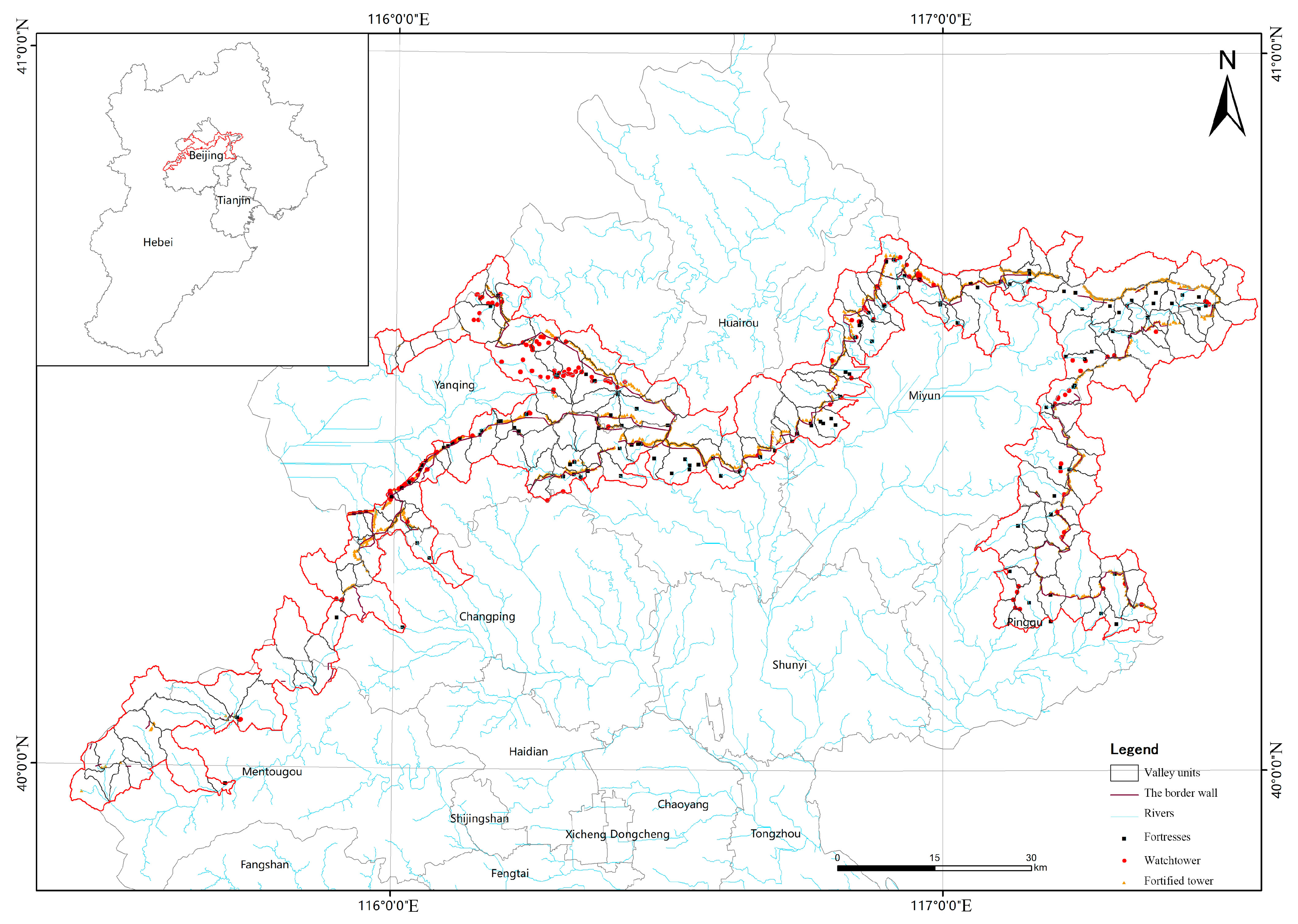
3.1. Study Area

The Great Wall Cultural Belt in northern Beijing, China, was used as the study area. In 1987, UNESCO recognized the Great Wall as a vital part of the world’s cultural heritage due to its historical, artistic, and scientific significance [41]. The range of the research area runs through the ecological conservation areas of northern Beijing distributed in six districts, namely Pinggu, Miyun, Huairou, Yanqing, Changping, and Mentougou, which comprise around 30% of the metropolitan area and are home to over 680,000 people. The term ‘valley’ refers to the closed belt-shaped area bounded by a watershed, which is formed by the combination of different slopes within the valley, and it is also the spatial model of mountain economic development proposed on the basis of a basin combined with the ecological protection, rural development, and cultural inheritance in mountainous areas [42]. Using GIS and topographic maps, the Beijing Great Wall Cultural Belt is divided into 169 valley units according to the needs of integrity and management. The size of the research area is 3186.48 km2, as indicated in Figure 1.
In recent years, China’s “constructing a national cultural park” policy has promoted the development of the Beijing Great Wall Cultural Belt. However, natural factors and heritage protection policy limit the study area, and there are development-based problems, such as population decline and unequal economic growth. This study assesses the SDS of the study area, and the results can serve as a basis for decision-making regarding heritage conservation and management in the area, which has significant theoretical and practical implications in terms of enhancing the region’s sustainable development.

3.2. Data Source

The following data were collected for this study: Landscape dominance was computed using global land cover data with a 30-m spatial resolution from the Global Land Cover 2020 database (http://www.globalcover.com, accessed on 20 July 2022), which includes the land types found in the research area. Using two scenes (LC81230322020264LGN00, LC81240322020223LGN00) from Landsat-8 Operational Land Imager (OLI) photos, vegetation cover was extracted. The geospatial data cloud (https://www.gscloud.cn, accessed on 10 June 2022) offered a 30-m resolution digital elevation model (DEM) to perform slope extraction. Road and river data were obtained from OpenStreetMap (https://www.openstreetmap.org/, accessed on 12 June 2022). POI data used to construct the indicators were obtained from Baidu Maps (2020) [43]. Township data and population data were obtained from the Beijing 2020 Statistical Yearbook. Heritage and scenic spot evaluation data were collected from the Popular Review APP, Ma Hive APP, and Ctrip APP (2016–2021). The Great Wall heritage spatial data (fortified towers, watchtowers, fortresses, border walls, and other heritage data) were obtained from the State Administration of Cultural Heritage of China.

3.3. Assessing Indicators of Sustainable Development Suitability

3.3.1. Establishment of the Index System

Establishing a complete set of comprehensive assessment index systems is one of the most crucial steps in the assessment of the SDS of the LCH [9]. The indicators selected to perform SDS assessment should reflect the unique characteristics of the development status of the Beijing Great Wall Cultural Belt and provide a comprehensive and accurate assessment of the suitability of the study area. Therefore, this study constructed a comprehensive assessment index system to determine SDS in the Beijing Great Wall Cultural Belt by selecting 15 indicators (Table 1) from three dimensions, namely ecological, cultural, and socio-economic, based on the principles of SDG 8, SDG 11, and SDG 15. As many indicators may result in redundancy, only highly representative indicators were chosen.
The ecological criterion layer (E) was established from SDG15, which consisted of five indicators: elevation, slope, vegetation cover, landscape dominance, and distance from the river [10,44,45]. This criteria layer shows the ecological state of the Beijing Great Wall Cultural Belt, which also represents the “environmental value” of the department to human society, demonstrating its vulnerability and dominance. It has beneficial and harmful effects on the Great Wall region’s sustainable development and preservation.
The cultural dimensions indicators used to evaluate the Great Wall region’s development were derived from SDG11 and included four indicators: heritage distribution density, mixing degree of heritage sites, grade of tourist attractions, and tourist attraction density [5,46]. This criteria layer depicted the Great Wall region’s distinctive cultural qualities and singularity due to its long-term historical evolution. It focuses on distributing heritage sites and scenic areas along the Beijing Great Wall Cultural Belt.
The socio-economic dimension indicators used to evaluate the development of the Great Wall region were derived from SDG8 and consisted of six indicators: population density, road network density, mixing degree of interest points, distance from main residential areas, infrastructure resource density, and service facility resource density [47,48]. This criteria layer focused on the influence of the Great Wall region’s history on the local community and its economic driving effect, as measured based on regional economic growth and residential prosperity.

3.3.2. Determining the Weight of Each Criterion via AHP Techniques

This study used AHP to calculate indicator weights, which represent one of the most extensively used multi-criteria decision-making approaches and were developed in the 1970s by operations research specialist Saaty [49]. The AHP method allows decision makers to compare social, ecological, and economic factors [34]. The decision maker must complete a pairwise evaluation to rank these criteria between 1 and 9 to determine the relative weight [50]. Four steps comprise the AHP:
1.
Decomposing a decision issue and building a hierarchical model of criteria and decision alternatives;
2.
Pairwise comparison between criteria and vectorization of weights;
3.
Pairwise comparison between decision alternatives on each criterion and the production of local weight vectors;
4.
Determining the vector of global preferences of choice variations sorted by their contributions to the final decision problem’s goal [36,49].
When the findings indicated that the departure from consistency could be described by the consistency index (CI), it was calculated as shown in Formula (1):
C R = λ m a x n / ( n 1 )
λ m a x is the maximum eigenvalue available when the number of assessment indicators is n. The consistency ratio (CR) is the ratio of CI to the average random index of the matrix of the same order, and it is used to check the consistency of the judgment matrix. The weighing mechanism is deemed appropriate when CR is less than 0.1 [33,34].
In this study, nine heritage conservation and urban planning experts rated the weights of the assessment indicators. They analyzed these weights via a two-by-two comparison using the AHP, reducing the difficulty of comparing different natural factors and increasing accuracy. Each indicator’s weight in this study was determined via a synthesis of the findings of nine specialists. Table 1 displays the indicator weights. W i was calculated via the AHP method, and all consistency ratios fell below 0.07, which was considered to be acceptable.

3.3.3. Calculating the Sustainable Development Suitability Index

This study calculates the sustainable development suitability index (SDSI) using the composite index method, which is a method for converting indicators of various scales into a standard form, and the values are referred to as the “composite index” [9]. In this study, a weighted linear combination method was used to evaluate the SDSI by multiplying the weights of the evaluation indicators derived from the AHP by the rating model before calculating the sum of the multiplied values of the evaluation indicators to determine the SDSI. According to the rating model in Table 2, all indicators were reclassified into five levels (1, 2, 3, 4, and 5: low, lower, medium, higher, and high).
The calculation of the sustainable development suitability index was performed as shown in Formula (2):
S D S I = i = 1 n W i P ( x i )
where SDSI is the sustainable development suitability index representing the level of sustainable development suitability, W i is the weight of each indicator, P ( x i ) is the standardized value of each indicator, and i is the total number of indicator items.

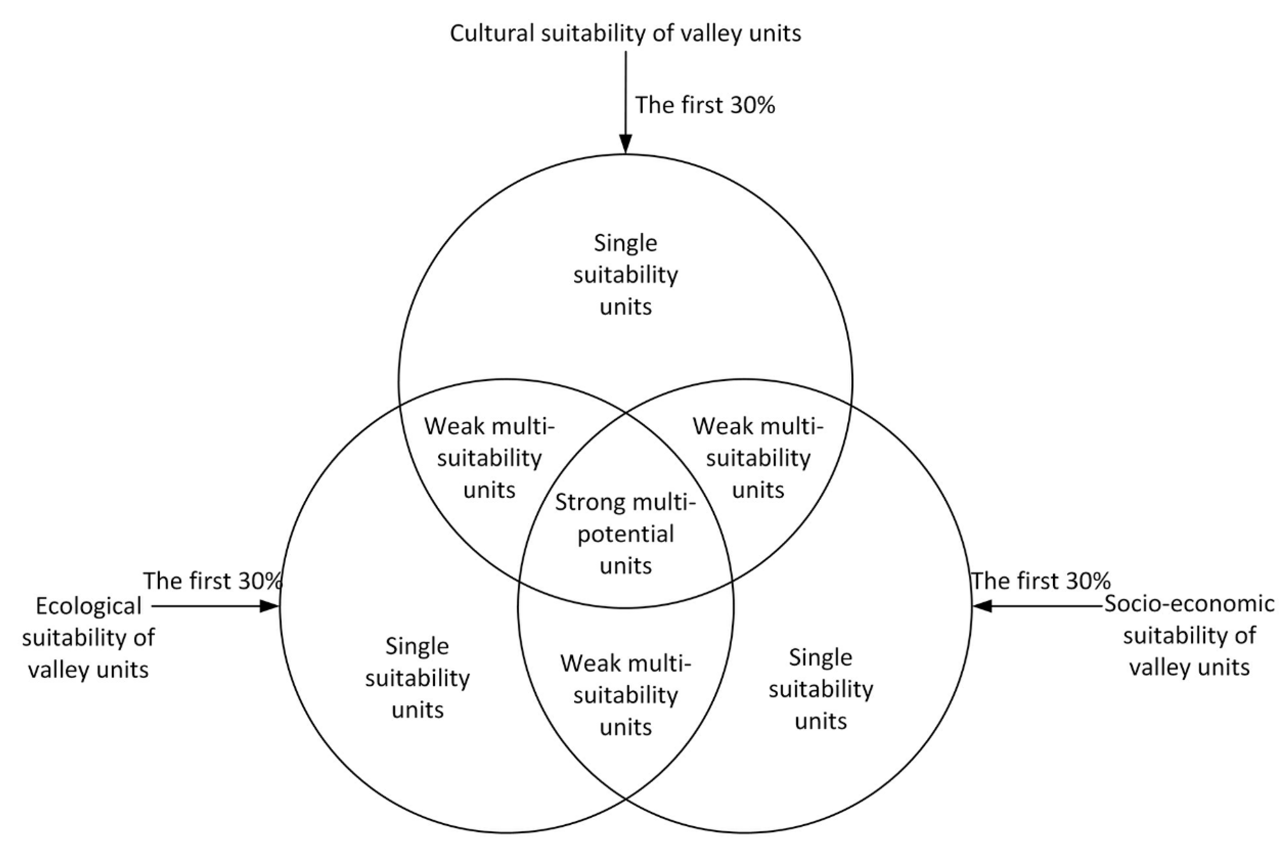
3.4. Development Suitability Type Assessment of the Valley Units

The research into the SDS types in the study region focused on the interaction between each dimension’s integrated suitability and development potential. Although it included the concept of suitable integration, there were systematic trade-offs between many elements, and the simple superposition of weights obscured the features of each dimension of development suitability [37,51]. This study utilized the triangle graphical method to evaluate the combined proportions of ecological, cultural, and socio-economic compatibility against the weighted overlaid findings, instead of the clustering method often employed, to make assessment results more intuitive and understandable. This method provides precise and significant information that is neglected by the indices of the indicators, resulting in more scientific conclusions being presented to assess the suitability types of the Great Wall region’s units.
The triangle graphical method establishes a reference system using the quantitative range of the three components as the coordinates of an equilateral triangle [52]. Specifically, the ecological, cultural, and socio-economic suitability of Great Wall region’s units were utilized as coordinates, with the values of each dimension being proportionally organized along one side of the triangle. Three parallel straight lines were positioned at the junction points of the triangle in proportions of 25% and 75%, respectively. As a result, seven distinct sustainable development suitability type zones were classified in the triangle chart (as shown in Figure 2).

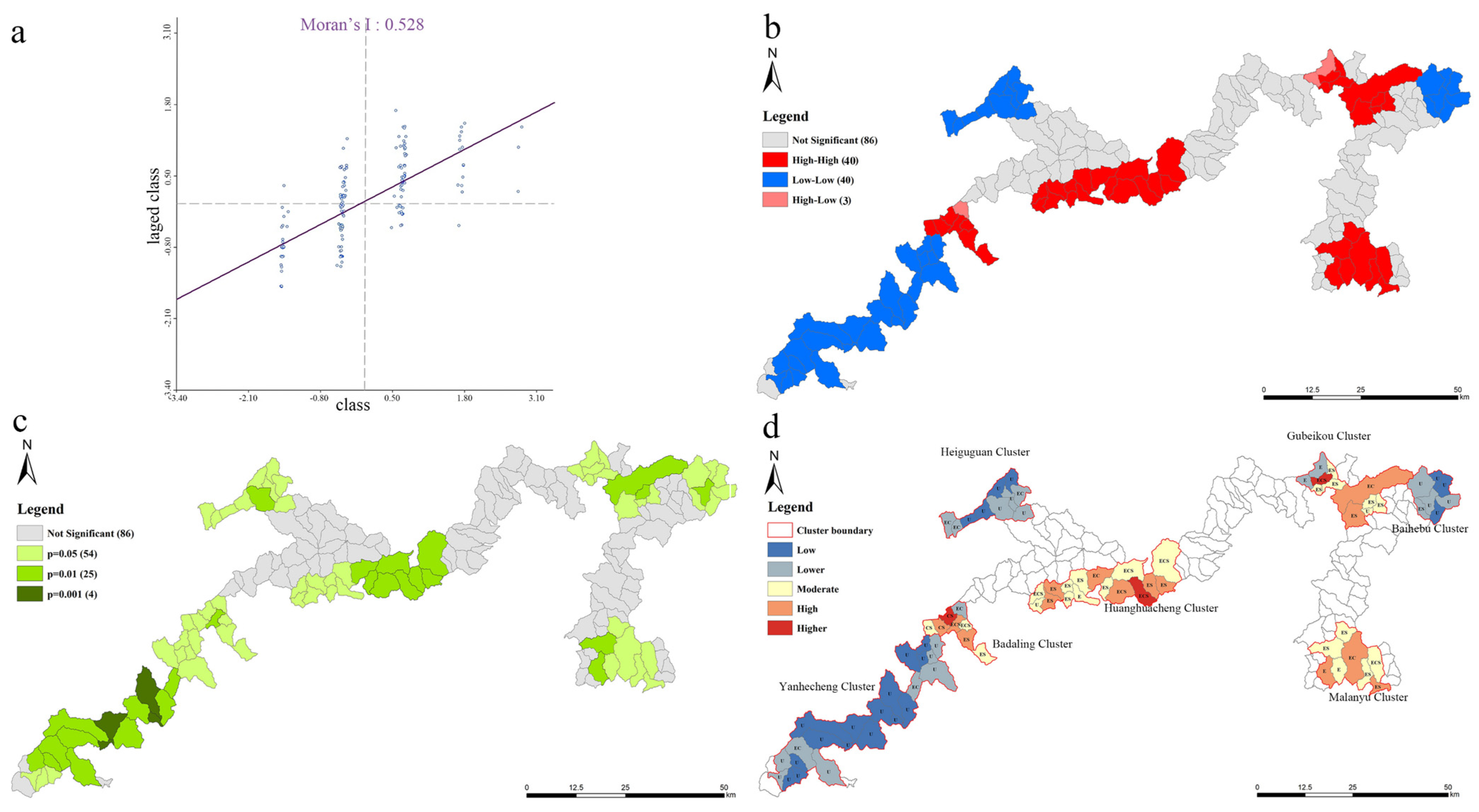
3.5. Spatial Autocorrelation Analysis Used to Assess Development Suitability

Geographical autocorrelation quantifies the significance of the association between the values of variables depending on their spatial arrangement [53,54]. This study measured the characteristic relationships between feature locations and values by calculating the global spatial autocorrelation and the local spatial association indicator (LISA) for the development suitability of the research area, using GeoDa software to determine the relationships between all of the indicators used [55,56].
Moran’s I is a correlation coefficient that measures the overall spatial autocorrelation of a dataset by determining the degree to which an object is statistically similar to other nearby objects and can be used to determine the spatial aggregation of valley units’ suitability scores throughout the study area. LISA may measure the degree of correlation between the properties of units and their neighbors throughout an area, hence facilitating the identification of local spatial clustering patterns and spatial outliers. In this study, the Moran scatter plot and the LISA clustering map enable the identification of the spatial aggregation types (H-H, L-H, L-L, and H-L) and the cell placements in the valley units. Using local spatial clustering, the Moran scatter plot classifies the sustainable development suitability of the units into four categories: consolidating area (H-H), strengthening area (L-H), promoting area (L-L), and driving area (H-L) [57,58].

4. Results and Discussion

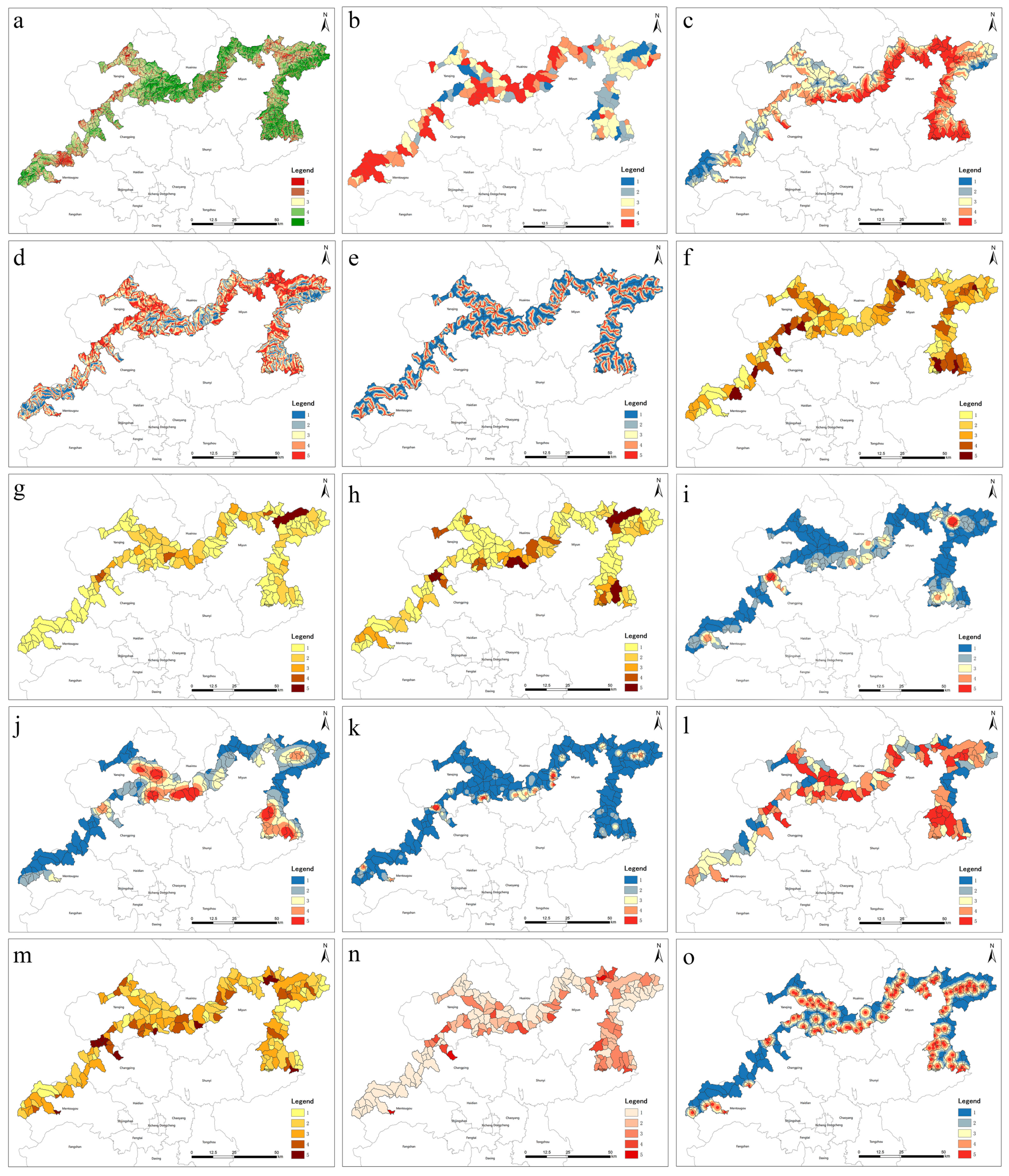
4.1. Distribution of Sustainable Development Suitability in the Beijing Great Wall Cultural Belt

The results of the assessment of the ecological, cultural, socio-economic, and comprehensive sustainable development suitability of the Beijing Great Wall Cultural Belt are shown in Figure 3 (the calculated results of each index are shown in Appendix A). Regarding single development suitability, the ecological development suitability dimension has a low distribution tendency in the west and a high distribution tendency in the east (Figure 3a). The western section of the Beijing Great Wall Cultural Belt is more environmentally vulnerable than the eastern section, which has high ecological development suitability. The valley regions with poor ecological suitability account for 15.3% of the total area, and they are typically more balanced. On the other hand, the socio-economic and cultural suitability demonstrate apparent regional differences and a significant degree of overlap, with 11.8% of valley units having high socio-economic suitability and 4.6% of valley units having high cultural suitability (Figure 3b,c). The Great Wall is located in the outer urban area of Beijing, and there are apparent differences between the distribution of cultural resources and uneven economic development [59].
Figure 3d shows that the regions with the highest sustainability suitability values are Yanqing, Huairou and Miyun, and Pinggu, while Changping and Mentougou have lower ratings. The poor development suitability regions included the bulk of the research area, were mainly located in the west and east, and were distributed in Mentougou, Changping, Yanqing, and Miyun; there were a total of 97 valley units, representing 63% of the total area. The moderate and high development suitability areas were concentrated in the central and eastern regions of the research area, namely Yanqing, Huairou, Miyun, and Pinggu, which had 72 valley units.
Along the Beijing Great Wall Cultural Belt, the suitability for sustainable development is variably distributed due to various influences. Strong development potential and competitive advantages characterize regions with high development suitability; poor quality resources, inadequate supporting facilities, and a low ecological carrying capacity characterize regions with low development suitability. The large-scale spatial attributes of LCH have caused many problems for the management, conservation, and sustainable development, such as the loss of thematic characteristics due to the destruction and disappearance of local heritage, the lack of a unified management system to coordinate all kinds of management teams, and the convergent development patterns of villages along the routes that have cut off the historical veins.
Regarding the unbalanced development of the Great Wall region in Beijing, the following two suggestions are made: Inter-regional consultation—the construction of the Great Wall National Cultural Park should be based on a regional perspective, a comprehensive analysis of regional advantages, the strengthening of the spatial connection between the valley units, and the emphasizing of local characteristics for planning and layout. Intersectoral consultation—the planning, site selection, and construction activities of the Great Wall National Cultural Park necessitate a systematic and holistic consideration of cultural, ecological, and socio-economic factors. To enable systematic and comprehensive assessment factors, the travel residence, Forestry Bureau, and development and reform departments should consult to advance relevant work.

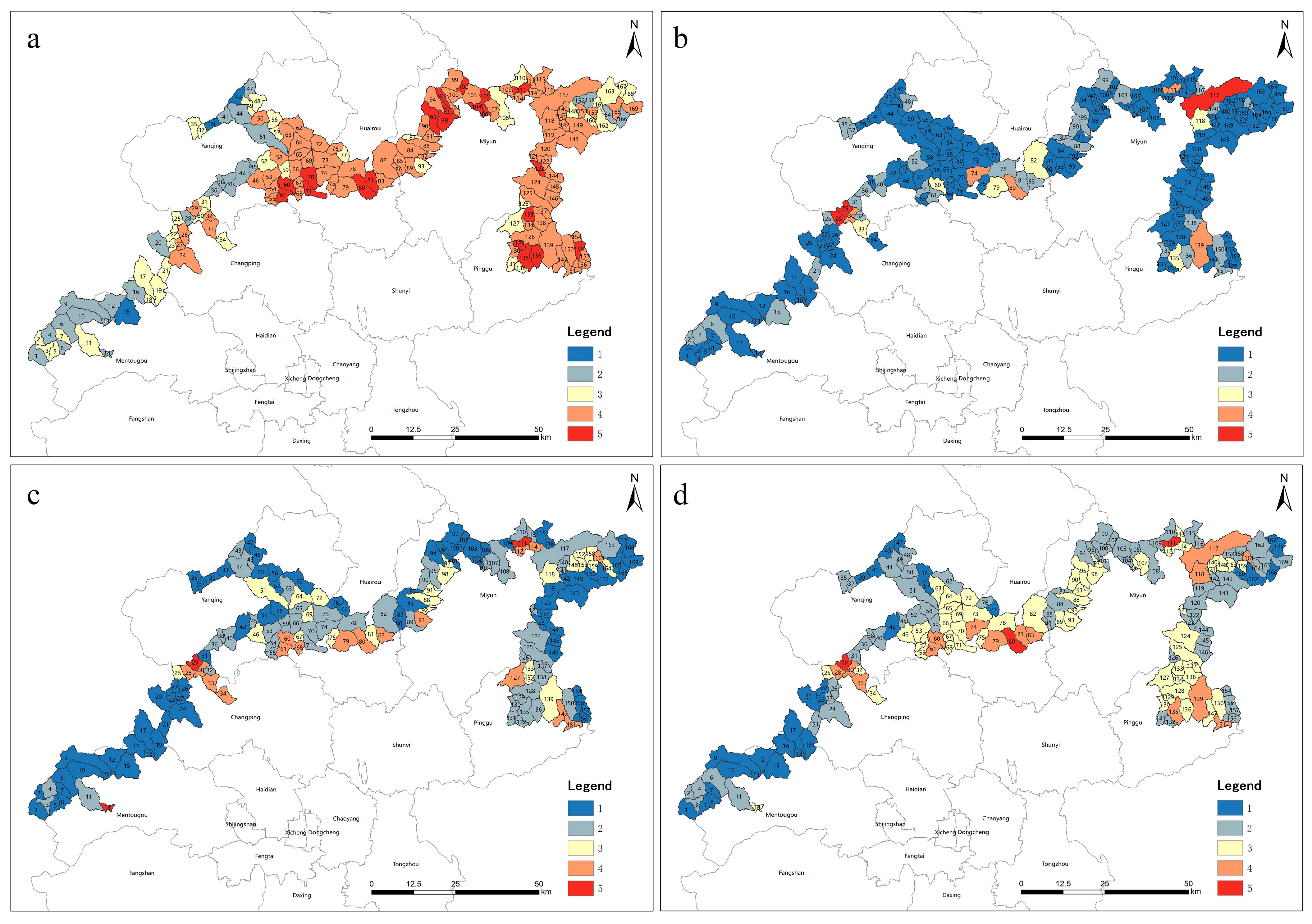
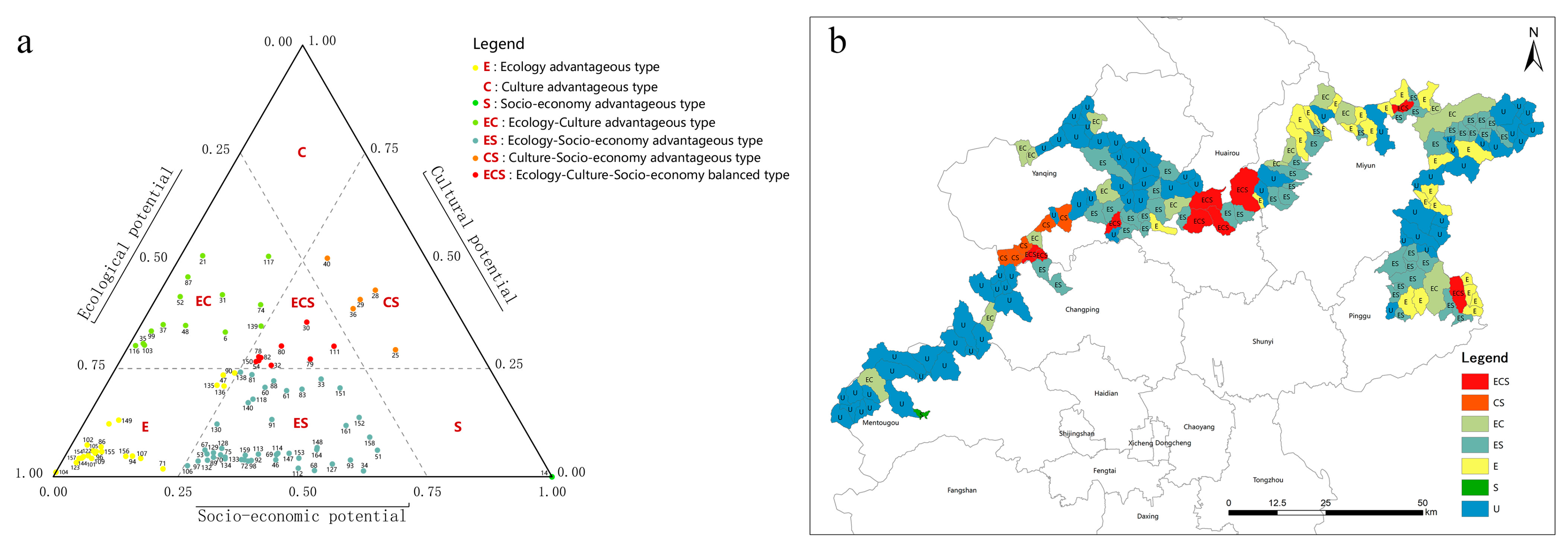
4.2. Zoning of Development Suitability Types in Beijing Great Wall Cultural Belt

To identify the internal differences in the wide suitability of the Beijing Great Wall Cultural Belt, the graphical triangle method was applied to classify the 96 valley units with different combinations of development suitability types; the remaining 73 units were non-dominant types. The percentages depicted as the coordinates of each side of the triangle have three orientations, as shown in Figure 4a. A total of seven suitability type combinations, namely ecologically advantageous (E), socio-economically advantageous (S), culturally advantageous (C), ecologically–socio-economically advantageous (ES), ecologically–culturally advantageous (EC), culturally–socio-economically advantageous (CS), and ecologically–culturally–socio-economically balanced (ECS), were constructed. The Beijing Great Wall Cultural belt valley units contained three primary potential types: ES (45), E (22), and EC (28). The remaining computed kinds were ECS (9), CS (5), and S (1). This finding indicates that the development suitability of the majority of valley areas varied internally in terms of type, with the majority of valley areas dominating the ecological suitability dimension and a minority of area dominating the socio-economic suitability dimension, reflecting the weaker economic strength of the outer urban area. The triangle graphical method further confirms this pattern of spatial polarization. At the same time, the figure reveals a grouping agglomeration relationship between the dominant valley units, indicating that the valleys have interacted with one another. The Beijing Great Wall Cultural Belt valley units have different spatial tendencies regarding development suitability. Therefore, it is essential to consider the differences in development suitability types when recommending development decisions. The results of the dominating valley area calculation are almost always the same as those of the comprehensive development suitability calculation, and 93.75% of the dominant valley areas are either single development units or total development units.
This study presents a detailed analysis of the development suitability types of each unit to examine the causes of the geographical divergence of numerous suitability types in the Beijing Great Wall Cultural Belt region. Strong overall suitability refers to the unit having ecological, cultural, and socio-economic benefits, which account for 5.3% of all units. Weakly integrated suitability refers to units with ecological, cultural, and socio-economic strengths, accounting for 46.2% of the total units, which are known together as integrated development suitability areas.
Based on the suitability types, we can deduce that the Beijing Great Wall Cultural Belt’s development suitability is primarily ecological in nature (Figure 4b). It is mainly concentrated in Yanqing, Huairou, Miyun, and Pinggu. The single ecological suitability accounts for 13%, but the complete suitability unit incorporates ecological aspects at 48.5%. From the standpoint of Great Wall heritage conservation and sustainable development, the Great Wall region features various ecological reserves suited to ecotourism development and offers exceptional ecological advantages. Integrated development areas dominate the socio-economic and cultural characteristics of the development suitability type of the valley, with geographical divergence and aggregation tendencies. Due to the development and construction of the Great Wall area in Beijing over the years, several famous and well-developed core areas, such as Badaling, Huanghuacheng, and Gubeikou, are essentially integrated development areas that emerged due to the differences in their cultural resources.
The above-mentioned investigation shows that the high composite and development suitability valleys considerably overlap, further verifying the polarized distribution judgment. The LCH not only possesses a large number of historical and cultural resources and natural landscape resources, but also includes a complete ecosystem formed by large-scale natural geographic units. Beijing is rich in resources along the Great Wall, but the resource advantages have not yet been transformed into development advantages, and most of the A-level scenic spots located along the Great Wall are fully loaded or even overloaded, with less consideration of the ecological and environmental capacities and the carrying capacity of cultural relics. The protection and development of linear heritage should be linked to the surrounding environment, resources, humanities, and other factors related to joint development while focusing on the protection of the surrounding natural environment and socio-economic coordination in order to achieve sustainable development.
Development recommendations are provided for the seven suitability types of Great Wall valleys identified via the triangle diagramming method: decision makers should respect the status quo regarding the polarized distribution of such resources and adopt different development goals and measures for different types of areas. Specifically, the EC type needs to develop a tourism model that combines ecology and culture, since it combines ecology and its own heritage resources. The ES type is not rich in cultural resources, meaning that it is suitable for developing eco-tourism based on its basic service facilities and encouraging the balanced development of its ecology and economy. The CS type has a good economic base and strengthens ecological management based on enhanced protection and management of cultural heritage to solve problems such as soil erosion and ecological degradation. The ecological carrying capacity of E-type valley areas is still acceptable, but in the absence of a solid industrial foundation and resources, their development should be restricted until a suitable industry is introduced. The ECS type can rely on different types of cultural relics resources, promote the regional integration of cultural relics resources and centralized and continuous protection and utilization, and achieve regional synergistic development with the goal of driving the development of surrounding villages. In general, the linear heritage area is a whole, and each section should not unilaterally emphasize the importance of the section in which it is located, but should sort out the relevant elements in a hierarchical manner, break the previous protection concept of emphasizing the “single unit” and “single section”, set up the thinking of systematic protection, and formulate a targeted development strategy. The establishment of systematic protection enables the development of targeted strategies.

4.3. Spatial Characteristics of Sustainable Development Suitability in Beijing Great Wall Cultural Belt

Figure 5 depicts the results of the spatial autocorrelation analysis of the composite development suitability score using GeoDa and the Queen spatial weighting method. The global spatial autocorrelation Moran’s I was 0.528 > 0 (Figure 5a), indicating that the study area’s development suitability values exhibit solid spatial autocorrelations and spatial clustering. The valley units are distributed into four major categories in the figure. Most points are distributed in the first and third quadrants, indicating that high development suitability valley units surround high development suitability valley units. Low suitability units surround low suitability units. In other words, the developmental suitability of the valley in these regions has a strong positive correlation. The small number of points distributed in the second and fourth quadrants indicates that the high-suitability valley surrounds the low-suitability valley, and the low-suitability valley surrounds the high-suitability valley. It also shows that the development suitability of these valleys is negatively correlated.
As shown in Figure 5b, 24.8% of the valley units are H-H aggregations distributed in Changping, Yanqing, Huairou, Miyun, and Pinggu. In comparison, 23.6% are L-L aggregations, which are primarily distributed in Mentougou, Changping, Yanqing, and Miyun. In addition, 0.18% of the units are H-L aggregations. Seven significant clusters can be derived by combining the valley suitability scores (Figure 5d) with high–high (H-H) aggregations dominated by the Badaling Cluster, Huanghuacheng Cluster, Gubeikou Cluster, and Malanyu Cluster; these clusters are valued consolidation areas. In the context of the sustainable development of heritage and the construction of national cultural parks, they should continue to maintain their high level of development while driving the growth of the surrounding areas. The Yanhecheng Cluster, Baihebao Cluster, and Heihuguan Cluster show low–low (L-L) aggregations and are areas in which value is enhanced. These areas are relatively uncoordinated in terms of SDS, and appropriate policies and measures may bring significant improvements to this relationship. China’s cultural heritage protection and development resources come from a single source, which is basically dominated by policy and financial allocations. For such areas with a low level of development appropriateness, on one hand, an industrial access system can be implemented to help shift their industrial development to a tourism-driven model; on the other hand, the participation of social forces can be strengthened, allowing more organizations and individuals to become involved in economic development.
The spatial statistical analysis (Figure 5c) demonstrates that the significance level approaches 5% in most valley regions with solid clustering of suitability scores and 1% in the remaining valley regions. The clusters with significant correlations are relatively evenly distributed across the six districts in which the Great Wall is located. The Yanhecheng cluster is the largest and least grouped cluster. This fact is true because this area is located in a mountainous region lacking industrialization and cultural resources. The significance level is also minor in regions in which the aggregation is insignificant. Priority can be given when making development decisions in the Great Wall region to areas with high spatial autocorrelation, which are both highly efficient and enable better and more effective development.
Overall, spatial autocorrelation more precisely identifies development-friendly areas. The development suitability of the Beijing Great Wall Cultural Belt area is primarily characterized by the clustering of H-H and L-L, indicating that the Beijing Great Wall Cultural Belt is composed of areas in varying development states and degrees of development. Therefore, the connection between clusters must be strengthened, and decisions must be made with groups in mind. For instance, Badaling Cluster is currently one of the most developed regions of the Beijing Great Wall Cultural Belt’s economy. Although the Great Wall region’s resources have driven its development, its ecological carrying capacity is no longer sufficient to support its excessive development. Development action should be limited, with ecological conservation taking precedence. As for the Yanhecheng group, which is a potential enhancement area, there are still EC units within it; these units can serve as the group’s development priority pole and drive the development of the surrounding units.

5. Conclusions

In this study, we used AHP to construct an evaluation system comprising cultural, ecological, and socio-economic dimensions to determine the suitability of the Beijing Great Wall Cultural Belt of for sustainable development, identified the types of valley development suitability through triangle diagrams, and employed spatial autocorrelation analyses to study the hot and cold distributions and spatial clustering patterns in the region. Integrating statistical, remote sensing, and GIS information data enhanced the precision, objectivity, and dependability of research outcomes. The results indicate the following outcomes:
1.
There is a discernible polarization in terms of the level of suitability for sustainable development. The distribution of ecological suitability is low in the west and high in the east. In contrast, high cultural and socio-economic suitability values are distributed in a point pattern and exhibit a synergistic phenomenon.
2.
Along the Beijing Great Wall Cultural Belt, the valley units have development suitability patterns. Most valleys have single or multiple ecological advantages, and the ecological suitability and carrying capacity along the Great Wall are high.
3.
The spatial autocorrelation analysis reveals seven clusters in the valley area: Badaling Cluster, Huanghuacheng Cluster, Gubeikou Cluster, and Malanyu Cluster as heated spots; Yanhecheng Cluster, Hegukguan Cluster, and Baihedao Cluster as cold spots. Sustainable development should rely on clusters with exceptional advantages to motivate the surrounding areas to synergistically develop and prevent the overdevelopment of individual clusters to achieve more efficient outcomes.
In conclusion, the magnitude and spatial distribution of development adaptations in the Beijing Great Wall Cultural Belt, as well as complementary approaches, should be proposed to develop relevant regulations. It is essential to observe that this study has the following limitations:
Even though the hierarchical analysis method was used to modify the weights during the construction of the LCH sustainable development suitability assessment index system, the expert scoring method retains some subjectivity. In future research, making adjustments based on the actual circumstance will be necessary. In addition, based on the validation of additional cases, the construction of the index system must be revised due to the complexity of LCH’s sustainable development.

Author Contributions

Conceptualization, D.H.; methodology, J.H.; software, J.H.; validation, D.H. and J.Z.; formal analysis, J.H.; investigation, J.H.; resources, J.Z.; data curation, J.H.; writing—original draft preparation, J.H.; writing—review and editing, D.H. and J.Z.; visualization, J.H.; supervision, D.H.; project administration, D.H. and J.Z.; funding acquisition, J.Z. All authors have read and agreed to the published version of the manuscript.

Funding

This research was funded by China National Natural Science Foundation, Chair: Jie Zhang (grant no. 52178029), Chair: Ding He. (grant no. 52378002, 51808022), the Municipal Education Commission of Beijing, Chair: Ding He. (KM202210026014), Beijing Energy Conservation & Sustainable Urban and Rural Development Provincial and Ministry Co-construction Collaboration Innovation Center and Beijing Key Laboratory of Green Building and Energy-efficiency Technology.

Data Availability Statement

The data in this study are available from the corresponding authors upon request. Due to the sensitivity of the study area, some data cannot be made public.

Acknowledgments

We appreciate the constructive comments and suggestions provided by the reviewers, which helped us to improve the quality of this manuscript. We also would like to offer our sincere thanks to those who participated in the data processing and manuscript revision stages.

Conflicts of Interest

The authors declare no conflict of interest.

Appendix A

Figure A1. Ranking of suitability indicator based on the following factors: (a) vegetation coverage; (b) landscape dominance; (c) distance from the river; (d) elevation; (e) slope; (f) heritage distribution density; (g) mixing degree of heritage sites; (h) grade of tourist attractions; (i) tourist attractions density; (j) population density; (k) road network density; (l) mixing degree of interest points; (m) distance from main residential areas; (n) infrastructure resource density; (o) service facility resource density.
Land 12 01761 g0a1

References

  1. Wu, Z.; Ma, J.; Zhang, H. Spatial Reconstruction and Cultural Practice of Linear Cultural Heritage: A Case Study of Meiguan Historical Trail, Guangdong, China. Buildings 2022, 13, 105. [Google Scholar]
  2. Oikonomopoulou, E.; Delegou, E.T.; Sayas, J.; Moropoulou, A. An innovative approach to the protection of cultural heritage: The case of cultural routes in Chios Island, Greece. J. Archaeol. Sci. Rep. 2017, 14, 742–757. [Google Scholar]
  3. Chen, Y.; Dang, A.; Peng, X. Building a cultural heritage corridor based on geodesign theory and methodology. J. Urban Manag. 2014, 3, 97–112. [Google Scholar]
  4. Li, H.; Jing, J.; Fan, H.; Li, Y.; Liu, Y.; Ren, J. Identifying cultural heritage corridors for preservation through multidimensional network connectivity analysis—A case study of the ancient Tea-Horse Road in Simao, China. Landsc. Res. 2021, 46, 96–115. [Google Scholar]
  5. Zhang, S.; Liu, J.; Pei, T.; Chan, C.-S.; Wang, M.; Meng, B. Tourism value assessment of linear cultural heritage: The case of the Beijing–Hangzhou Grand Canal in China. Curr. Issues Tour. 2023, 26, 47–69. [Google Scholar]
  6. Jiang, P.; Shao, L.; Baas, C. Interpretation of value advantage and sustainable tourism development for railway heritage in China Based on the analytic hierarchy process. Sustainability 2019, 11, 6492. [Google Scholar]
  7. Li, L.; Feng, R.; Xi, J. Ecological risk assessment and protection zone identification for linear cultural heritage: A case study of the Ming Great Wall. Int. J. Environ. Res. Public Health 2021, 18, 11605. [Google Scholar] [PubMed]
  8. Vecco, M.; Srakar, A. The unbearable sustainability of cultural heritage: An attempt to create an index of cultural heritage sustainability in conflict and war regions. J. Cult. Herit. 2018, 33, 293–302. [Google Scholar]
  9. Bamrungkhul, S.; Tanaka, T. The assessment of land suitability for urban development in the anticipated rapid urbanization area from the Belt and Road Initiative: A case study of Nong Khai City, Thailand. Sustain. Cities Soc. 2022, 83, 103988. [Google Scholar]
  10. Akbari, M.; Neamatollahi, E.; Neamatollahi, P. Evaluating land suitability for spatial planning in arid regions of eastern Iran using fuzzy logic and multi-criteria analysis. Ecol. Indic. 2019, 98, 587–598. [Google Scholar]
  11. Boley, B.B.; Johnson Gaither, C. Exploring empowerment within the Gullah Geechee cultural heritage corridor: Implications for heritage tourism development in the Lowcountry. J. Herit. Tour. 2016, 11, 155–176. [Google Scholar]
  12. Zheng, D.; Liang, Z.; Ritchie, B.W. Residents’ social dilemma in sustainable heritage tourism: The role of social emotion, efficacy beliefs and temporal concerns. J. Sustain. Tour. 2020, 28, 1782–1804. [Google Scholar]
  13. Ristić, D.; Vukoičić, D.; Nikolić, M.; Božović, S.; Milinčić, M. Tourism value assessment model of ‘UNESCO-listed’monasteries: Kosovo and Metohija. Curr. Issues Tour. 2020, 23, 2098–2102. [Google Scholar]
  14. Yang, J.; You, Y.; Ye, X.; Lin, J. Cultural heritage sites risk assessment based on RS and GIS—Takes the Fortified Manors of Yongtai as an example. Int. J. Disaster Risk Reduct. 2023, 88, 103593. [Google Scholar]
  15. Calgaro, E.; Lloyd, K.; Dominey-Howes, D. From vulnerability to transformation: A framework for assessing the vulnerability and resilience of tourism destinations. J. Sustain. Tour. 2014, 22, 341–360. [Google Scholar]
  16. Hu, H.; Qiao, X.; Yang, Y.; Zhang, L. Developing a resilience evaluation index for cultural heritage site: Case study of Jiangwan Town in China. Asia Pac. J. Tour. Res. 2021, 26, 15–29. [Google Scholar]
  17. Niu, S.; Lau, S.S.Y.; Shen, Z.; Lau, S.S.Y. Sustainability issues in the industrial heritage adaptive reuse: Rethinking culture-led urban regeneration through Chinese case studies. J. Hous. Built Environ. 2018, 33, 501–518. [Google Scholar]
  18. Cucco, P.; Maselli, G.; Nesticò, A.; Ribera, F. An evaluation model for adaptive reuse of cultural heritage in accordance with 2030 SDGs and European Quality Principles. J. Cult. Herit. 2023, 59, 202–216. [Google Scholar]
  19. Ost, C. Inclusive economic development in the urban heritage context. In World Heritage and Sustainable Development; Routledge: London, UK, 2018; pp. 53–67. [Google Scholar]
  20. Nicu, I.C. Cultural heritage assessment and vulnerability using Analytic Hierarchy Process and Geographic Information Systems (Valea Oii catchment, North-eastern Romania). An approach to historical maps. Int. J. Disaster Risk Reduct. 2016, 20, 103–111. [Google Scholar]
  21. Božić, S.; Tomić, N. Developing the Cultural Route Evaluation Model (CREM) and its application on the Trail of Roman Emperors, Serbia. Tour. Manag. Perspect. 2016, 17, 26–35. [Google Scholar] [CrossRef]
  22. Ferretti, V.; Comino, E. An integrated framework to assess complex cultural and natural heritage systems with Multi-Attribute Value Theory. J. Cult. Herit. 2015, 16, 688–697. [Google Scholar] [CrossRef]
  23. Li, F.; Zou, T. National Culture Park: Logical, origins and implications. Tour. Trib 2021, 36, 14–26. [Google Scholar]
  24. Mei, Y.; Yao, X.; Liu, X. Analysis on the Cognition of National Culture Park from the Perspective of Cultural Value: Reflections Based on the Practice of the Grand Canal National Culture Park. Mod. Urban Res. 2021, 7, 7–11. [Google Scholar]
  25. Kazemi, F.; Hosseinpour, N. GIS-based land-use suitability analysis for urban agriculture development based on pollution distributions. Land Use Policy 2022, 123, 106426. [Google Scholar] [CrossRef]
  26. Jayasooria, D. Sustainable development goals and social work: Opportunities and challenges for social work practice in Malaysia. J. Hum. Rights Soc. Work 2016, 1, 19–29. [Google Scholar] [CrossRef]
  27. Bassily, V.; Abufarag, T.; Goubran, S. Heritage Buildings’ Façades as Facilitators for Local Sustainable Development: The Case of Cairo’s El Korba Area. Heritage 2022, 5, 2689–2731. [Google Scholar] [CrossRef]
  28. Naheed, S.; Shooshtarian, S. The role of cultural heritage in promoting urban sustainability: A brief review. Land 2022, 11, 1508. [Google Scholar] [CrossRef]
  29. Guzman, P. Assessing the sustainable development of the historic urban landscape through local indicators. Lessons from a Mexican World Heritage City. J. Cult. Herit. 2020, 46, 320–327. [Google Scholar] [CrossRef]
  30. Della Spina, L. Adaptive sustainable reuse for cultural heritage: A multiple criteria decision aiding approach supporting urban development processes. Sustainability 2020, 12, 1363. [Google Scholar] [CrossRef]
  31. Lazar, N.; Chithra, K. A comprehensive literature review on development of Building Sustainability Assessment Systems. J. Build. Eng. 2020, 32, 101450. [Google Scholar] [CrossRef]
  32. Ma, H.; Li, S.; Chan, C.-S. Analytic Hierarchy Process (AHP)-based assessment of the value of non-World Heritage Tulou: A case study of Pinghe County, Fujian Province. Tour. Manag. Perspect. 2018, 26, 67–77. [Google Scholar] [CrossRef]
  33. Saaty, T.L. Decision making with the analytic hierarchy process. Int. J. Serv. Sci. 2008, 1, 83–98. [Google Scholar] [CrossRef]
  34. Awad, J.; Jung, C. Extracting the planning elements for sustainable urban regeneration in Dubai with AHP (analytic hierarchy process). Sustain. Cities Soc. 2022, 76, 103496. [Google Scholar] [CrossRef]
  35. Kittipongvises, S.; Phetrak, A.; Rattanapun, P.; Brundiers, K.; Buizer, J.L.; Melnick, R. AHP-GIS analysis for flood hazard assessment of the communities nearby the world heritage site on Ayutthaya Island, Thailand. Int. J. Disaster Risk Reduct. 2020, 48, 101612. [Google Scholar] [CrossRef]
  36. Zabihi, H.; Alizadeh, M.; Wolf, I.D.; Karami, M.; Ahmad, A.; Salamian, H. A GIS-based fuzzy-analytic hierarchy process (F-AHP) for ecotourism suitability decision making: A case study of Babol in Iran. Tour. Manag. Perspect. 2020, 36, 100726. [Google Scholar] [CrossRef]
  37. Peng, J.; Liu, Z.; Liu, Y.; Hu, X.; Wang, A. Multifunctionality assessment of urban agriculture in Beijing City, China. Sci. Total Environ. 2015, 537, 343–351. [Google Scholar] [CrossRef]
  38. Foroozesh, F.; Monavari, S.M.; Salmanmahiny, A.; Robati, M.; Rahimi, R. Assessment of sustainable urban development based on a hybrid decision-making approach: Group fuzzy BWM, AHP, and TOPSIS–GIS. Sustain. Cities Soc. 2022, 76, 103402. [Google Scholar] [CrossRef]
  39. Pinero, I.; San-Jose, J.T.; Rodriguez, P.; Losanez, M.M. Multi-criteria decision-making for grading the rehabilitation of heritage sites. Application in the historic center of La Habana. J. Cult. Herit. 2017, 26, 144–152. [Google Scholar] [CrossRef]
  40. Nadkarni, R.R.; Puthuvayi, B. A comprehensive literature review of Multi-Criteria Decision Making methods in heritage buildings. J. Build. Eng. 2020, 32, 101814. [Google Scholar] [CrossRef]
  41. Du, Y.; Chen, W.; Cui, K.; Zhang, K. Study on damage assessment of earthen sites of the Ming Great Wall in Qinghai Province based on Fuzzy-AHP and AHP-TOPSIS. Int. J. Archit. Herit. 2019, 14, 903–916. [Google Scholar] [CrossRef]
  42. Liu, C.; Liu, P. Probe into protecting and developing ancient villages while constructing valley economy in the mountainous areas of Beijing. Econ. Geogr. 2011, 31, 1923–1929. [Google Scholar]
  43. Shi, K.; Chang, Z.; Chen, Z.; Wu, J.; Yu, B. Identifying and evaluating poverty using multisource remote sensing and point of interest (POI) data: A case study of Chongqing, China. J. Clean. Prod. 2020, 255, 120245. [Google Scholar] [CrossRef]
  44. Huang, Y.; Shen, S.; Hu, W.; Li, Y.; Li, G. Construction of Cultural Heritage Tourism Corridor for the Dissemination of Historical Culture: A Case Study of Typical Mountainous Multi-Ethnic Area in China. Land 2022, 12, 138. [Google Scholar] [CrossRef]
  45. He, X.; Bo, Y.; Du, J.; Li, K.; Wang, H.; Zhao, Z. Landscape pattern analysis based on GIS technology and index analysis. Clust. Comput. 2019, 22, 5749–5762. [Google Scholar] [CrossRef]
  46. Božić, S.; Berić, D. Tourist Valorization of Cultural Route “The Trail of the Roman Emperors”. Eur. Res. 2013, 55, 1902–1913. [Google Scholar] [CrossRef]
  47. Moroke, T.; Schoeman, C.; Schoeman, I. Developing a neighbourhood sustainability assessment model: An approach to sustainable urban development. Sustain. Cities Soc. 2019, 48, 101433. [Google Scholar] [CrossRef]
  48. De Oliveira Cavalcanti, C.; Limont, M.; Dziedzic, M.; Fernandes, V. Sustainability assessment methodology of urban mobility projects. Land Use Policy 2017, 60, 334–342. [Google Scholar] [CrossRef]
  49. Saaty, T.L.; Vargas, L.G.; Saaty, T.L.; Vargas, L.G. The seven pillars of the analytic hierarchy process. In Models, Methods, Concepts & Applications of the Analytic Hierarchy Process; Springer: Berlin/Heidelberg, Germany, 2012; pp. 23–40. [Google Scholar]
  50. Morandi, D.T.; de Jesus França, L.C.; Menezes, E.S.; Machado, E.L.M.; da Silva, M.D.; Mucida, D.P. Delimitation of ecological corridors between conservation units in the Brazilian Cerrado using a GIS and AHP approach. Ecol. Indic. 2020, 115, 106440. [Google Scholar] [CrossRef]
  51. Pérez-Rodríguez, F.; Rojo-Alboreca, A. The triangle assessment method: A new procedure for eliciting expert judgement. Expert Syst. Appl. 2017, 72, 139–150. [Google Scholar] [CrossRef]
  52. Xu, F.-L.; Zhao, S.-S.; Dawson, R.W.; Hao, J.-Y.; Zhang, Y.; Tao, S. A triangle model for evaluating the sustainability status and trends of economic development. Ecol. Model. 2006, 195, 327–337. [Google Scholar] [CrossRef]
  53. Anselin, L.; Bera, A.K. Introduction to spatial econometrics. In Handbook of Applied Economic Statistics; CRC Press: Boca Raton, FL, USA, 1998; p. 237. [Google Scholar]
  54. Hu, X.; Ma, C.; Huang, P.; Guo, X. Ecological vulnerability assessment based on AHP-PSR method and analysis of its single parameter sensitivity and spatial autocorrelation for ecological protection–A case of Weifang City, China. Ecol. Indic. 2021, 125, 107464. [Google Scholar] [CrossRef]
  55. Yao, X.; Zeng, J.; Li, W. Spatial correlation characteristics of urbanization and land ecosystem service value in Wuhan Urban Agglomeration. Trans. Chin. Soc. Agric. Eng. 2015, 31, 249–256. [Google Scholar]
  56. Li, J.; He, J.; Liu, Y.; Wang, D.; Rafay, L.; Chen, C.; Hong, T.; Fan, H.; Lin, Y. Spatial autocorrelation analysis of multi-scale damaged vegetation in the Wenchuan earthquake-affected area, Southwest China. Forests 2019, 10, 195. [Google Scholar] [CrossRef]
  57. He, J.; Pan, Z.; Liu, D.; Guo, X. Exploring the regional differences of ecosystem health and its driving factors in China. Sci. Total Environ. 2019, 673, 553–564. [Google Scholar] [CrossRef]
  58. Wu, Z.; Zhang, F.; Di, D.; Wang, H. Study of spatial distribution characteristics of river eco-environmental values based on emergy-GeoDa method. Sci. Total Environ. 2022, 802, 149679. [Google Scholar] [CrossRef]
  59. Yang, Z.; Hao, P.; Cai, J. Economic clusters: A bridge between economic and spatial policies in the case of Beijing. Cities 2015, 42, 171–185. [Google Scholar] [CrossRef]
Figure 1. Location of the study area.
Land 12 01761 g001
Figure 2. The flowchart used to assess the valley development suitability of advantageous units.
Land 12 01761 g002
Figure 3. Integrated zoning map of development suitability grades in the Beijing Great Wall Cultural Belt: (a) ecological suitability; (b) cultural suitability; (c) socio-economic suitability; (d) integrated suitability.
Land 12 01761 g003
Figure 4. (a) Zoning of valley development suitability types; (b) Distribution of valley development suitability types in Beijing Great Wall Cultural Belt.
Land 12 01761 g004
Figure 5. Spatial distribution characteristic of the valley’s development suitability scores: (a) Moran scatter plot of spatial autocorrelation for the suitability scores; (b) Spatial agglomeration for the suitability scores; (c) Spatial autocorrelation significance for the suitability scores; (d) Spatial clustering of the 7 clusters.
Land 12 01761 g005
Table 1. The Beijing Great Wall Cultural Belt’s SDS assessment indicators and weights.
TargetCriteriaWeightIndicatorsIndex Weight ( W i )
Assessment index of sustainable development suitability (A)Ecological suitability (B1)0.2913Vegetation coverage (C1)0.0812
Landscape dominance (C2)0.0391
Distance from the river (C3)0.0492
Elevation (C4)0.0274
Slope (C5)0.0518
Cultural suitability (B2)0.3475Heritage distribution density (C6)0.1091
Mixing degree of heritage sites (C7)0.0299
Grade of tourist attractions (C8)0.1084
Tourist attractions density (C9)0.0704
Population density (C10)0.1186
Socio-economic
suitability (B3)
0.3611Road network density (C11)0.0462
Mixing degree of interest points (C12)0.0726
Distance from main residential areas (C13)0.0354
Infrastructure resource density (C14)0.0979
Service facility resource density (C15)0.0664
Table 2. Ranking of SDS indicators.
Very LowLowModerateHighVery High
Class12345
Vegetation coverage (%)0–0.180.18–0.470.47–0.700.7–0.900.90–1.0
Landscape dominance<2.172.17–3.113.11–3.633.63–3.87>3.87
Distance from the river (m)>1200800–1200500–800300–5000–300
Elevation (m)>16901280–1690880–1280480–88080–480
Slope (°)12.5–22.59.0–12.56.0–9.03.5–6.00–3.5
Heritage distribution density (PCs)0–67–1415–2324–35>35
Mixing degree of heritage sites0–0.140.14–0.470.47–0.700.70–0.900.90–1.0
Grade of tourist attractions 0–22–44–66–88–10
Tourist attractions density <0.120.12–0.600.60–1.51.5–2.58–10
Population density
(person/km2)
<4848–107107–195195–420>420
Road network density
(km/km2)
<0.160.16–0.480.48–0.80.8–1.4>1.4
Mixing degree of interest points <0.430.43–0.860.86–1.31.3–1.73>1.73
Distance from main residential areas (m)>40003000–40002000–30001000–2000<1000
Infrastructure resource density<0.250.25–0.650.65–1.141.14–1.65>1.65
Service facility resource density <0.070.07–0.260.26–0.550.55–0.96>0.96
Disclaimer/Publisher’s Note: The statements, opinions and data contained in all publications are solely those of the individual author(s) and contributor(s) and not of MDPI and/or the editor(s). MDPI and/or the editor(s) disclaim responsibility for any injury to people or property resulting from any ideas, methods, instructions or products referred to in the content.

