
Identification of Key Areas and Early-Warning Points for Ecological Protection and Restoration in the Yellow River Source Area Based on Ecological Security Pattern


Abstract
:1. Introduction
2. Materials and Methods
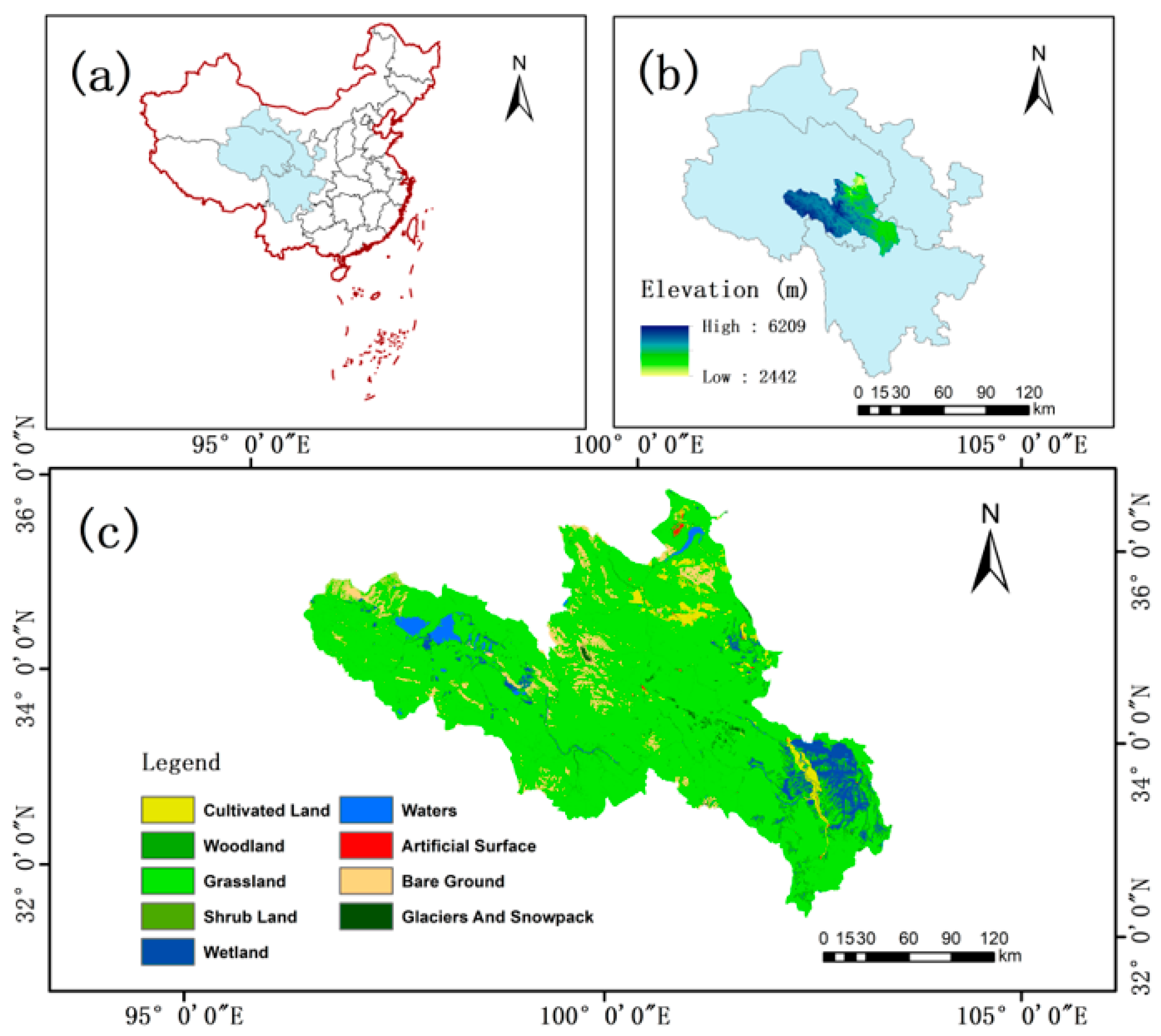
2.1. Study Area
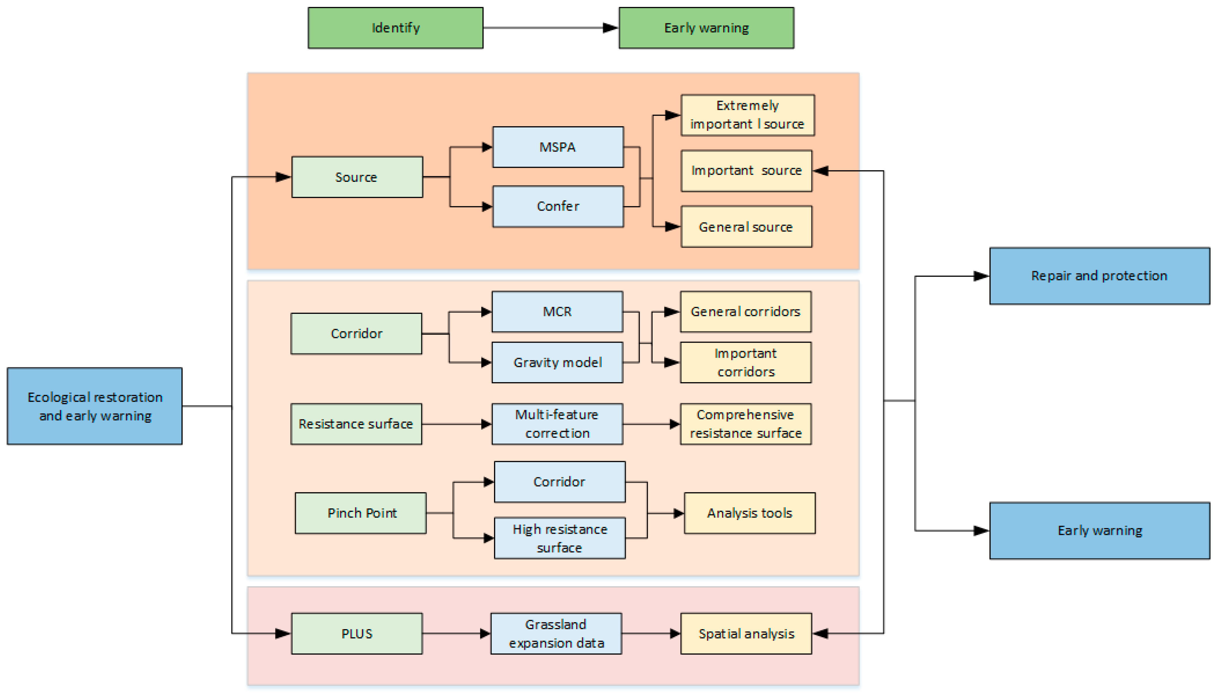
2.2. Research Framework and Data Sources
2.2.1. Land Cover and NDVI Data
2.2.2. Driving Factors
2.3. Ecological Source Area Identification Based on the MSPA Approach
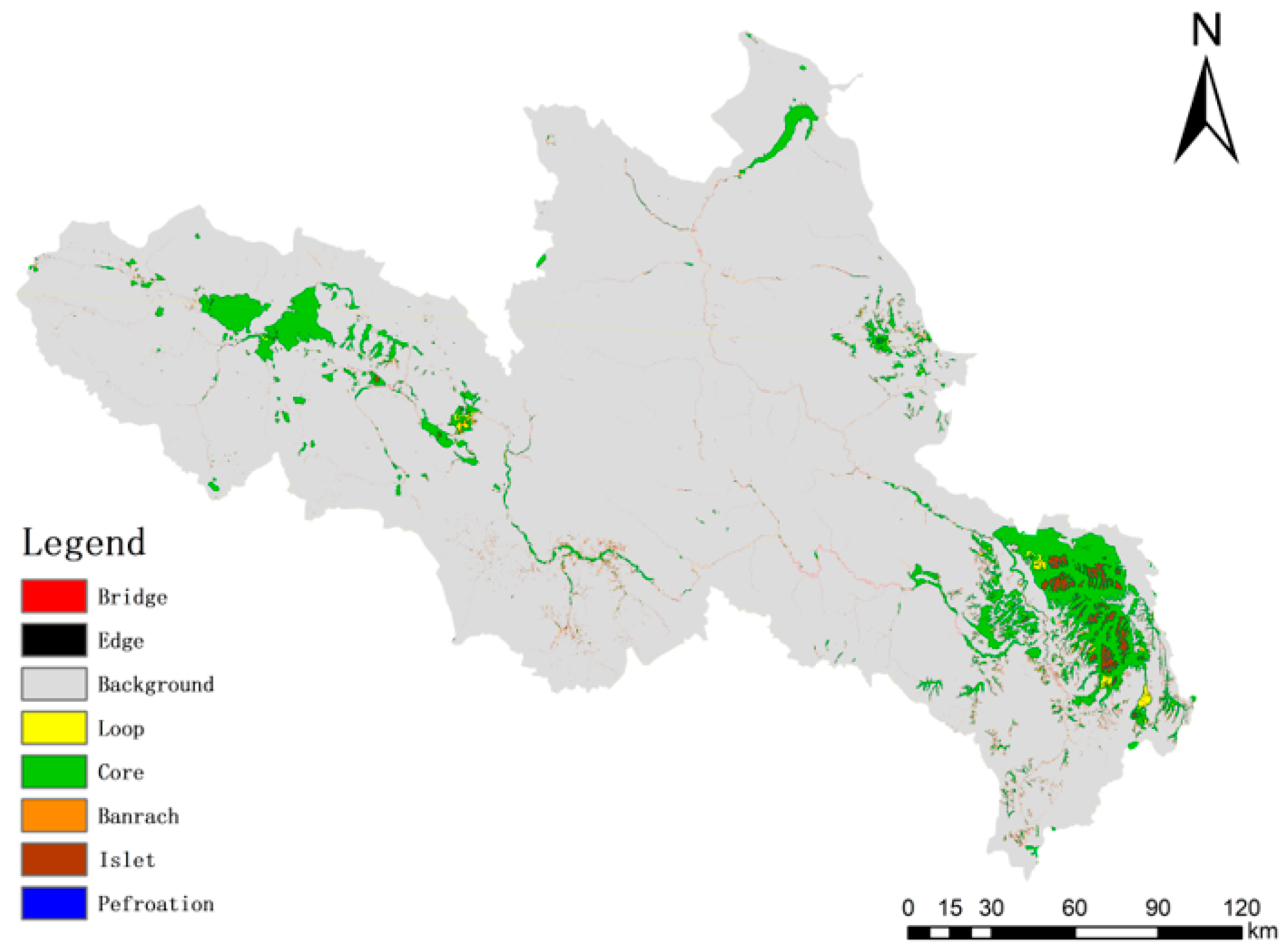
2.3.1. Landscape Pattern Analysis
2.3.2. Landscape Connectivity Evaluation
2.4. Extraction of Ecological Corridors Based on the Minimum Cumulative Resistance (MCR) Model
2.4.1. Resistance Surface Factor Selection
2.4.2. Confirmation of Resistance Values and Construction of Integrated Resistance
Surface
2.4.3. Extraction of Ecological Corridors Based on the Minimum Cumulative Resistance (MCR) Model
2.5. Simulation Analysis of Land Cover Change Based on the PLUS Model
2.5.1. PLUS Model
2.5.2. Kernel Density Analysis
3. Results
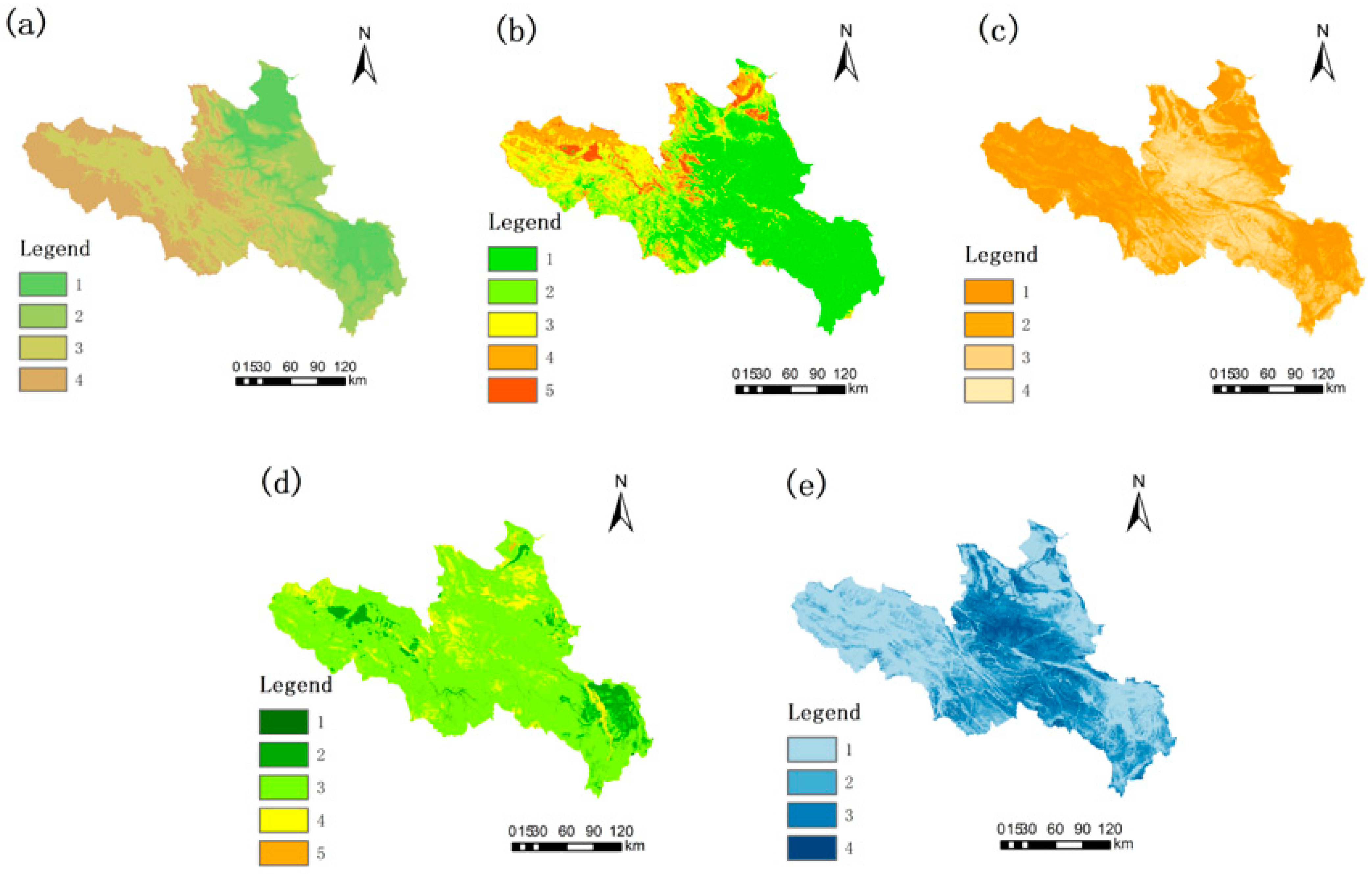
3.1. Landscape Pattern Analysis
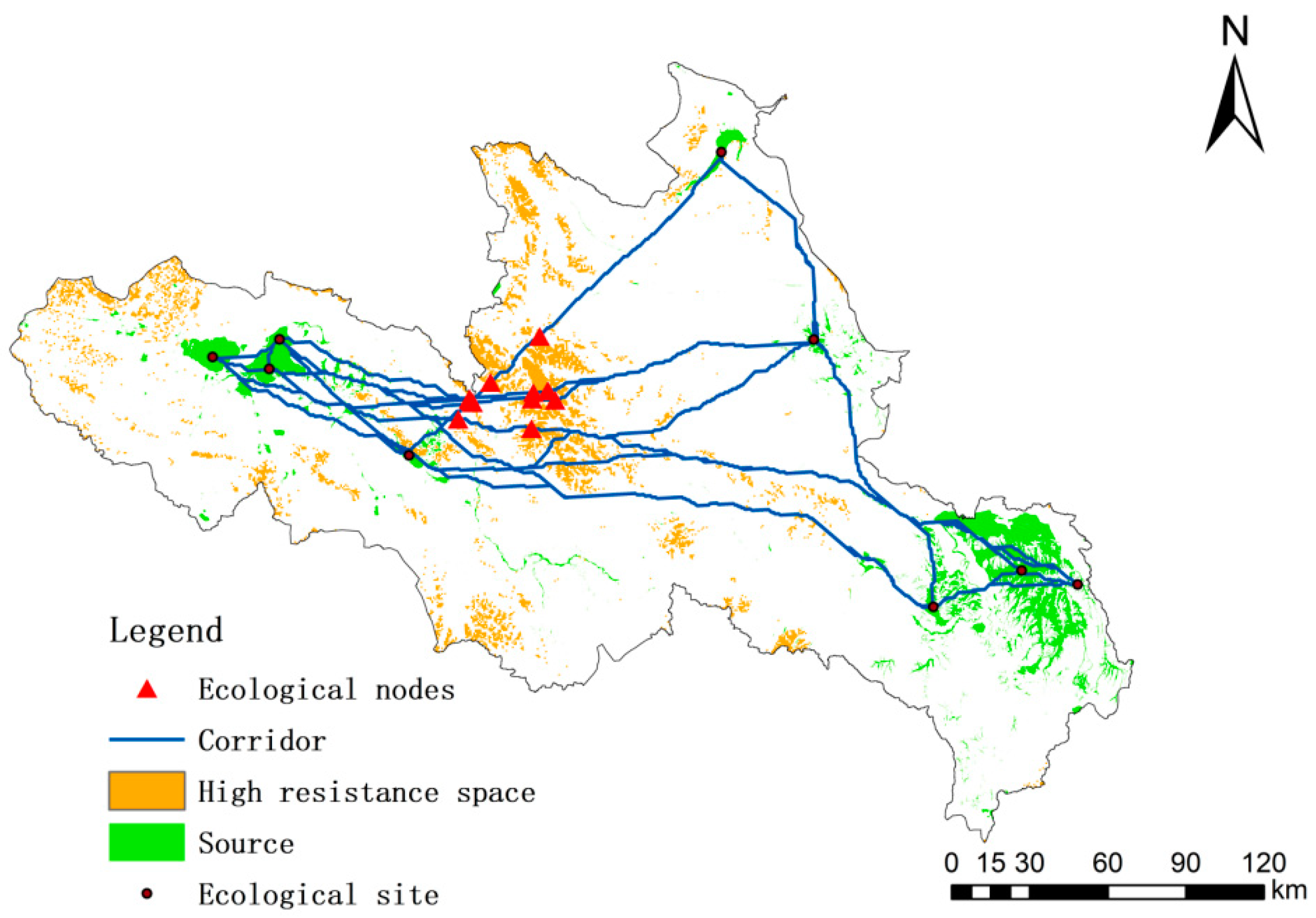
3.2. Ecological Network Construction
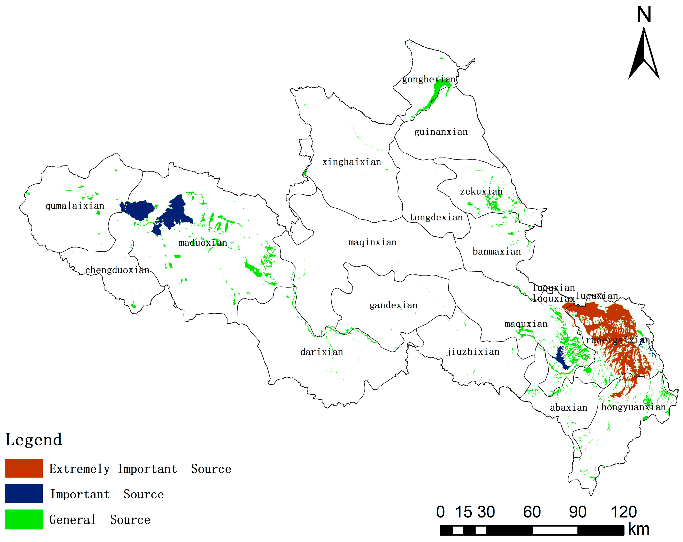
3.2.1. Ecological Source Area
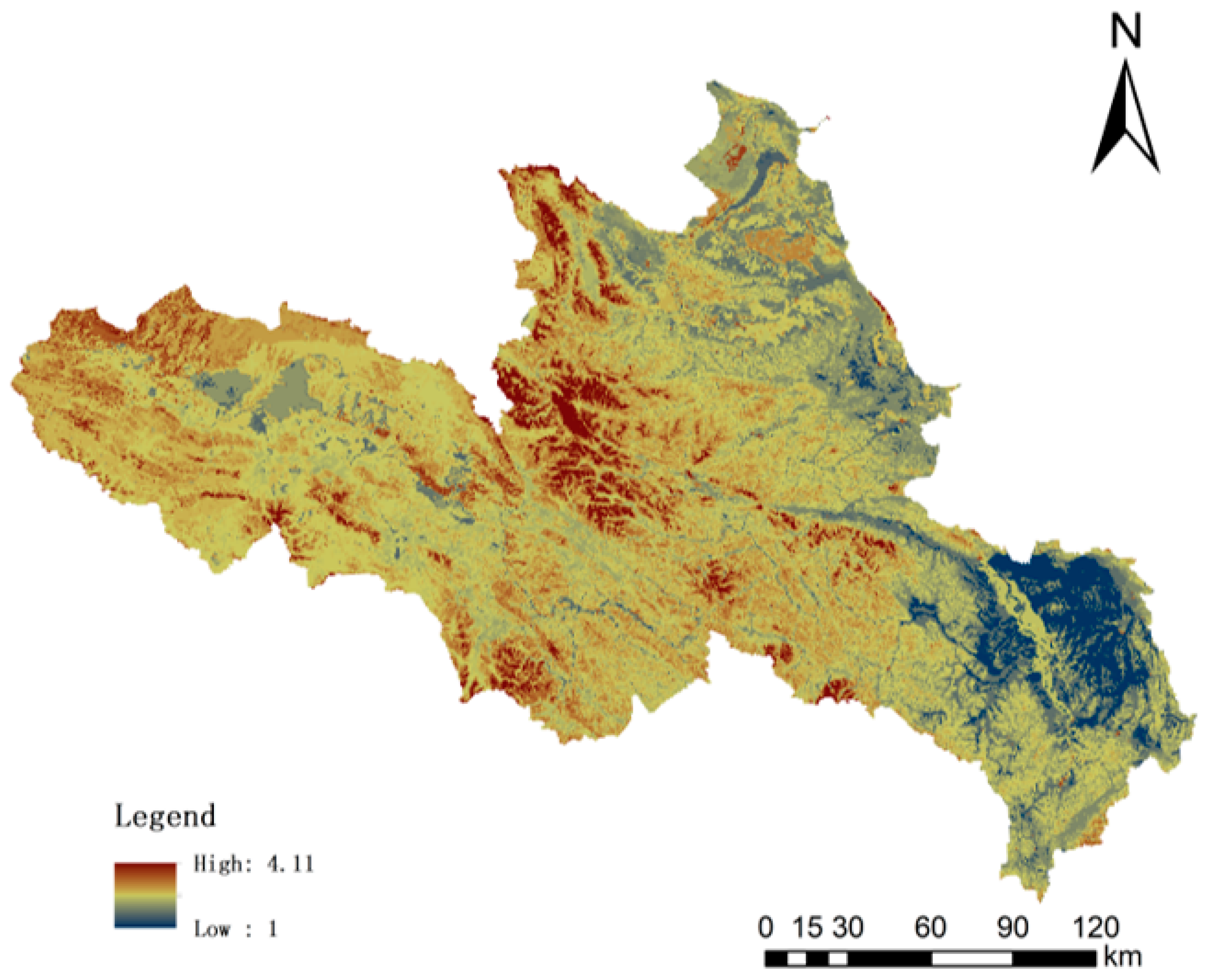
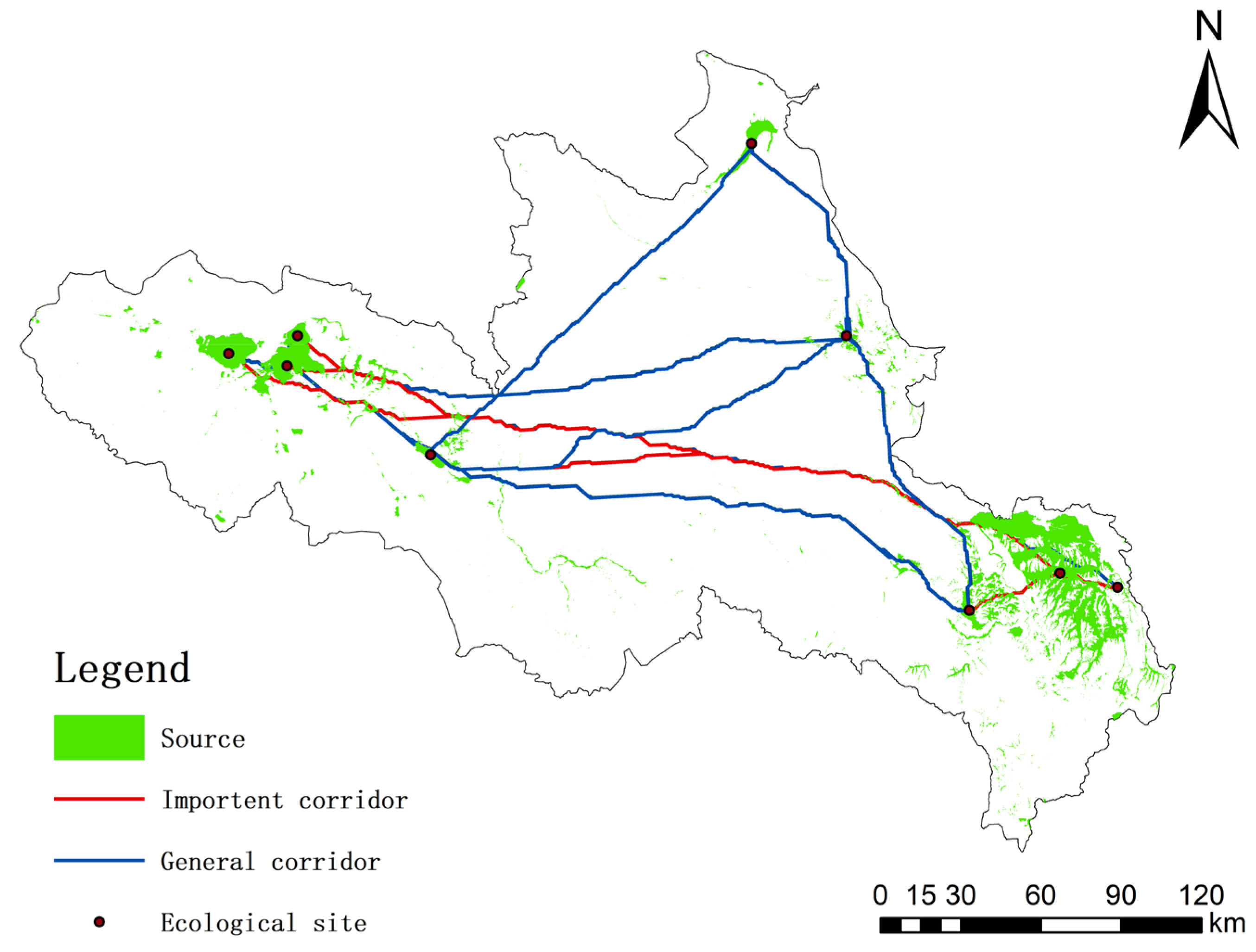
3.2.2. Ecological Corridor
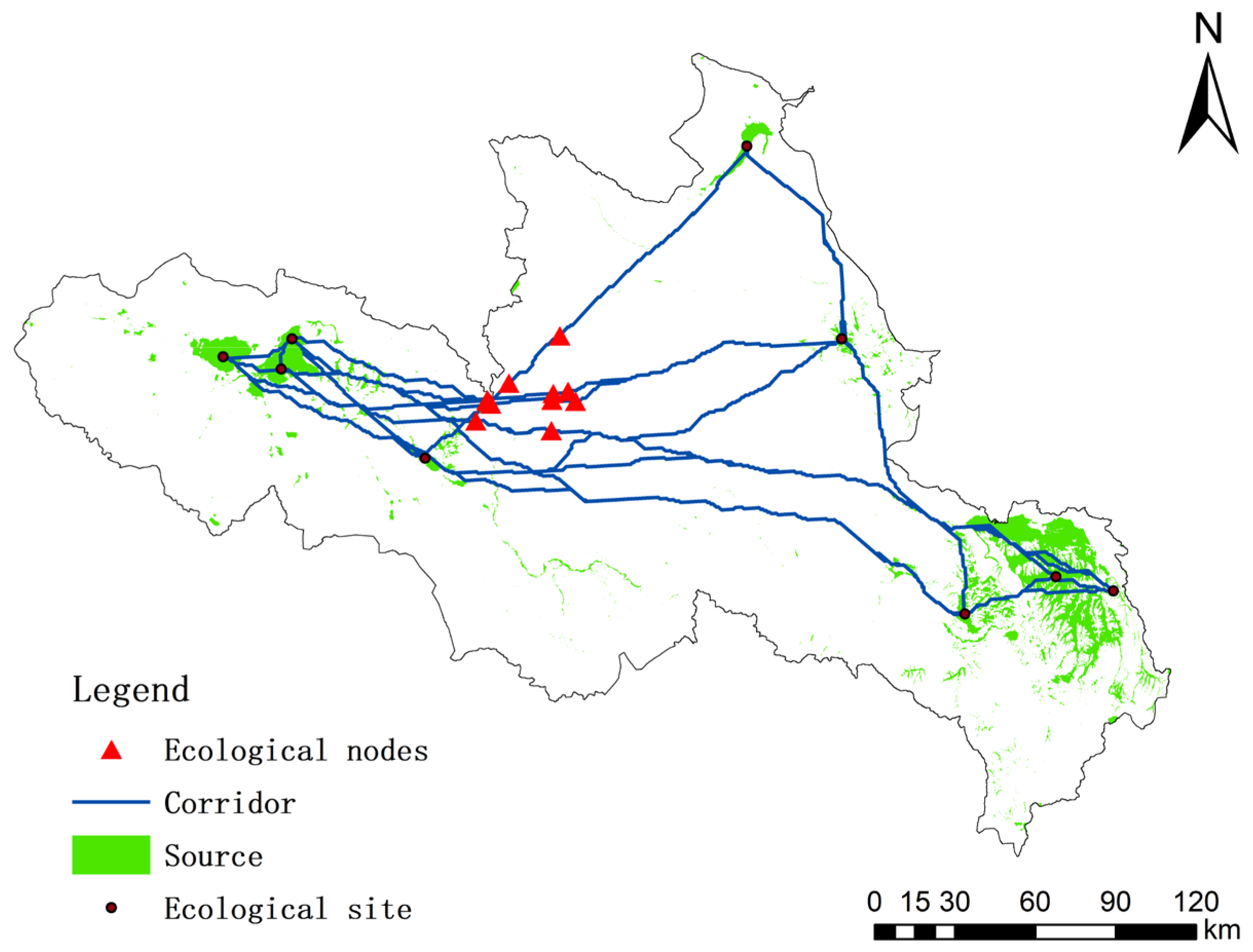
3.2.3. Ecological Nodes
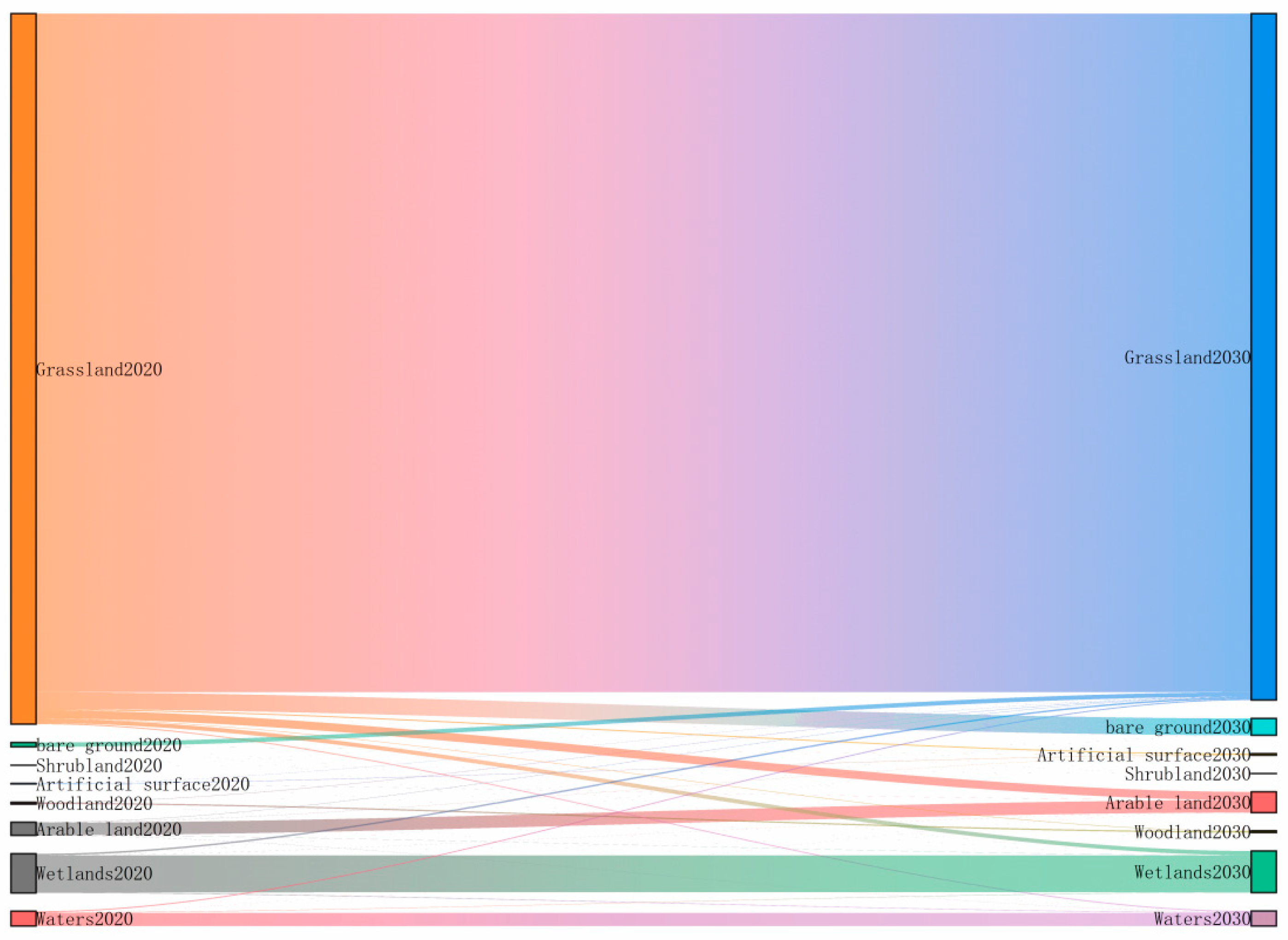
3.3. Simulation Analysis of Land Cover Change
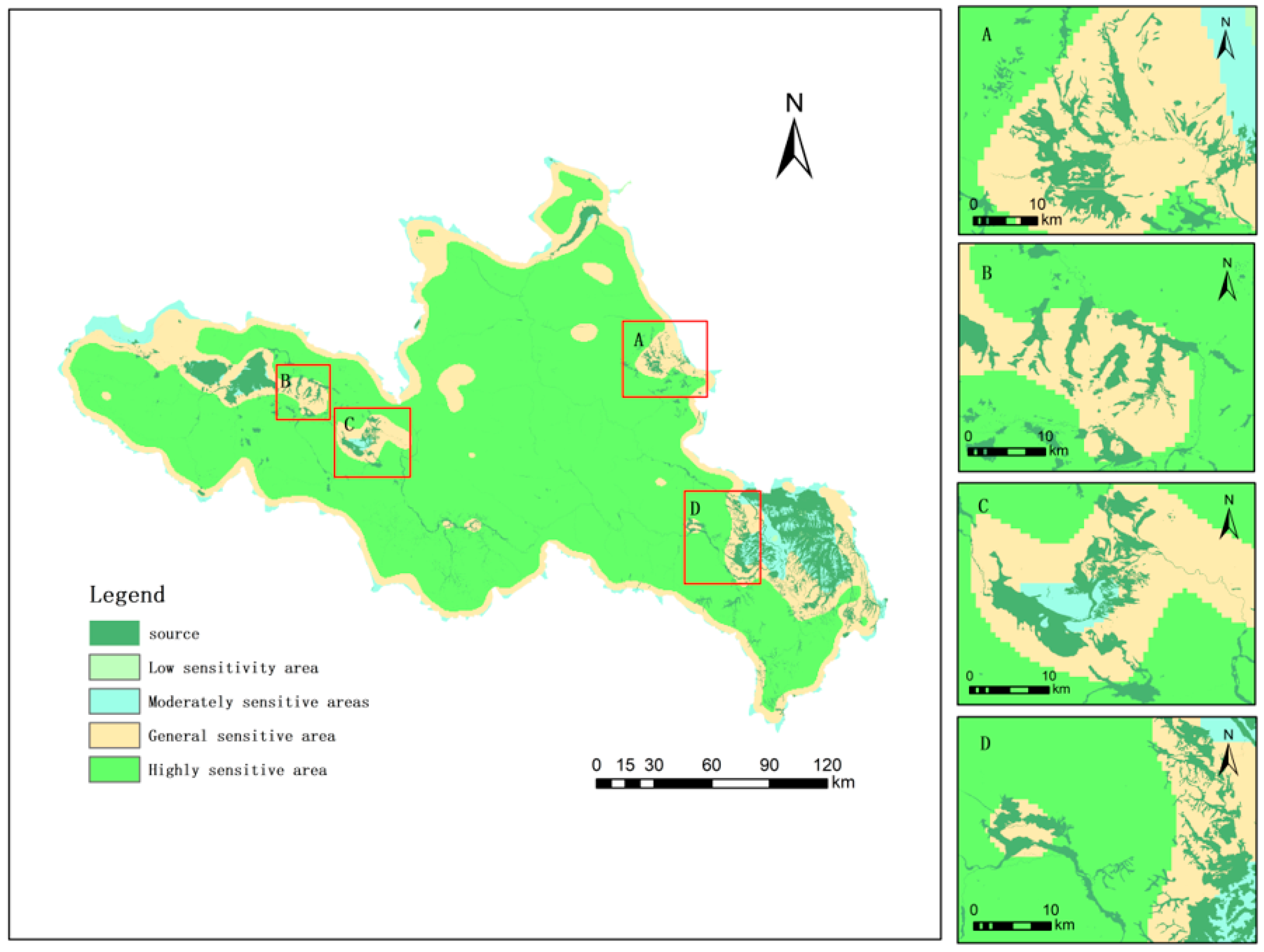
3.4. Early-Warning Points of Ecological Protection Space
4. Discussion
4.1. Restoration Area of Ecological Protection and Identification and Analysis of Early Warning Points
4.2. Strategy of Ecological Restoration and Early Warning in the Important Areas
- Ecological protection belts: the ecological source area mainly includes forest and wetland. In terms of the forest, in order to strengthen the protection and management measures, we should carry out ecological restoration of degraded forests to increase the forest cover. The forest used for commercial purposes is prohibited to prevent the reverse loss of high-quality forest [2]. At the same time, we should protect and promote the natural resilience of forest vegetation. In terms of wetlands, the natural ecosystem of wetlands should be rebuilt or restored through ecological restoration projects. For example, restoring vegetation, improving hydrological conditions of wetlands, protecting and introducing animal species, and strengthening legal protection and policy development.
- Ecological pinch points: Ecological pinch point areas mainly consist of bare land, where the quality of the regional ecological environment can be steadily improved by planting trees and building green parks.
- Ecological early warning points: the ecological early warning area mainly consists of the grass expansion area. The study predicts that the expansion of the grass can squeeze the ecological source areas, which is unfavorable to the ecological pattern of the Yellow River Source Area. An ecological barrier and buffer can be constructed around the ecological source area to ensure the long-term stability of the ecological source areas in the region.
4.3. Insufficiency and Expectations
5. Conclusions
Author Contributions
Funding
Institutional Review Board Statement
Informed Consent Statement
Data Availability Statement
Conflicts of Interest
References
- Fu, F.J.; Liu, Z.H.; Liu, H. Identifying key areas of ecosystem restoration for territorial space based on ecological security pattern: A case study in Hezhou City. Acta Ecol. Sin. 2021, 41, 3406–3414. [Google Scholar]
- Ran, Y.J.; Lei, D.M.; Li, J. Identification of crucial areas of territorial ecological restoration based on ecological security pattern: A case study of the central Yunnan urban agglomeration, China. Ecol. Indic. 2022, 143, 109318. [Google Scholar] [CrossRef]
- Ma, S.F.; Lao, C.H.; Jiang, H.Y. Ecological restoration zoning of territorial space based on the pattern simulation of eco-security scenario: A case study of Guangdong-Hong Kong-Macao Greater Bay Area. Acta Ecol. Sin. 2021, 41, 3441–3448. [Google Scholar]
- Wei, X.D.; Lin, L.G.; Feng, X.L.; Wang, X.F.; Kong, D.H.; Lin, K.L.; Yang, J. Construction of ecological security pattern and quantitative diagnosis of ecological problems in Shenmu City. Acta Ecol. Sin. 2023, 43, 82–94. [Google Scholar]
- Yan, Y.Y.; Sun, Y.W.; Liu, M. Identification and restoration strategy of key areas for territorial space ecological restoration in Shanghai, China based on ecological security pattern. Chin. J. Appl. Ecol. 2022, 33, 3369–3378. [Google Scholar]
- Li, T.; Tang, T.; Deng, H.B.; Wu, G.; Cai, Q.H. Ecological theory and restoration practices of the mountain-river -forest-farmland -lake-grasslands system in the Three Gorges area of Hubei Province. Acta Ecol. Sin. 2019, 39, 8896–8902. [Google Scholar]
- Guan, W.B.; Xie, C.H.; Ma, K.M.; Niu, J.Z.; Zhao, Y.T.; Wang, X.L. A vital method for constructing regional ecological security pattern: Landscape ecological restoration and rehabilitation. Acta Ecol. Sin. 2003, 23, 64–73. [Google Scholar]
- Ni, Q.H.; Hou, H.P.; Ding, Z.Y.; Li, Y.B. Ecological remediation zoning of territory based on the ecological security pattern recognition: Taking Jiawang district of Xuzhou city as an example. J. Nat. Resour. 2020, 35, 204–216. [Google Scholar]
- Yan, L.; Yu, L.; An, M.; Su, H.; Li, H.; Yuan, C. Explanation of the Patterns, Spatial Relationships, and Node Functions of Biodiversity and Island: An Example of Nature Reserves in Guizhou, Southwest China. Sustainability 2019, 11, 6197. [Google Scholar] [CrossRef]
- Cui, L.; Wang, J.; Sun, L.; Lv, C. Construction and optimization of green space ecological networks in urban fringe areas: A case study with the urban fringe area of Tongzhou district in Beijing. J. Clean. Prod. 2020, 276, 124266. [Google Scholar] [CrossRef]
- Chen, C.; Shi, L.; Lu, Y.; Yang, S.; Liu, S. The Optimization of Urban Ecological Network Planning Based on the Minimum Cumulative Resistance Model and Granularity Reverse Method: A Case Study of Haikou, China. IEEE Access 2020, 8, 43592–43605. [Google Scholar] [CrossRef]
- Zhang, X.M.; Du, H.M.; Wang, Y.; Chen, Y.; Ma, L.; Dong, T.X. Watershed landscape ecological risk assessment and landscape pattern optimization: Take Fujiang River Basin as an example. Hum. Ecol. Risk Assess. Int. J. 2021, 27, 2254–2276. [Google Scholar] [CrossRef]
- Wang, B.; Liu, C.Q. Construction and optimization of ecological network based on MSPA and MCR—Taking Jizhou District of Ji’an City as an example. Environ. Prot. Sci. 2021, 47, 37–43. [Google Scholar]
- Wickham, J.D.; Riitters, K.H.; Wade, T.G.; Vogt, P. A national assessment of green infrastructure and change for the conterminous United States using morphological image processing. Landsc. Urban Plan. 2010, 94, 186–195. [Google Scholar] [CrossRef]
- Xu, F.; Yin, H.W.; Kong, F.H.; Xu, J.G. Developing ecological networks based on mspa and the least-cost path method: A case study in bazhong western new distric. Acta Ecol. Sin. 2015, 35, 6425–6434. [Google Scholar]
- Huang, M.Y.; Yue, W.Z.; Fang, B.; Feng, S.R. Scale response characteristics and geographic exploration mechanism of spatial differentiation of ecosystem service values in Dabie Mountain area, central China from 1970 to 2015. Acta Geogr. Sin. 2019, 74, 1904–1920. [Google Scholar]
- Zhang, L.Q.; Peng, J.; Liu, Y.X.; Wu, J.S. Coupling ecosystem services supply and human ecological demand to identify landscape ecological security pattern: A case study in Beijing-Tianjin-Hebei region, China. Urban Ecosyst. 2017, 20, 701–714. [Google Scholar] [CrossRef]
- Peng, J.; Jia, J.L.; Hu, Y.N.; Tian, L.; Li, H.L. Construction of ecological security pattern in the agro-pastoral ecotone based on surface humid index: A case study of Hangjin Banner, Inner Mongolia Autonomous Region, China. Chin. J. Appl. Ecol. 2018, 29, 1990–1998. [Google Scholar]
- Li, Q.; Zhou, Y.; Yi, S. An integrated approach to constructing ecological security patterns and identifying ecological restoration and protection areas: A case study of Jingmen, China. Ecol. Indic. 2022, 137, 108723. [Google Scholar] [CrossRef]
- Li, H.H.; Ma, T.H.; Wang, K.; Tan, M.; Qu, J.F. Construction of Ecological Security Pattern in Norther Peixian Based on MCR and SPCA. J. Ecol. Rural Environ. 2020, 36, 1036–1045. [Google Scholar]
- Chen, X.; Peng, J.; Liu, Y.X.; Yang, Y.; Li, G.C. Constructing ecological security patterns in Yunfu city based on the framework of importance-sensitivity-connectivity. Geogr. Res. 2017, 36, 471–484. [Google Scholar]
- Wang, J.L.; Xie, D.T.; Shao, J.A.; Ni, J.P.; Lei, P. Identification of source-sink risk pattern of agricultural non-point source pollution in cultivated land in Three Gorge Reservoir Area based on accumulative minimum resistance model. Trans. CSAE 2016, 32, 206–215. [Google Scholar]
- Tan, H.Q.; Zhang, J.T.; Zhou, X.S. Construction of ecological security patterns based on minimum cumulative resistance model in Nanjing City. Bull. Soil Water Conserv. 2020, 40, 282–288. [Google Scholar]
- Li, J.; Xu, J.; Chu, J. The Construction of a Regional Ecological Security Pattern Based on Circuit Theory. Sustainability 2019, 11, 6343. [Google Scholar] [CrossRef]
- Peng, J.; Zhao, H.J.; Liu, Y.X. Urban ecological corridors construction: A review. Acta Ecol. Sin. 2017, 37, 23–30. [Google Scholar] [CrossRef]
- Dong, J.; Peng, J.; Liu, Y.; Qiu, S.; Han, Y. Integrating spatial continuous wavelet transform and kernel density estimation to identify ecological corridors in megacities. Landsc. Urban Plan. 2020, 199, 103815. [Google Scholar] [CrossRef]
- Cortina-Segarra, J.; García-Sánchez, I.; Grace, M.; Andrés, P.; Baker, S.; Bullock, C.; Decleer, K.; Dicks, L.V.; Fisher, J.L.; Frouz, J.; et al. Ventocilla Barriers to ecological restoration in Europe: Expert perspectives. Restor. Ecol. 2021, 29, e13346. [Google Scholar] [CrossRef]
- VonThaden, J.; Badillo-Montaño, R.; Lira-Noriega, A.; García-Ramírez, A.; Benítez, G.; Equihua, M.; Looker, N.; Pérez-Maqueo, O. Contributions of green spaces and isolated trees to landscape connectivity in an urban landscape. Urban For. Urban Green. 2021, 64, 127277. [Google Scholar] [CrossRef]
- Lu, Z.B.; Song, Q.; Zhao, J.Y.; Ding, Y.Y. Changes in Ecological Land Patterns and Divergence Trends in Yellow River Source Area from 2005 to 2020. Bull. Soil Water Conserv. 2022, 42, 277–284. [Google Scholar]
- Hou, C.M.; Zhang, Z.Q.; Liu, X.Q.; Li, M. Eco-environmental problem in yellow river source region andcorresponding solutions in sustainable development. China Popul. Resour. Environ. 2001, 11, 51–53. [Google Scholar]
- Hu, J.J.; Hu, G.G.; Dong, Z.B. Particle size characteristics of aeolian desertified land in Madoi Basin of the source region of Yellow River. J. Desert Res. 2022, 42, 242–252. [Google Scholar]
- Hou, J.K.; Cheng, J.J.; Zhang, K.Q.; Zhou, G.Q.; You, H.T.; Han, X.W. Temporal and Spatial Variation Characteristics of Carbon Storage in the Source Region of the Yellow River Based on InVEST and GeoSoS-FLUS Models and Its Response to Different Future Scenarios. Environ. Sci. 2022, 43, 5253–5262. [Google Scholar]
- Mao, Y.F.; Zhou, Q.G.; Wang, T. Spatial–temporal Variation of Carbon Storage and Its Quantitative Attribution in the Three Gorges Reservoir Area Coupled With PLUS—InVEST Geodector model. Resour. Environ. Yangtze Basin 2023, 32, 1042–1057. [Google Scholar]
- Wang, Z.Y.; Huang, C.L.; Li, L.; Lin, Q. Ecological zoning planning and dynamic evaluation coupled with Invest-HFI-Plus model: A case study in Bortala Mongolian Autonomous Prefecture. Acta Ecol. Sin. 2022, 42, 5789–5798. [Google Scholar]
- Yang, Z.G.; Jiang, Z.Y.; Guo, C.X.; Yang, X.J.; Xu, X.J.; Li, X.; Hu, Z.M.; Zhou, H.Y. Construction of ecological network using morphological spatial pattern analysis and minimal cumulative resistance models in Guangzhou City, China. Chin. J. Appl. Ecol. 2018, 29, 3367–3376. [Google Scholar]
- Wang, Y.J.; Qu, Z.Y.; Zhong, Q.H.; Zhang, Q.P.; Zhang, L.; Zhang, R.; Yi, Y.; Zhang, G.L.; Li, X.C.; Liu, J. Delimitation of ecological corridors in a highly urbanizing region based on circuit theory and MSPA. Ecol. Indic. 2022, 124, 1092528. [Google Scholar] [CrossRef]
- Wei, Q.Q.; Abudureheman, H.; Yao, K.X.; Chen, L.M.; Maihemuti, B. Construction and optimization of ecological security pattern in Ebinur Lake Basin based on MSPA-MCR models. Ecol. Indic. 2022, 138, 108857. [Google Scholar] [CrossRef]
- Zhou, S.K.; Song, Y.H.; Li, Y.J.; Wang, J.; Zhang, L. Construction of Ecological Security Pattern for Plateau Lake Based on MSPA–MCR Model: A Case Study of Dianchi Lake Area. Sustainability 2022, 14, 14532. [Google Scholar] [CrossRef]
- Lei, S.; Li, Z.B.; Xiao, L.; Wu, L.F.; Chen, S.Y.; Wei, L.; Yin, Z.Y. Construction and Optimization of Ecological Network of Heyuan City Based on MSPA and MCR Model. For. Environ. Sci. 2023, 39, 1–11. [Google Scholar]
- Lin, J.Y.; Qiu, S.X.; Tan, X.J.; Zhuang, Y.Y. Measuring the relationship between morphological spatial pattern of green space and urban heat island using machine learning methods. Build. Environ. 2023, 228, 109910. [Google Scholar] [CrossRef]
- Wu, C.G.; Zhou, Z.X.; Wang, P.C.; Xiao, W.F.; Teng, M.J. The concept and measurement of landscape connectivity and its applications. Acta Ecol. Sin. 2010, 30, 1903–1910. [Google Scholar]
- Yu, Y.P.; Yin, H.W.; Kong, F.H.; Wang, J.J.; Xu, Y.P. Scale effect of Nanjing urban green infrastructure network pattern and connectivity Analysis. Chin. J. Appl. Ecol. 2016, 27, 2119–2127. [Google Scholar]
- Wang, Y.C. The connectivity evaluation of Shanghai urban landscape eco-network. Geogr. Res. 2009, 28, 284–292. [Google Scholar]
- Zhang, Y.L.; Yi, W.T.; Hu, X.J.; Li, X.H.; Yang, X.J. The Construction of Resource-saving Ecological Network Based on MSPA and MCR Model-A Case Study of Dongshan Island in Fujian Province. J. Northwest For. Univ. 2021, 36, 254–261. [Google Scholar]
- Xu, X.L.; Wang, S.Y.; Rong, W.Z. Construction of ecological network in Suzhou based on the PLUS and MSPA models. Ecol. Indic. 2023, 154, 110740. [Google Scholar] [CrossRef]
- Liu, C.F.; Zhou, B.; He, X.Y.; Chen, W. Selection of distance thresholds of urban forest landscape connectivity in Shenyang City. Chin. J. Appl. Ecol. 2010, 21, 2508–2516. [Google Scholar]
- Chen, Y.H.; Lei, Y.Q.; Xing, Y.L.; Zhao, M. Research on Ecological Security Pattern Construction in Fuliang County based on MSPA-MCR Mode. J. Shandong For. Sci. Technol. 2022, 52, 12–18+26. [Google Scholar]
- Liu, J.L.; Li, S.P.; Fan, S.L.; Hu, Y. Identification of territorial ecological protection and restoration areas and early warning places based on ecological security pattern: A case study in Xiamen-Zhangzhou-Quanzhou Region. Acta Ecol. Sin. 2021, 41, 8124–8134. [Google Scholar]
- Hu, C.; Wang, Z.; Wang, Y.; Sun, D.; Zhang, J. Combining MSPA-MCR Model to Evaluate the Ecological Network in Wuhan, China. Land 2022, 11, 213. [Google Scholar] [CrossRef]
- Song, S.; Wang, S.H.; Shi, M.X.; Hu, S.S.; Xu, D.W. Multiple scenario simulation and optimization of an urban green infrastructure network based on complex network theory: A case study in Harbin City, China. Ecol. Processes 2022, 11, 33. [Google Scholar] [CrossRef]
- Li, Y.Y.; Zhang, Y.Z.; Jiang, Z.Y.; Guo, C.X.; Yang, Z.G.; Guo, M.Y.; Wu, B.Y.; Chen, Q.L. Integrating morphological spatial pattern analysis and the minimal cumulative resistance model to optimize urban ecological networks: A case study in Shenzhen City, China. Ecol. Processes 2021, 10, 63. [Google Scholar] [CrossRef]
- Shao, R.Y.; Luo, Z.W.; Hu, X.J.; Wang, Y.Z.; Zhang, J.Y. The Construction of Zhuzhou Ecological Network Based on MSPA and MCR Mode. J. Northwest For. Univ. 2023, 4, 26. [Google Scholar]
- Tian, S.J.; Zhang, W.J.; He, L.; Miao, J.Y.; Zi, Y.K. Construction and Optimization of Chengdu Ecological Network Based on Linkage Mapper and Complex Network. J. Northwest For. Univ. 2023, 38, 176–184. [Google Scholar]
- Jiang, S.X.; Li, X.; Wang, G.Q.; Chen, Y.; Weng, S.X. Regional ecological security pattern of Fujian and Guangdong networking project (Fujian section) based on the minimum cumulative resistance model. Bull. Surv. Mapp. 2023, 04, 16–22. [Google Scholar]
- Zheng, Q.M.; Hu, J.H.; Sheng, M.Z. Construction of Ecological Network in Hunan Province Based onMSPA and MCR Models. J. Nat. Sci. Hunan Norm. Univ. 2021, 44, 1–10. [Google Scholar]
- Ye, H.; Yang, Z.; Xu, X. Ecological Corridors Analysis Based on MSPA and MCR Model—A Case Study of the Tomur World Natural Heritage Region. Sustainability 2020, 12, 959. [Google Scholar] [CrossRef]
- Zhao, Y.S.; Ning, B.; Wang, R. Research on Ecological Network Problem Identification of Shenmu Based on InVEST and MCR model. Territ. Nat. Resour. Study 2023, 3, 55–60. [Google Scholar]
- Gong, S.X.; Zhang, Y.H.; Li, Y.H. Spatio–temporal variation and prediction of carbon storage in Beijing–Tianjin–Hebei region—A PLUS—InVEST model approach. J. Arid. Land Resour. Environ. 2023, 37, 20–28. [Google Scholar]
- Li, S.P.; Liu, J.L.; Lin, J.; Fan, S.L. Spatial and Temporal Evolution Simulation of Eco economic SystemCoordination in Fujian Province Under Land Use Scenarios. J. Soil Water Conserv. 2021, 28, 234–241. [Google Scholar]
- Shen, R.; Shi, Z.T.; He, G.X.; Xu, R. Construction and Optimization of the Ecological Security Pattern of Xishuangbanna Based on Fragmentation Index. Trop. Geogr. 2022, 42, 1363–1375. [Google Scholar]
- Wei, B.J.; Su, J.; Hu, X.J.; Xu, K.H.; Zhu, M.L.; Liu, L. Comprehensive identification of eco-corridors and eco-nodes based on principle of hydrological analysis and Linkage Mapper. Acta Ecol. Sin. 2022, 42, 2995–3009. [Google Scholar]
- Cao, X.; Liu, Z.; Li, S.; Gao, Z. Integrating the Ecological Security Pattern and the PLUS Model to Assess the Effects of Regional Ecological Restoration: A Case Study of Hefei City, Anhui Province. Int. J. Environ. Res. Public Health 2022, 19, 6640. [Google Scholar] [CrossRef]
- Wang, Z.F.; Liu, Y.; Xie, X.Q.; Wang, X.Q.; Lin, H.; Xie, H.L. Identifying Key Areas of Green Space for Ecological Restoration Based on Ecological Security Patterns in Fujian Province, China. Land 2022, 11, 1496. [Google Scholar] [CrossRef]

| Data Type | Data Name | Resolution/m | Data Sources |
|---|---|---|---|
| Environmental factors | DEM | 30 | (https://www.gscloud.cn, accessed on 6 May 2023) |
| Slope | 30 | ||
| Aspect | 30 | ||
| Average annual temperature | 1000 | (https://www.resdc.cn, accessed on 6 May 2023) | |
| Average annual precipitation | 1000 | ||
| soil types | 1000 | ||
| Socioeconomic factors | Population density | 1000 | |
| GDP | 1000 | ||
| Distance from road | 1000 | (https://www.webmap.cn, accessed on 6 May 2023) |
| Types | Significance |
|---|---|
| Core | The large ecological patch in the foreground has great significance for the protection of biodiversity and can be used as an ecological source |
| Bridge | Represents corridors connecting patches in ecological networks, plays an important role in landscape connectivity and species migration |
| Edge | Area between the core area and the non-green landscape |
| Loop | The channel connecting the same core area is a shortcut to species migration within the same core area |
| Perforation | Transition region between the core area and the non-green patches, with a marginal effect |
| Branch | The area with only one end connected to the main patch is a gateway for species migration with the surrounding landscape |
| Islet | Unconnected small and broken plates have a low connectivity between plates and a low possibility to communicate between matter and energy |
| Rank | Patch Number | dPC |
|---|---|---|
| 1 | 28 | 88.20 |
| 2 | 11 | 5.65 |
| 3 | 21 | 2.68 |
| 4 | 7 | 2.41 |
| 5 | 4 | 2.09 |
| 6 | 24 | 1.05 |
| 7 | 1 | 0.81 |
| 8 | 14 | 0.13 |
| 9 | 5 | 0.07 |
| Resistance Factor | Classification Index | Resistance Value | Resistance Factor | Classification Index | Resistance Value |
|---|---|---|---|---|---|
| Land cover class Land cover types | Woodland | 1 | NDVI | 0–0.15 | 1 |
| Waters, wetlands, | 2 | 0.15–0.30 | 2 | ||
| grassland | 3 | 0.30–0.45 | 3 | ||
| Arable, bare land | 4 | 0.45–0.60 | 4 | ||
| Construction land | 5 | 0.60–1.00 | 5 | ||
| Elevation (m) | 2442–3538 | 1 | slope | <5 | 1 |
| 3538–4009 | 2 | 5–14 | 2 | ||
| 4009–4425 | 3 | 14–35 | 3 | ||
| 4425–6253 | 4 | >35 | 4 | ||
| Undulation | 0–40 | 1 | |||
| 40–74 | 2 | ||||
| 74–123 | 3 | ||||
| 123–509 | 4 |
| Resistance Factor | Slope | Terrain Relief | Elevation | NDVI | Land Cover Types |
|---|---|---|---|---|---|
| Weight | 0.14 | 0.11 | 0.12 | 0.11 | 0.52 |
| Sources | 1 | 2 | 3 | 4 | 5 | 6 | 7 | 8 | 9 |
|---|---|---|---|---|---|---|---|---|---|
| 1 | 0 | 9.372375 | 5123.577 | 8.159389 | 7.773109 | 963.6156 | 39.97243 | 26.94694 | 86.43863 |
| 2 | 0 | 0 | 5.958088 | 607.4128 | 1313.409 | 3.93233 | 10.77165 | 132.9208 | 8.134737 |
| 3 | 0 | 0 | 0 | 5.13926 | 4.728536 | 277.4067 | 23.00005 | 15.8188 | 45.42402 |
| 4 | 0 | 0 | 0 | 0 | 346.0057 | 3.387442 | 8.967676 | 75.08603 | 6.756133 |
| 5 | 0 | 0 | 0 | 0 | 0 | 3.122579 | 8.677166 | 94.73598 | 6.594327 |
| 6 | 0 | 0 | 0 | 0 | 0 | 0 | 16.24322 | 52.64829 | 8.304472 |
| 7 | 0 | 0 | 0 | 0 | 0 | 0 | 0 | 163.8385 | 21.26972 |
| 8 | 0 | 0 | 0 | 0 | 0 | 0 | 0 | 0 | 24.70312 |
| 9 | 0 | 0 | 0 | 0 | 0 | 0 | 0 | 0 | 0 |
| 2020 | 2030 | |||||||
|---|---|---|---|---|---|---|---|---|
| Arable Land | Woodland | Grassland | Shrubland | Wetlands | Waters | Artificial Surface | Bare Ground | |
| Arable land | 1990 | 0 | 49 | 0 | 23 | 19 | 23 | 1 |
| Woodland | 0 | 216 | 56 | 0 | 0 | 3 | 0 | 0 |
| Grassland | 1317 | 77 | 108,709 | 2 | 663 | 180 | 184 | 2698 |
| Shrubland | 0 | 0 | 2 | 2 | 0 | 0 | 0 | 0 |
| Wetlands | 10 | 1 | 257 | 0 | 5913 | 92 | 3 | 3 |
| Waters | 5 | 2 | 176 | 0 | 67 | 2129 | 2 | 1 |
| Artificial surface | 12 | 0 | 21 | 0 | 2 | 1 | 65 | 0 |
| bare ground | 0 | 0 | 706 | 0 | 3 | 4 | 5 | 4720 |
Disclaimer/Publisher’s Note: The statements, opinions and data contained in all publications are solely those of the individual author(s) and contributor(s) and not of MDPI and/or the editor(s). MDPI and/or the editor(s) disclaim responsibility for any injury to people or property resulting from any ideas, methods, instructions or products referred to in the content. |
© 2023 by the authors. Licensee MDPI, Basel, Switzerland. This article is an open access article distributed under the terms and conditions of the Creative Commons Attribution (CC BY) license (https://creativecommons.org/licenses/by/4.0/).
Share and Cite
Wang, S.; Song, Q.; Zhao, J.; Lu, Z.; Zhang, H. Identification of Key Areas and Early-Warning Points for Ecological Protection and Restoration in the Yellow River Source Area Based on Ecological Security Pattern. Land 2023, 12, 1643. https://doi.org/10.3390/land12081643
Wang S, Song Q, Zhao J, Lu Z, Zhang H. Identification of Key Areas and Early-Warning Points for Ecological Protection and Restoration in the Yellow River Source Area Based on Ecological Security Pattern. Land. 2023; 12(8):1643. https://doi.org/10.3390/land12081643
Chicago/Turabian StyleWang, Shiru, Qian Song, Jianyun Zhao, Zhibo Lu, and Haoxiang Zhang. 2023. "Identification of Key Areas and Early-Warning Points for Ecological Protection and Restoration in the Yellow River Source Area Based on Ecological Security Pattern" Land 12, no. 8: 1643. https://doi.org/10.3390/land12081643
APA StyleWang, S., Song, Q., Zhao, J., Lu, Z., & Zhang, H. (2023). Identification of Key Areas and Early-Warning Points for Ecological Protection and Restoration in the Yellow River Source Area Based on Ecological Security Pattern. Land, 12(8), 1643. https://doi.org/10.3390/land12081643