Article

How to Rebalance the Land-Use Structure after Large Infrastructure Construction? From the Perspective of Government Attention Evolution

1
School of Tourism, The Center of Targeted Poverty Alleviation and Rural Revitalization, Xinyang Normal University, Xinyang 464000, China
2
School of Geographic Sciences, The Center of Targeted Poverty Alleviation and Rural Revitalization, Xinyang Normal University, Xinyang 464000, China
*
Authors to whom correspondence should be addressed.
Land 2023, 12(8), 1632; https://doi.org/10.3390/land12081632
Submission received: 1 August 2023 / Revised: 15 August 2023 / Accepted: 16 August 2023 / Published: 20 August 2023
(This article belongs to the Special Issue Agricultural Land Use and Rural Development)

Abstract

:
Large infrastructure projects play a crucial role in regional development but can also negatively impact cultivated-land protection. This study focuses on the role of local governments in land-use conflicts and the rebalancing of land-use structures during large infrastructure construction. Using the construction of a reservoir in the Huaihe River as a case study, the research examines the evolution of government attention and the process of township local governments promoting land-use adjustment. The findings reveal that local governments go through a process of “Create–Reinforce–Adjust–Delivery” in their attention to reservoir construction to maximize their interests. Attention fluctuates in terms of reservoir construction, cultivated-land protection, and immigration-development assistance. Biased land-use decisions were made at different stages, leading to four stages of rebalancing efforts: “Generation–Challenge–Marked effect–Continuous negative impact”. This process provides insights into land-use decision-making and the rebalancing of land-use structure. The study suggests that the superior government should guide local governments to enhance attention to cultivated-land protection through laws and policies, while local governments should focus on the quality protection of cultivated land and mitigate the negative impact of rebalancing efforts.

1. Introduction

Cultivated land and its agricultural production functions play a crucial role in ensuring food security and are essential for achieving the United Nations 2030 goal of “eradicating poverty and hunger” [1]. Currently, approximately 10% of the global population lives in extreme poverty, with around 820 million people suffering from hunger. It is, therefore, imperative to protect cultivated land, as it serves as a vital guarantee for addressing these challenges. Simultaneously, the “Global Infrastructure Outlook” report highlights a projected investment gap of USD 15 trillion in global infrastructure by 2040, particularly in developing countries [2]. The demand for infrastructure construction poses significant pressure and challenges for safeguarding cultivated land, particularly in developing nations. China, as the world’s most populous developing country, has impressively achieved its goal of eliminating absolute poverty ten years ahead of schedule; nonetheless, the protection of cultivated land remains a strategic priority due to its large population of 1.4 billion [3]. Both cultivated-land conservation and large infrastructure construction are critical and pressing issues. However, the construction of large infrastructure inevitably results in the occupation of various types of land, particularly arable land. Failure to address the reduction and imbalance of cultivated land caused by large infrastructure projects could pose hidden risks to regional food production and overall food security.
With the rapid development of the global economy and society, the situation of large infrastructure occupying cultivated land is increasingly serious. Various types of large infrastructure construction, such as Roads [2], Airports [4], Water conservancy facilities [5], and Ports [6], directly occupy cultivated land, which not only changes the regional land-use pattern but also affects the regional landscape pattern [7]. The resulting increase in service demand has promoted the development of regional cities and towns, increased competition risks in land use [8], and even led to consequences such as the degradation of habitat quality [9], the reduction of ecosystem service value [10,11], and the forced transformation of local residents’ livelihoods [12]. Therefore, many scholars try to find solutions by explaining the influencing factors and formation mechanism of land-use function conflict, quantity imbalance, and space occupation using stakeholder theory and game theory [13,14]. It is generally believed that the scarcity of land resources and the different demands of stakeholders are the underlying causes of many land-use problems [15,16]. These problems evolve in the mutual game of multiple subjects [17], with the interest subjects including land managers, land investors, and land users. Their game relations involve the game between the three parties and the internal game of land managers.
The main influence in rural areas, where the game among the three parties is usually represented by “local government–enterprises (developers)–farmers”, is reflected in the improper operation of land acquisition, replacement, compensation, and other aspects [18,19]. This leads to government and people compensation disputes, which have a negative impact on the livelihood of local residents and the surrounding environment [20]. To effectively prevent conflicts and benefit rural communities and the surrounding environment [21], the government and enterprises should fully consider the demands of farmers and formulate transparent, open, and clear processes and policies according to the site selection, planning, construction, and management of large infrastructure.
The internal game of land managers is mainly the interaction between different levels of government. Having different dominant holders of land planning leads to different game processes. In countries or regions where land-use planning is dominated by the local government, land planning is primarily carried out at the county or city level or in urban areas [22]. Large infrastructure construction is entrusted by the federal government to the state government, and the degree of achieving the goals is assessed. The local government is then responsible for specific construction and maintenance with the support of the state government [23]. However, if the local government is unwilling to restrict the use of land or cultivated land for the construction of large infrastructure, their land-use decisions may damage the construction and operation of important national large infrastructure [24]. The study suggests that the federal government, state governments, and local governments must “share the challenges” and make responsible land-use decisions through cooperative efforts to protect cultivated land for global food security [25]. In countries or regions where the state dominates land planning, the land-use planning power of local governments comes from the authorization of the central government, which is a series of top-down and prospective planning systems [26]. This makes the construction and operation of key national infrastructure unaffected by local land-use decisions. However, this does not mean that local governments lack institutional space to exercise their power [27]. The central government often implements the requirements of land use and land protection from the perspective of national protection of public interests; Local governments pursue the property value of land and rely on land financing to promote regional development [28]. The central and local governments have different views on the value of large infrastructure construction and cultivated-land protection from different perspectives, which makes the local governments not only need to protect the public interests but also need to consider the financial benefits brought by the land, thus leading to the local governments to carry out the rebalancing efforts of land use. The research recommends that the central government should build a cultivated-land protection system with economic incentives as the core, introduce economic means into cultivated-land protection, and improve the management system of construction land indicators [29]. It is also noted that if the local government can implement effective cultivated-land protection decisions, the reduction of cultivated-land area will be curbed to a certain extent [30].
The existing research rarely treats large infrastructure construction and cultivated-land changes from the perspective of land-use decision-making of local governments and fails to clarify the rebalancing-efforts process carried out by local governments to consider large infrastructure construction and cultivated-land protection. However, in RLCCP, the role of local governments as actual executors, participants, and stakeholders is irreplaceable. Local governments cannot make the most perfect decision, but can only comprehensively evaluate and weigh multiple factors to make “relatively reasonable and relatively satisfactory” decisions, thus forming a shift in the focus of government attention [31,32]. As decision-makers, local governments have limited attention to a specific issue under the influence of multiple factors such as organizational systems, social factors, sudden public events, and personal cognition. Therefore, the process of decision-makers actively choosing the focus of attention will lead to a shift in the limited attention of the government, resulting in a shift in the direction of government decision-making [33]. However, scholars analyze government decision-making behavior from a completely objective and rational perspective or analyze government decision-making results from the perspective of fully considering farmers’ interests and demands, it is an ideal situation, and the conclusions drawn may not be in line with reality. Local governments face multiple driving forces from different entities, such as farmers, enterprises, and governments at all levels, requiring continuous weighing of decision-making directions. Among them, farmers’ interest demands for land resource utilization, personal economic development, and personal living conditions, etc., are only one aspect of government decision-making considerations. Therefore, the perspective of government attention can better explain the process of local governments making “relatively reasonable and relatively satisfactory” decisions based on limited attention driven by multiple factors.
This study focuses on RLCCP, which examines the land-use structure changes caused by the construction of large reservoirs. The main objective is to explore the government’s attention from three perspectives. First, it examines the changes that have occurred in the land-use structure during large reservoir construction. Second, it analyzes the changes in local government’s attention at different stages of the construction and the resulting adjustments in land use. Lastly, it identifies the driving factors that influence the local government’s efforts in land use rebalancing based on the changing level of government attention. By addressing these questions, the study aims to provide theoretical support for promoting the coordinated development of large infrastructure construction and cultivated-land protection.

2. Materials and Methods

2.1. Overview of the Study Area

The Huaihe River basin, located in the transition climate from a subtropical to a warm temperate zone, is one of the seven major basins in China. It serves as a crucial grain production area, accounting for about 11.7% of the total cultivated area and approximately 17.4% of the total grain output of the country [34]. The study area, situated in a township in the upper reaches of the Huaihe River basin, consists mostly of agricultural land, with rice being the primary food crop. In light of the frequent drought and flood disasters in this region, the central government approved the construction of a large reservoir project in 2011. This significant project, which completed its acceptance process in 2021, is the only flood control system on the upper reaches of the Huaihe River trunk line. It holds great importance in the mitigation of flood-related issues and disaster reduction. The study area encompasses a total area of 13,944.37 hectares, with the submerged area of the large reservoir comprising 14.39% of the total area. Furthermore, it is worth noting that the registered resident population of the township was 55,892 as of 2019. Within the township, there are 75 industrial enterprises, one of which is classified as above designated size. The total output value of the township reaches 903 million yuan, and the per capita net income of farmers amounts to 17,807 yuan.

2.2. Research Method

2.2.1. Spatial Analysis

This study utilized the ArcGIS spatial analysis technology platform (Esri; Berkeley, CA, USA; Version 10.7) to examine the spatial distribution characteristics of land-use data. Spatial analysis methods, including kernel density analysis and buffer zone analysis, were employed for this purpose. Kernel density analysis was utilized to determine the density of point elements or line elements in the neighborhood. On the other hand, buffer analysis involves creating a polygon layer surrounding geographical elements to assess the relationship between them by overlaying with the target layer. In this study, nuclear density analysis was used to measure the degree of concentration of village construction land and road network density. Moreover, buffer zone analysis was applied to assess the relationship between village construction land and cultivated-land abandonment at various distances.

2.2.2. Natural Language Processing

This paper utilizes NVIVO 11 (QSR International; Burlington, MA, USA; Version 1.6.1) for natural language analysis (NLP). Natural language is classified and quantified through semantic coding. The semantic code of “Reservoir Construction” (RC) comprises the staged decision-making in the process of reservoir construction and resettlement. The semantic code of “Immigration-development Assistance” (IA) encompasses support measures such as community management, employment assistance, and fund distribution. Lastly, the semantic code of “Cultivated-land Protection” (CP) involves measures like cultivated-land protection publicity, food planting, pollution control, and supervision measures.

2.3. Data Source and Processing

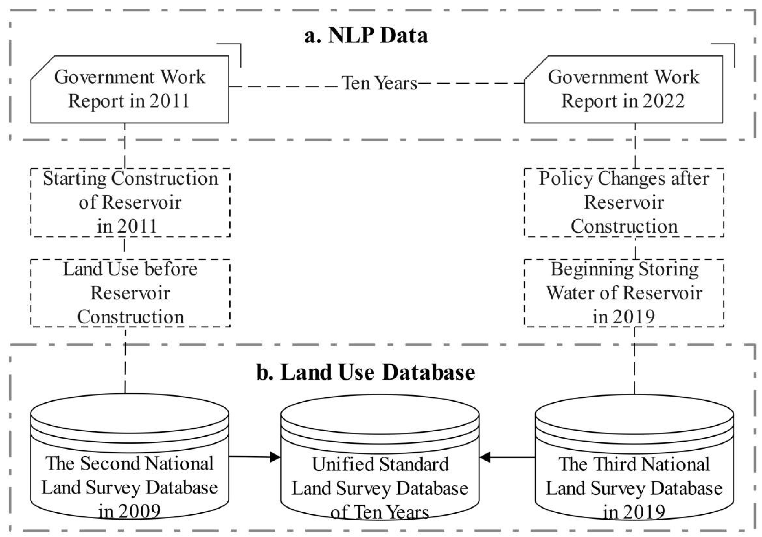
2.3.1. Land-Use Data Sources and Processing

The land-use data in the study area is derived from the second and third national land survey databases. However, since there are differences in statistical caliber, principles, and methods between the two surveys, it is necessary to revise the land types and names based on the actual survey in the study area and the Second National Land Survey Technical Specification (TD/T 1014-2007). In this revision, agricultural land includes 11 land types, construction land includes 8 land types, and unused land includes 4 land types, resulting in a total of 23 land types (Table 1). Specifically, the cultivated land mentioned in this paper encompasses Paddy Field, Irrigated Land, and Dry Land. Additionally, the land for reservoir construction consists of Reservoir Surface and Hydraulic Construction Land.

2.3.2. Natural Language Processing Data Source and Processing

The publication of government work reports is the right and obligation of governments at all levels under the Constitution of China. The government work report is more instructive and authoritative as compared to general administrative decision-making and is considered the highest decision-making document on an annual basis [35]. The data for natural language processing (NLP) in this study is from the 2011–2022 government work report of the study area. By searching keywords, this paper carries out semantic coding to reveal the law of local government’s policy change among different issues through “local government’s attention change”. Additionally, a quantitative comparison is conducted by constructing an indicator of “local government attention intensity” which refers to the degree of local government’s attention to an issue, expressed by the proportion of the text of the government work report.
The land-use situation before reservoir construction in the research area was represented by the Second National Land Survey data in 2009. Due to the start of reservoir construction in 2011, 2011 was chosen as the starting stage for local government attention changes. The data from The Third National Land Survey in 2019 represented the land-use situation after the reservoir storage, as the reservoir construction officially began to store water in 2019. To further explore the trend of land-use policy changes after the completion of reservoir construction, 2022 is chosen as the deadline for local government attention to change analysis (Figure 1).

3. Results

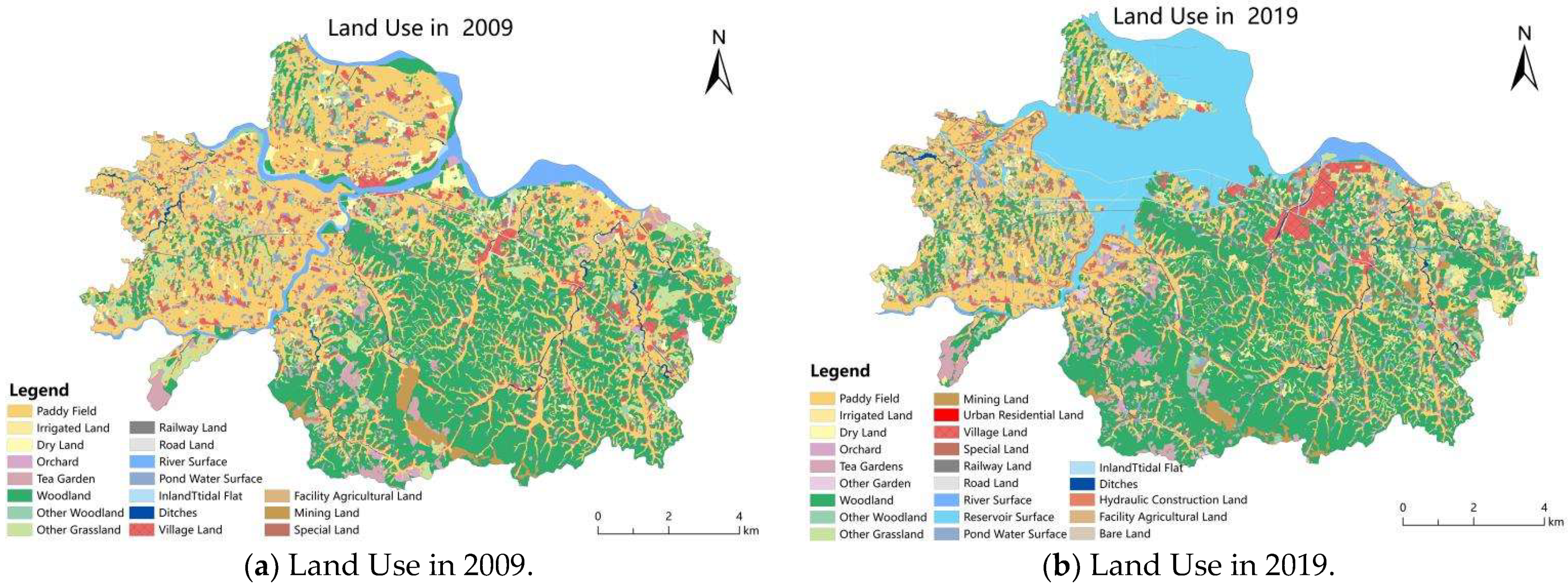
3.1. Comparison of Land-Use Status from 2009 to 2019

From 2009 to 2019, the main trend of land-use change in the study area was a decrease in agricultural land and an increase in construction land, as well as the efficient utilization of previously unused land (Figure 2). The total area of agricultural land, which was the primary land-use type, decreased by 9.11% during this period, leading to a change in the dominant land-use type. In 2009, paddy fields accounted for 36.21% and forest land accounted for 32.27% of the land use. The remaining land-use types were all less than 10%. By 2019, forest land had become the predominant land-use type, accounting for 34.45%. The significant decrease in paddy field area was the main reason for the reduction in agricultural land and the change in the primary land-use type in the study area. Over the past ten years, the area of paddy fields decreased to 22.20%. As paddy fields were the primary cultivated land in the study area, the decrease in paddy field area directly led to a decrease in the overall cultivated land area. Compared to 2009, the scale of cultivated land decreased by 40.19% over the ten years. In 2019, the scale of construction land in the study area was 2.67 times larger than it was ten years ago, mainly due to changes in reservoirs, transportation infrastructure, and village construction land. The construction of reservoirs contributed the most to the growth of construction land, accounting for 98.17% of the increase. Additionally, the proportion of road network area increased by 59.89% compared to 2009, resulting in a significant improvement in traffic accessibility, reflected by the maximum linear density increasing from 0.74 to 1.91. The maximum nuclear density of village construction land also increased from 0.27 to 0.48, indicating a significant increase in concentration. Moreover, the rate of unused land decreased from 9.07% to 2.18% as previously unused land was developed and utilized. Among these changes, grassland and river water surfaces had the highest rates of reuse, accounting for 60.68% and 36.98% of the decrease in unused land, respectively.
According to the comparative analysis of land-use change from 2009 to 2019, the primary type of cultivated-land use, paddy field, directly led to a sharp decline in the scale of cultivated land in the study area. Additionally, the construction land increased significantly due to the reservoir construction. The effective utilization of other grasslands and rivers was also observed. To determine the direct relationship between the change and result of this land-use adjustment and the land-use decision of the local government in the study area, it is necessary to combine the reservoir construction process, analyze the characteristics of land-use transfer in the study area, and further explain the process of regional land-use structure adjustment.

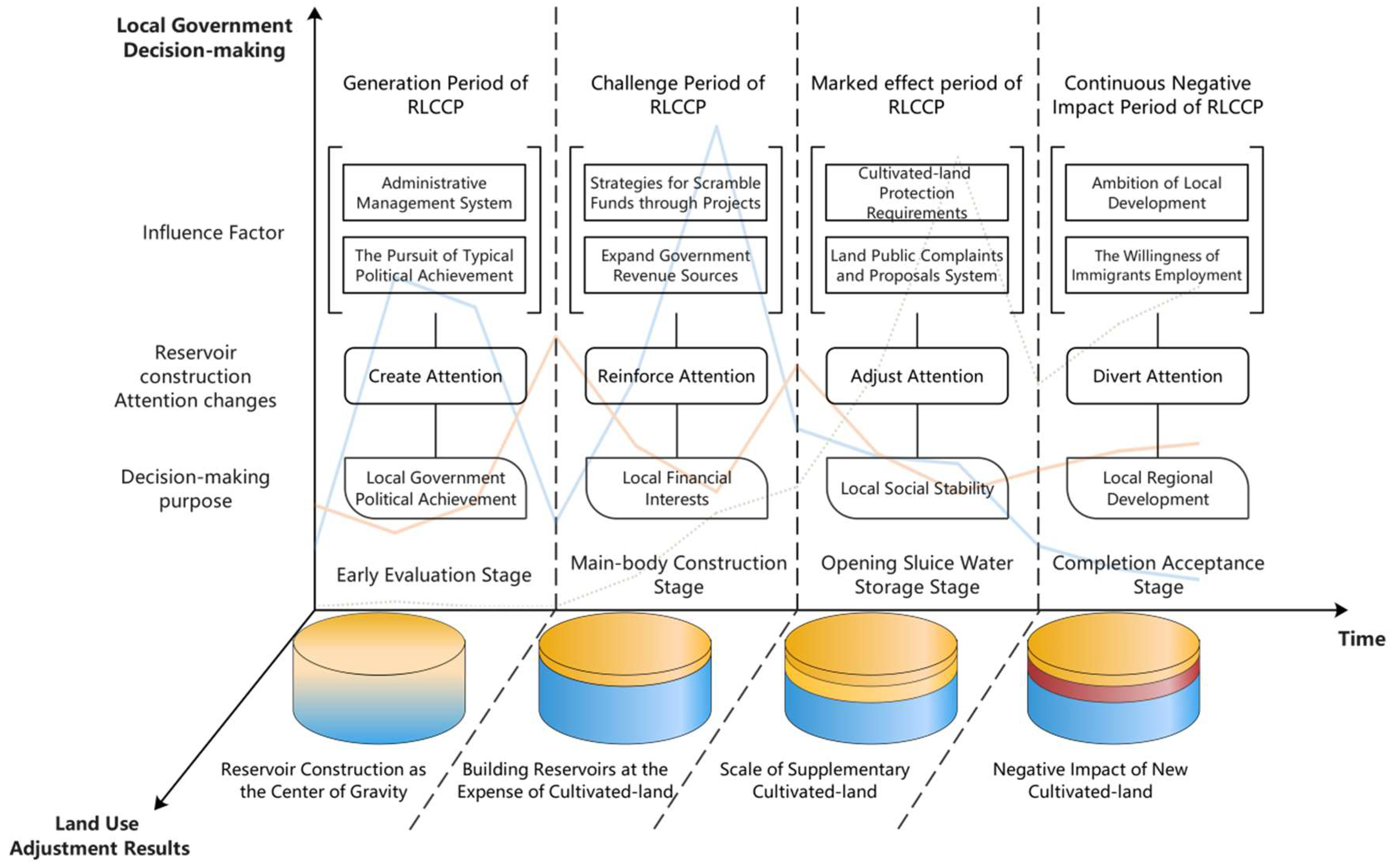
3.2. Results of Land-Use Adjustment from the Perspective of Government Attention

As a leader and stakeholder in reservoir construction and cultivated-land protection, the local government’s attention distribution and transfer process (Figure 3) directly influences land-use decision-making and is manifested in the form of land-use adjustment (Figure 4). Land-use change, which serves as a reflection of the government’s land-use decisions, reflects society [36].

3.2.1. Create Attention: Reservoir Construction as the Center of Gravity

From 2011 to 2014, during the Early Evaluation Stage of large reservoir construction, the local government in the study area exhibited a shift in focus toward reservoir construction. Initially, while the central government decided to build the large reservoir, the local government still placed a higher emphasis on protecting cultivated land rather than reservoir construction. However, in 2012, the local government swiftly increased its attention towards reservoir construction by 7.82%, while simultaneously decreasing its focus on cultivated-land protection, as indicated by the “Attention to Cultivated-Land Protection” (ACP) metric. Although the ACP eventually rebounded, the average attention given by the local government towards reservoir construction remained 1.32% higher than that towards cultivated-land protection during this stage. This deliberate emphasis on reservoir construction suggests both the significance of the project and the local government’s determination to improve its implementation. To demonstrate this, the local government created the “Attention to Reservoir Construction” (ARC) initiative, highlighting its importance in the area.
In the study area from 2009 to 2019, the local government implemented land-use adjustments in response to the construction of large reservoirs. These adjustments included increasing the scale of land designated for reservoir construction. Notably, the reservoir construction land experienced the largest increase in scale, accounting for 60.96% of the total area increase in the study area. Within this category, the scale of the reservoir inundation area saw the greatest increase, representing 59.24% of the total area increase. Consequently, the reservoir surface land in the flooded area became the third largest land-use type in the study area, covering 14.39% of the total region. Additionally, the local government adopted the “Reservoir Construction as the Center of Gravity” approach during land-use adjustment, prioritizing construction land planning. Thus, significant changes occurred in the area and distribution of construction land, particularly in villages, leading to a restructuring of land use in the study area and setting the stage for the beginning of RLCCP.

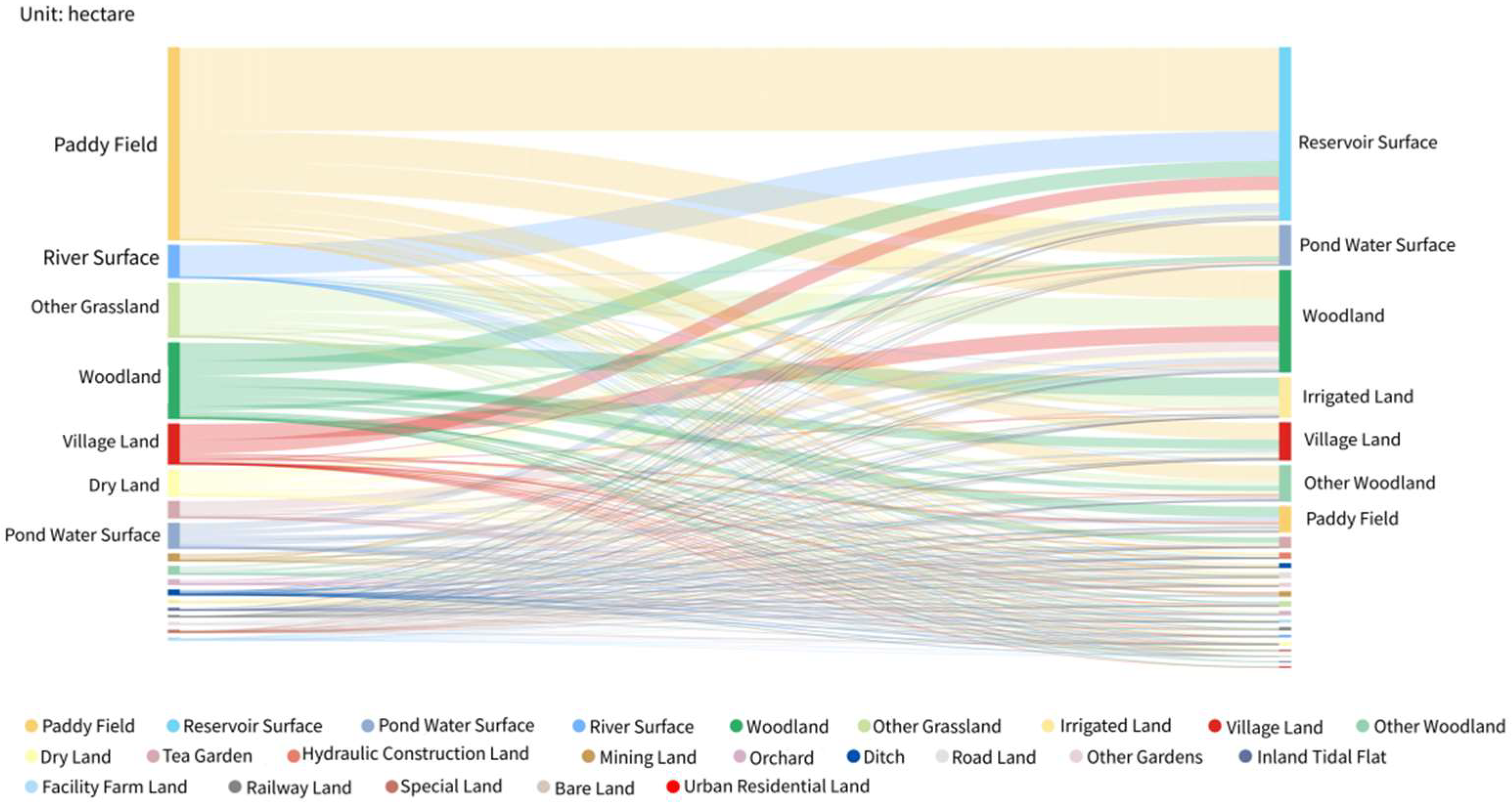
3.2.2. Reinforce Attention: Building Reservoirs at the Expense of Cultivated Land

The main-body construction stage for the construction of the large reservoir was from 2014 to 2017, during which the local government significantly prioritized its focus on the construction of the large reservoir. This focus has been further strengthened by the local government’s continued efforts to enhance the ARC, which has direct implications for the ACP. Notably, there is a strong negative correlation coefficient (−0.93) between changes in ARC and changes in ACP during this period. This means that the higher the intensity of the local government’s focus on ARC, the lower the ACP. In particular, in 2016 when the ARC peaked at 11.39%, the ACP accounted for only 2.72%. Consequently, the shifting attention of the local government towards prioritizing the construction of large reservoirs has directly influenced their decision-making process, leading them to prioritize completing the construction planning of these reservoirs at the cost of cultivated lands in their land-use adjustments.
According to the results of the land-use structure adjustment, the paddy fields transferred out are mainly used for water surface land of the reservoir, accounting for 43.31% of the paddy fields transferred out. The water surface of the reservoir mainly comes from paddy fields and rivers, accounting for 48.36% and 17.37% of the newly increased area of the reservoir. In addition, 92.67% of the reduced river water surface land is converted to the reservoir water surface. However, as the main grain production cultivated land in the study area, the quality of paddy fields distributed along the river is often better. Therefore, the local government chose to give priority to completing the construction planning of the large reservoir, sacrificed some high-quality cultivated land, and planned the reservoir inundation area along the river flow direction. This decision has brought challenges and crises for local governments to carry out RLCCP. The other types of transferred out-land do not exceed 20%.

3.2.3. Adjust Attention: Scale of Supplementary Cultivated Land

From 2017 to 2020, the local government has readjusted its focus. The emphasis has shifted to the construction of the large reservoir, specifically the Opening Sluice Water Storage Stage, with the Agricultural Cultivated-Land Protection (ACLP) gradually being de-emphasized. As a result of completing the main reservoir construction, the local government has reduced the ARC by 2.78% and shifted its attention primarily to cleaning the reservoir bottom. Interestingly, the local government has placed slightly more attention on cultivated-land protection compared to reservoir construction, by 0.91%. It is worth noting that since 2017, there has been a significant increase in the local government’s attention to Immigration-development Assistance (AIA). In 2019, this peaked at 10.23%, focusing on fund allocation, community management, civilized guidance, and employment assistance for immigrants. This adjustment in attention, following the completion of the main reservoir works, has led the local government to decide to supplement the scale of cultivated land rather than significantly increase land for reservoir construction during the land-use adjustment process.
The increase in cultivated-land-use scale in the study area mainly comes from agricultural land (forest land) and unused land (other grasslands), accounting for 42.75% and 19.80% of the increase in cultivated land, respectively. Among them, the newly increased cultivated land is mainly irrigated land and paddy fields, accounting for 59.13% and 37.78% of the increased cultivated land. The increase of irrigated land has changed the structure of cultivated-land use in the study area, surpassing dry land as the second largest type of cultivated-land use. The proportion of paddy fields, dry land, and irrigated land has changed from 170:14:1 in 2009 to 20:1:3. Therefore, the increase in irrigated land has effectively alleviated the imbalance in the amount of cultivated land, contributing to the positive results achieved through readjusted attention by local governments in addressing the issue.

3.2.4. Divert Attention: Negative Impact of Newly Cultivated Land

During the Completion Acceptance Stage of the construction of the large reservoir from 2020 to 2022, the negative impacts on the newly cultivated land have not been completely resolved. One issue is the decline in the quality of cultivated land in the study area. The process of land-use adjustment from 2009 to 2019 revealed that local governments took over a significant amount of paddy fields to build reservoirs. Although a large amount of irrigated land was subsequently added, the overall quality of the cultivated land in the study area decreased. Additionally, a new problem of cultivated-land abandonment has emerged. Despite the land-use adjustment, more than half of the newly cultivated land remains uncultivated, with some types of land reaching abandonment rates exceeding 80% after the transition to irrigated land. This phenomenon is related to the agglomeration of village construction land following the relocation of reservoir area immigrants (Figure 5). Due to the abandonment of cultivated land by immigrants and their relocation to the resettlement areas built by local governments, only 13.48% of immigrants continue to engage in agricultural work after relocation. Consequently, the construction of the large reservoir not only increases the extent of agglomeration for village construction land but also reduces the proportion of reservoir immigrants involved in agricultural work. It has also been observed that the rate of newly cultivated-land abandonment, particularly for newly irrigated land, increases with distance from the village construction land. In the buffer zone located 50 m to 350 m away from the village construction land, the rate of newly irrigated land abandonment ranges from 34.65% to 65.85%.
The average annual growth rate of AIA of local governments at this stage is 0.11% higher than that of ACP. This indicates that as the reservoir construction comes to an end, the local government is shifting its focus toward the management of immigrant communities, employment assistance, mental outlook, and other aspects of development assistance. Additionally, more attention is being given to solving the feedback problems related to cultivated-land protection from superior supervisors, investigating and handling cases of illegal occupation of cultivated land, and soil pollution control. However, there is no effective attention being given to RLCCP’s “Continuous negative impact”—the decline in the quality of newly cultivated land and abandonment.

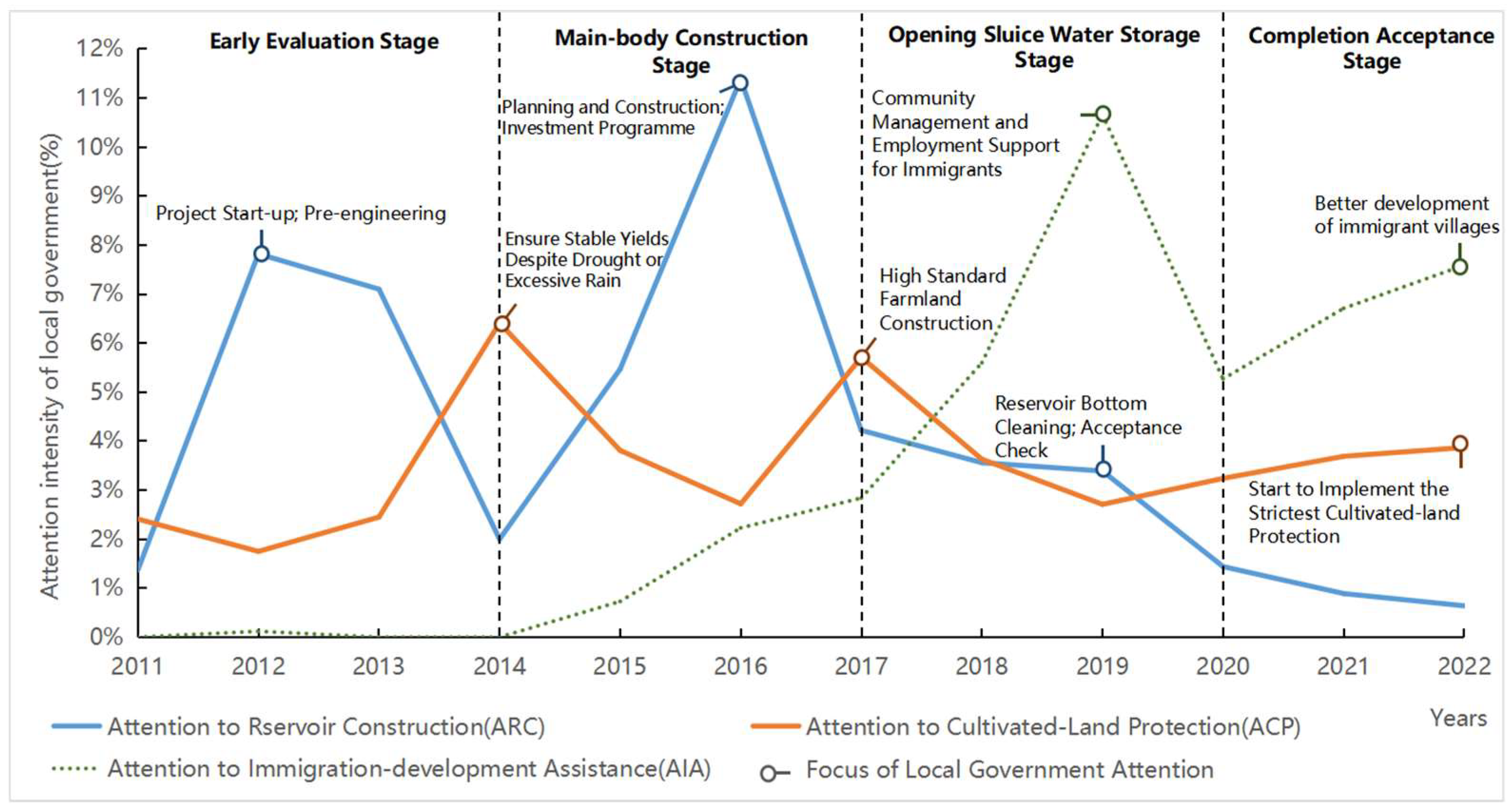
3.3. RLCCP Evolution Mechanism from the Perspective of Local Government

The development process of RLCCP during the construction of large reservoirs is influenced by the attention trend of local governments. The local government’s attention to the “Create-Reinforce-Adjust-Divert” large reservoir construction leads to various rebalancing efforts aimed at mitigating the impact on cultivated land. These rebalancing efforts undertaken by local governments can be categorized into four stages: “Generation—Challenge—Marked effect—Continuous negative impact” (GCMC), resulting in different outcomes in land-use adjustment. To understand the evolution mechanism of RLCCP, it is necessary to analyze the driving factors and decision-making purposes of local governments in land-use decision-making at different stages of large reservoir construction (Figure 6).

3.3.1. Create Attention: Generation Period of RLCCP

On the one hand, local governments, as administrative subordinate organs established by the central government, must obey and fulfill the goals and requirements of the central government. Thus, when the country faces the national demand for Huaihe River governance and water for people’s livelihood, the central government assigns the task of “large reservoir construction” to the local governments. Consequently, the administrative management system and the land state-owned system require the local government to take immediate action upon accepting the task. This prompt response creates the “ARC” in the study area. Additionally, the requirement of cultivated-land protection is also a long-term top-down task. Therefore, the local government needs to continuously pay attention to cultivated-land protection during the reservoir construction period, resulting in a continuous ACP. Moreover, local governments must build large reservoirs.
The status of cultivated-land protection in the performance appraisal is more similar to the “thankless” work, thus leaving many hidden dangers for the work of cultivated-land protection. On the other hand, factors such as the implementation of the important tasks of the superior and the efficiency of completion are not only the standard of the daily performance appraisal of the government but also the typical political achievement of “breaking through the tight encirclement” in the performance appraisal of the local government. The typical practices of the local government in the study area during the planning and construction of large reservoir and resettlement areas have been visited, investigated, and studied by the superior government and other local governments in the reservoir area as excellent cases many times. The resettlement work has won the third-class collective credit three times, and won the title of “Top Ten Influential Water Conservancy Projects in China”.
Therefore, based on the requirements of China’s administrative management system and the land state-owned system, the local government maintains an “optimistic” attitude toward the future advantages brought by the construction of large-scale water conservancy infrastructure. This is primarily driven by the consideration of improving the local government’s political achievements. To achieve this, the local government created the ARC program, which focuses on selecting large reservoir construction projects that can bring significant political achievements. However, it is also recognized by the local government that the construction of large-scale infrastructure can lead to various issues related to land utilization. Therefore, the local government has adopted a comprehensive approach that emphasizes the protection of cultivated land while addressing these issues and has implemented a series of rebalancing measures.

3.3.2. Reinforce Attention: Challenge Period of RLCCP

With the development of large reservoir construction, the local government’s self-interest appeal is highlighted, which intensifies RLCCP in implementing the strategy of “Strategies for Scramble Funds through Projects” and expanding the source of tax revenue. Finance and taxation are the core elements for local governments to seek their interests. Local government decision-making is a rational choice between the explicit achievements of project construction and the implicit achievements of cultivated-land protection. However, local governments in villages and towns often find it difficult to achieve financial self-sufficiency. Driven by the project system governance in China, large reservoir construction projects, as state-level projects, have led the local government to focus more attention and energy on exploring derivative projects that can rely on large reservoir construction. To seek superior financial support, the local government further strengthened ARC. As a result, the resettlement area in the reservoir area has become a new “Cornucopia”, which is used as a bargaining chip to compete with the superior government, compete with the same level government, and successfully obtain nearly 15 million special financial allocations from the superior government.
The local government in the study area has chosen to expand the area of construction land by occupying cultivated land to support large reservoir construction and resettlement projects. This decision was made to cultivate tax subjects and support backbone tax sources. On one hand, the government obtains land finance tax through land acquisition, land transfer, and land development. On the other hand, it attracts investment through the construction of large reservoirs and resettlement areas. As a result, the average annual tax revenue in the study area has increased from 5.3083 million yuan/year to 12.5133 million yuan/year since 2019, demonstrating the success of land management decision-making. However, this has also led to an increase in demand for Public Complaints and Proposals (PCP) from local residents and immigrants. During the Early Evaluation Stage, only 1.01% attention was given to PCP by the local government in the reservoir area for the construction of the large reservoir. However, as the main-body construction stage commenced, the local government started paying closer attention to PCP, raising the degree of attention to 3.41%. This mainly pertains to land disputes in resettlement, land acquisition, and production land adjustment.
The local government has focused on large reservoir construction projects as a means to achieve significant financial benefits, making it one of the interesting subjects of RLCCP. However, the implicit achievement of cultivated-land protection has contributed minimally to local financial growth. Consequently, the decision to occupy cultivated land for the construction of a large reservoir and resettlement area was made by the local government to meet its financial interests. As a result, the rebalancing efforts of the local government are facing challenges and crises.

3.3.3. Adjust Attention: Marked Effect Period of RLCCP

The local government of the study area has implemented a series of measures, such as “Supplementary cultivated land”, “Land reception”, and “Control of soil pollution”, by the requirements of “Basic cultivated-land protection”, “the red line for the protection of cultivated land”, “cultivated-land balance”, and “Increase and decrease connection of land”. These measures were taken to fulfill the tasks and requirements stipulated by the central government through land management laws and policies, to protect the quantity of cultivated land. In addition, from 2017 to 2019, intensive efforts were made in the “Production land adjustment of immigrant” work, resulting in the resettlement of 12,978 people for production purposes and the transfer of 26.28 hectares of land. These actions have to some extent met the production land demand of some immigrants. The rigid constraints of the Cultivated-land Protection Requirements and the supervision constraints of the Land Public Complaints and Proposals System have prompted local governments to confront the crisis of cultivated-land loss.
Residents in the study area have repeatedly exercised the right to supervise the land acquisition process from the bottom up to the local government through PCP. At the stage of impoundment, the local government proposed to carry out the “PCP Responsibility Implementation Year” activity in depth, focusing on the PCP stabilization of reservoir demolition cases. Resolving problems related to reservoir construction accounted for 86% of the total PCP in the township. Furthermore, the local government mediated nearly a thousand conflicts and disputes caused by reservoir construction and successfully resolved nearly a hundred resettlement problems.
In the process of land-use adjustment, the top-down cultivated-land management policy rigidly restricts the behavior of local governments to occupy cultivated land based on their interests. This, in turn, affects the effectiveness of the bottom-up mass supervision mechanism, which also restricts local governments. To stabilize social governance, local governments have prioritized the protection of cultivated land and carried out supplementary works to alleviate challenges faced during previous rebalancing efforts. However, the local government’s attention has mostly been focused on increasing the quantity of cultivated land rather than ensuring its quality, resulting in insufficient supervision. Consequently, the study area has experienced a decline in the quality of cultivated land as a result of the decrease in paddy fields and the increase in irrigated land.

3.3.4. Divert Attention: Continuous Negative Impact Period of RLCCP

The local government’s commitment to the construction of large reservoir projects, such as the RLCCP, has helped maintain the regional land balance. However, this initiative has also resulted in detrimental consequences, primarily the decline in the quality of newly cultivated land and widespread abandonment. Currently at the Completion Acceptance Stage, the construction of large reservoirs has diverted the local government’s attention away from safeguarding cultivated land due to its Ambition for Local Development and the Willingness of Immigrants for Employment.
With the construction of the large reservoir nearing completion, the local government has demonstrated its ambitions for local development in various sectors such as economy, tourism, and culture, with the large reservoir acting as the primary focal point. The aim is to utilize the resources surrounding the large reservoir, utilizing the immigrant village as the main spatial carrier, and leveraging regional advantages to establish a vibrant town that encompasses healthcare, vacationing, leisure, culture, and sports. The goal is to create an appealing and livable home suitable for residents, workers, and tourists alike. Simultaneously, the local government takes proactive measures to guide immigrants in finding employment and engaging in entrepreneurial activities in their respective hometowns. To transform the perception of migrant employment, it is crucial to develop a comprehensive migration education and training system, which emphasizes professional skill-building and quality education. Moreover, to expand employment opportunities for immigrants, the government has planned and constructed an immigrant entrepreneurship park, which has successfully attracted over ten enterprises. Additionally, the government encourages immigrants to actively participate in the development of the tourism industry by providing guidance and support in establishing services such as homestays and farmhouses, thus promoting the growth of tertiary industries.
The local government in the study area has aspirations for the future development of the region and the immigrants residing there. They aim to utilize the resources of the large reservoir, devise plans for tourism development, and stimulate the growth of catering, accommodation, and other service industries to enhance the income of immigrants. However, this ambitious outlook surpasses the realm of existing infrastructure construction and the prevailing business environment conditions in the region, resulting in a conflict between reality and the local government’s aspirations. A survey conducted highlighted that in 2022, the primary employment intentions of migrants will still be in the realm of migrant work, with only 7.52% of migrants engaged in tourism-related activities. Although more than 60% of the migrants possess the necessary time, capital, and energy to participate in the tourism industry, a significant majority (74.61%) still perceive engagement in the tourism industry as difficult and risky. Moreover, the local government does not prioritize the cultivation of new farmland, the migrants residing after relocation are far removed from cultivated land, and the remaining households who did not relocate are relatively older (43.89% of farmers are over 50 years old). Consequently, after relocation, most migrants neither involve themselves in tourism work as desired by the local government nor return to large-scale farming on cultivated land, which further exacerbates the “Negative Impact of New Cultivated Land” that remains unresolved by RLCCP.

4. Discussion

Cross-disciplinary solutions have become the main trend of current research in addressing issues such as functional conflict, quantity imbalance, and space occupation in the adjustment of land-use structure [37]. The attention perspective, which focuses on government decision-making, holds theoretical significance in explaining the process and mechanism of land-use rebalancing. It also offers a new analytical perspective and interpretation method for research in this field. In the analysis, the question of whether “people and land” can develop harmoniously and uniformly involves various phenomena in land use such as function conflict, quantity imbalance, and space occupation [38]. Tracking the process and dynamic changes in land use is crucial in addition to focusing on the outcomes of land-use adjustment [39]. The decision-making of stakeholders is closely linked to the process and dynamic change of land use. Previous research on land-use structure adjustment primarily regarded the government or its policies as one of the influencing factors, considering local government decision-making as only a part of the outcomes of land-use adjustment [40,41]. Consequently, this study aims to address this gap by examining land use from the perspective of the local government as a stakeholder, providing a more comprehensive understanding of the influencing factors, decisions, and objectives of the local government in land-use structure adjustment. Furthermore, this study elucidates the strategies employed by the government to achieve land-use rebalancing, which serves to compensate for the limitations in the analysis of policy influencing factors resulting from restricted land spatial use data acquisition time and varying resolution quality. Moreover, this approach facilitates a deeper-level analysis of the thought process and actions of interest subjects in the “rebalancing” process. Government decision-making in the process of land-use adjustment involves decentralized information [42]. In the analysis process, the government’s attention perspective, through text analysis, tends to focus on comprehensive texts and coherent timelines. This includes government official documents, government news, and meeting minutes. These texts not only summarize and analyze past work content and planning schemes [43,44], but also organize and plan future work. This perspective aids in understanding the process and future trends of land-use structure adjustment from a “planner” perspective.
The evolution of RLCCP is a land-use rebalancing scheme with Chinese characteristics. To understand and practice RLCCP, this article discusses its evolution mechanism from the perspective of local government. It combines specific construction cases with current research on land-use function conflict and spatial adjustment of “construction land and cultivated land”. This helps to provide Chinese ideas and plans for local governments. First, the process of land-use change involves the increase in construction land and a reduction in cultivated land due to the construction of large infrastructure. Similar to construction land expansion, cultivated land is also sacrificed for expansion. In this article, the process of land-use structure change is consistent with the conclusions of the existing research on “construction land and cultivated-land change” [45,46]. Second, the underlying reason for local governments to rebalance land use is the conflict between stakeholders [19]. This study explains that the central government assigns large infrastructure tasks to local governments to fulfill national needs and public interests. Meanwhile, local governments take this opportunity to achieve their own performance and financial interests. In this process, local governments carry out rebalancing efforts. Lastly, the strategy for land-use rebalancing efforts is influenced by top-down rigid land constraints and bottom-up mass supervision constraints [39]. This study verifies the “resolution” stage of land-use conflict as the ultimate goal. As a type of construction land, large infrastructure land shares similarities with other construction land structure adjustments. However, large infrastructure construction led by local governments has characteristics such as wide area coverage, involvement of many people, and complex land types. These factors make government policy changes closely related to land-use evolution. The local government supplements the number of cultivated land and carries out “Production land adjustment of immigrant” work to mitigate the imbalance caused by construction land occupation. Based on previous studies, this study focuses on the construction stage of large infrastructure and explains the decision-making focus, reasons, and results of land-use changes caused by local governments at different stages. This forms a cultivated-land evolution model of “balance–imbalance–rebalance” under the influence of multiple factors.
After the local government has conducted land-use rebalancing efforts, there is still a certain “continuous negative impact”—the low quality of newly cultivated land and the abandonment problem. The low quality of supplementary cultivated land shows that the local government does not pay enough attention to the protection of cultivated land quality. This is due to China’s cultivated-land protection system’s focus on protecting the quantity of cultivated land rather than its quality. The lack of a complete and systematic set of laws and regulations on cultivated-land protection, as well as a lack of incentives and requirements for cultivated-land quality protection, contribute to this problem [47,48]. The local government’s priority is on how to supplement the quantity of cultivated land, disregarding the quality of cultivated land after large-scale infrastructure construction. Consequently, this results in challenges to food security as it leads to the problems of “being unable to abide by” and “lax law enforcement” in the process of cultivated-land protection by the local government. The problem of newly cultivated-land abandonment is related to the inadequate consideration of the local government’s newly cultivated-land and village location planning. Previously, Qiu et al. found that village location and accessibility significantly impact cultivated-land abandonment. In this study, it is further revealed that the local government’s practice of combining resettlement construction with the planning of the new area has promoted urban-rural integration. However, the distance between the newly cultivated land and the village has not been fully considered in the planning process, resulting in the abandonment of most of the newly cultivated land [49]. To address these issues, improving the assessment mechanism of cultivated-land protection and strengthening the assessment of cultivated-land quality protection levels is crucial. Promulgating the Cultivated-Land Protection Law and implementing other measures would urge and encourage local governments to prioritize the protection of cultivated-land quality during the large-scale infrastructure construction process.

5. Conclusions

This study discusses a series of land-use rebalancing efforts made by the local government in the reservoir area under multiple driving factors and the resulting land-use adjustment results, based on the perspective of government attention. The main conclusions are as follows: First, the impact of large infrastructure construction on cultivated land objectively exists. In rural areas, the sharp decrease of cultivated land and the increase of large infrastructure land occur simultaneously during the process of land-use structure adjustment. In countries with public ownership of land, priority is given to large infrastructure construction projects that promote national development and social stability. Local governments tend to sacrifice cultivated land in favor of large infrastructure construction, with subsequent efforts made to establish new cultivated land. Second, local governments focus on the “Wind vane” of regional land-use structure adjustment. The issues that receive more attention from local governments during large infrastructure construction serve as a basis for government decision-making. This directly influences the planning ideas of local governments for regional land-use adjustment, resulting in a targeted land-use structure adjustment plan at different stages of large infrastructure construction. Finally, the land-use adjustment decision resulting from changes in the local government’s attention represents a series of land-use rebalancing efforts with Chinese characteristics, as a subject of interest in land-use. Driven by goals such as Local Government Political Achievement, Local Financial Interests, Local Social Stability, and Local Regional Development, local governments make land-use adjustment decisions to intensify their interests and development. Through various means, these local governments supplement cultivated land and adjust productive land, attempting to achieve a balance between large-scale infrastructure construction and cultivated-land protection objectives through rebalancing efforts.

6. Prospect

From the perspective of government attention, this study has limitations on RLCCP research. On one hand, the NLP analysis reveals that local governments will continue to prioritize cultivated-land protection and food security from 2020 to 2022. However, the land survey data used in the analysis only covers 2009 and 2019, restricting the ability to examine the process of land-use structure adjustment. Thus, future research should monitor the adjustment and changes in land-use structure after 2020, and explore the impacts of improved ACP on land-use structure. On the other hand, existing research on government attention typically relies on semantic coding of government work reports, news, and other texts, quantifying the proportion of texts related to the research topic as an indicator of attention intensity changes. To provide a more comprehensive and objective representation of government decision-making attention trends, it is recommended that future studies explore alternative methods of quantifying government attention and consider diverse data acquisition channels.

Author Contributions

Conceptualization, J.G.; Investigation, Z.M., J.S. and Y.G.; Data curation, X.Z., C.Y., Z.M., J.S. and Y.G.; Writing—original draft, J.G. and X.Z.; Writing—review and editing, C.Y. All authors have read and agreed to the published version of the manuscript.

Funding

This research was funded by the National Natural Science Foundation of China (U1904125); Scientific and Technological Innovation Talents in Colleges and Universities of Henan Province in China (2021-CX-027); Soft Science Project of Science and Technology of Henan Province (222400410186); Nanhu Scholars Program of XYNU (2022).

Data Availability Statement

The rural land-use data in the study area is obtained from the second and third national land survey databases. At present, it is only used for research and is not fully disclosed. All government work reports can be retrieved on the official website and are fully disclosed.

Conflicts of Interest

The authors declare no conflict of interest.

References

  1. FAO; IFAD; UNICEF; WFP; WHO. The State of Food Security and Nutrition in the World 2022. Repurposing Food and Agricultural Policies to Make Healthy Diets More Affordable; FAO: Rome, Italy, 2022. [Google Scholar] [CrossRef]
  2. Song, J.; Ye, J.; Zhu, E.; Deng, J.; Wang, K. Analyzing the impact of highways associated with cultivated-land loss under rapid urbanization. ISPRS Int. J. Geo Inf. 2016, 5, 94. [Google Scholar] [CrossRef]
  3. Liang, X.Y.; Jin, X.B.; Sun, R.; Han, B.; Ren, J.; Zhou, Y.K. China’s resilience-space for cultivated-land protection under the restraint of multi-scenario food security bottom line. Acta Geogr. Sin. 2022, 77, 697–713. (In Chinese) [Google Scholar] [CrossRef]
  4. Xiong, C.; Beckmann, V.; Tan, R. Effects of infrastructure on land use and land cover change (LUCC): The case of Hangzhou International Airport, China. Sustainability 2022, 10, 2013. [Google Scholar] [CrossRef]
  5. Cao, Y.; Zhou, W.; Wang, J.; Yuan, C. Spatial-temporal pattern and differences of land use changes in the Three Gorges Reservoir Area of China during 1975–2005. JMS 2011, 8, 551–563. [Google Scholar] [CrossRef]
  6. Yan, J.; Xiao, R.; Su, F.; Bai, J.; Jia, F. Impact of Port Construction on the Spatial Pattern of Land Use in Coastal Zones Based on CLDI and LUT Models: A Case Study of Qingdao and Yantai. Remote Sens. 2021, 13, 3110. [Google Scholar] [CrossRef]
  7. Yang, S.Q.; Zhu, G.R.; Liu, J.; Tu, H.L. The Research Progress of the Traffic Ecological Effects under the Perspective of “Pattern-Process-Function”. Ecol. Environ. Sci. 2022, 31, 634–642. (In Chinese) [Google Scholar] [CrossRef]
  8. Wang, Y.N.; Shi, P.J.; Liu, C.F.; Zhang, X.B.; Xu, Y.L. Potential Land Use Competition Risk ldentification in Rapid Agglomeration City-A Case Study of Lanzhou New District. Resour. Dev. Mark. 2016, 32, 1415–1419. [Google Scholar] [CrossRef]
  9. Bai, L.M.; Feng, X.H.; Sun, R.F.; Gao, H. Spatial and temporal responses of habitat quality to urbanization: A case study of Changchun City, Jilin Province, China. Chin. J. Appl. Ecol. 2020, 31, 1267–1277. [Google Scholar] [CrossRef]
  10. Zhao, J.; Gao, Z.L.; Cai, Y.R. Impacts of Expressway Construction on Land Use Types and Assessment on the Ecosystem Service Value—A Case Study of Five Typical Areas in Shaanxi Province. Res. Soil Water Conserv. 2011, 18, 226–231+237. [Google Scholar]
  11. Guo, H.L.; Zhou, Q.G. Effect of Land Use Change on Ecosystem Service Value Pre and Post the Water Storage in the Three Gorges Reservoir Area. Res. Soil Water Conserv. 2016, 23, 222–228. (In Chinese) [Google Scholar] [CrossRef]
  12. Siciliano, G.; Urban, F. Equity-based natural resource allocation for infrastructure development: Evidence from large hydropower dams in Africa and Asia. Ecol. Econ. 2017, 134, 130–139. [Google Scholar] [CrossRef]
  13. Xu, Z.M. Research on Land Use Conflict Management Based on Stakeholder Theory; Zhejiang University: Hangzhou, China, 2011. (In Chinese) [Google Scholar]
  14. Ruan, S.T.; Wu, K.N. Research of the Land Use Conflict and Mitigation Mechanism During the Urbanization in China. China Popul. Resour. Environ. 2013, 23 (Suppl. S2), 388–392. [Google Scholar]
  15. Yu, B.H.; Lv, C.H. The Progress and Prospect of Land Use Conflicts. Prog. Geogr. 2006, 25, 106–115. (In Chinese) [Google Scholar]
  16. Zhou, D.; Xu, J.C.; Wang, L. Process of Land Use Conflict Research in China During the Past Fifteen Years. China Land Sci. 2015, 29, 21–29. (In Chinese) [Google Scholar] [CrossRef]
  17. Bergius, M.; Benjaminsen, T.A.; Maganga, F.; Buhaug, H. Green economy, degradation narratives, and land-use conflicts in Tanzania. World Dev. 2020, 129, 104850. [Google Scholar] [CrossRef]
  18. Sabir, M.; Torre, A. Land-Use Conflicts and Social Capital: The question of infrastructure projects in rural development. Ann. Reg. Sci. 2020, 70, 757–777. [Google Scholar] [CrossRef]
  19. Wang, Y.; Li, P.Z.; Wang, H.Y.; Shao, X.D.; Li, Y. Evolution of land use conflicts and their stakeholders’ contradiction and combination relationship in Northeast China. J. Arid Land Resour. Environ. 2021, 35, 65–70. (In Chinese) [Google Scholar] [CrossRef]
  20. Magsi, H.; Sabir, M.; Torre, A.; Chandio, A.A. Management practices to minimize land use conflicts on large-infrastructure projects: Examples of dams construction in Pakistan. Geosci. J. 2021, 87, 4851–4861. [Google Scholar] [CrossRef]
  21. Sardaro, R.; Faccilongo, N.; Roselli, L. Wind farms, cultivated-land occupation and compensation: Evidences from landowners preferences through a stated choice survey in Italy. Energy Policy 2019, 133, 110885. [Google Scholar] [CrossRef]
  22. Padeiro, M. Conformance in land-use planning: The determinants of decision, conversion and transgression. Land Use Policy 2016, 55, 285–299. [Google Scholar] [CrossRef]
  23. Blizzard, A.F.; Mangun, W.R. Intergovernmental influences on the implementation of coastal zone management in the United States: Public shoreline access in the Southeast. Ocean. Coast Manag. 2008, 51, 443–449. [Google Scholar] [CrossRef]
  24. Kondolf, G.M.; Lopez-Llompart, P. National-local land-use conflicts in floodways of the Mississippi River system. AIMS Environ. Sci. 2018, 5, 47–63. [Google Scholar] [CrossRef]
  25. Klauer, B.; Küblböck, K.; Omann, I.; Karutz, R.; Klassert, C.; Zhu, Y.; Zozmann, H.; Smilovic, M.; Talozi, S.; Figueroa, A.J.; et al. Stakeholder Workshops Informing System Modeling—Analyzing the Urban Food–Water–Energy Nexus in Amman, Jordan. Sustainability 2022, 14, 11984. [Google Scholar] [CrossRef]
  26. Shi, X.J. Study on the Evaluation of the Implementation of General Land Use Planning; Jiangsu University of Science and Technology: Zhenjiang, China, 2020; pp. 27–30. (In Chinese) [Google Scholar] [CrossRef]
  27. Gui, H. Practical Balance in the Relationship between Central and Local Governments: An Analysis with Special Reference to Land Management Practice. Open Times 2022, 92–106. (In Chinese) [Google Scholar]
  28. Xia, Z.Z. Land system reform from the perspective of national governance. Seeker 2020, 143–150. (In Chinese) [Google Scholar] [CrossRef]
  29. Zhang, Y.M. Study on the Transformation and Countermeasures of cultivated-land Protection System-Construction of The Incentive System of Protection of cultivated-land. Chin. J. Agric. Resour. Reg. Plan. 2014, 35, 26–31. [Google Scholar]
  30. Xie, L.L.; Xu, J.L.; Zang, J.M.; Huang, T.N. Simulation and Prediction of Land Use Change in Guangxi Based on Markov—FLUS Model. Res. Soil Water Conserv. 2022, 29, 249–254 + 264. (In Chinese) [Google Scholar] [CrossRef]
  31. Simon, H.A. Administrative Behavior: A Study of Decision-Making Processes in Administrative Organi-Zation; Macmillan: New York, NY, USA, 1997. [Google Scholar]
  32. Bai, D. Research on Simon’s Limited Rational Decision-Making Thought; Dalian Maritime University: Dalian, China, 2017; pp. 21–22. (In Chinese) [Google Scholar]
  33. Xu, J.; Lu, L.D.; Wei, J.C. Hierarchical difference in attention allocation of local Governments: Explaining change and stability in safety management. Safety Sci. 2022, 152, 105789. [Google Scholar] [CrossRef]
  34. Gao, J.B.; Liu, Y.S.; Zhang, Y.X. Evolution of Temporal-spatial Pattern of Grain Production and Its Driving Mechanism in Huaihe River Basin During 1990–2012. Bull Soil Water Conserv. 2016, 36, 179–185+192. (In Chinese) [Google Scholar] [CrossRef]
  35. Huang, W.H. Legal interpretation of the State Council government work report and its constitutional connotation. Huxiang Forum. 2020, 33, 94–104. (In Chinese) [Google Scholar]
  36. Tuan, Y.F. Geography, phenomenology and the study of human nature. TCG 1971, 15, 181–192. [Google Scholar] [CrossRef]
  37. Innocenti, E.; Detotto, C.; Idda, C.; Parker, D.C.; Prunetti, D. An iterative process to construct an interdisciplinary ABM using MR POTATOHEAD: An application to Housing Market pattenls in touristic areas. Ecol. Complex 2020, 44, 100882. [Google Scholar] [CrossRef]
  38. Yang, Y.F.; Zhu, L.Q. The Theory and Diagnostic Methods of Land Use Conflicts. Res. Sci. 2012, 34, 1134–1141. [Google Scholar]
  39. Zou, L.L.; Liu, Y.S.; Wang, Y.S. Research Progress and Prospect of Land-use Conflicts in China. Prog. Geogr. 2020, 39, 298–309. (In Chinese) [Google Scholar] [CrossRef]
  40. Liu, Y.; Li, J.; Yang, Y. Strategic adjustment of land use policy under the economic transformation. Land Use Policy 2018, 74, 5–14. [Google Scholar] [CrossRef]
  41. Zeng, L.; Li, H.; Wang, X.; Yu, Z.; Hu, H.; Yuan, X.; Zhao, X.; Li, C.; Yuan, D.; Gao, Y.; et al. Chinas Transport Land: Spatiotemporal Expansion Characteristics and Driving Mechanism. Land 2022, 11, 1147. [Google Scholar] [CrossRef]
  42. Steinhäußer, R.; Siebert, R.; Steinführer, A.; Hellmich, M. National and regional land-use conflicts in Germany from the perspective of stakeholders. Land Use Policy 2015, 49, 183–194. [Google Scholar] [CrossRef]
  43. Wu, Y.S. Research on the Impact of Microblog Public Opinion on Government Attention Distribution; Huazhong University of Science and Technology: Hangzhou, China, 2019. (In Chinese) [Google Scholar] [CrossRef]
  44. Brasil, F.G.; Bichir, R. Policy Dynamics and Government Attention over Welfare Policies: An Analysis of the Brazilian Case. Braz. Political Sci. Rev. 2022, 16, e0007. [Google Scholar] [CrossRef]
  45. Wang, A.F.; Chen, S.H.; Wei, Y.Z.; Tang, X.L.; Dai, J.F. Land Use Conflict Based on F-H Method in theLijiang River Basin, China. J. Mount. Sci. 2021, 39, 506–514. (In Chinese) [Google Scholar] [CrossRef]
  46. Wang, J.J.; Wu, Z.P.; Wang, S.S.; Yin, H.H. An Analysis of The Pattern of Land-Use Conflicts in Valley Oases in Arid Areas. Remote Sens. Nat. Resour. 2021, 33, 243–251. [Google Scholar] [CrossRef]
  47. Shen, X.; Wang, L.; Wu, C.; Lv, T.; Lu, Z.; Luo, W.; Li, G. Local interests or centralized targets? How Chinas local government implements the cultivated-land policy of Requisition–Compensation Balance. Land Use Policy 2017, 67, 716–724. [Google Scholar] [CrossRef]
  48. Ren, D.P.; Peng, B. Research on the Rule of Legal Regulation to Prevent “Non-grain” of cultivated-land. China Land Sci. 2022, 36, 1–9. (In Chinese) [Google Scholar] [CrossRef]
  49. Qiu, Y.; Cao, G. The Heterogeneous Effects of Multilevel Location on cultivated-land Abandonment: A Village-Level Case Study in Taian City, China. Land 2022, 11, 1233. [Google Scholar] [CrossRef]
Figure 1. The relationship between land-use data and NLP data.
Land 12 01632 g001
Figure 2. Land use in the study area from 2009 to 2019.
Land 12 01632 g002
Figure 3. Changes in government attention intensity from 2011 to 2022.
Land 12 01632 g003
Figure 4. Land-use transfer in the study area from 2009 to 2019.
Land 12 01632 g004
Figure 5. Abandonment degree of newly added cultivated land in the construction land buffer zone of different villages.
Land 12 01632 g005
Figure 6. RLCCP evolution mechanism from the perspective of local government attention.
Land 12 01632 g006
Table 1. Classification of land-use status.
Land Category Name Land Category Name
Agricultural LandPaddy FieldConstruction LandMining Land
Irrigated LandUrban Residential Land
Dry LandVillage Land
OrchardSpecial Land
Tea GardenRailway Land
Other GardensRoad Land
WoodlandReservoir Surface
Other WoodlandHydraulic Construction Land
Pond Water SurfaceUnused LandOther Grassland
DitchRiver Surface
Facility Agricultural landInland Tidal Flat
Bare Land
Disclaimer/Publisher’s Note: The statements, opinions and data contained in all publications are solely those of the individual author(s) and contributor(s) and not of MDPI and/or the editor(s). MDPI and/or the editor(s) disclaim responsibility for any injury to people or property resulting from any ideas, methods, instructions or products referred to in the content.

