


War and Deforestation: Using Remote Sensing and Machine Learning to Identify the War-Induced Deforestation in Syria 2010–2019


Abstract
1. Introduction
2. Materials and Methods
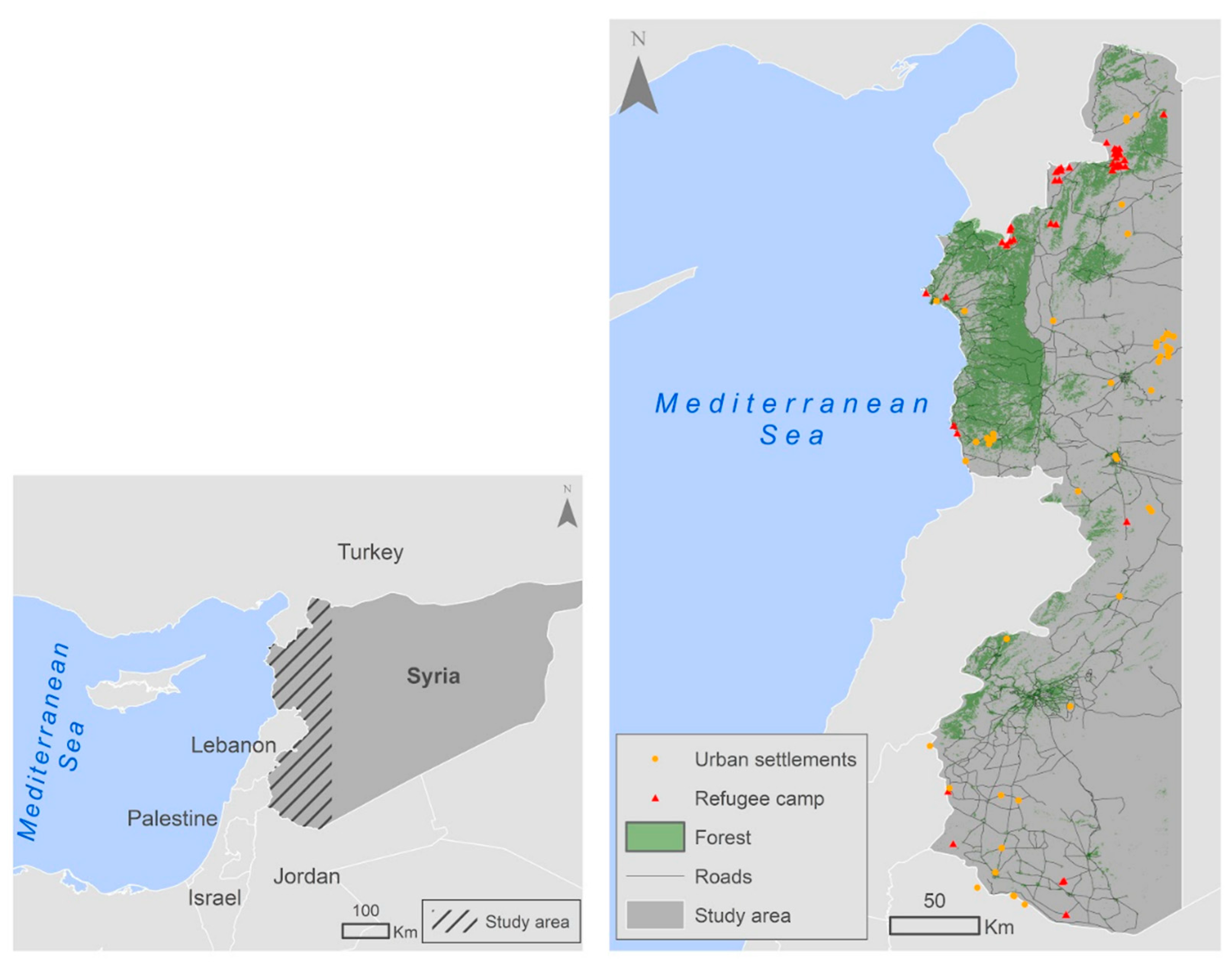
2.1. The Study Area
2.1.1. Location
2.1.2. Climate
2.1.3. Forests
- Most of the forest cover in Syria is located in the western coastal mountains, which are divided into two parts due to the variation of precipitation that they receive annually:
- The western part, ranges between 0 and 1570 m above sea level, with dominant species such as Quercus calliprinos, Pistacia palaestina, Abies cilicica, Ceratonia siliqua, Pistacia lentiscus, and Quercus infectoria.
- The eastern part ranges between 300 and 1570 m above sea level, with dominant species such as Quercus calliprinos, Pistacia palaestina, Cedrus libani, and Quercus cerris.
- The Baer and Basit Mountains: ranging from 0 to 900 m above sea level, with the main species Ceratonia siliqua, Pistacia lentiscus, Quercus cerris, and Pinus brutia.
- Aleppo Mountain ranging from 400 to 1200 m above sea level; its dominant species are Quercus infectoria, Quercus cerris, and Quercus calliprinos.
- Jabal al-Arab Mountain: ranges between 850 and 1700 m above sea level, with the main species Quercus calliprinos, Quercus infectoria, Quercus cerris, and Pistacia atlantica.
2.2. Landsat Imagery
2.3. Palsar Data
2.4. Response Variable
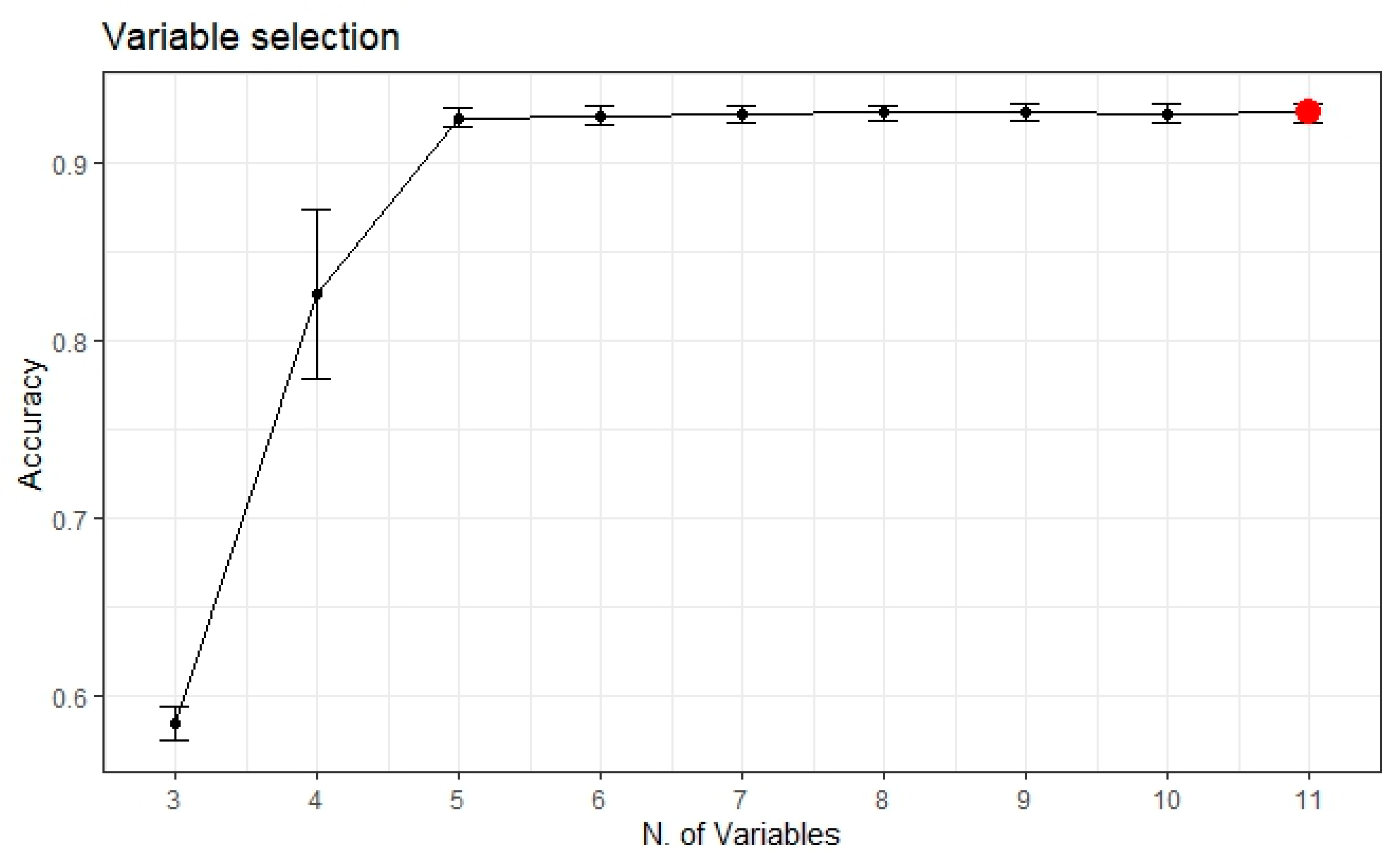
2.5. Variable Selection and Modeling
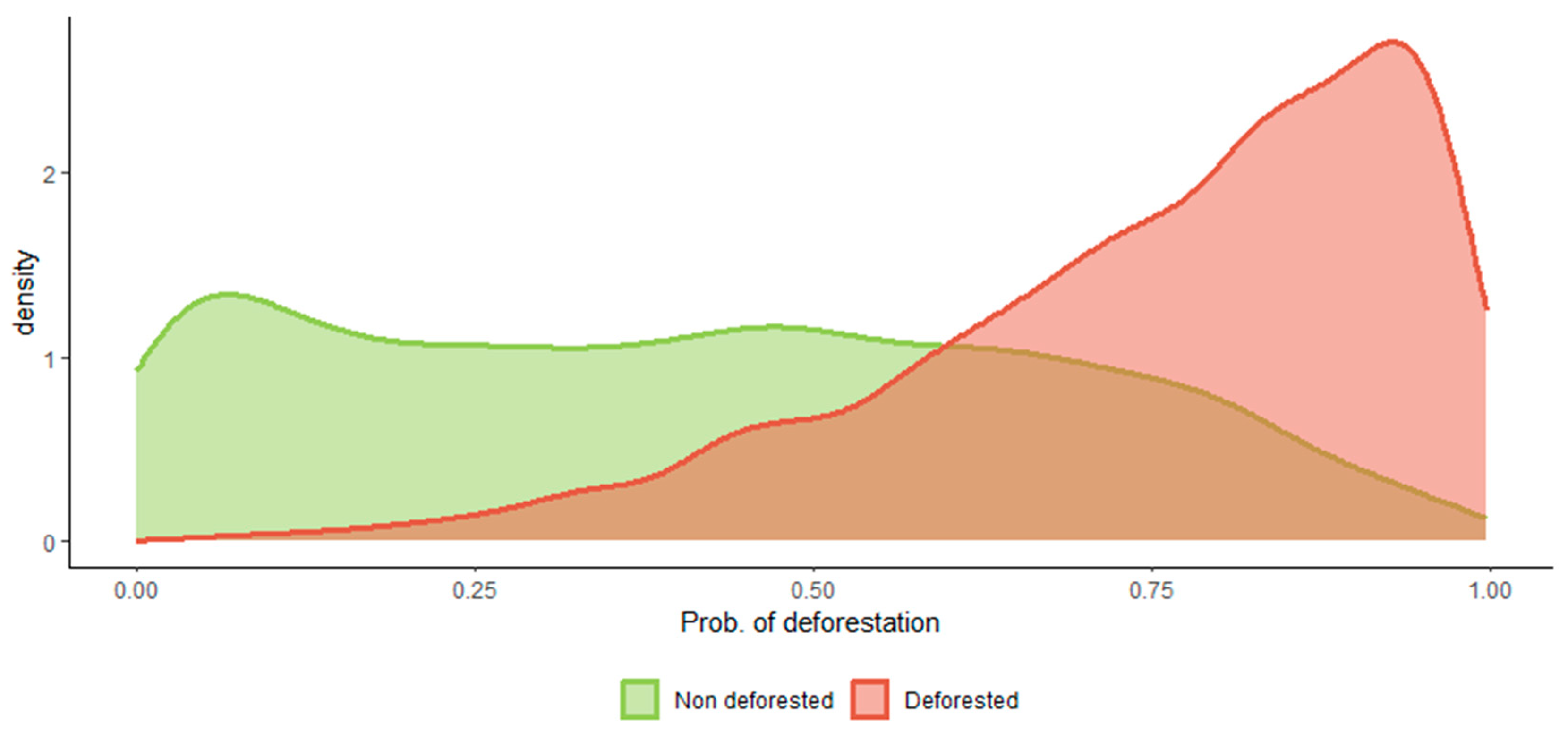
2.6. Deforestation Detection
2.7. Auxiliary Analyses
3. Results
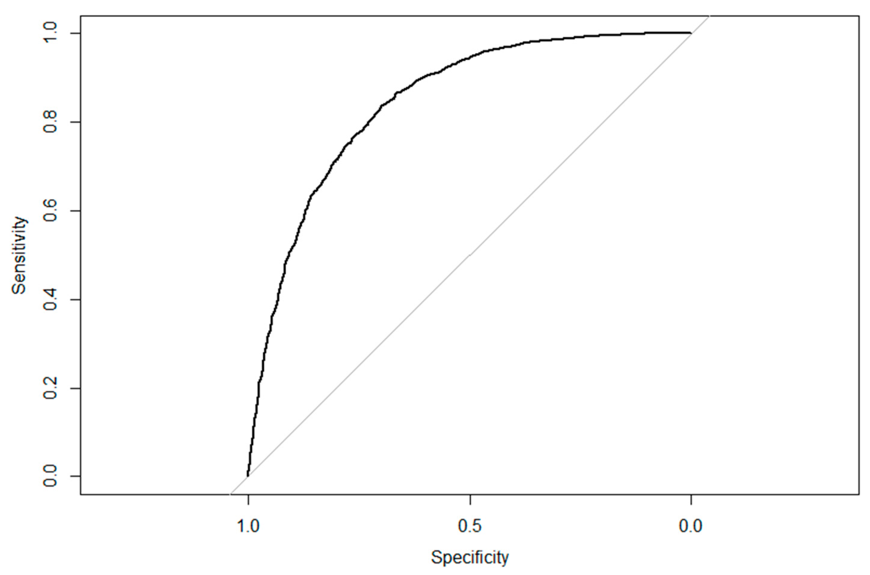
3.1. Land Cover Models Performance
3.2. Predictive Performance of the RF Models
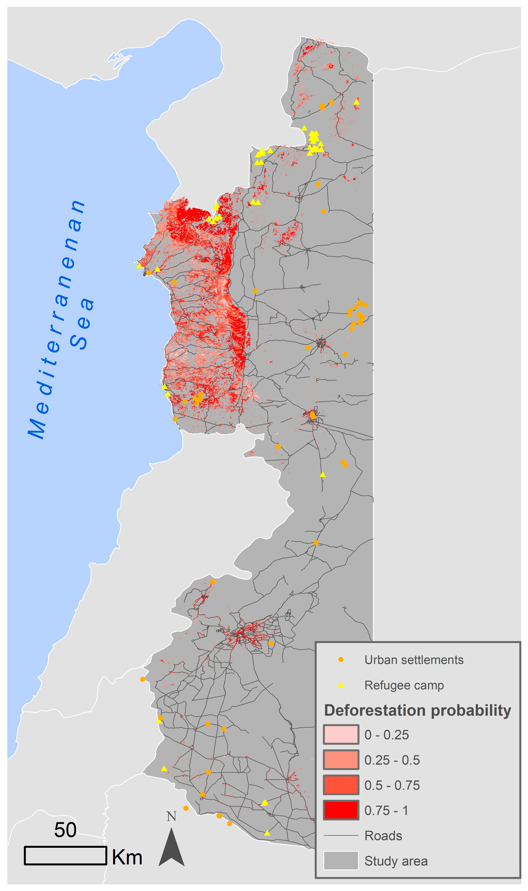
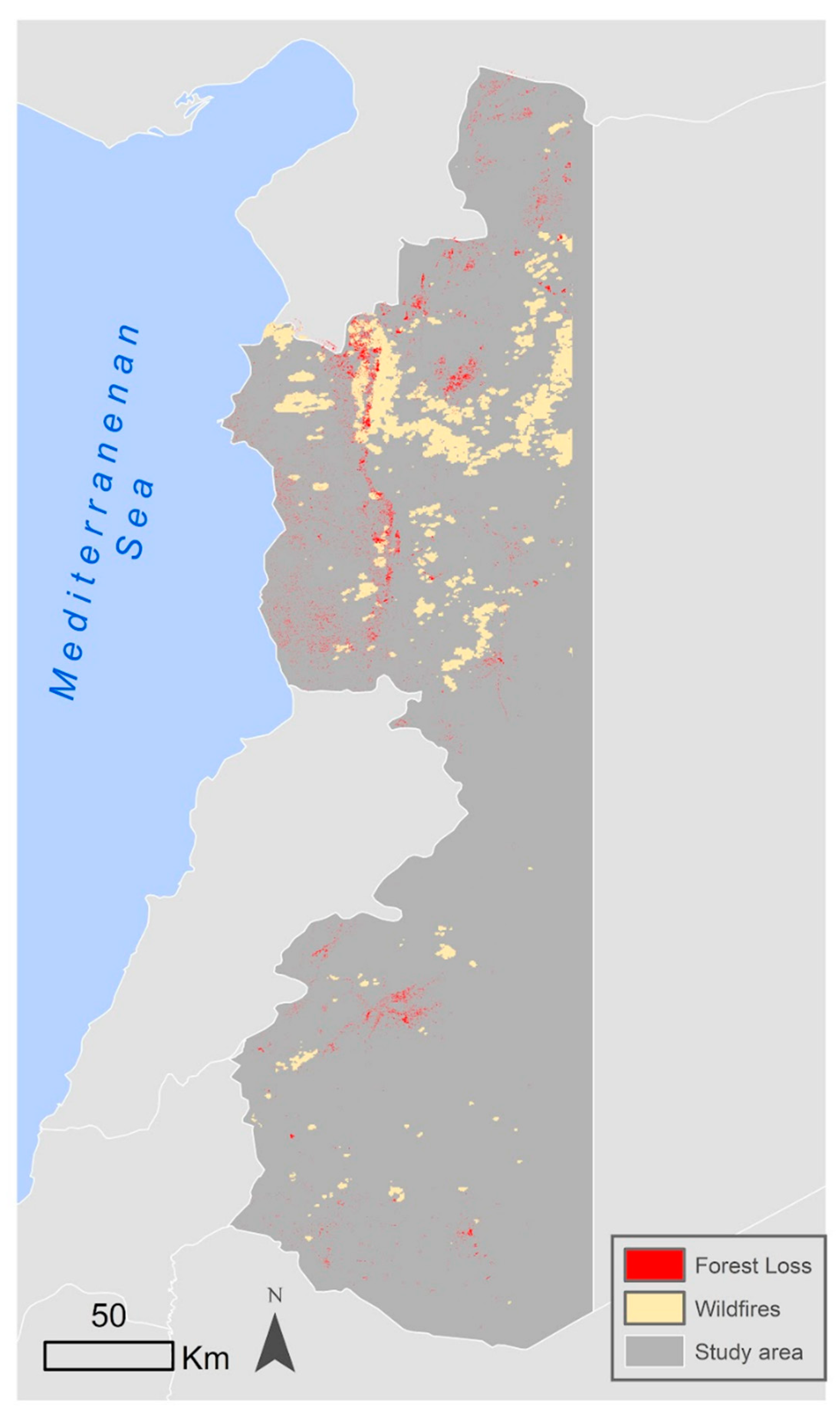
3.3. Overall Deforestation Patterns
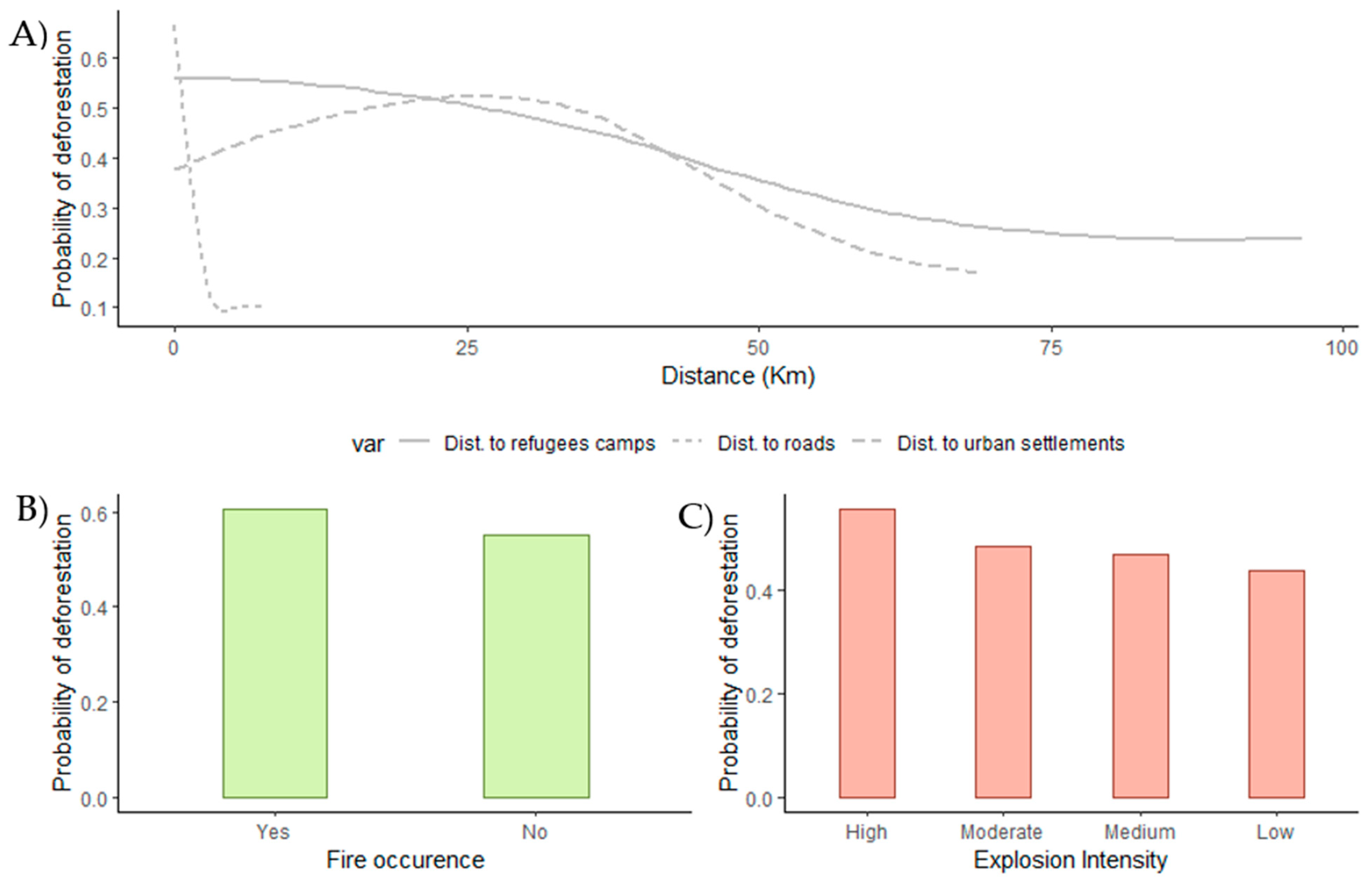
3.4. Continuous Variables: Distance to Roads, Urban Settlements, and Refugee Camps
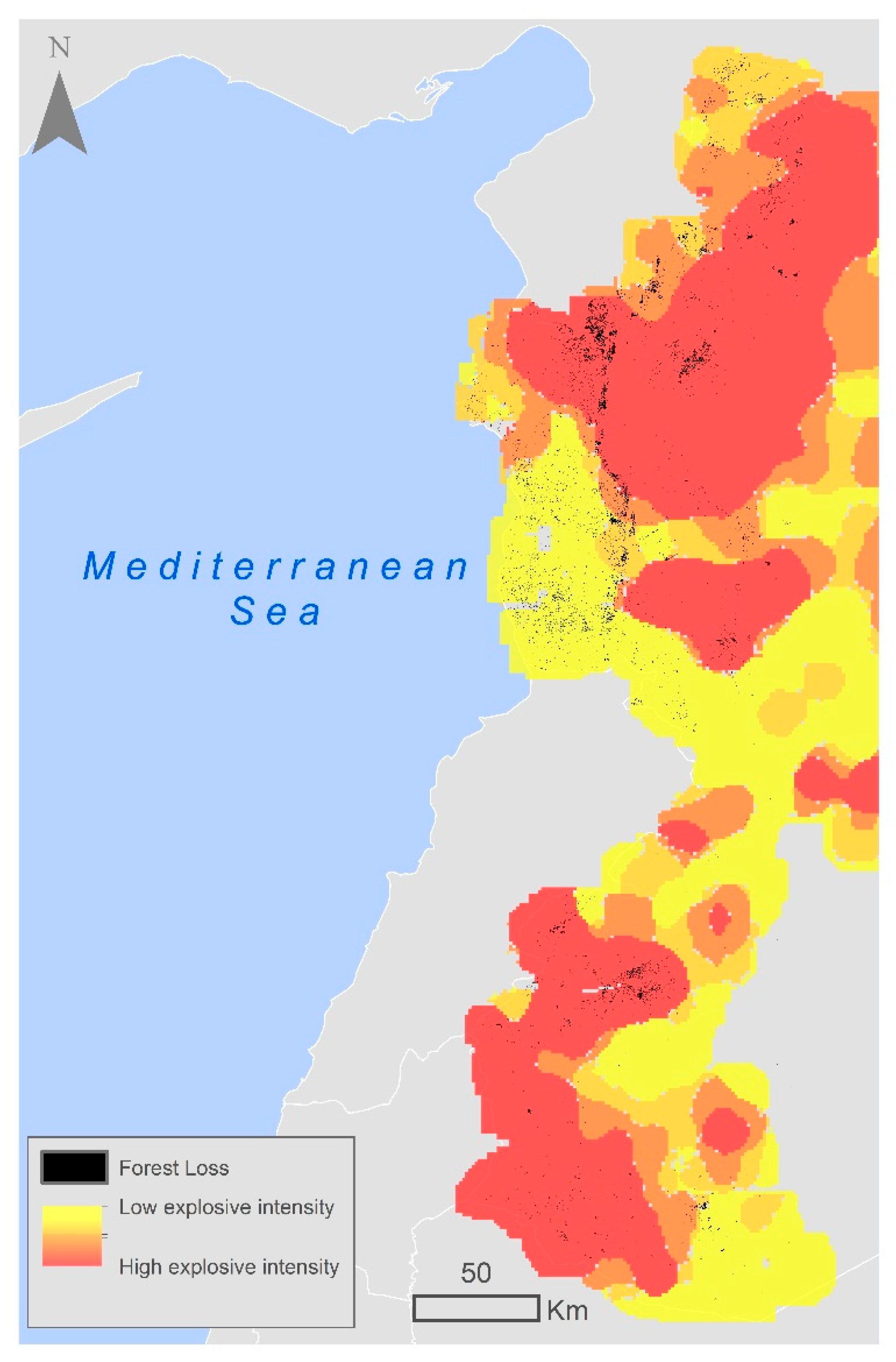
3.5. Discrete Variables: Intensity of Explosive Events
4. Discussion
5. Conclusions
Author Contributions
Funding
Data Availability Statement
Conflicts of Interest
Appendix A

| Train | Test | |
|---|---|---|
| Forest | 1800 | 1200 |
| Non-Forest | 1800 | 1200 |
| Reference | ||
|---|---|---|
| Prediction | Forest | Non-forest |
| Forest | 1157 | 158 |
| Non-forest | 43 | 1042 |
| Ov. Acc.: 91% | Kappa: 0.83 | |
| Variable | Average Influence | SD Influence |
|---|---|---|
| TCW | 96.04 | 3.34 |
| HV_corr | 45.83 | 2.77 |
| HH_corr | 43.88 | 2.22 |
| HH_var | 36.47 | 2.26 |
| HV_savg | 34.65 | 1.45 |
| HH_savg | 22.16 | 1.46 |
| HV | 21.21 | 1.46 |
| HH | 20.90 | 2.33 |
| HV_var | 19.87 | 1.09 |
| HV_ent | 19.58 | 0.91 |
| HH_ent | 19.46 | 1.79 |


References
- Midgley, G.F.; Thuiller, W. Potential responses of terrestrial biodiversity in Southern Africa to anthropogenic climate change. Reg. Environ. Chang. 2011, 11 (Suppl. S1), 127–135. [Google Scholar] [CrossRef]
- Naveh, Z.; Lieberman, A.S. The Evolution of Landscape Ecology. In Landscape Ecology; Springer: New York, NY, USA, 1994. [Google Scholar]
- Schaphoff, S.; Lucht, W.; Gerten, D.; Sitch, S.; Cramer, W.; Prentice, I.C. Terrestrial biosphere carbon storage under alternative climate projections. Clim. Chang. 2006, 74, 97–122. [Google Scholar] [CrossRef]
- Scholze, M.; Knorr, W.; Arnell, N.W.; Prentice, I.C. A climate-change risk analysis for world ecosystems. Proc. Natl. Acad. Sci. USA 2006, 103, 13116–13120. [Google Scholar] [CrossRef] [PubMed]
- Schulz, J.J.; Cayuela, L.; Rey-Benayas, J.M.; Schröder, B. Factors influencing vegetation cover change in Mediterranean Central Chile (1975–2008). Appl. Veg. Sci. 2011, 14, 571–582. [Google Scholar] [CrossRef]
- Hanson, T.; Brooks, T.M.; DA Fonseca, G.A.B.; Hoffmann, M.; Lamoreux, J.F.; Machlis, G.; Mittermeier, C.G.; Mittermeier, R.A.; Pilgrim, J.D. Warfare in biodiversity hotspots. Conserv. Biol. 2009, 23, 578–587. [Google Scholar] [CrossRef] [PubMed]
- Gbanie, S.; Griffin, A.; Thornton, A. Impacts on the Urban Environment: Land Cover Change Trajectories and Landscape Fragmentation in Post-War Western Area, Sierra Leone. Remote Sens. 2018, 10, 129. [Google Scholar] [CrossRef]
- Dudley, J.P.; Ginsberg, J.R.; Plumptre, A.J.; Hart, J.A.; Campos, L.C. Effects of war and civil strife on wildlife and wildlife habitats. Conserv. Biol. 2002, 16, 319–329. [Google Scholar] [CrossRef]
- Quist, M.C.; Fay, P.A.; Guy, C.S.; Knapp, A.K.; Rubenstein, B.N. Military training effects on terrestrial and aquatic communities on a grassland military installation. Ecol. Appl. 2003, 13, 432–442. [Google Scholar] [CrossRef]
- Hutchinson, J.M.S.; Jacquin, A.; Hutchinson, S.L.; Verbesselt, J. Monitoring vegetation change and dynamics on U.S. Army training lands using satellite image time series analysis. Anal. J. Environ. Manag. 2015, 150, 301–4797. [Google Scholar] [CrossRef]
- Collier, P. Breaking the Conflict Trap: Civil War and Development Policy; Wold Bank Publications: Washington, DC, USA, 2003; Volume 41181. [Google Scholar]
- McNeely, J.A. Biodiversity, War, and Tropical Forests. J. Sustain. For. 2003, 16, 1–20. [Google Scholar] [CrossRef]
- Hart, T.; Mwinyihali, R. Armed Conflict and Biodiversity in Sub-Saharan Africa: The Case of the Democratic Republic of Congo (DRC); Biodiversity Support Programme (BSP): Washington, DC, USA, 2001. [Google Scholar]
- FAO. Global Forest Resources 2005 Assessment: Progress towards Sustainable Forest Management. 2006. Available online: https://www.fao.org/publications/card/es/c/4821656d-4806-5c6f-9a7d-ec5d702c29a6/ (accessed on 7 May 2023).
- Nietschmann, B. Conservation by conflict in Nicaragua.social analysis: Rethinking Some West African Environmental Natural History. Nat. Hist. 1990, 11, 42–49. [Google Scholar]
- Hart, T.; Hart, J.; Fimbel, C.; Fimbel, R. Conservation and civilstrife: Two perspectives from Central Africa. Onservation Biol. 1997, 11, 308–310. [Google Scholar] [CrossRef]
- Plumptre, A.J. Lessons learned from on-the ground conservation in Rwanda and the Democratic Republic of the Congo. J. Sustain. For. 2003, 16, 71–92. [Google Scholar] [CrossRef]
- Ordway, E.M. Political shifts and changing forests: Effects of armed conflict on forest conservation in Rwanda. Glob. Ecol. Conserv. 2015, 3, 448–460. [Google Scholar] [CrossRef]
- Formoli, T.A. Impacts of the Afghan–Soviet War on Afghanistan’s Environment. Environ. Conserv. 1995, 22, 66–69. [Google Scholar] [CrossRef]
- Esmail, M.; Zurmati, G.Y. Request for Protection and Surveillance of Afghanistan’s Forests; Afghanistan Forest Protect Project MADERA: Peshawar, Pakistan, 1991; Volume 12. [Google Scholar]
- Mcpherson, N.; Fernando, B.K. Opportunities for Improved Environmental Management in Afghanistan: Report of a Mission under Contract to UNOCA; World Conservation Union (IUCN): Gland, Switzerland, 1991; Volume 66. [Google Scholar]
- Siddig, A.A.H. Biodiversity of Sudan: Between the harsh conditions, political instability and civil wars. Biodivers. J. 2014, 5, 545–555. [Google Scholar]
- Gaafar, A. Forest plantations and woodlots in Sudan. African For. Forum Ser. 2011, 1, 15–20. [Google Scholar]
- Ehteshami, A.; Huber, D.; Paciello, M.C. The Mediterranean Reset: Geopolitics in a New Age. In Global Policy; John Wiley: Hoboken, NJ, USA, 2017. [Google Scholar]
- MEDSEC. Environment and Security Issues in the Southern Mediterranean Region. 2009, p. 52. Available online: https://www.grida.no/resources/8337 (accessed on 7 May 2023).
- Zaimeche, S.E. The Consequences of Rapid Deforestation: A North African Example. Ambio 1994, 23, 136–140. Available online: http://www.jstor.org/stable/4314180 (accessed on 7 May 2023).
- Ministère de l’agriculture et de la réforme agraire (MAR). Statistique Agricole Volume 1 de Etudes et Enquêtes; Ministère de l’Agriculture et de la Réforme Agraire: Paris, France, 1966. [Google Scholar]
- Mitri, G.; Nader, M.; Van der Molen, I.; Lovett, J. Evaluating exposure to land degradation in association with repetitive armed conflicts in North Lebanon using multi-temporal satellite data. Environ. Monit. Assess. 2014, 186, 7655–7672. [Google Scholar] [CrossRef]
- United Nations. UN News. 2023. Available online: https://news.un.org/en/focus/syria (accessed on 20 April 2023).
- OCHA. Annual Report. 2017. Available online: https://www.unocha.org/publication/ocha-annual-report/ocha-annual-report-2017 (accessed on 3 April 2023).
- Abdo, H.G. Impacts of war in Syria on vegetation dynamics and erosion risks in Safita area, Tartous, Syria. Reg. Environ. Chang. 2018, 18, 1707–1719. [Google Scholar] [CrossRef]
- Barakat, M.; Mahfoud, I.; Kwyes, A. Study of soil erosion risk in thebasin of Northern Al-Kabeer river at Lattakia-Syria using remotesensing and GIS techniques. Mesopotamian J. Mar. Sci. 2014, 29, 29–44. [Google Scholar] [CrossRef]
- Boyd, D.S.; Danson, F.M. Satellite remote sensing of forest resources: Three decades of research development. Prog. Phys. Geogr. 2005, 29, 1–26. [Google Scholar] [CrossRef]
- Joseph, S.; Murthy, M.S.R.; Thomas, A.P. The progress on remote sensing technology in identifying tropical forest degradation: A synthesis of the present knowledge and future perspectives. Environ. Earth Sci. 2011, 64, 731–741. [Google Scholar] [CrossRef]
- Myers, N. Tropical deforestation and remote sensing. For. Ecol. Manag. 1988, 23, 215–225. [Google Scholar] [CrossRef]
- Bhattacharya, M. Machine Learning for Bioclimatic Modelling. Int. J. Adv. Comput. Sci. Appl. 2013, 4, 1–8. [Google Scholar] [CrossRef]
- Devasena, L. Comparative Analysis of Random Forest, REP Tree and J48 Classifiers for Credit Risk Prediction. Int. J. Comput. Appl. 2014, 975, 975–8887. [Google Scholar]
- Hsieh, W.W. Machine Learning Methods in the Environmental Sciences: Neural Networks and Kernels; Cambridge University Press: Cambridge, UK, 2009. [Google Scholar]
- Huang, Y.; Zhao, L. Review on landslide susceptibility mapping using support vector machines. Catena 2018, 165, 520–529. [Google Scholar] [CrossRef]
- Saha, S.; Bhattacharjee, S.; Shit, P.K.; Sengupta, N.; Bera, B. Deforestation probability assessment using integrated machine learning algorithms of Eastern Himalayan foothills (India). Resour. Conserv. Recycl. Adv. 2022, 14, 200077. [Google Scholar] [CrossRef]
- Khan, S.A.; Gulfishan, M.; Mir, R.A.; Andrabi, A.H. Forest cover change detection through modern applications and its environmental impacts, A review. Int. J. Ecol. Environ. Sci. 2022, 4, 75–82. [Google Scholar]
- Gorsevski, V.B. Impacts of Conflict on Land Use and Land Cover in the Imatong Mountain Region of South Sudan and Northern Uganda. Ph.D. Thesis, University of Maryland, College Park, MD, USA, 2012. [Google Scholar]
- Eklund, L.; Persson, A.; Pilesjö, P. Cropland changes in times of conflict, reconstruction, and economic development in Iraqi Kurdistan. Ambio 2016, 45, 78–88. [Google Scholar] [CrossRef]
- Estel, S.; Kuemmerle, T.; Alcántara, C.; Levers, C.; Prishchepov, A.; Hostert, P. Mapping farmland abandonment and recultivation across Europe using MODIS NDVI time series. Remote Sens. Environ. 2015, 163, 312–325. [Google Scholar] [CrossRef]
- Estel, S.; Kuemmerle, T.; Levers, C.; Baumann, M.; Hostert, P. Mapping cropland-use intensity across Europe using MODIS NDVI time series. Environ. Res. Lett. 2016, 11, 024015. [Google Scholar] [CrossRef]
- Alcantara, C.; Kuemmerle, T.; Baumann, M.; Bragina, E.V.; Griffiths, P.; Hostert, P.; Knorn, J.; Müller, D.; Prishchepov, A.V.; Schierhorn, F.; et al. Mapping the extent of abandoned farmland in Central and Eastern Europe using MODIS time series satellite data. Environ. Res. Lett. 2013, 8, 035035. [Google Scholar] [CrossRef]
- Ghazal, A. Landscape Ecological, Phytosociological and Geobotanical Study of Eu-Mediterranean in West of Syria; University of Hohenheim, Faculty of Agricultural Sciences: Stuttgart, Germany, 2008. [Google Scholar]
- Forestry Statistics. Syrian National Forestry Statistics; The Syrian Ministry of Agriculture: Damascus, Syria, 2005.
- Nahal, I. The Mediterranean climate from a biological viewpoint. In Mediterranean-Type Shrublands of the World; di Castri, F., Goodall, D.W., Specht, R.L., Eds.; Elsevier: Amsterdam, The Netherlands, 1981. [Google Scholar]
- Gorelick, N.; Hancher, M.; Dixon, M.; Ilyushchenko, S.; Thau, D.; Moore, R. Google Earth Engine: Planetary-scale geospatial analysis for everyone. Remote Sens. Environ. 2017, 202, 18–27. [Google Scholar] [CrossRef]
- Kennedy, R.E.; Yang, Z.; Cohen, W.B. Detecting trends in forest disturbance and recovery using yearly Landsat time series: 1. LandTrendr—Temporal segmentation algorithms. Remote Sens. Environ. 2010, 114, 2897–2910. [Google Scholar] [CrossRef]
- Gelabert, P.J.; Rodrigues, M.; de la Riva, J.; Ameztegui, A.; Sebastià, M.T.; Vega-Garcia, C. LandTrendr smoothed spectral profiles enhance woody encroachment monitoring. Remote Sens. Environ. 2021, 262, 112521. [Google Scholar] [CrossRef]
- Kennedy, R.E.; Yang, Z.; Gorelick, N.; Braaten, J.; Cavalcante, L.; Cohen, W.B.; Healey, S. Implementation of the LandTrendr algorithm on Google Earth Engine. Remote Sens. 2018, 10, 691. [Google Scholar] [CrossRef]
- Crist, E.P.; Cicone, R.C. A Physically-Based Transformation of Thematic Mapper Data—The TM Tasseled Cap. IEEE Trans. Geosci. Remote Sens. 1984, GE-22, 256–263. [Google Scholar] [CrossRef]
- Matasci, G.; Hermosilla, T.; Wulder, M.A.; White, J.C.; Coops, N.C.; Hobart, G.W.; Bolton, D.K.; Tompalski, P.; Bater, C.W. Three decades of forest structural dynamics over Canada’s forested ecosystems using Landsat time-series and lidar plots. Remote Sens. Environ. 2018, 216, 697–714. [Google Scholar] [CrossRef]
- Crist, E.P. A TM Tasseled Cap equivalent transformation for reflectance factor data. Remote Sens. Environ. 1985, 17, 301–306. [Google Scholar] [CrossRef]
- Roy, D.P.; Kovalskyy, V.; Zhang, H.K.; Vermote, E.F.; Yan, L.; Kumar, S.S.; Egorov, A. Characterization of Landsat-7 to Landsat-8 reflective wavelength and normalized difference vegetation index continuity. Remote Sens. Environ. 2016, 185, 57–70. [Google Scholar] [CrossRef] [PubMed]
- Shimada, M.; Itoh, T.; Motooka, T.; Watanabe, M.; Shiraishi, T.; Thapa, R.; Lucas, R. New global forest/non-forest maps from ALOS PALSAR data (2007–2010). Remote Sens. Environ. 2014, 155, 13–31. [Google Scholar] [CrossRef]
- Sen Lee, J. Refined filtering of image noise using local statistics. Comput. Graph. Image Process. 1981, 15, 380–389. [Google Scholar] [CrossRef]
- Haralick, R.M.; Shanmugam, K.; Dinstein, I.H. Textural Features for Image Classification. IEEE Trans. Syst. Man Cybern. 1973, 165, 520–529. [Google Scholar] [CrossRef]
- Potapov, P.; Li, X.; Hernandez-Serna, A.; Tyukavina, A.; Hansen, M.C.; Kommareddy, A.; Pickens, A.; Turubanova, S.; Tang, H.; Silva, C.E.; et al. Mapping global forest canopy height through integration of GEDI and Landsat data. Remote Sens. Environ. 2021, 253, 112165. [Google Scholar] [CrossRef]
- Breiman, L. Random forests. Mach. Learn. 2001, 45, 5. [Google Scholar] [CrossRef]
- Cortes, C.; Vapnik, V. Support-Vector Networks. Mach. Learn. 1995, 20, 273–297. [Google Scholar] [CrossRef]
- Vapnik, V. The Nature of Statistical Learning Theory; Springer: New York, NY, USA, 1995. [Google Scholar] [CrossRef]
- Kavzoglu, T.; Colkesen, I. A kernel functions analysis for support vector machines for land cover classification. Int. J. Appl. Earth Obs. Geoinf. 2009, 11, 352–359. [Google Scholar] [CrossRef]
- Noi, P.T.; Kappas, M. Comparison of random forest, k-nearest neighbor, and support vector. Sensors 2017, 18, 18. [Google Scholar]
- Kuhn, M. Building predictive models in R using the caret package. J. Stat. Softw. 2008, 28, 1–26. [Google Scholar] [CrossRef]
- Hijmans, R.J. Raster: Geographic Data Analysis and Modeling. 2019. Available online: https://cran.r-project.org/web/packages/raster/index.html (accessed on 13 October 2022).
- McHugh, M.L. Interrater reliability: The kappa statistic. Biochem. Medica 2012, 22, 276–282. [Google Scholar] [CrossRef]
- OpenStreetMap Contributors. Planet Dump. 2023. Available online: https://planet.osm.org (accessed on 13 October 2022).
- U.S. Department of State Humanitarian Information Unit. Syria IDP Sites. Available online: https://data.humdata.org/dataset/syria-idp-sites (accessed on 13 October 2022).
- Giglio, L.; Boschetti, L.; Roy, D.P.; Humber, M.L.; Justice, C.O. The Collection 6 MODIS. Remote Sens. Environ. 2018, 217, 72–85. [Google Scholar] [CrossRef]
- UNOCHA. Syrian Arab Republic—Humanitarian Needs Overview; UNOCHA: New York, NY, USA, 2021; p. 53. [Google Scholar]
- Cheng, Y.; Yu, L.; Cracknell, A.P.; Gong, P. Oil palm mapping using Landsat and PALSAR: A case study in Malaysia. Int. J. Remote Sens. 2016, 37, 5431–5442. [Google Scholar] [CrossRef]
- Martini, G. Forest Sector Policy and Institutional Development; Forest Institutions in Syrian Forestry Sector: Latakia, Syria, 2009. [Google Scholar]
- FAO. Global Forest Resources Assessment 2015: Country Report—Syrian Arab Republic; FAO: Rome, Italy, 2014; Available online: https://www.fao.org/documents/card/en?details=c700748b-7581-4394-a946-3d9e7540f2db%2F (accessed on 12 November 2022).
- SANA. Ministry of Agriculture: The Production of Forest Seedlings Is Gradually Regaining Its Size, and Most of the Forest FIRES Were Intentional; Syrian Arab News Agency: Damascus, Syria, 2020; Available online: https://sana.sy/?p=1124278 (accessed on 5 June 2023).
- ReliefWeb. Syria: Unprecedented Rise in Poverty Rate, Significant Shortfall in Humanitarian Aid Funding. 2022. Available online: https://reliefweb.int/report/syrian-arab-republic/syria-unprecedented-rise-poverty-rate-significant-shortfall-humanitarian-aid-funding-enar (accessed on 5 June 2023).
- Raseef22. Random Loggers Turn Syria’s Oak Tree Forests to Charcoal. 2022. Available online: https://raseef22.net/english/article/1090178-random-loggers-turn-syrias-oak-tree-forests-to-charcoal (accessed on 5 April 2023).
- Mohamed, M.A. An assessment of forest cover change and its driving forces in the syrian coastal region during a period of conflict, 2010 to 2020. Land 2021, 10, 191. [Google Scholar] [CrossRef]
- Bouriaud, L. Causes of illegal logging in Central and Eastern Europe. Small-Scale For. Econ. Manag. Policy 2005, 4, 269–291. [Google Scholar] [CrossRef]
- Cunningham, A.B.; Tientcheu, M.L.A.; Anoncho, V.F.; Nkuinkeu, R.; Sunderland, T. Power, profits and policy: A reality check on the Prunus africana bark trade. CIFOR Work. Pap. 2014, 153, 17. [Google Scholar]
- van den Top, G.M. The Social Dynamics of Deforestation in the Sierra Madre, Philippines; Leiden University: Leiden, The Netherlands, 1998. [Google Scholar]
- van der Ploeg, J.; Araño, R.R.; Van Weerd, M. What local people think about crocodiles: Challenging environmental policy narratives in the Philippines. J. Environ. Dev. 2011, 20, 303–328. [Google Scholar] [CrossRef]
- Barber, C.P.; Cochrane, M.A.; Souza, C.M.; Laurance, W.F. Roads, deforestation, and the mitigating effect of protected areas in the Amazon. Biol. Conserv. 2014, 177, 203–209. [Google Scholar] [CrossRef]
- De Luca, G. Roads, Development and Deforestation: A review. At Loggerheads? Agricultural Expansion, Poverty Reduction, and Environment in the Tropical Forests. 2006, p. 308. Available online: https://elibrary.worldbank.org/doi/abs/10.1596/978-0-8213-6735-3 (accessed on 12 November 2022).
- Salemi, C. Refugee camps and deforestation in Sub-Saharan Africa. J. Dev. Econ. 2021, 152, 102682. [Google Scholar] [CrossRef]
- Ahmed, N.; Islam, M.N.; Hasan, M.F.; Motahar, T.; Sujauddin, M. Understanding the political ecology of forced migration and deforestation through a multi-algorithm classification approach: The case of Rohingya displacement in the southeastern border region of Bangladesh. Geol. Ecol. Landsc. 2019, 3, 282–294. [Google Scholar] [CrossRef]
- Syria Untold. War on the Forests of the Syrian Coast. 2019. Available online: https://syriauntold.com/2019/06/06/war-on-the-forests-of-the-syrian-coast/ (accessed on 15 April 2023).
- Christou, W. Looting, Burning, Cutting: How a Decade of War Has Shrunk Syria’s Forests. Syria Direct. 2020. Available online: https://syriadirect.org/looting-burning-cutting-how-a-decade-of-war-has-shrunk-syrias-forests/ (accessed on 20 April 2023).
- ReliefWeb. Explosive Ordnance in Syria: Impact and Required Action. 2022. Available online: https://reliefweb.int/report/syrian-arab-republic/explosive-ordnance-syria-impact-and-required-action-report-may-2022 (accessed on 10 January 2023).
- Ministry of Ecology and Natural Resources of Ukraine (MENR). Regulation on the Project for Planning the Territory of the National Nature Park, Conservation, Restoration and Recreational Use of Its Natural Systems and Sites; Decree of MENR No. 273 of 21.08.2014; MENR: Kyiv, Ukraine, 2014. [Google Scholar]
- Heiderscheidt, J.A. The Impact of World War One on the Forests and Soils of Europe. Ursidae Undergrad. Res. J. Univ. North. Color. 2018, 7, 3. Available online: https://digscholarship.unco.edu/urjAvailableat:https://digscholarship.unco.edu/urj/vol7/iss3/3 (accessed on 12 November 2022).
- Hanson, T. Biodiversity conservation and armed conflict: A warfare ecology perspective. Ann. N. Y. Acad. Sci. 2018, 1429, 50–65. [Google Scholar] [CrossRef] [PubMed]
- Almohamad, H. Impact of land cover change due to armed conflicts on soil erosion in the basin of the northern al-kabeer river in syria using the rusle model. Water 2020, 12, 3323. [Google Scholar] [CrossRef]
- Kassioun. Wildfires in Syria: What Is the Accurate Number and What Is the Actual Cause? 2020. Available online: https://kassioun.org/en/articles/item/65965-wildfires-in-syria-what-is-the-accurate-number-and-what-is-the-actual-cause (accessed on 20 April 2023).


| Year | Accumulated Loss (%) | Remaining Forest Area (ha) | Lost Forested Area (ha) |
|---|---|---|---|
| 2010 | 0 | 337,500 | 0 |
| 2015 | 11.5 | 298,687.5 | 38,812.5 |
| 2016 | 13.4 | 292,275 | 45,225 |
| 2017 | 14.3 | 289,237.5 | 48,262.5 |
| 2018 | 15.2 | 286,200 | 51,300 |
| 2019 | 19.3 | 272,362.5 | 65,137.5 |
| Total Burned Forest Area 2010–2019 (ha) | 15,242.49 | ||
| Total Loss by Burning (%) | 23.4 |
Disclaimer/Publisher’s Note: The statements, opinions and data contained in all publications are solely those of the individual author(s) and contributor(s) and not of MDPI and/or the editor(s). MDPI and/or the editor(s) disclaim responsibility for any injury to people or property resulting from any ideas, methods, instructions or products referred to in the content. |
© 2023 by the authors. Licensee MDPI, Basel, Switzerland. This article is an open access article distributed under the terms and conditions of the Creative Commons Attribution (CC BY) license (https://creativecommons.org/licenses/by/4.0/).
Share and Cite
Daiyoub, A.; Gelabert, P.; Saura-Mas, S.; Vega-Garcia, C. War and Deforestation: Using Remote Sensing and Machine Learning to Identify the War-Induced Deforestation in Syria 2010–2019. Land 2023, 12, 1509. https://doi.org/10.3390/land12081509
Daiyoub A, Gelabert P, Saura-Mas S, Vega-Garcia C. War and Deforestation: Using Remote Sensing and Machine Learning to Identify the War-Induced Deforestation in Syria 2010–2019. Land. 2023; 12(8):1509. https://doi.org/10.3390/land12081509
Chicago/Turabian StyleDaiyoub, Angham, Pere Gelabert, Sandra Saura-Mas, and Cristina Vega-Garcia. 2023. "War and Deforestation: Using Remote Sensing and Machine Learning to Identify the War-Induced Deforestation in Syria 2010–2019" Land 12, no. 8: 1509. https://doi.org/10.3390/land12081509
APA StyleDaiyoub, A., Gelabert, P., Saura-Mas, S., & Vega-Garcia, C. (2023). War and Deforestation: Using Remote Sensing and Machine Learning to Identify the War-Induced Deforestation in Syria 2010–2019. Land, 12(8), 1509. https://doi.org/10.3390/land12081509