2. Methodology of the Inform@Risk LEWS
In the following section, we give a short outline of the methodology of our LEWS, regarding hazard and risk assessment, monitoring, community integration, and socio-spatial integration.
2.1. Hazard- and Risk Assessment
Before installing any measurement system, a detailed hazard and risk analysis has to be carried out [
35]. The goal of a risk assessment is a risk map, which combines the landslide hazard, including events with different processes and sizes, with the local vulnerability and elements at risk. To assess the hazard, a detailed investigation, including on-site geological, geomorphological and process mapping, as well as direct and indirect geological studies, such as drillings, geophysical methods, and numerical modeling, should be performed. Which of these methods are applied in a specific scenario needs to be decided after a preliminary (preferably on-site) analysis [
41].
For assessing the hazard from geological findings, we decided to use an approach that combines the locally used hazard analysis defined in the POT 2014 (Plan de Ordenamiento Territorial de Medellin [
49]) with Swiss methods for analyzing and assessing natural hazards. The latter are based on detailed geological investigation and delineation of hazard scenarios for different processes and return periods [
50]. This was subsequently blended with maps of the elements at risk; especially a detailed map of population density and a building usage classification (e.g., residential, commercial, and public buildings, such as as schools, meeting places, etc.) to arrive at a semi-quantitative risk map [
51]. Due to the low quality of most buildings, their vulnerability was not differentiated throughout the area [
40].
2.2. Combination of Measurement Systems for a Low-Cost System: CSM and Inform@Risk Geosensor Network
A measurement system was designed based on the requirements of the project (
Section 1.3). The system has been described in detail before [
42,
48].
The monitoring system is based on deformation measurement lines and a newly developed low-cost wireless geosensor network. While the former allows detecting and locating shear and extensional deformation along measurement lines up to about 300 m in length, the latter provides punctual deformation (e.g., based on an inclination sensor or jointmeter) and other measurements relevant to landslide monitoring; e.g., the triggering factors of ground water level and rainfall. A schematic layout of such a system can be seen in
Figure 1 in Gamperl et al. [
48].
The deformation measurement lines consist of a combination of CSM (continuous shear monitor, Thuro et al. [
52]) and a series of wire extensometers. These were installed horizontally into trenches, which followed streets and pathways across the slope or vertically into geological exploration drillings. If an event occurs and the lateral or basal rupture surface of the landslide passes through one of the measurement lines, the failure location and amount of shear and extensional deformation can be assessed. Ideally, if the sensor lines run across and through (in depth, in boreholes) the landslide, an accurate depiction of the size, depth, and activity of the landslide can be derived.
The newly developed open source geosensor network utilizes IoT (Internet of Things) technologies, e.g., LoRa
® (Long Range) data communication and micro-electromechanical-system (MEMS) sensors to provide a flexible versatile platform for additional relevant measurements of the surface and shallow subsurface. The wireless measurement nodes act as dataloggers with an integrated inclination, barometric pressure, and temperature sensor, and have been designed so that they can be attached directly to walls or other infrastructure and monitor their tilting [
48]. The measurement node can also be installed on top of a shallow subsurface probe, in which, depending on the ground conditions, groundwater level and inclination measurements can be performed to a depth of up to 5 m below the surface. These sensors are versatile and relatively cheap, so that, in high hazard areas, a higher quantity can be installed, making the detection of initial movements more likely.
All data were retrieved by multiple, and—in the case of the wireless geosensor network—redundant, central stations and were transmitted to an offsite data server. As the LoRa® data transmission provides ranges up to 15 km, depending on the topography, often only a few central stations are needed to cover large areas.
2.3. Community Integration into All Parts of the LEWS
In integrated LEWSs, the local at-risk community is one of the main actors [
31,
53]. This is also the case in the Inform@Risk LEWS. For this reason, multiple participatory activities needed to be developed, to address the components of risk knowledge and analysis, monitoring and forecasting, alert dissemination, and response capacity. These activities included workshops with the community regarding all four components and excursions (walking tours) with technical professionals and community members. In addition, including the community in hands-on activities, such as mapping and installation of measurement systems, can be a way of raising awareness and creating a connection to the system [
40].
2.4. Socio-Spatial Integration of a LEWS
Commonly, the mechanical-electronical parts of a LEWS are located in remote areas that are not accessible for people at risk. In the case of an informal settlement such as Bello Oriente, where people live in high-hazard areas for landslides, the sensors are located inside the neighborhood’s public space, near to and on peoples’ houses. A key factor for a successfully integrated LEWS is the acceptance and support of the residents at risk [
31,
54]. At the same time, it is necessary to protect the monitoring system from external influences. Therefore, an approach for how to spatially and socially integrate the monitoring system into the public open space and how to protect the mechanical-electronical parts was conceived.
Sensor protectors, built as benches and seats for daily use, can function as a natural reminder of the landslide risk. In combination with informative elements, such as short inscriptions and explanatory signs, these small meeting spaces seek to increase acceptance and decrease vandalism. The type and material of the public space elements should be site-specific and jointly developed with the residents at risk and experts, including, e.g., landscape architects, urban planners, and architects.
3. Installation and First Results of the System in Medellín
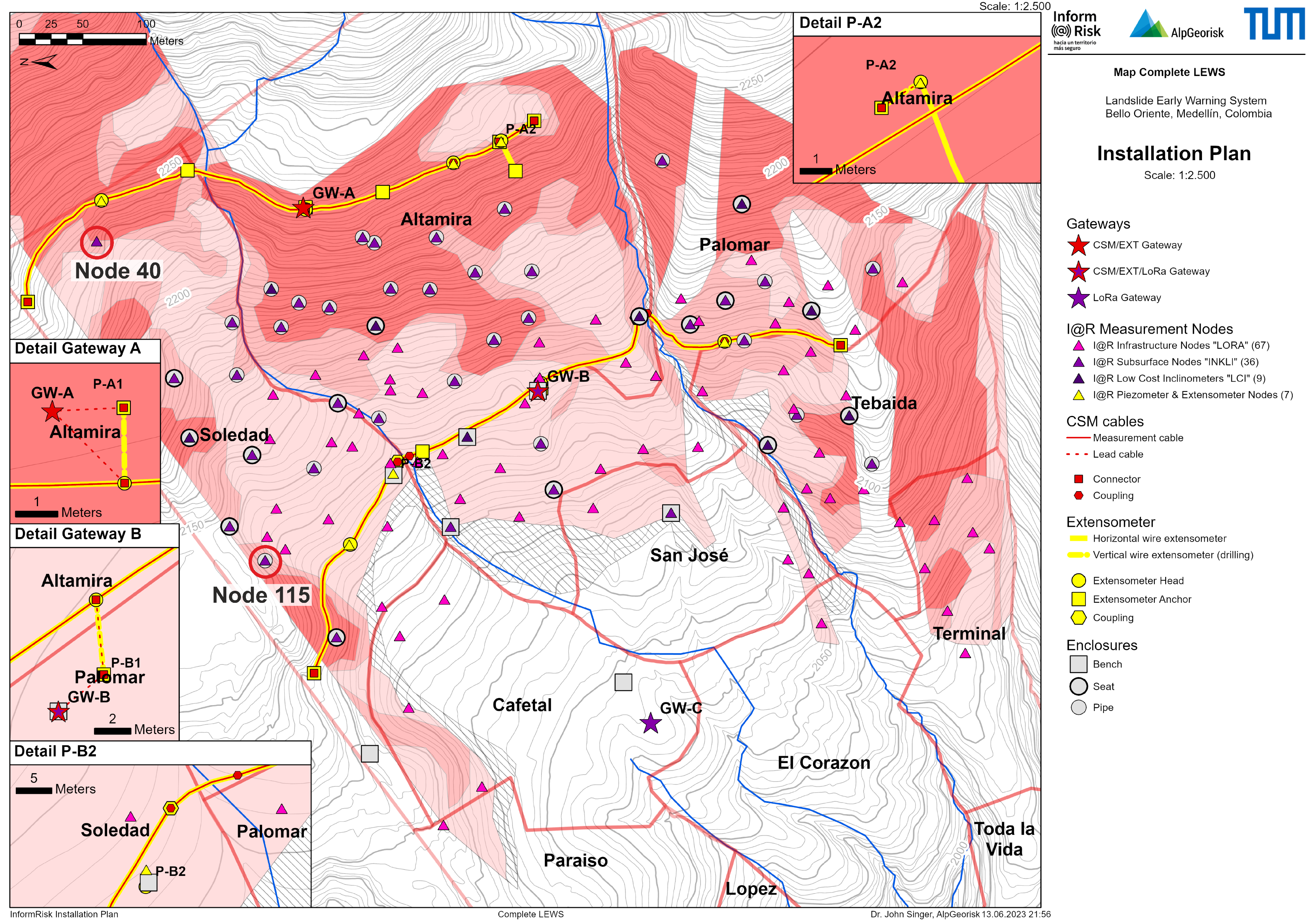
3.1. Planning of the Sensor Map Based on Risk Assessment
The risk assessment resulted in three maps with 30-, 100-, and 300-year return frequencies (see [
40]). The results were used to plan the sensor density and locations, as well as the evacuation routes, including safe meeting points. In areas with high risk, a higher density of sensors was planned, while in areas with lower risk, the density was reduced significantly. This resulted in a preliminary sensor map for the area, which was then checked and optimized with photographic analyses and on-site visits, taking, e.g., the infrastructure (sensors should only be installed on stable infrastructure, where deformation reflects ground movements, and should be installed in places with good sunlight reception for the solar panel) and the social conditions (house inhabited or not and prospects of future constructions nearby that might affect the sensor) into account (
Figure 2). The inhabitants of houses in question were asked if they agreed to have a sensor on their house. For subsurface sensors, which are located mostly in remote locations, the plot owners or the inhabitants were asked. The overall acceptance of both subsurface and infrastructure sensors was very high, and only a small number of sensors had to be moved to a different location, either because a land owner did not give permission or new construction works were carried out on the house or surroundings that affected the exposure of the solar panel of the sensor. For the gateways and large benches, the municipal planning department was involved in the site selection, so that the project would not interfere in future development plans for the neighborhood.
Figure 2.
Final installation plan for the monitoring system in Bello Oriente. Overall, 111 measurement nodes, over 1 km of horizontal measurement lines, and three gateways were installed on site. Locations of nodes 40 and 115, displayed in
Figure 3, are indicated by the red circles.
Figure 2.
Final installation plan for the monitoring system in Bello Oriente. Overall, 111 measurement nodes, over 1 km of horizontal measurement lines, and three gateways were installed on site. Locations of nodes 40 and 115, displayed in
Figure 3, are indicated by the red circles.
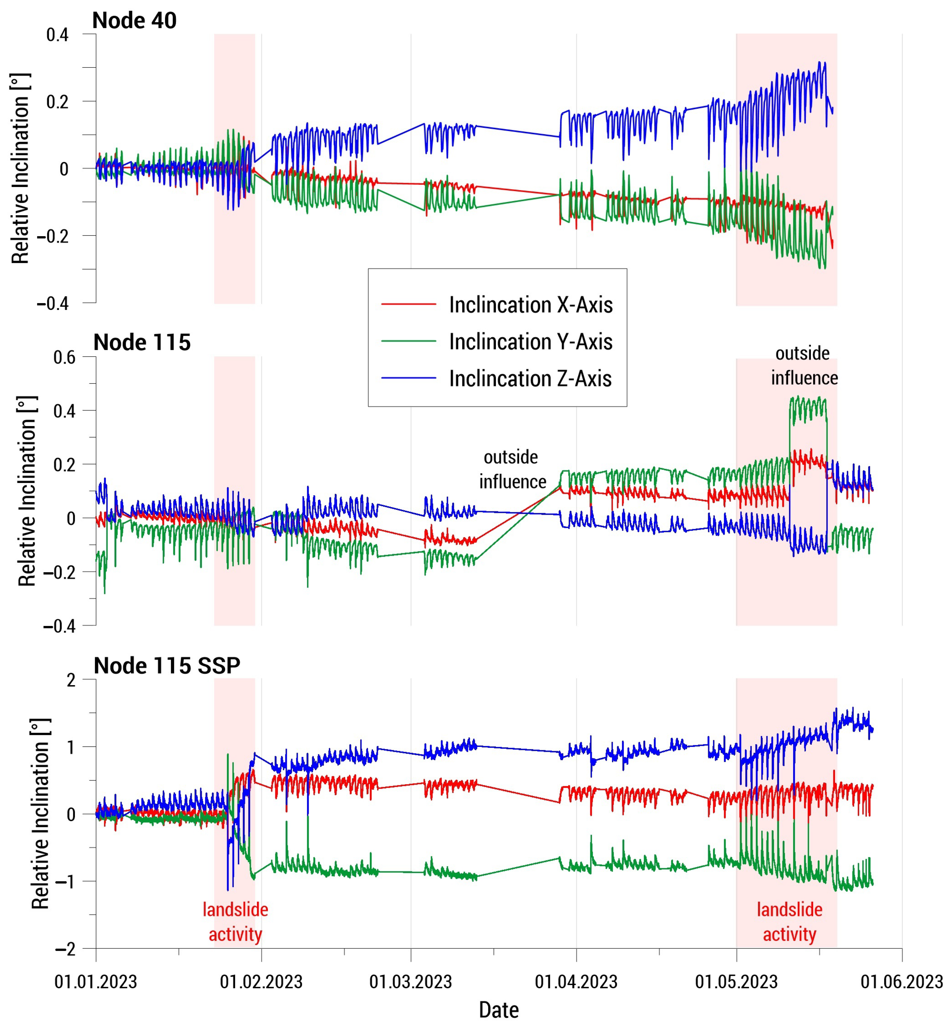
Figure 3.
Change in inclination of an infrastructure node (node 40, surface inclinometer only,
top) and a subsurface node (node 115) equipped with a surface inclinometer (
middle) and a subsurface inclinometer (SSP,
bottom) at 1.5 m depth from 1 January to 17 May 2023. See
Figure 2 for the sensor locations. (X-axis: downhill).
3.2. Installation of the Sensor System and First Sensor Data
The sensor system was developed in several steps, both in the laboratory and in the field. In these iterations, both the capabilities of the system and the ease of use and replicability were improved. Following the sensor system development and a test installation in southern Germany [
48], the installation at the test site in Colombia was implemented in the period between March and August 2022. During the installation, the sensors and the process of installation were further improved, due to onsite experiences.
In total, 111 measurement nodes, over 1 km of horizontal measurement lines, and three gateways were installed at the test site Bello Oriente in Medellin, Colombia.
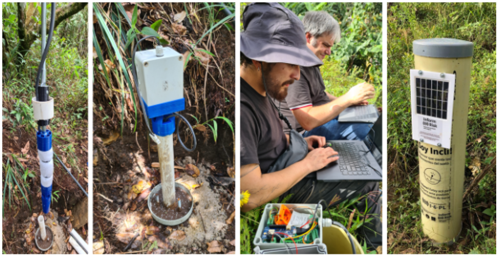
Figure 2 shows the final installation plan with the point and line measurements and the gateways. Additionally, four boreholes of 30 to 50 m depth, which were drilled for the geological investigations, were instrumented with piezometers, extensometers, and a CSM system. Some pictures of the sensors in the field are shown in
Figure 4.
For the installation, a local construction company was hired to perform the earthwork and installation of the horizontal cable lines. The company was asked to hire workers from the local community, in order to strengthen the ties between the LEWS and the community and also to help the locals economically. The installation of the point sensors was performed by researchers and students with the help of the locals. This process took 20 to 45 min for an infrastructure sensor (excluding social work) and two to four hours for a subsurface sensor (usually with no social work involved, because of a remote location).
Since the gateways were installed (August 2022), sensor data have been collected from the system. All data acquired in the geosensor network and the other measurement systems currently installed in Bello Oriente are immediately transferred to an off-site central server, where they are processed and analyzed in near real time. Then the data are stored, analyzed, and visualized using the AlpGeorisk ONLINE data management service developed and operated by AlpGeorisk. The data stored and visualized on this web platform can also be accessed utilizing an open-source smartphone app, which was developed as part of the project by the Deggendorf Institute of Technology (see Werthmann et al. [
40]).
So far, around 50,000 datapoints have been collected per day from the Inform@Risk sensor nodes. The CSM system, on the other hand, which is 1 km long and creates a datapoint for every 2 mm of cable (spatial resolution) and produces 0.5 million datapoints per measurement cycle (usually every 30 min). All data are processed to identify failed sensors and exclude false data (empty values or those outside the expected range). Most sensors were activated in the fall of 2022, so that, at the time of writing, about 1/2 year to 1 year of data exist for most sensors. Based on this data, preliminary thresholds have been set, which will be continuously refined as more measurements are made. For the inclination sensors of the Inform@Risk measurement nodes, for example, the following simple thresholds were set: notification >0.5°/month; pre-warning: 0.5°/week; warning 0.5°/day; alarm: 2°/h.
An exemplary dataset is visualized in
Figure 3. This example proves the sensitivity (<0.05°) of the MEMS inclination sensor used in the Inform@Risk measurement node. It also illustrates some of the issues the data analysis procedure has to tackle in order to produce reliable (automatic) warnings: the separation of daily, temperature-induced fluctuations from multi-day trends, the recognition of outside influences, and the interpretation of a change in inclination as an indicator of critical landslide activity.
Both nodes displayed in
Figure 3 were installed within, or in the direct vicinity of, known recently active small landslides (mid to end 2022). Each inclinometer measures in three orthogonal orientations and is capable of reliably detecting inclination changes above 0.05°. The data clearly show a daily, temperature-dependent fluctuation, which varied in magnitude depending on the type of installation and monitored object (building, retaining wall, steel pipe of subsurface probe, etc.). To date, only very small movements have been detected. However, phases of increased activity could still be identified (light red vertical bars), where all three sensors show slight trends in the data over several days. While the change in inclination in the areas marked as “landslide activity” was not high enough to trigger warning thresholds, some movement, which can be attributed to the previous landslides, was observed and the active phases correlate to periods of comparably high rainfall. Sudden changes in the inclination of a single node, especially if installed at the surface, can be attributed to outside influences.
3.3. Integration of the Community into All Parts of the LEWS in Bello Oriente
To address the community integration of the LEWS, the methods described in
Section 2.3 were deployed. In total, over 40 workshops, together with other participatory activities, with over 1000 participants were held in Bello Oriente (see also Werthmann et al. [
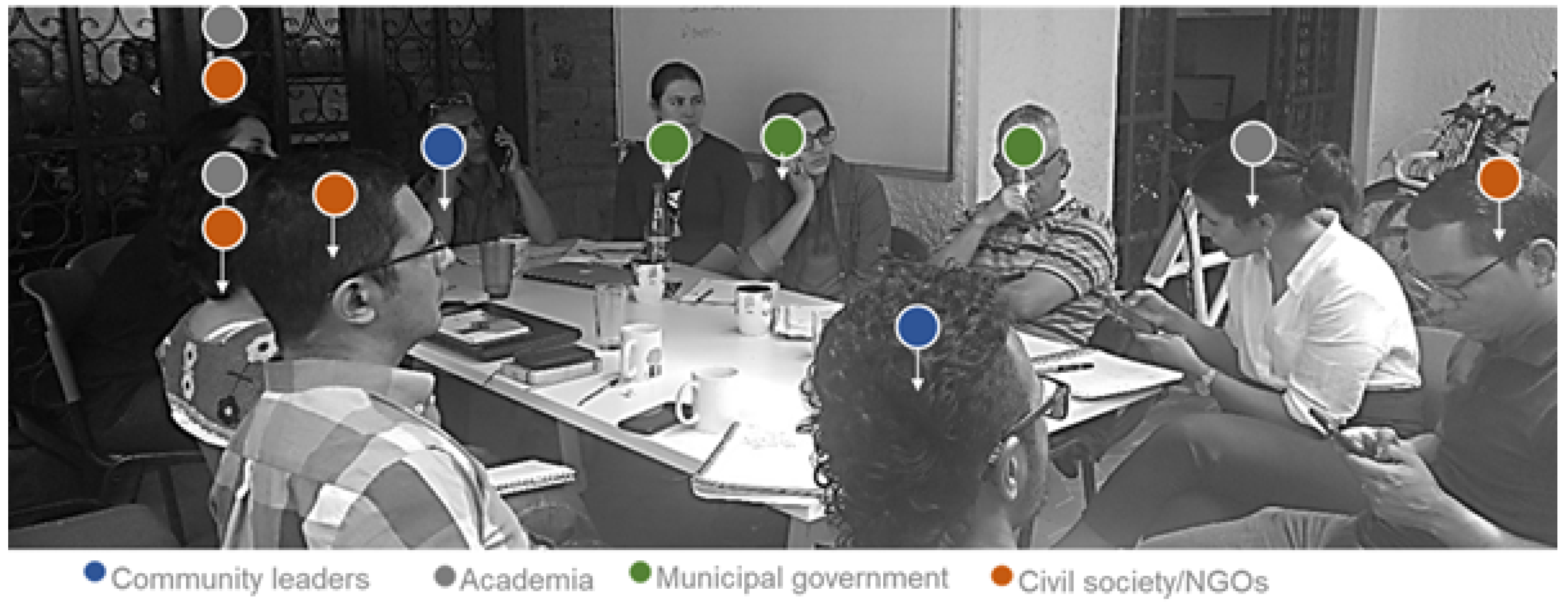
40]). The workshops and other activities, such as the construction of manual sensors, community walks, and emergency drills, were developed in order to strengthen the different components of the LEWS. Additionally, regular monthly meetings were held with representatives of all Colombian partners, in order to discuss the planned activities (
Figure 5).
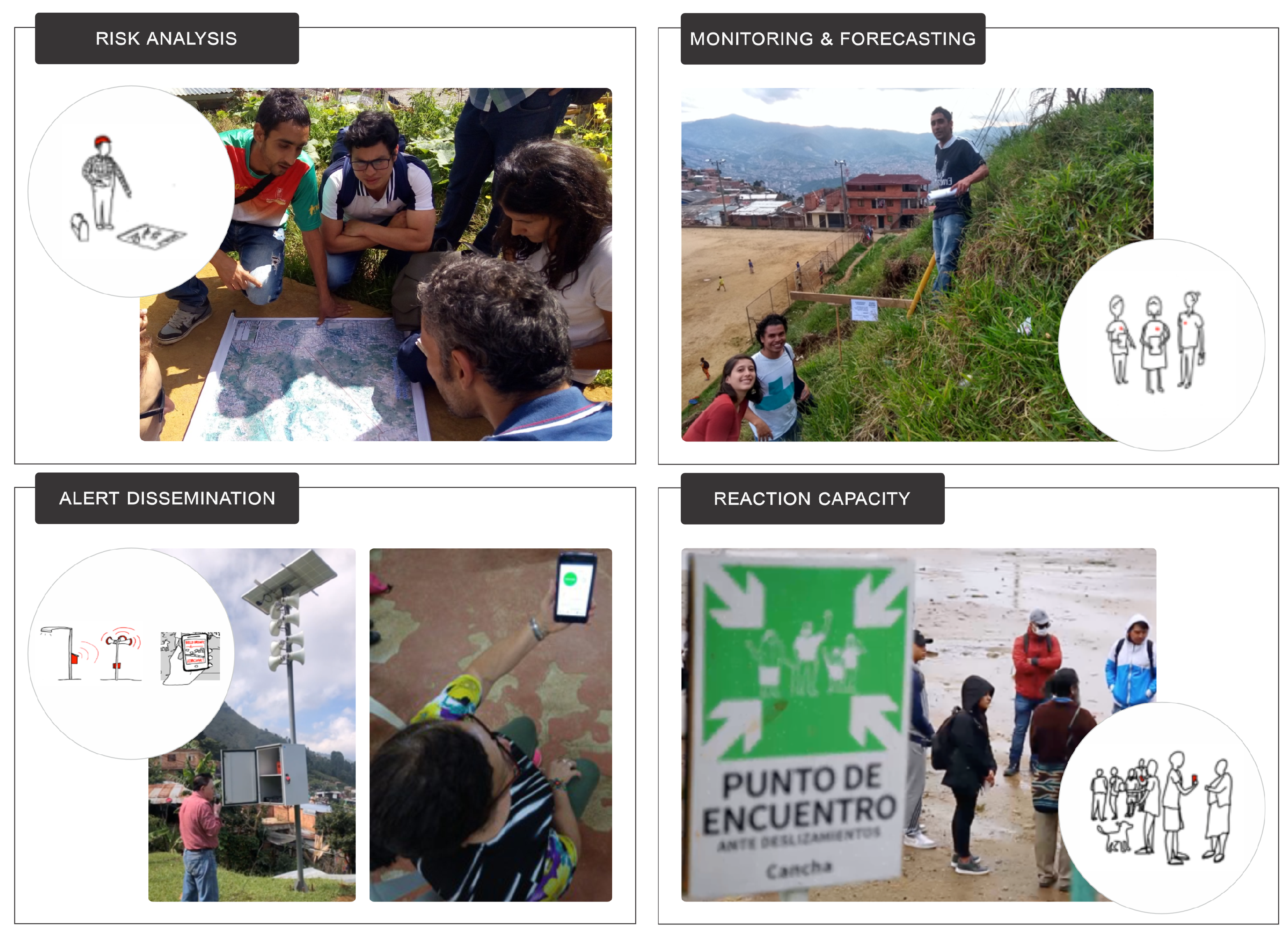
To explain how the risk analysis of the system works, several workshops were held with the local community and civil society organizations (
Figure 6 upper left). In these, the results of the geological analysis were shown, historical landslide events were discussed and risk factors of the area were identified, in order to reduce them (e.g., leaks in water pipes, incorrect construction techniques, etc.). Additionally, walking tours of the neighborhood were conducted with the participation of technical professionals and members of the community, to identify risk factors, thus allowing for an exchange of knowledge.
Regarding monitoring and forecasting (
Figure 6 upper right), some manual monitoring elements were implemented with the community, and automatic sensors were explained in detail. These manual elements usually work in the manner of self-built crack-meters, where deformation is measured manually and marked directly on the instrument. There was also intensive work on identifying the visual signs of a landslide (e.g., cracks, tilted trees, water poles, etc.), since community monitoring is one of the most important elements within the system. Another strategy was to identify, together with the community, what we called “godparents” of the sensors. These are people who live near a sensor and volunteer to take care of it. This mainly involves a regular visual control of the sensor and giving notice if there is an apparent alteration to the sensor or it’s protection element.
Multiple alert dissemination channels were implemented with the community (
Figure 6 lower left), in order to increase redundancy regarding this part. The channels comprised the use of WhatsApp groups, door-to-door alert notices between nearby neighbors, push messages through the Inform@Risk app, messages played through a large sound system installed in the upper part of the area, and a siren system.
To address the response capacity (
Figure 6 lower right), evacuation routes and five meeting points located in stable areas, as defined by the hazard assessment, were identified and marked. Multiple exercises were carried out, to define the actions to be taken at the different qualitative alert levels, defined with the community. These exercises included theoretical risk scenarios and the development of two evacuation drills, designed and developed together with the risk management authority and local civil society organizations.
Since the LEWS was developed in an informal settlement, it was relevant to identify the power relationships among the different actors, including those with governmental, legal, and illegal roles. This implied constant and open communication, in order to gain and maintain trust among the different actors. One of the key actors in the community training and the social power management were the local civil society organizations of the area [
55]. Some of the civil society organizations that supported the development of the LEWS had been working with the community for several years, so they had a deep understanding of the social structures and needs.
3.4. Socio-Spatial Integration of LEWS
Based on the guidelines mentioned in
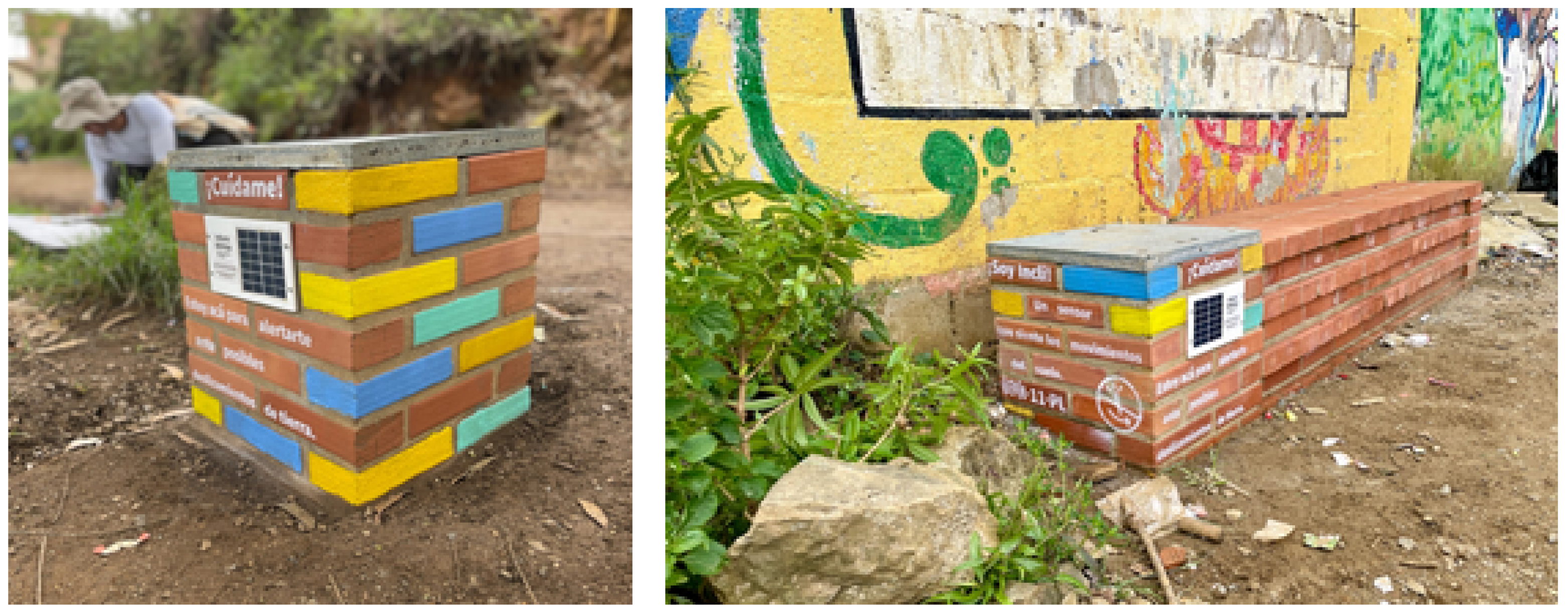
Section 2.4, an integrated concept for public space interventions was developed. The main material chosen for constructing the benches and seats in Bello Oriente was red brick, as it is resistant to tropical weather conditions and is a well-known constructing material in the neighborhood. As one project goal was to build a low-cost system, not all sensors were protected with a bench construction, in order to save costs. Sensors located on steep slopes in remote areas were protected with a low-cost enclosure, a simple plastic pipe (
Figure 4). Sensors near pathways and streets, where people walk by, had a medium size set up, in our case a small brick seat (
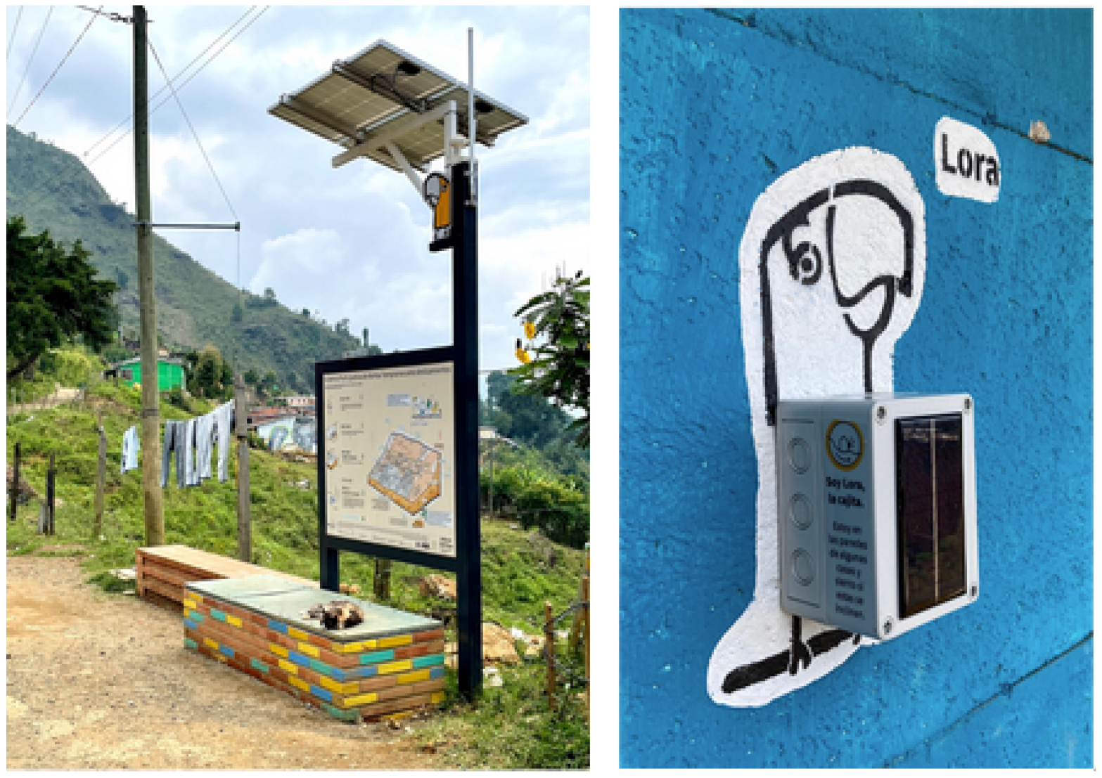
Figure 7, left). Together with residents, the places for building benches and seats were chosen at socially and spatially suitable places, where people could meet and benefit from them. As a special part of the monitoring system, Gateway B (
Figure 8) was designed as an informative meeting space. A large bench was paired with a steel construction holding the antennas, the solar panel, and a sign showing more detailed information about landslide risk and the LEWS (
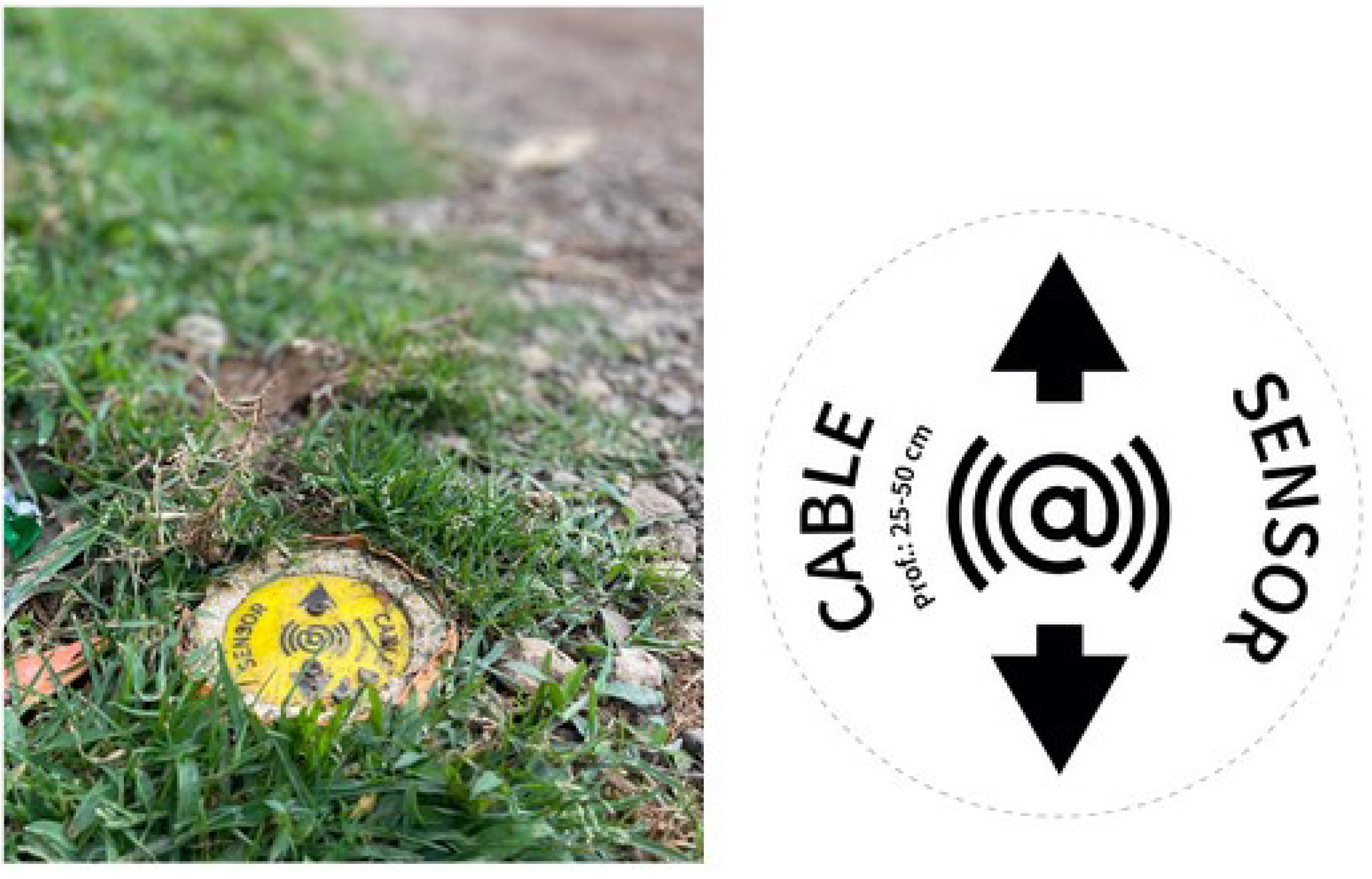
Figure 8, left). To add environmental elements and also to increase residents’ responsibility and awareness for these places, micro gardens and trees were planted next to the benches. To protect the horizontal CSM lines from external disturbances, such as future construction activities, simple point markers every 3 to 5 m display their location (
Figure 9).
For all sensor types, an overall communication strategy was developed. Easy-to-understand characterizations explain the landslide risk and how the slope is monitored. As an example, the short form “LoRa
®” means “parrot” in Spanish. Through simple wall paintings of “Lora the parrot” paired with the technical LoRa
® box, the infrastructure nodes are visibly spread in the upper part of the neighborhood and serve as an important recognition feature for the integrated LEWS (
Figure 8, right).
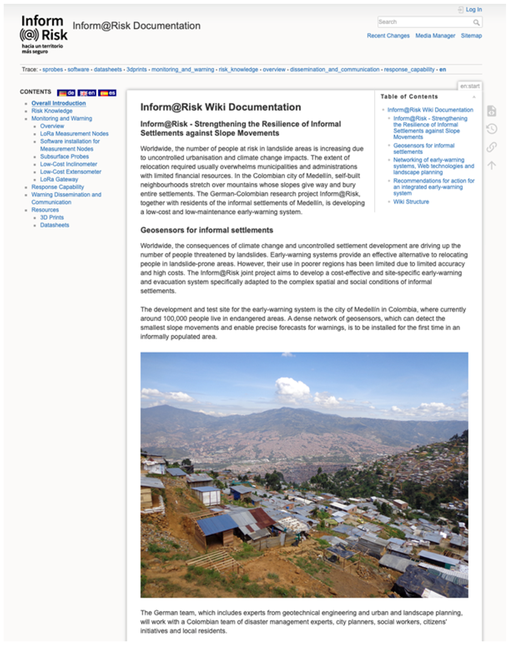
3.5. The Inform@Risk Wiki
In order to make the monitoring part of the proposed LEWS as easily replicable as possible, we have compiled all necessary information on a wiki page under:
www.informatrisk.com (accessed on 10 June 2023) (
Figure 10). For the technical parts of the measurement system described in the last section, we created material lists, installation/construction manuals, as well as datasheets, where necessary. The necessary steps to construct the sensors and install them in the field are explained in detail using pictures from example installations, as well as graphical descriptions. All newly developed parts of the monitoring system are published open source (
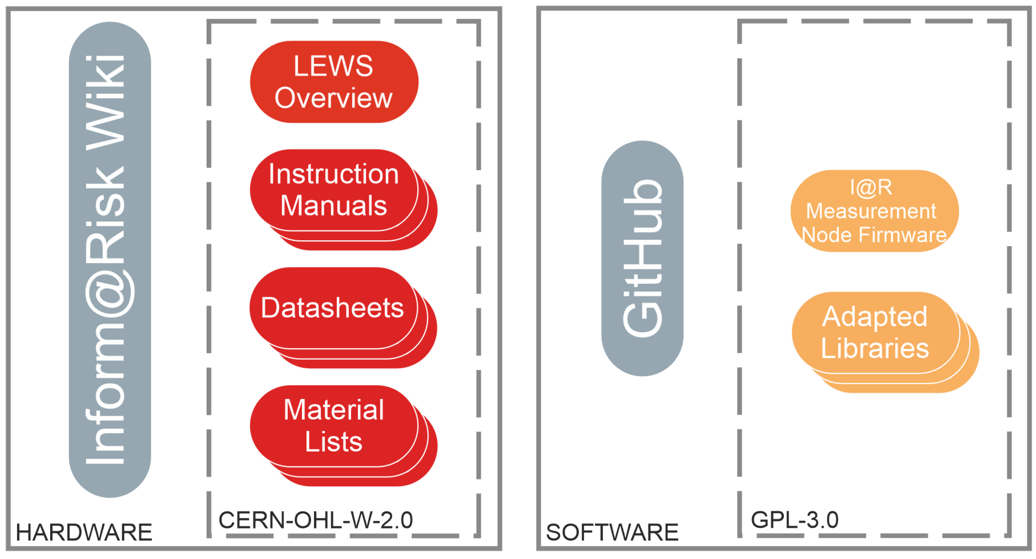
Figure 11).
To provide flexibility, as well as easy replicability, the sensor designs rely on 3-D printed parts. The 3-D designs are also available on the wiki and can be accessed and modified easily using open-source or free software, such as Blender or Ultimaker Cura. For example, the 3-D printed parts of the subsurface nodes in small drillings were designed for a casing diameter of 1.25”, but could easily be adapted to, e.g., casings of 1.5” or 2” diameter. These general descriptions should allow anyone with basic knowledge of electronics and 3-D printing to replicate the sensors.
The basic measurement node, on which all sensors rely, consists of a printed circuit board (PCB) with about 100 components, the design of which is also available on the website, including the circuit schematics as a PDF and fritzing files. This should allow easy future modification, if for example additional or updated sensors need to be added. Nonetheless, the design can be taken and used as is.
The provided firmware for the nodes can be used for both the infrastructure nodes and subsurface measurements. The documentation for the firmware is hosted on a GitHub page, while the installation of the software on one’s personal computer is described in an instruction manual, which is hosted on the project wiki website. The necessary software to install the firmware on the nodes comprises the Arduino development environment (IDE, Arduino [
56]) and various Arduino libraries, most of which can be downloaded directly in the IDE, while some of them were written specifically or adapted for the measurement nodes. The latter can also be downloaded from the project wiki website. To make the code as easily accessible as possible, it is distributed via GitHub:
https://github.com/moritzgamperl/informrisk-lora-node/ (accessed on 10 June 2023). In this way, changes can easily be made by other contributors. The firmware was written in a way such that it can mirror the flexibility of the nodes themselves: additional sensors can be turned on or off, and the node can be used without any attached sensors (even without an inclination sensor) as something similar to a “smart home” sensor that measures temperature and barometric pressure. On the other hand, both analog (12 or 24 bit ADC) and digital (I2C, SPI, and serial (TTL) ports) sensors can easily be attached. For example, we used the node not only for its intended functions but also to control and monitor gateways (serial communication) and measure their voltage and current consumption, to measure extensometers (linear potentiometer measurement) and piezometers (4–20 mA current loop measurement) in drillings of up to 50 m depth, and to control a siren system on site (relay).
Descriptions on how to perform low-cost extensometer measurements are also given in an additional document hosted in the wiki. The measurements themselves must be performed using a commercial wire potentiometer, but the wire suspension and guiding can be carried out using simple 3-D printed parts and some easily available basic construction parts. The laying of the wire itself in a horizontal measurement line is also delineated. The measurements can be made using the Inform@Risk measurement nodes, utilizing the required firmware provided on the GitHub page. The CSM system that was installed for the Inform@Risk project, on the other hand, is more difficult to replicate because of the sophisticated software needed, the large amount of data produced, and the high effort required for cable and measurement instrument installation in trenches and shafts.
General descriptions are also given on how to install and operate a LoRa
® gateway. In general, any commercially available LoRa
® gateway could be used. However, as continuous interruption-free operation is essential, many things need to be considered when installing the gateways, including signal reception, power supply and storage, data storage, internet connection, redundancy and remote control of the main components and system protection. Consequently, gateways usually have a highly individualized design, adapted to the specific installation site. Furthermore, it is advisable to socially integrate these essential systems into the public space, as we believe this will greatly increase the reliability of the system (see
Section 3.4). Therefore, it is difficult to give specific guidelines on this part of the system. However, the general system considerations and a general overview of which devices are needed and how they can be installed and operated can be given on the wiki. The same is true for maintenance, which should ideally also be performed by local risk agencies [
57].
4. Recommendations for LEWS Based on the Experiences of the Inform@Risk Project
In the international norm ISO 22327, general guidelines are given for community-based early warning systems [
58]. The Inform@Risk LEWS follows these guidelines and has developed specific implementations for the different system elements, adapted to the local needs of our project area in Bello Oriente, Medellín, Colombia. From these experiences, we have developed recommendations for the implementation of LEWS for informal settlements with a community-centered approach (the difference with a community-based early warning system being that there is a greater focus on the monitoring system), which are considered to supplement the general guidelines of ISO 22327.
4.1. Risk Assessment
Often detailed data for area-wide risk assessments is not available, so in the first stage of setting up a LEWS, detailed geological, geotechnical, and social surveys usually need to be performed. Which methodology to use and what level of quality and detail can be achieved depends on many factors, including the type and quality of existing data; local experience/know-how; the usual risk management practice in the region; and the available money, time, and personnel. Nevertheless, the generation of the following elements is considered essential as a data basis for building a LEWS:
A geological map and report, describing the distribution and characteristics of all lithological units and geological structural elements;
A phenomenological map or landslide inventory, showing all geological and morphological traces, as well as historic information concerning past and current landslide activity;
A landslide hazard map and report, which—based on the above surveys—rates all recognized and relevant landslide processes, concerning their probability and magnitude (landslide hazard);
A socioeconomic study detailing the exposed elements, including the number and type of elements at risk, namely the number of inhabitants, buildings, roads, vehicles, and livestock;
A building inventory listing the construction type and usage of the buildings on site;
A socioeconomic vulnerability analysis;
An assessment of the current state of landslide risk perception and disaster preparedness of the community.
Before starting these surveys, we strongly recommend getting into contact with community leaders and any existing organizations (aid organizations, NGOs, etc.) already working in the community and involving them in the planning of the activities.
The community should be informed about the activities (community meetings, leaflets, public walks, etc.) and should be asked to support the efforts, e.g., by accompanying the geological and social surveys or by giving information about their experiences of past landslide events. These activities should be placed within the overall strategy concerning the dissemination and communication of knowledge.
4.2. Monitoring and Early Warning
Landslide monitoring and early warning systems always need to be designed by a landslide expert and specifically for the landslide processes and geological and topographic conditions present in the project area. The Inform@Risk sensor system, for example, was designed for situations where the failure location of future landslides within a large high risk area cannot be predicted and, thus, a priori sensor placement is impossible. This typically is the case for small to medium sized rainfall-induced landslides in soil. The following recommendations, consequently, are limited to this scenario.
The placement of the deformation sensors in the project area is defined based on the results of the hazard and risk analysis. The goal is to achieve an area-wide coverage of the high-risk area by distributing the sensor nodes (I@R geosensor network) and sensor cables (CSM/EXT) throughout the affected area. The average distance between two sensors should, on average, be less than the diameter of the expected typical landslide (e.g., within a 10-year repeat period). However, to keep the system efficient, the sensor density should be varied based on the risk. Thus, in places where the population density is the highest or buildings of special relevance are present (e.g., schools), more sensors are placed, while in less-populated areas, the number of sensors per area can be decreased. It is essential to also consider the run out of potential landslides originating in high-hazard slopes (which might be classified as low risk due to a lack of exposed objects) above the populated areas. While the overall number and distribution of sensors is determined statistically, the exact placement of each individual sensor on site must be optimized considering the following:
High probability the sensor will be able to detect the initial movements of a landslide (e.g., attach inclination sensor objects that are shallow in the affected soil);
Protection from vandalism and other outside influences (e.g., outside the reach of children and animals);
If applicable, minimize shadowing of solar panels by neighboring objects throughout the day;
If applicable, ensure that a wireless link to the central station can be established.
There may also be social factors (such as unwillingness of an inhabitant to place a sensor on their house) that influence the sensor placement to a significant degree. If this is the case, the social angle has to be weighed against the other factors, to find the best overall solution. In many cases, the social component will outweigh the technical issues. The monitoring component should not be limited to sensors and automatic instruments. It is highly relevant to help the community at-risk to develop visual and hearing monitoring capacities. By constantly looking for changes in the slope and weather, as well as looking for potential mass movement signs (e.g., leaking pipes, incorrect constructions), risk awareness increases and the monitoring with automatic instruments is complemented.
The topic of dissemination of alerts, in particular, concerns both technical and social issues. In the Inform@Risk project, an app was used in combination with a WhatsApp group. While an app can provide much more information than “traditional” dissemination methods, in our project, it did not prove easy to distribute information [
40]. Thus, dissemination methods such as sirens should always be used and combined with other communication pathways such as door-to-door communication or smartphone apps, as redundancy. A sense of responsibility for the sensor system can be achieved by introducing, e.g., sensor godparenthood and maintenance of sensors by the community themselves.
4.3. Dissemination and Communication of Knowledge
As landslide risk is often only one of many problems for the affected communities (and by far not the most pressing problem), it is commonly difficult to raise awareness about landslide risk. While children can be addressed at school, by organizing workshops and preparing age-appropriate information materials, it can be difficult to reach the adult population. For example, community meetings on the topic are often poorly attended (few attendants), even if strong advertising efforts have been made (flyers, house-to-house information walks, etc.). Making the work on the LEWS and its structural components visible and recognizable in public places can, however, help raise awareness. The intention is that community members repeatedly encounter elements of the LEWS in their daily life and thus will be constantly reminded of the presence of the LEWS and its purpose. To facilitate this, the Infom@Risk project implemented the following strategies:
Development of a unique, noticeable design for all elements related to the LEWS. This included an information and education campaign (information signs, murals, leaflets, presentations, workshop invitations, giveaways, etc.), the technical components of the LEWS itself (sensor enclosures), and also the clothing of people related to the project in all phases of the work;
Placement of information signs at the entrance of the community and in highly frequented areas;
Placement of information signs near all noticeable working and construction activities, e.g., geological drillings, geophysical surveys, and construction work for the installation of the sensor system;
Improving public spaces by adding benches and seats, which also act as sensor enclosures and information signs;
For each warning level, there should be clear messages that describe the expected actions. These messages should use simple language and include specific details on what to do, where to go, etc. The warning levels with the messages should be widely distributed to the at-risk communities;
Get into contact with local civil society organizations, so they can include training activities related to the LEWS (risk knowledge, monitoring techniques, reaction capacity, etc.) in their agendas.
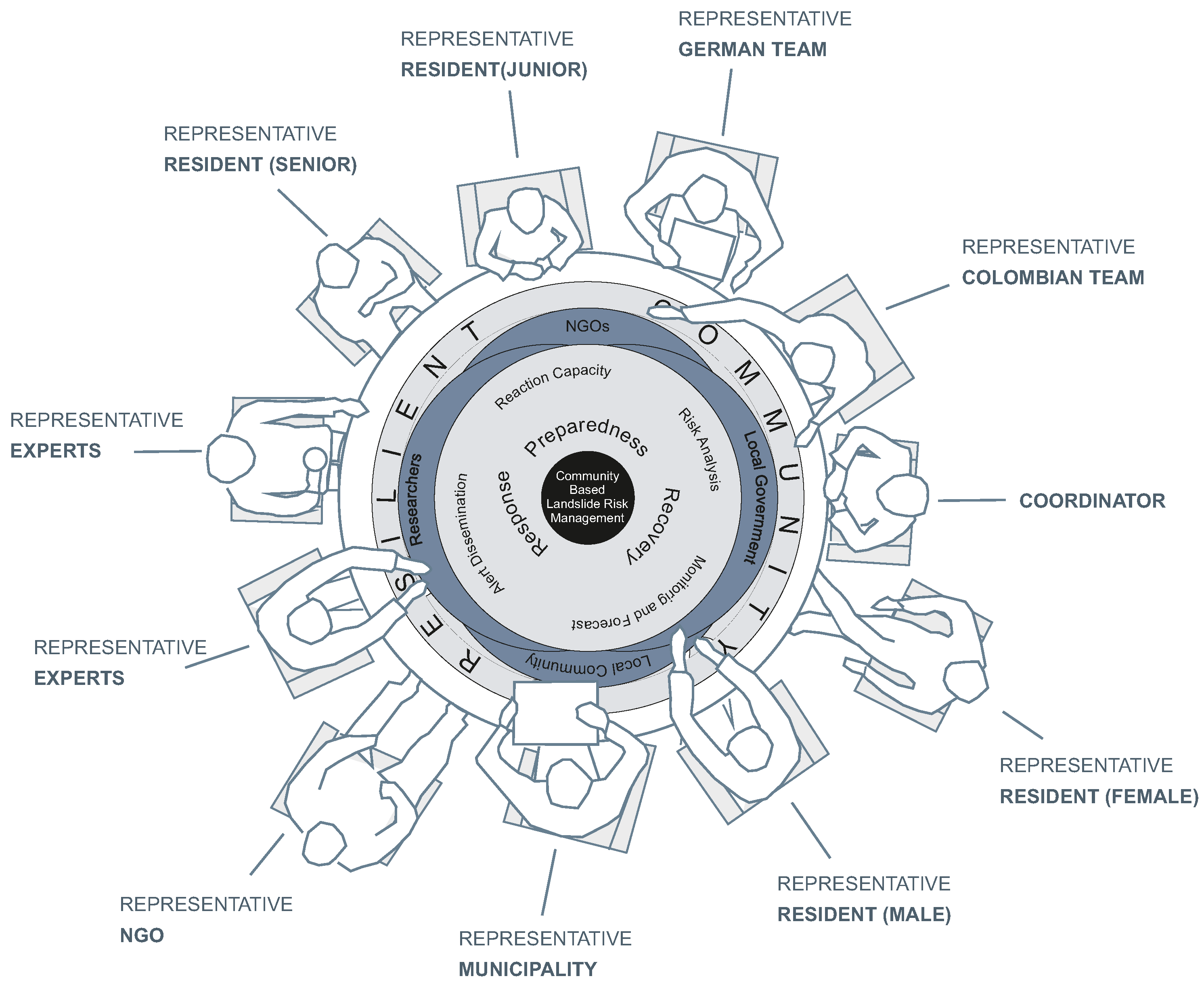
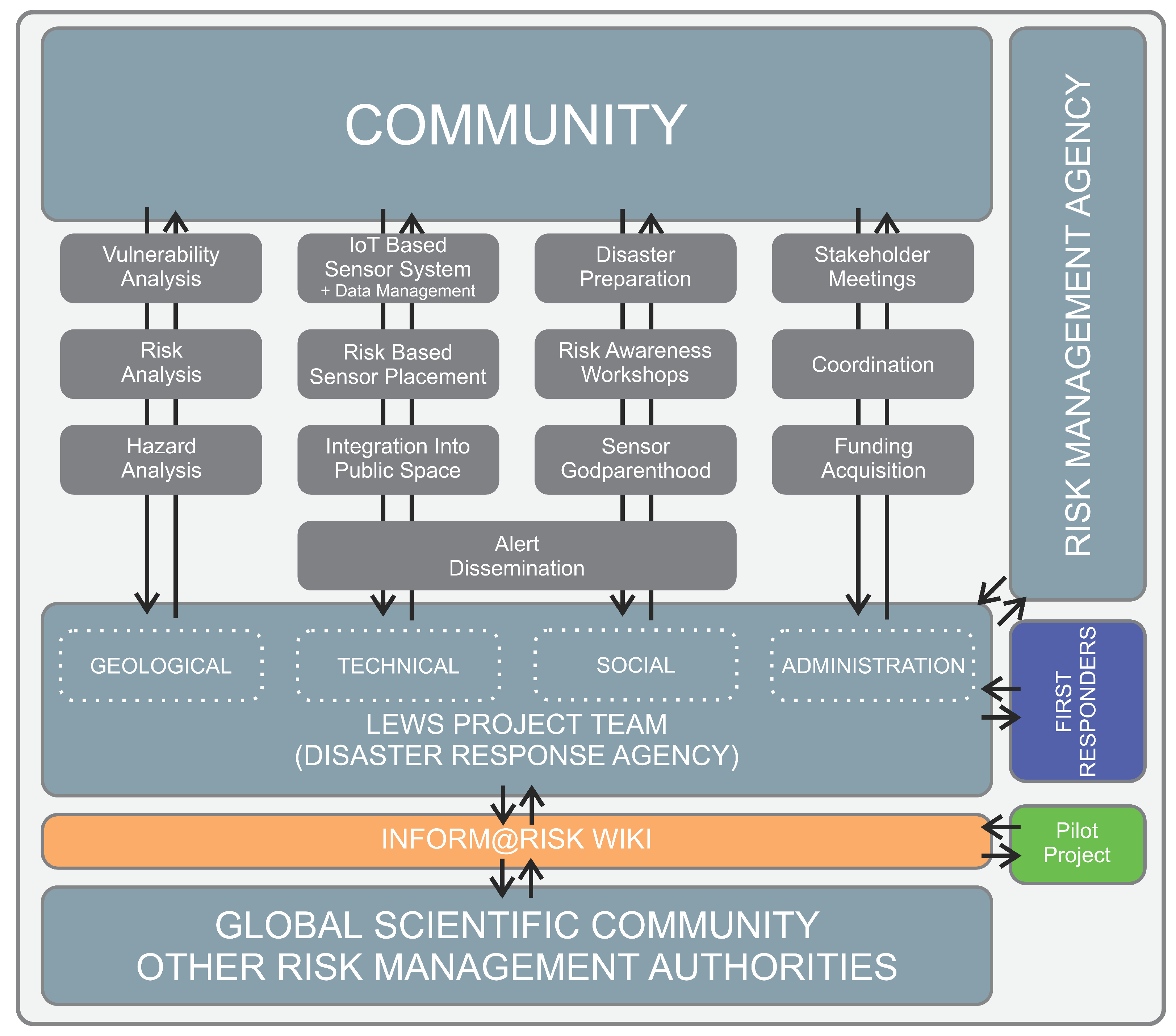
4.4. Organizational Framework of the Inform@Risk LEWS
The framework of the Inform@Risk LEWS is given in
Figure 12. We developed it based on our experience in Bello Oriente and also used some components of ISO 22327 [
58]. It is modular, so that it can be adapted to specific cases. For example, if a system is to be implemented in an area with rockfall hazard, the here-described technical components for monitoring shallow landslides can simply be exchanged for components that monitor rockfall. The framework is based on the experiences documented in our pilot project in Medellín, Colombia.
The two main parts of the LEWS are the local community (top) and the LEWS team (similar to the “disaster preparedness team” in the ISO, but with a stronger focus on monitoring). Together with local risk management authorities (which can also be a regional agency), civil societies, and first responders, various tasks in the four categories geohazards, technology, social, and administration are defined. Most of the sections are interlinked and dependent on each other.
The social dimension is present in all components, but there should be a focus on the topics of disaster preparation/response capability and risk awareness, which can be achieved through the methods described above. The main focus of administration should be to distribute information between the different stakeholders and to organize regular meetings between them. In addition, coordination of tasks should be central to administration. If necessary, this part of the project should also take care of finding funding for the specific project.
The new Inform@Risk wiki page, as described above, hopefully can be a tool for further development of the framework and for exchange between researchers and risk managers dealing with similar situations. Therefore, we designed it as an interface between our pilot project, the global scientific community, and users. The information currently on the wiki regarding the pilot project in Medellín, therefore, is meant to be a starting point for further improvements and amendments.
5. Discussion
We proposed and tested a LEWS that was specifically designed for informal settlements and socially and spatially integrated into the settlements. The first test installation in Medellín, Colombia showed that such a system might be technically feasible for authorities/decision makers, but substantial efforts have to be made with regard to the social aspects—an element of the LEWS where no shortcuts can be made. Positive relations between the authorities, civil society organizations, and the community are essential.
The design of the sensors, accompanied by the illustrative elements used in this project, allowed a better understanding and identification of the instruments by the at-risk community. The interventions that were carried out to improve public spaces (i.e., benches and seats), which incorporated sensors inside them, led to a positive acceptance in general terms. People use the benches and seats to meet friends and family or watch their children play, showing that a LEWS supported by public space design can contribute to social interactions in a neighborhood. The combination of benches or seats with informative elements such as short inscriptions and additional signs worked best in our case. The meeting spaces became important means of communication, since they promoted discussions about the LEWS and landslide risk in general. Strategies such as “sensor godparenthood”, inhabitants sponsoring and caring for sensors in the vicinity of their homes, can promote the adoption of the LEWS and guarantee that the system will be maintained over time. On the other hand, this requires continuous social and technical support by the local authorities, to maintain the integrity of the sensor system. Additionally, such areas constantly grow and construction activities can progress very quickly. Thus, it is important to consider materials and designs that do not serve as inputs for the construction of a home, because this increases the likelihood that the protective structures will be vandalized.
However, in individual terms, a few people felt that the location of some of these benches would become spaces for drug use and territorial focus points for the local gangs. It is therefore essential that, when replicating similar projects, joint planning is carried out with the community, in terms of locating infrastructure for the improvement of public space and to increase the knowledge transfer among the different actors and residents (e.g., through supplemental information campaigns).
At the time of writing, no technical instrument has been stolen or tampered with, which we consider a major achievement. We attribute this to the constant social process that has lasted almost four years, where the voices of all actors have been heard and considered.
In an effort to enable the replicability of the low-cost instrumental monitoring system, as well as the overall LEWS, a large quantity of information, in the form of documents, files, and manuals, has been made public on the Inform@Risk wiki page. The use of this wiki page allows anyone, anywhere to interact with us and voice criticisms or propose changes to the system. We hope that this can be the start of a truly participative approach to landslide early warning for communities that are suffering the most from these hazards.
5.1. Efficiency of Sensor System
Detailed investigations of the data produced by the system and their analysis and interpretation are outside of scope of this publication and will be published in the future. However, initial data already show that the low-cost sensors can produce data that are sufficiently precise to reflect initial movements in the subsurface, if placed in the right locations and with the proper methods. Further analysis of the data over the subsequent years will yield continuously improved thresholds, which in turn will increase the confidence in warnings. Especially for point measurements (LoRa nodes), automatic warnings (received by experts) are essential, because the amount of data from these sensors is too large to be monitored by experts every day. Data fusion methods have to be applied that both combine the sensor data of the same information in different areas (complementary sensor fusion) and of different sources, to increase reliability (redundant sensor fusion). Cooperative sensor fusion, on the other hand, combines information from different sources, in order to gain additional, more complex information (e.g., comparing trigger data from rain gauges with deformation data from inclinometers). These methods can help to exclude false positive warnings and increase early warning times. The expected warning times range from several hours to days from the initial failure initiation to the collapse of a slope. This still has to be proven by field data, once more substantial deformation data have been collected. The expected warning times are, in any case, much higher than the transmission intervals of the sensor system, so the necessary times can be achieved by the system.
A building density of about 250 people per ha or more might render the proposed monitoring system ineffective. In such areas, focusing on social work is expected to be a more efficient approach, as trained inhabitants will be able to identify signals of early landslide movements (cracks, tilting, jammed doors) more easily, as opposed to a technical system which, in these areas, might comparably produce many false readings, due to intentional or unintentional tampering. A technical monitoring system, on the other hand, is ideal in sparsely inhabited steep slopes above settlements with a small population.
The economic costs of this system or similar systems in the Medellín region were investigated in Sapena et al. [
57]. These costs, however, should only be invested if the limitations are clear: as the system is aimed at slopes with a generally high landslide hazard, but an unknown exact future landslide area, it can only detect the initial movement of landslides in areas with monitoring systems installed. If initial movements occur in areas deemed very unlikely during the hazard analysis, which are subsequently only monitored sparsely, the system might not detect these movements. In the same way, the system can only provide a certain density of point sensors (about one sensor every 20 m on average) without becoming economically infeasible. This means that smaller landslides can generally not be detected with certainty. If the risk management authority operates such a system in multiple areas of one metropolitan area, the effort required for operation can be greatly diminished, since gateways and other infrastructure can be shared if circumstances (e.g., distance and line of sight) permit. The same is true for the data management system, which is easily scalable.
5.2. Challenges of an Integrated LEWS
Informal settlements, present in many cities of the world, are often built in landslide-prone areas without building code. Where they are located in high hazard areas, resettlement is often not an option, due to high costs. An integrated LEWS can help to decrease the risk for these communities in the short- to mid-term. The system can only be developed by collaborating with local authorities, agencies, civil society organizations, and inhabitants, and it has to be tailored for them. Considering this, we have provided recommendations for the technical and social aspects, which are both adapted to the conditions on site. The latter is one of the most challenging parts, as conditions in informal settlements can vary a lot [
59].
The Living Lab Model has already proven to be an appropriate approach for this [
43]. Local people have to be involved during all steps of the development and implementation process (e.g., from the site investigation works); in this way, a sustainable increase in landslide hazard awareness can be achieved and the training for LEWS alarms can be started early.


 ,
, 


