Abstract
Water resources are the material basis for human social development. They play an essential role in human production and life. They are vital for the healthy growth of ecosystem services. The quantitative assessment of the water conservation (WC) function is of great significance to the management of regional ecosystems and the construction of ecological civilization. Gannan is an influential water supply area in the upper Yellow River Basin. Understanding the current status and future changes of its WC function can provide scientific support for the stable use and sustainable development of water resources in the upper Yellow River Basin; its ecological status is highly important. The present study quantitatively assesses the WC function of Gannan based on the InVEST model. It aims to explore the regional ecological compensation mechanism, enhance regional ecological regulation capacity and increase water supply by studying the trend in changes in the WC function and the influence mechanism. The results show that: (1) The overall trend in WC capacity in Gannan increased during the period 2000–2020. (2) The spatial distribution of WC in Gannan varies from year to year, but there is some similarity, showing a high degree in the southwest and a low degree in the northeast. (3) Climatic factors are the dominant factors underlying the spatial and temporal distribution of WC in Gannan. (4) The important areas of WC are located in the southwest and southeast of Gannan.
1. Introduction
Water resources are indispensable for human daily life as well as the social and economic development of society. At present, the consumption of water resources is increasing year by year, the demand is increasing and the shortage of water resources in some parts of the world is very serious, so the rational use and allocation of water resources has become a common global concern [1,2]. The water cycle is an important part of ecosystem functioning. Precipitation is intercepted, stored and made available for use or function in the environmental system for a certain period of time known as water conservation (WC). As an important water ecosystem service, the demand for WC is increasing against the background of high social and economic demand, rapid population growth and urban progress and global climate change. Regional WC relies on ecosystem types, soil types etc., within the ecosystem to interact with atmospheric precipitation and evapotranspiration, thus maintaining the internal hydrological balance. Spatially, WC is the regulation of the water cycle in terrestrial ecosystems at the vertical level, i.e., the interaction of precipitation and evapotranspiration with the vegetation canopy, the understory litter layer and the soil layer, which ultimately recharges the regional water supply in the form of surface runoff, subsurface runoff and loamy midstream flow or is stored within the system. In time, this is mainly in the form of storage of precipitation and flood mitigation, and in the form of groundwater recharge to rivers during low precipitation seasons, which can effectively protect water sources, reduce flooding and maintain healthy regional ecosystems [3].
Adequate understanding of the regional water resource conservation situation is an important prerequisite for WC and ecological security. In the current management of regional WC functions, in order to balance socio-economic needs and environmental protection requirements as far as possible, policy-makers, experts and scholars tend to divide important ecological barriers and WC areas into large regions, and carry out WC function zoning for the corresponding areas, using these sub-level areas chosen to undertake major ecological functions as the main focus of conservation, and focus on treatment and development. The main means of improving WC capacity is the search for vegetation types and their allocation patterns that are suitable for the area and increase effective water yield (WY) [4]. In addition, to carry out simulations of regional ecological WC functions in different contexts, researchers can study the relationship between key factors such as tree species composition, hierarchical structure, configuration, reasonable density and the water transfer function of WC forests under different site conditions that can help predict the future trends of regional ecological functions, which are a strong guarantee for the sustainable development of the region.
With recent advances in theoretical methods and hydrological models, mathematical methods and hydrological models have been introduced for quantitative assessment. Currently, commonly used models include the Algorithms for Recovery and Isolation Exploiting Semantics (ARIES) [5], the Soil and Water Assessment Tool (SWAT) [6,7] and the Integrated Valuation of Ecosystem Services and Trade-off (InVEST) [8,9], among others. Compared to other models, the InVEST model has better data sources and accuracy of results [10,11,12]. The InVEST model, the Integrated Valuation of Ecosystem Services Functions and Trade-offs model, is a comprehensive valuation of ecosystem services. The model was jointly developed by Stanford University, The Nature Conservancy (TNC) and the World Wide Fund for Nature (WWF). The InVEST model has been successfully applied in many countries and regions in Africa, Latin America, the USA, China and Indonesia. For example, the InVEST model was used to measure WY in the Wildcat Creek watershed in Indiana and the Upatoi Creek watershed in Georgia, and was compared with the SWAT model to analyze hydrological accuracy [13]. The applicability of the model to the North Carolina sub-basin in the USA was explored and the factors influencing it were analyzed [14]. The InVEST model was specifically applied to study water retention, carbon storage, habitat quality and biodiversity in a UK sub-catchment [15]. Applying the WaterYield module to the WY of Korean forests, another study showed that the water content of Korean forests is much lower than that of Korea, and analyzed the intra-annual and spatial variability of water content [16]. The InVEST model was also applied to an assessment of the spatial and temporal variability of the Yellow River basin WY as well as its reaction to precipitation and land use change, and it was found that precipitation has a strong influence on WY, while land use/cover change has a smaller influence on WY [17]. This not only facilitates scholarly research, but also provides a scientific basis for policy guidance for decision-makers.
Gannan is located in the upper Yellow River Basin and is blessed with rich natural resources with diverse ecosystems. Accurate evaluation of the region’s WC function is crucial to the rational use of the region’s water resources. It also provides a reference for regional land planning, determining zoning and protecting and restoring the water environment [18]. Over the long term, the special environmental and ecological problems caused by the particular geographical conditions and traditional production patterns in southern Gannan have led to a series of environmental and ecological problems, such as soil erosion, grassland degradation and geological disasters. These have seriously affected and restricted the ecological environment and sustainable socio-economic development of Gannan, and ecological restoration and regional economic development face challenges [19,20,21]. Recently, there have a been number studies on ecosystem services in the Yellow River Basin of China. However, not many studies have been conducted on the WC function of the upper Yellow River Basin. They are mainly single studies focusing on function and value assessment. Comprehensive studies that combine function assessment and importance zoning, etc., are lacking. In addition, the existing studies on WC functions have a relatively short time scale. A longer time series of analyses is needed to identify the main influences on regional WC functions and to study their response to environmental change.
Gannan is located in the upper Yellow River Basin of China, which has large areas of grasslands, forests and wetlands. It recharges 11.4% of the total runoff of the Yellow River. It has become an important water recharge area for the Yellow River and is an important part of the “Chinese Water Tower” [20,22]. By quantifying its WC function, this study provides a scientific basis for regional environmental and ecological planning and establishment. The specific targets for this study are as follows: (1) To analyze the spatial and temporal patterns of change in WC function in Gannan from 2000 to 2020. (2) To explore the differences in the degree of contribution of different influencing factors to WC function. (3) To carry out a classification of WC importance and spatial delineation, and to identify priority WC and key protection areas.
2. Materials and Methods
2.1. Study Area
Gannan is located on the northeastern edge of the Qinghai-Tibet Plateau and in the upper Yellow River Basin (100°46′–104°44′ E, 33°06′–36°10′ N) (Figure 1). The total area of the region is 4.5 × 10⁴ km2. The topography is higher in the northwest and lower in the southeast, sloping from northwest to southeast. The terrain is intricate and complex with mountains and valleys. The geological structure system mainly belongs to the eastern and western tectonics of the Qinling Mountains. Gannan is characterized by a continental seasonal climate. There is more precipitation, and the geographical distribution significantly varies. The average annual precipitation ranges from 400–700 mm. The average annual temperature is between 1–13 °C. The territory has abundant water resources. The main rivers are the Yellow River, the Tao River, the Daxia River and the Bailong River (collectively known as the Three Rivers and One River). The soil types are mainly brown, calcium, meadow and swampy soils. The vegetation types are vertically distributed, mainly alpine scrub, alpine meadows, subalpine coniferous forests and temperate coniferous broad-leaved forests [19].

Figure 1.
The location of Gannan.
2.2. Data Sources and Processing Methods
The main data required for this study were average annual rainfall, average annual potential evapotranspiration, soil depth, plant available water content, land use type, watershed boundary, the Zhang coefficient, topographic index, soil saturation hydraulic conductivity and flow coefficient [23,24]. The relevant underlying database sources are presented in Table 1. All data were resampled to a 100 × 100 m resolution and were projected with the WGS_1984_UTM_Zone_48N coordinate system. Biophysical parameters for individual land use types used for this study are presented in Table 2, which provides data on the name of each land use type, the presence or absence of vegetation, the plant evapotranspiration coefficient (Kc) and the root depth for each land use type [25,26].

Table 1.
Acquisition and preprocessing of the parameters.

Table 2.
Table of biophysical parameters.
2.3. Methodology for Evaluating the Water Conservation Function
2.3.1. InVEST Model—Water Conservation Calculation
The WY module of the InVEST model is an estimation method based on water balance. The amount of WY is obtained by subtracting the actual evapotranspiration from the amount of rainfall in the raster cell. The WY is corrected for topography, soil saturation hydraulic conductivity and other factors to obtain the WY of the area [12]. The InVEST model combines topographic factors and differences in soil permeability to assess the WC capacity, making the results more scientific. The model is flexible in terms of parameter adjustment and spatial expression of the assessment results [32]. The specific formula is as follows.
where Y(x) is the WY of grid x in mm. AET(x) is the actual evapotranspiration of grid x in mm. P(x) is the precipitation of grid x in mm.
where ω(x) is a non-physical parameter that characterizes the watershed. R(x) is the ratio of potential evapotranspiration to rainfall, also known as the drought factor. The equations for each parameter in the equation are as follows.
where ET0 is the potential evapotranspiration, or reference evapotranspiration (mm). AWC(x) is the effective water content of vegetation (mm), is the maximum soil depth (mm), is the maximum root restriction depth (mm) and PAWC is the plant available water content (mm). Once the WY has been obtained, the WC capacity can be obtained. The model for calculating WC capacity is as follows.
where Retention is the water content (mm). Velocity is the flow rate coefficient. TI is the topographic index. Ksat is the soil saturation hydraulic conductivity (mm/d). Drainage_area is the number of grids in the catchment. Soil_depth is the soil depth (mm). Percent_slope is the percentage slope.
The WC factor is the ratio of WC to precipitation. It indicates the effect of precipitation, vegetation type and different surface features on water availability. The higher the coefficient, the better the area’s ability to support water [33]. It is calculated as follows.
where WCC is the WC coefficient. Retention is the WC capacity (mm). P is the precipitation (mm).
2.3.2. Change Trend Analysis
The one-dimensional linear regression method was used to assess WC trends in Gannan from 2000 to 2020. For the raster data, each image element has a corresponding 20-year time series value, and the trend of individual image element reflects the spatial evolution characteristics [34]. It is calculated as follows.
where Slope is the linear trend rate of change. Values greater than 0 indicate an improvement of the WC function over the time series under study. Values less than 0 indicate a decline. n is the number of numerical years. i is the year series.
2.3.3. Spatial Delineation of Water Conservation Importance
The classification method of the importance for WC in Gannan was based on “Technical Guidelines for the Delineation of Ecological Protection Red Line” [35,36,37]. In addition, the classification of the importance of WC in Gannan was carried out by combining the quantile classification method in ArcGIS software [28,38]. Five importance grades were defined, such as areas of general importance (Grade I; <151 mm), areas of mild importance (Grade II; 151–232 mm), areas of moderate importance (Grade III; 232–293 mm), areas of high importance (Grade IV; 293–368 mm) and areas of extreme importance (Grade V; >368 mm).
3. Results
3.1. Inter-Annual Trends in Water Conservation
The precipitation, potential evapotranspiration, actual evapotranspiration, WY and WC of Gannan from 2000 to 2020 are shown in Figure 2. The mean annual precipitation in the study area during the study period was 791.44 mm, with an overall interannual trend of a slight decrease in precipitation at a rate of 1.79 mm/a. The mean potential evapotranspiration was 774.78 mm, with an increasing trend over the last 20 years at a rate of 3.29 mm/a. The lowest value of potential evapotranspiration occurred in 2003 (673.20 mm) and the highest value occurred in 2018 (925.86 mm). The mean annual actual evapotranspiration in the basin was 555.22 mm, with relatively stable inter-annual variability and an increasing trend of 0.83 mm/a. Thus, more than 70.15% of the annual precipitation in the basin was returned to the atmosphere through actual evapotranspiration.
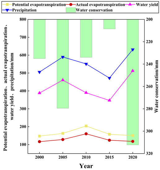
Figure 2.
Interannual variations of annual average precipitation, potential evapotranspiration, actual evapotranspiration, WY and WC in Gannan from 2000 to 2020.
From 2000 to 2020, the interannual variation in the average annual WC in Gannan and the regions is shown in Figure 3. During this period, the annual average WC in Gannan was about 90.04 × 10⁸ m3, with an overall increasing trend (13.70 × 10⁸ m3/10a). The maximum value was 110.77 × 10⁸ m3 in 2020 and the minimum value was 73.96 × 10⁸ m3 in 2015. The annual mean WC considerably varied between regions, with the highest in the southwest (23.37 × 10⁸ m3) and the lowest in the northeast (2.75 × 10⁸ m3). From 2000 to 2020, there was an overall upward trend in WC in all regions of Gannan. Southwest, northwest and east had more obvious upward trends (3.065 × 10⁸ m3/10a, 2.325 × 10⁸ m3/10a and 2.219 × 10⁸ m3/10a, respectively).
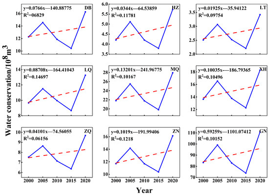
Figure 3.
Interannual variation of WC in Gannan and eight watersheds from 2000 to 2020 (DB: Diebe County; HZ: Hezuo City, LT: Lintan County, LQ: Luqu County, MQ: Maqu County, XH: Xiahe County, ZQ: Zhouqu County, ZN: Zhuoni County, GN: Gannan; Red dashed line: linear fit between time and regional WC).
The changes in the average annual WC coefficient for Gannan and the regions from 2000 to 2020 are illustrated in Figure 4. During this period, the average annual WC coefficient for Gannan was 0.462, with an interannual trend similar to the amount of WC, with an overall upward trend (1.48 × 10⁻²/10a). The maximum value was 0.494 in 2020 and the minimum value was 0.425 in 2010. The average annual WC coefficient considerably varied from region to region. South (0.518) > southeast (0.490) > east (0.480) > northwest (0.473) > west (0.454) > north (0.427) > southwest (0.424) > northeast (0.411). In terms of interannual trends, seven regions showed an increasing trend and one region showed a decreasing trend (Figure 4). Among them, the WC coefficients of the southwest and west showed a more obvious upward trend (0.83 × 10⁻²/10a and 1.66 × 10⁻²/10a, respectively), indicating that the WC function in these two regions gradually increased. In contrast, the WC coefficient for the southeast showed a decreasing trend (−6.45 × 10⁻²/10a), indicating a gradual weakening of the WC function in this region.
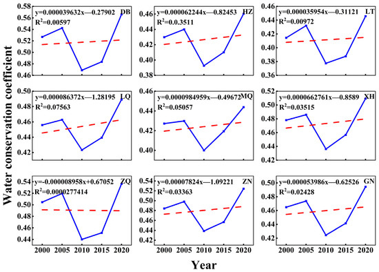
Figure 4.
Interannual variations of WC coefficient in Gannan and eight watersheds from 2000 to 2020. (DB: Diebe County, HZ: Hezuo City, LT: Lintan County, LQ: Luqu County, MQ: Maqu County, XH: Xiahe County, ZQ: Zhouqu County, ZN: Zhuoni County, GN: Gannan; Red dashed line: linear fit between time and regional WC coefficient).
3.2. Spatial Distribution of Water Yield and Water Conservation
3.2.1. Spatial Distribution Characteristics of Water Yield
A spatial distribution of WY in Gannan from 2000 to 2020 is shown in Figure 5. During this period, the spatial distribution of WY did not change much, showing a trend of high in the southwest and low in the northeast. However, the average annual WY considerably varied from region to region. The area with the highest average annual WY was the southwest (498.12 mm) and the area with the lowest average annual WY was the southeast (352.48 mm). Areas of higher WY were mainly in the southwest (498.12 mm) and west (438.25 mm). Areas of medium WY were generally in the northwest (399.13 mm), north (388.01 mm), south (387.13 mm) and east (385.25 mm). Areas of low WY were located in the northeast (354.60 mm) and southeast (352.48 mm).
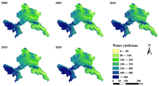
Figure 5.
Spatial distribution of WY in Gannan from 2000 to 2020.
3.2.2. Spatial Distribution Pattern of Water Conservation
An indication of the spatial distribution of the average annual WC in Gannan from 2000 to 2020 is shown in Figure 6. During this period, the spatial distribution did not change much, similar to that of WY. There was a downward trend from southwest to northeast. The high-value areas of WC were mainly in the south (287.14 mm) and southeast (271.94 mm). The middle-value areas were mainly in the southwest (255.75 mm), west (252.94 mm) and east (252.43 mm). Low-value areas were mainly in the northwest (243.33 mm), north (216.64 mm) and northeast (204.85 mm).
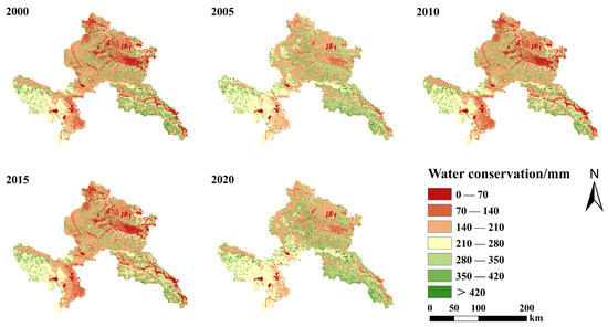
Figure 6.
Spatial distribution of WC in Gannan from 2000 to 2020.
3.3. Responses of Water Conservation to Key Factors
3.3.1. Responses of Water Conservation to Climatic Factors
The influence of climatic elements on the regional WC is mainly reflected in precipitation and evapotranspiration. The highest levels of precipitation (631.51 mm), WY (512.44 mm) and WC (312.27 mm) were recorded in 2020, as shown in Figure 6. The year with the lowest precipitation was 2015 (472.26 mm), which was also the year with the lowest WY (346.92 mm) and WC (208.54 mm), indicating that precipitation is an important factor affecting WC. This is consistent with the correlation analysis results (Figure 7). The correlation coefficients between the WC and each influence factor are P (0.77) > Ksat (0.14) > V (0.12) > ASL (1.4 × 10⁻¹⁶) > TI (1.3 × 10⁻¹⁶) > PAWC (−0.02) > SD (−0.2) > PET (−0.62) > AET (−0.63). The spatial distribution of mean annual precipitation in Gannan is in accordance with that of the WC. It shows a tendency to be high in the southwest and low in the northeast. It also shows a decreasing trend from the upper to the lower reaches.
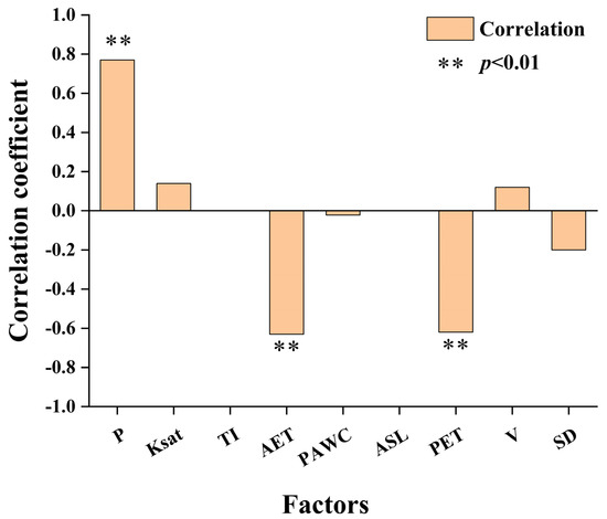
Figure 7.
Correlation analysis between the WC and the main climate factors (P: precipitation, Ksat: soil saturated hydraulic conductivity, TI: topographic index, AET: actual evapotranspiration, PAWC: plant available water content, ASL: elevation, PET: potential evapotranspiration, V: flow coefficient, SD: soil depth; WR: WC).
The actual evapotranspiration in Gannan remained relatively stable during this period, as shown in Figure 2. Spatially, actual evapotranspiration was higher in the southeast and south; i.e., sub-basins 1 and 7 (198.95 mm and 164.33 mm, respectively). The west and north, i.e., sub-basins 2, 4, 5 and 6, were relatively low, with the southwest, i.e., sub-basin 5, in particular having the lowest (103.61 mm) (Figure 8). Actual evapotranspiration showed an increasing trend from upstream to downstream, with a negative correlation with WC.
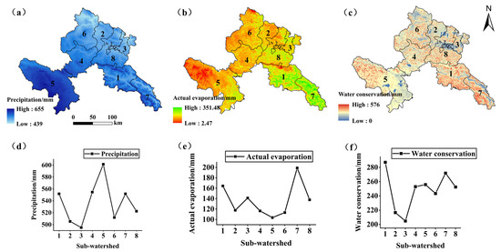
Figure 8.
Interannual variations of annual mean precipitation (a,d), evapotranspiration (b,e) and WC (c,f) in Gannan.
3.3.2. Responses of Water Conservation to Land Use Patterns
From 2000 to 2020, the land use structure of Gannan did not change much, as shown in Figure 9, with grassland and forest land dominating. Farmland, woodland, grassland, water, residential area and unused land account for 4.49%, 30.79%, 56.74%, 0.49%, 0.33% and 7.16% of Gannan, respectively.
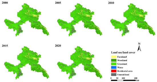
Figure 9.
Interannual variations in the land use/land cover in Gannan from 2000 to 2020.
In this study, the average WC and total WC for various land use types in Gannan were calculated for the period 2000–2020. The average annual WC of the six land use types was woodland > grassland > unused land > farmland > residential area > water (Table 3). The highest WC of the six land use types was found in 2020, with woodland (443.04 mm) > grassland (266.34 mm) > unused land (258.55 mm) > farmland (123.10 mm) > residential area (64.66 mm) > water (53.69 mm). The lowest WC was found in 2015 for woodland (282.95 mm) > grassland (184.84 mm) > unused land (175.32 mm) > farmland (81.63 mm) > residential area (45.58 mm) > water (35.07 mm). The total and average WC results for different land use types were similar, grassland > woodland > unused land > farmland > water > residential area (Table 3). Of these, grassland and woodland accounted for over 91% of the total WC in Gannan.

Table 3.
Total amount of WC of different land use types in Gannan from 2000 to 2020.
3.4. Spatial Classification of the Importance of Water Conservation
The spatial distribution of the importance of WC in Gannan is shown in Figure 10, with the western, northwestern, northern and northeastern parts being mainly Grade I and Grade II. The southwest is mainly Grade III and Grade IV. The eastern, southern and southeastern parts are mainly Grade IV and Grade V. Of these, Grade I is of general importance, Grade II is of relative importance, Grade III is of moderate importance, Grade IV is of high importance and Grade V is of extreme importance. Grade I, II and III areas are of relatively low importance for WC. These areas are mainly in the western and northern parts of Gannan. Areas with a WC capacity greater than 368 mm are considered to be of higher WC importance and require priority protection. These areas are mainly in the southeastern part of Gannan. Meanwhile, southwestern Gannan lies at the headwaters of the upper Yellow River Basin. It is the main flow area of the Yellow River. It covers a large area. The importance of WC is mainly tertiary and quaternary. It should also be protected as a priority (Figure 10).
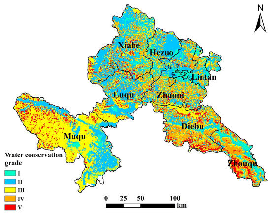
Figure 10.
WC grades of Gannan (Grade I: <151 mm; Grade II: 151–232 mm; Grade III: 232–293 mm; Grade Ⅳ: 293–368 mm and Grade Ⅴ: >368 mm).
4. Discussion
4.1. Spatial and Temporal Patterns of Water Yield and Water Conservation in Gannan
The average annual WY of Gannan gradually decreased from southwest to northeast from 2000 to 2020 (Figure 4). The area with higher WY is located in the southwest. This region is located at the source of the Yellow River, with abundant precipitation, relatively large grassland and wetland areas, and surface runoff easily formed after rain, leading to higher WY. Medium WY areas are located in the west, northwest, north, east and northeast. In these areas, forest vegetation cover is high. The forest canopy, dead branches and soil layers effectively intercept precipitation, thus reducing water production. The low WY area is located in the southeast. Low precipitation and frequent drought disasters in this region contribute to low WY [39]. In this study, it was found that as the vegetation cover in Gannan gradually increased from west to east, the interception of surface runoff also increased, which led to a gradual decrease in WY.
The spatial distribution of WC in Gannan is basically consistent with water production (Figure 5). Most of the areas with high WC are in the south, where the terrain is relatively flat. Since these areas are gently sloping, the water flow velocity decreases when it rains, which is conducive to soil loosening and water infiltration, and therefore, the WC is higher. The areas with low WC values are mainly located in the north and east. Due to the high mountains and steep slopes in these areas, the soil cover is low. In addition, the local farmland is large and the surface is exposed for a long period of time throughout the year, thus it is not conducive to WC. With the change in topography, surface runoff increases from north to south, soil absorption time is prolonged and its WC gradually increases [40,41].
4.2. Driving Factors Affecting the Regional Water Conservation Function
Regional WC function can be influenced by multiple factors [11,42]. Previous studies have shown that WC is a complex ecological process driven by the coordination of multiple factors. This is consistent with the results of the present study [43,44,45]. Considering the indicators and processes used in this study to calculate WC, precipitation, evapotranspiration, land use type and soil properties were considered as important factors influencing WC. This study further analyzed the factors affecting the spatial and temporal distribution patterns of WC in Gannan. According to the change characteristics of precipitation and WC in Gannan from 2000 to 2020 (Figure 2), the response of WC to precipitation in sub-basins of the study area (Figure 8), as well as the relationship between WC and other influencing factors (Figure 7), this study proves that precipitation is an important driving force of WC. These results are consistent with many other studies. For example, a global assessment of the sensitivity of runoff to changes in precipitation, potential evapotranspiration and other factors is based on the Budyko method. The study found that surface water resources are most sensitive to changes in precipitation on a global scale [43]. As WFcrop’s WFblue was higher than the world average, it was reduced by changing crop patterns or synchronizing crop planting and harvesting dates to periods favorable to precipitation [46]. A bottom-up approach was used to analyze the blue and green water footprints of the Upper Tigris River Basin (UTRB, Turkey) from 2010 to 2018. The results of the study found that reducing evaporation rates, capturing more rainwater and providing more advanced irrigation methods are the main preventive measures to reduce the water footprint of any basin [47]. Based on a comparative study of different regions, climatic factors, i.e., precipitation and evaporation, were found to be the most critical drivers of change in WC [32]. Precipitation in Gannan decreases from southwest to northeast, with the average annual precipitation in most areas being around 549 mm [48]. The overall precipitation in the Yellow River Basin has increased since the 21st century. The tendency to reduce runoff from the area has slowed. Evapotranspiration has decreased in 56.5% of the area [49,50,51]. With the significant increase in precipitation and the significant decrease in evapotranspiration, the WC is bound to increase. The correlation coefficient between WC and meteorological elements in the Gannan region is very significant, as shown in Figure 7. On the other hand, the correlation coefficients with other elements are not as strong or weak. This indicates that the change in WC is a complex combination of various elements. Of these, precipitation has a positive effect on WC, presenting a positive correlation to WC (0.77). Actual and potential evapotranspiration had a negative effect on WC, showing a negative correlation with WC (−0.63 and −0.62, respectively).
According to the water balance principle, WC can be seen to be the discrepancy between precipitation and evaporation. The close relationship between potential and actual evapotranspiration affects terrestrial water ecosystems [52,53,54,55]. The present study obtained a negative relationship between the two and WC. The results of this study found that different land use types tend to have different soil texture characteristics, which leads to differences in WC [56,57]. Water is transported through connected pores in the soil and the hydraulic properties of the soil are essential for the transport of water and solutes. The saturated hydraulic conductivity of soils increases with improved vegetation and community succession, and improved forest structure further enhances WC capacity [58,59]. The driving effect of vegetation on WC is complex and comprehensive, and the underlying reason is that the effect of vegetation on WC is a combination of soil water depletion and precipitation retention. The depletion of soil water by vegetation is mainly through the uptake of soil water by the root system and the transfer of water to the atmosphere through transpiration. Therefore, for land use types such as woodlands, the maximum root restriction depth and transpiration coefficient are usually high, thus weakening the WC function. The retention of precipitation by vegetation is mainly reflected in the retention of precipitation by the vegetation canopy and the retention of water by the apoplastic and soil layers, which is reflected in the flow rate coefficients of the WC calculation model. Apart from making use of these major factors, topographic factors were also considered in this study. Topography influences climate by impacting regional hydrothermal conditions. In turn, hydrothermal conditions affect the composition of the forest vegetation, the aggregation of bottomland plankton and the physical and chemical characteristics of the soil. Ultimately, this affects the WC capacity of the region [60,61].
4.3. Ecological Priority and Regional Management
The ecological environment of the upper Yellow River Basin is at a stage of partial degradation and overall improvement. This study assessed the WC of Gannan in the upper Yellow River basin from 2000–2020, with important implications for sustainable ecological conservation and water resource management in the region. The WC function was evaluated according to land type, ecological function and environmental value, and key protection areas in Gannan were identified. The potential areas could be highlighted in planning decisions and provide a reference for subsequent priority protection. The southwestern part is rich in rainfall, with little impact from human activities and with a large area covered by grasslands and wetlands. By optimizing the vegetation type and structure, the WC capacity of the area can be improved. The northeastern part is mostly arable land and construction land with flat terrain, which is more influenced by human activities. In view of the natural and socio-economic factors in Gannan, afforestation and optimization of vegetation in the area can improve the WC capacity of the area. As a central water source in the upper Yellow River Basin, Gannan has a very significant role to play in mitigating the increasingly severe water resource problems in the upper Yellow River Basin. Its WC function is of strategic importance to the strategic development and water resources management schemes of the region [62]. In this study, it was found that Gannan’s WC has generally improved in the past 20 years, indicating that Gannan’s WC function is being optimized.
By analyzing the spatial and temporal characteristics of WC in Gannan and its influencing factors, this study proposes the following countermeasures for promoting natural environmental management and economic and social development in the upper Yellow River Basin. (1) Build grass squares, create shrub belts, fence and seal, replant grass species and zone rotational grazing to improve grassland ecological benefits. (2) Strengthen the restoration and management projects of forest ecosystems, consolidate the achievements of returning farmland to forests and increase the area of vegetation cover. (3) Protect and restore wetland ecosystems, stabilize water recharge in the Yellow River and prevent downstream disruptions and flood storage. (4) Adhere to the ecological red line, implement key natural forest management and conservation projects in the ecological red line area and carry out the pilot construction of a comprehensive biodiversity observatory and grassland greening observation area.
5. Conclusions
Gannan is one of the important areas in the upper Yellow River Basin and is of strategic importance in terms of ecological environmental protection and water resources management in China. In this study, we quantitatively evaluated the WC in Gannan from 2000 to 2020, analyzed the spatial and temporal variation of WC, discussed its response to various factors and spatially divided the important areas. The results show that:
Changes in WC function are the result of a combination of climate, soil and land use. The correlation coefficients between the WC and each influence factor are P (0.77) > Ksat (0.14) > V (0.12) > ASL (1.4 × 10⁻¹⁶) > TI (1.3 × 10⁻¹⁶) > PAWC (−0.02) > SD (−0.2) > PET (−0.62) > AET (−0.63). The southwest and southeast are extremely important WC areas in Gannan (mainly Grade IV and V). We need to give adequate attention and priority to conservation. In the last 20 years, the amount of WC in Gannan has generally shown an increasing trend, and effective measures should continue to be taken to improve the quality of the ecological environment and enhance water resources protection. Therefore, this study recommends the implementation of an artificial climate project based on ecological restoration in the Gannan region of the upper Yellow River Basin to effectively monitor climate change dynamics. At the same time, a national nature reserve should be established in the southwestern part of Gannan to expand the ecological protection area centered in the southwestern part.
Author Contributions
X.C.: Conceptualization, Methodology, Software, Investigation, Data curation, Writing-original draft, Writing-review and editing. L.J.: Formal analysis, Supervision, Project administration, Funding acquisition, Writing-review and editing. X.Z.: Validation, Writing-review and editing. J.W.: Validation, Writing-review and editing. Q.L.: Validation, Writing-review and editing. All authors have read and agreed to the published version of the manuscript.
Funding
This research was funded by CAS “Light of West China” Program, grant number 2020XBZG-XBQNXZ-A, the Basic Research Innovation Group Project of Gansu Province, grant number No. 22JR5RA129, and the 2022 Major scientific Research Project Cultivation Plan of Northwest Normal University, grant number WNU-LKZD2022-04.
Data Availability Statement
All data sources analyzed in this study are included in this paper.
Acknowledgments
We would like to thank the colleagues in the Northwest Normal University for their help in the writing process. We are grateful to anonymous reviewers and editorial staff for their constructive and helpful suggestions.
Conflicts of Interest
The authors declare no conflict of interest.
References
- Portillo-Quintero, C.; Sanchez-Azofeifa, A.; Calvo-Alvarado, J.; Quesada, M.; Santo, M.M.D.E. The role of tropical dry forests for biodiversity, carbon and WATER CONSERVATION in the neotropics: Lessons learned and opportunities for its sustainable management. Reg. Environ. Chang. 2015, 15, 1039–1049. [Google Scholar] [CrossRef]
- Biao, Z.; Wenhua, L.; Gaodi, X.; Yu, X. Water conservation of forest ecosystem in Beijing and its value. Ecol. Econ. 2010, 69, 1416–1426. [Google Scholar] [CrossRef]
- Feng, D.; Wu, W.; Liang, L.; Li, L.; Zhao, G. Payments for watershed ecosystem services: Mechanism, progress and challenges. Ecosyst. Health Sustain. 2018, 4, 1434318. [Google Scholar] [CrossRef]
- Liu, Y.; Xiang, H.; Huang, Z.; Xiang, X.; Yu, Y.; Wang, M.; Li, Z. Analysis of leaf-architecture characteristics and ecological adaptability of tree species in the upper reaches of the Chishui River. Ecol. Indic. 2022, 135, 108563. [Google Scholar] [CrossRef]
- Villa, F.; Bagstad, K.J.; Voigt, B.; Johnson, G.W.; Portela, R.; Honzák, M.; Batker, D. A Methodology for Adaptable and Robust Ecosystem Services Assessment. PLoS ONE 2014, 9, e91001. [Google Scholar] [CrossRef] [PubMed]
- Mohammed, A.K.R. Modelling the impact of climate change on flow and E. coli concentration in the catchment of an ungauged drinking water source in Norway. J. Hydrol. 2019, 573, 676–687. [Google Scholar] [CrossRef]
- Qiu, L.J.; Zheng, F.L.; Yin, R.S. SWAT-based runoff and sediment simulation in a small watershed, the loessial hilly-gullied region of China: Capabilities and challenges. Int. J. Sediment Res. 2012, 27, 9. [Google Scholar] [CrossRef]
- Leh, M.D.K.; Matlock, M.D.; Cummings, E.C.; Nalley, L.L. Quantifying and mapping multiple ecosystem services change in West Africa. Agric. Ecosyst. Environ. 2013, 165, 6–18. [Google Scholar] [CrossRef]
- Jiang, X.; Xu, S.; Liu, Y.; Wang, X. River ecosystem assessment and application in ecological restorations: A mathematical approach based on evaluating its structure and function. Ecol. Eng. 2015, 76, 151–157. [Google Scholar] [CrossRef]
- Vigerstol, K.L.; Aukema, J.E. A comparison of tools for modeling freshwater ecosystem services. J. Environ. Manag. 2011, 92, 2403–2409. [Google Scholar] [CrossRef]
- Gao, J.; Li, F.; Gao, H.; Zhou, C.; Zhang, X. The impact of land-use change on water-related ecosystem services: A study of the Guishui River Basin, Beijing, China. J. Clean. Prod. 2017, 163, S148–S155. [Google Scholar] [CrossRef]
- Yang, D.; Liu, W.; Tang, L.; Chen, L.; Li, X.; Xu, X. Estimation of water provision service for monsoon catchments of South China: Applicability of the InVEST model. Landsc. Urban Plan. 2019, 182, 133–143. [Google Scholar] [CrossRef]
- Dennedy-Frank, P.J.; Muenich, R.L.; Chaubey, I.; Ziv, G. Comparing two tools for ecosystem service assessments regarding water resources decisions. J. Environ. Manag. 2016, 177, 331–340. [Google Scholar] [CrossRef]
- Hamel, P.; Guswa, A.J. Uncertainty analysis of a spatially explicit annual water-balance model: Case study of the Cape Fear basin, North Carolina. Hydrol. Earth Syst. Sci. 2015, 19, 839–853. [Google Scholar] [CrossRef]
- Redhead, J.W.; Stratford, C.; Sharps, K.; Jones, L.; Ziv, G.; Clarke, D.; Oliver, T.H.; Bullock, J.M. Empirical validation of the InVEST water yield ecosystem service model at a national scale. Sci. Total Environ. 2016, 569, 1418–1426. [Google Scholar] [CrossRef]
- Kim, S.W.; Jung, Y.Y. Application of the InVEST Model to Quantify the WATER YIELD of North Korean Forests. Forests 2020, 11, 804. [Google Scholar] [CrossRef]
- Yang, J.; Xie, B.P.; Zhang, D.G. Spatio-temporal variation of WATER YIELD and its response to precipitation and land use change in the Yellow River Basin based on InVEST model. Ying Yong Sheng Tai Xue Bao/J. Appl. Ecol. 2020, 31, 2731–2739. [Google Scholar] [CrossRef]
- Wang, Z.; Jiang, Q.; Fu, Q.; Jiang, X.; Mo, K. Eco-environmental effects of water resources development and utilization in the Sanjiang Plain, Northeast China. Water Sci. Technol. Water Supply 2018, 18, 1051–1061. [Google Scholar] [CrossRef]
- Xue, Z.Z.; Li, W.L.; Xu, D.D.; Xun, W.; Yang, Z.S. Research on eco-economic functional regionalization of important water supply region of the Yellow River in Gannan area. Chin. J. Eco-Agric. 2010, 18, 1093–1098. [Google Scholar] [CrossRef]
- Yue, M.; Wei, F.Z. Based on Energy Evaluation for Agricultural Ecological System of Gannan Tibetan Autonomous Prefecture. Res. Agric. Mod. 2009, 30, 95–97. [Google Scholar] [CrossRef]
- Yang, X.; Chen, R.; Meadows, M.E.; Ji, G.; Xu, J. Modelling WATER YIELD with the InVEST model in a data scarce region of northwest China. Water Supply 2020, 20, 1035–1045. [Google Scholar] [CrossRef]
- Yao, Y.; Deng, Z.; Yin, D.; Zhang, X.; An, H. Climatic changes and eco-environmental effects in the Yellow River important water source supply area of Gannan Plateau. Geogr. Res. 2007, 26, 844–852. [Google Scholar] [CrossRef]
- Sharp, R.; Chaplin-Kramer, R.; Wood, S.; Guerry, A.; Douglass, J. InVEST User’s Guide; The Natural Capital Project, Stanford University, University of Minnesota, The Nature Conservancy, and World Wildlife Fund: Stanford, CA, USA, 2018. [Google Scholar] [CrossRef]
- Xu, F.; Zhao, L.; Jia, Y.; Niu, C.; Liu, X.; Liu, H. Evaluation of WATER CONSERVATION function of Beijiang River Basin in Nanling Mountains, China, based on WEP-L model. Ecol. Indic. 2022, 134, 108383. [Google Scholar] [CrossRef]
- Sharp, R.; Tallis, H.T.; Ricketts, T.; Guerry, A.D.; Wood, S.A.; Chaplin-Kramer, R.; Nelson, E.; Ennaanay, D.; Wolny, S.; Olwero, N.; et al. InVEST User’s Guide; The Natural Capital Project: Stanford, CA, USA, 2014. [Google Scholar]
- Wang, X.; Wu, J.; Liu, Y.; Hai, X.; Shanguan, Z.; Deng, L. Driving factors of ecosystem services and their spatiotemporal change assessment based on land use types in the Loess Plateau. J. Environ. Manag. 2022, 311, 114835. [Google Scholar] [CrossRef]
- Cruz-Blanco, M.; Santos, C.; Gavilán, P.; Lorite, I.J. Uncertainty in estimating reference evapotranspiration using remotely sensed and forecasted weather data under the climatic conditions of Southern Spain. Int. J. Climatol. 2015, 35, 3371–3384. [Google Scholar] [CrossRef]
- Li, M.; Liang, D.; Xia, J.; Song, J.; Cheng, D.; Wu, J.; Cao, Y.; Sun, H.; Li, Q. Evaluation of WATER CONSERVATION function of Danjiang River Basin in Qinling Mountains, China based on InVEST model. J. Environ. Manag. 2021, 286, 112212. [Google Scholar] [CrossRef]
- Yang, B.; Zheng, H.; Ouyang, Z.; Zhuang, C.; Bo, J. Modeling hydrological ecosystem services and tradeoffs: A case study in Baiyangdian watershed, China. Environ. Earth Sci. 2012, 70, 709–718. [Google Scholar] [CrossRef]
- Kalma, J.D.; Mcvicar, T.R.; Mccabe, M.F. Estimating Land Surface Evaporation: A Review of Methods Using Remotely Sensed Surface Temperature Data. Surv. Geophys. 2008, 29, 421–469. [Google Scholar] [CrossRef]
- Yang, J.; Xie, B.; Zhang, D.; Tao, W. Climate and land use change impacts on water yield ecosystem service in the Yellow River Basin. China Environ. Earth Sci. 2021, 80, 72. [Google Scholar] [CrossRef]
- Wenmin, H.; Guo, L.; Gao, Z.; Jia, G.; Yi, L. Assessment of the impact of the Poplar Ecological Retreat Project on WATER CONSERVATION in the Dongting Lake wetland region using the InVEST model. Sci. Total Environ. 2020, 733, 139423. [Google Scholar] [CrossRef]
- Wang, Y.; Ye, A.; Peng, D.; Miao, C.; Di, Z.; Gong, W. Spatiotemporal variations in WATER CONSERVATION function of the Tibetan Plateau under climate change based on InVEST model. J. Hydrol. Reg. Stud. 2022, 41, 101064. [Google Scholar] [CrossRef]
- Shi, N.N.; Xiao, N.W.; Wang, Q.; Han, Y.; Gao, X.Q.; Feng, J.; Quan, Z.J. Spatio-temporal dynamics of normalized differential vegetation index and its driving factors in Xilin Gol, China. Chin. J. Plant Ecol. 2019, 43, 331–341. [Google Scholar] [CrossRef]
- Song, B.; Jing, L.; Li, H.; Feng, W. The Demarcation of Ecological Protection Red Line Based on Water Conversation Function. Ecol. Environ. Sci. 2017, 26, 1665–1670. [Google Scholar] [CrossRef]
- Xu, D.; Zou, C.; Xu, M.; You, G.; Dan, W. Ecological security pattern construction based on ecological protection redlines. Biodivers. Sci. 2015, 23, 740. [Google Scholar] [CrossRef]
- Li, W.; Ma, L.; Zang, Z.; Gao, J.; Li, J. Construction of ecological security patterns based on ecological red line in Erhai Lake Basin of southwestern China. J. Beijing For. Univ. 2018, 40, 85–95. [Google Scholar] [CrossRef]
- Bao, Y.; Ting, L.I.; Liu, H.; Tao, M.A.; Wang, H.; Liu, K.; Shen, X.; Liu, X.; Branch, N. Spatial and temporal changes of water conservation of Loess Plateau in northern Shaanxi province by InVEST model. Geogr. Res. 2016, 35, 664–676. [Google Scholar]
- Edwards, D.P.; Tobias, J.A.; Sheil, D.; Meijaard, E.; Laurance, W.F. Maintaining ecosystem function and services in logged tropical forests. Trends Ecol. Evol. 2014, 29, 511–520. [Google Scholar] [CrossRef]
- Yao, Y.B.; Wang, R.Y.; Deng, Z.Y.; Yin, D.; Chen, C.P. Climate Evolution and Its Impact on Water Resource Change in Main Runoff Generating Area of Upper Yellow River: A case study on Gannan Plateau. J. Desert Res. 2007, 27, 903–909. [Google Scholar] [CrossRef]
- Chen, L.; Zhu, A. Effectiveness Assessment of Soil Erosion Critical Source Areas for Soil and WATER CONSERVATION. J. Resour. Ecol. 2012, 3, 138–143. [Google Scholar] [CrossRef]
- Hao, L.; Chang, S.; Tingting, Z.; Peng, L. Trade-off and synergy relationships of ecosystem services and driving force analysis based on land cover change in Altay Prefecture. J. Resour. Ecol. 2021, 12, 777–790. [Google Scholar] [CrossRef]
- Berghuijs, W.R.; Larsen, J.R.; Emmerik, T.H.M.V.; Woods, R.A. A Global Assessment of Runoff Sensitivity to Changes in Precipitation, Potential Evaporation, and Other Factors. Water Resour. Res. 2017, 53, 8475–8486. [Google Scholar] [CrossRef]
- Jia, X.; Fu, B.; Feng, X.; Hou, G.; Yu, L.; Wang, X. The tradeoff and synergy between ecosystem services in the Grain-for-Green areas in Northern Shaanxi, China. Ecol. Indic. 2014, 43, 103–113. [Google Scholar] [CrossRef]
- Maurya, S.; Srivastava, P.K.; Gupta, M.; Islam, T.; Han, D. Integrating Soil Hydraulic Parameter and Microwave Precipitation with Morphometric Analysis for Watershed Prioritization. Water Resour. Manag. 2016, 30, 5385–5405. [Google Scholar] [CrossRef]
- Yerli, C.; Sahin, U. An assessment of the urban water footprint and blue water scarcity: A case study for Van (Turkey). Braz. J. Biol. 2021, 82, e249745. [Google Scholar] [CrossRef]
- Muratoglu, A. Water footprint assessment within a catchment: A case study for Upper Tigris River Basin. Ecol. Indic. 2019, 106, 105467. [Google Scholar] [CrossRef]
- Xu, L.; Li, Y.; Wang, L. Study on the Comprehensive Tourism Development Patternin Periphery Minority Area: A Case Study of Gannan Tibetan Autonomous Prefecture of Gansu Province, China. Popul. Resour. Environ. China 2007, 5, 43–50. [Google Scholar] [CrossRef]
- Lan, Y.; Wen, J.; Chang, J.; Xu, Y.; Lu, J. Possible change on the runoff in the upper Yellow River basin under global climate change. Sci. Cold Arid. Reg. 2009, 1, 157–164. [Google Scholar] [CrossRef]
- Lin, L.; Shen, H.; Sheng, D.; Xiao, J.; Shi, X. Response of runoff to climate change and its future tendency in the source region of Yellow River. J. Geogr. Sci. 2012, 22, 431–440. [Google Scholar] [CrossRef]
- Liu, Q.; Yan, C.; Zhao, C.; Yang, J.; Zhen, W. Changes of daily potential evapotranspiration and analysis of its sensitivitycoefficients to key climatic variables in Yellow River Basin. Trans. Chin. Soc. Agric. Eng. 2014, 30, 157–166. [Google Scholar] [CrossRef]
- Drexler, J.Z.; Snyder, R.L.; Spano, D.; Kyaw, T. A review of models and micrometeorological methods used to estimate wetland evapotranspiration. Hydrol. Process. 2010, 18, 2071–2101. [Google Scholar] [CrossRef]
- Lewis, C.S.; Allen, L.N. Potential crop evapotranspiration and surface evaporation estimates via a gridded weather forcing dataset. J. Hydrol. 2017, 546, 450–463. [Google Scholar] [CrossRef]
- Negash, W. Catchment dynamics and its impact on runoff generation: Coupling watershed modelling and statistical analysis to detect catchment responses. Int. J. Water Resour. Environ. Eng. 2014, 6, 2. [Google Scholar] [CrossRef]
- Or, D.; Lehmann, P. Surface Evaporative Capacitance: How Soil Type and Rainfall Characteristics Affect Global-Scale Surface Evaporation. Water Resour. Res. 2019, 55, 519–539. [Google Scholar] [CrossRef]
- Julian, J.P.; Gardner, R.H. Land cover effects on runoff patterns in eastern Piedmont (USA) watersheds. Hydrol. Process. 2014, 28, 1525–1538. [Google Scholar] [CrossRef]
- Sterling, S.M.; Agnès, D.; Polcher, J. The impact of global land-cover change on the terrestrial water cycle. Nat. Clim. Chang. 2013, 3, 385–390. [Google Scholar] [CrossRef]
- Zhao, X.; Wu, P.; Gao, X.; Lei, T.; Li, H. Changes of soil hydraulic properties under early-stage natural vegetation recovering on the Loess Plateau of China. Catena 2014, 113, 386–391. [Google Scholar] [CrossRef]
- Thakkar, A.K.; Dhiman, S.D. Morphometric analysis and prioritization of miniwatersheds in Mohr watershed, Gujarat using remote sensing and GIS techniques. J. Indian Soc. Remote Sens. 2007, 35, 313–321. [Google Scholar] [CrossRef]
- Gong, S.; Xiao, Y.; Xiao, Y.; Zhang, L.; Ouyang, Z. Driving Forces and Their Effects on WATER CONSERVATION Services in Forest Ecosystems in China. Chin. Geogr. Sci. 2017, 27, 216–228. [Google Scholar] [CrossRef]
- Wu, X.; Shi, W.; Guo, B.; Tao, F. Large spatial variations in the distributions of and factors affecting forest water retention capacity in China. Ecol. Indic. 2020, 113, 106152. [Google Scholar] [CrossRef]
- Xiao, Y.; Zhang, C.; Xu, J. Areas Benefiting from WATER CONSERVATION in Key Ecological Function Areas in China. J. Resour. Ecol. 2015, 6, 375–385. [Google Scholar] [CrossRef]
Disclaimer/Publisher’s Note: The statements, opinions and data contained in all publications are solely those of the individual author(s) and contributor(s) and not of MDPI and/or the editor(s). MDPI and/or the editor(s) disclaim responsibility for any injury to people or property resulting from any ideas, methods, instructions or products referred to in the content. |
© 2023 by the authors. Licensee MDPI, Basel, Switzerland. This article is an open access article distributed under the terms and conditions of the Creative Commons Attribution (CC BY) license (https://creativecommons.org/licenses/by/4.0/).