Review

Evolution of Floods: From Ancient Times to the Present Times (ca 7600 BC to the Present) and the Future

1
School of History and Culture, Hubei University, Wuhan 430061, China
2
Hellenic Agricultural Organization (HAO)—Demeter, National Foundation for Agricultural Research, Institute of Iraklion, 71307 Iraklion, Greece
3
Department of Civil Engineering & Architecture, University of Pavia, 27100 Pavia, Italy
4
Department of Engineering and Engineering Technology, Metropolitan State University of Denver, Denver, CO 80217, USA
5
Department of History and Classical Studies, School of Culture and Society, Aarhus University, 8000 Aarhus, Denmark
6
Civil Engineering Department, Faculty of Engineering, Islamic University of Madinah, Medina 42351, Saudi Arabia
7
Civil Engineering Department, Faculty of Engineering, Aswan University, Aswan 81528, Egypt
8
National Center for Studies and Research on Water and Energy, Cadi Ayyad University, Marrakech P.O. Box 511, Morocco
9
Department of Agriculture, School of Agricultural Science, Hellenic Mediterranean University, 71410 Iraklion, Greece
10
Department of International Water Resources, Izmir Institute of Technology, Izmir 35430, Türkiye
11
College of Agricultural Engineering and Technology, SKUAST—Kashmir, Srinagar 190025, India
12
Institute of Construction and Environmental Engineering, Seoul National University, Seoul 08826, Republic of Korea
13
Department of Geography, University of Bonn, 53115 Bonn, Germany
14
Department of Civil Engineering, Izmir Institute of Technology, Izmir 35430, Türkiye
15
Natural Resources Management and Agricultural Engineering Department, Agricultural University of Athens, 11855 Athens, Greece
*
Authors to whom correspondence should be addressed.
Land 2023, 12(6), 1211; https://doi.org/10.3390/land12061211
Submission received: 11 March 2023 / Revised: 23 May 2023 / Accepted: 29 May 2023 / Published: 11 June 2023

Abstract

:
Floods are one of the most dangerous natural disasters, causing great destruction, damage, and even fatalities worldwide. Flooding is the phenomenon of a sudden increase or even slow increase in the volume of water in a river or stream bed as the result of several possible factors: heavy or very long precipitation, melting snowpack, strong winds over the water, unusually high tides, tsunamis, or the failure of dams, gages, detention basins, or other structures that hold back water. To gain a better understanding of flooding, it is necessary to examine evidence, search for ancient wisdom, and compare flood-management practices in different regions in a chronological perspective. This study reviews flood events caused by rising sea levels and erratic weather from ancient times to the present. In addition, this review contemplates concerns about future flood challenges and possible countermeasures. Thus, it presents a catalogue of past examples in order to present a point of departure for the study of ancient floods and to learn lessons for preparation for future flood incidents including heavy rainfalls, particularly in urbanized areas. The study results show that ancient societies developed multifaceted technologies to cope with floods and many of them are still usable now and may even represent solutions and measures to counter the changing and increasingly more erratic weather of the present.

1. Prolegomena

“By studying the past, we learn about the present and are able to plan for the future”.
Andreas N. Angelakis
Based on the above quote, it should be pointed out that wastewater reuse has a long history, which starts even before proper treatment was adopted. Since ancient times, many civilizations (e.g., Chinese, Indian, and Mesopotamian) have settled in areas with high water availability (e.g., coastal, river, and flood-prone areas) due to favorable geographic conditions, which facilitate economic growth, such as accessibility (transportation and commerce) and food production (fertile land) [1]. In contrast and applying the opposite logic, most ancient Greek civilizations avoided the establishment of their major urban centers close to rivers, lakes, or rich springs in order to protect populations and infrastructure from floods and water-related diseases [1].
The UN projects a 70% increase in urban populations, from 4 to 6.3 billion, in the period from 2015 to 2050; furthermore, by 2030, 60% of urban dwellers will live in low-lying coastal regions [2]. This fact will force societies to increase efforts to protect citizens and valuable assets against flood events. Flooding is still the most damaging of all-natural disasters: annually, one-third of the natural disasters and economic losses, and more than half of all victims are flood-related [3]. Flood mitigation policies and measures have been implemented, enabling societies to increase their resilience to flood hazards. With increasing population densities in sensible areas, often associated with improved living standards and consequently higher values of property and infrastructure, flood defense is becoming more important and the consequences of flooding are becoming less acceptable. Trends in flood frequencies and flooding damage seem to be increasing, primarily due to a growing vulnerability caused by land-use changes in flood-prone areas and/or climate variability.
The average number of disasters such as floods, tornadoes and hurricanes caused by weather and the environment has increased by around 35% over the past three decades. Extreme weather and climate-related events alone accounted for 83 percent of all disasters over the past ten years, resulting in 410,000 fatalities and 1.7 billion people affected [4].
The Asian continent was particularly affected by floods and flooding between 1985 and 2003. Most countries in Asia, especially in the Monsoon region, can suffer from both flooding and drought in the same year. In Korea, for example, rainfall variability in any year is among the highest in the world. Depending on the season, rainwater could be a disaster or a blessing.
Over 2000 catastrophic disasters occurred on the African continent alone in the past three decades, with the majority being caused by extreme weather and climatic disasters such as food insecurity, droughts, floods, and flash floods as well as storms, cyclones, and landslides (Figure 1). According to assessments, the African continent is the most vulnerable to the impacts of climate variability-related natural disasters like floods and droughts [5].
According to the World Bank [6], floods have caused the greatest economic impact and loss of life in the Asia-Pacific region over the last 30 years, and human vulnerability to floods has increased, and there is some evidence that small- to medium-sized floods are becoming more common in cities around the world. For example, floods have caused more damage to people and property in Indonesia over the past 20 years than any other natural disaster, and poor and vulnerable populations, who typically live in vulnerable areas, lack access to basic services and fiscal support, and lack the financial resources to recover from damage, tend to be the hardest hit. A quarter of Indonesia’s population (76 million people) live in high-risk flood zones, and the majority of them (42.6 million) are poor. Floods in Bima, West Nusa Tenggara province, in 2016 forced more than two-thirds of the city to evacuate and caused more than USD 65 million in damage; floods in Banjarmasin, South Kalimantan province, in 2021 affected more than 100,000 people and damaged more than 35,000 homes. The total cost of the project is USD 400 million to reduce flood risk in selected Indonesian cities by increasing capacity at the national and city levels and investing in integrated urban flood risk management [7]. In addition, India, lying in this region, is no exception to this change and has witnessed an increase in the occurrence of floods in the recent past. Recent population growth accelerations and changes in land-use patterns have increased human vulnerability to floods [8]. Floods cause direct morbidity and mortality as well as indirect displacement and pervasive damage to crops, infrastructure, and property in the country.
Approximately 40 million ha of land in India are prone to flooding, with nearly 8 million ha being affected annually. Climate variability, including warming temperatures and increased frequency of extreme rainfall, is a contributing factor to these floods [9]. Rising ocean temperatures in the Indian Ocean and changes in moisture supply may also play a role. Additionally, abrupt variability and increased uncertainty in rainfall patterns and risk of weather extremes, because of both ecological and human factors, have increased the risk of flooding. However, it is important to note that while increased atmospheric water vapor may lead to more intense rainfall events, it does not produce rainfall without favorable thermodynamic and dynamic conditions and rising motion in the atmosphere [10]. Factors such as geomorphological settings, limits of sewerage flow, and infringement on natural flow paths of rivers also contribute to flooding [11].
In Africa, rainfall and river flow show high levels of variability over a range of spatial and temporal dimensions [12]. South Sudan, the Congo Republic, Madagascar, the Central African Republic, Malawi, Guinea Bissau, the Democratic Republic of Congo, Mozambique, Liberia, and Mali are the top ten countries with the highest percentage of poor and flood-prone populations [13]. According to estimates, over 71 million people in Sub-Saharan Africa endure both extreme poverty and a high threat of flooding [4]. Nevertheless, numerous disasters on the African continent remain unreported rather frequently. It should be noticed that over the past 50 years, the number of rain-related natural disasters in Africa has increased about tenfold [5].
Flooding can also bring benefits, such as making soils fertile and providing nutrients: periodic flooding was essential to the development of ancient communities living in the Tigris and Euphrates, Nile, Indus, Ganges, and Yellow River valleys, among others. Thus, to rulers and societies of the past, rainwater management became one of the major concerns, which materialized in practical terms as good examples of decentralized multi-purpose rainwater-management systems. Several of the principles of past implementations survive in modern-day applications.
Recently increased climate variability also plays a major impact on the quantities and locations of floods. Frequency and intensity of rainfall rates are predicted to increase in a warmer climate; locations in Asia and the Indian subcontinent, such as Pakistan, suffer from higher rains and flood frequency.
Flooding events worldwide appear to be more complex than during ancient periods, which may be due to increased urbanization. In a chronological view, one may argue for five epochs, each singled out by its distinct characteristics: (a) Prehistoric Era (ca 7600–1100 Before Christ (BC)), (b) Historical Era (ca 750 BC–476 Anno Domini (AD)), (c) Medieval Era (ca 476–1400 AD), (d) Early Modern and Modern Era (ca 1400–1850 AD), and (e) Contemporary Era (1850 AD–present).
A comprehensive overview of the history of flood events is necessary to improve our knowledge about their causes, occurrence, and consequences. Emerging developing trends of flood events should also be considered to prevent or mitigate future flooding consequences and challenges by improving contrast measures and proper water governance frameworks. “Study the history, if you would define the future”, Confucius (551–479 BC).
Thus, the academic merit of this review is to present a catalogue of past examples as a point of departure for the study of ancient floods and to learn lessons that prepare us for present and future flood incidents including heavy rainfalls of high intensity, particularly in urbanized areas. This review highlights the technological advancements of ancient societies to cope with floods. Many of these technologies are still usable now and may even be reactivated to counter the changing and increasingly more erratic weather of the present and the future. In addition, specific measures are proposed especially for urban areas.
More specifically this review paper is organized in seven sections; all include geographical and chronological developments and observations on various types of technologies and practices employed: Section 1 Prolegomena is an introduction to the theme and elements of the review. This is followed by Section 2, which elucidates the distinct histories of flooding from the Prehistoric Era to the Medieval Era. Section 3 deals with floods in the Early and Mid-Modern periods. Section 4 discusses floods in contemporary times in several areas of the world. Section 5 represents learning from the past including notable examples of flood protection measures. Section 6 deals with emerging trends and possible future challenges of flooding events and counter-measure development. Finally, Section 7, the epilogue, comprises conclusive remarks and highlights.

2. Floods: From Prehistoric to Medieval Era (ca 7600 BC–1400 AD)

2.1. Prehistoric Times

2.1.1. Iranian and Other Prehistoric Civilizations (ca 6800–1100 BC)

The Black Sea became a giant freshwater lake during the latest Quaternary glaciation. The surface of this lake drew down to levels more than 100 m below its outlet. When the Mediterranean rose to the Bosporus sill at 6800 before present (BP), saltwater poured through this spillway to refill the lake and submerge, catastrophically, more than 100,000 km2 of its exposed continental shelf [14]. Ryan and Pitman [15], in their book Noah’s Flood: The New Scientific Discoveries About the Event that Changed History, use dating of shells from Cardium edule, Mytilus galloprovincialis, and Monodacna caspia, which prove the dissemination of Mediterranean species about 7600 years ago. Analogous littoral species are traced along the periphery of the entire Black Sea shelf. The deepening of river valleys is one of the most reliable criteria for estimating the dimensions of the regression cycles. According to seismic-acoustic profiling data, the depth of the erosion cutoff of the valleys of the Don, Inguri, Pshada, Suko, Rioni, and Kamchia rivers along the shelf periphery exceeds 100 m. Probably, the depth of the Late Pleistocene cutoff was 120 m. Different fauna species in the Black Sea before and after the flood are shown in Figure 2. What is referred to as the Ryan–Pittman Hypothesis states that the bathymetry of the Black Sea indicates a submerged shoreline, caused by a catastrophic inflow of saline Mediterranean water since ca 5600 BC.
In North America, a 5000-year regional paleo flood chronology, based on deposits from 19 rivers in Arizona and Utah, reveals that the largest floods in the region clustered into distinct time intervals coinciding with periods of cool, moist climate and frequent El Nino events [16]. These floods were most numerous from 4800 to 3600 years before the present, around 1000 years BP, and after 500 years BP, but decreased markedly from 3600 to 2200, and from 800 to 600 years BP. Similar modern flood epochs are associated with a specific set of anomalous atmospheric circulation conditions that were probably more prevalent in the past.
One of the most important pieces of archeological evidence of floods dates back to the fourth millennium BC. According to high-resolution paleoclimatic research in Lake Neor (Ardabil, Iran), there was a very dry period with increasing dust concentrations from about 4200 to 3000 BC. During this period, paleoclimatic evidence at the Soreq Cave, west of Jerusalem, testifies to at least two spells of severe drought, which occurred in 3600–3700 BC and 3150–3250 BC. Evidence of floods in the middle and late fourth millennium BC was identified via environmental sedimentology and archaeological excavation studies in the sites of Mafin Abad Islamshahr, Meymanat Abad Robat Karim, and Qara Tepe of Qomroud in North Central Iran, as well as in the sites of Shuruppak, Kish and Ur in Iraq [17].

2.1.2. Early Ancient Egyptians (ca 4000–1850 BC)

The Nile River is 6550 km long and is reckoned to be the longest river in the world. The Nile draws its water from sources originating in several central and east African countries and traverses through one of the world’s most severe deserts in Egypt into the Mediterranean Sea. Ever since paleolithic times, most of Egypt’s population settled and lived close to the Nile banks and within its delta. Ancient Egyptians’ life was highly affected by the Nile’s seasonal fluctuations, especially its summer floods, predictable enough since they regularly came from June to September due to rains in Ethiopia. Thus, it was easy for the Egyptians, who possessed advanced knowledge of the stars by which they could accurately measure the passing of time, to schedule their crop’s succession through the year. An unexpected drought year with insufficient flooding would lead to food shortages and even famines [18].
Hence, the Nile flooding marked the most important ecological cycle in Egypt since ancient times. In Egyptian mythology, flooding became the allegoric expression of the sorrow of the Goddess Isis “making tears” for the killing of Osiris by his brother Set. The recurring event was celebrated annually at a festival called Wafaa El Nil from the middle of August to the onset of September. The Coptic Church also celebrated the flooding of the Nile and celebrated this event by throwing a martyr’s relic into the river. The Coptic Church named this event The Martyr’s Finger. This event stopped when the rule of Egypt was transferred to the Islamic State [19].
Egyptians adopted early technologies to control Nile floods: the earliest evidence of these interventions dates to the end of the Predynastic Period, i.e., 4000 to 3100 BC, in the Delta region, in the form of man-built canals. Later, in the period 3000 to 2686 BC, gates were constructed to slow flooding and draining. From about 2667 to 2648 BC, irrigation systems served almost two thirds of the farmland in the Nile Delta. In the period between 2648 and 2160 BC, increasing acidification in the region lead to the introduction of more advanced engineering, such as the creation of artificial embankments and the enlargement and merging of natural overflow channels [20,21,22]. Sadd-Elkafara, built from 2950 to 2750 BC, is the oldest and greatest known dam, and its ruins are still to be seen in the Wadi el Garawi, 30 km from Cairo [23].
Ancient Egyptians diverted the Nile River into canals created on both banks. Dams separated the canals on the riverbanks as they were opened to fill them with floodwater. During the height of the flooding, usually at the end of September, most of the Nile Valley was immersed in water, with the exception of residential areas that were purposefully built on higher ground [24]. Notwithstanding all the engineering developed by the old kingdom, flooding became absent for a long spell of about 30 years and triggered the fall of the kingdom itself. A new kingdom between 1550 to 1292 BC emerged, and more water technologies were adopted to control flood and drought periods. This included the shadoof, i.e., a pole with a bucket and counterpoise used for raising water, which allowed farmers to harvest multiple crops in the same year [20,22].
Flooding introduced the need for the development of the science of land survey: the 5th century BC Greek historian Herodotus recorded that the legendary King Sesostris at some point for taxation divided the lands of Egypt into plots. Annual floods of the Nile destroyed these plots; thus, surveyors were assigned to redraw the boundaries after each flood [25].

2.1.3. Minoan and Mycenaean Civilizations (ca 3200–1100 BC)

Predominantly, the third and second millennia civilizations in Mesopotamia, Egypt, the Indus Valley, and China developed in river plains with accessible water resources for agricultural development. Somewhat contrary to this strategy, the earliest Greek societies saw the protection of urban areas from floods as a critical part of societal development. Hence, most of the settlements of this period were situated on hilltops and ridges, and thus securely distanced from rivers, lakes, or rich springs that might cause devastating flood events (e.g., Minyan culture at Gla, near Lake Kopais in central Greece) [1,26]. In general, most ancient Greeks including societies of later periods chose to establish themselves in predominantly drier areas, but often close to natural water sources such as springs in karst-dominated regions. What is more, we can assume that the comforts of a dry climate with respect to health and good protection from floods, invading enemies, and water-related diseases determined the choice of location [26,27].
Minoan, Mycenaean, Indian, and other civilizations felt an urgent need to organize strategies to counter flooding and to facilitate drainage, collection, storage, and use of water, and some Minoan urban drainage and sewerage systems are still in operation (Figure 3a); the first example of field irrigation originates from this period [28]. Modern-age visitors, including the Italian writer A. Mosso [29], who visited the place of Minoan Phaistos located in the southern part of central island Crete, at the beginning of the last century, noted these systems. During heavy rain, he observed that the pipes functioned perfectly and he recorded the incident saying: “I doubt if there are other cases of a stormwater drainage system that works 4000 years after its construction” [30]. Moreover, the American Gray (1940) said: “You can enable us to doubt whether the modern sewerage and drainage systems will operate at even a thousand years” [31].
The “Minoan viaduct” is one of the most impressive structures at the Caravanserai in the ancient entrance of the archaeological site of Knossos, the capital of Minoan civilization, located very closed to the present capital of the island of Crete, and is the bulkiest technical construction of Minoan Crete discovered so far (Figure 3b). According to the archeologist Evans (1921–1935), about half of its height has survived [33]. It consisted of four columns (width 3.2–4.60 m) of carved limestone alternating with stepped openings, probably for the free passage of stormwater flowing from the steep hillside. The stepped openings are from three to four tiers [28]. According to Evans, it was arched and was made with an echoic system to be as protected as possible [33].
Anti-flood hydraulic structures were developed during the Mycenaean period (ca 1600–1100 BC) to control stream flow, including polders, dams and artificial reservoirs for flood water retention and storage [34]. In Tiryns, a Mycenaean archaeological site in Argolis in the Peloponnese, which lies 20 km south of Mycenae, the capital of Mycenaean civilization, a representative example was constituted (Figure 4a). It was constructed around 1200 BC by the inhabitants of the town, who had experienced damaging floods from a stream passing through the city [24]. The dam was designed to transfer flow into an artificial channel, diverting the periodic floods to the lower part of Tiryns, and for agricultural irrigation [28].
Finally, in the Mycenaean period, around 1300 BC, the Minyans constructed an anti-flood wall in the Kladeos river, a tributary of the Alphios (Alpheus) river [36] to control the water flow and reduce its destructive impact on the Olympia valley (northwestern Peloponnese), and the site of Zeus’ sanctuary at Olympia and nearby Elis. Remains at the sanctuary originate from the Mycenean period and the Iron Age (1100–800 BC), and the famed temple of Zeus from the Classical period. A Cyclopean masonry item of the Mycenaean dykes in Kopais, located in the centre of Boeotia, Greece, as preserved today is shown in Figure 4b. The anti-flooding structures of the site in combination with a land reclamation system included a drainage system with earthen dykes and diversion canals, which represents an impressive example of the engineering knowledge and skills in the Mycenaean period [27,28].

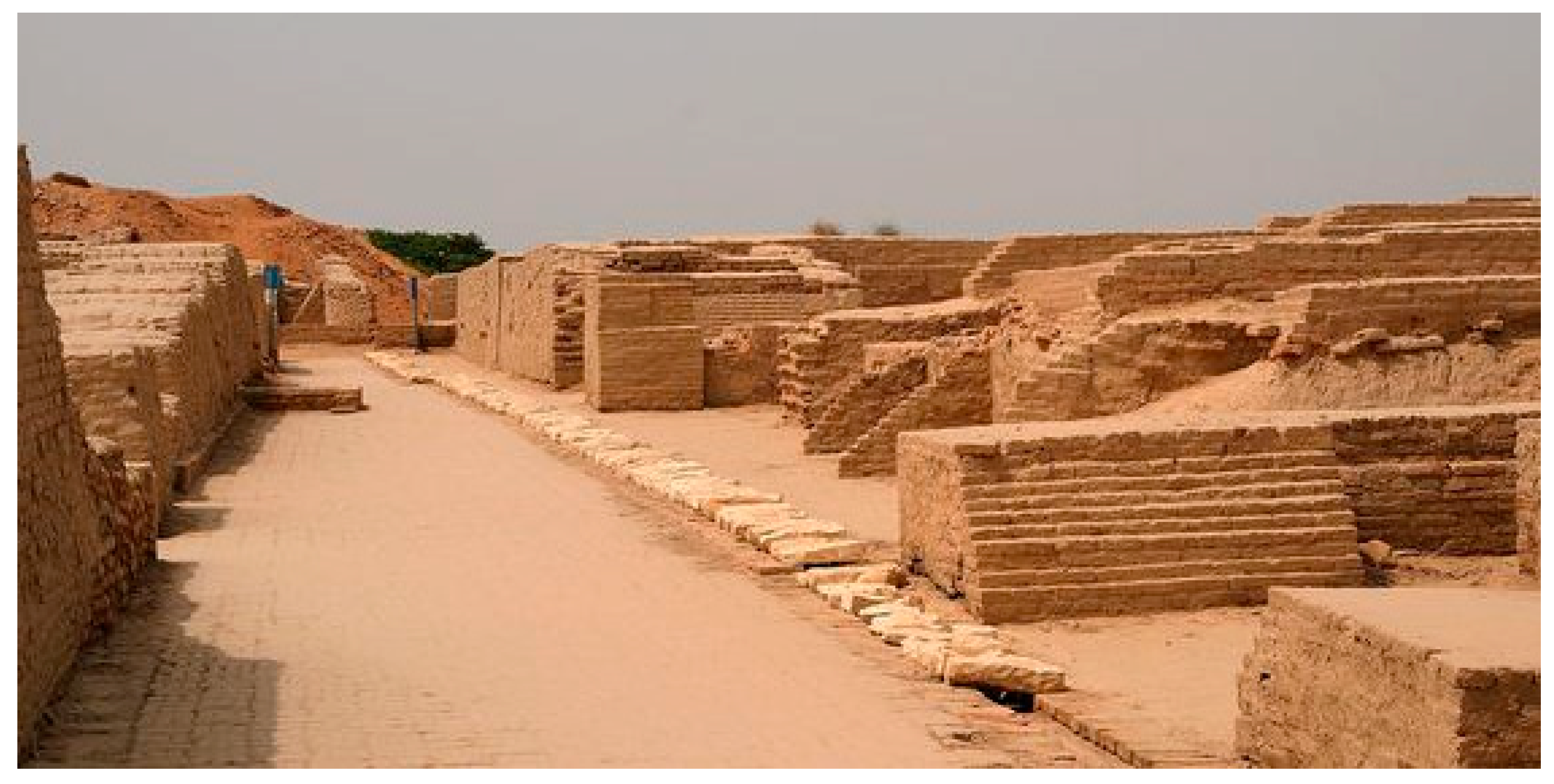
2.1.4. Indus Valley Civilizations (ca 3200–1300 BC)

During the Early Indian Civilization, the Rig Veda, one of the oldest and most important religious texts of India, describes the country as the land of the Seven Rivers. This shows that, from the earliest historical and religious documentation about India, water played a significant role in shaping its identity [37]. This reverberates in the very name of The Indus Valley Civilization, one of the oldest civilizations of the Indian subcontinent. Throughout history, seafaring and navigation were crucial to India’s economic development, with evidence suggesting that the people of the Indus Valley engaged in trade with ancient Egyptians and Mesopotamians [38].
The Harappan (or Indus Valley) civilization, which existed from around 3000–1500 BC, was one of the earliest and most advanced civilizations in the world. Known for its large spatial extent and high level of development in science and society, the civilization was particularly renowned for its obsession with water. According to Jansen [39], the citizens of the Harappan civilization prayed to the rivers every day and accorded them divine status. The urban centers of the civilization were developed with state-of-the-art civil and architectural designs, including sophisticated drainage and wastewater-management systems. Agriculture was the main economic activity of the society, and an extensive network of reservoirs, wells, and canals, along with low-cost water harvesting techniques, were developed throughout the region [40]. Moreover, modern studies suggest that the cities of Mohenjo-Daro and Dholavira had the most effective examples of the civilization’s water-management and drainage systems. The Great Bath of Mohenjo-Daro is considered to be the “earliest public water tank of the ancient world”.
The Indus Valley Civilization was located in the Indus River valley, which experienced major floods in the past, as it does now. Studies of sediment layers at the site of the ancient city of Mohenjo-Daro have revealed evidence of large floods [41]. The Indus people established a sophisticated system of canals and drainage channels to control the floods, and they built their cities on raised platforms to protect against floodwaters. Additionally, they understood the seasonal patterns of the floods and were able to plan accordingly. However, sometimes the floods could be devastating and cause damage to the cities and people. Archaeological evidence suggests that the Indus people were well aware of the seasonal rainfall and flooding of the Indus River [42]. The main streets of Mohenjo-Daro and Harappa with widths varying from 3.50 to 10.00 m, and up to 1.5 km long (Figure 5), were laid from east to west and north to south, intersecting at right angles, and served as flood protection [43]. Lanes were joined with the streets and each lane was used by the public and was provided with street lamps. Life in the Indus cities and general urban status appears to have been similar to that of the Minoans.
In addition, societies have constructed dams in Mehrgarh and Mesopotamia ever since the Neolithic times. Thereafter, throughout the Bronze Age (ca 3200–1100 BC), dams were built in southeastern Greece and the Indus Valley (e.g., the Mohenjo-Daro is an archaeological site in the province of Sindh, Pakistan, built around 2500 BC), to make the cities more adaptive to flood hazards and to improve the living standards of the people [44].

2.1.5. Babylonian, Assyrian, and Other Civilizations (ca 3500–500 BC)

The Mesopotamian Empire states (Assyria and Babylonia) marked great advances in civilization during the second millennium BC. The ruins of their cities include well-constructed storm drainage and sanitary sewer systems. For example, the ancient cities of Ur and Babylon, located in present-day Iraq, had effective drainage for stormwater control [45]. These were built as vaulted sewers, connected with drains for household waste, gutters for surface runoff collection, and flood protection [46]. The structural material was baked bricks (clay) with asphalt sealant. Mesopotamians viewed urban runoff as a nuisance and flooding concern, a waste conveyor, and a vital natural resource; therefore, rainwater was collected for household and irrigation uses. Babylonians were also motivated to construct urban drainage systems by their desire for cleanliness: like in other ancient civilizations, uncleanliness was considered a taboo, due to the moral evil it suggested [47].

2.1.6. Early Chinese Civilization (ca 2000–200 BC)

China developed as a river-based agricultural society around major rivers, in particular the Yangtze River and Yellow River. Accordingly, the evolution of Chinese civilization and state formation was closely related to the societal interaction with these major rivers. It is a fact that living at the rivers was and is a priority because of the basic need for water for agriculture. At the same time, however, the choice to develop next to rivers exposed societies to flood hazards. Therefore, river flood management has been acknowledged as vital from early history to the present age.
The mid- and downstream sequences of the Yellow River were the center of early Chinese civilization and the state-formation process. The earliest documented event of flood governance as well as the most popular folklore narrative in China is the story of Da Yu the Great’s governance of water. According to the story, at some point in Da Yu the Great’s lifetime (around 2000 BC), when the Yellow River was flooding frequently in the middle basin, which the ancestors of the Chinese inhabited, the people suffered huge distress [48]. Much effort was invested by the leaders of the local tribes in governing the flood but with no effect whatsoever. Da Yu, the son of the leader of the tribe groups, was appointed to continue governing the flood after the works of his father and ancestors failed. After a field survey in the flood areas and assessment of the previous flood-management works, he found that the previous works of flood governance failed because they had made a lot of dams and mounds in order to stop floods, but they neglected managing the water after the mounds. So he changed the idea of water governance from halting water to leading water into the East China Sea. He led people to direct water into the sea successfully; after that, future floods were effectively governed and people experienced a safe environment for life. Because of this great achievement, Da Yu the Great became the Emperor of the Xia Dynasty, the first dynasty of China. “Water has to be led and not just be stopped”; this legend of Da Yu the Great became the most important principle of Chinese water governance, but it had a profound influence on Chinese society beyond this, including the principle of flood control becoming a norm of social management for subsequent thousands of years. Accordingly, according to popular legends and early documents from around 700 BC, the first dynasty, the Xia Dynasty, emerged dealing with successful flood-management strategies and achievements [49].
China was united as a country by Qin the Frist Emperor in 221 BC. However, before the states were united, the states along the midstream and downstream of the Yellow Basin had succeeded in flood management in the Yellow River waterway and its tributaries using dyke dams. At that period, not all flooding was natural but some was artificial due to some states using water as a weapon to damage and even destroy populations, settlements, and agriculture. To avoid this disaster, states constructed large dykes and directed waterways to manage floods. Thus, dyke construction was a very early feature of flood control in the Chinese context. Concurrently, however, in this early period, sections of the Yellow River were managed separately by the states, so a consolidated inter-state dyke construction strategy was not coherent and uniform enough to be linked together. Thus, in this early period, flood water was not harvested and saved effectively. This situation changed with the establishment of the Qin Empire when the emperors’ engineers successfully linked the dykes into a coherently functioning system.

2.2. Historical Times (ca 1100 BC–476 AD)

2.2.1. The Kingdom of Kush in Egypt and Sudan (ca 1070 BC to 350 AD)

Several ancient civilizations in Africa such as the ancient city of Meroe which was the capital of the Kingdom of Kush (1070 BC to 350 AD) located in what is now modern-day Sudan, were located near the Nile river and experienced frequent flooding [50]. In the Kingdom of Kush, the population likely used various methods to combat floods. These may have included building levees and dykes along the Nile to control the flow of water and creating drainage systems to channel water away from populated areas. Additionally, the Kushite people may have also practiced flood-resistant agriculture, such as planting crops that could withstand long periods of submersion in water [51]. These strategies would have helped the population mitigate the impacts of floods and protect their communities and livelihoods.
Furthermore, the Kushites developed a type of reservoir known as a Hafir to store water for irrigation and other agricultural purposes in their kingdom (Figure 6). A Hafir is a large basin used to store water in ancient Kushite civilization, located in the Nile Valley. It was a crucial component of their agricultural system and helped in providing a consistent water source for crops, even during dry seasons. Hafirs were typically constructed with mud bricks and served as a symbol of wealth, power, and prestige for the local rulers and communities. In addition to irrigation, they were also used for fishing and sometimes served as a source of drinking water. The creation and maintenance of Hafirs required significant effort and resources, showcasing the importance placed on water management in the ancient Kushite civilization in what is now modern-day Sudan.
The ancient city of Meroe in Sudan is home to several well-preserved pyramids that date back thousands of years. However, the city and its pyramids have been threatened by recent record flooding (Figure 7). The floods, which have been fueled by heavy rains and the overflowing of the nearby Nile River, have caused significant damage to the city and its ancient structures.
The pyramids at Meroe are some of the best-preserved ancient pyramids in Africa, and they are considered to be important cultural and historical landmarks. The floods have raised concerns about the long-term stability of the pyramids, as well as the safety of the tourists and local communities who visit the site. Efforts are underway to protect the pyramids and the city of Meroe from further damage. The Sudanese government, along with local communities and international organizations, is working to build levees and other protective structures to prevent flooding and protect the ancient structures.
The recent record flooding in Meroe is a reminder of the vulnerability of ancient structures and the importance of protecting cultural heritage. The necessary measures must be taken to prevent further damage and ensure the preservation of these important landmarks for future generations.

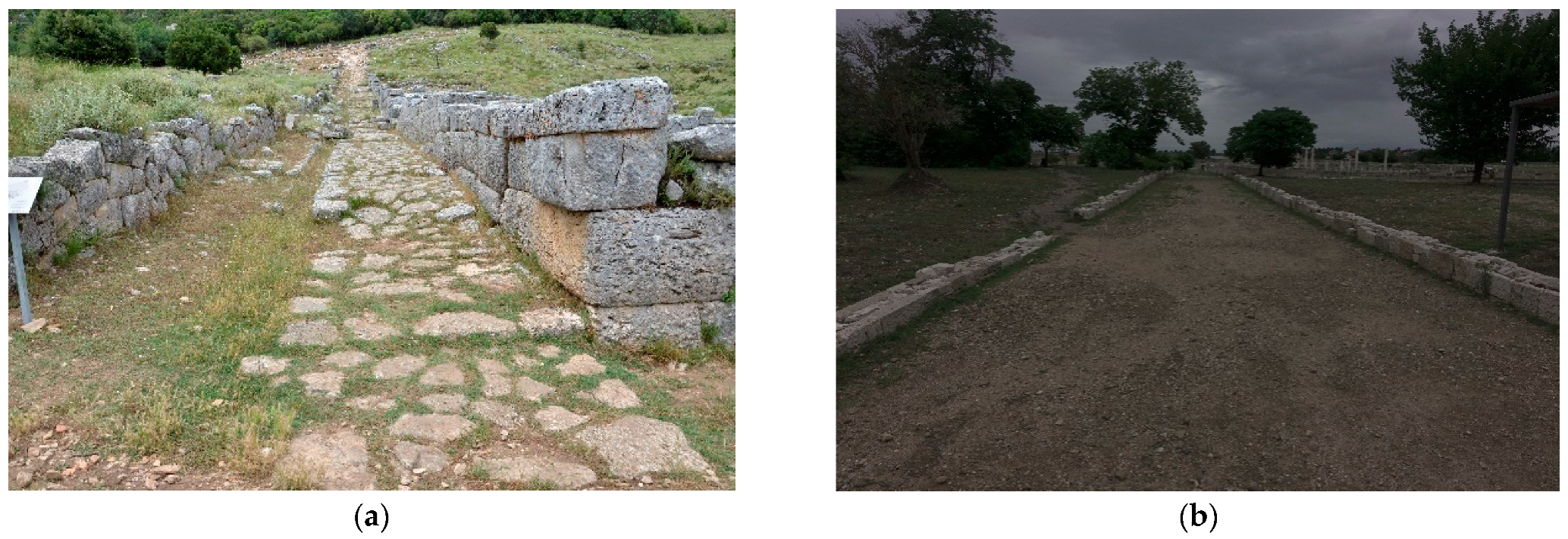
2.2.2. Archaic, Classical, Hellenistic, and Roman Periods (ca 750 BC–476 AD)

Students of the ancient Greek past and its Classical heritage are familiar with the mythological corpus allegedly confirming the cultural order between gods, men, and animals (e.g., the Prometheus myth), and myths of great deluges, including the Orgygian and Deucalion floods [28]. Situated in its mythological deep past, the destructive forces of floods swept and even destroyed Greek lands including Plato’s Atlantis, and he makes remarks in the dialogs Timaeus (22) and Critias (111a–112a) concerning how this occurrence shaped the physical outline of Attica in his day. This type of mythical construction served different purposes in the treatises of Greek and Roman antiquity, including contemplations of moral decline between past and present, and etiological purposes explaining how the physical world came to be, and how Gods and humans developed and interacted in the past.
The history of flooding in ancient Greek contexts confines strategies concerned with the protection of urban areas and in particular agricultural lands. The topography and geology of the Greek mainland and the isles of the Aegean Sea display great diversity, including mountain ranges separating smaller and large plains suitable for agriculture. Rivers cut through these landscapes, and at times currents have had a great impact on their surroundings with seasonal erosion and alluvial deposits. The hydrology of Greek landscapes, past and present, is dominated by erratic rainfall throughout seasons, with the dominant winter rain as a particularly destructive force.
Hippodamus of Miletus (498–408 BC), the Greek architect, urban planner, physician, mathematician, meteorologist, and philosopher and “the father of European urban planning” [51], was active in the context of the so-called Ionian School, in Miletus. He developed sophisticated urban planning, the so-called Hippodamian grid, which was not just the implementation of an ortho-regular road system; it was the general and physical organization of a city to serve its functions in a rational way, including infrastructure to protect cities from floods [52]. His planning method was first applied to Miletus, then to Kassope (Cassope), Olynthus, Pella, Piraeus, Priene, Rhodes, Alexandria in Egypt, and other places [28].
According to the Hippodamian grid plan, the streets were 9 to 10 m wide, except for the main east–west artery, which was up to 15 m wide (Figure 6a,b). Drainage and sewerage were built under the pediments (not preserved) as shown in the images of Pella (the capital of Macedonia founded by King Archelaus I around 400 BC) and Kassope (an ancient Greek city in Epirus), respectively [28] (Figure 8).
Another important example of flood control works is the Alyzia dam, in western Greece. The city of Alyzia was located on the coastline of Akarnania. Close to it, on the fringes of the Acarnanian Mountains, lies a unique example of ancient hydraulic structures constructed during the fifth century BC. The arrangement includes a stone dam, equipped with a stone-carved lateral spillway (Figure 9), in which the bottom part is characterized by squared blocks, irregularly placed, with smaller blocks filling the gaps between them. In the upper zone, where the slope becomes milder, stones are uniformly shaped, and regularly positioned with smaller gaps, which did not require filling with smaller stones. The structure impresses the observer with its overall technological and constructional quality. According to Murray [53]: This “is the clearest, largest, and most technologically advanced ancient specimen yet known in the whole country”.
Construction of such a structure certainly required considerable effort by the city. Various hypotheses have been advanced about the reasons that led to its erection. Most conclude that the dam was built to collect drinking, irrigation, or “industrial” use water (for washing sheep wool). Another study [54] advanced a different scenario, submitting that floods in the Alyzia valley were exceptionally intense, leading to serious problems in urban and suburban areas. To mitigate floods and retain the coarse sediment that inundated the valley, the people of Alyzia constructed the dam in the most suitable location along the river. Even today, this solution could be one of the most effective for flood and sedimentation control [28]. The current condition of the dam is excellent: stones are still in place and only slightly smoothed, giving the clue that the spillway has always operated effectively for over 2500 years.
The extant evidence from the Classical period (ca 500–300 BC) demonstrates that farmers were particularly observant of the destructive force of erratic rain causing serious damage to property including agricultural lands, livestock, and crops. The peninsula of Attica with its major urban areas of Athens proper and the Piraeus expanded greatly during the fifth century, and in this process added much-needed hydraulic infrastructure including measures against torrential rain and its destructive abilities [34]. In the Attic countryside, moreover, erratic rainfall caused damage to the road system and triggered legal disputes between neighbors. In a forensic speech by Demosthenes (Against Callisthenes, no. 55) the accused defended himself against the plaintiff’s (Callisthenes) accusations of damming a watercourse with a wall alongside the road between the two estates in question. Thus, allegedly, during a storm water flooded the land and the estate of Callisthenes and caused damage to land and some barley and wheat flour. The details of the case leave the impression that the estates were located in a hilly country, and this type of land naturally called for measures to control the changeable patterns of precipitation of Attica. The settlement history of the peninsula points in the same direction. In the territory of the southernmost deme (local administrative entity) Atene, German archaeologists conducted in the 1980s an intensive survey and identified several outlaying farmsteads with adjacent agricultural terraces [55]. Together with terrace walls, the survey team observed several constructions, aimed at directing torrential water through or around the terraces to prevent damage. In addition, and as a possible side effect, these constructed watercourses drained water amassed in the soil behind the agricultural terrace walls and thus prevented their collapse. The possible amassment of water in basins at some of the constructed watercourses even suggests that the drainage and control of precipitation and irrigation constituted the double effect of water management in hilly agricultural land [56].
Ostensibly, the same strategy lies behind the outlines of a grand-scale drainage project of Lake Ptechae adjacent to the ancient city of Eretria on the island of Evia (Euboea) (Walker 2004 on Eretria, Krasilnikoff 2010 on the drainage project, and Krasilnikoff and Angelakis 2019 on the judicial aspects of the project) [26,57,58]. The inscription (IG XII.9.191A) from around 320 BC specifying the agreement states that the entrepreneur Chairephanes was hired to perform the construction and lists details concerning the project. It is uncertain whether the drainage facilities were ever built, but it is of some importance to acknowledge that the Eretrians contemplated water-management projects of significant scale. Presumably, the double irrigation–drainage function of the project may have assisted in preventing massive winter rain from causing damage to land and communities in its surroundings.
Inscriptions from the Classical city-state of Gortyn display the endemic challenge of flooding agricultural land. In Gortyn as in Attica, control of water agricultural land in the hilly country posed a challenge to farmers. Extant laws from the Classical period (ca 500–300 BC) display the keen civic interest in law-making preventing the negative effects of torrential rain and instructing farmers not to lead off water through the land of neighbors (IC IV 73 A, IC IV 52 A and 52 B, 1–6).
The successor of Aristotle as head of the Peripatetic school at Athens, Theophrastus, speculated that the climate of the island of Crete was variable: “But if, then, it is true what others, especially those (living) in Crete, say, that now the winters are longer and more snow falls, presenting as proof the fact that the mountains once had been inhabited and bore crops, both grain and fruit-tree, the land having been planted and cultivated. For there are vast plains among the Idaean mountain and others, none of which are farmed now because they do not bear (crops). But once, as was said, they were settled, for which reason indeed the island was full of people, as heavy rain occurred at that time, whereas much snow and wintery weather did not occur” [59].

2.2.3. Indian Historical Times (ca 1100 BC–476 AD)

The Mauryan Empire in India (322–185 BC) was known for its advanced hydraulic civilization, as evidenced by structures at the locations of Pynes and Ahars (irrigation and water-management system) and the Sudarshan Lake reservoir at Girnar. The water-management structures of the Mauryans suggest a thorough understanding of dam and reservoir construction, water channeling, and hydrological processes. Moreover, water pricing was also an integral part of their water-management system [60].
The manuscript of Arthashastra, attributed to Kautilya, who was reportedly the chief minister to Emperor Chandragupta (ca 300 BC), the founder of the Mauryan dynasty, deals with several issues of governance, including water governance. It mentions a manually operated cooling device called “Variyantra” (a revolving water spray for cooling the air) and provides an extensive account of hydraulic structures built for irrigation and other purposes during the Mauryan empire [61].
Floods have been a recurring natural disaster in India’s history, particularly in riverine areas. Flood frequency and severity likely varied depending on factors such as climate variability and human land-use practices during the Prehistoric Era. Although historical records from this period are scarce, accounts of significant floods can be found in texts such as the Vedas, Puranas, and medieval chronicles.
Floods are mentioned in several ancient Indian texts, such as the Shastri and Tagare [62] in the Vedas and the Puranas. The Vedas, which are some of the oldest sacred texts of Hinduism, contain references to natural disasters, including floods. For example, the Rigveda describes a great flood that submerged the earth and destroyed all forms of life [63]. The Puranas, which are later texts that contain stories about the gods and goddesses of Hinduism, also describe floods and their devastating effects. For example, the Matsya Purana describes a great flood that was sent by the god Vishnu to destroy a world overrun by evil. The story of the great flood, in which the god Vishnu takes the form of a fish to save the first man, Manu, and the seed of all living creatures from the flood, is also found in the Vedas and the Puranas [62].
The ancient Indian epic Mahabharata, presumably composed sometime between 400 BC and 400 AD, describes a devastating flood that occurred during the Kurukshetra War. The text describes the flooding of the entire world, with only a few survivors remaining [64].

2.2.4. Roman Period (31 BC–476 AD)

The history of flooding in Rome can be traced back to the myth of the city’s foundation when Romulus built his city on Palatine Hill. Like many other ancient cities, Rome was established near a river (the Tiber), providing easy access in and out of it and, at the same time, defense from enemies. Rome gradually expanded to encompass the famous “seven hills”, overlooking the marshy floodplains adjacent to the river, which was well protected from water surges. It is thought that floodplains were not occupied by residential buildings during ancient times, save for a few establishments dedicated to agriculture or trading [65]. Starting as far back as ca the sixth century BC, the Tiber was altered by engineering projects, with canals draining the marshes and diverting the flow of nearby streams into the main course [66]. These projects allowed the development of settlements in the low-lying areas below the seven hills. One such area became the famous Roman Forum; the canal that drained it was eventually covered, becoming the Cloaca Maxima, the main drainage and sewage system of ancient Rome, critical for draining floodwater from the low-lying Forum and adjacent areas. The Cloaca Maxima also connected drainage systems of nearby bathhouses, public toilets, and street drains, diverting all water and wastewater into the Tiber in a large outfall that can still be seen today. However, the Cloaca was not a perfect drainage system, and floodwater from the river sometimes back-flowed into the city through it during floods of the Tiber. At a river height above 15.7 m asl, the cloaca would be completely submerged: the Cloaca Maxima thus differentiated the severity of floods in Rome, with major floods occurring with river levels above 16 m asl, and minor local floods occurring at levels below 16 m.
Due to its location, over the course of centuries, Rome was subjected to many flood events: in total, 33 recorded floods occurred in ancient Rome, in the period 414 BC to 398 AD [66], although records are relatively vague and do not mention high water marks or damage caused. This lack of information may suggest that Romans could have been relatively indifferent towards the effects of the floods, as most of them lived in the hills: archaeological evidence on building distribution indicates that the majority of public and commercial buildings were located in the river floodplains, while most private homes were established in the hills above, and thus would be left untouched by a flood [66].
To develop flood protection, engineers first had to understand how floods formed in Rome: they are mostly caused by rain during the winter. Due to the watershed’s soil properties, composed of relatively impermeable fine particles of volcanic ash, flood conditions in Rome build up through gradual soil saturation by prolonged rain. Finally the ground can become saturated very quickly. Floods will usually occur after about 90 days of low but consistent rainfall, followed by more intense events that will then produce large volumes of surface runoff, carried by the river. Consequently, Roman engineers developed plans and structures to protect the city: an important measure for preventing floods was to build high embankments along the river; however, these were often not successful due to insufficient height. Records show that to control floods Marcus Vipsanius Agrippa, one of the most influential architects/engineers of the Roman Empire, and curator of public works under Emperor Augustus implemented programs to keep the riverbed clear of debris, erect embankments, and improve flow conditions within the Cloaca Maxima. Due to the frequent floodings, deposited sediment and debris naturally raised the level of the city, making it more resistant to future floods. In addition, the elevation of some lower areas, most notably the Roman Forum, was artificially raised: during excavations, it was discovered that, in some sections, ancient buildings sit on top of up to eight layers of man-made debris [66].
The Romans developed centuriation in Italy and over all the Empire and traces of the work are still visible today, larger or smaller according to circumstances. Centuriation entailed a division of a territory into geometrical figures, as regular as possible and of equal size, the building of infrastructures (roads, canals for drainage, and sometimes canals for irrigation), and the assignment of single plots [67].
The development of centuriation had the following aims: (a) settling a loyal and stable population; (b) guaranteeing water drainage from a flat terrain towards the natural outlets; (c) increasing agricultural production; and (d) improving the living conditions of local settlers. Roman centuriation affected many hectares all over Italy and in other areas of the Empire (France, Spain, England, Belgium, Holland, Germany, Switzerland, Dalmatia, Greece, and North Africa) mostly in the plains. It usually led to radical hydraulic improvement of the territory. The orientation of this parceling was designed to control rainwater and discharge from surface water tables, so as to prevent flooding and return to marshland [67].

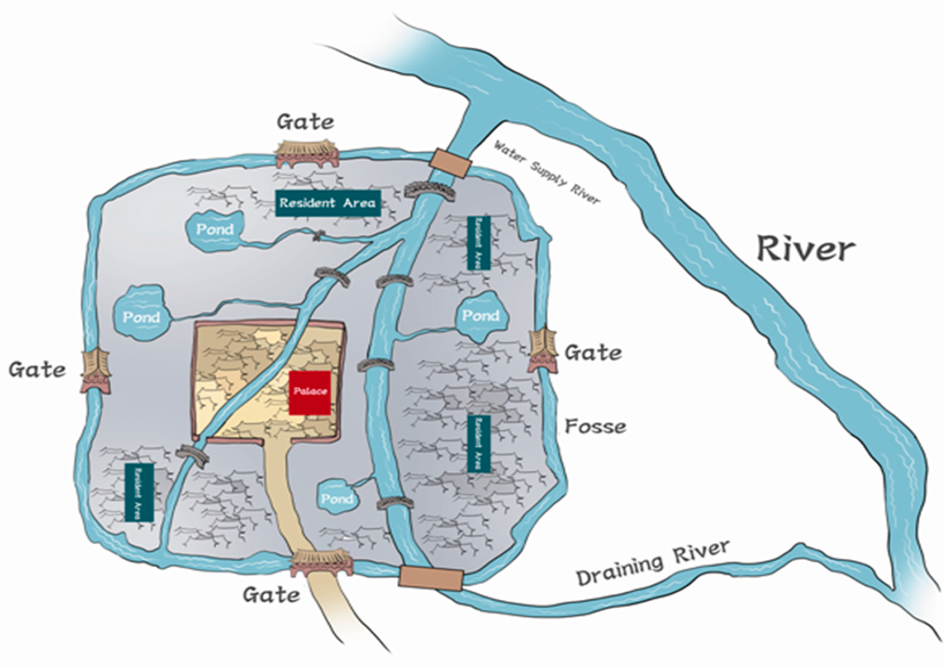
2.2.5. Chinese Han Dynasties (ca 202 BC–220 AD)

The Emperors of the Han Dynasty were powerful and resourceful agents of societal development and prompted a particularly flourishing period in Chinese history. This included significant contributions to the development of water management and flood management. The Han Dynasty ruled in two separate chronological and geographical settings, the West Han (202 BC–8 AD) and East Han (25–220 AD). In this period, flooding frequently occurred in the mid- and downstream basin of the Yellow River; it covered the economic, social, and politic centers of the empire. Largescale floods are recorded 16 times in the official historical book “The Han Book”. The Yellow River changed its riverway, at times in history even connected with the riverway of Huai River, another big river in China. The change in the riverway of the Yellow River was an important cause of flooding. Flooding often imposed massive loss of lives on local populations, and considerable tracts of farmland and settlements were damaged or destroyed as well. Consequently, as an example, due to the flooding in 29 BC in the location of the crevasse at the Yellow River in the Dong-Jin prefecture, 9700 people were forced to leave their homeland [48].
Depending on the situation regarding the level of water in the river, restoration and strengthening of the dyke of the Yellow River became an important governmental affair of central and local administrations, and especially in and after Emperor Han Wu’s reign, flood management was practiced on a large scale. Year after year, thousands of laborers were forced to restore the crevasse and strengthen dykes. On the technical level, watercourse management was executed using heightening dykes with earth and stone to stop water from spilling over. The crevasse was blocked off using reinforcing with wood, bamboo, and filling stone and earth. Thus, flood control of the Yellow River was effectively managed by hard efforts. At the same time, however, the level of the riverbed was increased above the ground due to the deposition of huge sediment and continually rising riverbanks to prevent flood; this caused the river to dry up. This situation caused most sections of the mid- and downstream sections of the Yellow River to flow above ground level.
The Han Dynasty was not just effective in achieving flood management of the Yellow River, but excelled in urban water management as well, especially regarding urban flood management. The Han Dynasty’s capital was Chang’an city, near today’s Xi’an city, Shanxi Province [45]. According to historical documents, from its very beginning, this capital city was envisioned to be very large and remained so for 15 dynasties until 907 AD. Chang’an city extended over 35 km2 and supported a population of 500,000 people [68,69]. Archeological studies suggest that a complex water system including a drainage system was built in the city to support water supply, drainage, storage of water and transportation of ships (Figure 10). The city was founded at the south side of Wei Shui (渭水) River, but the water supply was connected to the Jue Shui (泬水) River from the south of the city, which flowed into the city from the north. Similarly, it flowed across the palaces and the part of the city called the Ming Ditch (9 km in length), and finally connected with the Wei Shui River on the other side of the city. The other branch of the Jue Shui River also flows across parts of the town and then into the Wei Shui River. As a water system, a series of hydraulic engineering items were built to accomplish separate functions. For example, large ponds were built for sluice, and the most famous one, which still exists today, is called Kunming Pond. This pond performs the functions of rainwater sluice in the summer, and water storage and supply in winter. Outside the town, a fosse (length of 26 km) was built around the town, connecting with the city river, Ming Ditch, and it also performs the function of storage of rainwater from the town [69,70]. The water systems were connected to water supply rivers, ponds, drainage sluiceways, fosses, and drainage rivers. However, rainwater and waste water gathered via underground sewers and channels from the palaces and resident places of the city were led into the main system, and later into the Wei Shui River via the Jue River, which comprises a perfect urban drainage system.
The impact of the water system of Han Chang’an city reached beyond the site itself and created a model of the urban drainage system and design for major cities in the centuries to follow. The logic of the model was that a city usually built a fosse circumscribing the town wall, with one or more canals across the city and some ponds, which were constructed as the main structure of the water system. Finally, the construction and connection of drainage channels with underground sewers, pipelines, channels, etc., from residential areas of the city were also achieved. Hence, when the rainwater or wastewater was gathered, it was directed into the main system via the subsystem and stored in the ponds or in the fosse. Outside the city, normally, a canal was built to facilitate water for the city’s water supply, and another channel connected the fosse and the river in the lower reaches of the river for drainage. With this function, wastewater was usually cleansed in the ponds and the fosse, and when stormwater came, it was channeled into the ponds and the fosse, and later into the river. Therefore, flooding could be effectively stopped via this system, and additionally, the system supported storage of water to be used during the dry season [69].

2.2.6. Byukgolje, the Largest Man-Made Reservoir in Old Korea, Baekje Dynasty (ca 18 BC–660 AD)

Because Korea is located in the Monsoon region, flooding and drought can occur in the same year. To make things worse, since 65% of the country is a mountainous area, rainwater flows down with high force, making rainwater management a big concern for the government. A common solution has been to build reservoirs to collect rainwater during the summer and use it for spring.
In the southern part of the Korean peninsula, ruins of an earthen bank and stone gates can be seen in Kimje city, which means “the bank that makes money”. It was completed in ca 330 AD under King Biryu of the Baekje Dynasty. Its length was 3.3 km with a trapezoidal cross-section of a height of 4.3 m, a bottom length of 17.5 m, and a top length of 7.5 m; three stone gates were built to divert water in the direction of other cities. The area of the reservoir was 34.5 km2 with a circumference of 68.8 km, which made it the largest man-made reservoir in the world at the time, with the function of collecting rainwater and using it for mitigation of both floods and droughts.
The same construction technology was adopted in Japan to construct the Sayama-Ike reservoir in 616 AD. The area of the reservoir, still standing, is 0.36 km2, with a circumference of 3 km, bank length of 730 m, and height of 18.5 m. Both Kimje City in Korea and Sayama City in Japan are trying to list their ancient reservoir construction technologies with UNESCO world cultural heritage.

2.2.7. Byzantine Period (ca 330–1453 AD)

According to historical records, several natural catastrophes occurred in the Byzantine period, with towns being destroyed by natural calamities, including floods and tsunamis. The Byzantine Empire endured severe weather conditions, a plague, a large flood, two tsunamis, and three significant earthquakes during the reign of Justinian I, earthquakes being by far the most frequent calamity due to the empire’s location between Anatolia and the Mediterranean, a highly seismic area [71,72]. According to the Chronicle of John Malalas, the Daisan (Skirtos) River, a tributary of the Euphrates, in Southeast Asia Minor, suddenly flooded in 525 AD, and within a few hours, the flood submerged the entire city of Urfa. Because the city was walled, the flood turned it into a lake until water pressure caused the walls to collapse, releasing it to the plains outside [72]. Leo the Deacon wrote about an exceptional storm in Istanbul (formerly known as Constantinople) during June of 967 AD: this was unlike any other storm that had ever occurred. Overflowing rivers invaded the city’s narrow streets during three hours of continuous rain, destroying anything they encountered (Deacon). Moreover, during the Second Crusade, 7 and 8 September 1147, records report that the German camp was flooded and destroyed [73,74].

2.2.8. Medieval Times (ca 476–1400 AD)

The flooding of the Tigris and Euphrates Rivers in Mesopotamia in 628 AD was probably one of the main reasons for the fall of the Sassanid dynasty. Blazeri, the Islamic historian, attributes the end of the reign of Khosrow Parviz to the occurrence of this great flood. The event led to the death of many people, the destruction of crops, famine, displacement, and the spread of the plague [17].
The Turkish Seljuk Empire was established as a result of increased Turkish immigration to Anatolia following the Battle of Manzikert on 26 August 1071. In a short period, the Empire, which dominated Anatolia’s geography, attained political independence. Like most other states, it experienced diseases and natural disasters. Even though the historical sources of the time do not accurately reflect the losses incurred as a result of these disasters, it is not difficult to assume that a significant number of lives were lost and that the Empire was seriously challenged as a result. The first disaster recorded in that period was the flood of the Euphrates River: in 1079/80, the river flooded as a result of heavy rain, and the water climbed 6.12 m [75]. Later, on 19 May 1165, due to the torrential rains in Meyyafarikin, a flood was able to transport downed trees and grazing animals away; Ibnü’l-Ezrak indicates that the catastrophe also claimed the lives of 160 persons (İbnü’l-Ezrak). A series of violent storms and floods struck the Cilicia region in 1154, forcing the Turkish Seljuk Sultan Mesut to postpone his campaign against the Armenians [76].
The city of Antakya experienced a disastrous flood in May 1178 as a result of heavy rain. According to Syriac Mikhail, “In May 1178, a great rain poured in Antakya. The city was completely devastated. The flood’s impact was so significant that it exceeded the height of the walls” [77]. The Sudak Expedition, in 1227 during the reign of Alaeddin Keykubad, had the objective of capturing the city of Trabzon, but everything went awry due to a storm and torrential rain right before the city was to be conquered: due to flooding, the Seljuk army was forced to retreat. As a result, the siege of Trabzon was unsuccessful [78].
A significant flood occurred in 1244–1245, during the reign of Gyâseddin Keyhüsrev II, when the Berdan Stream, which passed close to Tarsus, surged. The bog that was created prevented the Seljuk force from moving [76,78]. The city of Amasya experienced a flood on 15 March 1290, which left behind significant damage, largely devastating the city. In Niksar (Tokat), half of the city was damaged as a result of intense rains and numerous lives were lost as a result of the flood calamity [77].

2.2.9. India during Medieval Times (ca 476–1400 AD)

Water management in medieval India was an important aspect of society, as the agricultural economy relied heavily on irrigation. The rulers of the time recognized the importance of proper water management and implemented various systems and techniques to ensure an adequate water supply for crops.
One of the most notable examples of water management in medieval India is the construction of tanks, reservoirs, and canals. These structures were built to store and distribute water for irrigation and were often financed and built by the ruling monarchs [79]. Another important aspect of water management in medieval India was the development of water-lifting devices, such as the Persian wheel and the chain pump. These devices were used to lift water from a lower level to a higher level, allowing for the irrigation of fields on higher ground.
Medieval Indian rulers also implemented regulations and laws to ensure the fair distribution and use of water resources. In addition to these technological and organizational aspects, water management in medieval India also had a spiritual and religious dimension. Many temples and religious institutions were built near water sources, and rituals and ceremonies were performed to ensure the continued flow of water [80].
Floods were a common occurrence in medieval India as well. The monsoons, which bring heavy rainfall to the Indian subcontinent, were the main cause of floods. The floods would often cause significant damage to crops and infrastructure, and could also lead to loss of life [81]. In addition, many rulers and local leaders built dams and embankments to protect their territories from floods. There are many references to these efforts in historical texts and inscriptions [82].

3. Floods in Early and Mid-Modern Times (ca 1400–1850 AD)

The earlier European Renaissance brought a change to the way flood records were kept: around the 13th century, markers started to be used to record the highest flood water levels after a nearly 400-year gap in any sort of reliable record keeping. The accuracy of these markers was also improved in two ways. First, the number of markers being placed throughout the city was increased; second, the measured height became more accurate thanks to the installation of hydrometers along the river banks. The Ripetta Wharf hydrometer quickly became the standard reference for all floods’ high water marks, with records kept to the centimeter [66].
The early techniques used by Romans to prevent flooding fell into oblivion during the Medieval Period. In Rome, natural and manmade debris built up in the Tiber drains clogged the system, and several aqueducts, in which residual waters were used to flush sewers after use, fell into disuse. The buildup of debris in the river raised the riverbed level, slowing the flow and making floods both more common and devastating. The four worst floods recorded in Rome’s history occurred during or around the 16th century, with the high flood levels over the 18 m asl mark in 1530, 1557, 1598, and 1606. During the worst flood of 1598, water submerged the first story of most buildings in low areas, and buildings in the Jewish ghetto (the lowest point of the city) were submerged up to the third floor [62]. For the Catholic Church that governed the city, the floods were an embarrassment, as they destroyed many religious buildings and their contents; therefore, in the aftermath of the 1557 flood, the Church entrusted Andrea Bacci, a physician, and Antonio Trevisi, a military engineer, to come up with a flood-control plan [83]. Both believed that floods had been less severe in ancient times because the river and urban drains were kept clear of the debris that had caused the rising of the riverbed and the reduction of outflow from the urban stretch of its course. Therefore, they recommended returning to the methods of the ancient Romans, which mainly included dredging the river, providing more water to the city, keeping drains clean, and appointing a government official to supervise river works [83]. The construction of trenches between the Vatican and the low-lying Trastevere area was also recommended to help prevent local flooding; however, the only portion that was fully implemented was the one that nowadays forms the moat around Castel Sant’ Angelo. Subsequent records show that flood levels have never reached the levels of the 16th century, meaning that the recommended flood control measures have been somewhat successful.
A major turning point in response to floods in Rome dates to 1870: on 27 December, waters reached a high water mark of 17.27 m. Such a high water mark was an extreme anomaly compared to the floods of the time, the highest seen since the 16th century’s record-breaking ones [66]. Taking after other European cities of the time, higher embankment walls were built along the River, reaching a height of 18 m, higher than all the flood levels seen since the 16th century. Completed in 1910, the new embankments were the most successful flood control measure for the city, since Rome has been subject to only three major floods since, the last occurring in 1937, which did not cause any significant damage [66].
During its existence, the Ottoman Empire had to deal not only with political, social, and administrative problems but also with natural disasters. The disasters of the period included locust invasions, earthquakes, floods, famines, and droughts, which occurred at various times throughout the country, claiming lives as well as destroying property [84,85]. There are not many detailed records of such disasters, but some major flood events were well described. Beyşehir Lake overflowed sometimes as a result of intermittent rains that occurred between 1501 and 1504, turning the Konya Plain into a sea [86]. On 24 August 1553, the 14th night of Ramadan, heavy rains during harvest time destroyed villages and fields in Kâğıthane; the damage was considerable. The force of the flood swept away trees and carts and flooded the coastal neighborhoods of Galata [87]. On September 19, 1563, during a rain that lasted for days, lightning hit 74 times and flooding wreaked havoc on the coastlines of the Golden Horn, the Galata district’s slopes, Halkalı, Silivri, Küçükçekmece, and Büyükçekmece. Most of Constantinople was severely affected by the flood, many buildings were damaged, including the Eyüp Sultan Mausoleum, which was entirely inundated, as a result of the Kâğıthane Creek bursting its banks and the Golden Horn’s water levels rising. The İskender Çelebi palace was severely damaged in its foundations by the extreme floods of the Halkalı stream [88].
One of the most significant floods in Turkey occurred in 1571: flooding caused damage to Edirne, with the Palace and other significant buildings submerged. The villages of İlbeği-Bergos, Yund-Bergos, Hatibköyü, Umurbey, Şahinci, İneoğlu, Ahurköy, Karacaköy, Kiliseköy, and Saray were impacted by the water disaster in Edirne in 1688–1689 [89]. In October 1789, there was flooding in Constantinople, Eyüp, Kasımpaşa, Galata, the Bosphorus, and Üsküdar. Markets were wrecked, dwellings and public baths were ruined, and the Mahmutpaşa and Kasımpaşa courthouses were submerged. The floods claimed the lives of around 60 people. Trees hundreds of years old and various debris items were dispersed all over the sea’s surface [90].
Severe damage was caused by a storm that hit Constatinople on 8 July 1808, with intense rain that lasted for fifty hours and damaged several buildings in the city and along the Bosphorus [91]. The Water Board-built Göksu Dam was destroyed by a prolonged nighttime downpour at the end of September 1911: two bridges and lumber-storage facilities were destroyed and 45 persons had to be rescued from the water [92].
One of the most notable floods that occurred during this period in India is the Calcutta flood. The city of Calcutta (now Kolkata) experienced a devastating flood in 1737 that killed over 300,000 people. The disaster affected the entire city and surrounding areas, causing widespread damage to homes and infrastructure and loss of life [93].
Moreover, in 1843 Egypt began construction of modern water infrastructure on the Nile, e.g., barrages to raise water levels for irrigation during low-water periods. In 1960, the high dam of Aswan was constructed in the southern part of Egypt. Since then, flooding has been stopped and the waters directed into the artificial reservoir of Nasser Lake.

Chinese Mid-Modern Times

Throughout Chinese history, flooding has been one of the most significant types of disasters afflicting populations, land and socio-economic developments. Due to its vast territory, different parts of ancient China often suffered from floods and droughts at the same time. Usually, great droughts occurred in the north and massive floods occurred in the south. However, the Yellow River, which is located in North China, often experienced flooding, with devastating effects on local settlements. According to incomplete statistics, during the 482 years from 1368 AD to 1850 AD, the Yellow River burst 267 times, with an interval of fewer than 1.8 years [94,95].
Frequent floods have caused significant loss of personnel and property. To prevent floods, the government of the Ming Dynasty (1368 AD–1644 AD) invested many human, material and financial resources in river management and storage. However, on the one hand, a sharp increase in population led to a deterioration in human–land relations and aggravated the effects of the Yellow River’s flooding. On the other hand, to maintain the smooth water transport of the Beijing–Hangzhou Grand Canal, the Ming Dynasty and the Qing Dynasty (1644–1912 AD), with its capital of Beijing, took many measures to control the flooding of the Yellow River. This took place “from the point of not interfering with the water transport”, which was very unfavorable to flood discharge and drainage [96].
The Beijing–Hangzhou Grand Canal is the longest and largest ancient canal in the world. It undertakes the important task of transporting materials from all parts of the world to Beijing. Each year, the amount of grain transported by water totals up to 200,000 tons. The canal flows south–north and intersects with the Huaihe River and the Yellow River, respectively. Once the Yellow River overflows, the riverbed rises, the sediment silts up, and the water transport is interrupted. Therefore, the Ming Dynasty government always took ensuring the smooth flow of the Grand Canal as the fundamental policy of harnessing the Yellow River. For this reason it adopted the strategy of “blocking the north and dredging the south” and “diverting water to control water potential”. The former refers to strengthening the dyke on the north bank of the Yellow River to guide the flood of the Yellow River to the south. The latter refers to the excavation of new watercourses on the south bank of the Yellow River to guide the diversion of water from the Yellow River to the south bank. The more new watercourses were excavated, the stronger the diversion capacity would be, and the smaller the threat of flood to the canal would be. As the Yellow River carries 1.6 billion tons of sediment every year, the average annual deposition of sediment in the lower reaches of the Yellow River is up to 400 million tons, which constantly raises the riverbed, blocks the river channel, and very easily floods and even bursts in cases of large floods. From the first year of emperor Ming Wuzong (1506 AD) to the seventeenth year of emperor Chongzhen (1644 AD), there were 53 years recorded of the Yellow River breach in the history books [97].
Faced with this serious situation, Pan Jixun, an official and water conservancy expert in the middle of the Ming Dynasty, was appointed as the minister of river management. He linked the governance of the Yellow River, the Beijing–Hangzhou Grand Canal, and the Huaihe River and carried out unified consideration and planning. More importantly, Pan Jixun invented the “water and sand flushing method”. The engineering and hydraulic principles of this method are as follows: the faster the river flows, the stronger the sediment-carrying capacity of the water. Dyke works can dynamically change the flow pattern. The water of the Yellow River has a large sediment content. The purpose of dredging and flood control can be achieved by building embankments or other structures on the wide and shallow river courses. This may tighten the river course, increase the flow rate, and use the impact of water to impact the sediment at the bottom of the river bed.
Under the guidance of this theory, Pan Jixun summarized the experience of embankment construction at that time and overhauled the river embankment. He thus formed a double embankment system consisting of a remote embankment with a water-blocking potential and a wisp embankment with a water flow restriction. Under his auspices, the embankments on both banks of the Yellow River and the Huaihe River below Zhengzhou were comprehensively repaired and improved, making the river channel stable. Pan Jixun paid special attention to the quality of embankment construction, put forward the principle of “true earth without mixed floating sand, high and thick with huge expense” and “cone by cone exploration of earth embankment”, and strengthened the embankment management and protection work. After the actions taken by Pan Jixun, the problem of the Yellow River flooding had been solved for a long period. According to the historical records, “The high weir was built at the beginning, and the river was smooth after clearing the mouth. It lasted for several years and there was no major disaster in the river” [98].
Pan Jixun’s work of harnessing the Yellow River was limited to the lower reaches of the Yellow River, and the middle reaches where the sediment comes from had not been controlled. The continuous sediment cannot be transported to the sea, and some sediment must be deposited in the downstream river. So until the Qing Dynasty, although there was also a capable river governor such as Jin Fu who used the method of “bundling water and attacking sand” to control the Yellow River, and achieved certain results, the problem of the Yellow River flooding was not completely solved. With the corruption of officials, some Chinese scholars have commented that “the floods and droughts caused by these human factors and the losses caused by them are more than the impact of geographical conditions” [99].

4. Floods in Contemporary Times (1850 AD–Present)

One of the most common natural disasters that affect people worldwide is flooding. The average number of disasters caused by weather and the environment has increased by around 35% during the past three decades [100]. Extreme weather and climate-related events alone accounted for 83 % of all disasters over the past ten years, resulting in 410,000 fatalities and 1.7 billion people affected [4].
As in the past, modern-day flood occurrences remain a constant threat and a main global natural disaster event, with an increasing number of locations facing increased flood risk. It is, however, a fact that driving factors differ and the features of modern-day floods may be very different from early history and data indicate that local conditions cause unique occurrences. Thus, accordingly, we survey them case by case.
In general, the ultimate measure of the risk involved and the threat posed is the number of deaths from natural disasters. Natural disasters kill an average of 45,000 people a year worldwide. In the last ten years, disasters accounted for 0.1% of deaths worldwide. The variation was wide, ranging from 0.01% to 0.4%. The number of deaths caused by natural disasters has declined sharply over the last century, from millions of deaths per year in some years to an average of 60,000 in the last decade. Disasters hit the poor hardest, with most deaths occurring in low- to middle-income countries that lack the infrastructure to protect themselves and respond to events. In the past, droughts and floods were the deadliest disaster events. Today, the death toll from these events is very low—the deadliest events today tend to be earthquakes [101].
Relevant data are shown in Figure 11 for all natural disasters classified into five categories, including floods and the other two hydroclimatic types.
The impacts of hydroclimatic disasters, including floods, have dropped since the beginning of the 20th century; victims of these types of disasters have diminished, while other natural disasters still cause large numbers of casualties. In the 2010s, the primary cause of casualties was earthquakes, representing 59% of the total number of victims. In 2020, floods caused the death of more than 6000 people across the globe, but this death toll is dwarfed in comparison to the peak recorded in 1999 when some 35,000 people died [103]. The reason behind these statistics is not that floods and droughts have become less severe or less frequent; rather, the improvement of technology, risk assessment, management, and mitigation, along with the strengthening of international cooperation, contributed to this effect [102].
The total number of victims from natural disasters, mainly due to floods and earthquakes, in the last 20 years is 30,000/year worldwide, with a slight downward trend, much less in the developed world than in the developing one. Moreover, taking into account the global population increase, deaths due to those causes have decreased significantly in recent years. Losses from other causes, such as traffic accidents, appear to be about 30 times higher than from natural disasters [88]. According to data from 2010–2017, deaths from natural disasters represent 0.08% of the total number of deaths, as seen in Figure 12. This number in this figure ranks them last, with the penultimate cause being cold and heat (while these are registered together, a multi-country analysis by Gasparrini et al. [104] suggests that these are mostly (95%) due to cold). For comparison, the contribution to deaths of respiratory diseases (belonging to the broader category of health issues) is 11.6%, about 150 times higher than natural disasters (and this figure should have increased due to COVID-19) [102].

4.1. China

In China, large-scale flooding usually occurred in the Yellow River and Yangtze River environs, but massive flooding in the Yangtze River basin was more frequently compared to the Yellow River context in the past hundred years. For example, floods in the middle reaches of the river occurred less than one time every 50 years on average during the years between 551 and 760 AD. However, that value increased to 29.5 times every 50 years during 951–1320 AD, and it has continued to increase to 111 times during the 20th century between 1921 and 2000 [105]. After the establishment of the Peoples’ Republic of China, four massive floods occurred in the Yangtze River basin. In 1954, the flooding of five provinces impacted 3.17 million ha2 of farmland and caused the losses of more than 30,000 lives. In 1981, a rainstorm occurred at the basins of the tributaries of the Minjiang River, the Tuo River, and the Jialing River, at the upper reaches of the Yangtze River. Massive amounts of water entered the main watercourse of the river and caused the water level in the upper reaches of the mainstream to rise by 10 to 20 m, and more than four provinces were flooded. In 1998, the midstream reaches of the Yangtze River were flooded and this brought disaster to the Hunan province, Hubei Province, Jiangxi Province, Anhui Province, etc. At the same time, there are 975 dykes at the river and its tributaries were a leveed failure, and more than 3000 people died. In 2020, the Yangtze River experienced massive flooding only surpassed in effect and mass of water by the floods of 1954 and 1998 [106]. During the period of 1 June to 15 July, the observation stations along the river registered that the water level of the river in the period of the first peak of the flood increased in total between 10 and 11. 23 m [107]. However, this flood did not bring large flooding to the residential areas along the river due to regulation of the Three Gorges Dam and other facilities.
Currently, flooding is mainly caused by meteorological factors, but human activities are another obvious cause as well. Human activities have brought changes to the river basin, obviously in soil erosion via deforestation, and have reduced the capacity of sluices via diminished areas of lakes and marshes in past decades, both to increase farmland to meet the food requirements of population growth. For example, the lakes connected with the Yangtze River covered an area of 10,000 km2 in the 1950s, but this was reduced to about 6600 km2 in the early 1980s [108].
In recent years, flooding has remained a profound threat to the populations residing around large river basins, but effective control due to ecological restoration and dam construction reduces the negative effects of flooding. A series of large dams were constructed in the mainstreams of the Yellow River and Yangtze River after the 1950s, for example, the Sanxia Dam (Three Gorges Dam) in the Yangtze River, the Sanmenxia Dam in the Yellow River, etc. All of them functioned and have demonstrated effective flood control in the past decades. In 2021, the Sanxia Reservoir blocked 25.4 billion m3 of flood water, which reduced the flood risk effectively [109].

4.2. India Floods in Contemporary Times (1850 AD–Present)

The incidence of floods, as well as associated human fatalities in the country, increased in modern times. Increased flood events and flood-related human fatalities are caused by population growth, urbanization, advancements in disaster reporting and recording technology, increased social and media interest, and increased human interference in hydrological processes through the expansion of public works, road networks, and so on [110]. Furthermore, these findings indicate that flood-management plans in the country, both structural (embankments, flood walls, channel improvement, diversion of floodwaters) and nonstructural (flood proofing, forecasting, warning systems, rescue services), have not been executed efficiently.
Flood data for India revealed 44,991 fatalities from 2443 flood events between 1978 and 2006, with 9085 of them (20%) occurring in just 10 events. The most lethal event in terms of human fatalities was undoubtedly the 1979 incident in Gujarat, which resulted in at least 1485 deaths. A dam failure in Gujarat’s Rajkot district triggered a flash flood that inundated the entire Saurashtra region, destroying approximately 8000 houses [111].
India has experienced several major floods during the 21st century also, resulting in significant loss of life and affecting millions of people. The Mumbai flood of 2005, the Uttara hand floods of 2013, the Jammu and Kashmir floods of 2014, the Gujarat and Chennai floods of 2015, the 2016 Assam floods, the 2017 Gujarat flood, the Kerala floods in 2018 and 2019, the 2020 Assam and Hyderabad floods, the Uttara hand and Maharashtra floods of 2021, and the 2022 Assam floods are only a few notable flood events in the last two decades which suggest that flood disasters are increasing in the country. Despite the implementation of flood-management plans, the problem has persisted and not been effectively addressed.
Between 1900 and 2000, the frequency of floods in India in the various subdivisions multiplied from less than 5 times to over 29 times, with Saurashtra and Kutch experiencing the maximum number of floods, while Eastern Madhya Pradesh, Bihar, Orissa, and Assam (owing to large areas of underground cover) experienced fewer than five floods in the same period.

4.3. Japan

Floods can be highly dangerous in megacities: Tokyo, one of the most populous cities in the world, is very vulnerable to floods. In 1947, a big typhoon named Kathleen landed in the Boso Peninsula and struck the entire Kanto Region. In the Tone River catchment, the total three-day rainfall accumulation (13 September to 15 September) averaged 318 mm above the Yattajima gauging site, generating the highest discharge ever recorded in Japan. Consequently, a 350 m long levee breach occurred in the middle river reach, and overflowing water followed its natural pathway towards Tokyo, as shown in Figure 13. An area of approximately 450 km2 in the Katsushika and Edo wards of Tokyo was inundated and water finally flowed into Tokyo Bay [112]. The areas of Tokyo, Gunma, Saitama, Tochigi, Ibaraki, and Chiba suffered severe flood damage. In Gunma and Tochigi prefectures, debris flow and flooding of rivers followed one after another, resulting in more than 1100 deaths and missing people in both prefectures [113].

4.4. Africa

Large African coastal cities such as Abidjan, Accra, Dakar, Dar es Salaam, and Lagos are vulnerable to flooding driven by rising sea levels. Thus, floods pose a threat to maintaining the achievements that have been made in reducing malaria occurrences and expanding access to clean water because they contaminate drinking water and serve as mosquito breeding grounds [4].
Floods were common to ancient civilizations in Morocco and had a significant impact on the lives and communities of people living there. For example, Volubilis (located near the city of Fes in modern Morocco), the capital of the Kingdom of Mauretania and a major center of the Roman Empire in North Africa, was located near a seasonal river that flooded regularly. Despite the challenges posed by floods, many ancient civilizations in Morocco, such as the Berbers, developed irrigation and water-management systems to mitigate their effects and ensure the survival of their crops and settlements.
Historical floods still haunt Moroccans’ memories. On 16 May 1890, the cities of Sefrou and Fez were destroyed. Sefrou being built in the hollow of a deep valley, the water gathered behind the wall, and when it reached the upper part, it caused it to collapse and the water was launched violently onto the small town. A large number of houses, in Sefrou as in Fez, are crossed by branches of the Aggaï wadi, so that they were invaded by water both from within and without. The number of victims reached 90, among whom were many young people and children [114].
Another historical flash flood occurred on 25 September 1950, when it was flooded by a 6 m-high sheet of water, killing 100 people. Yet another flood ravaged the Ziz Valley on 11 May 1965, leaving 25,000 inhabitants homeless, an incident that accelerated the construction of the Hassan Addakhil Dam. The same flow of this flood occurred at the beginning of 2009, which delighted the populations of Errachidia since the dam filled and provided five years of irrigation water reserve for the surrounding areas. The flooding of the Moulouya, which occurred on 23 May 1963, was so violent that it swept away the left bank foundation of the Mohammed V dam (the flood had a peak flow of 7200 m3/s and a volume of 570 million m3, or the equivalent of the reservoir’s capacity). Flooding occurred in Ourika in August 1995 [115]. Floods affected large cities such as Mohammedia (November 2002), Tangier (October 2008, December 2009, January 2013), and Casablanca (November 2010 and January 2013) [116]. Recent years have seen the completion of studies of the phenomena, particularly the development of the National Flood Protection Plan. It has now been finished and serves as Morocco’s main flood protection database.

4.5. Greece

In Greece, concerning the spatial distribution of food events and casualties as expressed in population per administrative unit and in spatial density, Diakakis et al. [110] show that most urban areas are faced with flooding problems, such as Attica and the greater Athens area. Outside the capital region, significant parts of Greece suffer from floodings: the wider area of Thessaloniki, Patras, south Peloponnese (e.g., Messinia and Laconia), the eastern part of Evros, the prefectures of Serres, and central Greece (mainly Larissa, Trikala, Magnesia, and Karditsa). Additionally, food events also occur in islands such as Rhodes, Samos, Corfu, and Crete (mainly the cities of Iraklion and Chania) [28].
The island of Crete experienced a flood in 1820–1821, and its effects persisted into 1830–1831. On the island of Crete, business and agricultural operations suffered tremendously during this time [117]. On 14 November 1896, a flood occurred in the cities of Athens and Piraeus, causing the death of 61 people. At that time, the capital area lacked infrastructure and Kifissos and Ilissos rivers were at constant risk of flooding.
Another devastating flood occurred on 4 January 1907 in Central Greece when the Litheos River overflowed and 100 people died, 1200 houses were destroyed, and 6000 residents were left homeless. Except for one bridge, all other bridges of the river crossing the city of Trikala collapsed. On 4 November 1924, heavy rainfall in Kalamata led to 15 deaths and damage to the city’s infrastructure (destruction of roads and squares). Moreover, a strong storm in the Peloponnese on 28 November 1928 caused the flooding of the Pinios River in Ilia with 10 deaths and extensive damage to agricultural production. In addition, major floods occurred in 1934 in Athens (6 dead) and Volos in 1955 (27 dead).
In 1961, due to heavy rainfall in Athens, a severe flooding phenomenon occurred, causing the death of 43 people and the destruction of 4000 houses and leaving 3700 residents homeless. In November 1977 and in October 1994 significant floods caused the death of 40 and 10 people, respectively, and widespread destruction. However, more recently, in 2017, a flood in Mandra (West Attica) led to great disasters and the death of 24 people.
Rackham and Moody [118] addressed the erratic weather and diverging climate of present-day Crete (1996) that cause local deluges, especially in the lowlands of the island. Moreover, the occasional violent rainstorms are most vividly documented by Jennifer Moody as occurring in the 1980s, with one incident tearing away juniper woods, with silt and gravel deposited and removed and cultivated fields and old terraces destroyed [119]. It seems obvious that the Cretan context provides evidence from antiquity to the present for extreme local weather occurrences, which have occasionally had devastating effects on rural life and infrastructure, and it seems as if occurrences of extreme weather incidents have increased since antiquity.
In September 2020, intense floods have occurred in Karditsa (Western Thessaly, Central Greece) due to the Mediterranean cyclone/Medicane Ianos. This cyclone developed from the Gulf of Sirte (Libya), moved north, crossed the Ionian Sea, and then moved S-SE towards the coast of Egypt. During its movement, it passed over Kefalonia island and affected the area of Karditsa (Central Greece, West Thessaly). In Kefalonia, 645 mm of rain was measured and high wind speeds occurred (maximum 159 km/h with gusts of 195 km/h). Floods and landslides were caused. Also in Western Thessaly significant floods occurred with extensive damages (a significant part of the city of Karditsa was flooded, with the destruction of a major part of the irrigation network of the TOEB Tavropos). More than 21,000 ha were flooded in West Thessaly. The maximum amount of rain that fell in 24 h (18 September 2020) was 239 mm in Pertouli, 191 mm in Karditsa, and 254 mm in Mouzaki stations.
The flood protection of the country in general and of the urban areas must be improved and this is the reason for all the disasters and deaths. At the same time, there have been interventions in natural watercourses that have created problems in the flow of rivers and streams.
In Greece, spatial planning has not always followed the steps dictated by logic and science, i.e., first the carrying out of spatial planning and then the implementation of the plan. Residential development has usually been carried out with an incomplete plan. In the past, “arbitrary constructions” were a common practice in Greece, which was mainly due to economic reasons. These constructions were carried out at the margin of urban areas or in rural areas, without any administrative construction license. That practice was implicitly tolerated by the administration, which abstained from imposing sanctions on arbitrary constructions. Moreover, several legislative initiatives were taken throughout the years for the “legalization” of those constructions [120]. In other words, the state intervened later to legalize the constructions already made and to build infrastructure to protect the areas from disasters and to improve their situation (arrangements for watercourses, floods protection works, sewers, water supply works, etc.).

4.6. Pakistan

In the year 1947, a devastating flood in the Indo-Pak sub-continent was faced by people migrating from India to Pakistan. During the partition of the subcontinent into Hindu-dominated India and Muslim-majority Pakistan, about 500,000 people were killed in mass violence and thousands of families were torn apart as 10 million refugees crossed the new border [121].
The 2010 floods were regarded as the most brutal disasters in Pakistani history. The Indus River flooded in Pakistan in late July and early August 2010, causing what is thought to be one of the worst humanitarian catastrophes in Pakistani history. The floods, which impacted about 20 million people, devastated infrastructure, crops, and homes and left millions of people at risk of starvation and waterborne illnesses. Between 1200 and 2200 people are believed to have died in total, and 1.6 million dwellings were damaged or destroyed, leaving an estimated 14 million people without a place to live (Britannica, The Editors of Encyclopedia). The floods destroyed 200,000 livestock, buried 17 million acres (69,000 km2) of Pakistan’s most fertile cropland, and washed away vast quantities of food. The fact that farmers were not be able to plant new seeds by the autumn 2010 deadline raised serious concerns about lost food output in 2011 and probable long-term food shortages [58]. In addition to the loss of over 500,000 tons of stored wheat and 300,000 acres (1200 km2) of animal fodder, and the stored grain losses, the agricultural damage totaled more than USD 2.9 billion and included over 700,000 acres (2800 km2) of lost cotton crops, 200,000 acres (810 km2) of sugar cane, and 200,000 acres (810 km2) of rice [122,123]. One fifth of the entire land area was impacted by the flooding in 2010. Khyber Pakhtunkhwa was more severely affected by the 2010 flood than the rest of the nation.
The 2022 floods in Pakistan claimed 1739 lives between 14 June and 20 October 2022. A total of 33 million people were impacted by the floods of 2022, compared to 20 million in 2010. In 2022, along with Khyber, Pakhtunkhwa, Baluchistan, and Sindh were more severely impacted by the flood. According to estimates, the 2010 flood caused a net loss of USD 43 billion. The 2022 flood caused a net loss of USD 14.9 billion in property damage and USD 15.2 billion in economic output. According to reports, the flooding was the worst in the nation’s history and the deadliest flood in the world since the floods that hit South Asia in 2020. Additionally, it was listed as one of the most expensive natural disasters in recorded history [124].
A total of 1739 individuals lost their lives, including 647 children, and 12,867 more were hurt. The floods rendered more than 2.1 million individuals homeless. Since 2010, when over 2000 people died from flooding, these floods have killed the most people in Pakistan, and since the South Asian floods of 2020, and they have killed the most people worldwide [110]. Between 7 and 12 percent of Pakistan was inundated [125]; the entire area of floodwaters that remained reached its height between July and August at about 32,800 square miles (84,952 km2) [126]. The water also wreaked havoc on agricultural lands. A total of 33 million people were affected by the floods, which also damaged 1,391,467 homes and destroyed 897,014 of them. A total of 1,164,270 animals were killed, most of them in the province of Balochistan, and access to the flood-affected areas has been hampered by the damaging of 439 bridges and 13,115 km (8149 miles) of roads. More than 22,000 schools were destroyed or damaged [127].
Both the 2010 and 2022 floods were brought on by glacier overflow flooding, severe monsoon rains, La Niña, pre-monsoon thunderstorms, and climate change. Pakistan is one of the top eight nations dealing with long-term climate change implications [128].

5. Learning from the Past: Notable Examples of Flood Protection Measures

Methods of flood control have been practiced since ancient times. These include planting vegetation to improve water retention, terracing hillsides to slow downhill runoff, and construction of floodways (artificial channels to divert floodwaters), levees, dykes, dams, reservoirs, or retention ponds to hold excess water during times of high flow. At the urban level, many “green” practices can be implemented nowadays without heavy modification of the existing urban environment.
Ancient Romans identified some effective measures of controlling floods in their capital: by keeping riverbeds clear of debris, improving flow conditions in urban drainage, and using embankment walls, they were able to successfully protect the city for many centuries. The worst floods occurred when these good practices were discontinued, but upon reinstatement, they showed excellent effectiveness again: it is clear that embankment walls, improved in the 19th century, have so far been effective in preventing the Tiber River from flooding the streets of Rome.
As a future outlook, it is now clear from the example of Rome and other cities that negligence of riverbed management is potentially conducive to high risk and damage.
One of the most notable flood-control measures in cities today is stormwater drains. These, however, allow solid debris to enter them and either sink to the bottom of the drain itself or settle in drainage pipes. Regular maintenance (cleaning) of drains and network pipes could avoid exacerbating flood risk due to water backup or increased flow resistance. Urban pavements also present unique challenges for urban flood control. Many older street surfaces in historic city centers are paved with brick or stone blocks. The gaps between the blocks allow for this type of pavement to be more permeable than modern asphalt or concrete pavement used in cities, even though not completely. In Rome, for example, many roads in the center are paved with “Sampietrini”, much to the dismay of cyclists and motorcyclists. The Sampietrini paving technique, first used in St. Peter’s Square during the 16th century (hence the name), consists of basalt stone cubic blocks hammered into a sand bed; surface gaps allow water infiltration and its absorption by the underlying soil, helping reduce runoff, and hence the threat of floods even when actual drains are not present. Today, Sampietrini covers over 100 km of streets in Rome, although it is not the most common form of street pavement. Despite its permeability, Sampietrini is not the most structurally sound or practical form of pavement, since erosion of the sand bed by water and vehicle load can lead to the formation of surface depressions. In addition, Sampietrini (and other similar forms of stone block pavements used in cities, for example, porphyry blocks in Milan) are very slippery when wet, may contribute to road accidents, and are quite undesirable for two-wheeled vehicles to ride over. Another downside to using stone pavement is that it is far more expensive to maintain than its modern counterparts.
As indicated by Bacci and Trevisi centuries ago, the best flood-control measures that a city can take are often just regular maintenance and updating of existing flood controls.
The equivalent measures for flood control in urban areas are known today as part of LEED/LID practices: green roofs/rooftop gardens absorb rainwater and help mitigate flooding. These have become popular across Europe, with benefits both to building owners and communities. Rainwater infiltration and attenuation systems at the street level can provide underground storage/infiltration for aquifer recharge and water reuse [129]. Permeable pavements, sidewalks, and gardens can contribute to the concept of sustainable drainage replacing impermeable urban surfaces with permeable materials.
Creating a “sponge city” is a concept that has become very popular recently, especially in China, a country that due to fast urbanization has seen the rate of urban flooding more than double in recent years. A “sponge city” is defined as one that can hold, clean, and naturally drain water through an ecological approach. Rather than quickly conveying rainwater away, a sponge city retains it within its boundaries for later local use, including local irrigation (e.g., gardens and urban farms), depleted aquifer recharge, or even processing for reuse as drinking water.
Distributed flood control basins may provide a variety of additional functions, such as energy generation, water quality control, recreation, wildlife habitat, and purely aesthetic improvement. Flood control basin design requires regional/local impact modeling, both upstream and downstream, for the duration of a possible flood event. All these measures are designed to mimic the pre-development hydrological regime.
Possible risk-reduction measures are the construction of channels, embankments, diversion channels, dams, and storage reservoirs, preventing deforestation, and implementing large-scale afforestation. Special attention is to be given to proper drainage and anti-water-logging measures. Specific measures should be undertaken for early flood detection and warning, community participation and education, and the development of a master plan for flood management.

6. Emerging Trends of Causes and Measures for Protection from Floods

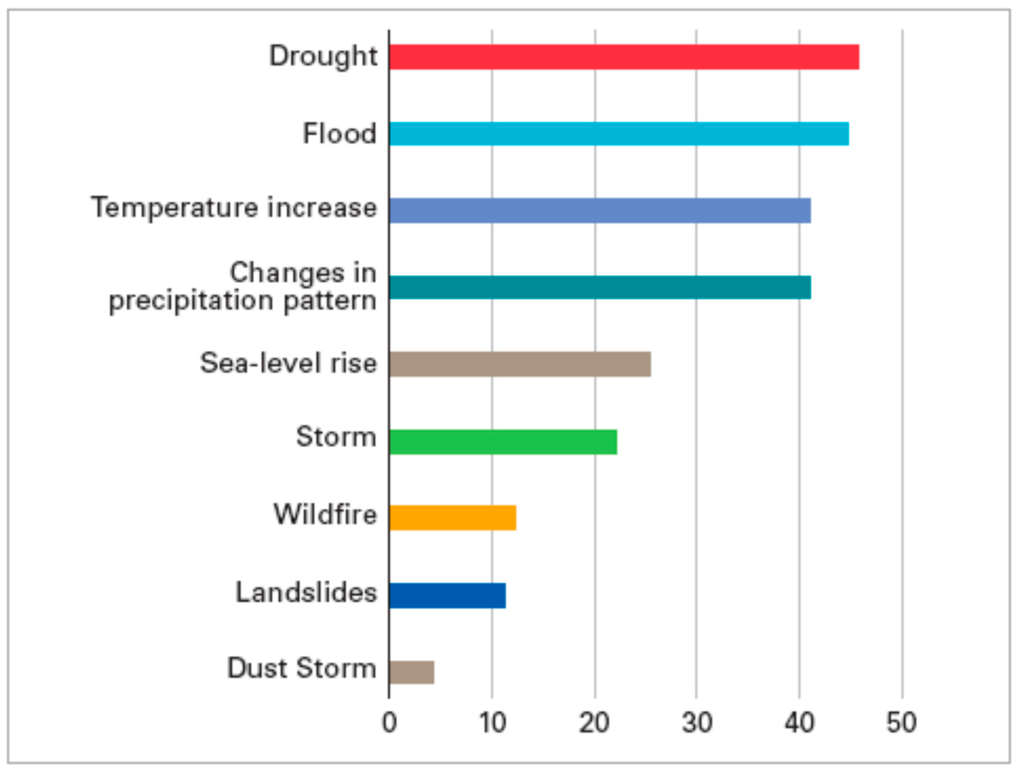
6.1. Climate Variability

The climate is affected by the exchange of energy, mass, and momentum among the atmosphere, ocean, biosphere, land surface, and cryosphere on all time scales, which results in regular variations in climatic variables such as rainfall [99]. The associated distributions of particular types of events, such as floods, occurring at a certain place and time scale also fluctuate [130,131]. This regular variation is a type of natural climate variability known as “modes” or “oscillations.” These modes include the Atlantic Multidecadal Oscillation (AMO), El Niño-Southern Oscillation (ENSO), the Pacific North American Pattern (PNA), the Pacific Decadal Oscillation (PDO), the North Atlantic Oscillation (NAO), the Northern and Southern Annular Modes (SAM), the Indian Ocean Dipole (IOD), and the East Atlantic pattern (EA) [101,132,133]. They fluctuate over a wide range of spatial and temporal scales, and their changes can have an impact on temperature variations at any scale [101].
Previous studies on climate have revealed that, for most regions, the two to three decades from the 1920s to the 1950s appear to have been different from the remainder of the 20th century in some ways. For instance, it appears that during this time, the tropical Pacific’s ocean–atmosphere interactions were different. The first half of the 20th century encompassed exceptional events, several of which are touched upon: Indian monsoon failures during the turn of the century, droughts and extreme heat waves in North America in the 1930s, the World War II period drought in Australia between 1937 and 1945, and the European droughts and heat waves of the late 1940s and early 1950s [134].
In addition, in some areas of eastern and western North America, the linkages between large-scale continental hydrology and simple oceanic and atmospheric indices of tropical Pacific activity are different from those of previous and later decades [130]. Using detrended temperature data representing the early and late 20th century, Hamlet and Lettenmaier showed that spatially homogeneous temperature changes over the western United States in the 20th century, on the order of +1 °C per century, have resulted in significant changes in flood risks over much of the region [135]. The study also demonstrated that warmer transient basins along the coast, particularly those in Washington, Oregon, and California, are likely to exhibit increasing flood risk. Flood risks are significantly impacted by climate fluctuations linked to the PDO and ENSO [135].
Ficchi and Stephens revealed that ENSO and IOD are the most significant modes of climate variability in various parts of Africa while recognizing the impact of other climatic modes on rainfall. Their study also identifies significant time discrepancies for yearly flood episodes between the positive and negative phases of the IOD and ENSO, in some cases exceeding three months [132]. Another study looked at the ENSO, NAO, and EA throughout their neutral, positive, and negative phases to better understand the links between the occurrence and intensity of excessive rainfall, the occurrence of floods, and the damage caused by floods. It was found that the NAO and EA’s positive and negative phases are associated with increased (or decreased) frequency and intensity of heavy seasonal rainfall across most parts of Europe. The association between ENSO and the frequency and intensity of extreme rainfall in Europe is significantly smaller than the relationships with NAO or EA, although it is still significant in some locations. The study also demonstrates that flood damage and flood occurrence are substantially connected with climate variability, notably in southern and eastern Europe [133].
Räsänen and Kummu [136] reveal that ENSO significantly affects the hydrology of the Mekong River Basin in Southeast Asia, especially in the years following ENSO episodes. They further stated that the southernmost regions of the basin experienced the greatest influence of precipitation and discharge and that the discharge association showed decadal changes as well [136].
While the natural climate system’s variability and impacts are evident in the literature, anthropogenic influences in pursuit of industrialization and economic growth are altering these natural processes and are often difficult to comprehend and control due to the unpredictable nature of human behaviors. If these influences are not controlled and made climate-sensitive, they will keep changing the natural climate systems and worsen floods and other impacts.

6.2. Urbanization

6.2.1. Urbanization Status All over the World

In the last two decades, many researchers around the world have conducted studies on urbanization, water resources, and hydrological modeling. According to the Scopus data, there are 679 publications with urbanization, hydrology, modeling, and water as keywords, as seen in Figure 14 [137]. Most of these studies were conducted in the United States, China, India, England, Canada, Germany, Australia, France, Brazil, Italy, South Korea, the Netherlands, Turkey, and Japan, in that order, as illustrated in Figure 15 [137]. The increasing rate of urbanization in the regions with the most deadly floods in the world, such as China, India, Japan, Italy, America, Brazil, the Netherlands, Pakistan, and Bangladesh, has led to an increase in the number of flooding events in these areas [116]. According to the data presented in Figure 16 [138], the number of citations of these studies has gradually increased since the early 2000s, with flood disasters peaking in the 2000s. This indicates the urgency of addressing this issue and highlights the importance of recognizing the relationship between urbanization and flooding events. Research into floods has seen a noticeable increase over the past 30 years. In particular, the 2000s saw a shift in focus to research on flood events, which are often a consequence of urbanization. To analyze this trend, the Global Flood Database (2022) examined the number of documents, publication dates, and citations. This revealed that some of the studies were conducted in the aftermath of the flood events and in the following period.
According to research conducted on the Web of Science (WoS), a total of 975 studies were published with the keywords “urbanization”, “hydrology”, “modeling”, and “water” over the past 20 years [139], as seen in Figure 17. The number of citations for these studies began to increase in the early 2000s. The majority of these studies were conducted in countries such as China, America, India, Germany, Australia, Canada, England, Italy, France, South Korea, Brazil, Japan, the Netherlands, and Turkey, as demonstrated in Figure 18 as Scopus data. This study highlights the importance of considering geographical location and structure when conducting urbanization planning and measures for events from a holistic perspective. The comparison of Scopus and WoS data has revealed that these topics have been mostly investigated in certain countries, although the majority order has changed.
Overall, the research shows that urbanization has a significant impact on flooding, both directly and indirectly. To reduce flood risk, strategies must be developed to mitigate the direct effects of urbanization and address the indirect effects of water withdrawal and land-use change.

6.2.2. Urbanization Impacts on Floods

Urbanization is a process of population concentration in urban areas, resulting in the growth of cities and their associated infrastructure. As cities become increasingly populated, the demands for water resources also increase, leading to a variety of changes in the environment. One of the most significant impacts of urbanization on water resources is the increased pressure on existing water sources. As cities become larger and more populous, the demand for water increases [126,127]. This can lead to the over-extraction of existing water sources, such as rivers, lakes, and aquifers, resulting in water shortages and reduced water quality. Additionally, the increased demand for water from urban areas can lead to the displacement of traditional water sources and their associated cultural practices, resulting in a loss of cultural identity [140,141]. Urbanization can also lead to degradation of water quality due to the introduction of pollutants into water sources. This is due to increased human activities associated with urban development, such as the discharge of industrial wastewater and agricultural runoff into water sources. These pollutants can lead to the eutrophication of bodies of water, causing algal blooms and other environmental impacts [142]. Urbanization can lead to the introduction of non-native species into water sources, which can have a variety of impacts on the ecology. These species can compete with native species for resources and can disrupt food webs, resulting in a decrease in biodiversity. Finally, urbanization can also have an impact on the hydrological cycle. The presence of impervious surfaces, such as roads, roofs, and parking lots, can reduce the infiltration of water into the ground, leading to increased surface runoff and decreased groundwater recharge [141,143]. This can lead to flooding and increased erosion of rivers and streams, resulting in a decrease in water quality and aquatic life.
Urbanization has a significant impact on flooding, both directly and indirectly. Directly, urbanization increases the impervious surface area, which accelerates runoff and increases the probability of flooding. Indirectly, urbanization can cause modifications to the local hydrological cycle, such as increased water abstraction, increased evapotranspiration, and changes in land use. A bibliometric analysis of the literature on the effects of urbanization on flooding reveals that the majority of research has focused on the direct effects [141]. In particular, there is a wealth of research examining the impacts of urbanization on surface runoff and the associated increase in flood risk. This research has largely focused on the development of urban hydrological models, the application of these models in urban areas, and the development of strategies to reduce the risk of flooding [141,144]. The literature on the indirect effects of urbanization on flooding is much more limited. Research in this area has largely focused on the impacts of water abstraction and land-use change on the local hydrological cycle and the associated impacts on flooding [145].
Although floods have occurred throughout the history of mankind, the frequency of floods has increased along with the development of urbanized areas. The seasonal distribution of floods in Rome from 414 BC to 2000 AD is indicated in Table 1. From 414 BC to 399 AD, a very limited number of floods are indicated. However, from 400 to 1699 (i.e., 13 centuries) 30 floods occurred and from 1700 to 2000 (i.e., only 3 centuries) 76 floods were recorded. Therefore, even allowing for missing records, an increasing trend of floods can be seen in Rome (Table 1) [66].
Historically, urbanization has developed at a very slow rate since prehistoric times. Until the middle of the last century, only New York was considered a megacity, i.e., a city with a population of more than 10 million. Today, there are about 45 in the world [146]. In 1800, less than 10% of people lived in urban areas. Today, more than 4.3 billion people, or 55% of the world’s population live in urban settings. By 2050, approximately 70% of the world’s population will live in cities, urban areas, and metropolitan centers, where the future of humanity is “stacked” and built.
Thus, urbanization has had a drastic impact on the management of stormwater runoff. It has influenced the quality of storm runoff, has reduced infiltration, and has increased both the peak and the volume of runoff. Management measures by which the volume and pollution of stormwater could be reduced are as follows: (a) collection, storage, and reuse, (b) infiltration into porous surfaces, and (c) facilitating its evaporation [28]. Management strategies in urban areas aim to ensure flood risks will be eliminated and conservation and reuse will be improved. Such strategies include, among others, green roofs, pervious pavements, grid pavers, rain gardens, vegetated swales, disconnection of impervious surfaces, and of course collection, storage, and reuse of rainwater [147]. This year, Pakistan has received nearly twice as much rain as the 30-year average, totaling 390.7 mm. These torrential rains and flooding have submerged a third of the country and killed more than 1191 people, including 399 children; the United Nations appealed for aid on Tuesday for what it described as an “unprecedented climate catastrophe” [148]. A recent fast attribution study found that human-caused climate change increased the risk of fatal flooding in West Africa in 2022 by about 80 times. Floodwater caused more than a million hectares of farmland to be devastated and displaced 1.3 million people in Nigeria alone, where the catastrophe was described as the most disastrous in a decade. Severe flooding killed more than 800 people in Nigeria, Niger, Chad, and neighboring countries between June and October 2022 [149]. In addition, numerous Sudanese states endured severe and persistent rainfall in 2022. Infrastructure and many houses were damaged by flash floods, which also caused thousands of people to be displaced [150].
The top ten countries with the highest proportion of poor and flood-prone people are all in Africa: South Sudan, Congo Republic, Madagascar, CAR, Malawi, Guinea Bissau, the DRC, Mozambique, Liberia, and Mali [13]. Over 71 million people in Sub-Saharan Africa are estimated to live in both extreme poverty and significant flood risk [4].
In fact, over 1100 flood-related disasters have been reported over the previous 50 years, causing over 43,000 deaths in Africa and affecting 13.4 million people annually [5,151]. This presents a variety of challenging issues for managing floods across the continent, such as reducing the risk of flooding for the 238 million people who live in sub-Saharan informal settlements, managing flood regimes in sizable, transboundary river basins such as the Niger and Zambezi, and forecasting extreme flood flows in ungauged catchments in arid regions of North Africa [152]. Climate-related costs for African nations might reach USD 50 billion annually by 2050, according to forecasts [5].
Droughts and floods combined to kill 43,625 people between 1990 and 2019 in Africa, harming 13.4 million people annually and costing at least USD 456 million in economic losses (Figure 19). On a continent already struggling with extreme poverty and food insecurity, the current climate crisis is predicted to amplify the destructive effects of floods and droughts; adapting to climate variability is an essential concern [151].

6.3. Spreading of Emerging Pollutants and Contaminants

Floods may induce the spreading of a variety of pollutants and contaminants, such as organic compounds, originating from human metabolism or discharges, i.e., pharmaceuticals (e.g., personal care products and antibiotics) and endocrine-disrupting compounds (EDCs), disinfection by-products (DBPs), perfluoroalkyl and polyfluoroalkyl substances (PFAS), pesticides–herbicides, metals, and others. These compounds, under severe flooding events, may be transferred from the land-use areas (e.g., natural, agriculture–livestock, and manufacturing/industrial lands, areas with wastewater discharges) to the underlying soils, surface waters, and sediments, groundwater, and coastal areas. They may thus change the quality of the environment (e.g., causing eutrophication), induce the antibiotic resistance of microorganisms, and threaten microbiota and animal and human life [153,154,155,156]. The main pathway causing contamination/pollution is runoff and soil erosion (contaminants/pollutants absorbed into soil particles); however, transport through the soil profile is possible. In the next paragraphs the main emerging pollutants/contaminants that should be of concern, particularly in sites vulnerable to flooding events, are summarized.
Antibiotics and antibiotic resistance have been recognized by the World Health Organization (WHO) as critical public health issues for the 21st century [157]. Antibiotics (such as beta-lactam, macrolide, quinolone, sulfonamide, trimethoprim, and tetracycline) and antibiotic-resistant genes (ARGs) are transported to aquatic environments [157,158,159,160]. These substances originate from municipal wastewater effluents or other anthropogenic activities and they can degrade the quality of drinking water resources, soils, and plants, and/or induce antibiotic resistance, thus increasing the risk to humans’ health [161].
Likewise, the spreading of metals, e.g., mercury, cadmium, copper, nickel, chromium, or iron, in aquatic reservoirs is also important to ARGs and gene transfer pathways, impacting the quality of reservoirs and their potential to harm animal and human life [162,163].
The EDCs are another category of contaminants [164,165], defined as “exogenous substances or mixtures that alter the function(s) of the endocrine system and consequently cause adverse health effects in an intact organism, its progeny, or (sub) populations”. So far they have been identified in domestic effluents, sludge/biosolids, industrial wastewaters, landfill effluents, livestock wastes, and aquatic reservoirs [166,167,168].
A recent study highlighted the presence of polyfluoroalkyl substances (PFASs) in many locations worldwide. These compounds are of high resistance regarding their degradation and may cause severe harmful effects on humans.
Finally, a small fraction of plastics, e.g., polyamide nylon 6 (PN6), polyethylene (PE), or polyvinyl chloride (PVC), known as microplastics (<5 mm), have been found in terrestrial and aquatic ecosystems associated also with harmful effects on microorganisms, plant species, and humans [169,170]. Recent studies have revealed the ability of specific types of microplastics (i.e., PN6) that can act as carriers of anionic dyes [171], nitrate [172], and antibiotics [173], transforming microplastics into potential long-range carrier material that can cause severe pollution/contamination to the environment [170,174,175].
Worldwide, there are several examples of contaminated water resources due to major flood events causing the transfer of pathogens and chemical substances to surface and subsurface water. An example is the Adyar River of Chennai, a major city in India, where extreme flooding and inundated wells led to an increase in concentrations of various pollutants (e.g., ions, trace metals), and contaminants in groundwater [176]. There, detected pathogens showed resistance to antibiotics, such as ceftriaxone, doxycycline, and nalidixic acid [176]. In Colorado, USA, across the Colorado Front Range, extreme floods in 2013 caused damage to infrastructure and private homes, impacting the whole Cache La Poudre River watershed [177]. There, 277 ARGs subtypes were identified across samples, covering areas that are pristine and historically heavily influenced by wastewater treatment plants and animal feeding operations. From a positive perspective of floods, the concentrations of accumulated antibiotics in fresh-water Poyang Lake, in China, decreased during flood season due to dilution [178]. In Houston, Texas, in the USA, changes in antibiotic resistance and soil microbial communities were detected even after months of urban flooding events caused by Hurricane Harvey [179]. In Australia, a study showed that an intense Brisbane River flood that occurred in 2011 mobilized previously stored metal-rich sediments (e.g., containing zinc, lead, copper, nickel, chromium, manganese, and phosphorus), delivering them to coastal waters. Authors highlighted the magnitude of floods in subtropical regions as an important factor in controlling metal transport to coastal waters [180]. Finally, there is limited field evidence regarding the spreading of microplastics after major flooding, e.g., a threefold increase in microplastic concentration was observed in India; in the Adyar and Cooum River catchment area the values were 240 mm and 227 mm, respectively, following a flood event on 23 November 2015 [181].

6.4. Flooding and the Food System Notion

According to Reed et al. [182], flooding had an impact on the food security status of 12% of those who experienced food poverty in Africa between 2009 and 2020. Flooding and the accompanying meteorological circumstances can also concurrently worsen local food security while improving it at regional geographical scales, resulting in significant changes in the outcomes for overall food security.
Current studies on food security make extensive use of the food system model, which seeks to clarify the complexities of societal food acquisition. One ongoing project is the University of Oxford Martin project, which defines the food system notion as follows:
“The food system is a complex web of activities involving the production, processing, transport, and consumption. Issues concerning the food system include the governance and economics of food production, its sustainability, the degree to which we waste food, how food production affects the natural environment and the impact of food on individual and popular health”.
The Oxford project is highly inspired by Ericksen’s model [183] for a modern and global food system linking five elements as shown in Figure 20. According to Ericksen, a food system consists of all those environmental and socio-economic factors, which in concert constitute the strategies of a society to uphold its food system outcomes or degree of food security. This is not a constant or “steady-state” system in balance (ecosystem terminology), but a system that tends to fluctuate and change from time to time. This important point is actually not very prominent in other definitions of food systems applied to the study of our contemporary (globalized) world.
For our purpose, one important point about Ericksen’s definition of the food system is its dependency on socioeconomic and environmental drivers, respectively. On the one hand, environmental drivers would determine access to the essential precondition for agricultural production (land, soil, water, climate, etc.), and on the other hand the socio-economic drivers determine how the basic productive elements converge to food and are made accessible to the recipient. In the above example from modern Crete, the implications of erratic weather phenomenon such as flooding for food security involve questions of how flooding impacts local productive facilities, and the second concern is how local farmers and authorities possess the right measures to counter the negative effects of flooding. As demonstrated by the examples from Greece above, the successful upholding of local food systems is essential to sustain populations in rural regions, and this precondition measures against destructive weather phenomena. Alternatively, rural populations tend to migrate towards major urban centers and rural regions experience depopulation. We expect future studies of climate variability will clarify more precisely the correlation between erratic weather and food security.

6.5. Causes and Measures for Protection from Floods

Developing protection measures against major flooding events requires understanding the fate, and underlying mechanisms and processes, of pollutants and contaminants, as well as the changes caused in infrastructure, environment, biodiversity, and food chains. This information should be combined with other social-economic priorities and goals in an integrated approach. The aim of such an approach would be to produce effective flood risk management for either urban or agricultural/natural waste streams, targeting flood mitigation and the protection of sustainability of natural (soil and water) resources, quality of life, and economy [184]. For example, a study simulated the future flood risk for the Belgian coast, by using climatic and socioeconomic projections, as well as the value of specific spatial adaptation measures, including land-use zoning and compartmentalization, projecting a reduction in flood risk from 10 to 60% [185]. Recently, a review study divided different flood-management measures, targeting reduction of specific risk components (e.g., hazard, exposure, and vulnerability) [186], into four classes: (a) flood abatement (rain harvesting, reforestation, soil conservation, and groundwater recharging); (b) flood control (retention and storage water, dykes, floodwalls, flow diversion, river re-profiling, river conveyance); (c) flood alleviation (encroachment control, building codes, rescue, evacuation, land-use adaptation, flood proofing, and public awareness); and (d) recovery from floods (insurance, relief efforts, and compensation) [186]. According to the authors, each of the measures should be evaluated based on the reduction of risk under site-specific economic, social, topographical, or environmental constraints [186]. Despite the progress that has been made in studying floods and their impacts on the environment, infrastructure, and economy, there are still great challenges, particularly due to uncertainties arising from the applied hydrological, flood damage, climate, and population and economic growth models [187,188]. Understanding of these uncertainties would help risk communication, policy decisions, and the development and application of adaptation strategies and measures [164]. Another domain of research could focus on the short- or long-term impacts of the proposed measures/strategies/policies on different sectors (e.g., infrastructure, society, and economy). A standardized assessment tool or framework, which involves the interactions between sectors, has been proposed to improve the resilience of flood-mitigation actions [184]. In the EU, floods are treated in the European Directive 2007/60/EC, suggesting the following for river basin districts of the member states: (i) preliminary flood risk assessment, (ii) flood hazard and risk maps, and (iii) flood risk-management plants (includes measures for achieving prevention and/or reduction of the adverse consequences of flooding for human health, the environment, and economic activity). Moreover, there are relative guidelines, such as those concerning the dissemination of specific pollutants/contaminants, pharmaceuticals (e.g., antibiotics), and anti-microbial resistance and other organic and inorganic compounds, [189]. Other relevant proposed EU strategies and policies for flood management are those for pharmaceuticals [190], sustainable and toxic-free environment [191], “Zero Pollution for Air, Water and Soil” [192], microplastics [193], and the endocrine disruptors’ [194,195]. Currently, at the EU member state scale, a risk-based flood-management approach is adopted by countries, such as Germany and Netherlands, according to the EU flood directive (2007/60/EC); the Netherlands adopted the framework Multi-Layer Safety to achieve flood protection, sustainable spatial planning, and emergency management [196]. Germany, after the disastrous floods in 2002 along the Elbe and the Danube rivers, revised the national framework legislation regarding spatial planning and household and business damage prevention [196]. Climate challenges contributed further to the application of more efficient and multipurpose usage flood adaptation measures. The USA has adopted flood risk management, named the Federal National Flood Insurance Program, introducing requirements for buildings and flood zoning [196]. Flood mapping is also carried out by the US Federal Emergency Management Agency, providing data for the understanding of flood hazards and the assessment of the protection measures at a local scale [188].

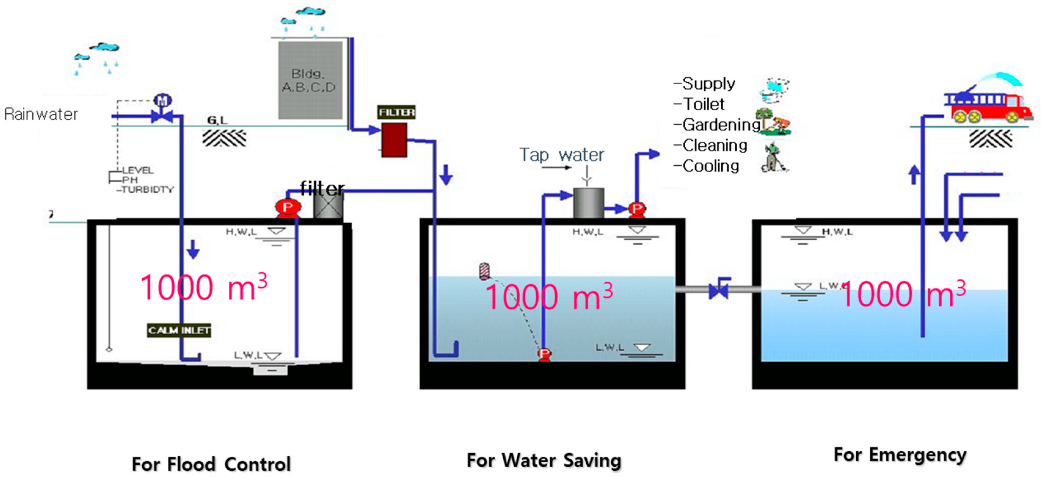
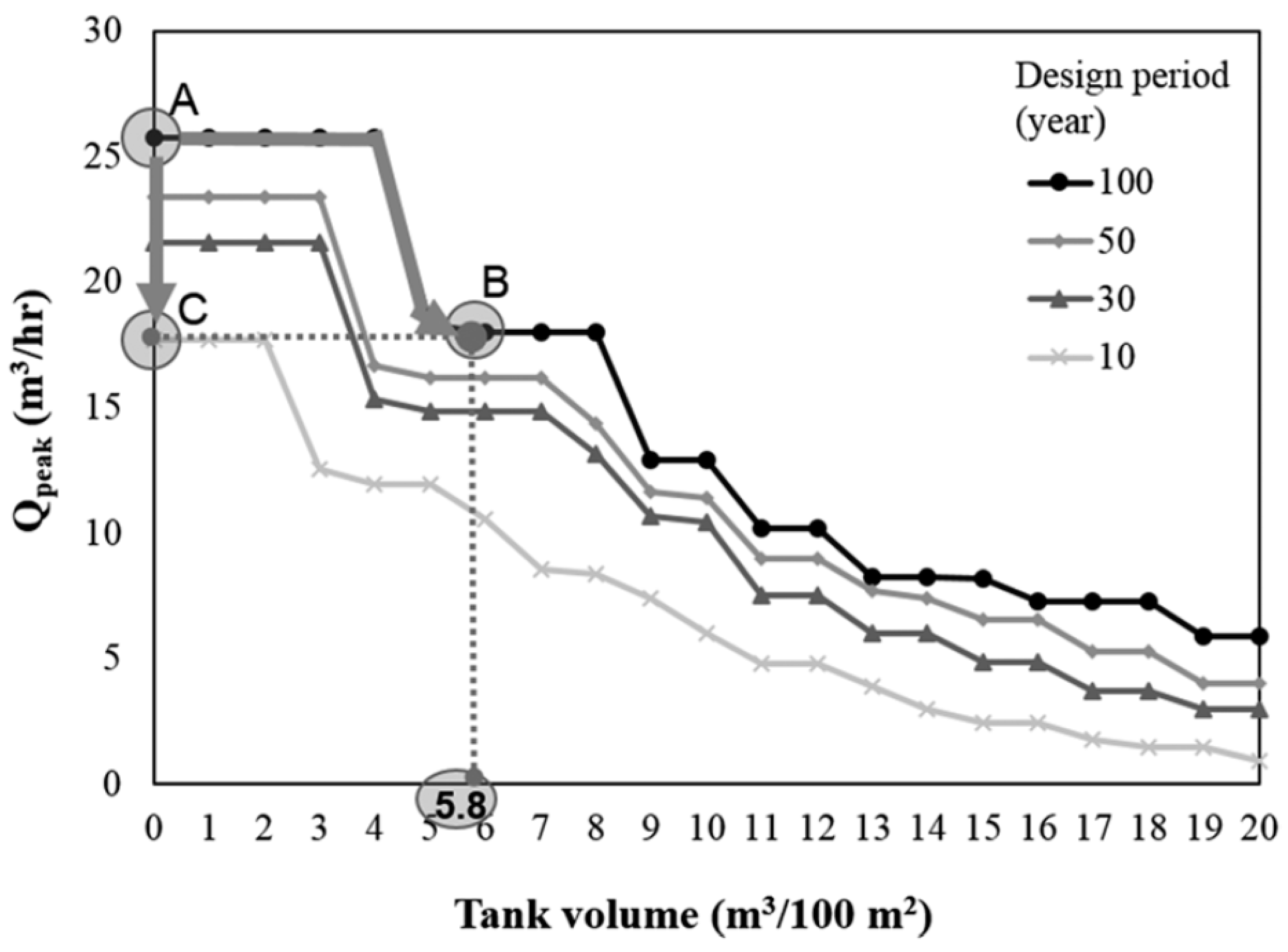
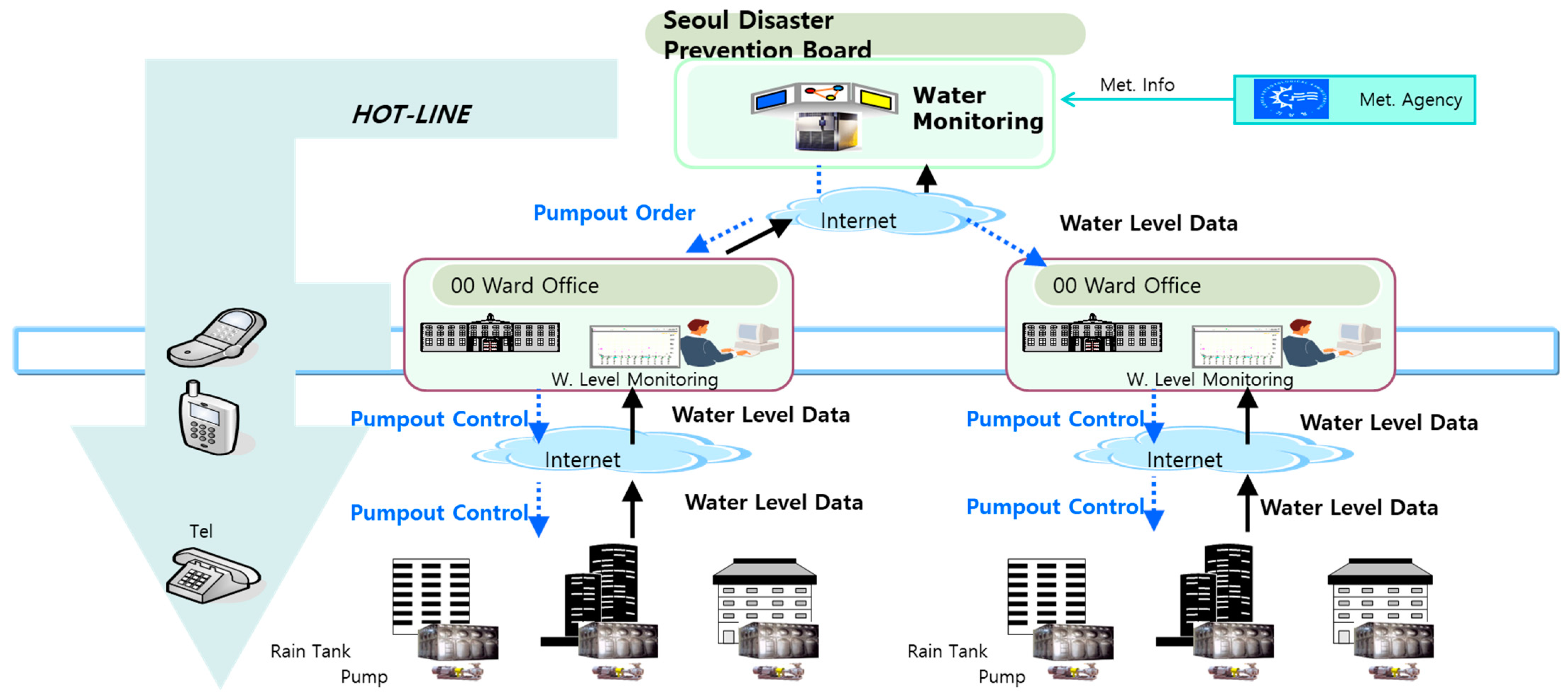
6.5.1. Case Study at Korea: Star City Rainwater Management

Motivated by the Korean philosophy and tradition of respecting rainwater, a modern example is a model of decentralized multi-purpose rainwater management in Seoul, Korea, known as the Star City project. The Star City—located in the northeastern part of Seoul, near the Han River, South Korea—is a major real-estate development project of more than 1300 apartments. The Star City rainwater harvesting system (RWHS) has been operating since 2007 and is receiving worldwide attention as a model water-management system that supplements the existing centralized water infrastructure strategy [197].
Several innovative concepts have been applied in implementing the Star City RWHS [198]:
(a)
The concept of a multi-purpose system: the system is used in flood mitigation, water conservation, and emergency response.
(b)
The proactive management of flooding: the Star City RWHS has a remote-control system for monitoring and controlling the tank water level. Three different tanks also store water separately according to water quality. The risk of flooding is mitigated with the remote-control system by emptying or filling the tanks appropriately.
(c)
The city government’s incentive program for the developer to alleviate the fear of any economic disadvantage. The developer was permitted to construct three percent more floor space than would normally be allowed. Considering the price of real estate in Seoul, that is a remarkable incentive.
A schematic diagram of the Star City RWHS is shown in Figure 21. A total of 3000 m3 of water is stored in three separate tanks with a total floor area of 1500 m2. The capacity of each tank is 1000 m3. Two of the tanks are used to store rainwater from the rooftops and the ground. Garden irrigation is achieved efficiently by ground infiltration, which is recycled to the tank for multiple uses. The third tank stores emergency tap water. Fresh tap water is maintained by regular replenishment after decanting half of the old water into the rainwater tank.
The total area of the Star City complex is around 51,200 m2, comprising 6200 m2 of rooftops and 45,000 m2 of terrace and garden. When considering the infiltration capacity of the garden, the runoff coefficient of the terrace is assumed to be 60% of that of the roof. The total equivalent area thus becomes ~34,550 m2. The tank volume–catchment area ratio is 5.8 m3/100 m2. As the utilization rate–catchment area ratio is small (ranging from 0–0.3 L/min.100 m2), the Star City RWMS can be designed and analyzed using the R-S-D model. These factors can be plotted on the TP (Tank volume—Peak runoff) curves for the R-S-D system as described in Nguyen and Han [198] and the flood mitigation potential can be evaluated. A 100-year-frequency peak runoff of 26 m3/h (Point A) can be reduced to 18 m3/h (Point B) through a rainwater tank installation with a tank volume–catchment area ratio of 5.8 m3/100 m2, as shown in Figure 22. The peak runoff of 18 m3/h indicates a 10-year-frequency peak runoff (Point C). Therefore, the Star City complex, which has a storage array with a 10-year design period, would protect from a 100-year flood.
The success of the Star City project serves as a model for enacting regulations aimed at rainwater harvesting and management in Seoul. In December 2004, the city authority announced new rules to enforce the installation of RWHSs, with the main purpose of mitigating urban flooding and a secondary purpose of conserving water and extending energy savings. These measures are expected to ensure the safety of the city from future flooding. A special feature of the new system is the provision of a network for monitoring water levels in all water tanks at the central disaster-prevention agency in the City Office (Figure 23). Data will be gathered from each Gu or district office. Depending on the expected amount of rainfall, the central disaster prevention agency may issue an order to building owners to either fully or partially empty their rainwater tanks. An incentive program is planned to reward those who follow the order and penalize those who do not. After a storm event, the stored water can be used for firefighting and non-drinking purposes, such as toilet flushing and gardening.
By 2022, more than 100 local authorities in South Korea had made regulations on rainwater management to promote DRWMSs by providing financial incentives and subsidies, and by establishing operating rainwater committees. Many other cities are planning to make rainwater regulations under the Green Growth Policy of the South Korean government.
The main question is what can/should be done to prevent and/or avoid such events. The most effective solution would be the demolition and reconstruction of our cities after proper urban planning. This is impossible. Therefore, in the future, let us imitate our ancestors and other peoples, at least in the urban planning and infrastructure of our cities. As already mentioned, an interesting example is Hippodamus of Miletus (498–408 BC), architect and town planner and a prominent personality of the ancient Classical world, was initially active in Ionia, and mainly in his place of origin, Miletus. He created the urban plan known as the Hippodamian system, which was not just the application of an orthonormal system of streets, but the more general organization of a city so that its functions were served rationally. It was first applied to Miletus, and then to Priene, Piraeus, Rhodes, Olynthos, Kassope, and elsewhere. Despotopoulos considered it as an expression of the collective logic in the city, as an expression of the conscious and the non-accidental, and indeed as an expression of social collectivity [30].
In addition, alongside proper urban planning, the need for organized rainwater-management practices, i.e., their collection, storage, and use, is imperative. For this, we can introduce our ancestors. The ancient Greeks, from the beginning of the Minoan era, developed rational practices in this field as well. Recently, a study entitled “The cisterns of Santorini, miracles of wisdom and art” was published in the international scientific press, where the wisdom of antiquity is “married” with modern water resource-management technologies in the GWP-Med project, between Cornell University, USA, and the Municipal Water and Sewerage Company of Santorin (DEYAS) [199].

6.5.2. African Cases and Policy

Ancient civilizations in Morocco, such as the Berbers, Phoenicians, and Romans, faced the challenges of seasonal floods and water scarcity and developed innovative methods to manage their water resources. For example:
(a)
The Berbers, who lived in North Africa as early as 3000 BC, developed a sophisticated system of irrigation and water management to make use of the limited water resources available in the region. They built dams, cisterns, and underground channels to store and transport water, and used terracing and other techniques to protect their crops from floods [200].
(b)
The Phoenicians, who established trading colonies along the coast of Morocco, also made use of irrigation systems to cultivate crops and support their settlements. They built cisterns to store rainwater and channeled water from springs to their fields [201].
(c)
The Romans, who conquered the Kingdom of Mauretania and established the city of Volubilis as their capital, also made use of irrigation systems and constructed aqueducts to transport water from distant sources to their cities. They built public baths, fountains, and other public facilities that relied on a constant supply of water [202].
Overall, the ancient civilizations in Morocco developed a range of strategies to cope with the challenges posed by floods and water scarcity and made significant contributions to the field of water management and engineering. These innovations helped to support the growth and development of these civilizations and paved the way for the cultural and technological advances of subsequent generations.
African inhabitants have used various methods to combat floods and protect their settlements throughout history. Some of these methods include:
(a)
Building levees and dykes. In areas prone to frequent or severe flooding, communities have built levees and dykes to protect their settlements. The ancient Egyptians, for example, built a system of levees and dykes along the Nile River to prevent flooding and preserve their fertile agricultural land.
(b)
Relocating settlements. In some cases, communities relocated their settlements to higher ground to avoid flood-prone areas. This was common in areas where seasonal or irregular floods were a regular occurrence.
(c)
Improving drainage systems. In areas with poor drainage, communities have improved drainage systems to reduce the risk of flooding. For example, in some African cities, the authorities have built drainage canals and improved the infrastructure to prevent flash flooding during heavy rains.
(d)
Developing early warning systems. In some communities, early warning systems have been developed to give residents advance notice of impending floods. This allows them to take appropriate action to protect their settlements, crops, and livestock.
These methods have been used to varying degrees across Africa, and the strategies used have varied depending on the local climate, geography, and resources. Nevertheless, combating floods has been a continuous challenge for African inhabitants, and adapting to changing environmental conditions remains a key concern for communities across the continent.
To address the ongoing challenges and those that will arise in the future, considerably more work must be done. Due to this, the IFRC and Movement partners continue to support African National Societies in addressing the needs and enhancing the quality of life for marginalized populations throughout Africa, both before and after disasters and crises [4]. African National Societies launched 52 small-scale response operations through the IFRC’s Disaster Emergency Relief Fund (DREF) with budget funding of 80 million Swiss francs, targeting 1.9 million people, and 11 larger responses through IFRC Emergency Appeals with budget funding of 11 million Swiss francs, targeting 564,000 people, since January 2019, in response to floods, flash floods, landslides, and cyclones [4].
By enabling the development of a national disaster risk-management strategy, supporting structural risk-reduction investments for more than 174,000 beneficiaries, insuring nearly 9 million people against bodily injury in catastrophic events, and establishing a solidarity fund benefiting nearly 6 million of Morocco’s poorest and most vulnerable citizens, the Morocco Integrated Disaster Risk Management and Resilience Program has helped strengthen Morocco’s disaster and climate resilience [116]. Dam policy, which was set up in Morocco in the late 1960s, is today regarded as one of the best practices for flood protection and improving water supplies.
The private sector seems interested in funding adaptation to new circumstances in Africa and elsewhere. Nevertheless, it will not act unless it is persuaded that doing so will have a beneficial economic impact, which is still a concern given how little awareness there is among businesses of the opportunity costs of inaction and the potential technologies that might be used [151].

7. Epilogue

Floods are phenomena that occur throughout the world without distinguishing between developed and developing countries. The global forecasts for the risk of flood events show that a large part of the planet will face increased problems due to population increase, urbanization, and the reduction and/or deficit management of forestlands. The risk is particularly high in closed basins (an internally draining watershed, whose waters do not flow to the sea or ocean) which are not surrounded by karst rocks and are drained by sinkholes with low maintainability and mainly low drainage capacity.
Since prehistoric times, important developments have included the implementation of hygienic living standards, advanced hydraulic technologies for water transportation, constructions for flood and sediment control, and sustainable urban water-management practices, which can be compared to modern-day practices. In a brief overview of the history of flooding in ancient times from the Early Bronze Age to the present day, three major periods were considered: the prehistoric to the medieval period (ca 7600 BC–1400 AD), the early and middle modern period (1400–1900 AD), and the modern period (1900 AD to date) [26]. For example, Nile flooding has marked the most important ecological cycle in Egypt since ancient times. Ancient Egyptians’ lives were highly affected by the Nile summer floods. Egyptians adopted early many technologies to control these floods.
Floods have been a recurrent natural disaster in India throughout history, with references to floods in ancient Indian texts such as the Vedas. In ancient times, floods were mainly caused by heavy monsoon rains and overflowing of rivers such as the Indus, Ganges, and Brahmaputra. These floods resulted in significant loss of life and property damage. As the population grew, and urbanization and deforestation increased, the impact of floods became more severe. Climate variability also has an impact on floods in India, with heavier rainfall and rising sea levels exacerbating the problem. In recent years, the Indian government has implemented various measures to mitigate the impacts of floods, such as building dams and embankments, early warning systems, and disaster-management plans. However, despite these efforts, floods continue to cause significant damage and loss of life.
Throughout all these above-mentioned periods, climatic conditions do not seem to have changed drastically, but they nevertheless exhibit intense variability also for prolonged periods [203]. Recent climate variability and/or climate change has a great impact on flood quantity and frequency everywhere, driven not only by alterations in precipitation patterns, but also by changes in land use by humans, which increase the flooding risk. Deforestation, for example, reduces the capacity of the land to absorb water, leading to increased runoff and the potential for flooding. Furthermore, increase in global temperature due to increased greenhouse gas emissions may result in melting of glaciers and polar ice caps, and, subsequently, a rise in sea level. This may increase the risk of coastal flooding from storm surges.
Decision-making must be directed toward policies in which lessons from past floods have been included. Developing precise hydrological models to forecast river discharge, heavy rainfalls, and flash floods would be beneficial for future studies. Decision-making must play a critical role in addressing the impacts of climate variability, particularly in terms of reducing the risk of floods. Effective decision-making can help communities and governments to prepare for and respond to the increasing frequency and intensity of flood events. This can include decisions such as:
(a)
Land-use planning. Decisions about how land is used and developed can have a significant impact on the risk of flooding. For example, decisions about urban development and land use can influence the level of impermeable surfaces and runoff.
(b)
Climate adaptation. Decisions about how to adapt to the impacts of climate variability, such as floods, are crucial. This can include measures such as building flood protection structures, creating early warning systems, and developing emergency response plans.
(c)
Mitigation. Decisions about reducing greenhouse gas emissions and slowing climate variability will also have an impact on the frequency and intensity of floods.
In short, decision-making at all levels (local, national, and international) will play a key role in reducing the impacts of urbanization and protecting communities from the risk of flooding. Moreover, historical flood accounts often contain details of corroborative information (e.g., watermarks), which permit comparison of past events with recent floods or can even be used in the estimation of historical peak discharges. The long periods covered by historical records, relative to systematic instrumental observations, permit a more reliable estimation of high-magnitude low-probability events, providing an important tool in flood risk estimation [204]. Learning from past events is an important tool for better understanding floods and for the provision of more effective protective measures against future events.
Finally, Confucius’ (551–479 BC) saying is confirmed, i.e., “Study the past before planning anything for the future”.

Author Contributions

Conceptualization, A.N.A. has the original idea and was written the original draft. A.G.C. Reviewing and edited. B.T. writing the Climate Variability section. M.V. has contributed in Prehistoric to Medieval Era, Medieval Times, Contemporary Times, and Emerging Trends. J.K. Review and editing, Contributing to Prolegomena, the sections on Ancient and modern Greece, and Food systems, Epilogue. A.T.A. Writing the section on early ancient Egyptians. L.M. Contributed in Prolegomena, Historical Times, Floods in Contemporary Times, Urbanization, Causes and measures for protection from Floods, and Epilogue. V.A.T. Writing the section on spreading pollutants and contaminants and a part for causes and measures for protection from floods section and submitting the manuscript. A.B. and E.B. Writing the section of the Byzantine period, Medieval times, and floods in early and Mid-Modern Times urbanization. R.K. Writing mainly on the part of the manuscript for India. X.Z. and Z.M. Contributing in Prolegomena and Chinese sections. M.H. wrote the part on old Korea during Baekje Dynasty and that on modern Korea. N.D. Contributed to the Greece in ancient times and contemporary times. All authors have read and agreed to the published version of the manuscript.

Funding

This research received no external funding.

Institutional Review Board Statement

Not applicable.

Informed Consent Statement

Not applicable.

Data Availability Statement

Not applicable.

Acknowledgments

Many thanks are due to Madalina Buzatu, Land Journal Relations Specialist for her interest, effort, and contribution mainly in organization two meetings, very productive and development the work plan.

Conflicts of Interest

The authors declare no conflict of interest.

References

  1. Angelakis, A.N.; Voudouris, K.S.; Mariolakos, I. Groundwater utilization through the centuries focusing [omicron] n the Hellenic civilizations. Hydrogeol. J. 2016, 24, 1311. [Google Scholar] [CrossRef]
  2. UN (United Nations). World Urbanisation Prospects 2018. 2018. UN Department of Economic and Social Affairs: Population Dynamics. Available online: https://population.un.org/wup/ (accessed on 15 May 2021).
  3. Douben, K.J. Characteristics of river floods and flooding: A global overview: 1985–2003. Irrig. Drain. 2006, 55, S9–S21. [Google Scholar] [CrossRef]
  4. IFRC (International Federation of Red Cross) and Red Crescent Societies. African Floods Snapshot, May 2021; IFRC (International Federation of Red Cross) and Red Crescent Societies: Geneva, Switzerland, 2021. [Google Scholar]
  5. WMO (World Meteorological Organization). State of Climate in Africa Highlights Water Stress and Hazards; WMO: Geneva, Switzerland, 2022; p. 09082022. [Google Scholar]
  6. Jha, A.; Lamond, J.; Robin, L.; Bloch, R.; Bhattacharya, N.; Lopez, A.; Papachristodoulou, N.; Bird, A.; Proverbs, D.; Davies, J.; et al. Five Feet High and Rising: Cities and Flooding in the 21st Century; Policy Research Working Paper 5648; The World Bank: Washington, DC, USA, 2011; p. 62. [Google Scholar]
  7. WB (World Bank). Indonesia: National Urban Flood Resilience Project (NUFReP). World Bank Project, Project Number: P173671. 2022. Available online: https://projects.worldbank.org/en/projects-operations/project-detail/P173671 (accessed on 28 April 2023).
  8. Goswami, B.N.; Venugopal, V.; Sengupta, D.; Madhusoodanan, M.; Xavier, P.K. Increasing trend of extreme rain events over India in a warming environment. Science 2006, 314, 1442–1445. [Google Scholar] [CrossRef] [PubMed] [Green Version]
  9. Ray, K.; Pandey, P.; Pandey, C.; Dimri, A.P.; Kishore, K. On the recent floods in India. Curr. Sci. 2019, 117, 204–218. [Google Scholar] [CrossRef]
  10. Roxy, M.K.; Ritika, K.; Terray, P.; Murtugudde, R.; Ashok, K.; Goswami, B.N. Drying of Indian subcontinent by rapid Indian Ocean warming and a weakening land-sea thermal gradient. Nat. Commun. 2015, 6, 7423. [Google Scholar] [CrossRef] [Green Version]
  11. Gupta, A.K.; Nair, S.S. Urban floods in Bangalore and Chennai: Risk management challenges and lessons for sustainable urban ecology. Curr. Sci. 2011, 100, 1638–1645. [Google Scholar]
  12. Conway, D.; Persechino, A.; Ardoin-Bardin, S.; Hamandawana, H.; Dieulin, C.; Mahé, G. Rainfall and river flow variability in Sub-Saharan Africa during the twentieth century. J. Hydrometeorol. 2009, 10, 41–59. [Google Scholar] [CrossRef]
  13. Zeufack, A.G.; Calderon, C.; Kubota, M.; Korman, V.; Cantu-Canales, C.; Kabundi, A.N. Africa’s Pulse, No. 24, October 2021; World Bank: Washington, DC, USA, 2021. [Google Scholar] [CrossRef]
  14. Ryan, W.B.F.; Pitman, W.C.; Major, C.O.; Shimkus, K.; Moskalenko, V.; Jones, G.A.; Dimitrov, P.; Gorür, N.; Sakinç, M.; Yüce, H. An abrupt drowning of the Black Sea shelf. Mar. Geol. 1997, 138, 119–126. [Google Scholar] [CrossRef]
  15. Ryan, W.; Pitman, W. Noah’s Flood: The New Scientific Discoveries about the Event That Changed History; Simon and Schuster Publisher: New York, NY, USA, 1998. [Google Scholar]
  16. Ely, L.; Enzel, Y.; Baker, V.R.; Cayan, D.R. A 5000-year record of extreme floods and climate change in the southwestern United States. Science 1993, 262, 410–412. [Google Scholar] [CrossRef]
  17. Shaikh Baikloo Islam, B. Evidence and consequences of the flood in Iran from prehistory to the present. Water Soil Manag. Model. 2021, 1, 24–40. [Google Scholar] [CrossRef]
  18. SASC (St Albans Secondary College). Ancient Egypt: The Nile River. 2022. Available online: https://libguides.stalbanssc.vic.edu.au/ancient-egypt/nile (accessed on 30 December 2022).
  19. Budge, E.; Wallis, A. The Nile Notes for Travelers in Egypt; Thos. Cook & Son (Egypt), Ltd.: London, UK, 1895. [Google Scholar]
  20. Gill, N.S. The Nile River and Nile Delta in Egypt. 2021. Available online: https://thoughtco.com/nile-river-nile-delta-in-egypt-111649 (accessed on 20 April 2023).
  21. Santoro, M.M.; Hassan, F.A.; Wahab, M.A.; Cerveny, R.S.; Robert, C.; Balling, J. An aggregated climate teleconnection index linked to historical Egyptian famines of the last thousand years. Holocene 2015, 25, 872–879. [Google Scholar] [CrossRef]
  22. Stanley, D.J.; Warne, A.G. Nile Delta in Its Destruction Phase. J. Coast. Res. 1998, 14, 795–825. [Google Scholar]
  23. Saxena, K.R. Dams: Incidents and Accidents; A.A. Balkema Publisher: London, UK, 2005. [Google Scholar]
  24. Baba, A.; Tsatsanifos, C.; El Gohary, F.; Palerm, J.; Khan, S.; Mahmoudian, S.A.; Ahmed, A.T.; Tayfur, G.; Dialynas, Y.G.; Angelakis, A.N. Developments in water dams and water harvesting systems throughout history in different civilizations. Int. J. Hydrol. 2018, 2, 150–166. [Google Scholar] [CrossRef] [Green Version]
  25. Whitley, D. Solving Stonehenge: The New Key to an Ancient Enigma. Time Mind 2011, 4, 107–109. [Google Scholar] [CrossRef]
  26. Krasilnikoff, J.; Angelakis, A.N. Water management and its judicial contexts in ancient Greece: A review from the earliest times to the Roman period. Water Policy 2019, 21, 245–258. [Google Scholar] [CrossRef]
  27. Koutsoyiannis, D.; Mamassis, N.; Efstratiadis, A.; Zarkadoulas, N.; Markonis, Y. Floods in Greece; IAHS Press: Wallingford, CT, USA, 2012; Volume 12, pp. 238–256. [Google Scholar]
  28. Angelakis, A.N.; Antoniou, G.; Voudouris, K.; Kazakis, N.; Dalezios, N.; Dercas, N. History of floods in Greece: Causes and measures for protection. Nat. Hazards 2020, 101, 833–852. [Google Scholar] [CrossRef]
  29. Mosso, A. Escursioni nel Mediterraneo e gli Scavi di Creta; Treves: Milano, Italy, 1907. [Google Scholar]
  30. Angelakis, A.N. About Floods; Newspaper Chaniotika Nea: Chania, Greece, 2017; Available online: https://www.haniotika-nea.gr/peri-plimmiron/ (accessed on 15 March 2023). (In Greek)
  31. Gray, H.F. Sewerage in Ancient and Medieval Times. Sew. Work. J. 1940, 12, 939–946. [Google Scholar]
  32. Pendlebury, J.R. The Archaeology of Crete: An Introduction; Biblo & Tannen Publishers: London, UK, 1939; Available online: https://www.aegeussociety.org/en/images/knossos-the-caravanserai-and-viaduct/ (accessed on 15 March 2023).
  33. Evans, A. The Palace of Minos at Knossos: A Comparative Account of the Successive Stages of the Early Cretan Civilization as Illustrated by the Discoveries; Macmillan and Co.: London, UK, 1922; Volume I–IV. [Google Scholar]
  34. Koutsoyiannis, D.; Angelakis, A. Agricultural Hydraulic Works in Ancient Greece. In Encyclopedia of Water Science; Stewart, B.A., Howell, T., Eds.; Markel Dekker Inc.: New York, NY, USA, 2004; pp. 1–4. [Google Scholar]
  35. Fotopoulou, L. The Ancient Dam at Tiryns. Postgraduate Thesis, National Technical University of Athens, Athens, Greece, 2009; p. 172. (In Greek). [Google Scholar]
  36. Fountoulis, I.; Mariolakos, I.; Mavroulis, S.; Ladas, I. Climatic changes and flood periods during the prehistoric and roman times in the Kladeos torrent basin—Ancient Olympia (Greece). In Proceedings of the 8th International Hydrogeological Congress of Greece, 3rd MEM Workshop on Fissured Rocks Hydrology 813, Athens, Greece, 16–19 October 2008; Migiros, G., Stamatis, G., Stournaras, G., Eds.; pp. 809–818. [Google Scholar]
  37. Wright, R.P. The Ancient Indus: Urbanism, Economy, and Society; Cambridge University Press: Cambridge, UK, 2010; p. 1. [Google Scholar]
  38. Doniger, W. The Hindus: An Alternative History; Oxford University Press: New York, NY, USA, 2010. [Google Scholar]
  39. Jansen, M. Water supply and sewage disposal at Mohenjo-Daro. World Archaeol. 1989, 21, 177–192. [Google Scholar] [CrossRef]
  40. Nair, K.S. Role of Water in the Development of Civilization in India—A Review of Ancient Literature, Traditional Practices and Beliefs; International Association of Hydrological Sciences: Wallingford, CT, USA, 2000; Volume 286, pp. 160–166. [Google Scholar]
  41. Fagan, B. Floods, Famines, and Emperors: El Niño and the Fate of Civilizations; Basic Books: New York, NY, USA, 2009. [Google Scholar]
  42. Possehl, G.L. The Indus Civilization: A Contemporary Perspective; AltaMira Press: Lanham, MD, USA, 2002. [Google Scholar]
  43. Khan, S.; Dialynas, E.; Kasaraneni, V.; Angelakis, A. Similarities of Minoan and Indus Valley hydro-technologies. Sustainability 2020, 12, 4897. [Google Scholar] [CrossRef]
  44. Douglas, I. Cities: An Environmental History; I. B. Tauris: London, UK; New York, NY, USA, 2013. [Google Scholar]
  45. De Feo, G.; Antoniou, G.P.; Mays, L.W.; Dragoni, W.; Fardin, H.F.; El-Gohary, F.; Laureano, P.; Kanetaki, E.I.; Zheng, X.Y.; Angelakis, A.N. Historical Development of Wastewater Management. In Handbook of Engineering Hydrology; Eslamian, S., Ed.; Taylor & Francis Group: Boca Raton, FL, USA, 2014; Volume 2, pp. 163–217. [Google Scholar]
  46. Maner, A.W. Public works in ancient Mesopotamia. Civ. Eng. 1966, 36, 50–51. [Google Scholar]
  47. Reynolds, R. Cleanliness and Godliness; Doubleday and Company, Inc.: New York, NY, USA, 1946. [Google Scholar]
  48. Gu, B. Ditch-River Graph in the Han Book; Zhonghua Book Company: Beijing, China, 1962; p. 271. [Google Scholar]
  49. Shan, D. The Ancient Legend and Nation; The Commercial Press: Beijing, China, 2005; pp. 179–186. [Google Scholar]
  50. Shillington, K. History of Africa; St. Martin’s: New York, NY, USA, 1989. [Google Scholar]
  51. Török, L. The Kingdom of Kush Handbook of the Napatan-Meriotic Civilization; Brill: Leiden, The Netherlands, 1997. [Google Scholar]
  52. Glaeser, E. Triumph of the City: How Our Best Invention Makes Us Richer, Smarter, Greener, Healthier, and Happier; Penguin Press: New York, NY, USA, 2011; p. 19. ISBN 978-1-59420-277-3. [Google Scholar]
  53. Murray, W.M. The Ancient Dam of the Mytikas Valley. Am. J. Archaeol. 1984, 88, 195–203. [Google Scholar] [CrossRef]
  54. Zarkadoulas, N. The Dam of Ancient Alyzia. Postgraduate Thesis, National Technical University of Athens, Athens, Greece, 2005. (In Greek). [Google Scholar]
  55. Lohmann, H. Atene: Forschungen zu Siedlungs- und Wirtschaftsstruktur des klassischen Attika; Böhlau: Vienna, Austria, 1993. [Google Scholar]
  56. Krasilnikoff, J. Innovation in ancient Greek agriculture: Some remarks on climate and irrigation in Classical Attica. Class. Mediaev. 2014, 64, 95–116. [Google Scholar]
  57. Krasilnikoff, J.A. Irrigation as innovation in ancient Greek agriculture. World Archaeol. 2010, 42, 108–121. [Google Scholar] [CrossRef]
  58. Walker, K.G. Archaic Eretria: A Political and Social History from the Earliest Times to 490 BC; Routledge: London, UK, 2004. [Google Scholar]
  59. Komorowska, J. THEOPHRASTUS’DISCUSSION OF WINDS-(R.) Mayhew (ed., trans.) Theophrastus of Eresus: On Winds.(Philosophia Antiqua 147.) Pp. x+ 374. Leiden and Boston: Brill, 2018. Cased,€ 165, US $190. Class. Rev. 2019, 69, 408–409. [Google Scholar] [CrossRef]
  60. McClellan, J.E.; Dorn, H. Science and Technology in World History: An Introduction; JHU Press: Baltimore, MD, USA, 2015. [Google Scholar]
  61. Shamasastry, R. Kautilya’s Arthasastra; Mysore Publishing and Printing House, Mysore Press: Mysore, India, 1967; p. 517. [Google Scholar]
  62. Shastri, J.L.; Tagare, G.V. The Narada-Purana Part 1: Ancient Indian Tradition and Mythology; Motilal Banarsidass: New Delhi, India, 2004; Volume 15, p. 497. [Google Scholar]
  63. Jamison, S.W.; Brereton, J.P.E. The Rigveda: The Earliest Religious Poetry of India (Vol. 1); South Asia Research; Oxford University Press: New York, NY, USA, 2014. [Google Scholar]
  64. Narayan, R.K. The Mahabharata: A Shortened Modern Prose Version of the Indian Epic; University of Chicago Press: Chicago, IL, USA, 2016. [Google Scholar]
  65. Di Baldassarre, G.; Saccà, S.; Aronica, G.T.; Grimaldi, S.; Ciullo, A.; Crisci, M. Human-flood interactions in Rome over the past 150 years. Adv. Geosci. 2017, 44, 9–13. [Google Scholar] [CrossRef] [Green Version]
  66. Aldrete, G.S. Floods of the Tiber in Ancient Rome; JHU Press: Baltimore, MD, USA, 2007. [Google Scholar]
  67. Linoli, A. Land Reclamation, Irrigation and Flood Protection, in Italy over the Centuries; ITAL-ICID: New Delhi, India, 2019; p. 50. [Google Scholar]
  68. Yang, K. Re-discussion on the design of Chang an in West Han Dynasty. Archaeology 1989, 4, 348–356. [Google Scholar]
  69. Zheng, X.Y. Drainage in ancient China: Historical wisdom and lessons. Finn. J. Environ. Hist. 2015, 1, 31–39. [Google Scholar]
  70. Wu, Q.Z. Research on Ancient Flood Control; China Construction Industry Press: Beijing, China, 2009; p. 88. [Google Scholar]
  71. Aydın, M. Natural Disasters in the Ottoman Empire between 1808–1839; T.C Sinop University: Sinop, Turkey, 2018. (In Turkish) [Google Scholar]
  72. Celdran, P. Natural Disasters in Byzantine History. The Byzantium Blogger. 2019. Available online: https://byzantium-blogger.blog/2019/10/27/natural-disasters-in-byzantine-history/ (accessed on 24 April 2023).
  73. Kinnamos, I. Deeds of John and Manuel Comnenus; Columbia University Press: Columbia, MO, USA, 1976. [Google Scholar]
  74. Phillips, J. The Second Crusade: Extending the Frontiers of Christendom; Yale University Press: New Haven, CT, USA, 2007. [Google Scholar]
  75. Ağırakça, A. History of Islam, İbnü’l-Esîr., Ibid; Bahar Publications: New York, NY, USA, 1991; Volume 8, pp. 295–296. (In Turkish) [Google Scholar]
  76. TKB (Minister of Culture). History of Eastern Anatolian Turkish States; T.C. Ministry of Culture and Tourism: Ankara, Turkey, 2001.
  77. Akarsu, E. Natural Disasters and Epidemics in the Period of the Seljuk State of Turkey (From Establishment to Collapse); Konya, T.C., Ed.; Necmettin Erbakan University, Institute of Social Sceinces: Konya, Turkey, 2022. (In Turkish) [Google Scholar]
  78. Turan, O. Seljuk History Studies; TTK Publications: Ankara, Turkey, 2014. [Google Scholar]
  79. Srivastava, S. Women and early medieval period as reflected in the contemporary epigraphs. Soc. ION 2014, 3, 142–147. [Google Scholar]
  80. Chandra, S. History of Medieval India: 800–1700; Orient Longman: New Delhi, India, 2007. [Google Scholar]
  81. Chaurasia, R.S. History of Medieval India: From 1000 AD to 1707 AD; Atlantic Publishers & Dist: Chennai, India, 2002. [Google Scholar]
  82. Naz, F.; Subramanian, S.V. Water Management across Space and Time in India (No. 61); ZEF Working Paper Series; Center for Development Research (ZEF), University of Bonn: Bonn, Germany, 2010. [Google Scholar]
  83. Long, P.O. Hydraulic Engineering and the Study of Antiquity: Rome, 1557–1570. Renaiss. Q. 2008, 61, 1098–1138. [Google Scholar] [CrossRef]
  84. Sensoy, F. The Impact of Floods on the Topography of Istanbul from 1453 to the Present. 2019, Volume 2. Available online: https://istanbultarihi.ist/ (accessed on 25 April 2023).
  85. Kinaş, Ö. The Depiction of Natural Disasters in Middle Byzantine Histories (867–1204); Boğaziçi University: İstanbul, Turkey, 2019. [Google Scholar]
  86. Saadettin, H. Tacüttevarih, (Trans. İsmet Fingersizoğlu); C.III: Ankara, Turkey, 1992; p. 347. [Google Scholar]
  87. Cezar, M. Destructive Fires and Natural Disasters in Istanbul Structures in the Ottoman Era; Berksoy Printing House: Istanbul, Turkey, 1963. (In Turkish) [Google Scholar]
  88. Kolay, C.; Çeçen, K. Istanbul’s Ottoman Period Waterways; İSKİ (İstabul Su ve Kanalizayon İdaresi Yayınevi): Istanbul, Turkey, 2000; p. 46. (In Turkish) [Google Scholar]
  89. Faroqhi, S. Natural Disaster as an Indicator of Agricultural Change: Flood in Edirne Region, 1100/1688–89. In Natural Disasters in the Ottoman Empire; Zachariadou, E., Ed.; Güven, G.C.; Öztürk, S., Translators; History Foundation Yurt Publications: Istanbul, Turkey, 2001; p. 273. [Google Scholar]
  90. Emecen, F. İstanbul’un Uzun Dört Yılı (1785–1789): Taylesanizâde Hafız Abdullah Efendi; Tatav Yayınları: İstanbul, Turkey, 2003. (In Turkish) [Google Scholar]
  91. Paşa, A.C. İstanbul: Üçdal Neşriyat, 1983–1984; Üçdal Publisher: İstanbul, Turkey, 1984. [Google Scholar]
  92. Boaga, J. Prime Ministry Ottoman Archive, Ministry of Internal Affairs Administration Document, DH.ID, 41/22. In The Impact of Floods on the Topography of Istanbul from 1453 to The Present; Kültür A.Ş.: Istanbul, Turkey, 2019; Volume 2. [Google Scholar]
  93. Bilham, R. The 1737 Calcutta earthquake and cyclone evaluated. Bull. Seismol. Soc. Am. 1994, 84, 1650–1657. [Google Scholar] [CrossRef]
  94. Yunfei, Q.; Liangyu, S. General History of China’s Disasters—Volume of the Ming Dynasty; Zhengzhou University Press: Zhengzhou, China, 2008; p. 62. [Google Scholar]
  95. Fengxiang, Z. General History of China’s Disasters—Volume of the Qing Dynasty; Zhengzhou University Press: Zhengzhou, China, 2008; p. 58. [Google Scholar]
  96. Shuyuan, L.; Xiande, C. The History of the Yellow River; Henan People’s Publishing House: Zhengzhou, China, 2001; p. 321. [Google Scholar]
  97. Group, C. Summary of Water Conservancy History of the Yellow River; Yellow River Water Conservancy Press: Zhengzhou, China, 2003; p. 273. [Google Scholar]
  98. Tingyu, Z. History of the Ming Dynasty; Zhong Hua Book Company: Beijing, China, 1974; p. 2054. [Google Scholar]
  99. Yuping, N. A preliminary study on the causes of floods and droughts in the Qing dynasty. Acad. Bimest. 2002, 14, 126–129. [Google Scholar]
  100. WDR—World Disasters Report. Come Heat or High Water; IFRC: Geneva, Switzerland, 2020; Available online: https://media.ifrc.org/ifrc/world-disaster-report-2020 (accessed on 2 February 2023)ISBN 978-2-9701289-5-3.
  101. De Viron, O.; Dickey, J.; Ghil, M. Global modes of climate variability. Geophys. Res. Lett. 2013, 40, 1832–1837. [Google Scholar] [CrossRef]
  102. Koutsoyiannis, D. Stochastics of Hydroclimatic Extremes: A Cool Look at Risk; National Technical University of Athens: Athens, Greece, 2021. [Google Scholar]
  103. Anonymous. Number of Deaths Due to Floods Worldwide from 1960 to 2020. STATISTA. 2022. Available online: https://www.statista.com/statistics/1293207/global-number-of-deaths-due-to-flood/ (accessed on 19 April 2023).
  104. Gasparrini, A.; Guo, Y.; Hashizume, M.; Lavigne, E.; Zanobetti, A.; Schwartz, J.; Tobias, A.; Tong, S.; Rocklöv, J.; Forsberg, B. Mortality risk attributable to high and low ambient temperature: A multicountry observational study. Lancet 2015, 386, 369–375. [Google Scholar] [CrossRef] [PubMed]
  105. Li, Y.; Zhou, L.; Yu, S.; Zang, D.; Peipei, W. Temporal and Spatial Variations of Flood Events of the Yangtze River over the Past 2000 Years. Earth Environ. 2022, 50, 241–251. [Google Scholar]
  106. Jun, X.; Jin, C.; Gangsheng, W.; Dandong, C. Flood Control Strategies for the River Basin Enlightened by the 2020 Upper Yangtze River Floods. Adv. Earth Sci. 2021, 36, 1. [Google Scholar]
  107. Cheng, Y.; Chen, H.; Xiong, Y. Review and reflection on dyke emergency reinforcement technology for Poyang Lake in 2020. Yangtze River 2020, 51, 76–81. [Google Scholar]
  108. Haifung, S.; Zhujing, Z. Survey the Situation of Save Flood in China by Yangtze River Flood. China Water Conserv. 2001, 1, 82. [Google Scholar]
  109. Jianhua, M. The Work Report at the Yangtze River Flood Defense General Commander’s. In Proceedings of the Video Conference 2021; Online, 30 January 2021. Available online: https://www.cjw.gov.cn/hdpt/zjjd/jdsy/fxkh/54863.html (accessed on 27 January 2013).
  110. Diakakis, M.; Mavroulis, S.; Deligiannakis, G. Floods in Greece, a statistical and spatial approach. Nat. Hazards 2012, 62, 485–500. [Google Scholar] [CrossRef]
  111. Singh, O.; Kumar, M. Flood events, fatalities and damages in India from 1978 to 2006. Nat. Hazards 2013, 69, 1815–1834. [Google Scholar] [CrossRef]
  112. Huang, G. A comparative study on flood management in China and Japan. Water 2014, 6, 2821–2829. [Google Scholar] [CrossRef] [Green Version]
  113. JMA. Japan Meteorological Agency. 2020. Available online: www.data.jma.go.jp (accessed on 8 August 2020).
  114. Penz, C. Chroniques du Vieux Maroc; Charles Penz: Casablanca, Morocco, 1953. [Google Scholar]
  115. Akka, H. Problématique des inondations au Maroc cas de la province de Settat. In Mémoire de Fin D’éTudes Pour L’Obtention du Mastère Spécialisé en Management ET Ingénierie Des Services D’Eau ET D’Assainissement; IAV, Institut Agronomique et Vétérinaire Hassan II: Rabat, Morocco, 2010. [Google Scholar]
  116. Loudyi, D.; Hasnaoui, D.; Fekri, A. Flood Risk Management Practices in Morocco: Facts and Challenges (Chapter 2). In Wadi Flash Floods; Natural Disaster Science and Mitigation Engineering: DPRI Reports; Springer: Berlin/Heidelberg, Germany, 2022; ISBN 978-981-16-2903-7/978-981-16-2904-4. [Google Scholar] [CrossRef]
  117. Gönüllü, A.R. Floods in the Last Period of the Ottoman Empire (1857–1913). Selcuk. Univ. J. Turk. Stud. 2010, 28, 351–373. Available online: https://dergipark.org.tr/tr/pub/sutad/issue/26258/276616 (accessed on 8 August 2020).
  118. Rackham, O.; Moody, J. The Making of the Cretan Landscape; Manchester University Press: Manchester, UK; New York, NY, USA, 1996. [Google Scholar]
  119. Moody, J.A. The Cretan Environment: Abused or Just Misunderstood? In Aegean Strategies. Studies of Culture and Environment on the European Fringe; Kardulias, P.N., Shutes, M.T., Eds.; Rowman & Littlefield Publishers, Inc.: Lanham, MD, USA, 1997; pp. 61–77. [Google Scholar]
  120. Papadopoulou, R.-E. La Participation Des Citoyens en Matière D’Urbanisme en Grèce. LLM Thesis, ULB (Université Libre de Bruxelles), Brussells, Belgium, 1990. [Google Scholar]
  121. Batty, D.; Shah, S. Impact of Pakistan Floods as Bad as 1947 Partition, Says Prime Minister. The Guardian. 14 August 2010. Available online: https://www.theguardian.com/world/2010/aug/14/pakistan-flooding-disaster-partition-gilani (accessed on 24 April 2023).
  122. Collins, H. Pakistan Floods Destroyed $2.9 Billion of Agricultural Products. Daily Finance, 13 August 2010. [Google Scholar]
  123. Khurrum, A. Sugar, Wheat, Rice Worth $2.9 Billion Ruined by Pakistan Floods. Bloomberg, 12 August 2010. [Google Scholar]
  124. Zaki, A. Pakistan declares emergency in the face of calamitous floods. Dawn, 26 August 2022. [Google Scholar]
  125. Tim, H. Is A Third of Pakistan Really under Water? BBC. 2022. Available online: https://www.bbc.co.uk/programmes/p0czg85z (accessed on 25 April 2023).
  126. “Pakistan Floods Fact Sheet” No 5, Fiscal Year. USAID. 30 September 2022. Available online: https://reliefweb.int/report/pakistan/pakistan-floods-fact-sheet-5-fiscal-year-fy-2022?gclid=CjwKCAjw9J2iBhBPEiwAErwpeZ (accessed on 25 April 2023).
  127. Pakistan Flood: 2022 Monsoon Floods—Situation Report No. 5 (As of 9 September 2022). 9 September 2022. Available online: https://reliefweb.int/report/pakistan/pakistan-2022-monsoon-floods-situation-report-no-5-9-september-2022 (accessed on 25 April 2023).
  128. Rascoe, A. How Melting Glaciers Contributed to Floods in Pakistan. NPR. 4 September 2022. Available online: https://www.boisestatepublicradio.org/2022-09-04/how-melting-glaciers-contributed-to-floods-in-pakistan (accessed on 25 April 2023).
  129. Boguniewicz-Zabłocka, J.; Capodaglio, A.G. Analysis of alternatives for sustainable stormwater management in small developments of Polish urban catchments. Sustainability 2020, 12, 10189. [Google Scholar] [CrossRef]
  130. Redmond, K.T.; Enzel, Y.; House, K.P.; Biondi, F. Climate variability and flood frequency. Am. Geophys. Union 2002, 5, 21–45. [Google Scholar]
  131. Turay, B. Flood hazard management in a multiple hazard context: A systematic review of flood hazard management during the COVID-19 pandemic in Africa. Discov. Water 2022, 2, 6. [Google Scholar] [CrossRef]
  132. Ficchì, A.; Stephens, L. Climate variability alters flood timing across Africa. Geophys. Res. Lett. 2019, 46, 8809–8819. [Google Scholar] [CrossRef] [Green Version]
  133. Nobre, G.G.; Jongman, B.; Aerts, J.; Ward, P.J. The role of climate variability in extreme floods in Europe. Environ. Res. Lett. 2017, 12, 084012. [Google Scholar] [CrossRef]
  134. Brönnimann, S.; Schurer, A.; Cowan, T. The early 20th century warming: Anomalies, causes, and consequences. Wiley Interdiscip. Rev. Clim. Change 2018, 9, e522. [Google Scholar] [CrossRef] [Green Version]
  135. Hamlet, A.F.; Lettenmaier, D.P. Effects of 20th century warming and climate variability on flood risk in the western US. Water Resour. Res. 2007, 43, W06427. [Google Scholar] [CrossRef]
  136. Räsänen, T.A.; Kummu, M. Spatiotemporal influences of ENSO on precipitation and flood pulse in the Mekong River Basin. J. Hydrol. 2013, 476, 154–168. [Google Scholar] [CrossRef]
  137. Scopus Review. Available online: https://www.scopus.com (accessed on 19 April 2023).
  138. Ritchie, H.; Rosado, P.; Roser, M. Natural Disasters. 2014. Available online: https://ourworldindata.org/natural-disasters (accessed on 19 April 2023).
  139. WoS (Web of Science). 2022. Available online: https://www.webofscience.com/wos/woscc/analyze-results/3200448c-44d2-4233-b5e8-2cb2c43014e7-60765373 (accessed on 15 April 2023).
  140. Balha, A.; Vishwakarma, B.D.; Pandey, S.; Singh, C.K. Predicting impact of urbanization on water resources in megacity Delhi. Remote Sens. Appl. Soc. Environ. 2020, 20, 100361. [Google Scholar] [CrossRef]
  141. McGrane, S.J. Impacts of urbanisation on hydrological and water quality dynamics, and urban water management: A review. Hydrol. Sci. J. 2016, 61, 2295–2311. [Google Scholar] [CrossRef] [Green Version]
  142. Sun, G.; Caldwell, P. Impacts of Urbanization on Stream Water Quantity and Quality in the United States. Water Resour. IMPACT 2015, 17, 17–20. Available online: https://www.jstor.org/stable/wateresoimpa.17.1.0017 (accessed on 15 April 2023).
  143. Rashid, H.; Manzoor, M.M.; Mukhtar, S. Urbanization and its effects on water resources: An exploratory analysis. Asian J. Water Environ. Pollut. 2018, 15, 67–74. [Google Scholar] [CrossRef]
  144. Kintu, M.; Shitenga, A.; Shiteng, M. A Literature Review of Impacts of Urbanization on Water Resource Management: A Case Study in South Africa. Int. J. Sci. Res. Publ. 2019, 9, p9051. [Google Scholar] [CrossRef]
  145. Azhar, S.C. Land Use and River Water Quality Relationships in the Muda River Basin, Malaysia. EDUCATUM J. Sci. Math. Technol. 2021, 8, 36–48. [Google Scholar]
  146. Pavlopoulou, N. World Cities Day: In the “Labyrinth” of the Megacities of the Planet. NEWSBOMB. 2022. Available online: https://www.newsbomb.gr/kosmos/story/1364705/pagkosmia-imera-poleon-ston-lavyrintho-ton-megacities-tou-planiti (accessed on 19 April 2023). (In Greek).
  147. Pazwash, H. Urban Storm Water Management; CRC Press: Boca Raton, FL, USA; Tailor & Francies Group: London, UK; New York, NY, USA, 2016. [Google Scholar]
  148. Kawoosa, V.M.; Bhargava, A.; Katakam, A.; Sharma, M. Floods in Pakistan: Floods across Pakistan Forced Tens of Thousands of People Out of Their Homes Overnight. Reuters World. 2022. Available online: https://www.reuters.com/graphics/Pakistan-Weather/Floods/akpezbzxgvr/ (accessed on 19 April 2023).
  149. WWA (World Weather Attribution). Extreme Rainfall Climate Change Exacerbated Heavy Rainfall Leading to Large-Scale Flooding in Highly Vulnerable Communities in West Africa. 16 November 2022. Available online: https://www.worldweatherattribution.org/climate-change-exacerbated-heavy-rainfall-leading-to-large-scale-flooding-in-highly-vulnerable-communities-in-west-africa/ (accessed on 19 April 2023).
  150. OCHA. United Nations Office for the Coordination of Humanitarian Affairs. 2022. Available online: https://reliefweb.int/report/sudan/sudan-2022-flood-response-update-03-30-november-2022?gclid=Cj0KCQiArsefBhCbARIsAP98hXTlAUc1Lelrotx8MVbIvUnczw1KG_mwgr7pgYD2mYA7uRgZqFiesZgaAuphEALw_wcB (accessed on 19 April 2023).
  151. Bari, M.; Dessus, S. Adapting to Natural Disasters in Africa: What’s in It for the Private Sector? International Finance Corporation: Washington, DC, USA, 2022. [Google Scholar]
  152. UN (United Nations). Make Cities and Human Settlements Inclusive, Safe, Resilient and Sustainable. 2019. Available online: https://unstats.un.org/sdgs/report/2019/goal-11/ (accessed on 28 April 2023).
  153. Burnham, J.P. Climate change and antibiotic resistance: A deadly combination. Ther. Adv. Infect. Dis. 2021, 8, 2049936121991374. [Google Scholar] [CrossRef]
  154. Dong, J.; Shang, M.; Feng, R.; Song, X.; Yan, D.; Xie, H. Export and risk from antibiotic remobilization from surrounding water to lake in the extreme 2020 Yangtze River basin flooding. Sci. Total Environ. 2022, 834, 155176. [Google Scholar] [CrossRef]
  155. Bailey, C.; Spielmeyer, A.; Frings, R.M.; Hamscher, G.; Schüttrumpf, H. From agricultural fields to surface water systems: The overland transport of veterinary antibiotics. J. Soils Sediments 2015, 15, 1630–1634. [Google Scholar] [CrossRef]
  156. Liu, X.; Wang, Z.; Wang, X.-L.; Li, Z.; Yang, C.; Li, E.-H.; Wei, H.-M. Status of antibiotic contamination and ecological risks assessment of several typical Chinese surface-water environments. Huan Jing Ke Xue = Huanjing Kexue 2019, 40, 2094–2100. [Google Scholar]
  157. Pazda, M.; Kumirska, J.; Stepnowski, P.; Mulkiewicz, E. Antibiotic resistance genes identified in wastewater treatment plant systems—A review. Sci. Total Environ. 2019, 697, 134023. [Google Scholar] [CrossRef]
  158. Tan, D.T.; Shuai, D. Research highlights: Antibiotic resistance genes: From wastewater into the environment. Environ. Sci. Water Res. Technol. 2015, 1, 264–267. [Google Scholar] [CrossRef]
  159. Sabri, N.A.; Schmitt, H.; Van der Zaan, B.; Gerritsen, H.W.; Zuidema, T.; Rijnaarts, H.H.M.; Langenhoff, A.A.M. Prevalence of antibiotics and antibiotic resistance genes in a wastewater effluent-receiving river in the Netherlands. J. Environ. Chem. Eng. 2018, 8, 102245. [Google Scholar] [CrossRef]
  160. Karkman, A.; Do, T.T.; Walsh, F.; Virta, M.P.J. Antibiotic-Resistance Genes in Waste Water. Trends Microbiol. 2018, 26, 220–228. [Google Scholar] [CrossRef] [PubMed] [Green Version]
  161. Wang, Z.; Chen, Q.; Zhang, J.; Dong, J.; Yan, H.; Chen, C.; Feng, R. Characterization and source identification of tetracycline antibiotics in the drinking water sources of the lower Yangtze River. J. Environ. Manag. 2019, 244, 13–22. [Google Scholar] [CrossRef] [PubMed]
  162. Knapp, C.W.; McCluskey, S.M.; Singh, B.K.; Campbell, C.D.; Hudson, G.; Graham, D.W. Antibiotic resistance gene abundances correlate with metal and geochemical conditions in archived Scottish soils. PLoS ONE 2011, 9, e27300. [Google Scholar] [CrossRef]
  163. Seiler, C.; Berendonk, T.U. Heavy metal driven co-selection of antibiotic resistance in soil and water bodies impacted by agriculture and aquaculture. Front. Microbiol. 2012, 3, 399. [Google Scholar] [CrossRef] [Green Version]
  164. Kim, D.; Kwak, J.I.; An, Y.-J. Effects of bisphenol A in soil on growth, photosynthesis activity, and genistein levels in crop plants (Vigna radiata). Chemosphere 2018, 209, 875–882. [Google Scholar] [CrossRef]
  165. Kwak, J.I.; Moon, J.; Kim, D.; An, Y.-J. Soil ecotoxicity of seven endocrine-disrupting chemicals: A review. Eur. J. Soil Sci. 2017, 68, 621–649. [Google Scholar] [CrossRef]
  166. Voutsa, D.; Hartmann, P.; Schaffner, C.; Giger, W. Benzotriazoles, alkylphenols and bisphenol A in municipal wastewaters and in the Glatt River, Switzerland. Environ. Sci. Pollut. Res. Int. 2006, 13, 333–341. [Google Scholar] [CrossRef] [Green Version]
  167. Arditsoglou, A.; Voutsa, D. Partitioning of endocrine disrupting compounds in inland waters and wastewaters discharged into the coastal area of Thessaloniki, Northern Greece. Environ. Sci. Pollut. Res. Int. 2010, 17, 529–538. [Google Scholar] [CrossRef]
  168. Stasinakis, A.S.; Mermigka, S.; Samaras, V.G.; Farmaki, E.; Thomaidis, N.S. Occurrence of endocrine disrupters and selected pharmaceuticals in Aisonas River (Greece) and environmental risk assessment using hazard indexes. Environ. Sci. Pollut. Res. 2012, 19, 1574–1583. [Google Scholar] [CrossRef] [PubMed]
  169. Helmberger, M.S.; Tiemann, L.K.; Grieshop, M.J. Towards an ecology of soil microplastics. Funct. Ecol. 2020, 34, 550–560. [Google Scholar] [CrossRef] [Green Version]
  170. Baho, D.L.; Bundschuh, M.; Futter, M.N. Microplastics in terrestrial ecosystems: Moving beyond the state of the art to minimize the risk of ecological surprise. Glob. Change Biol. 2021, 27, 3969–3986. [Google Scholar] [CrossRef] [PubMed]
  171. Anastopoulos, I.; Pashalidis, I.; Kayan, B.; Kalderis, D. Microplastics as carriers of hydrophilic pollutants in an aqueous environment. J. Mol. Liq. 2021, 350, 118182. [Google Scholar] [CrossRef]
  172. Spyridakis, I.; Tzanakakis, V.A.; Pashalidis, I.; Kalderis, D.; Anastopoulos, I. Polyamide nylon 6 as a potential carrier of nitrate anions in aqueous environments. J. Mol. Liq. 2022, 352, 118706. [Google Scholar] [CrossRef]
  173. Li, J.; Zhang, K.; Zhang, H. Adsorption of antibiotics on microplastics. Environ. Pollut. 2018, 237, 460–467. [Google Scholar] [CrossRef]
  174. Gong, J.; Xie, P. Research progress in sources, analytical methods, eco-environmental effects, and control measures of microplastics. Chemosphere 2020, 254, 126790. [Google Scholar] [CrossRef]
  175. Eerkes-Medrano, D.; Thompson, R.C.; Aldridge, D.C. Microplastics in freshwater systems: A review of the emerging threats, identification of knowledge gaps and prioritisation of research needs. Water Res. 2015, 75, 63–82. [Google Scholar] [CrossRef]
  176. Gowrisankar, G.; Chelliah, R.; Ramakrishnan, S.R.; Elumalai, V.; Dhanamadhavan, S.; Brindha, K.; Antony, U.; Elango, L. Chemical, microbial and antibiotic susceptibility analyses of groundwater after a major flood event in Chennai. Sci. Data 2017, 4, 170135. [Google Scholar] [CrossRef] [Green Version]
  177. Garner, E.; Wallace, J.S.; Argoty, G.A.; Wilkinson, C.; Fahrenfeld, N.; Heath, L.S.; Zhang, L.; Arabi, M.; Aga, D.S.; Pruden, A. Metagenomic profiling of historic Colorado Front Range flood impact on distribution of riverine antibiotic resistance genes. Sci. Rep. 2016, 6, 38432. [Google Scholar] [CrossRef] [Green Version]
  178. Ding, H.; Wu, Y.; Zhang, W.; Zhong, J.; Lou, Q.; Yang, P.; Fang, Y. Occurrence, distribution, and risk assessment of antibiotics in the surface water of Poyang Lake, the largest freshwater lake in China. Chemosphere 2017, 184, 137–147. [Google Scholar] [CrossRef] [PubMed]
  179. Pérez-Valdespino, A.; Pircher, R.; Pérez-Domínguez, C.Y.; Mendoza-Sanchez, I. Impact of flooding on urban soils: Changes in antibiotic resistance and bacterial community after Hurricane Harvey. Sci. Total Environ. 2021, 766, 142643. [Google Scholar] [CrossRef] [PubMed]
  180. Coates-Marnane, J.; Olley, J.; Burton, J.; Grinham, A. The impact of a high magnitude flood on metal pollution in a shallow subtropical estuarine embayment. Sci. Total Environ. 2016, 569, 716–731. [Google Scholar] [CrossRef]
  181. Veerasingam, S.; Mugilarasan, M.; Venkatachalapathy, R.; Vethamony, P. Influence of 2015 flood on the distribution and occurrence of microplastic pellets along the Chennai coast, India. Mar. Pollut. Bull. 2016, 109, 196–204. [Google Scholar] [CrossRef] [PubMed]
  182. Reed, C.; Anderson, W.; Kruczkiewicz, A.; Nakamura, J.; Gallo, D.; Seager, R.; McDermid, S.S. The impact of flooding on food security across Africa. Proc. Natl. Acad. Sci. USA 2022, 119, e2119399119. [Google Scholar] [CrossRef]
  183. Ericksen, P.J. Conceptualizing food systems for global environmental change research. Glob. Environ. Chang. 2008, 18, 234–245. [Google Scholar] [CrossRef]
  184. Nofal, O.M.; van de Lindt, J.W. Understanding flood risk in the context of community resilience modeling for the built environment: Research needs and trends. Sustain. Resilient Infrastruct. 2022, 7, 171–187. [Google Scholar] [CrossRef]
  185. Koks, E.E.; de Moel, H.; Aerts, J.C.J.H.; Bouwer, L.M. Effect of spatial adaptation measures on flood risk: Study of coastal floods in Belgium. Reg. Environ. Change 2014, 14, 413–425. [Google Scholar] [CrossRef]
  186. Kreibich, H.; Bubeck, P.; Van Vliet, M.; De Moel, H. A review of damage-reducing measures to manage fluvial flood risks in a changing climate. Mitig. Adapt. Strat. Glob. Change 2015, 20, 967–989. [Google Scholar] [CrossRef] [Green Version]
  187. Salman, A.M.; Li, Y. Flood risk assessment, future trend modeling, and risk communication: A review of ongoing research. Nat. Hazards Rev. 2018, 19, 04018011. [Google Scholar] [CrossRef]
  188. Wing, O.E.J.; Lehman, W.; Bates, P.D.; Sampson, C.C.; Quinn, N.; Smith, A.M.; Neal, J.C.; Porter, J.R.; Kousky, C. Inequitable patterns of US flood risk in the Anthropocene. Nat. Clim. Change 2022, 12, 156–162. [Google Scholar] [CrossRef]
  189. EC-COM (European Commission). Proposal for A Regulation of the European Parliament and of the Council on Minimum Requirements for Water Reuse (337 Final). 2018. Available online: https://ec.europa.eu/environment/water/reuse.htm (accessed on 19 April 2023).
  190. EC-COM (European Commission). Communication from the Commission to the European Parliament, the Council and the European Economic and Social Committee, European Union Strategic Approach to Pharmaceuticals in the Environment (COM(2019) 128 Final). 2019. Brussels, Belgium. Available online: https://eur-lex.europa.eu/legal-content/EN/ALL/?uri=CELEX:52019DC0128 (accessed on 23 May 2023).
  191. EC-COM (European Commission). Communication from the Commission to the European Parliament, the Council, the European Economic and Social Committee and the Committee of the Regions, Chemicals Strategy for Sustainability Towards a Toxic-Free Environment (COM(2020) 667 final). 2020. Brussels, Belgium. Available online: https://eur-lex.europa.eu/legal-content/EN/TXT/?uri=COM%3A2020%3A667%3AFIN (accessed on 23 May 2023).
  192. EC-COM (Euroopean Commission). Communication from the Commission to the European Parliament, the Council, the European Economic and Social Committee and the Committee of the Regions, Pathway to a Healthy Planet for All EU Action Plan: ‘Towards Zero Pollution for Air, Water and Soil’ (COM/2021/400 final). 2021. Brussels, Belgium. Available online: https://eur-lex.europa.eu/legal-content/EN/TXT/?uri=CELEX%3A52021DC0400 (accessed on 23 May 2023).
  193. EC-COM (European Commision). Proposal for a Directive of the European Parliament and of the Council Concerning Urban Wastewater Treatment (Recast)(COM(2022) 541 Final). 2022. Brussels, Belgium. Available online: https://eur-lex.europa.eu/legal-content/EN/TXT/?uri=CELEX:52022PC0541 (accessed on 23 May 2023).
  194. EC-COM (European Commission). Communication from the Commission to the European Parliament, the Council, the European Economic and Social Committee and the Committee of the Regions. Towards a Comprehensive European Union Framework on Endocrine Disruptors. 2018. Available online: https://ec.europa.eu/transparency/documents-register/detail?ref=COM(2018)734&lang=en (accessed on 19 April 2023).
  195. EC-COM (European Commission). Commission Implementing Decision of 19.1.2022. Establishing a Watch List of Substances and Compounds of Concern for Water Intended for Human Consumption as Provided for in Directive (EU) 2020/2184 of the European Parliament and of the Council C(2022) 142 Final). 2022. Available online: https://eur-lex.europa.eu/legal-content/EN/TXT/?uri=CELEX:32022D0679 (accessed on 23 May 2023).
  196. Bubeck, P.; Kreibich, H.; Penning-Rowsell, E.C.; Botzen, W.; de Moel, H.; Klijn, F. Explaining differences in flood management approaches in Europe and in the USA—A comparative analysis. J. Flood Risk Manag. 2017, 10, 436–445. [Google Scholar] [CrossRef]
  197. IWA (International Water Association). Seoul’s Star City: A Rainwater Harvesting Benchmark for Korea, Water. J. Flood Risk Manag. 2008, 21, 17–18. [Google Scholar]
  198. Han, Μ.Y.; Nguyen, D.C. Hydrological Design of Multipurpose Micro-Catchment Rainwater Management; IWA: London, UK, 2018. [Google Scholar]
  199. Enriquez, J.; Tipping, D.C.; Lee, J.-J.; Vijay, A.; Kenny, L.; Chen, S.; Mainas, N.; Holst-Warhaft, G.; Steenhuis, T.S. Sustainable water management in the tourism economy: Linking the Mediterranean’s traditional rainwater cisterns to modern needs. Water 2017, 9, 868. [Google Scholar] [CrossRef] [Green Version]
  200. Goodman, J.E. Berber Culture on the World Stage: From Village to Video; Indiana University Press: Bloomington, IN, USA, 2005. [Google Scholar]
  201. Carmona, P.; Ruiz, J.M. Geomorphological evolution of the River Loukkos estuary around the Phoenician city of Lixus on the Atlantic Littoral of Morocco. Geoarchaeol. Int. J. 2009, 24, 821–845. [Google Scholar] [CrossRef]
  202. Binous, J. Volubilis: A Roman City in Morocco; Editions EDDIF: Casablanca, Marocco, 2005. [Google Scholar]
  203. Markonis, Y.; Angelakis, A.; Christy, J.; Koutsoyiannis, D. Climatic variability and the evolution of water technologies in Crete, Hellas. Water Hist. 2016, 8, 137–157. [Google Scholar] [CrossRef]
  204. Brázdil, R.; Kundzewicz, Z.W.; Benito, G.; Demarée, G.; Macdonald, N.; Roald, L.A. Historical floods in Europe in the past millennium. In Changes in Flood Risk in Europe; Kundzewicz, Z.W., Ed.; IAHS Press: Wallingford, UK, 2012; pp. 121–166. [Google Scholar]
Figure 1. Hazards of highest concern as highlighted in the 53 African National Determined Contributors (NDCs) during the period 2016–2022 [5] (x-axis: number of catastrophic disasters).
Land 12 01211 g001
Figure 2. Black Sea map showing various study areas and submerged shoreline (National Geophysics Data Center, National Geographic Maps. Inset art credit: Candace Major, Gilles Lericolais, Irka Hajdas, Nenad Jakesevic, Richard Schlect. 3D Model: Peter W. Sloss) (https://sites.google.com) (accessed on 6 April 2023).
Land 12 01211 g002
Figure 3. Drainage systems in Minoan palaces: (a) Part of the central drainage system in Phaistos (photos A. N. Angelakis) and (b) part of the original wall of the “Minoan viaduct” with the stepped openings at Caravanserai in Knossos palace [32] (photos of Andreas N. Angelakis).
Land 12 01211 g003
Figure 4. Mycenaean anti-flood dams: (a) General view of Tiryns dam (photo A. N. Angelakis) and (b) Cyclopean anti-flooding wall in Kopais (photo [35]).
Land 12 01211 g004
Figure 5. Streets in Mohenjo-Daro are similar to those in Minoan places with paved roads including rainwater drains [44].
Land 12 01211 g005
Figure 6. The Great Hafir at Musawwarat es-Sufrain west Butana in Sudan (Wikipedia).
Land 12 01211 g006
Figure 7. Threat to Sudanese Pyramids (UNESCO world heritage site) in the Meroe plain posed by River Nile Flooding (Woldgang Burkle/Adove Stock).
Land 12 01211 g007
Figure 8. General views of cities built on a Hippodamian plan: (a) Pella and (b) Kassope with remnants of the drainage and sewerage system (photos A. N. Angelakis).
Land 12 01211 g008
Figure 9. The dam of Alyzia: (a) the dam and (b) the spillway with its irregular shape formed via erosion over centuries is shown on the right of the left photo and in operation.
Land 12 01211 g009
Figure 10. The sketch map of Chang’an City urban water system (with permission of Xiao Yun.Zheng).
Land 12 01211 g010
Figure 11. Evolution of the frequency of deaths from natural disasters per decade in the 20th and 21st centuries. In addition to deaths from floods, deaths from other categories of natural catastrophes are also plotted: droughts; “extreme weather” includes storms, extreme temperatures (cold or heat wave; severe winter conditions), and fog; “earthquake” includes tsunamis; “other” comprises landslides (wet or dry), rock falls, volcanic activity (ash fall, lahar, pyroclastic flow, and lava flow), and wildfires [102].
Land 12 01211 g011
Figure 12. The average share of deaths per cause in the 2010s. Data from the database of Our World in Data (share of deaths by cause, World, 2019 (ourworldindata.org)) [102].
Land 12 01211 g012
Figure 13. Floodwater in Japan in 1947 based on historical records: (a) Floodwater pathways and (b) People escaping in Tokyo (adapted from [112]).
Land 12 01211 g013
Figure 14. Number of documents and citations by year [137].
Land 12 01211 g014
Figure 15. Number of documents by country [136].
Land 12 01211 g015
Figure 16. Number of recorded flood, extreme weather, drought, and extreme temperature events from 1900 to 2019 [138].
Land 12 01211 g016
Figure 17. Number of publications over time and citations [139].
Land 12 01211 g017
Figure 18. Number of documents by country [139].
Land 12 01211 g018
Figure 19. Impacts of natural disasters in Africa during the period 1990–2019 [151].
Land 12 01211 g019
Figure 20. The five elements of food systems adopted from [183].
Land 12 01211 g020
Figure 21. Schematic diagram of the Star City RWHS.
Land 12 01211 g021
Figure 22. TP (tank volume–peak runoff) curves for R-S-D system using different design return periods (using Seoul rainfall data and Huff method, normalized for 100 m2 catchment area). A 100-year frequency peak runoff when there is no storage tank of 26 m3/h (point A) can be reduced to 18 m3/h thanks to this rainwater tank (Point B). The peak runoff of 18 m3/h indicates a 10-year frequency peak runoff (Point C) [198].
Land 12 01211 g022
Figure 23. A diagram showing the monitoring of a multiple rainwater tank system for the prevention of urban flooding and for water conservation.
Land 12 01211 g023
Table 1. Seasonal distribution of floods in Rome, Italy (adapted from [66]).
Months414 BC–399 AD400–16991700–2000
Floods of Definite DateFloods of Uncertain Date
January–February10725
March–April22113
May–June1002
July–August2200
September–October0042
November–December011834
Disclaimer/Publisher’s Note: The statements, opinions and data contained in all publications are solely those of the individual author(s) and contributor(s) and not of MDPI and/or the editor(s). MDPI and/or the editor(s) disclaim responsibility for any injury to people or property resulting from any ideas, methods, instructions or products referred to in the content.

