Article

Regional Development, Rural Transformation, and Land Use/Cover Changes in a Fast-Growing Oil Palm Region: The Case of Jambi Province, Indonesia

by
Ernan Rustiadi
1,2,
Andrea Emma Pravitasari
1,2,*,
Rista Ardy Priatama
2,
Jane Singer
3,
Junaidi Junaidi
4,
Zulgani Zulgani
4 and
Rizqi Ianatus Sholihah
2
1
Division of Regional Development Planning, Department of Soil Science and Land Resources, Faculty of Agriculture, IPB University, Bogor 16680, Indonesia
2
Center for Regional System Analysis, Planning, and Development (CRESTPENT), IPB University, Bogor 16127, Indonesia
3
Department of Global Studies, Faculty of Global Engagement, Kyoto University of Foreign Studies, Kyoto 615-8558, Japan
4
Faculty of Economics and Business, Jambi University, Jambi 36122, Indonesia
*
Author to whom correspondence should be addressed.
Land 2023, 12(5), 1059; https://doi.org/10.3390/land12051059
Submission received: 6 April 2023 / Revised: 3 May 2023 / Accepted: 4 May 2023 / Published: 12 May 2023
(This article belongs to the Section Land Socio-Economic and Political Issues)

Abstract

:
The development policies implemented in Jambi Province, Indonesia, since the New Order era, have encouraged transformations in demography, regional paradigms, growth base sectors, and growth actors. This study aims to understand how the central government’s demographic policies and plantation development program have impacted regional land cover change, rural development transformation, and economic development in Sumatra Island’s biodiversity-rich rainforest region (Jambi Province). This study explores the shifts in village typology that have occurred. Descriptive analysis and cluster analysis were applied to collect data at the provincial level that included population, poverty rate, levels of education, HDI, GRDP, Gini index, and land cover. Village Potential Data at the village level was then used to build an infrastructure index and a diversity of activities index. The results of this study indicated that macro development indicators are in a positive trend: HDI, educational levels, GRDP per capita, and the proportion of the tertiary sector in GRDP have all increased. The growth of the tertiary sector was largely driven by the trade and motorized-vehicle repair sectors. The provincial landscape has changed significantly due to the expansion of oil palm plantations. At the village level, the infrastructure index and diversity index show an increase in the number of facilities and variations in economic activity in most villages. Some shifts in rural typology are highlighted: the increase in urban villages and in villages that specialize in oil palm plantation or other industrial plantation crops.

1. Introduction

Rural transformation refers to the process of structural change in the rural economy, society, and environment that leads to economic growth and development. The transformation is usually characterized by a shift from traditional agriculture and subsistence farming to more modern and diversified forms of agriculture and other economic activities [1]. Some key features of rural transformation are agricultural modernization, diversification of the rural economy, rural-urban linkages, environmental sustainability, and social inclusion [2]. In developing countries, whose rural population still tends to increase, economic diversification beyond agriculture is needed [3]. This may include tourism, small-scale manufacturing, and service industries.
Researchers have long noted the urgency of balanced development between rural and urban areas. Development that is only concentrated in urban areas has implications for the emergence of social, economic, and environmental problems for both rural and urban areas [4,5]. In view of market mechanisms, the relationship between rural and urban areas tends to be detrimental to rural areas [6] due to the backwash effect [7,8]. Cities often serve as the main outlet for resources extracted from rural areas [9]. As this phenomenon may cause persistent poverty in rural areas [10], it is crucial to include rural areas in regional development planning and implementation to avoid uneven wealth distribution [4,11].
Indonesia is one of many countries that emphasized rural areas in its development agenda during the 1970s and 1980s [12]. Several models of rural area development were promoted in this era, such as (a) community-based rural area development, (b) sustainable rural area development initiatives, (c) agropolitan policies (adapting urban approaches to rural areas), (d) minapolitan communities (the agropolitan concept applied in coastal villages with fisheries as the primary sector), and (e) integrated self-sufficient cities [13]. Agroindustry and the creation of local growth centers in rural areas were the underlying principles being promoted [8]. During this time, one of the core development programs of the New Order government was transmigration, which resettled millions of people from densely populated Java Island to villages in other parts of Indonesia [14]. This program was mainly created to address regional disparities and unbalanced economic productivity, especially vis-a-vis Java and the other major islands [14,15].
The government’s attention to rural areas declined somewhat in the late 20th century [12,14]. It was only after 2010 that rural issues reappeared [16], especially with the passage of Indonesia’s Law No. 6 of 2014 regarding village (desa) structures, rights, and obligations [17,18]. In brief, this law reoriented the approach to village development, which was previously the domain of higher levels of administration (regency, municipal, provincial, or national government), to development that was determined by the villagers themselves [17,19,20]. The law also guaranteed funding for village programs through fiscal transfers to village funds, or Dana Desa [21].
Jambi is one province in Indonesia that has been strongly affected by the national government’s major regional development strategies, including, but not limited to, transmigration [15,22], construction of the East Trans-Sumatra Highway [23], local infrastructure construction [24], and promotion of rubber and oil palm plantations [25,26,27]. At the local level, rural development approaches such as minapolitan [28], agropolitan [29], ecotourism [30], and agrotourism [31] have also been implemented. In Jambi, participants in the transmigration program were initially brought to Rantau Rasau Sub-district, East Tanjung Jabung Regency in 1967 and 1969 [22], although de facto transmigration to Jambi Province was first initiated in 1905 by the Dutch colonial government [32]. Since then and continuing until approximately 2015, transmigrants have spread across all regencies in Jambi Province. Some have contributed greatly to improving the general welfare of the local population [32,33].
In the wake of the implementation of these development strategies in Jambi Province, there are now several signs of ongoing transformation. First, the interaction of indigenous residents and transmigrants and their descendants has driven population dynamics in rural areas. The presence of transmigrants has accelerated the regional proliferation of new administratively autonomous villages [34]. In addition, the transmigration program has shown satisfactory economic and social results in Jambi Province [15]. The establishment of new settlement centers that are integrated into the broader settlement system has spurred improvements in the quality of administration as well as the social and economic conditions of communities [34]. Initially, despite the introduction of transmigrants, native Malays remained dominant in rural areas. With the continued smooth implementation of the transmigration program in Jambi, however, the province has experienced more diversity and integration of ethnic groups, cultures, and languages, although concentrations of certain ethnic communities persist in some areas.
Significant land cover changes were the second form of regional transformation, especially after the government granted permits for oil palm plantation development. Oil palm plantations have recorded massive expansion in Indonesia, especially on the islands of Sumatra and Kalimantan, mainly due to land suitability [35]. An increase in plantation activity also occurred in Jambi Province, which is located in Sumatra [27]. This has driven dramatic changes in land cover. Due in part to the proliferation of oil palm plantation-based transmigration villages, there are more settlement centers that arose due to plantation activities than those based around food crops. Today oil plantations do not only occupy dryland, but they also extend to wetlands [36].
The third transformation is related to regional management. Before 1998, the development approach tended to focus on transmigration villages more than on local villages. However, after decentralization in the early 2000s, this model has increasingly shifted to embrace more inclusive development [37], more effectively incorporating local villages and furthering convergence between local villages and transmigration villages [38].
The fourth transformation is related to economic trends, particularly regarding core sectors and growth actors. Jambi Province’s economic growth is currently derived from a variety of core sectors [39,40], although the economy was originally very dependent on natural resource management and on-farm agriculture. As growth actors, the dominance of the government and public corporations is also decreasing, gradually being replaced by various organizations, especially village governments, village communities, village-owned enterprises, and NGOs [41].
Given the series of regional policies that have been enacted in Jambi Province, it is helpful to analyze the progress of regional development and how this progress has materialized in rural areas. Moreover, the transformations we have mentioned above may encourage shifts in social, economic, and environmental trends at the village level. For example, Jambi Province has undergone significant diffusion of oil palm plantations, both at corporate and smallholder farmer scales, which may drive changes in livelihood sources and landscapes in surrounding rural areas [27,42]. In addition, the economy has become more diversified than in the previous decade. Rural sources of income are more varied today, no longer depending solely on traditional agricultural activities or production [43]. Economic diversity is an important objective in development because it can reduce leakage from and reduce poverty in rural areas [8,44]. This study aims to understand how the central government’s demographic policies and plantation development program have impacted regional land cover change, rural development transformation, and economic development in Sumatra island’s biodiversity-rich rainforest region.
One way to explore the general characteristics of villages is through the spatial typology, developed through classification or clustering, of organically developing villages [8]. Typology development is an attempt to capture and analyze various existing properties by presenting a classification [45]. Furthermore, spatial classification is the process of developing a typology based on spatial objects related to spatial characteristics, such as area, land cover, the distance between locations, and geographic coordinates [46,47]. The typological approach is a powerful approach for describing the relative characteristics within regions [48,49], in this case, by examining villages. The results of typological observations can be used as a basis for further specific studies [45]. For a future development agenda, it is important for governments to recognize naturally formed village typologies. Therefore, the objective of the research described here is to analyze the progress of Jambi Province’s regional development and to observe the shift of rural area typology.

2. Materials and Methods
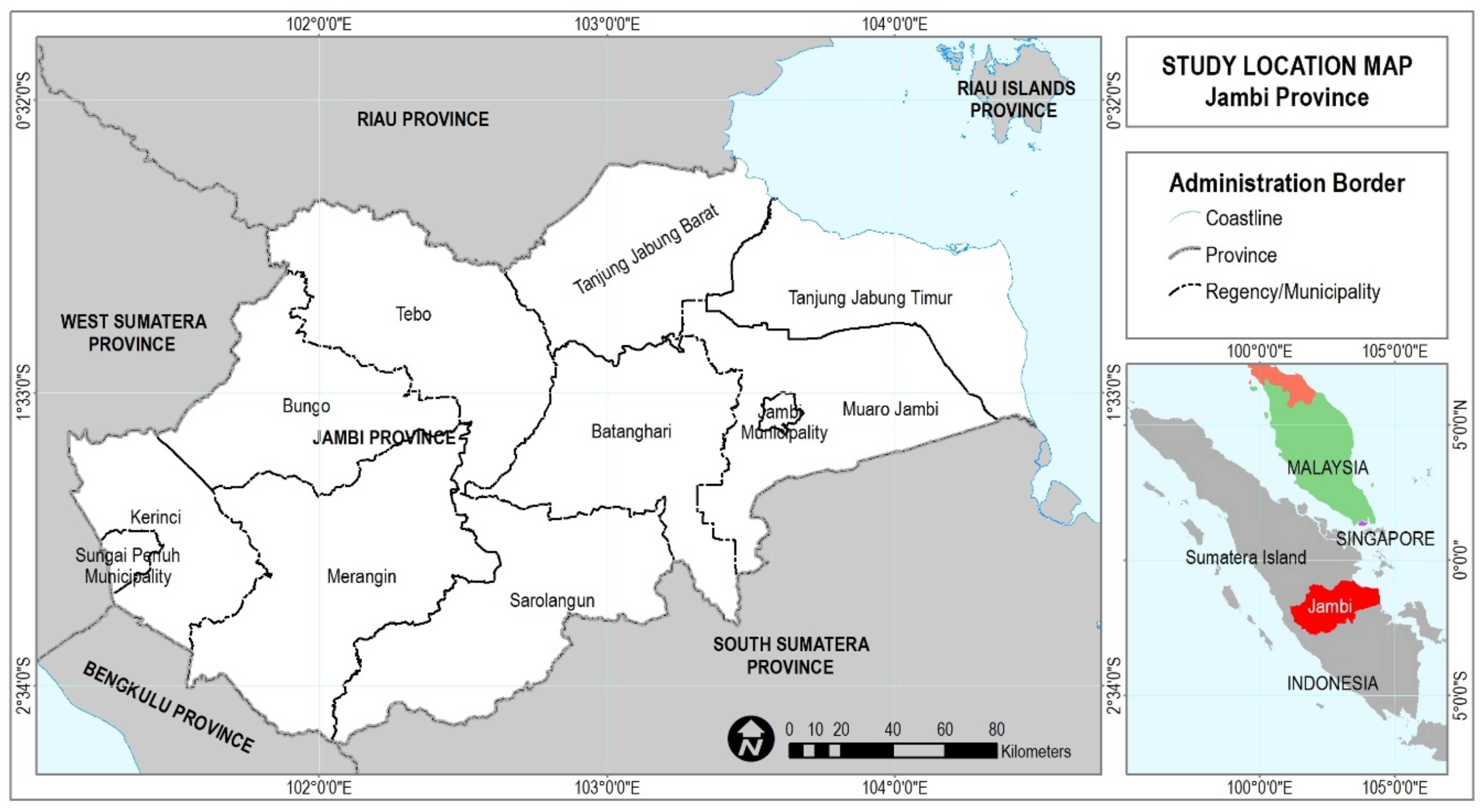
2.1. Study Area

This research was conducted in Jambi Province. This province is located on the east coast of central Sumatra Island, Indonesia (Figure 1). Administratively, Jambi Province consists of 2 cities (Jambi and Sungai Penuh Municipality) and 9 regencies (Bungo, Tebo, Tanjung Jabung Barat, Tanjung Jabung Timur, Muaro Jambi, Batang Hari, Sarolangun, Merangin, and Kerinci Regency). The total area is 50,160.05 km2, and the population in 2021 was 3,585,100 [50]. In building a rural typology, we used village data for two years, namely 2011 and 2020. Between these two years, the number of villages increased: based on Data Potensi Desa (PODES; Village Potential Data) released by Statistics Indonesia, the number of “desa” or villages (including urban villages, or “kelurahan”) was 1372 in 2011, increasing to 1562 in 2020.

2.2. Data Collection and Preparation

This study used secondary data for regional analysis. Data was collected on population, poverty rates, human development index (IPM), gross regional domestic product (GRDP) at constant and current prices, Gini index, and educational level. The data was collected at the provincial level and obtained from Statistics Indonesia and Statistics of Jambi Province. To analyze rural areas, we employed variables from PODES, collected by Statistics Indonesia in 2011 and 2020. PODES refers to regional data at the village level, including various indices, especially those related to village development. Land cover data for 2011 and 2020 was obtained from Crestpent (P4W), IPB University.

2.3. Methods

Jambi Province’s development progress was monitored at both the provincial level and the village level. At the provincial level, this analysis employed indicators that have been commonly used by both the government and academics. At the village level, we chronicled village progress by building an index based on infrastructure and economic activity. In addition, we also observed shifts in rural typology that occurred as a result of development.
Provincial development indicators will be discussed descriptively, including trends in the poverty rate (2002–2021), Gini index (2007–2021), HDI (2010–2021), GRDP per capita (2010–2021), level of education (2010–2015), sector-based GRDP (2010–2021), and land cover (2011 and 2020). For these data, we selected the initial year of 2010 because in previous years, there were changes in both measurement and categorization that led to inconsistencies in comparisons between years (e.g., [51,52]). Only the poverty rate can be reliably analyzed by starting closer to the year 2000.
To describe development progress at the village level, we propose an “economic diversity index” and an “infrastructure index”. Both are composed of variables obtained from PODES data. Variables representing the presence of economic activities and kinds of jobs were selected to build the diversity index. Meanwhile, data from PODES that can serve as proxies for infrastructure were extracted to build the infrastructure index. The full lists of the selected variables are shown in Supplementary Materials Files S1 and S2. The formulae for both the infrastructure and the economic diversity index are shown as follows;
I = i = 0 n x i
where I is the index value of a village and xi is the presence of infrastructure or economic activity i in the village. If an activity or infrastructure exists in the village, then the score becomes 1 (one). Otherwise, it is 0 (zero). The index is the accumulation of scores from the presence of many activities or infrastructure.
The diversity of economic activity reflects the variety of jobs available. It refers to economic transformation through diversification of the population’s income sources, especially in the secondary and tertiary sectors [53]. Higher economic diversity is generally positively associated with resilience and the speed of recovery from crises [54]. Although comparative advantage is still the basis for determining the main source of village economic growth, diversity of activities has been regarded as critical in recent years because it promotes economic stability [54,55]. The diversity of economic activities can also be an indicator of village economic maturity, namely that supply and demand have emerged for various kinds of products and services at the village level. The variety of infrastructure available in the villages is one of the factors showing the functional structure between locations, especially between the hinterland and core areas [56]. Areas with a higher variety of infrastructure are generally service centers for the surrounding area [57].
Next, we analyzed the shift of rural typology accompanying regional development. We performed a k-means cluster analysis [58] to create groups of villages. The variables included are shown in Table 1. K-means cluster analysis is a method often used in the field of regional planning to reveal the typology or organic characteristics of the area formed [48,49,59,60]. To observe the “shifts” in rural socio-economic conditions, the clustering was conducted for two different years: 2011 and 2020. The number of optimal clusters was determined using the silhouette method [61] and dendrogram interpretation.

3. Results

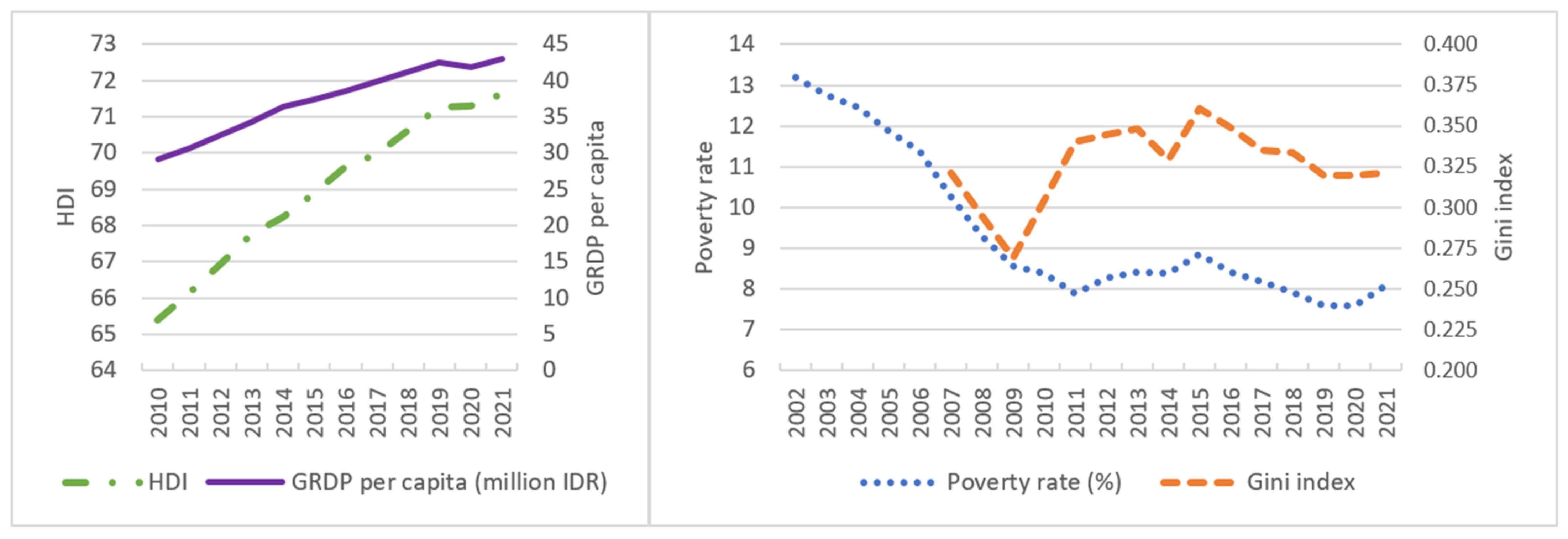
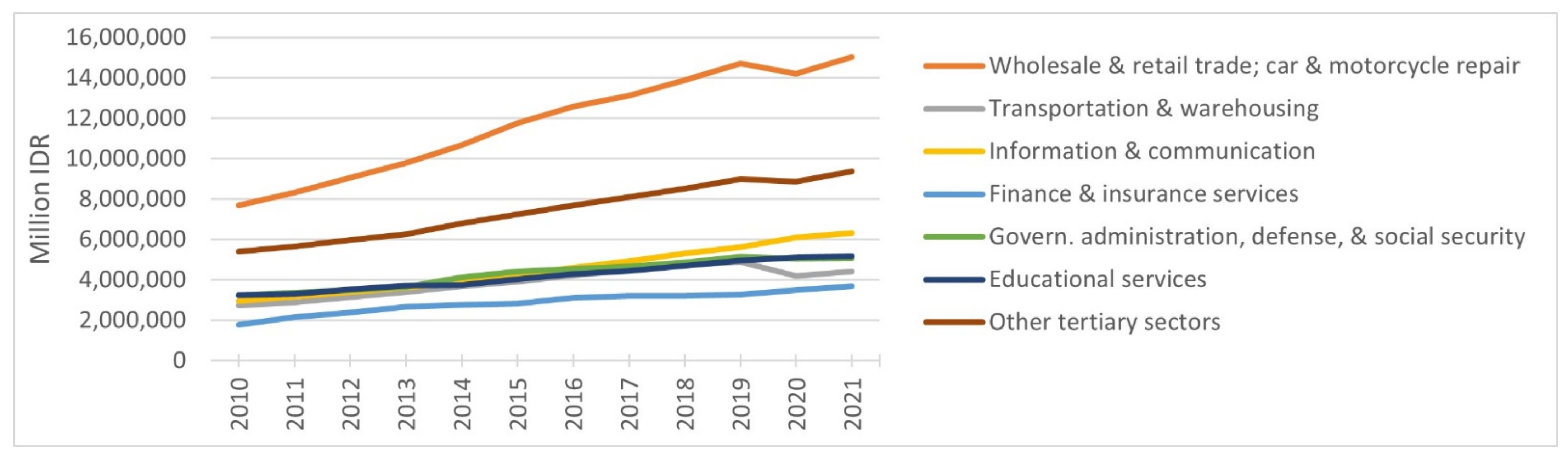
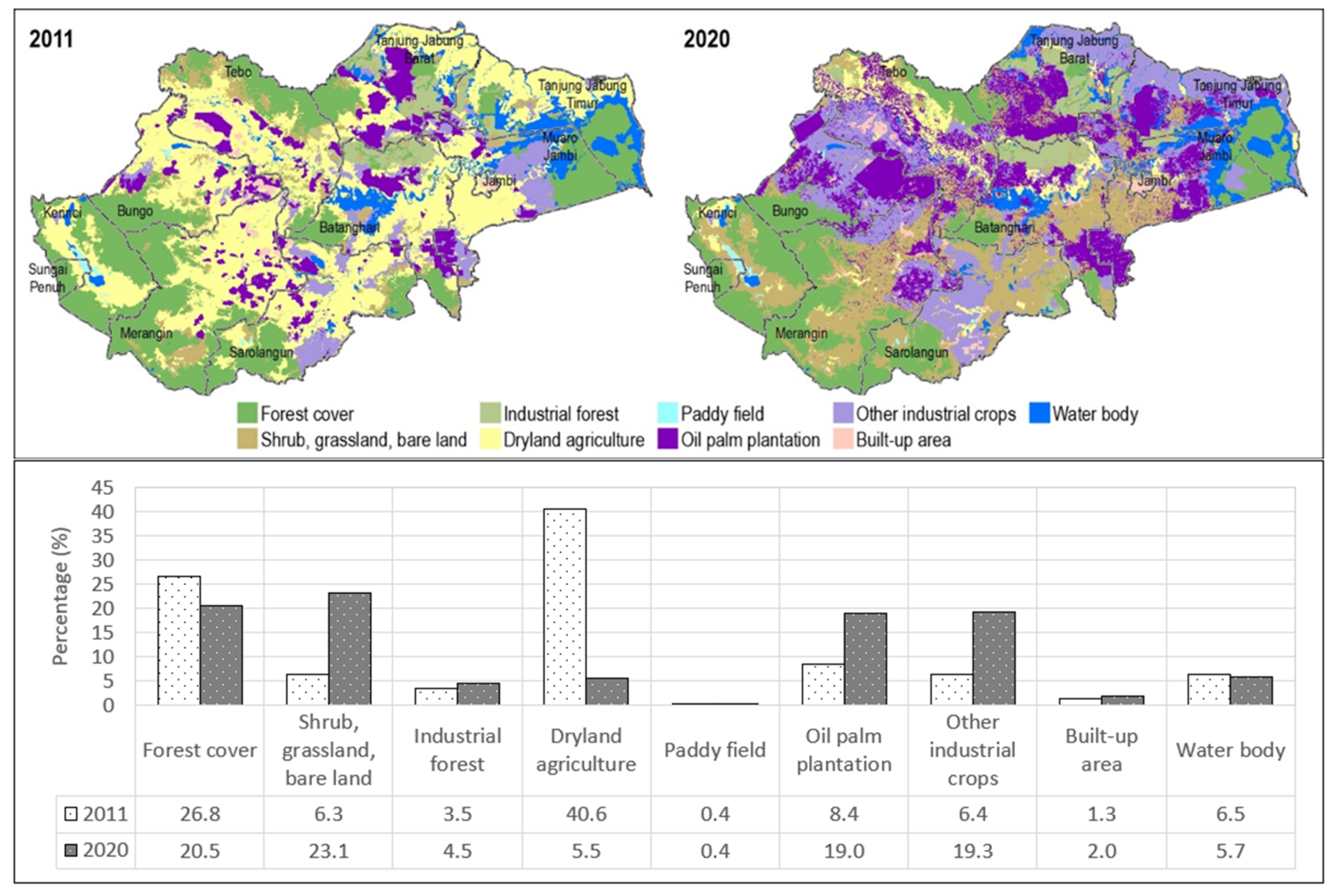
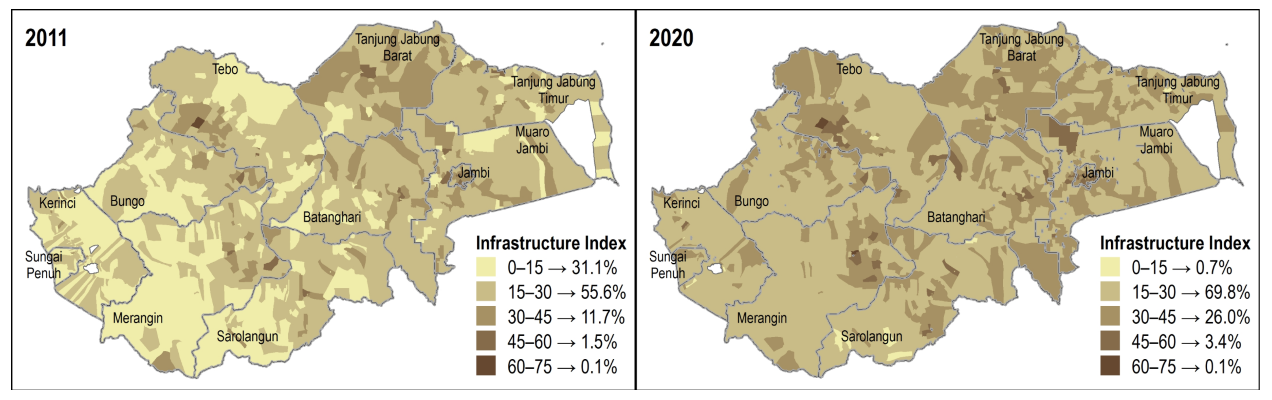
3.1. General Overview of the Development Progress

Jambi Province is one of 10 provinces on Sumatra Island. If viewed from a GRDP perspective over the past two decades, Jambi Province has generally not been in a superior position. In 2003, Jambi Province’s total GRDP was IDR 11.3 billion (constant price based on 2000), which placed the province in the 8th position out of 10 [62]. The province with the highest GRDP was North Sumatra Province, followed by Riau Province in second place. Until 2012, the position of the three provinces did not change, then Jambi Province rose to 7th by overtaking Aceh Province in 2013 and remained at that rank until 2021 [63].
However, Jambi Province has excelled in terms of GRDP growth. From 2003 to 2019, the average annual GRDP growth for this province was 5.99%, the highest rate in Sumatra [64,65]. The highest growth occurred between 2007 and 2013 when the average GRDP growth per year reached 7.1%. The COVID-19 pandemic had quite an impact on this performance, as economic growth was minus (−) 0.44% in 2019–2020 [65]. However, in the following year, Jambi’s economy grew again by 3.66%, the second highest after the Bangka Belitung Islands Province.
In terms of GRDP per capita, Jambi was securely in third place after the Riau Islands Province and Riau Province in 2010–2022 [66]. These top two provinces are resource-rich regions, especially in terms of crude oil [67] as well as palm oil production [35,68]. Jambi’s per capita GRDP grew steadily until 2019 (Figure 2). Growth distortions occurred in 2019–2020 due to the COVID-19 pandemic, as the GRDP per capita decreased, then increased again in 2020–2021. In the last decade, there has also been a shift in the GRDP structure. In 2010, the primary sector was still dominant, accounting for more than 50% of the total volume (Figure 3b). This share had shrunk to 46% by 2021. Notably, this decrease in relative share was not complemented by a rise in the secondary-sector contribution, as this sector’s share has remained stable at around 18% for the past decade. Instead, the share of the tertiary sector increased from 30% in 2010 to 36% in 2021. The increase in the contribution of the tertiary sector was largely driven by relatively constant growth in the trade and motorized-vehicle repair sectors (Figure 4).
Apart from the growth trend of GRDP per capita and structural shifts in the GRDP, the Jambi Province HDI also improved year to year (Figure 2). In 2010, Jambi’s HDI score was 65.4, and it continued to increase to reach 71.63 in 2021. One of the ways to develop Jambi’s human potential is to seek improvement in educational achievements. Figure 3a shows that the percentage of the population with only primary school education decreased from 2010–2015, as an increasing percentage of residents had obtained secondary and tertiary school diplomas. In a regional context, however, Jambi’s HDI does not appear to be very competitive when compared to other provinces in Sumatra. In 2006, Jambi was ranked 5th [69]; however, during the following years until 2021, Jambi’s HDI only ranked 7th or 8th.
The increase in GRDP, the share of the tertiary sector, and the HDI over the past decade did not seem to have a direct relationship with the reduction in the Gini index and the poverty rate. Even though there was a downward trend in the Gini index and the poverty rate from 2015 to 2020, this pattern seemed to fluctuate during the longer period from 2010 to 2020. In 2021, there was a rise in the percentage of those under the poverty line, which seemed to be due to changes in patterns of economic activity that occurred during the COVID-19 pandemic [70].
Progress in development in Jambi Province can also be seen by observing changes in the province’s land cover. Initially, in 2011, forest land cover and dryland agriculture were still very dominant in Jambi (Figure 5): forest cover accounted for 26.8%, while 40.6% of the land was dryland agriculture. Dryland agriculture in Jambi Province is dominated by seasonal crops with lower productivity than industrial plantation crops. However, in 2020, forest cover and dryland agriculture shrank to 20.5% and 5.5%, respectively. The decline in land cover is inseparable from the government’s policy to ease the provision of plantation business licenses in Jambi Province, especially for oil palm and rubber. Accordingly, from 2003–2020 there was a sizable increase in oil palm plantations and other industrial crop plantations. The share of oil palm plantation land rose from only 8.4% in 2011 to 19% in 2020 (see also [42]). Other types of plantations also increased in volume, from 6.4% in 2011 to 19.3% in 2020.
Most of the oil palm plantations as of 2020 were in Bungo, Muaro Jambi, and West Tanjung Jabung Regency. These three regencies account for more than 50% of the land occupied by oil palm plantations in Jambi Province. Among them, according to the Directorate General of Estate Crops [71], Muaro Jambi is the regency with the highest production level, with a total area and production volume of 125,888 hectares and 244,057 tons, respectively, in 2019. Significant increases in oil palm land over the past decade have also occurred in Bungo and Muaro Jambi. The expansion of oil palm plantations is related to land-use conversion from other land utilization and deforestation, [26,72] which in some areas affected primary forest [42].
Jambi Province ranked fourth in 2020 among provinces in Sumatra in terms of cultivation area of oil palm, at around 1.08 million hectares, and crude palm oil (CPO) production of approximately 2.55 million tons [73]. In Jambi, oil palm plantations are expanding due to both land suitability and financial feasibility [74,75,76]. Due to its high productivity, palm oil is currently one of the leading commodities in Jambi Province and has been recognized as a primary source of regional income [77]. It contributes considerably to regional GDP and generates substantial income for farmers as well as job opportunities for non-agricultural households [74,75,76]. Moreover, oil palm cultivation produces higher profits than other agricultural businesses, including rubber cultivation, in Jambi [74].
Land used for plantations other than oil palm are concentrated in the regencies of East Tanjung Jabung, Sarolangun, and Bungo, which account for more than 50% of all non-oil palm plantations. Bungo is the dominant regency in both oil palm plantations and other plantations. Some land cover types, other than plantations, have also expanded. The increase in shrub, grassland, and bare land is quite striking. This seems to be caused by a change in the pattern of community agricultural activities from dryland farming to plantations, causing some agricultural land to be abandoned. Changes in forest cover also contributed to the increase in shrub, grassland, and bare land. Industrial forestry activities also appear to be expanding in Jambi. The greatest increase in the intensity of industrial forestry activities occurred in West Tanjung Jabung Regency, followed by Batang Hari and Tebo.

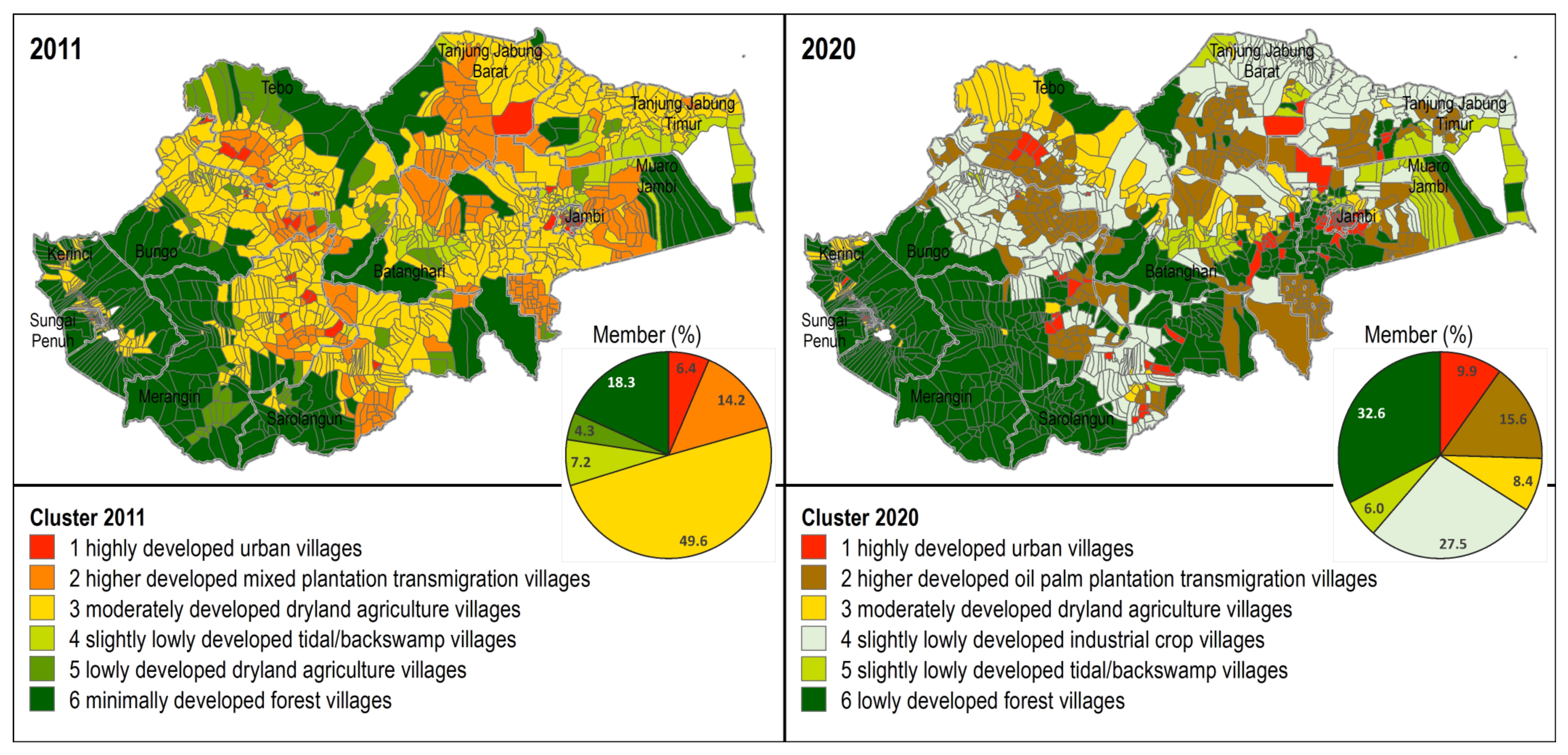
3.2. Development Progress at Village Level

Development progress in Jambi Province has been marked by improved economic conditions (notably with more diverse sources of income) and infrastructure in rural areas. Figure 6 shows that areas marked in dark red in 2022 increased when compared to dark red areas in 2011. This shows growing variation in people’s sources of income at the village level. In 2011, villages with a diversity index of 20–40 accounted for 71.7%, and those with a 40–60 value only accounted for 16.6%. In 2020, however, the value of diversity in both of these categories had shifted to 53.1% and 42.7%, respectively. In other words, there has been a decline in the percentage of villages with an index value of less than 40, and, conversely, an increase in the number of villages with an index value of more than 40. Villages with a 0–20 score decreased from 9.5% in 2011 to 0.4% in 2020.
The diversity of community economic activity is an important indicator of the development of rural areas in Indonesia. The limited types of income sources for rural communities force residents to work exclusively in the agricultural sector or sectors that exploit local natural resources [70,78]. Villages that only depend on resource exploitation tend to experience regional leakage [79,80], namely direct or indirect expenditure by households or industries outside the area of origin [81]. Increased diversity of economic activities encourages a balance of supply and demand for various products and services so as to minimize economic leakage from rural areas. [82].
The number of infrastructure types in rural areas also increased in the last decade. In 2011, villages with an index below 15 accounted for 31.1% (Figure 7). Most of these villages were in the Merangin, Tebo, Bungo, and Kerinci regencies, especially in less populated villages located near mountains that were generally not traversed by main routes between regions. In the same year, 55.6% of the villages recorded a score of 15–30, while only 13.3% had a score above 30. In 2020, the share of villages with an index of 0–15 shrank to only 0.7%, while 69.8% of the villages were at 15–30 and 29.5% of the villages had scores over 30.
As with economic diversity, the number of infrastructure types is also related to local supply–demand relationships. Therefore, an increase in the amount of infrastructure basically reflects the purchasing power of local residents. An increase in purchasing power will typically be followed by a rise in the volume of certain products or services. Infrastructure has shown an increase in both number and type in most regions [83]. However, the concentration of infrastructure generally only occurs in a few places which are service center villages [84]. Usually, but not always, the capital of a kecamatan (sub-district) becomes the service center for other villages in the same sub-district; that is why villages with high index scores were likely to exhibit little change between 2011 and 2020 (Figure 7).

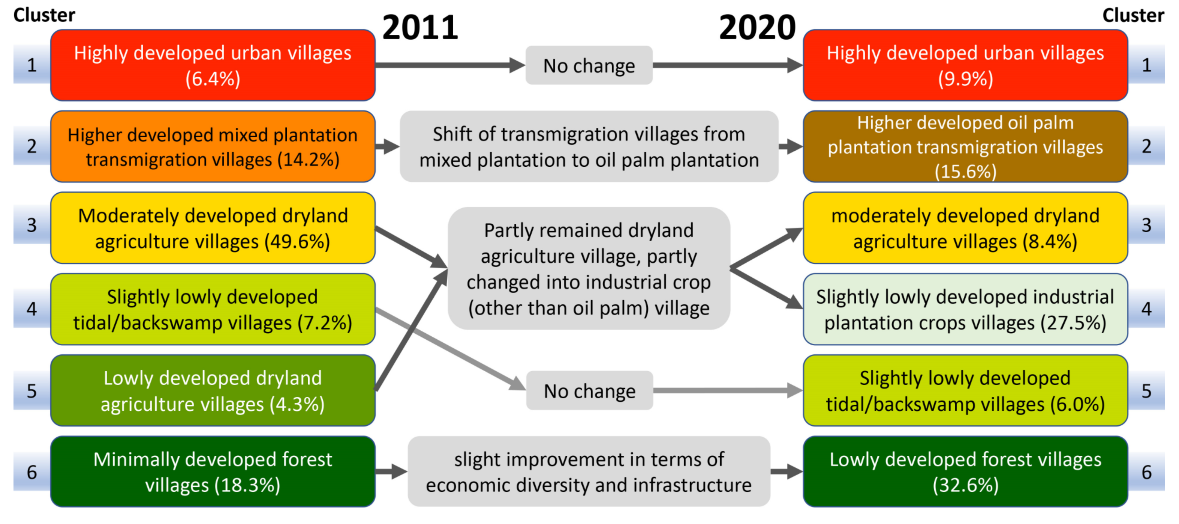
3.3. The Shift in Typology of Rural Areas

Cluster analysis was carried out to identify the typology of villages that were formed organically in Jambi Province. The analysis was performed for two different years to elucidate how shifts have occurred amid the dynamics of development in the last decade. Silhouette analysis, which was carried out to identify the optimal number of clusters each year, resulted in a value of 6, indicating that we could produce 6 clusters of villages for both 2011 and 2020. Figure 8, Table 2, and Figure 9 show the results of the cluster analysis for each year. In general, all variables involved in the cluster analysis were decisive in differentiating 1 or 2 clusters from others (Figure 8). The variable that proved to be least useful in differentiating the clusters was Ethnic20, which seemed to have more or less the same level among the clusters.
In 2011, Cluster 1 displayed characteristics of urban villages or villages that became the local centers for the surrounding villages. This can be indicated by the percentage of built-up land, which is higher than other villages, as well as the very high economic diversity index and infrastructure index values. Villages like these are generally urban villages and are not destination locations for transmigrants. It is in these villages that a high diversity of economic and infrastructure activities occurs.
Cluster 2-2011 (cluster 2 from cluster analysis results of 2011 data) was composed of villages with a dominant plantation landscape, both oil palm plantations and other annual crop plantations. Villages with this landscape are predominantly transmigration villages—initially, the planned activities in the transmigration areas centered on food crop production. However, due to poor soil fertility, food crop land was converted into plantations, both community- and corporate-based [85]. The villages that carried out this activity earlier were the transmigration villages [22,86,87]. Another feature of Cluster 2-2011 is the high index of economic diversity and infrastructure. In 2011 14.2% of villages in Jambi Province had this typology.
Cluster 3-2011 included non-transmigration villages whose landscapes were dominated by dryland agriculture. The economic diversity index and the infrastructure of the villages in this cluster tended to be medium-level. Villages with this typology were very dominant in 2011, accounting for 49.6% of villages in Jambi Province. Cluster 4-2011 was villages that were located around water bodies, swampland, or tidal lands, indicated by a high degree of water body cover. Some of the rural areas of Jambi did have swamps and tides, especially villages on the east coast of Jambi Province. The typology of these villages has become very distinctive and appears as a separate cluster. Clusters 5-2011 and 6-2011 were villages that were in the proximity of mountains or hilly areas. This was marked by high levels of forest cover. The economic and infrastructure diversity indexes for the two clusters were also low.
If village typologies in 2011 are compared to those in 2020, some shifts can be identified, as shown in Figure 10. Cluster 1-2020 was for villages with the same characteristics as Cluster 1-2011, namely urban villages. The percentage of villages with this condition increased from 6.4% in 2011 to 9.9% in 2020. Cluster 2-2020 was for transmigration villages. Unlike in 2011, the landscape of the villages of Cluster 2-2020 was dominated by oil palm plantations. The economic diversity index and infrastructure index of these villages were also quite high, ranked second after urban villages.
Cluster 3-2020 was similar to Cluster 3-2011: a high share of dryland and agricultural land cover, and a medium level of economic diversity and infrastructure index. One emerging trend was the appearance of land cover for oil palm plantations and other plantations, although the amount was still relatively low in percentage terms. Cluster 4-2020 was a newly emerging typology, namely villages that came to feature plantations other than oil palm. These villages were generally not formerly part of the transmigration program, and their diversity index and infrastructure index scores tended to be rather low. Finally, the characteristics of Cluster 5-2020 and Cluster 6-2020 were seemingly the same as those of Cluster 4-2011 and Cluster 6-2011, respectively.

4. Discussion

4.1. Development Progress at Provincial and Local Levels

The progress of regional development in Jambi Province can be seen from both internal and regional perspectives. Applying internal perspectives, Jambi Province’s development indicators show a positive trend. HDI, GRDP, and GRDP per capita are increasing. There has been an increase in the quality of human resources based on educational levels. A shift in the economic structure has also occurred, from dominance by the agricultural sector to that of the non-agricultural sector. Even though the GRDP was distorted during the COVID-19 pandemic, it has resumed positive growth since then. However, it should be noted that the poverty rate and Gini ratio showed fluctuation during the years from 2010 to 2021. Basically, there was a pattern of decline between 2015 and 2020, but increases in 2020–2021, probably due to the impact of the COVID-19 pandemic.
From a regional perspective, Jambi Province’s economic performance is not especially prominent, as its GRDP only ranks 7th in 2021 out of 10 provinces in Sumatra. Nonetheless, Jambi’s annual GRDP growth has been the highest among regencies since 2003. Jambi Province’s GRDP per capita is also robust, placing it in third place after two provinces, Riau Islands and Riau, whose economies are supported by petroleum. In terms of HDI, however, Jambi has had less success, reaching only the 7th or 8th position.
The diversity of economic activities and the number of types of facilities (infrastructure) at the village level (including urban villages) is increasing. In the context of rural Indonesia, this diversity is regarded as an important indicator of village progress for two reasons. The first is the population, which continues to grow every year. The second issue is the need to increase sources of income for the population, as the agricultural sector has not proven able to absorb a sufficient number of young rural workers. Non-agricultural activities as an alternative source of income are required.

4.2. Policies Inducing Development Progress

At least three policies can be considered key to transforming the development of Jambi Province over the last few decades. The first policy was the designation of parts of Jambi’s rural areas as transmigration destinations, which served to focus the attention of the central government on the situation of rural areas of Jambi province. As a result, the central government provided support in the form of providing agricultural facilities and infrastructure, building roads, and improving basic services such as health and education. Thus, new service centers were formed at the local level, which slowly became an engine of local growth [32]. As of 2015, in the national aggregate data, 104 transmigration settlements have become regency or municipality capitals, 383 have become sub-district capitals, and 1183 out of 3055 transmigration settlements have become administratively autonomous villages [86]. Initially, in Jambi, there was a risk of social conflict. This is because land management approaches prior to 1998 tended to privilege transmigration villages, promoting a clash of interests between transmigration villages and indigenous resident villages. The implementation of the decentralization system in the early 2000s reduced the central government’s engagement with the transmigration program [14], but according to Prihatin [38], this also spurred regional transformation towards inclusive development, marked by greater recognition of the interests of non-transmigration villages and greater convergence between transmigration villages and indigenous resident villages.
The second policy was the construction of the Batanghari I Bridge (sometimes referred to as the Aurduri I Bridge) as part of the East Trans-Sumatra Highway project. Prior to 1986, the eastern side of Jambi province, including the provincial capital of Jambi, was not traversed by land trade routes between provinces. This is because the broad Batanghari River cleaves the eastern side of Jambi province into north and south. At that time, transportation routes across Sumatra were only on the central and western sides of the island. The Central Trans-Sumatra Highway crosses Sarolangun, Merangin, and Bungo regencies, but the West Trans-Sumatra Highway did not enter Jambi province. The construction of the Batanghari I Bridge in 1986 (to support the realization of the East Trans-Sumatra Highway) erased transportation barriers and succeeded in connecting Jambi City and its surrounding regency with cities in other provinces, such as Pekanbaru, Kuala Tungkal, Medan, and Banda Aceh [88]. With the presence of the East Trans-Sumatra Highway, the eastern side of Jambi Province is now well integrated with inter-provincial trade routes.
The third policy was licensing for plantation activities in Jambi Province. This policy has become quite controversial with many critics as well as supporters. Nevertheless, it has undeniably had a great impact on land cover in Jambi [89] and socio-economic conditions in rural areas. The massive expansion of plantations in Jambi Province, especially oil palm plantations, has attracted the attention of many scholars, who have raised concerns such as loss of biodiversity, air and water pollution [90], the local climatic implications of oil palm plantations [89,91,92], expansion into tidal land which threatens ecosystem damage [36], land conflicts between companies and local residents [27], impoverishment of oil palm smallholders [93,94,95], and other impacts.
Despite the controversy, the development of oil palm plantations has brought economic benefits to many rural communities in Jambi, including job opportunities and increased income. For example, it has induced high absorption of regional labor—in the case of Muaro Jambi Regency, labor absorption reached 28.41% [96]—and has provided a multiplier effect for GRDP [97]. Mara and Fitri [97] found that every increase in income in the palm oil sector of IDR 1 (Indonesian rupiah) will result in an increase in the village’s GRDP of IDR 1.417. The industry has also spurred infrastructure development, such as roads and schools, and contributed to government revenue through taxes and export earnings. This has helped to improve living standards for many people in these areas.
Another finding in our study is that the share of the secondary sector remained relatively constant over the period of analysis, at around 18%. Jambi Province currently appears relatively unattractive as a manufacturing industry center due to its small population, low population density, and low educational levels. Considering the extent of the expansion of plantation land, this may be cause for concern. This shows that even though growth has been driven by the expansion of oil palm plantations, the downstream impacts of this production are still limited. Palm processing is limited to the production of crude palm oil [98]. Ramadhan et al. [99] performed input–output analysis that found that the backward direct effect of the CPO industry was 0.3792, while the forward direct effect only reached 0.0090 (see also [100]). In other words, the CPO industry has not been able to spur growth in the processing and manufacturing sectors [40]. Meanwhile, a relative decline in the primary sector was balanced by an increase in the tertiary sector. In the last few decades, the growth of local demand has driven the expansion of the tertiary sector, especially in terms of the trade and motorized-vehicle repair sectors.

4.3. The Shift in Village’s Characteristics

The macro policies mentioned in Section 4.2 and the progress that followed, have spurred typological transformations in rural areas. In general, village typology in Jambi Province varies from upland to lowland. Several typological shifts can be highlighted. First, development activities have increased the number of villages with urban characteristics. Some of the villages that were previously not characterized as having urban conditions turned into urban villages and might become new service centers for surrounding villages. Urbanization processes like this are common in rural areas of developing countries [101].
More significantly, a striking trend in village transformation was revealed with the concentration of oil palm plantations in transmigration villages and other industrial plantations in some non-transmigration villages. Initially, these villages were characterized by a mixed land scheme combining plantation land cover and dryland agriculture. The concentration of oil palm plantations in transmigration villages was promoted by various government-backed schemes, such as PIR-Trans and PIR-NES, that favored transmigration villages in providing training, seedlings, and other inputs to which non-transmigrants had reduced or delayed access. PIR (Perkebunan Inti Rakyat) was a mutually beneficial, widely sustainable program that featured the development of newly opened land with a core (“nucleus”) company-run plantation area and surrounding smallholders’ plantations (known as “plasma”) [102]. Nucleus Estate and Smallholders (NES) was a PIR program that involved financing from the World Bank. PIR-Trans emerged when PIR was combined with the transmigration program through the enactment of Inpres (Instruksi Presiden or President Directive) No. 1 of 1986. Other factors may have contributed to the concentration of oil palm production in transmigration villages as well. For example, oil palm production requires capital and the ability to wait until the trees mature, which made it less attractive to local residents who had already developed alternative subsistence income sources such as traditional rubber cultivation or local labor networks. In addition, the transmigrants tended to be young, hard-working, and ambitious, so were be more likely to take on more economic risk than local Malays [27].
To sum up, in 2011, the village typologies in Jambi Province included (1) highly developed urban villages, (2) higher developed mixed plantation transmigration villages, (3) moderately developed dryland agriculture villages, (4) slightly lowly developed tidal/backswamp villages, (5) lowly developed dryland agricultural villages, and (6) minimally developed forest villages. Several typological shifts occurred from that time until 2020, in which many transmigration villages became predominantly oil palm plantation villages. Meanwhile, some of the non-transmigration villages changed from dryland farming to plantation cultivation for industrial crops other than oil palm. Thus, the village typologies in 2020 were as follows: (1) highly developed urban villages, (2) higher developed oil palm plantation transmigration villages, (3) moderately developed dryland agriculture villages, (4) slightly lowly developed industrial crop villages, (5) slightly lowly developed tidal/backswamp villages, and (6) lowly developed forest villages.

5. Conclusions

Over the last two decades, the development indicators in Jambi Province have shown positive trends, including increases in the HDI, GRDP, GRDP per capita, and the percentage of the tertiary sector in the GRDP structure. The increase in the tertiary sector was largely driven by the trade and motorized-vehicle repair sectors. The Gini index and the poverty rate have shown a downward trend since 2015. From an inter-provincial perspective, Jambi is less competitive when compared with other provinces in Sumatra in terms of HDI and GRDP. However, Jambi’s economic growth has been the highest in the last two decades compared to the other provinces. Jambi’s GRDP per capita is also quite competitive, in third place after the Riau Islands and Riau. At the village level, development progress in Jambi Province has been accompanied by an increase in the diversity of economic activities and infrastructure. The distribution of this increase is also quite even.
Regional development and rural transformation have coincided with land use/cover changes in Jambi province. From 2011–2020, rural transformation took place in at least three forms. First, economic development was characterized by increased per capita income, availability of infrastructure, reduced poverty rates, diversification of economic activities, and increasing activity of the secondary and tertiary sectors in rural areas, followed by a trend of increasing economic inequality. Apart from the trend of urbanization and a decline in the number of dryland food crop villages, rural development was marked by increasing polarization between more developed villages depending on oil palm and other industrial tree plantations (43.1%), on the one hand, and relatively underdeveloped villages near forests and wetlands (38.6%), on the other. Second, as can be seen from the pattern of changes in land cover/use, there is a trend of ongoing deforestation and conversion from food crop agricultural activities to agricultural activities which are dominated by monoculture plantations of industrial crops, especially oil palm. Third, demographically, there has been a shift in the ethnic composition of the population from local Malay ethnic domination to a mixture of local ethnicities and Javanese transmigrant residents, followed by increasing ethnic diversity due to more migrants being attracted to oil palm plantations.
In conclusion, urbanization has occurred in Jambi, as shown by the increase in the number of members in the highly developed urban village typology. Village transformation occurred in transmigration villages, which were originally higher developed mixed plantation transmigration villages in 2011 but became higher developed oil palm plantation transmigration villages by 2020. Transformation also occurred in the villages of two typology groups in 2011: moderately developed dryland agriculture and slightly lowly developed tidal/backswamp villages. Most of these two types of villages transformed into slightly lowly developed industrial plantation crops villages, while a few remained moderately developed dryland agriculture villages in 2020. Slightly lowly developed tidal/backswamp villages remained unchanged, while villages around forest experienced an increase in village quality from minimally developed to lowly developed.
These trends suggest that the government consider adopting several new policies. The first is to control changes in land use/cover related to the expansion of oil palm plantations, deforestation, and conversion of food land, in order to maintain biodiversity and promote integrated farming. Secondly, the province should seek to expand new economic business options outside of oil palm in rural areas, including growing secondary and tertiary sector activities in rural areas, such as agroindustry and rural tourism. Thirdly, the government should promote the economy of local indigenous communities, including capacity-building programs for human resources and local community institutions. One contribution of this research is its detailing of the processes by which the central government’s transmigration and plantation development programs have caused deforestation and rapid expansion of oil palm plantations in almost all areas of Jambi province, as well as impacting the transformation and polarization of rural area development and the regional economy.
This research has several limitations, including socio-economic data that rely on secondary data, especially PODES data. The addition of reliable secondary and primary data can improve the accuracy of the description and improve related policy formation. Research on developing analytical methods that support constraints on oil palm plantation expansion and resulting deforestation is needed. Moreover, there is an urgent need for more action research, such as developing new alternative livelihoods, promoting human resources, and building institutional capacity in rural areas.

Supplementary Materials

The following supporting information can be downloaded at: https://www.mdpi.com/article/10.3390/land12051059/s1, File S1: variables of diversity index); File S2: variables of infrastructure index.

Author Contributions

Conceptualization, E.R., A.E.P. and R.A.P.; data curation, R.A.P. and R.I.S.; formal analysis, R.A.P.; funding acquisition, A.E.P., E.R., J.J. and Z.Z.; methodology, E.R., A.E.P. and R.A.P.; investigation, E.R., A.E.P., J.J., Z.Z., R.A.P. and J.S.; supervision, E.R., A.E.P., J.J. and Z.Z.; visualization, R.A.P. and A.E.P. writing—original draft, R.A.P.; writing review and editing, R.A.P., E.R., A.E.P. and J.S. All authors have read and agreed to the published version of the manuscript.

Funding

This research and the APC were funded by Indonesia Endowment Funds for Education (LPDP): 4009/IT3.L1/PT.01.03/M/T/2022.

Data Availability Statement

Population, Gini index, education level, HDI, and GRDP can be downloaded from https://jambi.bps.go.id/ (accessed on 6 May 2023) and https://www.bps.go.id/ (accessed on 6 April 2023). Land cover and Village Potential Data 2011 and 2020 are available upon request to the corresponding author.

Conflicts of Interest

The authors declare no conflict of interest. The funder had no role in (a) the design of the study; (b) the collection, analyses, or interpretation of data; (c) the writing of the manuscript; or (d) the decision to publish the results.

References

  1. Chigbu, U.E. Ruralisation: A Tool for Rural Transformation. Dev. Pract. 2015, 25, 1067–1073. [Google Scholar] [CrossRef]
  2. Huang, J. Facilitating Inclusive Rural Transformation in the Asian Developing Countries. World Food Policy 2018, 4, 31–55. [Google Scholar] [CrossRef]
  3. Stecklov, G.; Menashe-Oren, A. The Demography of Rural Youth in Developing Countries; IFAD: Rome, Italy, 2019. [Google Scholar] [CrossRef]
  4. Ward, N.; Brown, D.L. Placing the Rural in Regional Development. Reg. Stud. 2009, 43, 1237–1244. [Google Scholar] [CrossRef]
  5. Wilonoyudho, S.; Rijanta, R.; Keban, Y.T.; Setiawan, B. Urbanization and Regional Imbalances in Indonesia. Indones. J. Geogr. 2017, 49, 125–132. [Google Scholar] [CrossRef]
  6. Myrdal, G. The Drift towards Regional Economic Inequalities in a Country. In Economic Theory and Underdeveloped Regions; Duckworth Books: London, UK, 1957; pp. 23–38. [Google Scholar]
  7. Mustapa, I.; Sumarmo; Setiawan, B.; Pramoedyo, H. Impact of Rural Area Development in Driving Regional Growth of Bone Bolango Regency: Case Study of “Desa Tumbuh Daerah Maju. Italienisch 2022, 12, 885–892. [Google Scholar]
  8. Rustiadi, E.; Saefulhakim, S.; Panuju, R.D. Perencanaan Dan Pengembangan Wilayah, 2nd ed.; Pravitasari, A.E., Ed.; Crespent Press & Yayasan Pustaka Obor Indonesia: Jakarta, Indonesia, 2011. [Google Scholar]
  9. Agunggunanto, E.Y.; Arianti, F.; Kushartono, E.W.; Darwanto. Pengembangan Desa Mandiri Melalui Pengelolaan Badan Usaha Milik Desa (BUMDES). J. Din. Ekon. Bisnis 2016, 13, 67–81. [Google Scholar] [CrossRef]
  10. Haider, L.J.; Boonstra, W.J.; Peterson, G.D.; Schlüter, M. Traps and Sustainable Development in Rural Areas: A Review. World Dev. 2018, 101, 311–321. [Google Scholar] [CrossRef]
  11. Pravitasari, A.E.; Rustiadi, E.; Singer, J.; Fuadina, L.N. Developing Local Sustainability Index (LSI) at Village Level in Jambi Province. In International Proceeding of the 8th Rural Research and Planning Group International Conference, Yogyakarta, 16–17 May 2017; Suratman, Baiquni, M., Hasanati, S., Eds.; Gadjah Mada University Press: Yogyakarta, Indonesia, 2018; pp. 15–29. [Google Scholar]
  12. International Labour Office. Unleashing Rural Development through Productive Employment and Decent Work: Building on 40 Years of ILO Work in Rural Areas. In Proceedings of the ILO Committee on Employment and Social Policy, 310th Session, Geneva, Switzerland, 21 February 2011. [Google Scholar]
  13. Kementerian Desa Pembangunan Daerah Tertinggal dan Transmigrasi. Rencana Strategis Kementerian Desa, Pembangunan Daerah Tertinggal Dan Transmigrasi 2020–2024; Kemendes PDTT: Jakarta, Indonesia, 2020.
  14. Potter, L. New Transmigration ‘Paradigm’ in Indonesia: Examples from Kalimantan. Asia Pac. Viewp. 2012, 53, 272–287. [Google Scholar] [CrossRef]
  15. Junaidi. Transmigration In Jambi Province from the Perspective of Regional Policymakers. Jambura Agribus. J. 2022, 4, 13–22. [Google Scholar] [CrossRef]
  16. Rodríguez-Pose, A.; Hardy, D. Addressing Poverty and Inequality in the Rural Economy from a Global Perspective. Appl. Geogr. 2015, 61, 11–23. [Google Scholar] [CrossRef]
  17. Rodiyah. Reformation of the Administration of Village Government in Indonesia Based on Law Number 6 of 2014 on Villages (Comparing Normative and Empirical Facts on Villagers Participation). In Proceedings of the 1st International Conference on Indonesian Legal Studies (ICILS 2018), Semarang, Indonesia, 25 July 2018; Rodiyah, Suhadi, Anitasari, R.F., Muhtada, D., Arifin, R., Eds.; Atlantis Press: Amsterdam, The Netherlands, 2018; pp. 264–269. [Google Scholar] [CrossRef]
  18. Saadah, M.; Sampoerno, M.N.; Triansyah, Z.; Chaniago, F. Pengembangan Pengelolaan Pariwisata Oleh Badan Usaha Milik Desa Di Jambi. KAMBOTI J. Ilmu Sosial. Hum. 2021, 1, 182–192. [Google Scholar] [CrossRef]
  19. Pamungkas, B.A. Pelaksanaan Otonomi Desa Pasca Undang-Undang Nomor 6 Tahun 2014 Tentang Desa. J. USM Law. Rev. 2019, 2, 210. [Google Scholar] [CrossRef]
  20. Vel, J.A.C.; Bedner, A.W. Decentralisation and Village Governance in Indonesia: The Return to the Nagari and the 2014 Village Law. J. Leg. Plur. Unoff. Law 2015, 47, 493–507. [Google Scholar] [CrossRef]
  21. Anshari, K. Indonesia’s Village Fiscal Transfers (Dana Desa) Policy: The Effect on Local Authority and Resident Participation. J. Studi Pemerintah 2018, 9, 619–653. [Google Scholar] [CrossRef]
  22. Soekasdi. Selayang Pandang Proyek Transmigrasi Jambi; Soekasdi: Jambi, Indonesia, 1980. [Google Scholar]
  23. Praja, S.W.; Pratama, M.R.B. Transport Management in Rural Areas to Improve Road Safety User. In IOP Conference Series: Earth and Environmental Science; IOP Publishing: Bristol, UK, 2022; Volume 1092, p. 012008. [Google Scholar] [CrossRef]
  24. Aprilianti, V.; Harkeni, A.; Andriany, E.; Bahri, Z. Paper Technical Efficiency of Infrastructure Spending Nexus Unemployment of District/Municipalities in Province of Jambi. In Proceedings of the International Conference on Industrial Engineering and Operations Management, Harbin, China, 9–11 July 2021; Ali, A., Linton, A.L., Eds.; IEOM Society: Southfield, MI, USA, 2021; pp. 609–619. [Google Scholar]
  25. Achmad, E. Analysis of Industrialization and Economic Growth in Jambi Province. In Malaysia Indonesia International Conference on Economics, Management and Accounting (MIICEMA) 2016, Jambi, Indonesia, 24–25 October 2016; Junaidi, Johannes, Yacob, S., Lubis, T.A., Rahayu, S., Eds.; Faculty of Economics and Business, University of Jambi: Jambi, Indonesia, 2016. [Google Scholar]
  26. Rustiadi, E.; Mulya, S.P.; Pribadi, D.O.; Saad, A.; Supijatno; Iman, L.O.S.; Pravitasari, A.E.; Ermyanyla, M.; Nurdin, M. Study of Oil Palm Plantation on Peatland under Spatial Policies in Jambi Province, Indonesia. In IOP Conference Series: Earth and Environmental Science; IOP Publishing: Bristol, UK, 2022; Volume 1025, p. 012004. [Google Scholar] [CrossRef]
  27. Steinebach, S. “Today we occupy the plantation—Tomorrow Jakarta”: Indigeneity, land and oil palm plantations in Jambi. In Adat and Indigeneity in Indonesia; Hauser-Schäublin, B., Ed.; Universitätsverlag Göttingen: Göttingen, Germany, 2013; pp. 63–79. [Google Scholar]
  28. Suprianto, D.; Effendi, I.; Budiardi, T.; Widanarni; Diatin, I.; Hadiroseyani, Y. Evaluation of Aquaculture Development in the Minapolitan Area of Merangin Regency, Jambi Province, Indonesia. AACL Bioflux 2021, 14, 1282–1294. [Google Scholar]
  29. Jamal, H. Pola Dan Prospek Pengembangan Ternak Kambing Di Kawasan Agropolitan Kecamatan Kumpeh Ulu Kabupaten Muaro Jambi Provinsi Jambi. In Proceedings of the Seminar Nasional Hasil Penelitian/Pengkajian Spesifik Lokasi, Jambi, Indonesia, 23–24 November 2005; Peran, Teknologi Pertanian dalam Mendukung Revitalisasi Pertanian di Provinsi Jambi. BPTP: Jambi, Indonesia, 2006; pp. 490–498. [Google Scholar]
  30. Kusumastut, R.I.; Mukhzarudfa, M. Jambi Ecotourism Development Model: Reviewed from Budget and Performance Commitment. In CELSciTech towards Downstream and Commercialization of Research; Universitas Muhammadiyah Riau: Pekanbaru, Indonesia, 2018; Volume 3, pp. 61–70. [Google Scholar]
  31. Wahyuni, R.S.; Syamsir. Local Government’s Integrity and Strategy in Tourism Development Based on Creative Economy in Kerinci Regency. In Proceedings of the 1st Tidar International Conference on Advancing Local. Wisdom Towards Global Megatrends, TIC 2020, Magelang, Jawa Tengah, Indonesia, 21–22 October 2020; Rihardi, S.A., Wismaningtyas, T.A., Maulida, H., Arifina, A.S., Fadlurrahman, Eds.; European Alliance for Innovation: Magelang, Indonesia, 2021. [Google Scholar] [CrossRef]
  32. Yulmardi. Transmigrasi Di Provinsi Jambi: Kesejahteraan Dan Sebaran Permukiman Generasi Kedua Transmigran; Pena Persada: Banyumas, Indonesia, 2019. [Google Scholar]
  33. Achmad, A.A.; Nurwati, R.N.; Mulyana, N. Intervensi Sosial Terhadap Pengembangan Masyarakat Lokal Di Daerah Transmigrasi Desa Topoyo. J. Public Policy 2019, 5, 111–122. [Google Scholar] [CrossRef]
  34. Purnamasari, D.; Rusdi. Perkembangan Kehidupan Sosial Ekonomi Masyarakat Transmigrasi Desa Perintis Di Rimbo Bujang Tahun (1975–2020). J. Kronologi 2021, 3, 54–64. [Google Scholar] [CrossRef]
  35. Xu, Y.; Yu, L.; Li, W.; Ciais, P.; Cheng, Y.; Gong, P. Annual Oil Palm Plantation Maps in Malaysia and Indonesia from 2001 to 2016. Earth Syst. Sci. Data 2020, 12, 847–867. [Google Scholar] [CrossRef]
  36. Afriyanti, D.; Hein, L.; Kroeze, C.; Zuhdi, M.; Saad, A. Scenarios for Withdrawal of Oil Palm Plantations from Peatlands in Jambi Province, Sumatra, Indonesia. Reg. Environ. Change 2019, 19, 1201–1215. [Google Scholar] [CrossRef]
  37. Sutiyo; Maharjan, K.L. Rural Development Policy in Indonesia. In Decentralization and Rural Development in Indonesia; Springer: Singapore, 2017; pp. 41–54. [Google Scholar] [CrossRef]
  38. Prihatin, R.B. Revitalisasi Program Transmigrasi. Aspir. J. Masal. Masal. Sos. 2013, 4, 57–64. [Google Scholar]
  39. Aliakbar, M.; Syafitri, W. Analisis Perubahan Struktur Ekonomi Dan Penyerapan Tenaga Kerja Berdasarkan Pendekatan Shift Share, Input-Output Dan ARIMA Di Provinsi Jambi 2001–2016. Jurnal Ilmiah Mahasiswa FEB UB 2019, 7. [Google Scholar]
  40. Fitri, Y.; Amir, A.; Murdi, S.; Syafaruddin. Using Input-Output Analysis Approach to Identify the Role of Agricultural Sectors in Jambi Economy. Russ. J. Agric. Socioecon. Sci. 2019, 85, 552–562. [Google Scholar] [CrossRef]
  41. Tarlani; Sirajuddin, T. Rural Development Strategies in Indonesia: Managing Villages to Achieve Sustainable Development. In IOP Conference Series: Earth and Environmental Science; IOP Publishing: Bristol, UK, 2020; Volume 447, p. 012066. [Google Scholar] [CrossRef]
  42. Tarigan, S.D.; Sunarti; Widyaliza, S. Expansion of Oil Palm Plantations and Forest Cover Changes in Bungo and Merangin Districts, Jambi Province, Indonesia. Procedia Environ. Sci. 2015, 24, 199–205. [Google Scholar] [CrossRef]
  43. Bartkowiak, N. The Diversity of Socioeconomic Development of Rural Areas in Poland in the Western Borderland and the Problem of Post-State Farm Localities. Oeconomia Copernic. 2017, 8, 417–431. [Google Scholar] [CrossRef]
  44. Foster, A.D.; Rosenzweig, M.R. Agricultural Productivity Growth, Rural Economic Diversity, and Economic Reforms: India, 1970–2000. Econ. Dev. Struct. Change 2004, 52, 509–542. [Google Scholar] [CrossRef]
  45. Rodrigues, M. A Spatial Typology for Settlement Pattern Analysis in Small Islands. GeoFocus. Int. Rev. Geogr. Inf. Sci. Technol. 2015, 15, 3–26. [Google Scholar]
  46. Van der Zanden, E.H.; Levers, C.; Verburg, P.H.; Kuemmerle, T. Representing Composition, Spatial Structure and Management Intensity of European Agricultural Landscapes: A New Typology. Landsc. Urban. Plan 2016, 150, 36–49. [Google Scholar] [CrossRef]
  47. Rustiadi, E.; Kobayashi, S. Contiguous Spatial Classification: A New Approach on Quantitative Zoning Method. J. Geogr. Educ. 2000, 43, 122–136. [Google Scholar]
  48. Topaloglou, L.; Kallioras, D.; Manetos, P.; Petrakos, G. A Border Regions Typology in the Enlarged European Union. J. Borderl. Stud. 2005, 20, 67–89. [Google Scholar] [CrossRef]
  49. Priatama, R.A.; Rustiadi, E.; Widiatmaka, W.; Pravitasari, A.E. Physical Geographical Factors Leading to the Disparity of Regional Development: The Case Study of Java Island. Indones. J. Geogr. 2022, 54, 195–205. [Google Scholar] [CrossRef]
  50. Statistics of Jambi Province. Jambi Province in Figures 2022; Statistics of Jambi Province: Jambi, Indonesia, 2022. [Google Scholar]
  51. Statistics Indonesia. Indeks. Pembangunan Manusia 2014 Metode Baru; Statistics Indonesia: Jakarta, Indonesia, 2014. [Google Scholar]
  52. Prasetyani, D.; Sumardi. Analisis Produk Domestik Regional Bruto (PDRB); Saddhono, K., Ed.; CV Djiwa Amarta Press: Surakarta, Indonesia, 2020. [Google Scholar]
  53. UNFCCC. The Concept of Economic Diversification in the Context of Response Measures. Technical Paper by the Secretariat. In Proceedings of the Bonn Climate Change Conference, Bonn, Germany, 16–26 May 2016; UNFCCC: Bonn, Germnay, 2016. [Google Scholar]
  54. Sukadi, A.; Sukadi, E. Does Economic Diversification Foster Resilience to Crises? Empirical Investigation. SSRN Electron. J. 2022. [Google Scholar] [CrossRef]
  55. Deller, S.; Watson, P. Did Regional Economic Diversity Influence the Effects of the Great Recession? Econ. Inq. 2016, 54, 1824–1838. [Google Scholar] [CrossRef]
  56. Widyastuty, A.A.S.A.; Tribhuwaneswari, A.B.; Zulkarnain, L. Analysis of Settlement Availability at Manyar Economic District Strategic Area of Gresik Regency. Kawistara 2021, 11, 36–44. [Google Scholar] [CrossRef]
  57. Mutaali, L. Study of the Development of Rural Areas Kulonprogo District (Locating a New Growth Center). Tunas Geogr. 2021, 9, 107–118. [Google Scholar] [CrossRef]
  58. IBM. IBM SPSS Statistics 22 Algorithms; IBM Corporation: Armonk, NY, USA, 2013. [Google Scholar]
  59. Firoz, M.C.; Banerji, H.; Sen, J. A Methodology to Define the Typology of Rural Urban Continuum Settlements in Kerala. J. Reg. Dev. Plan. 2014, 3, 49–60. [Google Scholar]
  60. Budiyantini, Y.; Pratiwi, V. Peri-Urban Typology of Bandung Metropolitan Area. Procedia Soc. Behav. Sci. 2016, 227, 833–837. [Google Scholar] [CrossRef]
  61. Thinsungnoen, T.; Kaoungku, N.; Durongdumronchai, P.; Kerdprasop, K.; Kerdprasop, N. The Clustering Validity with Silhouette and Sum of Squared Errors. In Proceedings of the 3rd International Conference on Industrial Application Engineering 2015 (ICIAE2015), Fukuoka, Japan, 28–31 March 2015; The Institute of Industrial Applications Engineers, Japan: Kitakyushu, Japan, 2015; pp. 44–51. [Google Scholar] [CrossRef]
  62. Statistics Indonesia. Produk Domestik Regional Bruto (Milyar Rupiah), 2000–2013. Available online: https://www.bps.go.id/indicator/52/75/1/produk-domestik-regional-bruto.html (accessed on 11 December 2022).
  63. Statistics Indonesia. [Seri 2010] Produk Domestik Regional Bruto (Milyar Rupiah), 2010–2021. Available online: https://www.bps.go.id/indicator/52/286/1/-seri-2010-produk-domestik-regional-bruto-.html (accessed on 11 December 2022).
  64. Statistics Indonesia. Laju Pertumbuhan Produk Domestik Regional Bruto Atas Dasar Harga Konstan 2000 (Persen), 2000–2013. Available online: https://www.bps.go.id/indicator/52/652/1/laju-pertumbuhan-produk-domestik-regional-bruto-atas-dasar-harga-konstan-2000.html (accessed on 11 December 2022).
  65. Statistics Indonesia. [Seri 2010] Laju Pertumbuhan Produk Domestik Regional Bruto Per Kapita Atas Dasar Harga Konstan 2010 (Persen), 2011–2021. Available online: https://www.bps.go.id/indicator/52/296/1/-seri-2010-laju-pertumbuhan-produk-domestik-regional-bruto-per-kapita-atas-dasar-harga-konstan-2010.html (accessed on 11 December 2022).
  66. Statistics Indonesia. [Seri 2010] Produk Domestik Regional Bruto Per Kapita (Ribu Rupiah), 2010–2021. Available online: https://www.bps.go.id/indicator/52/288/1/-seri-2010-produk-domestik-regional-bruto-per-kapita.html (accessed on 11 December 2022).
  67. Hill, H.; Resosudarmo, B.P.; Vidyattama, Y. Economic Geography of Indonesia: Location, Connectivity, and Resources. In Reshaping Economic Geography in East Asia; Huang, Y., Magnoli Bocchi, A., Eds.; World Bank: Washington, DC, USA, 2009; pp. 115–134. [Google Scholar]
  68. Nagata, J.; Arai, S.W. Evolutionary Change in the Oil Palm Plantation Sector in Riau Province, Sumatra. In The Palm Oil Controversy in Southeast Asia: A Transnational Perspective; Pye, O., Bhattacharya, J., Eds.; ISEAS–Yusof Ishak Institute: Singapore, 2012; pp. 76–96. [Google Scholar]
  69. Statistics Indonesia. Indeks Pembangunan Manusia menurut Provinsi 1996–2013. Available online: https://www.bps.go.id/indicator/26/202/1/indeks-pembangunan-manusia-menurut-provinsi.html (accessed on 11 December 2022).
  70. Anggraini, E.; Rustiadi, E.; Syuaib, M.F.; Mulyati, H.; Widyastutik; Indrawan, R.D.; Djuanda, B.; Tonny, F.; Sjaf, S.; Faqih, A.; et al. Revitalisasi Ekonomi Perdesaan Pasca COVID-19. Lembaga Penelitian dan Pengabdian kepada Masyarakat; IPB University: Bogor, Indonesia, 2020. [Google Scholar]
  71. Directorate General of Estate Crops. Tree Crop. Estate Statistics of Indonesia 2018–2020 (Palm Oil); Gartina, D., Sukriya, R.L.L., Eds.; Directorate General of Estate Crops: Jakarta, Indonesia, 2019. [Google Scholar]
  72. Rustiadi, E.; Barus, B.; Iman, L.S.; Mulya, S.P.; Pravitasari, A.E.; Antony, D. Land Use and Spatial Policy Conflicts in a Rich-Biodiversity Rain Forest Region: The Case of Jambi Province, Indonesia. In Exploring Sustainable Land. Use in Monsoon Asia; Himiyama, Y., Ed.; Springer: Singapore, 2018; pp. 277–296. [Google Scholar] [CrossRef]
  73. Statistics Indonesia. Indonesian Oil Palm Statistics 2019; Sub-directorate of Estate Crops Statistics, Ed.; Statistics Indonesia: Jakarta, Indonesia, 2020. [Google Scholar]
  74. Dewi, T.G.; Nurmalina, R.; Rifin, A. Factors Determining Profit of Rubber and Oil Palm Smallholders in Batanghari, Jambi. J. Ind. Beverage Crops 2013, 4, 265–272. [Google Scholar] [CrossRef]
  75. Edison, E. Financial Feasibility Study of Smallholder Oil Palm in Muaro Jambi District, Jambi. In IOP Conference Series: Earth and Environmental Science; IOP Publishing: Bristol, UK, 2020; Volume 583, p. 012012. [Google Scholar] [CrossRef]
  76. Kubitza, C.; Krishna, V.V.; Alamsyah, Z.; Qaim, M. The Economics Behind an Ecological Crisis: Livelihood Effects of Oil Palm Expansion in Sumatra, Indonesia. Hum. Ecol. 2018, 46, 107–116. [Google Scholar] [CrossRef]
  77. Junaidi, J.; Yulmardi, Y.; Hardiani, H. Food Crops-Based and Horticulture-Based Villages Potential as Growth Center Villages in Jambi Province, Indonesia. J. Crit. Rev. 2020, 7, 514–519. [Google Scholar] [CrossRef]
  78. Sherman, G. Socio-Economic Resilience of Natural Resource Dependent Communities; University of Maine: Orono, ME, USA, 2022. [Google Scholar]
  79. Pelkki, M.; Sherman, G. Forestry’s Economic Contribution in the United States, 2016. For. Prod. J. 2020, 70, 28–38. [Google Scholar] [CrossRef]
  80. Hertel, T.W. Economic Perspectives on Land Use Change and Leakage. Environ. Res. Lett. 2018, 13, 075012. [Google Scholar] [CrossRef]
  81. IMPLAN Data Team. MRIO vs. Larger Study Area: Leakage, Aggregation Bias, and Other Considerations. Available online: https://support.implan.com/hc/en-us/articles/115002799373-Size-of-Your-ImpactQuestions-Concerns-about-Small-vs-Large-Study-Regions (accessed on 19 December 2022).
  82. Cameron, J. Enterprise Innovation and Economic Diversity in Community Supported Agriculture: Sustaining the Agricultural Commons. In Making Other Worlds Possible: Performing Diverse Economies; Roelvink, G., St. Martin, K., Gibson-Graham, J.K., Eds.; University of Minnesota Press: Minneapolis, MN, USA, 2015. [Google Scholar]
  83. Kühn, M. Peripheralization: Theoretical Concepts Explaining Socio-Spatial Inequalities. Eur. Plan. Stud. 2014, 23, 367–378. [Google Scholar] [CrossRef]
  84. Munibah, K.; Widiatmaka; Widjaja, H. Spatial Autocorrelation on Public Facility Availability Index with Neighborhoods Weight Difference. J. Reg. City Plan. 2018, 29, 18–31. [Google Scholar] [CrossRef]
  85. Legiani, W.H.; Lestari, R.Y.; Haryono. Transmigrasi Dan Pembangunan Di Indonesia. Hermeneut. J. Hermeneut. 2018, 4, 25–38. [Google Scholar] [CrossRef]
  86. Kementerian Desa Pembangunan Daerah Tertinggal dan Transmigrasi. Transmigrasi Masa Doeloe, Kini Dan Harapan Kedepan; Kemendes PDTT: Jakarta, Indonesia, 2015.
  87. Junaidi; Rustiadi, E.; Sutomo, S.; Juanda, B. Pengembangan Penyelenggaraan Transmigrasi Di Era Otonomi Daerah: Kajian Khusus Interaksi Permukiman Transmigrasi Dengan Desa Sekitarnya. J. Visi Publik 2012, 9, 522–534. [Google Scholar]
  88. Wira, N. Pemanfaatan Modal Sosial Sebagai Strategi Bertahan Hidup Komunitas Terdampak Pembangunan: Studi Penarik Ketek Terdampak Pembangunan Jembatan Di Kecamatan Pelayangan Kota Jambi; Universitas Andalas: Padang, Indonesia, 2017. [Google Scholar]
  89. Sabajo, C.R.; le Maire, G.; June, T.; Meijide, A.; Roupsard, O.; Knohl, A. Expansion of Oil Palm and Other Cash Crops Causes an Increase of the Land Surface Temperature in the Jambi Province in Indonesia. Biogeosciences 2017, 14, 4619–4635. [Google Scholar] [CrossRef]
  90. Qaim, M.; Sibhatu, K.T.; Siregar, H.; Grass, I. Environmental, Economic, and Social Consequences of the Oil Palm Boom. Annu. Rev. Resour. Econ. 2020, 12, 321–344. [Google Scholar] [CrossRef]
  91. June, T.; Meijide, A.; Stiegler, C.; Kusuma, A.P.; Knohl, A. The Influence of Surface Roughness and Turbulence on Heat Fluxes from an Oil Palm Plantation in Jambi, Indonesia. In IOP Conference Series: Earth and Environmental Science; IOP Publishing: Bristol, UK, 2018; Volume 149, p. 012048. [Google Scholar] [CrossRef]
  92. Comeau, L.P.; Hergoualc’h, K.; Smith, J.U.; Verchot, L. Conversion of Intact Peat Swamp Forest to Oil Palm Plantation: Effects on Soil. CO2 Fluxes in Jambi, Sumatra; CIFOR Wokring Paper 110; Center for International Forestry Research (CIFOR): Jakarta, Indonesia, 2013. [Google Scholar]
  93. Martens, K.; Kunz, Y.; Rosyani, I.; Faust, H. Environmental Governance Meets Reality: A Micro-Scale Perspective on Sustainability Certification Schemes for Oil Palm Smallholders in Jambi, Sumatra. Soc. Nat. Resour. 2019, 33, 634–650. [Google Scholar] [CrossRef]
  94. Raharja, S.; Marimin; Machfud; Papilo, P.; Safriyana; Massijaya, M.Y.; Asrol, M.; Darmawan, M.A. Institutional Strengthening Model of Oil Palm Independent Smallholder in Riau and Jambi Provinces, Indonesia. Heliyon 2020, 6, e03875. [Google Scholar] [CrossRef]
  95. Napitupulu, D.; Ernawati, H.D.; Elwamendri, E.; Yanita, M.; Fauzia, G. Comparative Analysis between Smallholder and Partnership Oil Palm Farming System in Jambi Province. In IOP Conference Series: Earth and Environmental Science; IOP Publishing: Bristol, UK, 2019; Volume 336, p. 012015. [Google Scholar] [CrossRef]
  96. Christiani, E.; Mara, A.; Nainggolan, D.S. Peranan Perkebunan Kelapa Sawit Dalam Pembangunan Ekonomi Wilayah Di Kabupaten Muaro Jambi. J. Ilm. Sosio-Ekon. Bisnis 2013, 16, 64–73. [Google Scholar] [CrossRef]
  97. Mara, A.; Fitri, Y. Dampak Perkebunan Kelapa Sawit Rakyat Terhadap Pendapatan Wilayah Desa (PDRB) Di Provinsi Jambi. J. AGRISEP Kaji. Masal. Sosial. Ekon. Pertan. Dan Agribisnis 2013, 12, 109–121. [Google Scholar] [CrossRef]
  98. Wahyudi, A.; Tan, S.; Hidayat, M.S. Strategi Pengembangan Perkebunan Kelapa Sawit Di Provinsi Jambi. J. Paradig. Ekon. 2022, 17, 31–44. [Google Scholar] [CrossRef]
  99. Ramadhan, E.M.M.; Siregar, H.; Juanda, B. Peranan Kelapa Sawit Dalam Perekonomian Daerah Provinsi Jambi: Analisis Input-Output Tahun 2010. JAM J. Apl. Manaj. 2014, 12, 671–678. [Google Scholar]
  100. Fauzi, A.; Amir, A.; Junaidi; Hidayat, S. Change of Economic Structure in Jambi Province: Input–Output Model Approach. Sci. Res. J. (SCIRJ) 2019, 7, 62–72. [Google Scholar] [CrossRef]
  101. Westlund, H. Urban Futures in Planning, Policy and Regional Science: Are We Entering a Post-Urban World? Built Environ. 2014, 40, 447–457. [Google Scholar] [CrossRef]
  102. Erdi. Kemitraan Sebagai Kunci Hubungan Harmonis. In Kemitraan Kunci Kesuksesan Perkebunan Kelapa Sawit (PIR BUN—PIR NES—PIR TRANS—PIR KKPA); Media Perkebunan, Ed.; Media Perkebunan: Jakarta, Indonesia, 2020; pp. 106–113. [Google Scholar]
Figure 1. Location of Jambi Province.
Land 12 01059 g001
Figure 2. HDI, GRDP per capita, poverty rate, and Gini index of Jambi Province.
Land 12 01059 g002
Figure 3. Education level (a) and sectoral share of GRDP (b) of Jambi Province.
Land 12 01059 g003
Figure 4. GRDP of tertiary sectors (2010 constant price).
Land 12 01059 g004
Figure 5. Land cover change between 2011 and 2020.
Land 12 01059 g005
Figure 6. Diversity index of villages of Jambi Province.
Land 12 01059 g006
Figure 7. Infrastructure index of villages in Jambi Province.
Land 12 01059 g007
Figure 8. A plot of means for each cluster. * The value is standardized to range 0–100, i.e., standardized ix = (ix − minx)(100/(maxx − minx) where ix is the value of case i in variable x, maxx is the maximum value of variable x, and minx is the minimum value of variable x.
Land 12 01059 g008
Figure 9. Spatial distribution of villages based on their typology.
Land 12 01059 g009
Figure 10. The shift in the rural typologies in Jambi Province.
Land 12 01059 g010
Table 1. Variables for cluster analysis.
No.VariablesCode
20112020
1.Built-up area (%)Bua11Bua20
2.Oil palm plantation (%)Oilplant11Oilplant20
3.Other industrial crop plantations (%)Othplant11Othplant20
4.Dryland agriculture (%)Dryagr11Dryagr20
5.Shrub, grassland, bare land (%)Shrub11Shrub20
6.Forest cover (%)Forest11Forest20
7.Water body (%)Water11Water20
8.Economic diversity indexDividx11Dividx20
9.Infrastructure indexInfidx11Infidx20
10.Transmigration village (y/n)Tmigrat11Tmigrat20
11.Multiethnic village (y/n)Ethnic11Ethcnic20
Note: Clustering was performed using standardized values.
Table 2. Typology of villages of Jambi Province.
YearVariableCluster
123456
2011Built-up areahigh
Oil palm plantation medium
Other industrial crops medium
Dryland agriculturelowlowhighmediummediummedium
Shrub, grassland, bare land medium
Forest cover lowmedium
Water body high
Diversity indexvery highhighmediumslightly lowlowvery low
Infrastructure indexvery highhighmediumslightly lowlowvery low
Transmigration villagemostly notmostly yesmostly notmostly notmostly notmostly not
Multiethnic villagemostly yesmostly yesmostly yespartly yespartly yesmostly not
Member (%)6.414.249.67.24.318.3
Village typeHighly developed urban villagesHigher-developed mixed plantation transmigration villagesModerately developed dryland agriculture villagesSlightly lowly developed tidal/backswamp villagesLowly devel-oped dryland agricultural villagesMinimally developed forest villages
2020Built-up areahigh
Oil palm plantation highlowlow
Other industrial crops lowlowhigh
Dryland agriculture high
Shrub, grassland, bare landlowlow lowhigh
Forest cover medium
Water body high
Diversity indexvery highhighmediumslightly lowslightly lowlow
Infrastructure indexvery highhighmediumslightly lowslightly lowlow
Transmigration villagemostly notmostly yesmostly notmostly notmostly notmostly not
Multiethnic villagemostly yesmostly yesmostly yesmostly yesmostly yespartly yes
Member (%)9.915.68.427.56.032.6
Village typeHighly developed urban villagesHigher-developed oil palm plantation transmigration villagesModerately developed dryland agriculture villagesSlightly lowly developed industrial crop villagesSlightly lowly developed tidal/backswamp villagesLowly-developed forest villages
Disclaimer/Publisher’s Note: The statements, opinions and data contained in all publications are solely those of the individual author(s) and contributor(s) and not of MDPI and/or the editor(s). MDPI and/or the editor(s) disclaim responsibility for any injury to people or property resulting from any ideas, methods, instructions or products referred to in the content.

