Spatio-Temporal Dynamics in Grasslands Using the Landsat Archive
Abstract
1. Introduction
2. Materials and Methods
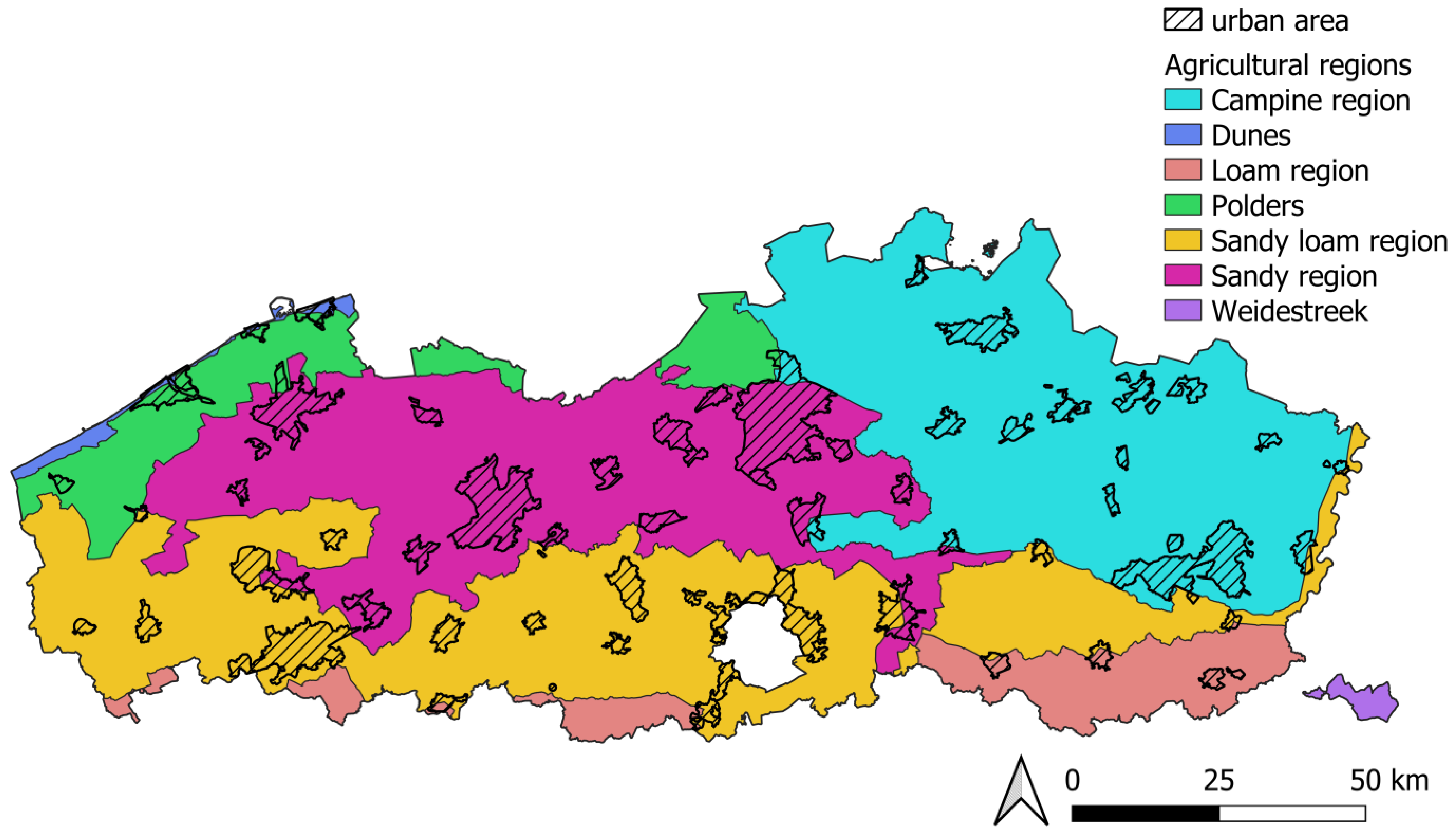
2.1. Study Area
2.2. Methodology for the Land Cover Classification Maps
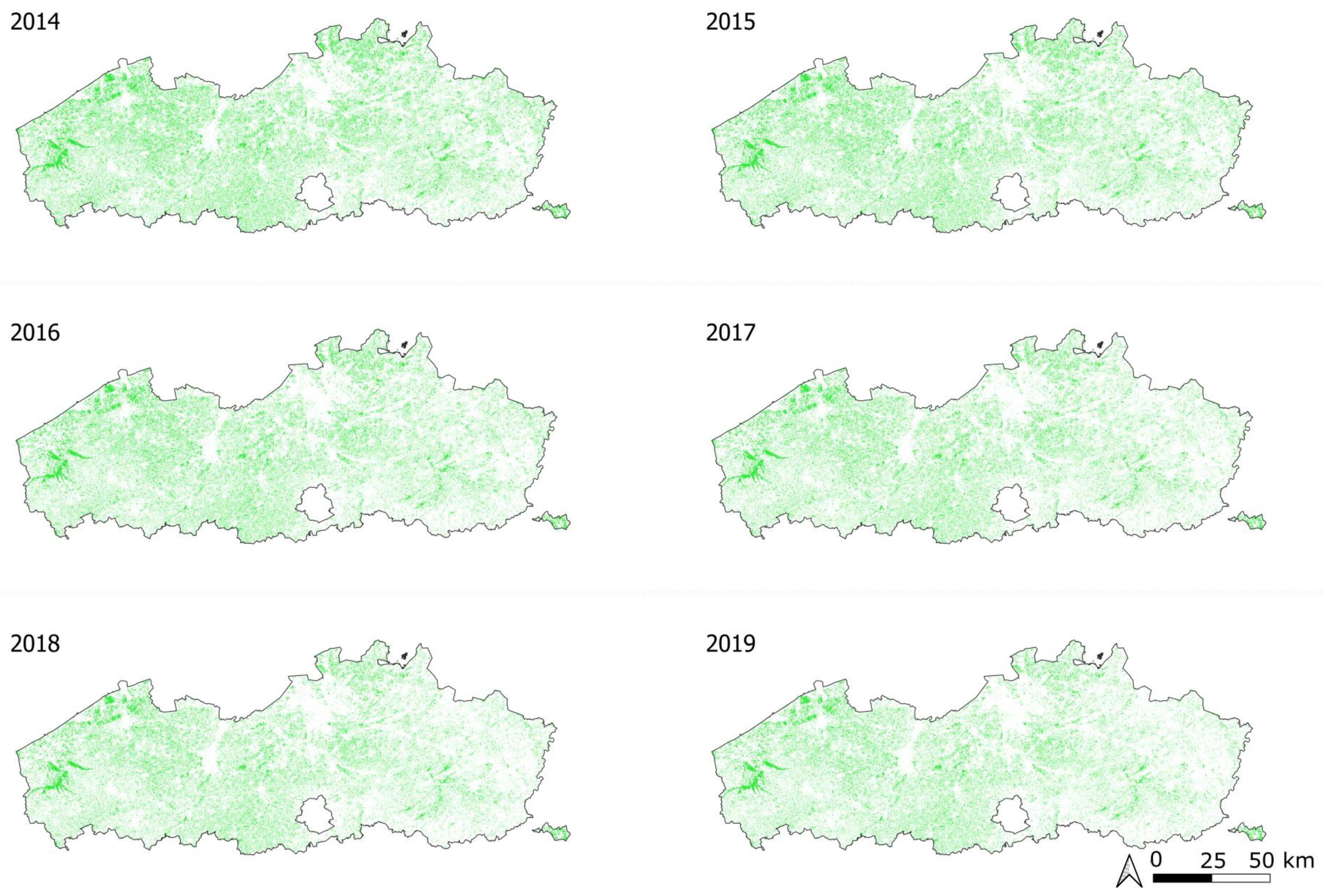
2.3. Evaluation of Grassland Area Based on Land Cover Classification Maps
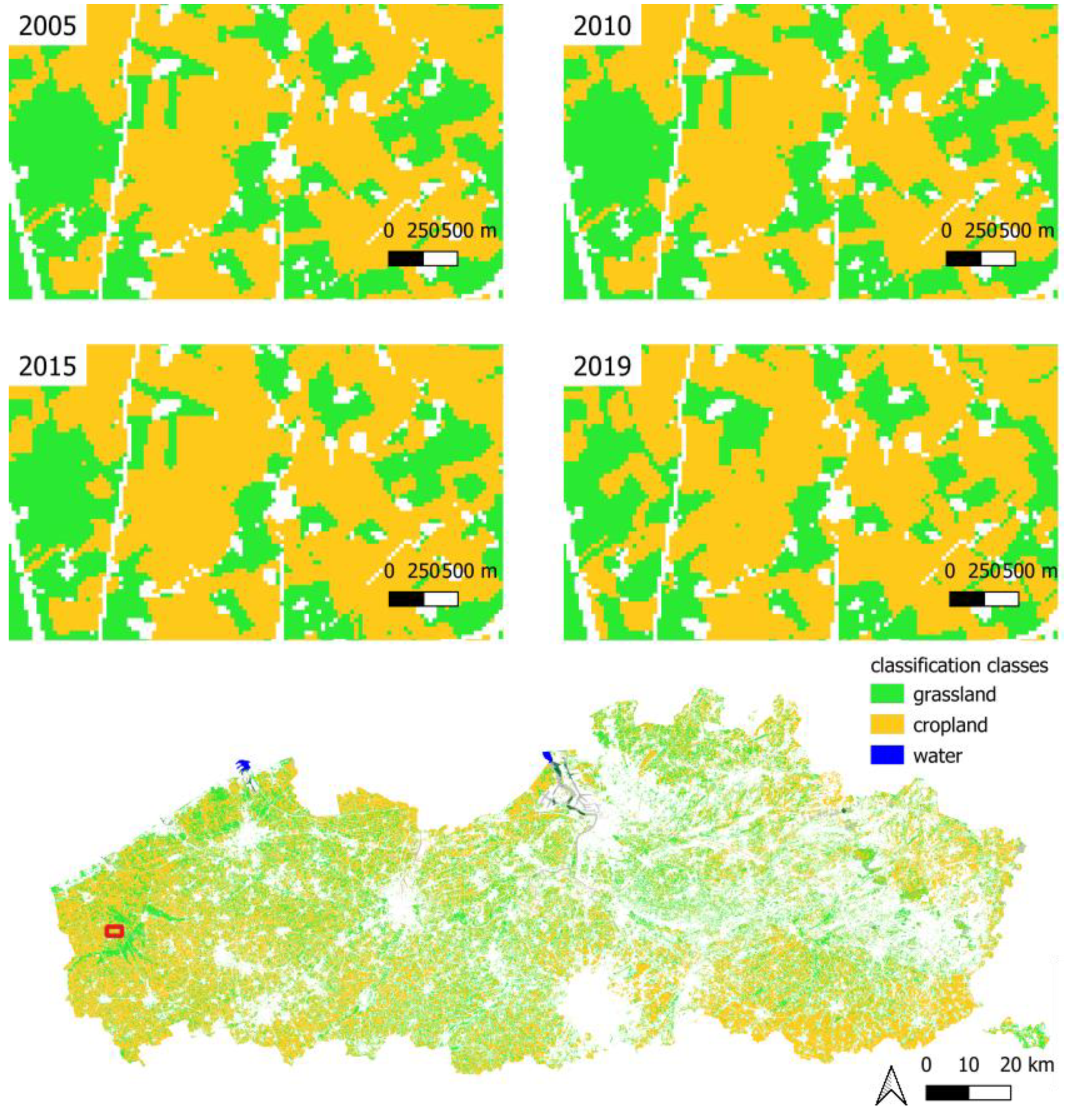
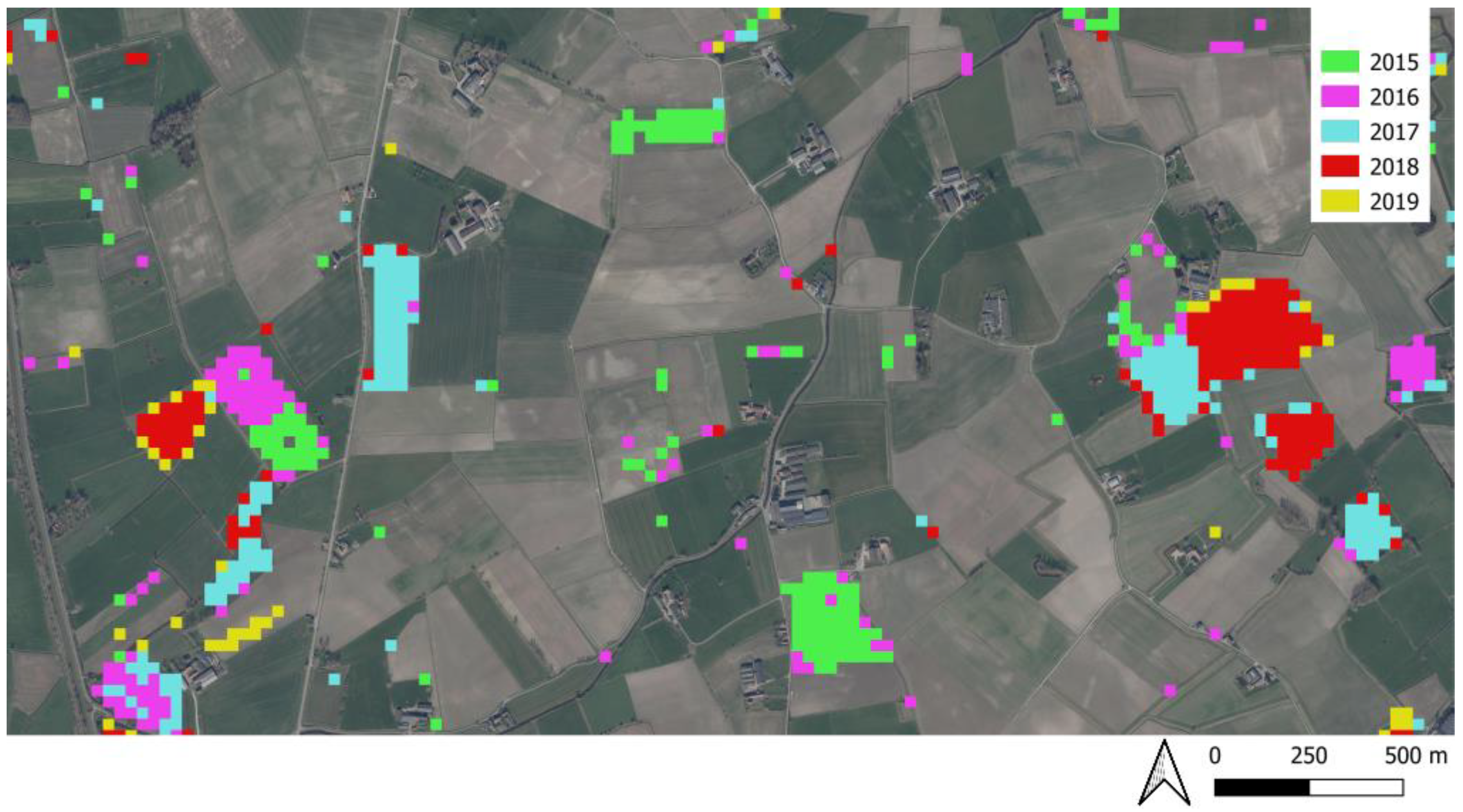
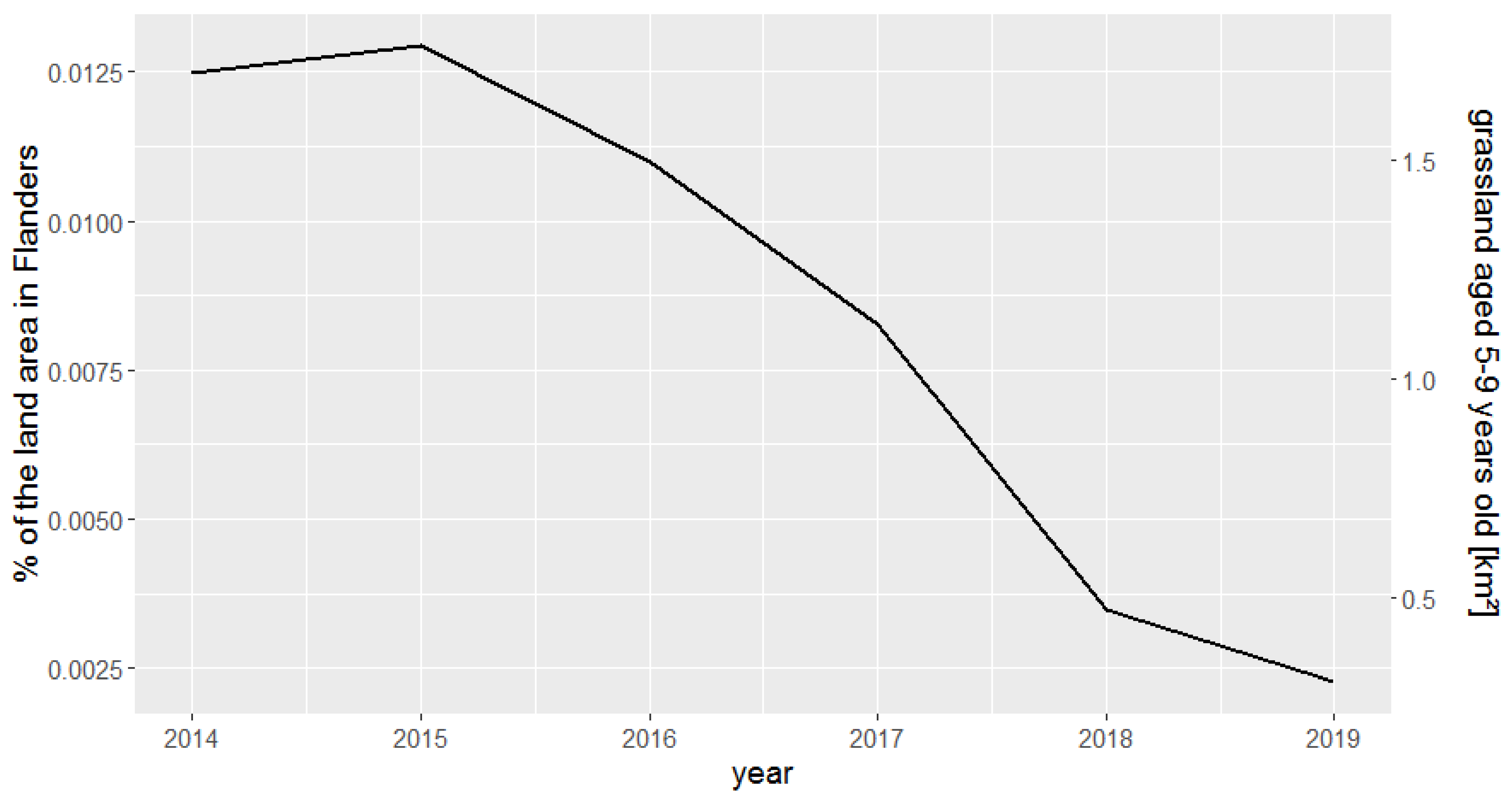
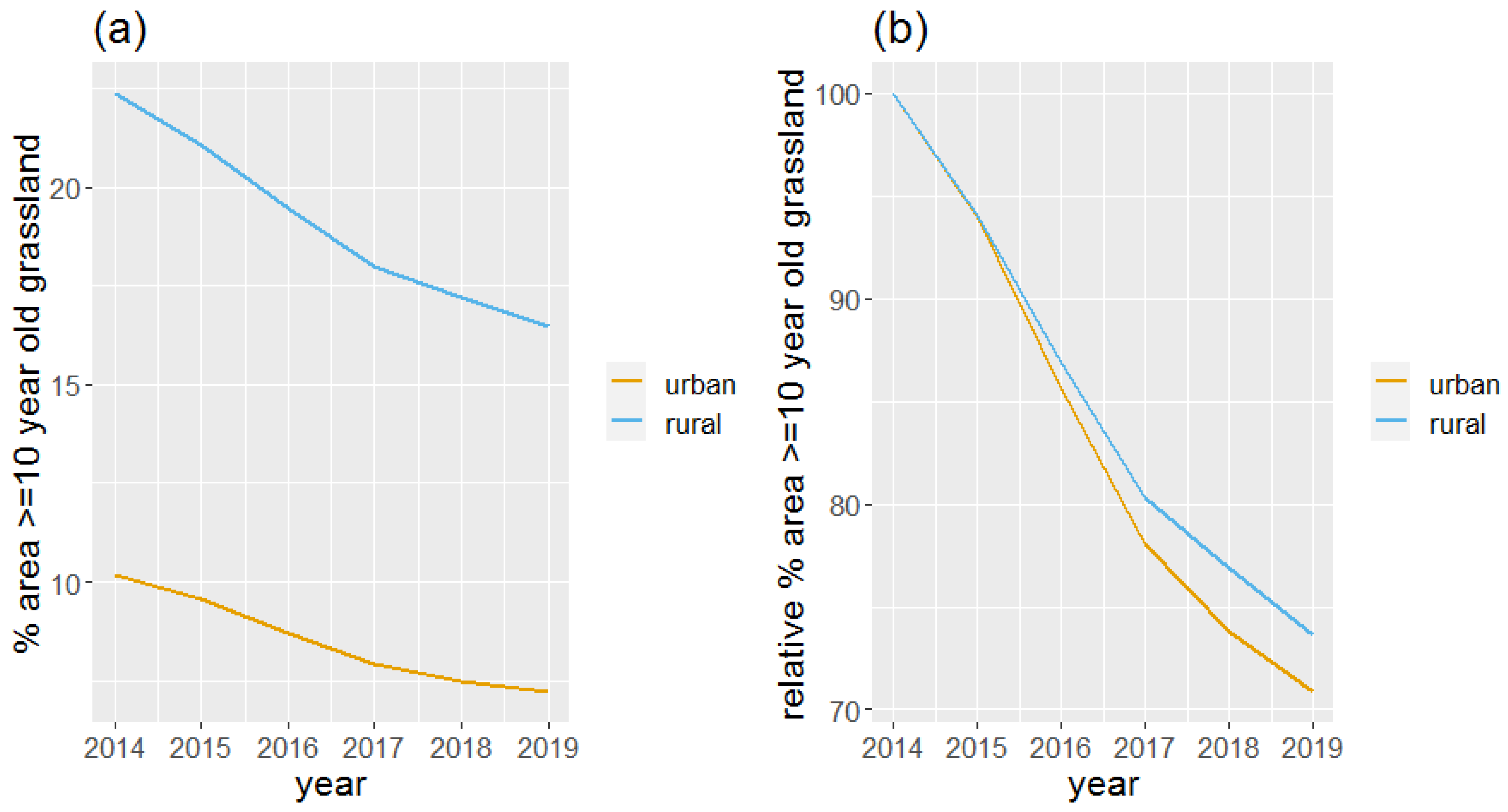
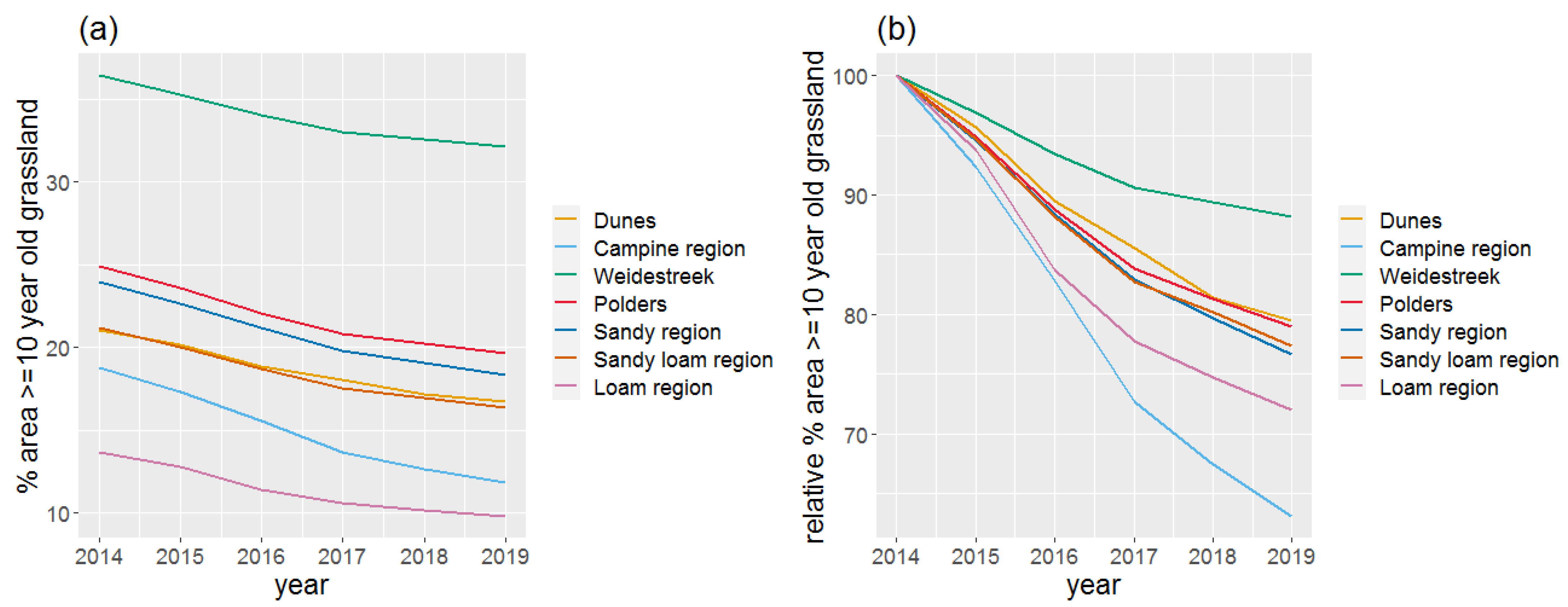
3. Results
4. Discussion
5. Conclusions
Author Contributions
Funding
Data Availability Statement
Conflicts of Interest
Appendix A. Location of the Scenes (Path/Row)
| Path | Row |
| 200 | 25 |
| 200 | 24 |
| 199 | 25 |
| 199 | 24 |
| 198 | 25 |
| 198 | 24 |
| 197 | 25 |
| 197 | 24 |
References
- EUROSTAT Statistics|Eurostat Land Cover Overview by NUTS 2 Regions. Available online: https://ec.europa.eu/eurostat/databrowser/view/LAN_LCV_OVW__custom_3364165/default/table?lang=en (accessed on 14 September 2022).
- Bengtsson, J.; Bullock, J.M.; Egoh, B.; Everson, C.; Everson, T.; O’Connor, T.; O’Farrell, P.J.; Smith, H.G.; Lindborg, R. Grasslands—More Important for Ecosystem Services than You Might Think. Ecosphere 2019, 10, e02582. [Google Scholar] [CrossRef]
- Directorate-General for Environment (European Commission); Silva, J.P.; Eldridge, J.; Jones, W.; O’Hara, E.; Thorpe, E.; Toland, J. LIFE and Europe’s Grasslands: Restoring a Forgotten Habitat; Publications Office of the European Union: Luxembourg, 2008; ISBN 978-92-79-10159-5. [Google Scholar]
- O’Mara, F.P. The Role of Grasslands in Food Security and Climate Change. Ann. Bot. 2012, 110, 1263–1270. [Google Scholar] [CrossRef] [PubMed]
- Soussana, J.-F.; Klumpp, K.; Ehrhardt, F. The Role of Grassland in Mitigating Climate Change. In Proceedings of theOrganising Committee of the 25th General Meeting of the European Grassland Federation IBERS, Wales, UK, 7–11 September 2014; pp. 75–87. [Google Scholar]
- Schils, R.L.M.; Bufe, C.; Rhymer, C.M.; Francksen, R.M.; Klaus, V.H.; Abdalla, M.; Milazzo, F.; Lellei-Kovács, E.; ten Berge, H.; Bertora, C.; et al. Permanent Grasslands in Europe: Land Use Change and Intensification Decrease Their Multifunctionality. Agric. Ecosyst. Environ. 2022, 330, 107891. [Google Scholar] [CrossRef]
- Lal, R. Soil Carbon Sequestration Impacts on Global Climate Change and Food Security. Science 2004, 304, 1623–1627. [Google Scholar] [CrossRef] [PubMed]
- Isselstein, J.; Kayser, M. Functions of Grassland and Their Potential in Delivering Ecosystem Services. Grassl. Sci. Eur. 2014, 19, 199–214. [Google Scholar]
- Ellenberg, H.; Leuschner, C. Vegetation Mitteleuropas Mit Den Alpen: In Ökologischer, Dynamischer Und Historischer Sicht; Utb: Stuttgart, Germany, 2010; Volume 8104, ISBN 3-8252-8104-3. [Google Scholar]
- Kovács, K.F.; Iváncsics, V.; Boromisza, Z.; Valánszki, I. Spatial Trends of Grassland Changes Based on Hungarian Local Studies After 1990 with a Macro-Regional Perspective. Eur. Countrys. 2022, 14, 397–419. [Google Scholar] [CrossRef]
- Huyghe, C.; De Vliegher, A.; Van Gils, B.; Peeters, A. (Eds.) Grasslands and Herbivore Production in Europe and Effects of Common Policies; Éditions Quae: Versailles, France, 2014. [Google Scholar]
- Souverijns, N.; Buchhorn, M.; Horion, S.; Fensholt, R.; Verbeeck, H.; Verbesselt, J.; Herold, M.; Tsendbazar, N.-E.; Bernardino, P.N.; Somers, B.; et al. Thirty Years of Land Cover and Fraction Cover Changes over the Sudano-Sahel Using Landsat Time Series. Remote Sens. 2020, 12, 3817. [Google Scholar] [CrossRef]
- Parente, L.; Mesquita, V.; Miziara, F.; Baumann, L.; Ferreira, L. Assessing the Pasturelands and Livestock Dynamics in Brazil, from 1985 to 2017: A Novel Approach Based on High Spatial Resolution Imagery and Google Earth Engine Cloud Computing. Remote Sens. Environ. 2019, 232, 111301. [Google Scholar] [CrossRef]
- Hansen, M.C.; Potapov, P.V.; Moore, R.; Hancher, M.; Turubanova, S.A.; Tyukavina, A.; Thau, D.; Stehman, S.V.; Goetz, S.J.; Loveland, T.R.; et al. High-Resolution Global Maps of 21st-Century Forest Cover Change. Science 2013, 342, 850–853. [Google Scholar] [CrossRef]
- Sulla-Menashe, D.; Gray, J.M.; Abercrombie, S.P.; Friedl, M.A. Hierarchical Mapping of Annual Global Land Cover 2001 to Present: The MODIS Collection 6 Land Cover Product. Remote Sens. Environ. 2019, 222, 183–194. [Google Scholar] [CrossRef]
- Buchhorn, M.; Lesiv, M.; Tsendbazar, N.-E.; Herold, M.; Bertels, L.; Smets, B. Copernicus Global Land Cover Layers—Collection 2. Remote Sens. 2020, 12, 1044. [Google Scholar] [CrossRef]
- Monteiro, A.T.; Carvalho-Santos, C.; Lucas, R.; Rocha, J.; Costa, N.; Giamberini, M.; da Costa, E.M.; Fava, F. Progress in Grassland Cover Conservation in Southern European Mountains by 2020: A Transboundary Assessment in the Iberian Peninsula with Satellite Observations (2002–2019). Remote Sens. 2021, 13, 3019. [Google Scholar] [CrossRef]
- Fernández-Habas, J.; García Moreno, A.M.; Hidalgo-Fernández, M.T.; Leal-Murillo, J.R.; Abellanas Oar, B.; Gómez-Giráldez, P.J.; González-Dugo, M.P.; Fernández-Rebollo, P. Investigating the Potential of Sentinel-2 Configuration to Predict the Quality of Mediterranean Permanent Grasslands in Open Woodlands. Sci. Total Environ. 2021, 791, 148101. [Google Scholar] [CrossRef]
- De Vroey, M.; de Vendictis, L.; Zavagli, M.; Bontemps, S.; Heymans, D.; Radoux, J.; Koetz, B.; Defourny, P. Mowing Detection Using Sentinel-1 and Sentinel-2 Time Series for Large Scale Grassland Monitoring. Remote Sens. Environ. 2022, 280, 113145. [Google Scholar] [CrossRef]
- Vannoppen, A.; Degerickx, J.; Gobin, A. Evaluating Landscape Attractiveness with Geospatial Data, A Case Study in Flanders, Belgium. Land 2021, 10, 703. [Google Scholar] [CrossRef]
- Pisman, A.; Vanacker, S.; Willems, P.; Engelen, G.; Poelmans, L. Ruimterapport Vlaanderen (RURA). In Een Ruimtelijke Analyse van Vlaanderen; Departement Omgeving: Brussel, Belgium, 2018. [Google Scholar]
- Gorelick, N.; Hancher, M.; Dixon, M.; Ilyushchenko, S.; Thau, D.; Moore, R. Google Earth Engine: Planetary-Scale Geospatial Analysis for Everyone. Remote Sens. Environ. 2017, 202, 18–27. [Google Scholar] [CrossRef]
- Departement Landbouw en Visserij Landbouwgebruikspercelen ALV, 2012|Datasets|Catalogus|Geopunt Vlaanderen. Available online: https://www.geopunt.be/catalogus/datasetfolder/58F5DD1A-A2CA-4CA1-AD9A-4041F8CF45B7 (accessed on 14 October 2022).
- Fritz, S.; See, L.; Perger, C.; McCallum, I.; Schill, C.; Schepaschenko, D.; Duerauer, M.; Karner, M.; Dresel, C.; Laso-Bayas, J.-C.; et al. A Global Dataset of Crowdsourced Land Cover and Land Use Reference Data. Sci. Data 2017, 4, 170075. [Google Scholar] [CrossRef] [PubMed]
- Agentschap Digitaal Vlaanderen Bodembedekkingskaart (BBK), 1m Resolutie, Opname 2015|Datasets|Catalogus|Geopunt Vlaanderen. Available online: https://www.geopunt.be/catalogus/datasetfolder/0230a22f-51c0-4aa5-bb5d-0d7eeeaf0ce8 (accessed on 14 October 2022).
- Markham, B.L.; Storey, J.C.; Williams, D.L.; Irons, J.R. Landsat Sensor Performance: History and Current Status. IEEE Trans. Geosci. Remote Sens. 2004, 42, 2691–2694. [Google Scholar] [CrossRef]
- White, J.C.; Wulder, M.A.; Hobart, G.W.; Luther, J.E.; Hermosilla, T.; Griffiths, P.; Coops, N.C.; Hall, R.J.; Hostert, P.; Dyk, A.; et al. Pixel-Based Image Compositing for Large-Area Dense Time Series Applications and Science. Can. J. Remote Sens. 2014, 40, 192–212. [Google Scholar] [CrossRef]
- Agentschap Digitaal Vlaanderen WMTS Orthofotomozaïek, Middenschalig, Winteropnamen, Kleur, Meest Recent, Vlaanderen|Webservices|Catalogus|Geopunt Vlaanderen. Available online: https://www.geopunt.be/catalogus/webservicefolder/7059fc59-2807-42e8-b7ea-846e8c6ab150 (accessed on 17 October 2022).
- Gong, W.; Fang, S.; Yang, G.; Ge, M. Using a Hidden Markov Model for Improving the Spatial-Temporal Consistency of Time Series Land Cover Classification. ISPRS Int. J. Geo-Inf. 2017, 6, 292. [Google Scholar] [CrossRef]
- Abercrombie, S.P.; Friedl, M.A. Improving the Consistency of Multitemporal Land Cover Maps Using a Hidden Markov Model. IEEE Trans. Geosci. Remote Sens. 2016, 54, 703–713. [Google Scholar] [CrossRef]
- Bolund, P.; Hunhammar, S. Ecosystem Services in Urban Areas. Ecol. Econ. 1999, 29, 293–301. [Google Scholar] [CrossRef]


| 2012 Historical Land Cover Classification Map | ||||
|---|---|---|---|---|
| Classification result | Ground truth | |||
| Forest | Grassland | Arable land | Urban/bare/water | |
| Forest | 1663 | 39 | 39 | 0 |
| Grassland | 2 | 4577 | 1006 | 43 |
| Arable land | 37 | 1680 | 9893 | 83 |
| Urban/bare/Water | 0 | 4 | 12 | 968 |
| 2015 historical land cover classification map | ||||
| Classification result | Ground truth | |||
| Forest | Forest | Forest | Forest | |
| Forest | 1715 | 38 | 19 | 99 |
| Grassland | 2 | 5325 | 967 | 35 |
| Arable land | 9 | 989 | 9894 | 82 |
| Urban/bare/Water | 0 | 3 | 15 | 943 |
Disclaimer/Publisher’s Note: The statements, opinions and data contained in all publications are solely those of the individual author(s) and contributor(s) and not of MDPI and/or the editor(s). MDPI and/or the editor(s) disclaim responsibility for any injury to people or property resulting from any ideas, methods, instructions or products referred to in the content. |
© 2023 by the authors. Licensee MDPI, Basel, Switzerland. This article is an open access article distributed under the terms and conditions of the Creative Commons Attribution (CC BY) license (https://creativecommons.org/licenses/by/4.0/).
Share and Cite
Vannoppen, A.; Degerickx, J.; Souverijns, N.; Gobin, A. Spatio-Temporal Dynamics in Grasslands Using the Landsat Archive. Land 2023, 12, 934. https://doi.org/10.3390/land12040934
Vannoppen A, Degerickx J, Souverijns N, Gobin A. Spatio-Temporal Dynamics in Grasslands Using the Landsat Archive. Land. 2023; 12(4):934. https://doi.org/10.3390/land12040934
Chicago/Turabian StyleVannoppen, Astrid, Jeroen Degerickx, Niels Souverijns, and Anne Gobin. 2023. "Spatio-Temporal Dynamics in Grasslands Using the Landsat Archive" Land 12, no. 4: 934. https://doi.org/10.3390/land12040934
APA StyleVannoppen, A., Degerickx, J., Souverijns, N., & Gobin, A. (2023). Spatio-Temporal Dynamics in Grasslands Using the Landsat Archive. Land, 12(4), 934. https://doi.org/10.3390/land12040934


